Coastal geology of the Holocene progradant plains of sandy beach ridges in Santa Catarina state, Southeastern Brazil Geologia costeira das ...
←
→
Page content transcription
If your browser does not render page correctly, please read the page content below
Quaternary and Environmental Geosciences (2021) 12(1):1-17

Coastal geology of the Holocene progradant plains of sandy beach ridges
in Santa Catarina state, Southeastern Brazil
Geologia costeira das planícies progradantes holocênicas de cordões
litorâneos arenosos no estado de Santa Catarina, sul do Brasil
                                                                                               Norberto Olmiro Horn Filho

                                                                                                Universidade Federal de Santa Catarina

                                                                                                                  hornfilho@gmail.com
            Abstract
            Beach ridges are indicators of supratidal and intertidal depositional environments built by waves. The major
            factors that influence on the ridge’s formation is related to antecedent topography, sediment supply,
            sedimentary balance, and substrate gradient. They consist of siliciclastic and/or bioclastic sediments whose
            grain size varies from very coarse sand to very fine sand. At Santa Catarina state, progradant plains are related
            to Pleistocene and Holocene regressive marine processes. The Holocene marine terraces, object of this study,
            predominate in the coastal plains of Passo de Torres, Pinheira, Jurerê, Tijucas and Navegantes, presenting
            heights from 3 to 6 m in elevations and 1 to 2 m in depressions. The ridge deposits are constituted by sandy
            sediments, medium to very fine, composed by quartz, opaque and heavy minerals and shell fragments. The
            runnel deposits comprehend silt-sand-clayey sediments enriched by organic matter. The evolution of
            Holocene Santa Catarina beach ridges is connected to the regressive events occurred after 5,1 ky BP that
            indicate the position of paleo coastlines and mean sea level of the Holocene.
            Key words: Geomorphology; Sedimentology; Coastal evolution.
            Resumo
            Os cordões regressivos são indicadores de ambientes deposicionais formados por ondas sob regime de supra
            e intermarés. Os fatores mais relevantes que influenciam na formação dos cordões estão relacionados à
            topografia antecedente, suprimento sedimentar, balanço sedimentar e gradiente do substrato. Os cordões
            consistem em sedimentos siliciclásticos e bioclásticos, cujo tamanho de grão varia desde areia muito grossa
            à areia muito fina. No estado de Santa Catarina, as planícies progradantes estão relacionadas aos processos
            regressivos marinhos ocorridos durante o Pleistoceno e Holoceno. Os terraços marinhos holocênicos, objeto
            desse estudo, predominam nas planícies costeiras de Passo de Torres, Pinheira, Jurerê, Tijucas e Navegantes,
            apresentando altitudes que variam de 3 a 6 m nas elevações e 1 a 2 m nas depressões. As cristas dos depósitos
            são constituídas por sedimentos arenosos, médios à muito finos, compostos de quartzo, minerais opacos e
            pesados e fragmentos de conchas. As depressões dos depósitos compreendem sedimentos síltico areno
            argilosos enriquecidos em matéria orgânica. A evolução dos cordões litorâneos holocênicos de Santa Catarina
            está correlacionada aos eventos regressivos ocorridos pós 5,1 ka que indicam a posição das paleolinhas de
            costa e o nível médio do mar do Holoceno.
            Palavras-chave: Geomorfologia; Sedimentologia; Evolução costeira.

                                                                         terraces. Transgressive and regressive marine processes
1. Introduction
                                                                         evidenced along of Holocene are important to explain
  In Brazil, coastal zones are distributed along of 7.367                the evolution of the coastal plains, shaped mainly in the
km of coastline, enclosing an area of 442.000 km²,                       last 7 ky BP.
corresponding to nearly 4% of the Brazilian territory.                     The coastal deposits located between marine and
This coastal zone presents a diversity of ecosystems,                    continental areas are extremely fragile; hence practical
including sand dunes, beaches, inlets, mangroves,                        actions are important to conservation and management
estuaries, restingas, reefs and beach ridge plains.                      of these systems (Lacerda et al.1984).
Quaternary deposits (Pleistocene and Holocene) are                         The objective of this study is to characterize the
founded on this area, and its origin is linked to marine                 morphology, texture, and paleogeography of progradant
and eolic processes, generating deposits of different                    plains of Quaternary sandy beach ridges in Santa
shapes, ages, and textures.                                              Catarina state, focusing mainly on Holocene terraces.
  Brazilian Quaternary coastal plains stretch out from                     The methodology applied to this study consisted in
Amapá      to     Rio     Grande      do    Sul      states.             bibliographic revision, interpretation of aerial photos
Geomorphologically, these plains are constituted by                      (1:25.000) and satellite images (several scales), field
marine terraces, ridges, beaches, dunes, cliffs, spits, tidal            works and textural analyses.
plains, besides of submersed features, like lagoon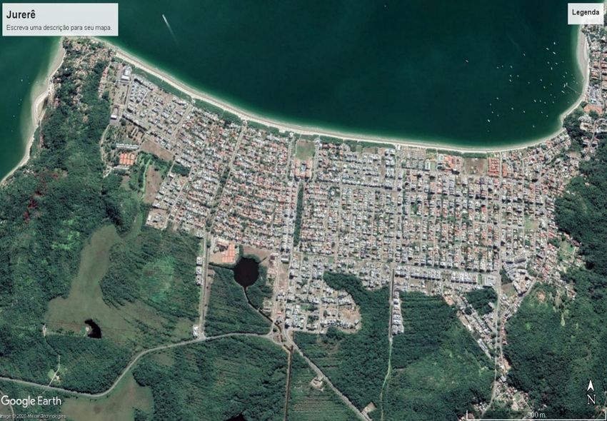
Quaternary and Environmental Geosciences (2021) 12(1):1-17

2. Background                                                                 elongated deposits, generally composed by sand, and
                                                                              less frequently constituted by gravel or bioclastic
   Beach ridge is a term frequently used on coastal
                                                                              (shells), disposed parallel to the paleo coastlines and
literature, but with different meanings. Redman (1852,
                                                                              separated by depressions. Each ridge is a component of
1864) introduced the term beach ridge in the classical
                                                                              progradant zone and formed by action of storm waves,
work of changes of South and West England shoreline,
                                                                              coastal currents, and tides.
being originally associated to storm waves of high
                                                                                 Several theories have been proposed to explain the
energy.
                                                                              genesis of the beach ridges. The theories are not
   In other hand, Johnson (1919) presented this term to
                                                                              conclusive once there is not a mechanism able to explain
describe features built from storm waves of low energy.
                                                                              the genesis of all types.
   Davies (1968) defined beach ridges as ridges parallels
                                                                                 According to Schwarz (1971), the polygenetic origin
or sub parallels, which oscillate from two or more of 100
                                                                              should be accepted as one of the possible explanations
unities built of sands, shells, and gravels, located on the
                                                                              for sandy beach ridges formation. Based on the
emerged portion of actual beaches, each ridge
                                                                              traditional school, most of the researchers claim the
corresponding to the position of a paleo shoreline. Bates
                                                                              marine origin for beach ridges and exclude the origin
& Jackson (1980) described beach ridges as an
                                                                              from foredune (Short 1984, Taylor & Stone 1996).
accumulation of beach and/or eolic sediments, deposited
                                                                                 The genesis of the regressive beach ridge plains
on the high beach zone by waves that break beyond
                                                                              suggests formation by marine processes, which
backshore because of storms or ordinary tides. Suguio
                                                                              sediments are deposited slowly as it occurs in an
(1992) described and named beach ridges as typical
                                                                              upswing beach (Figure 1).

Figure 1: Origin of the regressive beach ridges proceeding from high beach ridge (MSL = mean sea level).
   According Hesp et al. (2005), many progradant                              this case, genesis, and growth by one group of regressive
barriers and some dune fields in the world have been                          sandy beach ridges was anchored in basement rocks or
termed “beach ridge”' plains, but the actual genesis of                       preexistent sedimentary deposits.
the “'ridges” is often unknown. Use of the terms, berms,                        Carter (1986) classified two types of progradant beach
beach ridges and foredunes is also confusing in the                           ridges: (i) beach ridges formed for gradual attachment
literature because their definitions are highly variable                      and coalescent of swash bars by the normal coastline
and are commonly used interchangeably. Beach ridges                           sedimentary transport and, (ii) beach ridges formed by
are re-defined as entirely wave formed deposits which                         sedimentary transport along the shore, from one side to
are most formed during high wave conditions and/or                            the other of submersed bars, resulting in an addition of
elevated water levels. Foredunes are formed by eolic                          sediment to the emerged beach profile by dominant
sand deposition rear the backshore.                                           waves.
   The fluctuation of sea level is an important parameter                       Beach ridges were classified by Stapor (1988) and
to control the orientation and morphology of ridges and                       Stapor et al. (1988) as linear sandy deposits constituted
runnels, with few other changes regarding to the energy                       by a succession of ridges and runnels, parallel to the
conditions. In a study about the genesis of Australian                        coast, where the ridges are situated in elevations above
sandy beaches, Hesp (1984) followed the proposed                              of mean high water level, while the bottom of the
models of Davies (1958), Bird (1960) and Thom (1964),                         depressions (swales) are in altitudes near to the low tide
confirming that the growth of ridges are related to eolic                     medium level.
deposition through analysis of the internal structures. In

                                                                                                                                      2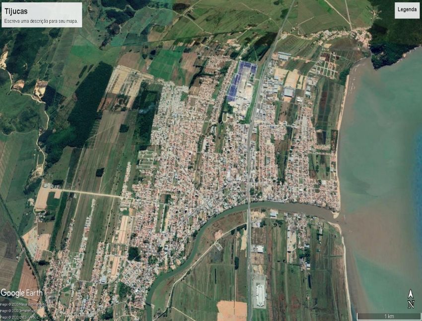
Quaternary and Environmental Geosciences (2021) 12(1):1-17
Tanner (1987, 1992) and Tanner & Demirpolat (1988) integrant of a progradant sequence. These ridges plunge
recognized tree types of sandy-gravel beach ridges: (i) in direction to the continent and are constituted by fine
swash ridges and storm ridges, related to the marine to medium sand.
genetic processes; (ii) very shallow water ridges, typical
3. The study area
of lagoons; and (iii) foredune ridges areas, originated
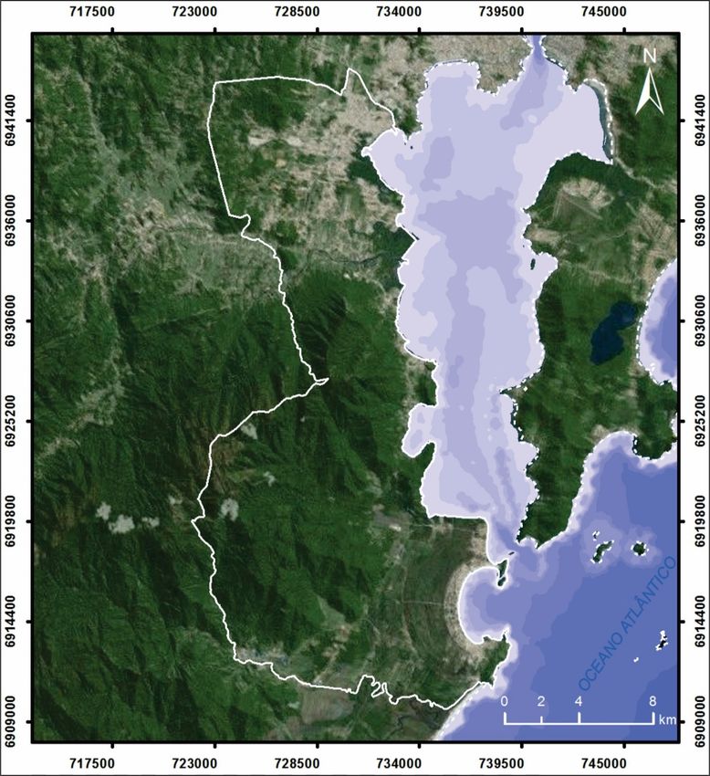
from eolic mechanisms. The study area corresponds to the Santa Catarina
Otvos (2000) classified the beach ridges deposits, coast, located in Southern Brazil, limited by the Saí-
based on geologic agents in two categories: (i) beach Guaçu river (25º57'41"S.) and Mampituba river
ridges built from waves, subdivided in storm ridges, (29º23'55"S.) (Figure 2). The coastal zone of the state is
barrier ridges and chenier ridges (Buynevich et al. divided in three sectors: Northern, Central and Southern
2005); and (ii) beach ridges built from winds. Storm (Horn Filho et al. 1994), which coastline is subject to
ridges occur in glacial coasts or in erosive coasts, action of oceanographic dynamic of Atlantic ocean
produced by high energy events that allow accumulation under influence of waves, alongshore and rip currents
of lithoclastic and bioclastic sediments. and tides.
Lastly, Adams & Wesnousky (1998) used barrier The location of the Holocene sandy beach ridges listed
ridge and beach barrier terms to the sandy-gravel ridges in this research appears on Figure 2, being called Passo
formed in the Pleistocene tide plains. The chenier ridges de Torres ❶ in the Southern sector and Pinheira ❷,
develop along of the coast receives clay and sandy Jurerê ❸, Tijucas ❹ and Navegantes ❺, all in the
sediments, alternately. Remnant foredunes are Central sector of the coast.
considered eolic beach ridges, parallel to the coast,
developing from the shore face zone and might be
5
4
3
2
1
Figure 2: Location of the state of Santa Catarina in Southern Brazil, its three coastal compartments and five expositions of Holocene sandy beach ridges.
The deposits of the coastal plain of Santa Catarina The winds influence on the regime, energy, and
have been reshaped by Quaternary relative sea level incidence of waves on the coast. The more frequent
oscillations. These deposits are related to those listed in directions of the waves in the region are from N-NE and
Paraná coastal plain (Angulo 1992) and Rio Grande do S-SE directions (Horn Filho et al. 2020).
Sul coastal plain (Villwock et al. 1986). Transgressive Micro tide predominates in Santa Catarina coast (< 2
and regressive events during upper Pleistocene and m) classifying it as a shoreline dominated by waves
Holocene generated the depositional systems barrier according to Davies & Hayes (1984).
lagoon III and IV, on the Southeastern coastal plains of The Northern sector extends from Saí-Guaçú river
Brazil. (25°57'41"S.) to Barra Velha (26º40'S.), characterized
by a wide coastal plain where detach São Francisco do
3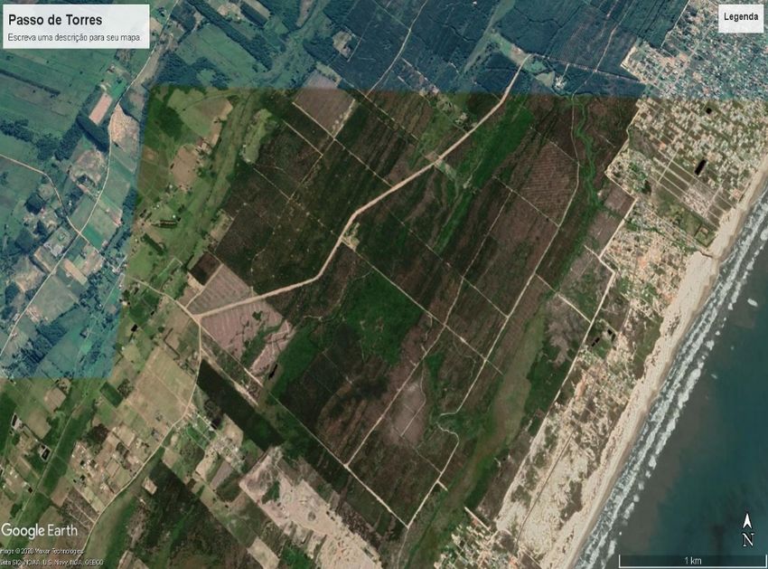
Quaternary and Environmental Geosciences (2021) 12(1):1-17

Sul island, Babitonga bay and presence of the Serra do                              northward of the coastal province, respectively. The
Mar.                                                                                Southern basement comprehends sedimentary and
  The Central sector situated between Barra Velha                                   basaltic rocks; Central basement is dominantly granitic,
(26º40'S.) and Garopaba (28º00'S.) is characterized by                              and the Northern basement consists of granitic and
the proximity of the crystalline basement narrowing the                             metamorphic lithotypes, as gneiss, migmatite, granulite
coastal plain, where detach Porto Belo peninsula and                                and schist. Pelotas and Santos basins are constituted by
Santa Catarina island.                                                              two interdigitated sectors: emerged sector, above mean
  The Southern sector located between Garobapa                                      sea level; and submerged sector, below mean sea level;
(28ºS.) and Mampituba river (29°23'55"S.) is                                        represented, respectively, by coastal plain and
distinguished by an extensive coastal plain, shows                                  continental shelf.
several large and elongated paleolagoons and lagoons                                  The coastal plain includes deposits of two depositional
typical of the barrier lagoon depositional system. In this                          systems: continental system and transitional or coastal
sector detach the lagoon complex of the Santo Antônio,                              system (Horn Filho & Diehl 1994, Horn Filho 2003),
Imaruí and Mirim lagoons.                                                           according to Figure 3.
                                                                                      The Holocene sandy beach ridges in Santa Catarina
4. Holocene sandy beach ridges in Santa Catarina
                                                                                    coastal plain are related to morphological features
coastal plain
                                                                                    lagoon terraces; dunes and littoral terraces; beach ridges,
  Coastal plain is considered the emerged sector of the                             viewed on the Figure 3, associated to lagoonal, beach
coastal province, that also includes the submerged                                  marine and eolic deposits.
continental shelf. The coastal plain is described as a                                Continental system is associated to the hillside of
lowland (till 50-60 m of altitude), composed mainly by                              highlands, holding colluvial, alluvial fan and fluvial
sedimentary terrains and crystalline rocks, while the                               deposits of undifferentiated Quaternary.
continental shelf is described as a shallow region (till                              Coastal system, in majority barrier lagoon type,
150-200 m of depth) (Villwock 1972)                                                 associated to sea level changes, includes Quaternary
  Santa Catarina coastal province is constituted by two                             (Pleistocene and Holocene; 120-18 ky BP and 5,1 ky
main unities: the basement and Pelotas and Santos                                   BP, respectively).
oceanic marginal basins, located southward and

Figure 3: Geological sketch of the Santa Catarina coastal province, showing main morphological features and associated deposits: (1) elluviums; (2)
colluviums; (3) alluvial fans; (4) flood plains; (5) and (12) fluvial terrace; (6) levees; (7) cliffs; (8) and (13) lagoon terraces; (9) and (11) dunes; (10)
and (14) littoral terraces and beach ridges; (15) shell-middens; (16) tidal plains; (17) beaches; (18) mean sea level (Horn Filho et al. 1996).
  There are also sediments constructed by                                           Central and Northern areas are composed of very coarse
anthropogenic influence, including prototechnogenic                                 to fine sands.
Deposit (shell-middens) and technogenic Deposit                                        Santa Catarina progradant plains related to Quaternary
(embankments and mineral residue wastes).                                           transgressive and regressive marine processes are
  The Holocene and recent deposits reach altitudes till                             classified as Pleistocene and Holocene ridges.
10 m; the upper Pleistocene deposits till 18 m and,                                    The Pleistocene ridges take place in São Francisco do
hillside deposits close to the basement shows heights                               Sul island, Rio Vermelho (Santa Catarina island), Paulo
between 30 and 40 m. Exceptionally, sand dunes are                                  Lopes and Araranguá regions.
higher than 30 m.                                                                      The main Holocene ridges, object of this study, are
  Beach sediments located between coastal plain and                                 situated in Passo de Torres (❶), Pinheira (❷), Jurerê
continental shelf, along of 538 km of Santa Catarina                                (❸), Tijucas (❹) and Navegantes (❺) coastal plains,
coast, are composed of sandy sediments that exhibit                                 whose location can be seen in Figure 2.
different texture. The beaches of the Southern coast are                               There are still other expositions of Holocene
dominated by fine sands; while the beaches of the                                   progradant plains in Santa Catarina, such as in the
                                                                                    coastal plains of Sombrio, Laguna and Itapoá, however,

                                                                                                                                                           4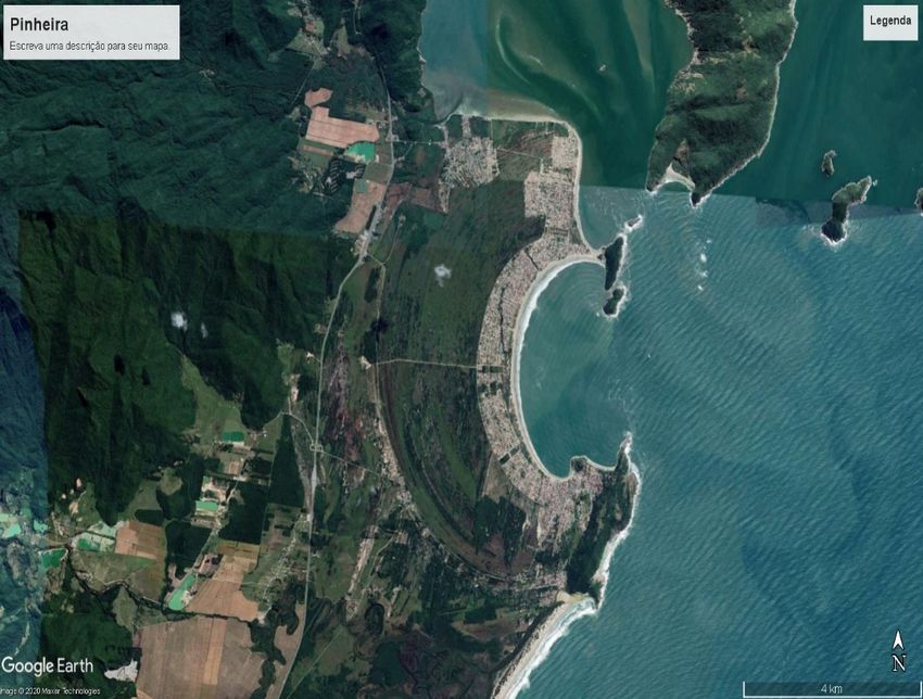
Quaternary and Environmental Geosciences (2021) 12(1):1-17

they were not selected for their representation in this                         be inserted in the main stage (development and
research.                                                                       urbanization).
  In the following, the five main exposures of                                    Passo de Torres coastal plain (❶), located in the
progradant plains from coastal regressive ridges in the                         Southern coast of Santa Catarina state (UTMx
state of Santa Catarina, from south to north, will be                           6760686,12; UTMy 625996,61), in the municipality of
described one by one.                                                           Passo de Torres, is constituted by retilineous and flat
  Coastal areas have been occupied indiscriminately in                          ridges presenting 10 km of length, 6 km of width and
recent years, due to the use of coastal space, landscape,                       altitudes ranging between 6 and 24 m. Fine sandy
and tourist vocation. Butler (1980), Smith (1991) and                           sediments over ridges and silt-sandy sediments in
Polette (1993) proposed development stages for coastal                          runnels characterize a typical barrier lagoon system,
balnearies. Thus, the coastal area of Passo de Torres                           whose crests are oriented NE-SW with azimuth 40°.
would be framed in the initial stage (exploration,                                Except for the eolic and marine deposits towards
original community, and pre-tourism), while the coastal                         Bellatorres beach, the deposits of the progradant plains
areas of Tijucas, Navegantes, Jurerê and Pinheira, would                        are still uncharacterized by urbanization, being only
                                                                                covered by exotic vegetation (Figure 4 and Figure 5).

Figure 4. Image showing the approximate limits of the Holocene progradant coastal sandy ridges of Passo de Torres in the municipality of Passo de
Torres on the Southern coast of Santa Catarina. The white polygon represents the territorial limits of the municipality of Passo de Torres. The yellow
polygon represents the area of the regressive ridges as shown in Figure 5.
  Bellatorres beach behaves like an exposed, straight,                          represents the plain of coastal regressive ridges formed
and dissipative, low slope of the beach face and                                during the progradation of the lagoon barrier IV system,
composed of fine well sorted sand (Horn Filho et al.                            of Holocene age. They show a succession of ridges and
2020).                                                                          runnels, arranged in the NE-SW direction, and aligned
  Mudat et al. (2006) studied the beach marine                                  parallel to the current coastline. The composition is light
sediments of the Sombrio region, located northeast of                           sandy sediments with the presence of organic matter in
the Passo de Torres coastal plain, inferring an average                         the runnels, which indicates darker colors.
altitude of 4 m and an average width of 2.5 km. It

                                                                                                                                                    5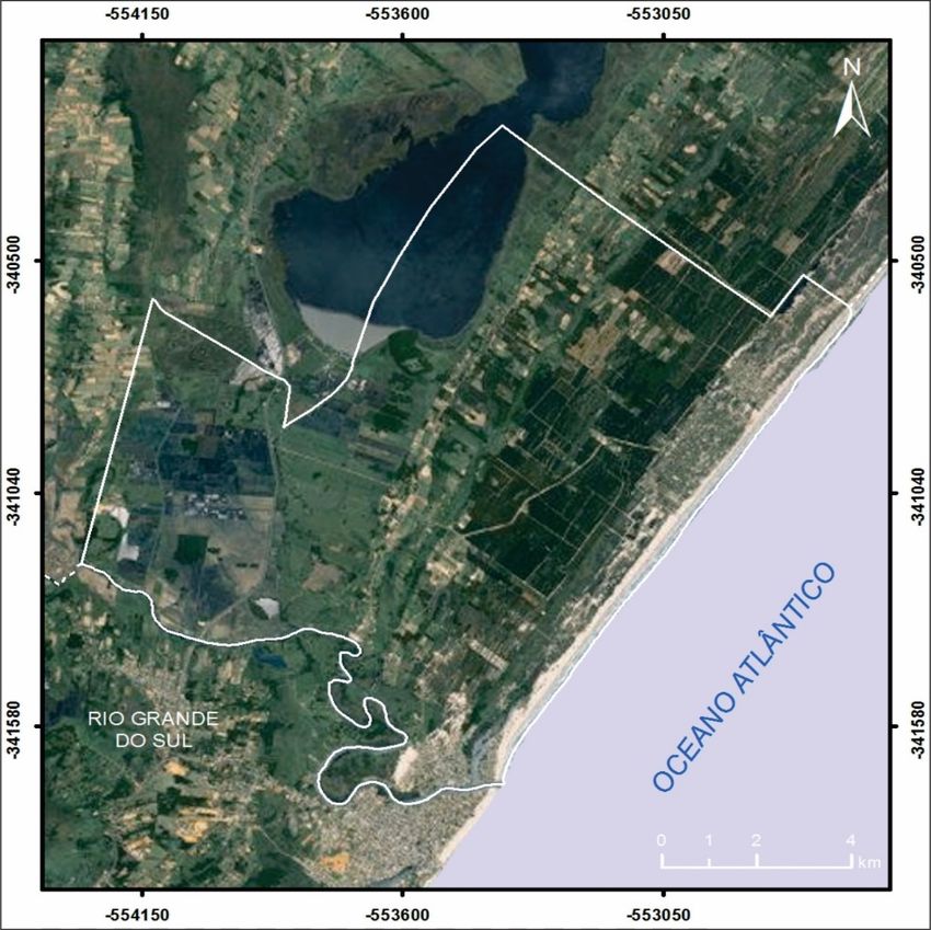
Quaternary and Environmental Geosciences (2021) 12(1):1-17

Figure 5: Images showing the coastal plain of Passo de Torres on the Southern coast of Santa Catarina. The upper image refers to the monochromatic
aerial photograph of the year 1978, scale 1: 25,000 and the lower image of 17/5/2019 from Google Earth. In both images, the ridges aligned parallel to
the coastline of Belatorres beach are evident near the Atlantic ocean. In 1978 photo, a sangradouro is well seen at the northeast end of the area (yellow
circle) drifting to south. In the image of 2019, the ridges are covered with exotic vegetation, greatly increasing the altitudes of the coastal plain. The
yellow dotted line in both images represents the coastal ridges.

  Pinheira coastal plain (❷), located in the Central                              sediments in runnels characterize a typical swash-ridge
coast of Santa Catarina state (UTMx 6914785,14; UTMy                              and foredune ridges, whose orientation of the crests are
734592,34), in the municipality of Palhoça, is                                    variable (N-S; NE-SW; SE-NW). The coastal plain
constituted by arched and flat ridges presenting 9 km of                          displays on the Southern sector Holocene fine sandy
length, 4 km of width and altitudes ranging between 1                             eolic sediments covering the ridges (Figure 6 and Figure
and 6 m. Fine sandy sediments over ridges and silt-sandy                          7).

                                                                                                                                                        6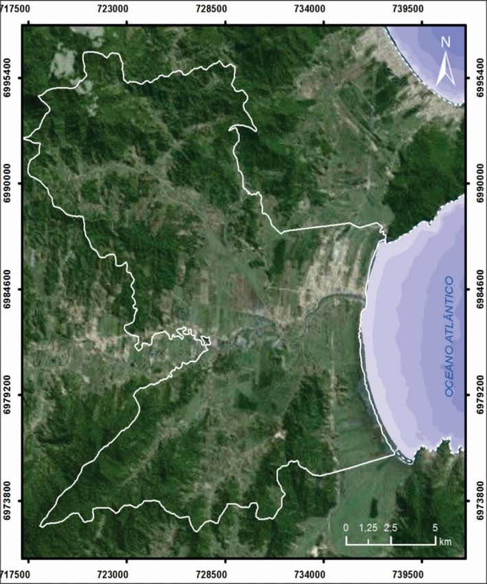
Quaternary and Environmental Geosciences (2021) 12(1):1-17

  Pinheira beach behaves like an exposed, parabolic,                           In the coastal plain of Pinheira, Hein et al. (2013)
intermediate, low slope of the beach face and composed                       mapped sands deposited in the intertidal zone, forming
of fine very well sorted sand (Horn Filho et al. 2020).                      successive ridges of beach and dune, and welding the
                                                                             migration of bars towards the continent.

Figure 6: Image showing the approximate limits of the Holocene progradant coastal sandy ridges of Pinheira in the municipality of Palhoça, on the
Central coast of Santa Catarina.

                                                                                                                                               7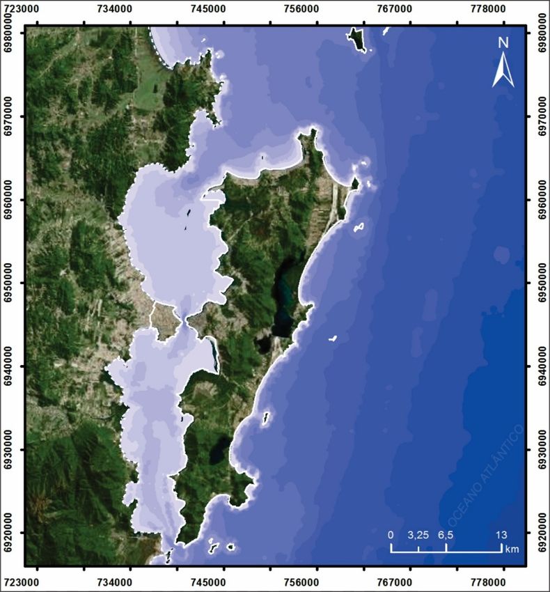
Quaternary and Environmental Geosciences (2021) 12(1):1-17

Figure 7: Images showing the ridges of the coastal plain of Pinheira on the Central coast of Santa Catarina. The upper image refers to the monochromatic
aerial photograph of the year 1978, scale 1: 25,000 and the lower image of 17/5/2019 from Google Earth. In both images, the ridges and runnels aligned
parallel to the current coastline of Pinheira beach adjacent Pinheira cove are evident. In the 1978 photo, the dunes (black dotted line) covering the ridges
and oriented NE-SW are visible at the Southern end of the area. In the image of 2019, the entire frontal region of the plain is already anthropized. The
dotted yellow lines represent the exposure of arched ridges arranged parallel to the current coastline.
  Jurerê coastal plain (❸), located in the Central coast                           swash-ridge built by waves, whose orientation of the
of Santa Catarina state (UTMx 6961480,36; UTMy                                     crests is virtually E-W. The ridge sandy sediments of the
746676,28), in the Santa Catarina island, municipality                             coastal plain are occupied at the present time by an
of Florianópolis, is constituted by retilineous (slightly                          intensive land development adjacent to Jurerê beach,
curved) and flat ridges presenting 6 km of length, 3 km                            only an undeveloped part remains south of the coastline
of width and altitudes ranging between 2 and 6 m. Fine                             (Figure 8 and Figure 9).
sandy sediments over ridges characterize a typical

                                                                                                                                                          8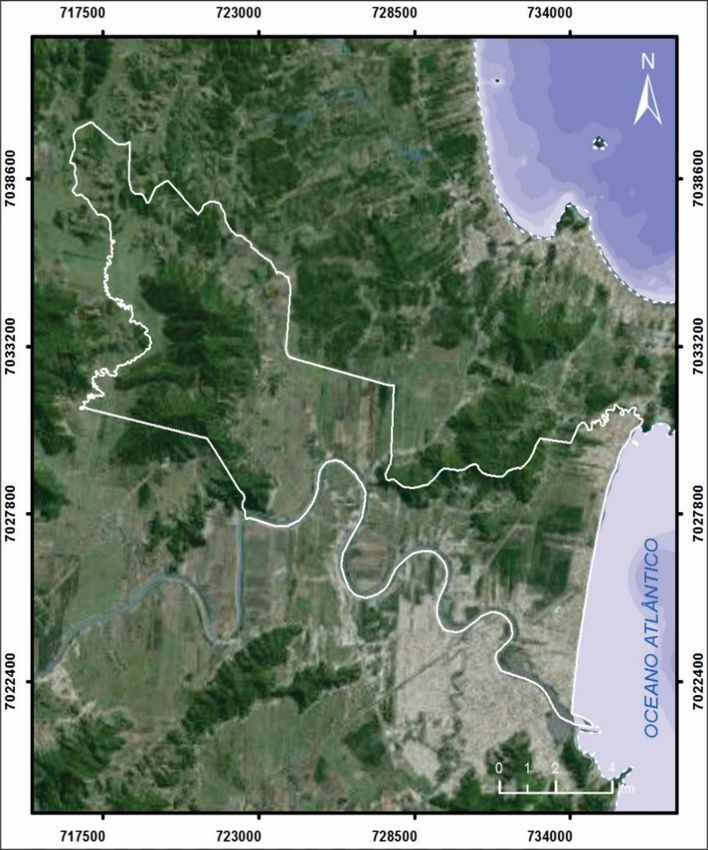
Quaternary and Environmental Geosciences (2021) 12(1):1-17

  The Jurerê beach arch can be subdivided into Jurerê                             According to Felix (2020), the ridge sandy sediments
and Jurerê Internacional beaches, behaves like a semi-                          of the Jurerê coastal plain represents a typical progradant
exposed, parabolic, intermediate to reflective system,                          barrier facies, characterized by the succession of coastal
medium slope of the beach face and composed of fine                             ridges formed by crests (predominantly sandy) and
very well sorted sand (Horn Filho et al. 2020).                                 runnels (sand-silty), deposited in environments of
                                                                                medium high hydrodynamic energy, with a positive
                                                                                sedimentary balance regime over the upper Holocene.

Figure 8: Image showing the approximate limits of the Holocene progradant coastal sandy ridges of Jurerê in the Santa Catarina island, municipality of
Florianópolis on the Central coast of Santa Catarina.

                                                                                                                                                    9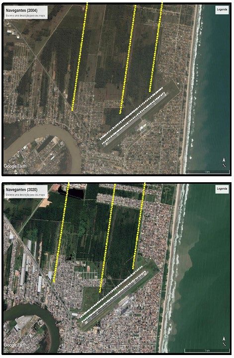
Quaternary and Environmental Geosciences (2021) 12(1):1-17

Figure 9: Images showing the coastal strands of Jurerê on the Central coast of Santa Catarina. The upper image refers to the monochromatic aerial
photograph of the year 1978, scale 1: 25,000 and the lower image of 8/5/2020 from Google Earth. In both images, the ridges aligned parallel to the
current coastline of the Jurerê bay on the island of Santa Catarina (yellow dotted lines) are evident, however, there are still few exposures of these ridges
that have not yet been occupied by urbanization, except south of the area in question.
  Tijucas coastal plain (❹), located in the Central coast                           between 1 and 6 m. Coarse sandy sediments over ridges
of Santa Catarina state (UTMx 6985002,93; UTMy                                      with concentration of bioclast and siliciclastic and
733735,00), municipality of Tijucas, is constituted by                              muddy sediments in runnels characterize a typical
retilineous (slightly curved) and flat ridges presenting 10                         swash-ridges and chenier ridges, whose orientation of
km of length, 5 km of width and altitudes ranging                                   the crests is virtually N-S. The ridges and runnels of the

                                                                                                                                                         10
Quaternary and Environmental Geosciences (2021) 12(1):1-17
coastal plain are occupied at the present time by an sand and mud. Ficus sp is founded over sandy ridges
intensive urbanization adjacent to Tijucas bay, Tijucas parallel to the coastline (Horn Filho et al. 2020).
beach and municipality of Tijucas, only an undeveloped Regarding the Tijucas coastal plain, Asp et al. (2005)
part remains south of the Tijucas river (Figure 10 and and Fitzgerald et al. (2007), Fitzgerald e al. (2011)
Figure 11). The Tijucas beach behaves like a semi- identified the domain of the sandy plain, alternated by
exposed, parabolic, dissipative, low slope of the beach chenier deposits with a considerable increase in muddy
face and composed of fine coarse moderately sorted sedimentation in the most recent portions of the coastal
plain.
Figure 10: Image showing the approximate limits of the Holocene progradant coastal sandy ridges of Tijucas in the municipality of Tijucas on the
Central coast of Santa Catarina.
11Quaternary and Environmental Geosciences (2021) 12(1):1-17
Figure 11: Images showing the plain of coastal regressive ridges (cheniers) of Tijucas on the Central coast of Santa Catarina. The upper image refers to
the monochromatic aerial photograph of the year 1978, scale 1: 25,000 and the lower image of 27/5/2020 from Google Earth. In both images, the ridges
aligned parallel to the current coastline of the Tijucas bay are evident, with the first, closer to the coastline, undergoing inflection due to the presence
of a small rocky basement island (circle yellow) and, the second, is intercepted by a current sedimentation of the Tijucas river floodplain deposit (blue
circle). The dotted yellow lines represent the coastal ridges.
Navegantes coastal plain (❺), located in the Central azimuth 20°. The ridges and runnels of the coastal plain
coast of Santa Catarina state (UTMx 7025636,09; UTMy are occupied at the present time by an intensive
732949,90), municipality of Navegantes, is constituted urbanization adjacent to Navegantes beach, Itajaí-Açú
by retilineous and flat ridges presenting 6 km of length, river and Navegantes municipality, only an undeveloped
2 km of width and altitudes ranging between 1 and 6 m. part remains to the center of the coastal plain (Figure 12
Fine sandy sediments over ridges characterize a typical and Figure 13).
swash-ridges, whose crests are oriented NE-SW with
12Quaternary and Environmental Geosciences (2021) 12(1):1-17
The Navegantes beach currently behaves like an directly exposed to waves of the open sea, being
exposed, retilineous, intermediate to dissipative beach, expressed by the succession of beach ridges interspersed
low slope of the beach face and composed of medium by relatively runnels (10 to 30 m) filled by muddy
coarse well sorted sand (Horn Filho et al. 2020). sedimentation and eolic deposits closest to the current
On the coastal plain of Navegantes, Fitzgerald et al. coastline.
(2007) stated that it is composed of fine sandy sediments
Figure 12: Image showing the approximate limits of the Holocene progradant coastal sandy ridges of Navegantes in the municipality of Navegantes on
the Central coast of Santa Catarina.
13Quaternary and Environmental Geosciences (2021) 12(1):1-17
Figure 13: Images showing the plain of coastal regressive ridges of Navegantes on the Central coast of Santa Catarina. The upper image refers to image
of 20/4/2004 and the lower image of 27/5/2020, from Google Earth. In both images, the ridges aligned parallel to the current coastline of the Navegantes
beach are evident, represented by dotted yellow lines. The landing and takeoff track of Navegantes International Airport cuts across the ridges in the
south of the area (double dotted line in white color).
14Quaternary and Environmental Geosciences (2021) 12(1):1-17
The Holocene beach ridges are constituted by a
succession of crests and runnels, elongated and narrow,
continuous and/or interrupted, orientated parallel to the
actual coastline, exhibiting right-lined and curve-lined
shape. The maximum heights are 3 to 6 m in ridges and
1 to 2 m in runnels. The medium interval between ridges
varies between 25 and 50 m.
Horizontal and slightly inclined cross bedding are
commonly found in these marine deposits. They are
composed by sandy sediments, fine to very fine, sorted
to well-sorted, mature to well-mature, with quartz and
heavy minerals, sub-rounded to rounded, besides of
bioclastics. Due to the humidity, silt-sand-clay
sediments, enriched in organic matter are observed in
the runnels.
Negative skewness and leptokurtic predominate
among the sediments. When covered by eolic sediments
on the crest, they are constituted by fine and medium
sands, with predominant positive skewness and
platicurtic. The shallow origin of the marine deposits is
established by the presence of Callichirus sp that lives
in the sub tidal zone buried on the sand attesting shallow
marine environment typical of foreshore and backshore Figure 14: Evolutionary formation model of the Brazilian coastal
sectors. plains during the Neo-Cenozoic, divided into the following stages: a)
Sedimentation of the Barreiras Formation; b) Maximum of the old
According to the paleogeographical point of view, transgression; c) Sedimentation after the Barreiras Formation; d)
older coastlines located in higher levels are Maximum of the penultimate transgression; e) Construction of
characterized by geological evidences (sedimentologic Pleistocene marine terraces; f) Maximum Holocene transgression; g)
and geomorphologic), biological and archaeological Construction of intralagoon deltas and h) Construction of Holocene
marine terraces (modified by Martin & Suguio 1989).
(shell-middens) (Martin & Suguio 1986).
Martin et al. (1988) stated that the different sea level The deposits of the Holocene ridges of Santa Catarina
fluctuations associated with paleoclimatic modifications coast are associated to regressive phases of Flandrian
are the main environmental factors that led to the transgression, formed during three regressive phases: (i)
creation of Brazilian coastal plains, including the first transgressive-regressive pair, between 5,1 and 3,8
construction of Holocene marine terraces and eventual ky BP, reaching the maximum regressive in 4 ky BP
progradation of the coastline, during the lowering of the with sea level of (–) 2,5 m; (ii) second transgressive-
relative sea level after the maximum transgressive of 5,1 regressive pair, between 3,6 and 3,1 ky BP, reaching the
y BP, situation that fits for the formation of the maximum regressive in 3,1 ky BP with sea level of (–)
progradant coastal ridges in the state of Santa Catarina 2 m and, (iii) third transgressive-regressive pair,
(Figure 14, stage h). between 2,7 ky BP to present, reaching actual sea level
(0 m) (Figure 15).
Figure 15: Relative sea level Holocene curve to the Santa Catarina coast.
sedimentary provenience, sedimentary source, and sea
Conclusions
level changes.
Beach ridges are indicators of clastic transitional The present interpretation of beach ridge description
depositional areas and maybe utilized by studies of applies to supra tidal and intertidal coastal ridges, built
waves regime, climatic conditions, sedimentary supply, by waves, stabilized and remnants, consisting of
15Quaternary and Environmental Geosciences (2021) 12(1):1-17
siliciclastic or bioclastic sediments in a broad range, Buynevich, I.V.; Asp, N.E.; Fitzgerald, D.; Cleary, W.J.; Klein,
A.H.F.; Siegle, E.; Angulo, R. 2005. Mud in the surf: nature at
from fine to coarse sand.
work in a Brazilian bay. EOS Trans., 86(33):301-304.
Before beach ridges get stabilized, transgressive Carter, R.W.G. 1986. The morphodynamics of beach-ridge formation:
ridges have a regressive history (progradational) or Maglligan, Northern Ireland. Mar. Geol., 73:191-214.
transgressive. In the same way, before they can become Davies, J. L. 1958. The importance of cut and fill in the development
of sand beach-ridges. Aust. Jour. Sci., 20:105-111.
stabilized and inactive beach ridges, sub tidal
Davies, J.L.1968. Beach ridges. In: Fairbridge, R. W., (Ed.).
transgressive bioclastic and sandy ridges, frequently Pennsylvania: The Encyclopedia of geomorphology, p.70-71.
displace themselves to the inner continent shelf above Davies, R.A. & Hayes, M.O. 1984. What is a wave-dominate coast?
the tide high level. Mar. Geol., 60:313-329.
Felix, A. 2020. Ambientes de sedimentação e sistemas deposicionais
The history of the evolution of the majority of the do Holoceno costeiro na ilha de Santa Catarina - SC/Brasil.
Holocene beach ridges including those on the coast of Florianópolis. 570p. Tese de doutorado. Programa de Pós-
Santa Catarina have connection to the events of the last graduação em Geografia. Universidade Federal de Santa Catarina
7 ky BP, depending particularly on the surface gradient (no prelo).
Fitzgerald, D.M.; Cleary, W.J.; Buynevich, I.V.; Hein, C J.; Klein,
which suffered the transgressions, on their relative
A.H.F.; Asp, N.E.; Angulo, R.J. 2007. Strandplain evolution
stability, on the intensity of the oceanography agents along the southern coast of Santa Catarina, Brazil. Journal of
that trigger the sediments dispersion, and on the supply Coastal Research, 50:152-156.
rate of sediments. Fitzgerald, D.M.; Hein, C.J.; Cleary, W.; Menezes, J.T.; Klein, A.H.
F.; Scolaro, T.; Buynevich, I.V.; Petsch, S.T. 2011. Climatic and
The progradation of the beach ridges in Santa Catarina sedimentological forcing of strandplain progradation at Tijucas,
state is associated with sedimentation arising from central Santa Catarina, Brazil. In: INTERNATIONAL UNION
marine and aeolian processes. The factors for their FOR QUATERNARY RESEARCH CONGRESS, XVIII, Berna,
origin and stability comprehend constant sediment Proceedings…, Abstract 2791.
Fouch, T.D. & Dean, W.E. 1982. Lacustrine and associated clastic
supply, stable sea level or slow dropping, geological depositional environments. In: SCHOLLE, P.A. (Ed.). Sandstone
inheritance, substrate gradient, sediment source and depositional environments. Am. Assoc. Petroleum Geologists,
fixation by coastal vegetation. 410p.
Sequences of beach ridges are frequent components of Hein, C.J.; Fitzgerald, D.M.; Cleary, W.J.; Albernaz, M.B.; Menezes,
J.T.; Klein, A.H F. 2013. Evidence for a transgressive barrier
Holocene coastal plains. Specific beach ridges may be
within a regressive strandplain system: implications for complex
reasonable indicators of paleo shorelines position and coastal response to environmental change. Sedimentology,
sea levels, and even of climate stages and rates of 60:469-502.
isostatic rising (Mason 1990). Hesp, P.A. 1984. Foredune formation in southeast Australia. In: Thom,
B.G. (Ed.). Coastal geomorphology in Australia, Academic Press,
There is not a clear consensus at the literature about p.69-97.
beach ridge definition. However, the range of terms Hesp, P.A.; Dillenburg, S.R.; Barboza, E.G.; Tomazelli, L.J.; Ayup-
frequently used to beach ridges include marine deposits Zouain, R.N.; Esteves, L.S.; Gruber, N.L.S.; Toldo Júnior, E.E.;
built by waves (intertidal, supra tidal and sub tidal) and Tabajara, L.L.C. de A.; Clerot, L.C.P. 2005. Beach ridges,
foredunes or transgressive dune fields? Definitions and an
winds. Small ridges are normally present in lakes, examination of the Torres to Tramandaí barrier system, southern
lagoons, and bight beaches (Fouch & Dean 1982) Brazil. An. Acad. Bras. Ciênc., 77(3):493-508.
originated by the progradation of the lagoon and oceanic Hogben, N. & Lumb, F.E. 1967. Ocean waves statistics. London:
margins. National Physical Laboratory. Ministry of Technology.
Horn Filho, N.O. 2003. Setorização da província costeira de Santa
Sustainable development will allow the progradant Catarina, em base aos aspectos geológicos, geomorfológicos e
plains preservation on the distinct coastal plains of Santa geográficos. Geosul, 37:45-78.
Catarina state. Continuity of this study should include Horn Filho, N.O. & Diehl, F.L. 1994. Geologia da planície costeira de
sub-surface stratigraphy (coastal coring and C14) and Santa Catarina. Alc., 1(1):95-102.
Horn Filho, N.O; Diehl, F.L. & Amin Jr., A.H. 1996. Quaternary
detailed geological comparative studies.
geology of the Central-northern coastal plain of the Santa Catarina
state, southern Brazil. In: INTERNATIONAL GEOLOGICAL
References CONGRESS, 30, Abstracts... Beijing: IUGS, p.202.
Horn Filho, N.O.; Gré, J.C.R.; Klingebiel, A. 1995. Evolution
Adams, K.D. & Wesnousky, S.G. 1998. Shoreline processes and the Holocene de la plaine cotiere de L’État de Santa Catarina (Brésil):
age of the lake Lahontan highstand in the Jessup embayment, caracterisation morphologique et sedimentologique de la
Nevada. GSA Bulletin, 110:1318-1332. progradación des cordons littoraux. In: BORDOMER -
Angulo, R.J. 1992. Geologia da planície costeira do estado do Paraná. COASTAL CHANGE 95, Bordeaux, Résumés... p.979-980.
São Paulo. 334p. Tese de doutorado. Programa de Pós-graduação Horn Filho, N.O.; Abreu de Castilhos, J.; Gré, J.C.R.; Diehl, F.L.
em Geociências. Universidade de São Paulo. 1994. The coastal Pleistocene of the Santa Catarina state,
Asp, N.E.; Buynevich, I.V.; Siegle, E.; Fitzgerald, D.M.; Klein, Southern Brazil - geological aspects. In: INTERNATIONAL
A.H.F.; Cleary, W.C.; Angulo, R.J. Coastal geomorphology of the GEOLOGICAL CORRELATION PROGRAM 253 - THE
Tijucas plain - Brazil: preliminar evolutionary model. In: TERMINATION OF THE PLEISTOCENE IN SOUTH
CONGRESSO DA ASSOCIAÇÃO BRASILEIRA DE AMERICA, Abstracts... Ushuaia, p.9-10.
ESTUDOS DO QUATERNÁRIO, X, Guarapari, Anais..., 6p. Horn Filho, N. O.; Schmidt, A. D.; Estevam, C. N.; Oliveira, U. R.
Bates, R.L. & Jackson, J.A. 1980. Glossary of geology. 2a Ed. de. 2020. Atlas geológico-oceanográfico das praias arenosas
American Geological Institute. 751p. oceânicas de Santa Catarina, Brasil. Universidade Federal de
Bird, E.C.F. 1960. The formation of sand beach ridges. Aust. Jour. Santa Catarina, Centro de Filosofia e Ciências Humanas,
Sci., 22:349-350. Departamento de Geociências, Programa de Pós-graduação em
Butler, R.W. 1980. The concept a tourist area cycle of evolution: Geografia. Florianópolis: Edições do Bosque
implications for management of resources. University of Western (NUPPE/CFH/UFSC) (no prelo).
Ontario Canadian Geographer, XXIV, 1:5-12. Johnson, D.W. 1919. Shore processes and shoreline development.
New York: Hafner Publishing, 584p.
16Quaternary and Environmental Geosciences (2021) 12(1):1-17
Lacerda, L.D.; Araujo, D.S.D; Cerqueira, R.; Turcq, B. 1984. Redman, J.B. 1864. The east coast between the Thames and the Wash
Restingas: origem, estrutura, processos. Niterói: CEUFF. 477p. estuaries. Proceedings Institution of Civil Engineers, v.23, p.186-
Martin, L. & Suguio, K. 1986. Coastal Quaternary deposits of the 257.
states of Paraná and Santa Catarina. In: INTERNATIONAL Schwarz, M.L. 1971. The multiple causality of barrier islands. Jour.
SYMPOSIUM ON SEA LEVEL CHANGES AND Geol, 79:91-94.
QUATERNARY SHORELINES. São Paulo, 124p. Short, A.D. 1984. Beach and nearshore facies: southeast Australia.
Martin, L. & Suguio, K. 1989. Excursion route along the Brazilian Mar. Geol., 60:261-282.
coast between Santos (state of São Paulo) and Campos (north of Smith, R.A. 1991. Beach resorts: a model of development evolution.
state of Rio de Janeiro). In: INTERNATIONAL SYMPOSIUM Landscape and urban planning, 21:189-210.
ON GLOBAL CHANGES IN SOUTH AMÉRICA DURING Stapor, F.W. 1982. Beach ridges and beach ridges coasts. In:
THE QUATERNARY. São Paulo: Associação Brasileira de SCHWARTZ, M.L. (Ed.). The Encyclopedia of beaches and
Estudos do Quaternário - ABEQUA, Special Publication n°2; coastal environments. Pennsylvania: Hutchinson Ross Publishing
136p. il. Company, p.160-161.
Martin, L.; Suguio, K.; Flexor, J.M.; Azevedo, A.E.G. de. 1988. Texto Stapor, F.W.; Mathews, T.D. & Lindfors-Kearns, F.E. 1988. Episodic
explicativo do mapa geológico do Quaternário costeiro dos barrier island growth in south-west Florida: a response to
estados do Paraná e Santa Catarina. Brasília: Departamento fluctuating Holocene sea level? Geol. Soc. Mem., 3:149-202.
Nacional de Produção Mineral - DNPM, 1988. n°28; 31p. il. 1 Suguio, K. 1992. Dicionário de geologia marinha (com termos
mapa. correspondentes em inglês, francês e espanhol). São Paulo: T.A.
Mason, O.K. 1990. Beach ridge geomorphology of Kotzebue sound: Queiroz, 172p.
implications or paleoclimatology and archeology. 262p. PhD Tanner, W.C. 1987. Spatial and temporal factors controlling
Thesis. University of Alaska. overtopping of coastal ridges. In: Singh, P.V. (ED.). Flood
Mudat, J.E., Melo, A.T., Ribeiro, D., Souza, D.R., Neves, J., DI Pietro Hydrology. D. Reidel Publishing Co., Dordrecht, p.241-248.
Filho, J.E., Kitahara, M.V., Horn Filho, N.O., Oliveira, U.R. 2006. Tanner, W.F. 1992. 3000 years of sea level change. Bul. Amer.
Geologia e geomorfologia costeira da folha Sombrio, SC. In: Meteor. Soc., 73(3):297-303.
SIMPÓSIO NACIONAL DE GOMORFOLOGIA/REGIONAL Tanner, W.F & Demirpolat, S. 1988. New beach ridge type: severely
CONFERENCE ON GEOMORPHOLOGY, IV. Anais...Goiânia, limited fetch shallow water. Trans., 38:367-373.
p.1-13. Taylor, M.J. & Stone, G.W. 1996. Beach-ridges: a review. Jour. Coas.
Otvos, E.G. 2000. Beach ridges - definitions and significance. Res, 12:612-621.
Geomorphology, 32:83-108. Thom, B.G. 1964. Origin of sand beach-ridges. Austr. Journ. Sci.,
Polette, M. 1993. Planície do Perequê/ilha de São Sebastião - 26:351-355.
diagnóstico e planejamento ambiental costeiro. São Carlos. 136p. Villwock, J.A. 1972. Contribuição à geologia do Holoceno da
Dissertação de mestrado. Programa de Pós-Graduação em província costeira do Rio Grande do Sul, Brasil. Porto Alegre.
Ecologia e Recursos Naturais, Universidade Federal de São 133p. Dissertação de Mestrado de Geociências. Instituto de
Carlos. Geociências. Universidade Federal do Rio Grande do Sul.
Redman, J.B. 1852. On the alluvial formations and the local changes Villwock, J.A.; Tomazelli, L.J.; Loss, E.L. Dehnhardt, E.A.; Horn
of the south coast of England. Proceedings Institution of Civil Filho, N.O.; Bachi, F.A.; Dehnhardt, B.A. 1986. Geology of the
Engineers, v.11, p.162-223. Rio Grande do Sul coastal province. Quat. Sou. Amer. Ant. Pen.,
4. i
i
Recebido 28 de agosto de 2020
Aceito 19 de fevereiro de 2021
17You can also read