Coastal Karst Groundwater in the Mediterranean: A Resource to Be Preferably Exploited Onshore, Not from Karst Submarine Springs - MDPI
←
→
Page content transcription
If your browser does not render page correctly, please read the page content below
geosciences
Review
Coastal Karst Groundwater in the Mediterranean:
A Resource to Be Preferably Exploited Onshore,
Not from Karst Submarine Springs
Michel Bakalowicz
 HydroSciences, Université de Montpellier, CC57, 34090 Montpellier, France; michel.bakalowicz@gmail.com

 Received: 21 May 2018; Accepted: 4 July 2018; Published: 11 July 2018

 Abstract: Coastal karst aquifers are common in the Mediterranean basin. With their significant
 potential storage capacity, they are an attractive groundwater resource in areas where the water
 demand is the most important. They discharge either at the coastal zone or directly into the sea at karst
 submarine springs (KSMS). Decision makers take an interest in this unconventional groundwater
 resource and are convinced by companies and research consultancies that KSMS’s should be
 exploited because they would discharge huge amount of fresh water. Being now well documented,
 the occurrence of KSMS’s along the Mediterranean coast is discussed in the light of recent geological
 history favourable to the development of karst. Conduit flow conditions are common, inherited from
 an intense phase of karstification during the Messinian Crisis of Salinity at the end of Miocene,
 when the sea level was 1500 to 2500 m below present sea level. From investigations carried out
 along the coasts of France and the Levant, compared with studies done along other Mediterranean
 coastlines, it appears that capturing groundwater discharged at KSMS raises different problems
 which make the operation dicey and expansive.

 Keywords: coastal karst aquifer; submarine spring; Mediterranean; groundwater resources;
 exploitation

1. Introduction
      According to UN data [1–3], water resources in countries of the Mediterranean basin are limited
and unevenly shared out. The southern countries have only 13% of the total. By the year 2025,
five countries (Egypt, Lebanon, Morocco, Syria and Turkey) among 21 will get less than 1000 m3
per person per year, what means that their economic development will be impacted. For five others
(Algeria, Israel, Libya, Malta and Tunisia) the water resource will be below 500 m3 /year, what will
be a drastic constraint for life. The population growth and the economic development strongly
weigh on water resources, what jeopardizes the public health and the environment conservation.
Water uses, shared between agriculture (67%), water supply (21%) and industry (12%) are more
and more competing [4], what leads to conflicts for sharing water resources. The situation will get
worse because most of the population will live along the coasts and the climate change will impact
water resource.
      Consequently, this severe water scarcity in the Mediterranean basin forecast at short term
encourages the authorities to find solutions for meeting the demand. One of these solutions is
to look for new water resources, known as unconventional. One of them is related to submarine
groundwater discharge, which is particularly common along the Mediterranean coastline. Since the
20000 s several private European companies were created with the object of capturing fresh water
discharged at submarine springs, in order to sell it to local authorities for water supply. At first glance,
it looked a very interesting resource to be exploited, because in the 1960s and 1970s several papers

Geosciences 2018, 8, 258; doi:10.3390/geosciences8070258                   www.mdpi.com/journal/geosciences
Geosciences
Geosciences 2018,
2018, 8, x FOR PEER REVIEW
8, 258 2 of212
of 12
papers and reports forecast huge flow rates, sometimes of several millions m3 per day of fresh
water
and [5,6].forecast
reports Recent huge
advances
flowinrates,
submarine worksofallow
sometimes considering
several millions capturing
m3 per day this
ofunconventional
fresh water [5,6].
resource
Recent whichin could
advances be a works
submarine seriousallow
challenge to desalination
considering and unconventional
capturing this treated waste water reuse.
resource which
Investigations
could be a serious carried out during
challenge the last 20and
to desalination years on Mediterranean
treated karst coastal
waste water reuse. aquiferscarried
Investigations and
outsubmarine
during the springs
last 20allow
years discussing the possibility
on Mediterranean of capturing
karst coastal karst
aquifers and submarine
submarinesprings
springsand
allow
proposing
discussing thealternative approaches.
possibility of capturing karst submarine springs and proposing alternative approaches.
2. Diffuse
2. Diffuse Versus
Versus ConcentratedSubmarine
Concentrated SubmarineGroundwater
Groundwater Discharge
Discharge
Mostofofthe
Most the coastal
coastal aquifers
aquifersdischarge
dischargeat least a part
at least of their
a part of resource directlydirectly
their resource into the into
sea. Many
the sea.
researchers study submarine groundwater discharge (SGD), because this is a contribution
Many researchers study submarine groundwater discharge (SGD), because this is a contribution to to aquatic
biodiversity
aquatic [7] as[7]
biodiversity well as anasunknown
as well partpart
an unknown of the groundwater
of the groundwater balance.
balance. However,
However, most works
most works
consider only diffuse SGD from porous or fissure aquifers because this is the most common SGDSGD
consider only diffuse SGD from porous or fissure aquifers because this is the most common along
along the world’s coasts.
the world’s coasts.
A global assessment [8] showed that concentrated SGD’s occur along coastal volcanic and karst
A global assessment [8] showed that concentrated SGD’s occur along coastal volcanic and karst
aquifers. Among them, karst submarine springs (KSMS) are the most common and are known
aquifers. Among them, karst submarine springs (KSMS) are the most common and are known
everywhere offshore carbonate rock formations, especially along the coasts of Florida (see e.g., [9,10])
everywhere offshore carbonate rock formations, especially along the coasts of Florida (see e.g., [9,10])
and of Yucatan [11,12]. However according to [8], more than 90% of them occur along the
and of Yucatan [11,12]. However according to [8], more than 90% of them occur along the Mediterranean
Mediterranean coasts (Figure 1) where the most spectacular ones are described. They are related to
coasts (Figureformations
carbonate 1) where thewhich
most spectacular
outcrop all ones are described.
around They are related
the Mediterranean, up toto500,000
carbonate
kmformations
2 of the
which outcrop all around the Mediterranean, up to 500,000 km 2 of the Mediterranean watershed [13].
Mediterranean watershed [13]. We will discuss below why KSMS are mainly concentrated along the
WeMediterranean
will discuss below
coasts.why KSMS are mainly concentrated along the Mediterranean coasts.
Figure 1. Schematic map of karst areas around the Mediterranean with the location of the main
Figure 1. Schematic map of karst areas around the Mediterranean with the location of the main known
known karst submarine springs (adapted from [14]). The three main remaining hypersaline basins at
karst submarine springs (adapted from [14]). The three main remaining hypersaline basins at the
the Messinian low stage are shown in pink with the main post-Messinian fluvial fans in grey
Messinian low stage are shown in pink with the main post-Messinian fluvial fans in grey (adapted
(adapted from [15]).
from [15]).
Mediterranean karst aquifers provide essential water resources at the origin of ancient
civilizations, having
Mediterranean enabled
karst theprovide
aquifers settlements and the
essential development
water resources atofthe
numerous
origin of cities,
ancient linked with
civilizations,
the technology
having enabled theforsettlements
exploiting the
andwater resources. Presently,
the development the main
of numerous development
cities, linked withoccurs along thefor
the technology
coasts, what
exploiting meansresources.
the water that they are put under
Presently, thepressure by risks of overexploitation,
main development occurs along thesea waterwhat
coasts, intrusion
means
and pollution. All the means must be implemented in order to avoid a major water
that they are put under pressure by risks of overexploitation, sea water intrusion and pollution. Allcrisis, all thethe
more so since karst aquifers are very complex, unpredictable and consequently particularly
means must be implemented in order to avoid a major water crisis, all the more so since karst aquifers difficult
aretovery
manage and protect
complex, [16].
unpredictable and consequently particularly difficult to manage and protect [16].
During the last decades, several European projects focused on karst management and protection,
in particular COST 65 [17], COST 620 [18], COST 621 [19,20]] and. All of them attempted to summarize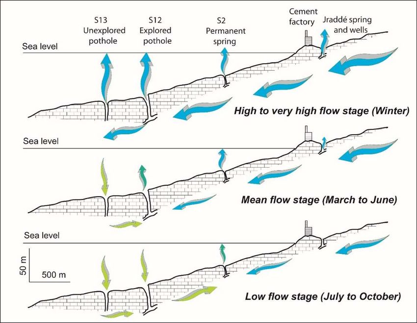
Geosciences 2018, 8, 258                                                                            3 of 12

the major points of knowledge, techniques and gaps concerning the karst groundwater resources in
all the Mediterranean countries. Concerning coastal karst aquifers, the lack of data and geological
knowledge was the main obstacle. Mijatovic [21] made a first approach, however, using the results
of old field studies based on dated concepts and geological knowledge. All these karst aquifers
underwent a complex, recent geological evolution, driven by tectonics with uplifts and subsidences.
They all undergo to a typical climate with two opposite hydrological seasons, the humid one, short and
severe; the dry one, very long and warm. These conditions of development of karst in carbonate
formations are shared with all carbonate rocks around the world [22]. Nevertheless, the Mediterranean
karst aquifers and especially the coastal ones were subject to a particular geological event which made
them very different from other world’s karst aquifers.

3. The Messinian Crisis of Salinity, A Major Geological Event
      Until the end of the last century, it was considered that KSMS’s were inherited from the last
glaciation when the global ocean level was 130 m below the present sea level [21]. This particular
situation for the Mediterranean basin cannot explain the occurrence of KSMS’s much more frequent in
the Mediterranean basin than elsewhere in the world. Moreover, some of them discharge the most
important known flow rate according to several evaluations [6,21].
      In fact, since the 19700 s geological investigations showed that the Mediterranean basin was subject
to a special event at the end of Miocene, the Messinian crisis. It was definitely understood and accepted
that this crisis was the consequence of the closure of the strait between the Atlantic Ocean and the
Mediterranean Sea caused by the northward movement of the African plate occurring at the end of
Miocene around 6 Ma and probably during similar events during upper Miocene [23]. The isolation
of the basin was followed by a radical change in its water budget, because the fresh water inflow
was—and is still—lower than the evaporation. Before the closure, the difference was offset by an
inflow of Atlantic water, as it occurs presently. Without this inflow, the sea level decreased in the same
way as presently in the Dead Sea basin. At the maximum of desiccation there was only three remaining
hypersaline basins and large evaporite deposits everywhere (Figure 1). For that reason, this major
event is named the Messinian Crisis of Salinity (MCS).
      Beginning at 7.2 Ma, the MCS was first a long sea level decreasing up to 1500–2500 m below
the present sea level (b.s.l.), depending on the basins. The minimum was reached around 6.8 Ma
and lasted about 500,000 years. The main river valleys were forced to deeply entrench the continent
and groundwater invaded carbonate rocks, developing karst at depth and reaching very low base
levels, generally at the bottom of the carbonate formations. The erosion along the river valleys and
the emptying of the basin as well as its flooding at the end of the MCS caused isostatic responses [24],
fracturing rocks and increasing the relief. All these geological events strongly contributed to favour
the development of karst. Rias and rocky inlets—named “calanques” in French—were created during
this phase of erosion. Huge karst springs discharged at the foot of carbonate formations developing
pocket valleys as shown by investigations along the French coast [25] and now completely plugged
with Pliocene and Quaternary formations.
      The MCS ended with the opening of the strait of Gibraltar around 5.3 Ma. The basin and the river
valleys were then flooded probably in less than 30 years [26]. For instance, the Nile River valley was
flooded up to Aswan; and the Rhone River valley up to Lyon. The main rivers supplied a huge clayey
sedimentation, the Pliocene (Zanclean) marine blue clays crowned with deltaic and alluvial formations,
the Pliocene and Quaternary detrital sediments known as Villafranchian in the South of France.

4. Main Consequences on Karst Aquifers
     In areas where the impermeable marine sediments occur, for instance along the Rhone River
valley, the Messinian karst systems were blocked in their downstream part and flooded with fresh
water still recharging them. The mains consequences are as follows: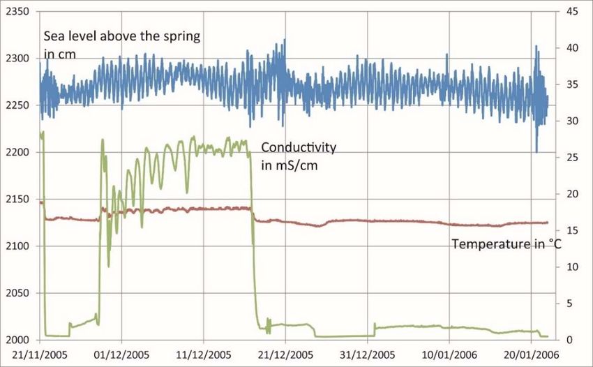
Geosciences 2018, 8, 258                                                                             4 of 12

•     The widening of the recharge area, caused by the connections between adjoining Messinian karst
      systems, created during the Pliocene flooding. The Vaucluse spring karst system is the best-known
      example [27]. These karst systems offer a large groundwater resource.
•     The increasing of the storage capacity because of the development of karst features at depth
      during the MCS, creating often huge reserves of groundwater, in the same way as it occurs in
      intracontinental basins [28].
     However, the Pliocene marine clays are not present far from the most important estuaries.
Therefore, Messinian surface features are flooded but not fossilized by thick impermeable sediments.
In areas where carbonate rocks are predominant, surface karst features such as dolines, sinkholes,
dry valleys and karrens are directly open to the sea, what allows sea water to inflow into or fresh water
to outflow from conduits and open fractures, according to the water head relationship between sea
water and fresh water in the conduits. The main consequences are as follows:
•     The occurrence of KSMS’s, due to groundwater discharge from flooded karst features, sometimes far
      from the coastline.
•     The natural inflow of sea water into karst aquifers from flooded karst features, what is the cause
      for inland brackish springs such as Fontestramar in France [29] or Almyros of Heraklion in
      Crete [30].
     According to this situation and because the karst conduits are not plugged, the coastal karst
systems present a typical karst functioning, with large hydraulic variations, increased by the strongly
contrasted Mediterranean climate. During the rainy season, the high flow produces high fresh water
heads in conduits and as a consequence the discharge at seasonal KSMS. During the dry season,
low flow and low fresh water heads are prevailing, what results in sea water intrusion into the conduits
and as a consequence a low discharge of frequently brackish water.
     However, compared to continental karst systems, the functioning of these coastal karst aquifers
is quite different because their outlets are not the natural outlets where the conduit system
ended originally. The present outlets are either ancient surface features initially acting as input
points—swallow hole, abandoned cave, pothole—or fractures progressively enlarged by solution since
the flooding of the lower part of the system. This situation creates new conditions for conduit flow,
with local high head losses that favour the functioning of seasonal KSMS at greater depths.

5. A Case Study: The Chekka Karst Aquifer and Its KSMS’s
      Along the northern coast of Lebanon, the Chekka karst system was considered for discharging
the highest flow rate directly into the sea from several KSMS [5,21]. For that reason, it was studied by
El-Hajj [31] for his Ph.D. under my supervision. This is presently a well-studied example of coastal
karst aquifer with several permanent and seasonal KSMS’s. The coastal part of this 250-km2 karst
system is shown Figure 2.
      The nahr El Asfour River presents a seasonal flow fed in its downstream part by surface flow on
the thick, impermeable chalky Senonian marl. The surface water is diffusely swallowed in the narrow
valley. However, in its upstream course the river is swallowed at several locations as well as another
river located at South, the nahr El Jawz River. These point recharges and the diffuse infiltration into
the Cenomanian and Turonian limestone composes the recharge area of the Chekka karst system,
discharging in the Chekka Bay.
      The discharge system (Figure 2) is composed of several small permanent coastal springs (S7 and
S8), a group of permanent submarine springs, S2, S3 and S5, around 22 m b.s.l., all discharging brackish
water a part of the year and several seasonal springs functioning only during floods, onshore (blue
stars, Figure 2) and offshore (S6, S12 and S13) up to 110 m b.s.l., discharging fresh water. The geological
conditions are different from what was described by [5,21] who considered that the carbonate aquifer
is confined by an impermeable formation, the Senonian marls, protecting groundwater from sea
water intrusion. In fact, as shown by submarine geological investigations, the submarine part of the
Geosciences 2018, 8, 258 5 of 12
carbonate aquifer developed in the Cenomanian and Turonian limestone is not protected by the marls
whichGeosciences 2018, 8, x along
were eroded FOR PEER
theREVIEW
valley before its submersion, that is, the Asfour paleovalley 5(Figure of 12 2).
The bottom of the paleovalley is lined by karstic features such as close depressions and the deep
Asfour paleovalley (Figure 2). The bottom of the paleovalley is lined by karstic features such as close
pothole S12 opening
depressions and the at deep
60 mpothole
b.s.l. with its bottom
S12 opening atm
at 60 110 m with
b.s.l. b.s.l.,itswhere a at
bottom large
110 unexplored conduit
m b.s.l., where a
opens. Another submerged pothole S13 remains unexplored.
large unexplored conduit opens. Another submerged pothole S13 remains unexplored.
Figure 2. Hydrogeological settings of the Chekka submarine springs. Karst submarine springs
Figure 2. Hydrogeological settings of the Chekka submarine springs. Karst submarine springs (KSMS)
(KSMS) (red stars) S6, S12 and S13 are seasonal; S2, S3, S5, S7 and S8 are permanent; other small
(red stars) S6, S12 and S13 are seasonal; S2, S3, S5, S7 and S8 are permanent; other small onshore springs
onshore springs (blue stars) generally discharge brackish water.
(blue stars) generally discharge brackish water.
The cross section (Figure 3) shows the functioning of the KSMS’s in different hydrological
conditions:
The cross section (Figure 3) shows the functioning of the KSMS’s in different hydrological conditions:
• the very
very
the highhigh
flowflow stage,
stage, whenwhen S13
S13 andS12
and S12discharge
discharge fresh
fresh water,
water, that
thatis,
is,when
whenthe
thewater
waterhead
head in
in the conduits is maximal;
the conduits is maximal;
the mean flow stage, when the group of permanent KSMS’s only works, probably with some
• the mean flow stage, when the group of permanent KSMS’s only works, probably with some
discharge of brackish water at S12;
discharge
the lowofflow
brackish
stage, water at S12;
occurring during summer and autumn.
• the low flow stage, occurring during summer and autumn.
The permanent submarine springs S2 and S3 were tapped for measuring the flow rate, the
temperature
The permanentand the salinity of springs
submarine the groundwater
S2 anddischarged
S3 were directly
tapped intofor the sea. Whenthe
measuring Kareh flow[5] rate,
estimated the low flow rate to about 2 m 3/s of supposed fresh water, El-Hajj [31] measured only
the temperature and the salinity of the groundwater discharged directly into the sea. When Kareh [5]
aroundthe
estimated 0.1low
m3/s flow
of brackish
rate towater
aboutat 35%
2 mof
3 /ssea
ofwater. Duringfresh
supposed the 2007 dry El-Hajj
water, season—June to October only
[31] measured
—the total flow rate varied in the range 25–35 L/s, depending mainly on the sea level, when the
around 0.1 m3 /s of brackish water at 35% of sea water. During the 2007 dry season—June to October
salinity varied between 33 and 36 mS/cm (50 to 80% of sea water), indicating a fresh groundwater
—the total flow rate varied in the range 25–35 L/s, depending mainly on the sea level, when the salinity
discharge between 10 and 15 L/s.
varied between 33 and 36 mS/cm (50 to 80% of sea water), indicating a fresh groundwater discharge
The seasonal variation of the conductivity of the water discharged at S2 (Figure 4) shows almost
between 10 and 15abrupt
instantaneous L/s. change while the groundwater head in the conduits varies quietly. It means
that when the water head
The seasonal variation reaches
of the a threshold
conductivity of value, water
the water flows backatinS2the
discharged lower4)part
(Figure showsof thealmost
discharge system, either swallowing sea water—the conductivity increases, or discharging fresh
instantaneous abrupt change while the groundwater head in the conduits varies quietly. It means
groundwater—the
that when the water conductivity
head reaches decreases. This isvalue,
a threshold typical water
of conduit flowback
flows conditions,
in thethat is, ofpart
lower a well of the
karstified
discharge aquifer.
system, either swallowing sea water—the conductivity increases, or discharging fresh
groundwater—the conductivity decreases. This is typical of conduit flow conditions, that is, of a well
karstified aquifer.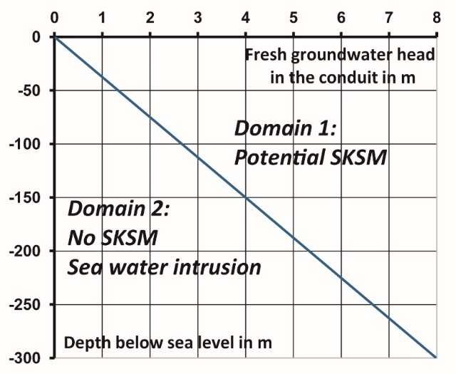
Geosciences 2018, 8, 258                                                                                           6 of 12
Geosciences 2018, 8, x FOR PEER REVIEW                                                                            6 of 12
   Geosciences 2018, 8, x FOR PEER REVIEW                                                                      6 of 12

        Figure 3. Cross section along the Nahr el Asfour River paleo-valley, North Lebanon. The Chekka
     Figure 3.
     Figure     Cross section
             3. Cross  section  along the
                                along  the  Nahr
                                            Nahr el
                                                  el Asfour
                                                     Asfour   River
                                                              River paleo-valley,   North  Lebanon.  The
                                                                                                     The Chekka
        submarine   springs  discharge   groundwater    of a 250 kmpaleo-valley,
                                                                     2 recharge areaNorth  Lebanon.
                                                                                       in Mount   Lebanon.Chekka
                                                                                                            The
                                                                2 recharge area in Mount Lebanon. The deepest
     submarine
     submarine   springs
                  springsdischarge
                           discharge groundwater
                                       groundwater  of a
                                                       of250
                                                           a km
                                                             250  km  2 recharge area in Mount Lebanon. The
        deepest flooded karst features swallow sea water during low flow stage. The permanent spring S2
     flooded karst features swallow sea water during low flow stage. The permanent spring S2 discharges
     deepest  flooded
        discharges     karst water
                    brackish  features  swallowfrom
                                    (modified     sea [31]).
                                                       waterBlue
                                                              during  low flow
                                                                  arrows:  fresh stage.
                                                                                 water The
                                                                                        flow;permanent  spring
                                                                                              green arrows: sea S2
     brackish  water  (modified   from brackish
                                         [31]). Blue arrows: fresh water flow; green arrows: sea water flow;
     discharges   brackish
        water flow;         water
                    blue green     (modified from
                                arrows:               [31]). Blue arrows: fresh water flow; green arrows: sea
                                                  water.
     blue green arrows: brackish water.
     water flow; blue green arrows: brackish water.

        Figure 4. Seasonal variation of conductivity and temperature at S2, compared to sea level. During
        floods at the end of November and after December 21, the conductivity is low, indicating no sea
        water4.intrusion.
     Figure      SeasonalAt the beginning
                           variation        of December,
                                      of conductivity  andthe flow regimeat
                                                            temperature   not modified
                                                                            S2, compared by floods
                                                                                              to seaislevel.
                                                                                                        obviously
                                                                                                             During
     Figure 4. Seasonal variation of conductivity and temperature at S2, compared to sea level. During floods
        influenced  by sea water  intrusion occurring in S12  and S13. Therefore, the effect of
     floods at the end of November and after December 21, the conductivity is low, indicating notide controls thesea
     at the end of November and after December 21, the conductivity is low, indicating no sea water intrusion.
        conductivity.
     water intrusion. At the beginning of December, the flow regime not modified by floods is obviously
     At the beginning of December, the flow regime not modified by floods is obviously influenced by sea
     influenced by sea water intrusion occurring in S12 and S13. Therefore, the effect of tide controls the
     water intrusion occurring in S12 and S13. Therefore, the effect of tide controls the conductivity.
     conductivity.
Geosciences 2018, 8, 258 7 of 12
Geosciences 2018, 8, x FOR PEER REVIEW 7 of 12
6. The
6. The Mechanism
Mechanism of of Natural
Natural Sea
Sea Water
WaterIntrusion
IntrusionininCoastal
CoastalKarst
KarstAquifers
Aquifers
These hydraulic
These hydraulicconditions
conditionsareare driven
driven by by (1) difference
(1) the the difference in water
in water density
density between
between fresh
fresh water
water and sea water and (2) the fresh water head in the conduits and the sea water
and sea water and (2) the fresh water head in the conduits and the sea water level. Considering the sea level.
Consideringwater
water–fresh the sea water–fresh
relationships waterbyrelationships
studied studied by
Ghyben and Herzberg Ghyben
[32], and possible
it becomes Herzberg to [32],
defineit
becomes
two possible
domains to define
separated two
by the domains
line separated
of density by thebetween
equilibrium line of density equilibrium
fresh water between
hfw and sea waterfresh
hsw :
water hfw and sea water hsw:
hhfw = 1.025 h sw
fw = 1.025 hsw
(1)
(1)
In domain
In domain1 1(Figure
(Figure 5) the
5) the hydraulic
hydraulic headhead inconduit
in the the conduit
is highisenough
high enough to overcome
to overcome the
the column
column of sea water and to flow out from any void open to the sea, creating
of sea water and to flow out from any void open to the sea, creating a KSMS, what is impossible ina KSMS, what is
impossible
domain in domain
2. For instance,2.for
Fora instance, for a conduit
conduit discharging dischargingatgroundwater
groundwater at 100
100 m b.s.l., the m b.s.l.,
fresh waterthe fresh
head in
water
the head must
conduit in thebeconduit
at leastmust
2.5 mbe at least
above 2.5 mtoabove
sea level sea level
discharge freshtogroundwater.
discharge fresh groundwater.
These values are
These values arebecause
underestimated underestimated because
the head losses in the
the head losses
conduits areinneglected.
the conduits are neglected.
Figure5.
Figure 5. Diagram
Diagram showing
showing the
the depth
depth below
below sea
sea level
level at
at which
which aa KSMS
KSMS may
may discharge,
discharge,depending
dependingon
on
thefresh
the freshwater
waterhead
headin
inthe
theconduit
conduitdischarging
dischargingatatthe
thespring.
spring.
According to
According to the
the lowest
lowest water
water head head in in the
the conduit
conduit during
during the the year,
year, thethe KSMS
KSMS discharges
discharges
groundwater permanently
groundwater permanently or or only
onlyseasonally.
seasonally.Equation
Equation (1)(1)
says also
says thatthat
also in domain
in domain 2 sea2 water may
sea water
be swallowed in open conduits or fissures, because the sea water head is
may be swallowed in open conduits or fissures, because the sea water head is higher than the fresh higher than the fresh water
head. head.
water Then aThen
seasonal KSMS KSMS
a seasonal generally works works
generally as a “swallow
as a “swallow hole” hole”
swallowing sea water
swallowing when
sea water
groundwater
when head is
groundwater low,is that
head low, is,
thattheis,representative
the representative pointpointis located in domain
is located in domain 2 of 2Figure 5. For
of Figure 5.
instance, a seasonal KSMS located at 50 m b.s.l. means that the fresh water
For instance, a seasonal KSMS located at 50 m b.s.l. means that the fresh water head in the conduit is head in the conduit is less
thanthan
less 1 m,1what is common
m, what is common in karst conduits
in karst where
conduits the hydraulic
where the hydraulic gradient is very
gradient lowlow
is very during the low
during the
stage. Contrarily to what some authors thought (see [8]), it is not necessary
low stage. Contrarily to what some authors thought (see [8]), it is not necessary to invoke a special to invoke a special shape
of the of
shape conduit such as
the conduit a Venturi
such to explain
as a Venturi the natural
to explain intrusion
the natural of seaofwater.
intrusion sea water.
As shown
As shown byby many
many studies,
studies, the
the natural
natural seasea water
water intrusion
intrusion is is typical
typical ofof the
the functioning
functioning of of many
many
coastal karst aquifers. The sea water intrusion is due to (1) the presence of surface
coastal karst aquifers. The sea water intrusion is due to (1) the presence of surface karst features now karst features now
flooded and not plugged by impermeable sediments, (2) conduit flow
flooded and not plugged by impermeable sediments, (2) conduit flow conditions and (3) changes in conditions and (3) changes in
thewater
the waterhead
headinside
insidethetheconduits
conduitsand andinin the
the seasea level.
level. The The natural
natural intrusion
intrusion is obviously
is obviously increased
increased by
by onshore pumping, which decreases the water head in the conduits.
onshore pumping, which decreases the water head in the conduits. The sea water intrusion may occurThe sea water intrusion may
occur sometimes
sometimes severalseveral kilometres
kilometres awayaway fromfrom the coastline
the coastline and and at great
at great depth
depth belowbelowseasea level
level [33,34].
[33,34].
7. The
7. The Issue
Issue of
of Offshore
Offshore Fresh
FreshGroundwater
GroundwaterCapturing
Capturing
At Port-Miou,
At Port-Miou, aa “calanque”
“calanque” near
near Marseille,
Marseille, France,
France, where
where aa large
large flooded
flooded conduit
conduit discharges
discharges
brackish water
brackish water atat around
around 10
10 m
m b.s.l.,
b.s.l., as
as well
well as
asat
atFontestramar
Fontestramar near
near Perpignan,
Perpignan, France,
France, two
two main
main
brackish coastal karst springs, the origin of salts was first assumed to be due to local geological
brackish coastal karst springs, the origin of salts was first assumed to be due to local geological settings,
settings, for instance the presence of Triassic evaporates known in the presumed recharge area. ThisGeosciences 2018, 8, 258 8 of 12
for instance the presence of Triassic evaporates known in the presumed recharge area. This assumption
was abandoned with the development of isotopic and geochemical analyses which showed the marine
origin of the salinity.
The capture of a KSMS was then attempted in the 1960’s by increasing the water head in the
conduit in order to decrease the salinity. The most famous experiment was done at Port-Miou [35] by
the French Geological Survey (BRGM) together with the Marseille Water Company (Eaux de Marseille).
The aim of the project was to strengthen the water supply of Marseille.
A partial dam, that is, not fully baring the conduit, was built inside the flooded conduit at 10 m
b.s.l., from an onshore enlarged natural pit. The goal was to avoid the sea water intrusion into the
conduit itself [35]. Because the groundwater salinity did not change after completion, the dam was
completed in order to increase the water head in the conduit, what did not change significantly the
salinity. However, at that moment, the real geological settings related to the MCS were totally ignored
and nobody could assume that sea water intrusion may occur at great depth as it was showed later for
the brackish karst spring Almyros of Heraklion, Crete [30] or Port-Miou [36].
Another experiment was done at the Vise (or Abysse) KSMS, discharging at 30 m b.s.l. from the
bottom of a natural cone, in the Thau lagoon, near Montpellier, France [37,38]. The spring was capped
with a large reversed funnel. The salinity of water did not change. The capturing system allows the
observation of an inversion of the flow during several months, what was referred to the “inversac”
feature [39,40], from the name of a local coastal karst spring where the phenomenon was known
for long. It was shown as the consequence of intense pumping in a bauxite mine at few kilometres
from there [38,41]. After the closure of the mine, the Vise spring worked again normally, discharging
brackish water [42]. But the capturing system was abandoned because it was supposed to act upon the
quality of the nearby thermal spring of Balaruc.
During the last decades, offshore and submarine works did a lot of progress what pushes some
companies to undertake the capture of fresh water directly offshore at the opening of karst conduits.
In the early 20000 s an experiment done by Nymphea Water Company showed that with a kind of
submarine umbrella above a KSMS, the fresh water could be stored inside the umbrella and then
drained out with a pipe [14]. This experiment gave the simple idea that capturing a submarine spring
could be easy. A prototype of capturing system was developed by Nymphea Water and built for the
Mortola KSMS, offshore Menton, France, close to the Italian border [43].
Several obstacles appeared during the development phase. At first the design of the system
imposes to correctly assess the natural flow rate. The different methods (IR thermography of the sea
surface, flow velocity assessment or measurement, modelling) used previously by scientists and divers
for estimating the flow rate were checked. The results showed that they all largely overestimate by
10 to 100 times the actual flow rate measured with a flow meter in a pipe capturing the total flow [14,31].
This large overestimation can make the project not viable economically.
The second difficulty is related to the salinity of the water. Most of the time the discharged
groundwater is not fresh but more or less brackish, that is, not drinkable, what also makes the project
not viable economically. Moreover, because the flow rate is highly variable seasonally as well as
its degree of salinity, it is difficult if not impossible to adapt a capturing system controlling the
flow. Despite that, Breznik and Steinman [44] consider that water from KSMS could be desalinated,
the variable salinity makes very difficult, or even impossible the connection to a desalination plant,
which requires a relatively constant salinity.
At last, the capturing system lowers the water head over the KSMS by isolating the fresh to
brackish water column from the sea water head. When the water head above the KSMS decreases,
the inflow of sea water swallowed into the conduits from flooded fractures or karst features increases
what increases the salinity of the discharged water.
Because the sea level is always changing with tides and head losses are low in conduit flow
conditions, the swallowing regime varies in the same way. Despite that the tide amplitude is low in
the Mediterranean, commonly around 1 m or less, the effect during low stage flow is remarkable asGeosciences 2018, 8, 258 9 of 12
shown at Chekka KSMS (Figure 6) when the tide amplitude is around 0.50 m. During high water the
sea water intrusion should be maximal while minimal during low water. However, the conductivity
Geosciences 2018, 8, x FOR PEER REVIEW 9 of 12
of water at the KSMS is higher during low water than during high water, what shows the mechanism
mechanism
of sea water of sea water
intrusion andintrusion
transportand transport
to the to the
permanent permanent
KSMS KSMS
1 km away 1 km
from the away from the main
main intrusion point
intrusion point is complex and not yet fully understood.
is complex and not yet fully understood.
Figure 6. Variation of groundwater conductivity and temperature at Chekka KSMS during low stage,
Figure 6. Variation of groundwater conductivity and temperature at Chekka KSMS during low stage,
compared to sea level above the spring. The 50 cm range tide effect is at the opposite of the salinity
compared to sea level above the spring. The 50 cm range tide effect is at the opposite of the salinity
variation, an increase of the sea level being related to a decrease of salinity.
variation, an increase of the sea level being related to a decrease of salinity.
From the studies and experiments done in Lebanon and Syria [20,45–47], the functioning of
theseFrom the studies
coastal and experiments
karst aquifers doneoffshore
discharging in Lebanon is and
nowSyriawell[20,45–47],
but not theyet functioning of these
fully understood.
coastal karst aquifers discharging offshore is now well but not yet fully understood.
Concerning their exploitation, it appears very dicey to attempt the capture of groundwater offshore Concerning their
exploitation, it appears very dicey to attempt the capture of groundwater offshore
directly at a KSMS. Karst features developed before the submersion of the continental shelf are very directly at a KSMS.
Karst features
common developed
offshore, before the
what allows submersion
natural sea water of the continental
intrusion shelfcoastal
into the are very common
karst offshore,
aquifers. Most
what allows natural sea water intrusion
KSMS are brackish during several months. into the coastal karst aquifers. Most KSMS are brackish during
several months.the Baniyas aquifer in Syria is probably an exception [20]. The lower part of the
However,
However,
aquifer and itsthe Baniyas aquifer
submerged in Syria
part are is probably
covered an exception
by Pliocene [20]. The lower
and Quaternary partwhich
basalts of theconfine
aquifer
and its submerged part are covered by Pliocene and Quaternary basalts which
groundwater and create high water heads in the Messinian conduit system at depth. In its coastal confine groundwater
and create
part, high water
this aquifer heads in the
is protected from Messinian
natural sea conduit
water system at depth.
intrusion, In its coastal
although part, this
it discharges aquifer
at several
is protected from natural sea water intrusion, although it discharges at several
submarine springs through the fractured basalt at 10 or 20 m b.s.l. Groundwater is exploited onshore submarine springs
through
from the fractured
boreholes from basalt
whichatthe10nearest
or 20 m ofb.s.l.
theGroundwater is exploited
coast are artesian onshoreseveral
and gushing from boreholes
tens L/s.from
The
which the nearest of the coast are artesian and gushing
question of capturing the small KSMS is there of no relevance. several tens L/s. The question of capturing the
small KSMS is there of no relevance.
8. Is Groundwater from Coastal Karst Aquifers Exploitable Despite Everything?
8. Is Groundwater from Coastal Karst Aquifers Exploitable Despite Everything?
The general unfavourable conditions met at most Mediterranean KSMS should encourage
The general unfavourable conditions met at most Mediterranean KSMS should encourage
exploiting and managing groundwater onshore from wells and from seasonal overflow springs
exploiting and managing groundwater onshore from wells and from seasonal overflow springs when
when present. Digging a well onshore in limestone aquifers remains a challenge. The recent
present. Digging a well onshore in limestone aquifers remains a challenge. The recent improvements
improvements of boring techniques and geophysics in karst aquifers allow considering much better
of boring techniques and geophysics in karst aquifers allow considering much better success rate than
success rate than in the past, especially at relatively low depth.
in the past, especially at relatively low depth.
However, a strict monitoring of groundwater must be done in order to control the possible
spread of the salinity because of sea water intrusion increasing under the effect of withdrawals
decreasing the water head in the conduits. The monitoring may be done at piezometers located
between the pumping stations and the coast, as it is done by IGME, the Greek Geological Survey,
near Agios Nikolaos in Crete [48]. The pumping regime is driven in function of the salinity in the
piezometers.Geosciences 2018, 8, 258 10 of 12
However, a strict monitoring of groundwater must be done in order to control the possible spread
of the salinity because of sea water intrusion increasing under the effect of withdrawals decreasing the
water head in the conduits. The monitoring may be done at piezometers located between the pumping
stations and the coast, as it is done by IGME, the Greek Geological Survey, near Agios Nikolaos in
Crete [48]. The pumping regime is driven in function of the salinity in the piezometers.
Another way is to monitor the permanent KSMS for temperature, salinity and pressure. When the
water head in the conduit becomes low because of overpumping, the flow at the submarine spring is
reversed and sea water is swallowed. This is certainly the most efficient monitoring; it needs to build a
simple capturing system at the KSMS which does not need to be completely sealed and would allow
some leakage. Remote control equipment allows making such kind of monitoring. At last in coastal
karst aquifers wells and their pumping rates should be strictly authorized and controlled in order to
avoid overexploitation and sea water intrusion.
9. Conclusions
As a consequence of the MCS, submarine and brackish coastal karst springs are particularly more
abundant along the Mediterranean coasts than everywhere else in the world. Investigations of the
consequences of the MCS on karst development around the Mediterranean are at their early beginning
in the western part of the basin (Italy, France and Spain) and badly known elsewhere especially along
the coasts of Croatia, Greece and Italy. The study of KSMS and their recharge area are also at their
early beginning. However, we know that karst conduits developed at great depth below present sea
level may be often largely open to the sea, allowing natural sea water intrusion.
The hydraulic relationship between fresh groundwater and sea water through karst conduits
creates a kind of fragile balance which is upset by the changes of sea level and/or water head in
conduits. The sea water intrusion is then the major risk which jeopardizes the karst coastal groundwater
resources. When it occurs, there is no mean to get back to the initial situation of fresh groundwater.
The exploitation of karst coastal aquifers is consequently very difficult and requires strict conditions of
management and monitoring including pumping rates, discharge at KSMS and salinity of groundwater
in monitoring wells. The salinization of groundwater, not only of karstic origin, in many regions
of the world appears to be a long-term process somewhere irreversible, what should encourage the
decision makers in applying strict regulations and control procedures for exploiting this water resource
essential for maintaining the economic activities in the most populated part of the world.
Acknowledgments: A first approach of this work was presented at the 11th International Hydrogeological
Congress of Greece, Athens, October 2017, at the invitation of Stamatis and Voudouris, in charge of the IAH Greek
Chapter. I am very grateful to Dolores Fidelibus for her kind invitation to present this work.
Conflicts of Interest: The author declares no conflict of interest.
References
1. Blinda, M. Faire Face Aux Crises et Pénuries D’eau en Méditerranée. Environnement et Développement Durable en
Méditerranée; PNUE—Plan Bleu: Marseille, France, 2006.
2. Roignant, F. Synthèse technique. In L’eau en Méditerranée: Usages et Enjeux; ENGREF–CIRAD: Montpellier,
France, 2007.
3. Plan Bleu. Available online: http://planbleu.org/sites/default/files/publications/water_demand_
management_plan_bleu_gwp_0.pdf (accessed on 10 May 2018).
4. FAO. Understanding AQUASTAT FAO’S Global Water Information System. 2014. Available online: http:
//www.fao.org/3/a-bc817e.pdf (accessed on 10 May 2018).
5. Kareh, R. Les Sources Sous-Marines de Chekka (Liban). Ph.D. Thesis, Université de Montpellier, Montpellier,
France, 1967.
6. Moulard, L.; Mijatovic, B.; Kareh, R.; Massaad, B. Exploitation d’une Nappe Karstique Captive à Exutoire
Sous-Marins. Problèmes Posés et Solution Adoptée Côte Libanaise; UNESCO: Paris, France, 1967.Geosciences 2018, 8, 258 11 of 12
7. Spiteri, C.; Slomp, C.P.; Charette, M.A.; Tuncay, K.; Meile, C. Flow and nutrient dynamics in a subterranean
estuary (Waquoit Bay, MA, USA): Field data and reactive transport modeling. Geochim. Cosmochim. Acta
2008, 72, 3398–3412. [CrossRef]
8. Fleury, P.; Bakalowicz, M.; de Marsily, G. Submarine springs and coastal karst aquifers: A review. J. Hydrol.
2007, 339, 79–92. [CrossRef]
9. Morrissey, S.K.; Clark, J.F.; Bennett, M.; Richardson, E.; Stute, M. Groundwater reorganization in the Floridan
aquifer following Holocene sea-level rise. Nat. Geosci. 2010, 3, 683–687. [CrossRef]
10. Dimova, N.T.; Burnett, W.C.; Speer, K. A natural tracer investigation of the hydrological regime of Spring
Creek Springs, the largest submarine spring system in Florida. Cont. Shelf Res. 2011, 31, 731–738. [CrossRef]
11. Smart, P.; Beddows, P.; Coke, J.; Doerr, S.; Smith, S.; Whitaker, F.F. Cave development on the Carribean
coast of Yucatan Peninsula, Quintana Roo, Mexico. In Perspectives on Karst Geomorphology, Hydrology,
and Geochemistry—A Tribute Volume to Derek C. Ford and William B. White; Special Paper 404; Harmon, R.S.,
Wicks, C.M., Eds.; Geological Society of America: Boulder, CO, USA, 2006; pp. 105–128.
12. Valle-Levinson, A.; Marino-Tapia, I.; Enriquez, C.; Waterhouse, A.F. Tidal variability of salinity and
velocity fields related to intense point-source submarine groundwater discharges into the coastal ocean.
Limnol. Oceanogr. 2011, 56, 1213–1224. [CrossRef]
13. Margat, J. L’eau des Méditerranéens. Situation et Perspectives; L’Harmattan: Paris, France, 2008.
14. Fleury, P. Sources Sous-Marines et Aquifères Côtiers Méditerranéens. Fonctionnement et Caractérisation.
Ph.D. Thesis, Sciences de la Terre, Université Paris 6, Paris, France, 2005.
15. Rouchy, J.M. Un Événement Exceptionnel: La Crise de Salinité Messinienne de Méditerranée.
Available online: http://geologie.mnhn.fr/messinien.html (accessed on 10 May 2018).
16. Bakalowicz, M. Karst groundwater: A challenge for new resources. Hydrogeol. J. 2005, 13, 148–160. [CrossRef]
17. European Commission and Directorate General XII. COST Action 65. Karst Groundwater Protection; Biondic, B.,
Bakalowicz, M., Eds.; European Commission: Brussels, Belgium, 1995.
18. European Commission. Vulnerability and Risk Mapping for the Protection of Carbonate (Karst) Aquifers;
Zwahlen, F., Ed.; COST-Action 620 Final Report; European Commission: Brussels, Belgium, 2005.
19. Tulipano, L.; Fidelibus, M.D.; Panagopoulos, A. Groundwater Management of Coastal Karstic Aquifers; COST:
Brussels, Belgium, 2004.
20. MEDITATE. Final Report and Public Deliverables. 2007. Available online: www.meditate-eu.org (accessed
on 10 May 2018).
21. Mijatovic, B. The groundwater discharge in the Mediterranean karst coastal zones and freshwater tapping:
Set problems and adopted solutions. Case studies. Environ. Geol. 2007, 51, 737–742. [CrossRef]
22. Bakalowicz, M. Karst and karst groundwater resources in the Mediterranean. Environ. Earth Sci. 2015, 74,
5–14. [CrossRef]
23. Rouchy, J.M.; Suc, J.P.; Ferrandini, J.; Ferrandini, M. The messinian salinity crisis revisited. Sediment. Geol.
2006, 188–189, 1–8. [CrossRef]
24. Gargani, J. Eustatisme, érosion et isostasie flexurale: Modélisation numérique appliquée au Rhône messinien.
C. R. Geosci. 2004, 336, 901–907. [CrossRef]
25. Bache, F.; Olivet, J.L.; Gorini, C.; Rabineau, M.; Baztan, J.; Aslanian, D.; Suc, J.P. Messinian erosional and
salinity crises: View from the Provence Basin (Gulf of Lions, Western Mediterranean). Earth Planet. Sci. Lett.
2009, 286, 139–157. [CrossRef]
26. Blanc, P.L. The opening of the plio-quaternary Gibraltar strait: Assessing the size of a cataclysm. Geodin. Acta
2002, 15, 303–317. [CrossRef]
27. Fleury, P.; Plagnes, V.; Bakalowicz, M. Modelling of the functioning of karst aquifers and flow-rate simulation:
Fontaine de Vaucluse. J. Hydrol. 2007, 345, 38–49. [CrossRef]
28. El Hakim, M.; Bakalowicz, M. Significance and origin of very large regulating power of some karst aquifers
in the Middle East. Implication on karst aquifer classification. J. Hydrol. 2007, 333, 329–339. [CrossRef]
29. Aunay, B.; Dörfliger, N.; Le Strat, P.; Ladouche, B.; Bakalowicz, M. Évolution géologique, mise en place
de la karstification et thermalisme des aquifères karstiques périméditerranéens. Exemple du karst des
Corbières d’Opoul. In Proceedings of the Conference “Circulations Hydrothermales en Terrains Calcaires”,
10ème Journée Technique CFH-AIH, Carcassonne, France, 28 November 2003.Geosciences 2018, 8, 258 12 of 12
30. Arfib, B.; de Marsily, G.; Ganoulis, J. Les sources karstiques côtières en Méditerranée: Étude des mécanismes
de pollution saline de l’Almyros d’Héraklion (Crète), observations et modélisation. Bull. Soc. Géol. Fr. 2002,
173, 245–253. [CrossRef]
31. El-Hajj, A. L’aquifère Carbonaté Karstique de Chekka (Liban) et ses Exutoires Sous-Marins. Caractéristiques
Hydrogéologiques et Fonctionnement. Ph.D. Thesis, Université Saint-Joseph, Beirut, Lebanon, 2008.
32. Stringfield, V.T.; LeGrand, H.E. Effects of karst features on circulation of water in carbonate rocks in coastal
areas. J. Hydrol. 1971, 14, 139–157. [CrossRef]
33. Arfib, B.; de Marsily, G. Modeling the salinity of an inland coastal brackish karstic spring with a
conduit-matrix model. Water Resour. Res. 2004, 40. [CrossRef]
34. Arfib, B.; Ganoulis, J.; de Marsily, G. Locating the zone of saline intrusion in a coastal karst aquifer using
springflow data. Groundwater 2006, 45, 28–35. [CrossRef] [PubMed]
35. Potié, L.; Ricour, J. Études et captage de résurgences d’eau douce sous-marines. In Bulletin du B.R.G.M.
(2ème série); BGRM: Orléans, France, 1973; pp. 1–18.
36. Arfib, B.; Douchet, M. État des connaissances hydrogéologiques et spéléo-plongée sur les rivières souterraines
sous-marines de Port-Miou et du Bestouan (Cassis, France). In Proceedings of the 9th Conference on
Limestone Hydrogeology, Besançon, France, 1–3 September 2011.
37. Dubois, P.; Griosel, Y. La source sous-marine de l’Abysse. Étang de Thau, Bas-Languedoc. Spel. Mém. 1963,
3, 87–91.
38. Paloc, H. Détection, étude et captage des sources sous-marines. Possibilités et tendances actuelles.
In Proceedings of the 2nd International Speleological Conference, Athens, Greece, 29 August–1 September
1971; pp. 161–170.
39. Gèze, B. Les sources mystérieuses des monts de la Gardiole (Hérault). Géographie 1938, 4, 193–208.
40. Gèze, B. Les mésaventures des sources de l’Estavelle et de l’Inversac en Languedoc méditerranéen.
Int. J. Speleol. 1987, 16, 101–109. [CrossRef]
41. Lemaire, B.; Paloc, H. Captage de la Source Sous-Marine de la Vise (Balaruc-les-Bains, Hérault); BRGM: Orléans,
France, 1967.
42. Aquilina, L.; Ladouche, B.; Doerfliger, N.; Bakalowicz, M. Deep water circulation, residence time and
chemistry in a karst complex. Groundwater 2003, 31, 790–805. [CrossRef]
43. Fleury, P.; Bakalowicz, M.; Becker, P. Caractérisation d’un système karstique à exutoire sous-marin,
exemple de la Mortola (Italie). C. R. Geosci. 2007, 339, 407–417. [CrossRef]
44. Breznik, M.; Steinman, F. Desalination of coastal karst springs by hydro-geologic, hydrotechnical and
adaptable methods. In Desalination, Trends and Technology; Schorr, M., Ed.; IntechOpen Limited: London,
UK, 2011.
45. Charideh, A.; Rahman, A. Environmental isotopic and hydrochemical study of water in the karst aquifer
and submarine springs of the Syrian coast. Hydrogeol. J. 2007, 15, 351–364. [CrossRef]
46. Bakalowicz, M.; El-Hajj, A.; El Hakim, M.; Al Charideh, A.R.; Al-Fares, W.; Kattaa, B.; Fleury, P.; Brunet, P.;
Dörfliger, N.; Seidel, J.L.; et al. Hydrogeological settings of karst submarine springs and aquifers of the
Levantine coast (Syria, Lebanon). Towards their sustainable exploitation. In Proceedings of the TIAC’07.
Coastal Aquifers: Challenges and Solutions, Almeria, Spain, 16–19 October 2007.
47. Bakalowicz, M.; El Hakim, M.; El-Hajj, A. Karst groundwater resources in the countries of eastern
Mediterranean. Environ. Geol. 2008. [CrossRef]
48. Mangin, A.; Knithakis, M.; Bakalowicz, M.; Papadopoulos, C.; D’Hulst, D. Hydrogéologie des Aquifères
Carbonatés de la Région d’Agios Nikolaos (Crète, Grèce); Report of a Co-Operative Research; IGME: Athens,
Greece; CNRS: Paris, France, 1996. (In French and Greek)
© 2018 by the author. Licensee MDPI, Basel, Switzerland. This article is an open access
article distributed under the terms and conditions of the Creative Commons Attribution
(CC BY) license (http://creativecommons.org/licenses/by/4.0/).You can also read