Comprehensive plan City of Bordentown - DRAFT April 2021 - Bordentown City
←
→
Page content transcription
If your browser does not render page correctly, please read the page content below
DRAFT April 2021

                   Bordentown City

comprehensive plan
                                     City of Bordentown
                                        Burlington County, New Jersey
Acknowledgments

Comprehensive Plan Steering Committee
   James Lynch, Mayor
   Daniel Kennedy, Chair
   Mike Tunney
   Bill O’Donnell
   Santiago Orosco
   Robert Pecht
   Cathy Shaw
   Ralph Simon
   Jennifer Smith
   Thomas Stanuikynas
   Ralph Tomoleo

Mayor & Board of Commissioners
   James E. Lynch, Jr.			 Mayor, Director of Public Safety & Affairs
   John C. Brodowski			   Deputy Mayor, Director of Revenue & Finance
   Joe Myers				Commissioner, Director of Public Property, Streets & Water

Planning/Zoning Board
   James E. Lynch, Jr., Mayor
   Daniel Kennedy, Chair
   Crayle Green
   Jane Frantz
   Deborah Branson
   Michael Tunney
   B. Lynn Robinson
   Joseph R. Malone, III
   Mark Antozzeski
   C.J. Mugavero (Alternate #1)
   Edward Foley, IV (Alternate #2)
   Duncan Prime, Planning Board Solicitor
   Jennifer Smith, Planning Board Secretary

Special Thanks
   Burlington County Bridge Commission

Prepared by L&G Planning
   Charles Latini, Jr. PP, AICP
   Tristan Harrison

                                                                             i
Executive Summary
     Public input from both the Online Survey and strategic       the Land Use Strategies are categorized in 4 areas
     engagement with key stakeholders, community                  that are inextricably related toward the City’s overall
     leaders, and Planning Board was key to understanding         well-being. Although typically dealt with within their
     the wide range of opportunities that exist for               particular area of concern, coordination is key;
     Bordentown City.
                                                                     Economic Development; Stressing creatively
     For those not accustomed to reviewing plans of this             and placemaking, the economic development
     nature, it is not imperative to digest it in its entirety.      strategies place a high degree of emphasis on
     For simplicity’s sake, the Plan is broken down into 3           preserving the best of the City and utilizing the
     main areas;                                                     components of history, walkability, and quality of
                                                                     life as a means of improving rather than changing
     •    The Community Profile, which is an analysis of             the City’s make-up.
          existing conditions and demographic data. It also
          contains the new State requirement to assess               Housing; Housing affordability is an important
          Climate Change, and includes a vulnerability               concern, particularly for those whom seek to age in
          assessment that focuses on the increasing                  place and thus remain in the City. NJ’s over-reliance
          frequency of storms, temperature, and sea-level            on property tax places a significant strain on all
          rise, coordinated with Burlington County Hazard            households thus posing a threat on diversity and
          Mitigation Plan.                                           overall affordability of the community. Ensuring
     •    Land Use Element Goals, which is a summary of              opportunities for revitalization remain at the fore
          what the Plan seeks to achieve. The goals being            is an important element of the Plan.
          those vetted through public input and past City
          planning efforts.                                          Open Space, Recreation, and Conservation;
     •    Land Use Element Strategies, beginning on page             The natural environment is the backbone of any
          42, these are the recommendations of the key               community, whether formal park or strictly a
          elements today that will be utilized by the City           natural resource. Humans need strong access
          to help drive changes to the Land Development              to park’s and open spaces for both physical and
          Ordinance to come.                                         mental well-being. The Open Space section of the
                                                                     Plan supports this notion by suggesting some key
     Overall, the recommendations contained in any                   improvements, strategically coordinated, that are
     Comprehensive Plan are supposed to provide a                    aimed at improving both the City’s connection to
     coordinated and strategic framework for future policy           and interaction with its park’s and natural resources
     setting in Zoning and coordinated public investment.            by land and by water.
     The work to come subsequent to this Plan will require
     additional public input as the detail necessary to              Circulation and Parking; Stressing connectivity
     design and implement the recommendations. Further               through enhanced pedestrianism and expanded
     still, many of the recommendations require funding              streetscapes, circulation and parking supports land
     through the City’s Budget, Capital Improvement Plan,            use in many definable ways beyond the servicing
     and likely through other sources of funding such as             of automobiles. Taking a pedestrian-first approach
     State of NJ, Burlington County, and the Delaware                does not mean automobiles are not important, it
     Valley Regional Planning Commission. Such efforts               merely means that once one leaves their car their
     always requires a high degree of coordination due to            safety and comfort is of utmost concern. While
     the realities of staff capacity, budget constraints, and        Americans spend a lot of time in their vehicles,
     even property rights.                                           we spend more time outside of it. Facilitating our
                                                                     ability to walk and bike to and through the City is
     In order to develop a clearer picture for how the               of paramount concern for tight knit communities
     components outlined in this Plan come together,                 such as Bordentown City.

ii
A simple way of understanding the Comprehensive Plan is akin to that of human anatomy.
Land Use being the “muscle” of a community, Public and Open Spaces the “tendons and
sinew”, framed on a “skeleton” of Streets and Infrastructure that come together to make
the City whole. As the American Planning Association - New Jersey Chapter awarded in - A
Great Place in NJ.

The Comprehensive Plan is not the end, it is the beginning of the many more meaningful
discussions to come as Bordentown City unites under a common vision that seeks to
strengthen, not replace, its already fantastic array of assets.

                                                                                           iii
EP TS O F  IND EPENDENCE
                                               C
                    AN D D EE  DS PUT THE CON      R Y, RE PR E SENTATIVE
                 DS                            AV E
     PAINE’S WOR      CRA CY , AB OLITION OF SL     B IL L O F RIGHTS ON THE
                EMO                             HA
     EQUALITY, D       D A C O N ST ITUTION WIT
                  T AN
     GOVERNMEN
                 GENDA
     AMERICAN A

iv
Table of Contents

2- Foreword - What is a Comprehensive Master Plan?

4- Public Process - Public Input

8- Community Profile

11- Community Overview & Analysis

    14-    Planning within the Region
    16-    Existing Zoning Analysis
    20-    Existing Land Use Analysis
    24-    Transit & Trails
    26-    Redevelopment

28- Climate Change Vulnerability

36- Land Use Element Goals

    38-    Economic Development Goals
    39-    Housing & Community Development Goals
    40-    Open Space, Recreation & Resiliency Goals
    41-    Circulation & Parking Goals

42- Land Use Element Recommendations

    44-    Proposed Land Use
    46-    General & Administrative
    50-    Economic Development
    60-    Housing & Community Development
    64-    Community Open Space and Recreation Recommendations
    76-    Circulation & Parking

                                                                 v
Foreword

    What IS a Comprehensive Plan?
    A comprehensive plan, traditionally known in
    New Jersey simply as a “master plan,” reflects a
    municipality’s blueprint for future growth and
    development. The plan includes a vision with a set
    of goals and recommendations to guide land use
    and infrastructure planning in a manner intended
    to protect public health, safety, and the general
    welfare. Upon adoption by the Planning Board, the
    comprehensive plan reaffirms the City’s legal basis
    for zoning and decisions by the planning board and
    zoning board.

    What ISN’T a Comprehensive Plan?
    A comprehensive plan is not a law or regulation.
    Instead, it is a document that lays the groundwork
    for laws and decisions made by governing bodies
    such as the City Commission, planning board, and
    zoning board. Because the comprehensive plan
    is based on data and public input, government
    decisions that are consistent with it tend to be
    more strategic, democratic, and legally supported.

    Why is the City updating its
    Comprehensive Plan?
    The New Jersey Municipal Land Use Law (MLUL)
    requires municipalities to update or reexamine
    their comprehensive plans at least once every
    10 years. The previous Master Plan for the City
    of Bordentown was adopted in 1983 and last
    reexamined in 2011. In response to changing
    conditions, assumptions, and priorities, a broad
    update of the City’s previous plan is necessary
    to reconfirm and realign the City’s vision to new
    information and ideas.

2                                                         City of Bordentown | Burlington County, NJ
Prior & Related Planning Efforts
        Comprehensive Plan Timeline

        Master Plan                                                                1983
        Master Plan Reexamination Report I                                         1993
        Master Plan Reexamination Report II                                        2002
        Land Use Plan Element                                                      2004
        Open Space Preservation Plan Element                                       2005
        Municipal Stormwater Management Plan                                       2005
        Utilities Plan Element                                                     2005
        Housing Plan Element and Fair Share Plan                                   2006
        Conservation Plan Element                                                  2007
        Master Plan Reexamination Report III                                       2008
        Master Plan Reexamination Report IV                                        2011
        Historic Preservation Plan Element                                         2012

        Related Efforts

        Bordentown City Bicycle and Pedestrian Circulation Study
                                                                                   2005
         (Technical Memorandum – Bicycle Conditions)
        Thorntown Creek Riparian Open Space Assessment and Recommendation Report   2005
        Bordentown City Bicycle and Pedestrian Circulation Study
                                                                                   2006
        (Intersection and Gateway Design Concepts)
        Environmental Resource Inventory (ERI)                                     2006
        Draft Land Development Ordinance (LDO) (Unadopted)                         2008
        DVRPC Traffic Calming Alternatives for 130/206                             2012
        Burlington County Bicycle Master Plan                                      2014
        DVRPC Safe Routes to Transit                                               2020

Comprehensive Plan | Land Use Element                                                     3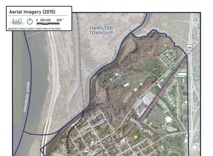
Public Process
The 2021 comprehensive planning process relied on several strategies for public outreach including a steering committee,
on-line survey, and stakeholder focus groups. As prior planning and zoning efforts helped develop an existing level
of community insight, the Planning Team was able to engage in well-informed discussions with the community and
community leaders. Although COVID-19 restricted the ability to host in-person workshops and meetings, use of Zoom
video conferencing at public meetings and with stakeholder groups helped establish a dialogue that underscored past
planning recommendations and guided additional analysis by the Planning Team. While the public outreach process
was sufficient but by no means exhaustive, the comprehensive plan is intended to lay the groundwork for future
discussions.

                                                           Steering Committee
                                                           The Bordentown City Planning Board established a
                                                           Comprehensive Plan Steering Committee to guide
                                                           development of the updated comprehensive plan. The
                                                           committee consisted of nine (9) members including a mix
                                                           of representatives from the planning board, committees,
                                                           local businesses, and residents. Input from the steering
                                                           committee helped shape the goals and recommendations
                                                           throughout the planning process.

                                                           Stakeholder Focus Groups
                                                           The Planning Team held several meetings with key
                                                           stakeholders throughout development of the plan to gather
                                                           focused input related to specific, often overlapping topics.
                                                           For the purposes of encouraging open dialogue, individual
                                                           commentary has been folded into the overall analysis.
                                                           Together, the combined interviews and on-line community
                                                           survey have been insightful and productive.

                                                           Formally and informally, the Planning Team met with:

                                                                  »   Environmental Commission / Green Team
                                                                  »   Bordentown Historical Society
                                                                  »   Downtown Bordentown Association
                                                                  »   Fire and EMS
                                                                  »   Restaurants
                                                                  »   Churches
                                                                  »   Public Schools
                                                                  »   Public Works
                                                                  »   Local Developers

4                                                                                City of Bordentown | Burlington County, NJ
Stakeholder Input Summary
Historic Preservation Open Space, Recreation, Environmental
» Continue to further capitalize on the » Improved maintenance of open space and
area’s historic identity and the associated parks
opportunities for arts, education, tourism » Preservation of remaining greenway
(untapped potential in railroad, shipbuilding, opportunities
indigenous peoples, civil rights...) » Parks serving multiple functions for
» Expand preservation and rehabilitation of socialization, recreation, education
historic resources » Green infrastructure improvements to manage
» Minimize the visual impact of mid-century stormwater and promote renewable energy
garden apartment buildings in the downtown use
» Revisit the Historic Preservation Commission » Legitimizing informal paths near Bordentown
and 2012 Historic Plan Element (i.e. Certified Station, Prince St, and Lime Kiln Alley
Local Government status, historic district » Increased focus on public health goals
expansion, enforcement, and administrative » Planning for electric vehicles, public and
capacity...) private charging station locations
» Pursue historic home programs and » Development of a plan for Point Breeze that
opportunities for education, pride, tourism, bridges historic and environmental needs
rehabilitation » Maintain high density and minimize sprawl
and its effects
Downtown and Commercial
General & Administrative
» Parking management that fully addresses
enforcement and liability concerns with shared » Enhancing communication between
parking Bordentown Township, Fieldsboro and the City
» Enabling pop-up retail in a flexible/manageable » Assessing and responding to the needs of
way emergency services
» Revisit past interests in bed and breakfasts » Property maintenance and permit approval
establishments with appropriate conditions process needs local attention
» Enabling creativity in business opportunities » Increase involvement of historic and
downtown like pop-up retail, etc environmental committees in site plan review
» Continued prioritization of Farnsworth
outdoor dining, street market, and related Streets and Public Infrastructure
opportunities » Improving sidewalk conditions with lighting,
» Renters are important consideration given street trees, grading, addressing hazards,
nature of homeownership versus rent these historic features
days » Strengthening linkages from existing parking to
» Improve the appearance of the highway downtown destinations, etc
corridor » Improving pedestrian safety, visibility, way-
finding, and access to public restrooms
» Expand opportunities for using the street
(markets, fairs, and general dining)
Comprehensive Plan | Land Use Element 5Online Community Survey
An on-line survey was launched by the Bordentown
Downtown and Commercial
City Planning Board with assistance by the Burlington
County Bridge Commission, and Steering Committee. » More local businesses ranked #4 priority by
The survey launched on January 15th, 2020 and closed residents and visitors
on April 20th, 2020 after receiving 351 responses, » 85% agree that historic character and
or approximately 10% of the City population. The downtown shopping/dining make the City a
following is a summary of survey results, organized great place to live
by topic: » Coffee shop, bakery, live entertainment most
wanted businesses downtown followed by
more restaurants, public spaces, and public
Parking
art
» Improving parking is #1 priority for visitors, » 54% of residents and visitors are OK with a
#2 for residents medical cannabis dispensary downtown or
» 87% visitors dissatisfied with parking on the highway
availability
» 70% residents dissatisfied with parking Highway Corridor
availability
» 60% want to see more coordination with
» Bike parking in lieu of a car space is NOT
Bordentown Township regarding Rte.
preferred downtown
130/206
» 36% of residents visit downtown almost daily
Pedestrianism
» 38% of residents visit businesses along
» Pedestrian safety is #3 priority among 130/206 almost daily
residents and visitors
» 93% agree that walkability makes
Bordentown a great place to live
» 93% travel within the City by walking
» 60% want better bike/ped access near
130/206
» 33% dissatisfied with access to D+R Canal
Trail
» 36% of residents visit downtown almost
daily, 38% visit businesses along 130/206
Bicycle Infrastructure
» 82% want more bike parking downtown
» 68% agree bike routes are lacking
» Bike parking in lieu of a car space is NOT
preferred downtown
» 33% dissatisfied with access to D+R Canal
Trail
6 City of Bordentown | Burlington County, NJComprehensive Plan | Land Use Element 7
commun

The vision of the City of Bordentown has been thoroughly established through
its sense of community and the rich history that has unfolded herein. Preserving

                                                                vi
and enhancing the City’s small-town, historic character we will simultaneously
improve safety, quality of life, while continuing to reveal our great sense of
community and market ourselves accordingly. We will work to ensure our
Downtown is vibrant and resilient, we will continue to be good stewards of the
environment and provide opportunities for all our residents, businesses and
visitors alike.
nity profile
Plan Purpose
The direction of Bordentown City has been thoroughly established through a rich history
of planning efforts and adopted documents. Although the City is relatively built-out, a
city never stops evolving. As we approach the 40th anniversary of the previous plan,
the need for a clear and refined vision, based on the availability of new information,
changing conditions, and standing recommendations of previous plans becomes
increasingly important to the City’s future buildout.
The 2021 comprehensive plan aims to clarify the City’s vision and provide a blueprint
of strategies and recommendations to implement it. The following General Vision
statement is intended to consolidate the original 15 goals of the 1983 Master Plan and
provide a clear and concise vision for all future planning efforts that may be expanded
upon in specific elements.
Comprehensive Plan Goals
» To preserve and enhance the City’s small-town, historic character;
ision
» To improve safety, quality of life, social equity, and sense of community for all residents
and visitors;
» To ensure a vibrant downtown and resilient local economy; and
» To advance sustainability and climate resiliency.Community Overview The City of Bordentown is a 1-square-mile community known for its small-town character and historic charm. Settled more than three centuries ago, the City’s abundant historic resources and traditional development pattern have created an irreplaceable vessel for community within a vastly rural and suburban region. The unique pedestrian-scale of Bordentown and its various assets lend themselves to a tightly-knit urban fabric that is home to many long-time residents and frequently visited by others from within the region. The City is located in northern Burlington County and situated at the northernmost edge of the lower Delaware River corridor within convenient reach of Trenton, Hamilton, and southern Mercer County. Many of the City’s unique assets – such as its waterfront, regional trails, historic character, and transit – further contribute to the City’s relationship with neighboring townships and the New York and Philadelphia metropolitan regions. Recognizing the economic implications of the City’s historical tourism, waterfront access, highway frontage, and downtown activity will be a key factor in strengthening the City’s identity and overall vision for the future. The City of Bordentown has an estimated population of 4,012 as of 20201. By 2045, the Delaware Valley Regional Planning Commission (DVRPC) has forecasted a local population of 4,5592 based on growth rates and demographic data. While the City is rather small and predominantly built-out, infill and redevelopment opportunities are expected to create limited capacity for growth. As a result, continual assessment of City needs will remain as vital as ever to maintain and enhance the quality of life of its residents and visitors. 1. 2013-2017 American Community Survey 5-Year Estimates, US Census Bureau 2. DVRPC, Analytical Data Report 22, County- and Municipal-Level Population Forecasts, 2015–2045. 2016 Comprehensive Plan | Land Use Element 11
DEMOGRAPHICS AND HOUSING CHARACTERISTICS

                                                           20101              20182
     Population                                            3,978               3,840
     Population/ sq mile                                   4,282              4,114.1
     Median Age                                             39.6               37.8
     % High School Graduate or Higher                      94.8 %              94.5%
     % Bachelor’s Degree or Higher                         41.6 %             38.6 %
     Households                                            1,850               1,710
       % Family                                            49.9%               49.5%
       % non Family                                        50.1%               50.5%
     Average Household Size                                 2.15               2.19
     Housing Units                                         2,062               2,017
       % Occupied                                          89.7 %             84.8 %
       % Vacant                                            10.3 %             15.2 %
     Occupied Housing Units                                1,850               1,710
       Own                                                 61.2 %             54.5 %
       Rent                                                38.8 %             48.5 %
     Home Ownership Rate                                   61.2 %             54.5 %
     Vacancy Rate                                          10.3 %             15.2 %
     Median Household Income                              $ 66,557           $ 72,879
     Per Capita Income                                    $ 36,814           $ 40,360
     Poverty Rate                                          3.6%                5.9%
     Unemployment Rate                                     12.3%               5.7%
     Median Value of Owner-Occupied Units                $ 254,300           $ 216,400
     Median Gross Rent                                    $ 1,121             $ 1,237

              1. 2010 Decennial Census, US Census Bureau
              2. 2013-2017 American Community Survey 5-Year Estimates, US Census Bureau

12                                                                         City of Bordentown | Burlington County, NJ
Prospective on the Little City with a lot of Charm
The City’s historical patterns of development allow it to remain a resilient place. Over time, the City has ebbed and
flowed with the tide of the mighty Delaware River. Its compact street network, historic development patterns,
and powerful sense of place, though not without its challenges at times, has played host to many formidable
personalities over the centuries and decades since its founding. Demographics change, but Bordentown City is
quintessentially Americana at her best.
As all this prose relates to the Comprehensive Plan, one can merely say that wholesale change is not necessary.
Rather, a more surgical approach to making upgrades and adaptations is more appropriate. Household sizes
across the country have shrunk, and the rise of e-commerce have placed pressures on our beloved Downtown
rarely seen since the advent of the indoor shopping mall, but Bordentown’s strength lies in her people. Faces
change, but what drives people to the City, is the same that keeps us all here - COMMUNITY.
The City of Bordentown has what many other towns in the region do not: deep American history, a downtown
with connected and walkable street network, with a riverine and associated environmental network that is
readily accessible. Strengthening our connections to our assets, locally and regionally should be the goal of any
Comprehensive Plan.
Comprehensive Plan | Land Use Element 13Planning within the Region
State Development and Redevelopment Plan (2001)
The New Jersey State Planning Commission adopted the State Development
and Redevelopment Plan in 2001 to promote cohesive planning efforts at the
local, county, regional, and statewide levels. While the State Plan is due for an
update, it continues to provide statewide planning objectives for municipalities
regarding strategies for land use, housing, transportation, and other areas of
focus.
The State Plan has designated Bordentown City and portions of Bordentown
Township to be within the Metropolitan Planning Area (PA1). Per the State Plan,
Metropolitan Planning Areas are intended to provide for redevelopment and
revitalization, promote compact urban growth, stabilize older suburbs, and
protect the character of existing stable communities. To achieve this vision, the
State Plan establishes specific policies, objectives, and recommendations that
are reiterated throughout the comprehensive plan.
DVRPC Connections 2045 (2017)
The Delaware Valley Regional Planning Commission (DVRPC) is the federally
designated Metropolitan Planning Organization for the nine-county region of
Greater Philadelphia. DVRPC’s Long-Range Plan, Connections 2045, establishes
a vision and sets forth recommendations to coordinate regional transportation
with land use and other objectives.
Connections 2045 identifies five core principles to achieve its regional vision:
» Sustain the Environment;
» Develop Livable Communities;
» Expand the Economy;
» Advance Equity and Foster Diversity; and
» Create an Integrated, Multi-modal Transportation Network.
Through Connections 2045, DVRPC has identified Bordentown City as a Town
Center targeted for investment in transit, redevelopment, and greenway
connections to surrounding farmland and the regional greenspace network.
The goals and recommendations of the 2021 comprehensive plan are intended
to be consistent with the Connections 2045 regional plan and the guidance
therein.
14 City of Bordentown | Burlington County, NJNorthern Burlington County Growth and Preservation Plan
(2008)
The Burlington County Board of Chosen Freeholders adopted the
Northern Burlington County Growth and Preservation Plan (GAPP) in 2008
to promote regional growth management among the 13 participating
municipalities. The GAPP effectively emphasizes the State Development
and Redevelopment Plan and encourages local growth and development
to occur in designated centers – nodes, hamlets, villages, and towns –
while preserving farmland, open space, and natural features.
The GAPP designated Bordentown City as a Town Center envisioned to
incorporate smart growth principles such as transit-oriented development,
a revitalized mixed-use downtown, and infill redevelopment. The
implications of Town Center status for Bordentown in comparison to
surrounding rural townships are considered through nearly all aspects of
the comprehensive plan such as tourism, transportation, boating, trails,
land use, and housing.
Bordentown Township Land Use Element (2019)
Bordentown Township adopted its Land Use Element in 2019, creating
additional context for development at the City’s edges and shared
relationships related to open space, local facilities, municipal services,
trails and greenways, and general relationship between the City and
surrounding Township.
Comprehensive Plan | Land Use Element 15Existing Zoning Summary
A city’s zoning ordinance regulates the location, use, Planned Low Density (PLD)
and form of development within each zoning district. The PLD zone was established to regulate possible
The current zoning ordinance establishes the following subdivision or development of Block 1701/Lot 14, the
districts, summarized below: 100-acre Point Breeze property formerly owned by Divine
» R-1 Residential Low Density Word Missionaries. In 2020, however, NJDEP Green
» R-2 Residential Medium Density Acres and Bordentown City purchased the property for
» R-3 Residential Medium/High Density public open space and reuse of the existing buildings
» PLD Planned Low Density for municipal purposes. As such, the PLD zone has been
» LC Local Commercial rendered ultimately unnecessary.
» HC Highway Commercial
» CI Commercial / Industrial Local Commercial (LC)
» L/M Inclusionary Zoning (Floating/Overlay) The LC zone intends to provide a central business district
» Historic District (Overlay) containing a variety of shops and retail stores at a scale
that preserves the small downtown character. The LC
Residential Low Density (R-1) zone includes parcels along Park Street, Farnsworth Ave,
The R-1 zone permits single-family detached homes and Crosswicks Street, and Burlington Street. Predominant
is characterized by large lot sizes and more restrictive bulk uses within the LC zone include storefronts, neighborhood-
and use requirements than other zones. The R-1 zone oriented services, apartments, and home-offices.
forms the City’s low-density edge along creeks, streams,
and bluffs. Highway Commercial (HC)
The HC zone includes parcels along Route 130/206 that
Residential Medium Density (R-2) are intended to absorb commercial uses that service the
The R-2 zone is intended for single-family detached larger region and typically require greater land area to
dwellings like the R-1 zone but contains bulk requirements develop than the amount of land available downtown.
that are more appropriate for lots of intermediate size Uses along the highway tend to be more oriented to
relative to the R-1 and R-3 zones. Prevailing uses in the automobile use and provide abundant parking.
R-2 zone are single-family detached houses, garden
apartments, and public property. The R-2 zone separates Commercial / Industrial (CI)
the HC zone geographically from other zoning districts.
The CI zone is intended to encourage and minimize the
impact of commercial and industrial facilities on the large
Residential Medium/High Density (R-3) lots between Park Street and Elizabeth Street. Uses in
The R-3 zone is intended for single-family detached, the CI zone include packaging, warehousing, distribution
single-family attached, and single-family semi-detached and storage. The former Ocean Spray plant on Park Street
dwellings. Bulk requirements in the R-3 zone reflect is planned for mixed-use commercial and multi-family
smaller lot sizes than other districts and complement redevelopment.
the historic residential density surrounding the City’s
downtown core.
Comprehensive Plan | Land Use Element 17Inclusionary Zoning (L/M) Residential Zoning Analysis
The L/M zone was established in 2006 to implement the While Bordentown has gradually amended its zoning
Housing Element by identifying a suitable location for ordinance over the years, the adopted regulations are
inclusionary affordable housing. The L/M zone requires rather minimal by today’s standards and generally lack the
that development meet the bulk and design standards vigor to meet the City’s land use goals. In fact, many of the
of the R-3 zone as well as a 20% set aside of units for zoning standards are ill-suited to the City’s prevailing lot
low- and moderate-income households as defined by the sizes, historic character, and natural features. Amending
Council on Affordable Housing (COAH). The L/M zone the zoning code to better accommodate existing and
specifically includes Block 902/Lot 20, the rear portion of desirable conditions with more responsive standards can
Block 902/Lot 23, and Block 1101/Lot 5, but is not shown help simplify the approval process for applicants and the
on the City’s adopted zoning map from 2018. planning and zoning board.
As much of historic Bordentown developed before the
Historic District (Overlay Zone)
invention of modern zoning, applying lot requirements
The Historic District overlays the local commercial district and bulk standards to residential City blocks that have
(LC Zone) along Farnsworth Avenue and the Thompson vastly different lot widths, areas, and development
Street neighborhood, defined as Block 901/Lots 14-28 characteristics adversely affects predictability and
and Block 902/Lots 1-19 in the Historic Preservation smoothness of the development process.
Ordinance. All development applications for properties
and improvements within the historic district must be An analysis of existing lot characteristics based on GIS
reviewed by the Historic Preservation Commission except parcel data emphasizes the need to revisit the bulk and
for in-kind maintenance, repainting, cleaning, emergency area standards of the zoning ordinance.
repairs, and improvements to interiors.
One possible approach to improve the City’s planning
and zoning procedures is adoption of a form-based
code or hybrid zoning code, which can establish basic
physical principles for new construction based on the
existing neighborhood context such as build-to lines
and comparable housing typologies. A code that is
tailored to the City’s historic development patterns can
encourage construction that is predictable yet flexible,
and physically cohesive with current density, irregular lot
characteristics, parking needs, and historic architectural
features. Working with residents on a specific vision for
development standards in the future through workshops
and charrettes can help ensure that any such form-based
requirements meet the needs of the City by creating a
cohesive streetscape without compromising the design
freedom of applicants.
18 City of Bordentown | Burlington County, NJR-1 Zone (Single-Family Detached)
Of the 149 lots,
» 48% do not meet the minimum area of 12,000 square feet;
» 37% do not meet the minimum lot width of 80 feet; and
» 28% meet neither lot area nor width requirements.
R-2 Zone (Single-Family Detached)
Of the 202 lots,
» 41% do not meet the minimum lot area of 7,500 square feet;
» 39% do not meet the minimum lot width of 60 feet; and
» 28% meet neither lot area nor lot width requirements.
R-3 Zone (Single-Family Attached, Detached, and Semi-De-
tached)
Of the 946 lots,
Single-Family Attached
» 50% do not meet the minimum lot area of 3,000 square feet;
» 23% do not meet the minimum lot width of 20 feet; and
» 22% meet neither the lot area nor lot width requirements.
Single-Family Detached
» 79% do not meet the minimum lot area of 5,000 square feet;
» 80% do not meet the minimum lot width of 50 feet; and
» 73% meet neither the lot area nor lot width requirements.
Single-Family Semi-Detached
» 86% do not meet the minimum lot area of 7,500 square feet;
» 80% do not meet the minimum lot width of 50 feet; and
» 77% meet neither the lot area nor lot width requirements.
Comprehensive Plan | Land Use Element 19Existing Land Use Summary
Land use in Bordentown developed through a traditional development pattern typical of a pre-automobile city. Local
commercial uses like retail shops, restaurants, and neighborhood services are generally concentrated within the
historic mixed-use downtown of Farnsworth Avenue. Attached and detached single-family homes, apartments, and
the occasional park or religious institution form quaint but dense residential streets decreasing in density toward the
City’s edges.
The Bordentown waterfront has a long history where shipping, shipbuilding, and railroading converged at the mouths
of the Crosswicks Creek and the Delaware & Raritan Canal system. Larger parcels throughout the City developed over
time and evolved into more specialized uses like senior housing, office buildings, and light industry. Meanwhile, the
highway corridor expanded considerably to accommodate auto-oriented commercial uses fronting Rt-130 and Rt-206
and grew out of the advent of the automobile and New Jersey’s need to off-set property taxes through commercial
ratables.
The Existing Land Use Map largely reveals the result of these development patterns and the land use relationships that
have unfolded over Bordentown’s history. In large part, these patterns have effectively shaped the Proposed Land Use
Map.
The following table is a breakdown summary of the City’s land use composition by acreage and number of parcels,
based on tax data and more detailed field assessment.
Existing Land Use Composition
Land Use Acres % Parcels %
Single-Family Residential 155.6 28.1 1,152 78.5
Multi-Family Residential 43.1 7.8 42 2.9
Mixed Use 5.2 0.9 60 4.1
Office 3.6 0.6 8 0.5
Local Commercial 11.8 2.1 28 1.9
Highway Commercial 20.1 3.6 29 2.0
Industrial 36.1 6.5 6 0.4
Public/Quasi-Public 43.5 7.8 58 4.0
Parking 5.6 1 8 0.5
Park/Open Space 187.1 33.8 34 2.3
Railroad 16.8 3 5 0.3
Utility 16.9 3 4 0.3
Vacant 9.1 1.6 33 2.2
Total 554.3 100 1,467 100
Comprehensive Plan | Land Use Element 21Single-Family homes represent the largest share of the 130 and 206 that are generally oriented to serve passing
City by number of parcels and second largest by acreage. highway traffic. These uses are primarily accessible by car
Of the 1,152 single-family homes within the City, and contain sufficient parking for regional access.
approximately 751 are detached and 478 are attached or
Industrial uses are generally limited to the CI Zone,
semi-attached. The majority of single-family houses are
which comprises large lots that straddle the freight rail
located within the R-3 zone (Residential High Density).
line between Park Street and Elizabeth Street. Additional
Multi-Family residences in Bordentown consist of industrial uses nearer the downtown and residential
low-rises, garden apartments, and two- to four-unit zones, such as auto body shops are preexisting
apartments scattered throughout the City. Some nonconforming uses that are effectively “grandfathered”
commercial buildings in the downtown contain in the zoning code.
accessory apartments on upper floors. Approximately
Parks & Open Space uses include park and recreation
300 apartment units have been approved through
areas owned by the State, County, City, and nonprofit
redevelopment of the Ocean Spray Redevelopment Area.
organizations like the D&R Greenway Land Trust and
Office buildings are generally clustered on Farnsworth Board of Education. Preservation of Point Breeze
Avenue and Third Street. Downtown offices are primarily (formerly Divine Word) by the State of New Jersey for
single-tenant businesses within rehabilitated historic open space has increased the total area of open space in
buildings that may contain accessory apartments on the City by more than 60 acres.
upper floors. The office buildings on Third Street are
The City has approximately 187 acres of parks and open
more suburban in character, each containing multiple
space within its limits. The Open Space and Recreation
tenants that share off-street parking across the street.
map shows a breakdown of the open space system by
In addition, home-offices are permitted within the
property ownership.
downtown and residential zones provided that meet
certain requirements in the zoning code. Public & Quasi-Public uses include public facilities, non-
profit organizations, religious institutions, and other
Local commercial uses such as restaurants, retail shops,
semi-public entities. These uses are located throughout
barber shops, and neighborhood-oriented businesses
the City on public and private land and often represent
are generally oriented to serve the City. While most of
unique partnership opportunities.
these uses are concentrated on Farnsworth Avenue,
some businesses, such as funeral homes and other uses, Vacant land includes undeveloped, underutilized and
are located within residential zones. unpreserved lots. Approximately 43 acres of vacant land
exists in the City, mostly located along the City’s edges
Highway commercial uses include auto-services,
and within environmental sensitive area.
shopping centers, hotels, and drive-thrus along Route
22 City of Bordentown | Burlington County, NJTransit & Trails
Highway and transit connections connect Bordentown to greater Trenton, Philadelphia, and New York. Direct
transportation connections to New York City, Philadelphia, Camden, and Trenton include I-295 to the west and the New
Jersey Turnpike, U.S. 130, and U.S. 206 to the east. Access to public transit includes New Jersey Transit bus and New
Jersey Transit RiverLINE light rail service, which links Bordentown with Camden and Trenton. Further, the Delaware and
Raritan Canal begins in Bordentown and extends north to Trenton where it splits off north toward Lambertville and
northeast toward South Amboy. The canal trail also forms a section of the East Coast Greenway and Delaware River
Heritage Trail extending southward through the City.
NJ Transit RiverLINE
Connecting the Camden-Philadelphia waterfronts to Trenton Transit Center and the Northeast Corridor, the RiverLine
is a tremendous asset to the City and the Lower Delaware Riverfront communities.
NJ Transit Bus 409 (Trenton-Willingboro-Phila.)
The 409 bus line connects people to jobs located along the Rt 130 corridor while servicing the downtowns of the
communities along the way to Camden and connections to Philadelphia. In Bordentown, the bus runs up W Burlington
St and through downtown Farnsworth before continuing north down Park St to Route 206.
Regional Trails
Several regional trails connect the City to the region’s natural and historic resources, utilizing the D&R Canal Trail,
Farnsworth Avenue, Prince Street, and West Burlington Street.
Delaware and Raritan Canal State Park Trail
Delaware River Heritage Trail
Comprehensive Plan | Land Use Element 25Redevelopment and Rehabilitation Areas Bordentown Township has utilized the LRHL to encourage
redevelopment of multiple sites throughout the
Redevelopment and rehabilitation through the Local
Township. In 2019, the Township designated nearly the
Redevelopment and Housing Law (LRHL) are procedural
entire municipality as an Area in Need of Rehabilitation.
planning tools that can help municipalities encourage
The Township has also established several Areas in
revitalization of properties experiencing vacancy,
Need of Redevelopment that may present impacts and
deterioration, or other adverse conditions created
opportunities for the City of Bordentown:
by marketplace variations. Adopted redevelopment
plans and neighborhood revitalization plans can set Southern Gateway Redevelopment Area comprises
specific goals and standards to achieve the City’s vision the commercial district surrounding the southern merge
for revitalization. Rehabilitation areas also enable of Route 130 and 206, which borders the City’s southern
municipalities to offer short-term tax abatements for edge. The Burlington County Bridge Commission prepared
home restoration. a Redevelopment Plan for the area in 2013 that permits a
wide range of commercial uses as a means for economic
The Ocean Spray Redevelopment Area was adopted by development along the highway corridor. While the
resolution in 2012 in response to the blighting influence redevelopment area is under the Township’s jurisdiction,
of the then soon-to-vacated Ocean Spray industrial site at efforts to strengthen the City’s bicycle and pedestrian
104 Park Street. In 2016, the Ocean Spray Redevelopment connections through this area should be explored.
Area Redevelopment Plan was adopted by the City
Commissioners to encourage compatible re-use of the The K Johnson/Agway Yates Redevelopment Plan
Ocean Spray site and adjacent Park Street properties in was adopted in 2007 and amended in 2009. The plan
accordance with the City’s plan goals and smart growth is intended to encourage mixed-use development and
principles. As of the adoption of the 2021 comprehensive local employment along the Route 130 to the north of
plan, the site remains vacant although a site plan for the City. Although ongoing development of the site is
mixed-use commercial and residential development has characteristic of highway business-park development,
been approved. Recommendations for amendment of the City and Township may work together in the future
the Ocean Spray Redevelopment Area Redevelopment to further integrate the project into the social and
Plan are included in subsequent sections of this plan. urban fabric of the area through bicycle and pedestrian
connections to employment, commerce, housing, and
The Former Bob McGuire Chevrolet Site was adopted in open space.
2015 for commercial revitalization of the highway. After
a redevelopment plan was adopted in 2016, complete The SAAJ-Taylor/Red Roof Inn Redevelopment Area
redevelopment of the site has resulted in a hotel and was adopted in 2008 comprising 7 acres along Route
auto wash facility. 130/206 south of Ward Avenue. As of 2021, a Holiday
Inn Express has been built, while the pad site fronting
The Route 206 & Elizabeth Redevelopment Area was Bordentown City remains vacant.
adopted in 2019 to promote revitalization of the 5-acre
site along Route 206 S and north of Elizabeth St. The site
comprises four parcels (Block 1501, Lots 37.01 – 37.04 ) of
which two are occupied by an existing gym, self-defense
school, and auto repair shop. The middle two parcels
remain vacant and undeveloped. A Redevelopment Plan
for the area has yet to be submitted and adopted.
Comprehensive Plan | Land Use Element 27Climate Change Vulnerability
Communities throughout New Jersey are expected to experience a wide range of effects from climate change. To urge
local resiliency planning, Governor Phil Murphy signed legislation in February 2021 mandating that land use plan ele-
ments include an assessment of climate change vulnerability and specific strategies for improving local resiliency. The
following assessment of climate change in Bordentown is based on findings by the Burlington County Hazard Miti-
gation Plan, NJDEP Scientific Report on Climate Change, and additional resources made available by state, regional,
and national agencies.
Sea-Level Rise
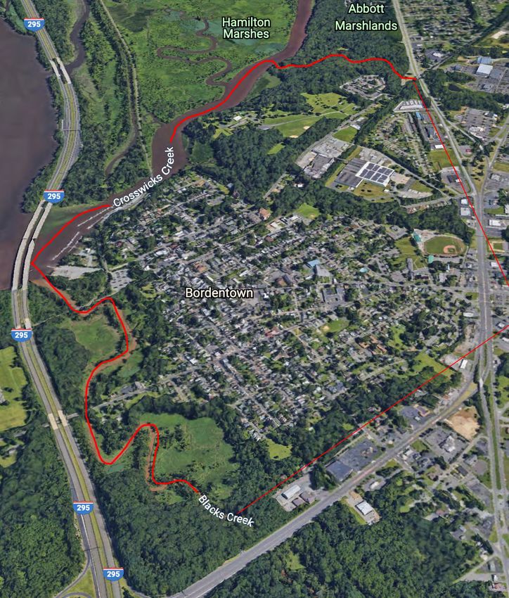
As the City of Bordentown is located along the tidally Water levels along the Delaware River, Crosswicks Creek,
impacted waterways of the Delaware River and and Blacks Creek are anticipated to encroach existing
Crosswicks Creek, rising sea-levels and increased severity wetlands and areas currently located within the 100-Year
and frequency of precipitation will require additional (1-percent annual chance) flood zone. As a result, gradual
efforts to minimize flood hazards. Particular attention inundation and greater high-tide water levels are likely to
to critical facilities such as utilities and transportation contribute to losses in land area at Bordentown Beach,
infrastructure will be necessary for protecting health and Lime Kiln Alley Park, and throughout the Blacks Creek
safety in addition to maintaining the longevity of public stream corridor. Because most of these vulnerable areas
infrastructure. already experience intermittent tidal flooding or are
located within or near wetlands and floodway, significant
NJDEP has identified three primary scenarios for sea-
losses of buildable land by 2050 will be minimal.
level rise by 20501:
However, based on the projected sea-level rise, trees,
» 83% chance of exceeding 0.9ft;
shrubs, and other vegetation will likely experience
» 50% chance of exceeding 1.4ft; and
increased stress and dieback as sea-levels continue to
» 17% chance of exceeding 2.1ft.
encroach the City’s low-lying areas. Further assessment
To assess sea-level rise vulnerability in Bordentown based of erosion control and potential losses to tree canopy,
on the projected scenarios, a Sea-Level Rise Vulnerability habitat, and marshland evolution resulting from sea-
map has been prepared using GIS data published by level rise are recommended for future updates to the
the National Oceanic and Atmospheric Administration City’s Environmental Resource Inventory to assist with
(NOAA). responsive long-term planning.
1. Scientific Report on Climate Change, NJDEP, 2020
28 City of Bordentown | Burlington County, NJPrecipitation
Spatial climate data have been prepared and mapped on-line by the New Jersey Climate Change Resource Center
at Rutgers University. Based on locally adapted projection models, Bordentown may experience some increase in
precipitation by 2040 as noted below.
Changes in Precipitation
1981 – 2020 Average 2020 – 2040 Projected Average
Mean Monthly Precipitation (Summer) 4 – 5in. 5 – 6in.
Mean Monthly Precipitation (Winter) 3 – 4in. 3 – 4in.
An increase in precipitation may cause existing flood zones and wetlands to encroach on areas that do not typically
experience flooding. Specifically, expansion of the existing floodplain into areas further from streams and shorelines
may be expected further upstream. As future flood zones are not available as of the date of this assessment, the City
should remain up to date with the latest Flood Insurance Rate Maps (FIRM) and FEMA flood-hazard data as the effects
of sea-level rise develop and additional guidance and data from national and state agencies are published.
Temperature
Spatial climate data have been prepared and mapped on-line by the New Jersey Climate Change Center at Rutgers
University. Based on locally adapted projection models, Bordentown may experience several changes in temperature
trends by 2040 as noted below.
Changes in Temperature
1981 – 2020 Average 2020 – 2040 Projected Average
Days with High Above 95°FCritical Facilities Future Build-Out
Bordentown Sewerage Authority Wastewater Pump The City of Bordentown is relatively built-out, growth
Station and development is primarily limited to redevelopment
A wastewater pump station operated by the Bordentown and scattered-site infill on scarcely remaining lots. As a
Sewerage Authority is located within the existing 100- result, large-scale impacts on impervious coverage and
year and 500-year flood zones in addition to steep slopes flood capacity are not expected. While preservation of
greater than 15%. As such, the station is susceptible to the Point Breeze site has reduced the City’s buildable
increased flooding, erosion, and landslides. land by more than 60 acres, 42 acres, is considered
vacant undeveloped, or potential buildable land.
W Burlington Street Bridge
Other parcels in the MOD IV that may in-fact be
The W Burlington Street bridge over Blacks Creek is identified as underutilized, include the 14.3 acre Ocean
located along County Route 662. The bridge footprint and Spray Redevelopment Area, which is one of the few
its approximate 450-foot approach is located within the parcels identified in the chart below as able to handle
100-year and 500-year flood zones. Assessment by the any significant development. The Plan calls for mixed-
Burlington County Bridge Commission may be necessary use residential development not to exceed 20 units/
to evaluate the impacts of sea-level rise, erosion, and acre with a minimum of 50,000-SF of adaptive reuse
general effects of increased flood risk. The W Burlington commercial. Of the other parcels identified, only Rt 130
Street bridge is used by NJ Transit Bus 409. properties have real development potential.
NJ Transit River LINE Considering existing floodplains, existing wetlands,
and the projected one to two feet of sea-level rise,
Portions of the light rail tracks and track embankments
approximately 17-18 acres of vacant or buildable land
are located within the 100-year and 500-year flood zones
of the 42 acres identified could contribute to the City’s
and steep slopes, putting the rail infrastructure at risk for
future buildout.
flooding, soil erosion, and landslides.
Build-out Analysis
Location Address Block/Lot Acreage Buildable
1601 / 21
1) Ocean Spray Redevelopment Area 104 Park St 14.3 Y
1702 / 1.01, 2, 3
2) Route 206 & Elizabeth Redevelopment 1501 / 37.02,
909-911 US 206 S 1.63 y
Area 37.03
3) 28 E Chestnut St 28 E Chestnut St 403 / 11 0.62 y
4) Park & Farnsworth (Corner) 1 East park 904 / 23 0.11-0.27 y
5) 3rd Street Parking Lot 24-30 Third Street 902/20 1.79 n
6) 244 Rt 130 (Cheyanne rear land locked) 244 Route 130 403/5 0.84 n
7) Black’s Creek Parcel 20 Mill Street 204/47 15.6 n
8) Pine Street Bluffs Pine Street 202/4 2.1 n
9) 3rd and Ann Street 1 Ann Street 1102/1 0.32 n
Comprehensive Plan | Land Use Element 33Advancing Resiliency throughout the Comprehensive Plan
Adopted elements of the comprehensive plan, such as Circulation, Parking, and Economic Development
the Conservation Plan Element, Open Space Element, Preparation of the Circulation and Parking Element is
and Utilities Element adopted in previous years include recommended to include a more detailed assessment
varying levels of discussion related to flood-hazard. Future of green stormwater infrastructure opportunities
updates to the comprehensive plan through additional to incorporate best management practices into the
elements are recommended to include additional streetscape. These efforts are also recommended to
assessment of climate change resiliency strategies. advance economic development goals for revitalizing the
downtown.
Open Space, Recreation, and Conservation
Through efforts by the City, D&R Greenway, the Green Additional Vulnerability Planning Efforts
Team and others, Bordentown has gradually preserved The City adopted a Flood Damage Prevention Ordinance
increasingly flood-prone areas along streams and in 2017… In addition, the City has or is amidst amending
waterways. The Open Space Element and Conservation its Stormwater Management Ordinance to comply with
Plan Element recommend continued preservation of updated NJDEP municipal stormwater regulations.
greenways and development of trails along stream Bordentown Water Department Asset Management Plan
corridors and remaining natural land. These efforts are and Burlington County Hazard Mitigation Plan,
compatible with and complementary to flood hazard
mitigation efforts, which places additional emphasis on
the importance of conserving land for ecological services
like flood capacity and erosion control.
34 City of Bordentown | Burlington County, NJImplementation Strategies
Green Stormwater Infrastructure
As noted in other sections of the comprehensive
plan, use of green stormwater infrastructure (GSI) is
recommended to mitigate flooding throughout the City.
Widespread use of features like swales, rain gardens,
rain barrels, permeable pavement, and drought- and
flood-tolerant landscaping can help manage stormwater
on-site by reducing the amount of runoff entering the
City’s storm sewers and waterways. Implementation
of GSI is recommended through capital improvement
planning, design of parks and public spaces, streetscape
improvements, and revised landscaping standards of the
zoning ordinance.
Combating the Urban Heat Island Effect
To reduce solar heat gain, also known as the urban heat
island effect, the City may consider increased shade
tree plantings, preservation of mature tree canopy,
and use of lighter groundcover to help offset projected
increases in temperature while improving overall quality Rain gardens on public streets can manage stormwater,
of life throughout the City. It is recommended that the beautify the City, and calm traffic.
Shade Tree Committee, Green Team, and Environmental
Commission continue to maintain an inventory of the
City’s shade tree infrastructure and identify needs for Advancing Land Conservation
expansion. Additionally, use of materials that increase Conservation of environmentally sensitive land can help
the reflectivity of ground and building coverage should preserve the City’s natural flood capacity and mature
be encouraged. Implementation may be achieved tree canopy to help offset the effects of climate change.
through sufficient review of development applications, Conservation restricted zones as proposed by the Land
reinforced zoning and landscaping standards, and capital Use Element are recommended to preserve forested land
improvement planning for parks, streetscapes, and other along stream corridors which provide ecological services
public property. to the City such as flood capacity, erosion control, micro-
climate, and other benefits.
Promoting On-Site Renewable Energy
An increase in average temperatures may lead to higher Snow and Ice Management
peak energy demand for air conditioning. To improve A warmer and wetter climate may worsen winter
local resiliency and potentially reduce the likelihood conditions in Bordentown. The City already does a great
of brownouts, the City should continue to encourage managing snow and ice removal. Notwithstanding, a
public and private investment in solar and other locally plan for the City’s public walkways could help minimize
renewable energy sources. hazards for pedestrians.
Comprehensive Plan | Land Use Element 35land u
Land Use Goals
The Goals of this Plan are steeped in public input and bridge the City’s rich history with an
eye on the future. While these 10 basic goals are broken down further by specific land use
category to follow, they work to achieve a holistic vision for the entire City.
1) Nurture a vibrant and resilient downtown.
2) Provide high-quality and diverse housing opportunities.
3) Preserve and reinforce historic heritage.
4) Embrace the highway corridor.
5) Re-orient the waterfront.
6) Promote climate resiliency and environmental stewardship.
7) Advance public health and safety.
8) Strengthen regional planning efforts.
9) Provide adequate and integrated open spaces.
10)Improve mobility and access.use element goals
Economic Development Goals
        1 Preserve and enhance the historic, mixed-use character of the downtown and further integrate
        1.
           history into the City’s economic development strategy while remaining able to adapt to changing
           times to economic resiliency.
        2 Improve safety and comfort for pedestrians, bicyclists, and transit ridership through streetscape
        2.
           improvements and capital investment planning.
        3 Strengthen pedestrian activity through a strategic balance of uses and integration with public
        3.
           spaces and streets.
        4.
        4 Enhance connectivity and wayfinding to community assets like historic landmarks, transit stops,
           open space, and public parking.
       55. Promote opportunities for contextually-appropriate infill, redevelopment, and adaptive reuse of
           historic structures.
       66. Manage parking and circulation to improve safety, visibility, mobility, and access for all modes of
           transportation.
        7. Treat public streets as public spaces by continuing to explore opportunities for streetscape
        7
           amenities, open streets, parklets, and pocket parks.
        8. Embrace the highway corridor by improving safety, access, and gateways into the City while
       8
           strengthening the City’s ratable base.
        9. Stay current with emerging land uses, legislation, economic strategies, and administrative best
        9
           management practices.

38                                                                            City of Bordentown | Burlington County, NJ
You can also read