Connecting Oxfordshire: Local Transport Plan 2015 - 2031 Banbury, Bicester, Carterton, Science Vale & Science Vale Cycle Strategy and Witney Area ...
←
→
Page content transcription
If your browser does not render page correctly, please read the page content below
Connecting Oxfordshire: Volume 8 Part ii                           Updated 2016
     _____________________________________________________________________

Connecting Oxfordshire:
Local Transport Plan 2015 – 2031

Banbury, Bicester, Carterton, Science Vale &
Science Vale Cycle Strategy and Witney Area
Strategies

      _____________________________________________________________________
                                  Page 1 of 85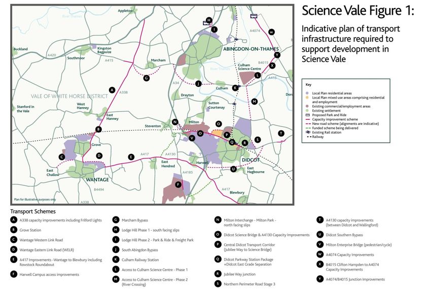
Connecting Oxfordshire: Volume 8 Part ii Updated 2016
_____________________________________________________________________
Pages
1 Banbury Area Strategy 3
2 Bicester Area Strategy 14
3 Carterton Area Strategy 28
4 Science Vale Area Strategy 35
Science Vale Cycle Strategy 53
5 Witney Area Strategy 76
_____________________________________________________________________
Page 2 of 85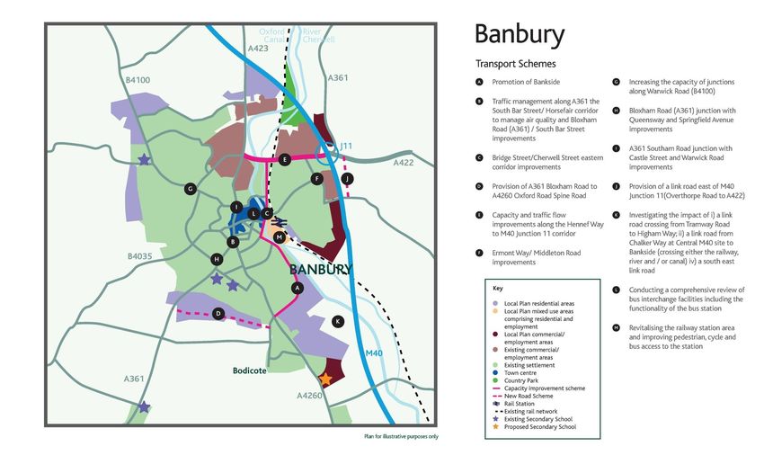
Connecting Oxfordshire: Volume 8 Part ii                           Updated 2016
     _____________________________________________________________________

Banbury Area Strategy

The Local Context
1. Banbury is Cherwell’s largest town and Oxfordshire’s second largest
   settlement, with a population of nearly 47,0001. Banbury acts as a Primary
   Regional Centre that serves a wide sub-region, with a diverse economy
   focused on manufacturing, logistics, distribution and services and increasingly,
   high tech manufacturing. In addition to provision of significant employment
   opportunities, the town also provides a focus for major retail, housing, cultural,
   leisure and community activities.
2. Located in north Oxfordshire, Banbury’s central position in the wider region
   and its excellent transport links means that the town has a far-reaching
   catchment and area of influence extending north to Birmingham, Coventry
   and Northampton; east to Milton Keynes, Brackley and Buckingham; west to
   Stratford on Avon and Chipping Norton; and south to Oxford, Bicester and
   Aylesbury.
3. The aim in Banbury is to strengthen the town centre and its economy by
   boosting its vitality and attractiveness through strategic investment and
   regeneration thereby providing a full range of facilities, whilst safeguarding the
   town’s historical character.
4. The Cherwell Local Plan anticipates that the town will continue to grow
   significantly by 2031, with new employment and residential areas proposed,
   and creation of a more diverse economy. By 2031, the adopted Local Plan2
   proposed that there will be an additional 7,319 houses 3 and 3,500 jobs in
   Banbury, at key employment sites including Central M40, to the east of
   Banbury (2,500 jobs); and on land North East of M40 Junction 11 (1,000
   jobs)4. These sites are shown in Figure 15.1. In his report on the Local Plan
   (June 2015) the Inspector recommends that the scale of employment on land
   North East of M40 Junction 11 be reduced from 49ha to 13ha, in turn reducing
   the number of jobs to 1,000.
5. The emerging Banbury Masterplan supports the Local Plan proposals and will
   provide the overall framework and vision for guiding the sustainable growth of
   the town to 2031. It aims to rejuvenate the town centre with a focus on
   developing shopping, leisure and night time economy activities, and to secure
   the long term role of the town centre.
6. This Transport Strategy for Banbury supports delivery of the Cherwell Local
   Plan; the Banbury Masterplan and its overall vision for Banbury; and the
   Canalside Supplementary Planning Document.

1
  Census Data 2011, NOMIS
2
  Cherwell Local Plan 2011-2031 Part 1 (Adopted 20 July 2015)
3
  Inclusive of committed development and Cherwell Local Plan 2011-2031 Part 1 (Adopted 20 July 2015
4
  Policy Banbury 15: Employment Land North East of Junction 11, Cherwell Local Plan 2011-2031 Part 1
(Adopted 20 July 2015)

        _____________________________________________________________________
                                    Page 3 of 85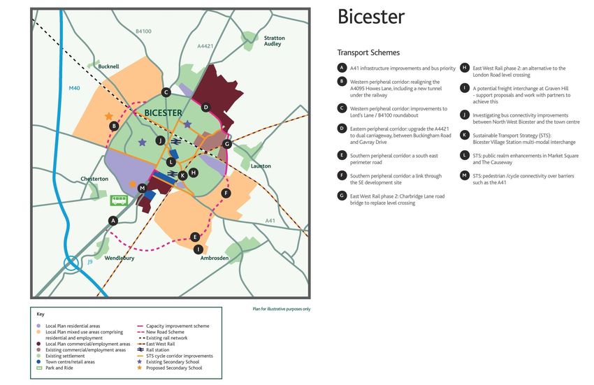
Connecting Oxfordshire: Volume 8 Part ii Updated 2016
_____________________________________________________________________
Transport in Banbury
7. Banbury has excellent road connections, with access to the M40 via Junction
11 and with several strategic A roads serving the town. Movement to, from
and within Banbury has historically been influenced by a range of physical
and environmental constraints including the rail line through the centre of the
town and the Oxford Canal and River Cherwell, both of which dissect the town
from north to south. The historic areas of Banbury also influence traffic
movements, particularly around the town centre where there are a number of
one-way, narrow and pedestrianised areas.
8. Banbury has a range of bus routes linking residential areas with the town
centre; these have developed incrementally overtime and form an inefficient
pattern. Many of these routes have required subsidy to operate as they are
not serving the commercial commuter market. The quantum of development
in Banbury, to be delivered through the Local Plan, offers an excellent
opportunity to rationalise the bus network to link homes to employment across
the town.
9. Banbury rail station is strategically located on the national rail network,
between London and Birmingham. New investment in rail infrastructure has
substantially reduced the travel time from Banbury to both cities, with regular
high quality train services serving Banbury and excellent links to other centres
including Bicester and Oxford. Nationally, there are emerging rail proposals
for strategic electrification upgrades which are to be undertaken on the Oxford
to Banbury line. These are likely to have a significant impact on the town’s
rail station and adjacent infrastructure and present an opportunity for
complementary transport network improvements.
Transport Strategy Aims
10. This Transport Strategy identifies a series of improvements to address the
existing transport issues in Banbury, and to manage the increased travel
demand that will be generated by development in the town. The Strategy will:
Deliver infrastructure improvements to increase the overall capacity of
the local transport networks whilst also supporting sustainable travel.
Facilitate and promote sustainable travel for trips to, in and around
Banbury, including use of the bus, walking and cycling, including Door to
Door travel (e.g. walking or cycling combined with bus/rail). Further
details can be found in the Active & Healthy Travel section. A step-
change in the increased use of sustainable transport modes is essential
to support growth in Banbury. The Sustainable Transport element of the
Strategy will play a key role in reducing the volume of traffic associated
with the town’s significant growth and mitigating the traffic impacts on
local roads serving Banbury.
Infrastructure Improvements
11. Infrastructure schemes which seek to improve the operation of the existing
highway network, address current transport issues in the town, and protect
sensitive areas, continue to form a key element of the Transport Strategy for
_____________________________________________________________________
Page 4 of 85
Connecting Oxfordshire: Volume 8 Part ii Updated 2016
_____________________________________________________________________
Banbury5. These improvements comprise:
Promotion of Bankside, comprising: i) Modification of traffic calming along
Bankside; ii) Signalisation of Hightown Road / Bankside junction; and iii)
Signal timing optimisation at Swan Close Road. This is being progressed and
funded as part of the Longford Park development.
Traffic management along A361 the South Bar Street/ Horsefair corridor.
This is an historic corridor which has recently been declared an Air Quality
Management Area (AQMA) primarily due to traffic impact. Measures to
encourage alternative routing to reduce the number of vehicles using this
route and improve traffic flow will be examined.
Developing the Cherwell Street ‘Eastern Corridor’ as the preferred north-
south route through the town. Due to the Air Quality Management Area at
North Bar, and the weight limit restrictions at Queensway, Cherwell Street is the
main north-south route through Banbury. While the focus will be to establish
this corridor as the preferred north-south route through the town, a key
consideration will be the need to balance the conflicting travel needs of
vehicular access north-south, pedestrians crossing east-west, and bus
movements. The Cherwell Street scheme will include improvements to the
Bridge Street / Cherwell Street junction and a review of highway space from
Swan Close Road to Bridge Street to improve traffic flow, and bus movements,
but also reduce severance and increase the ability for pedestrians to cross the
road. This scheme will be developed in conjunction with town centre
redevelopment, in particular through the Canalside Supplementary Planning
Document. Additionally, this scheme is co-dependent on the Bankside
scheme, particularly the changes at Swan Close Road.
Provision of additional capacity at the Bloxham Road (A361) / South Bar
Street junction will also be implemented by the Longford Park development.
12. Additional infrastructure improvements will be delivered to support future
regeneration of Banbury and the Local Plan development proposals:
A361 Bloxham Road to A4260 Oxford Road Spine Road through the
residential development South of Salt Way: The coordinated approach to
development to the south of Banbury as outlined in the Cherwell Local Plan
2011 – 2031 (July 2015), will enable provision of essential infrastructure
including delivery of an east-west link from the A361 Bloxham Road to join
White Post Road and the A4260 Oxford Road. This road will support
operation of commercially viable bus services through the development,
increasing accessibility and long term sustainability of the development. The
spine road will be built by the developer.
Capacity and traffic flow improvements along the Hennef Way to M40
Junction 11 corridor (an AQMA), will be investigated in 2016/17 including:
- Hennef Way/ Southam Road and Hennef Way/ Concord Avenue
improvements.
5
As identified in the Banbury Movement Study, 2013
_____________________________________________________________________
Page 5 of 85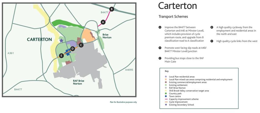
Connecting Oxfordshire: Volume 8 Part ii Updated 2016
_____________________________________________________________________
- Hennef Way/ Ermont Way improvements: replacement of the existing
roundabout with a signalised junction.
- Ermont Way/ Middleton Road improvements: increased capacity provided
at entry to roundabout.
- Junction improvements/ traffic signal optimisation along Hennef Way and
at M40 Junction 11.
As developments sites come forward, it is likely further capacity
improvements will be required at other sensitive junctions. Where
possible improvements will be directly secured from development sites.
Improvements at, but not limited to, the following will be sought:
- Warwick Road (B4100) roundabout junctions with A422 Ruscote Avenue
and Orchard Way
- Bloxham Road (A361) junction with Queensway and Springfield Avenue
- A361 Southam Road junction with Castle Street and Warwick Road.
13. In the longer term (post 2024), there is likely to be a need for additional road
capacity to manage anticipated traffic growth at M40 Junction 11.
A new link road east of Junction 11 will provide a strategic solution to
helping mitigate the impact of traffic travelling to/from Banbury from
surrounding areas including from the M40.
14. The increase in Local Plan growth to the south of Banbury has renewed the
need to investigate the opportunities, costs and benefits of a link road over the
railway for the post 2024 period, to manage traffic movements within the town.
A study will consider several route options such as Tramway Road to Higham
Way and Bankside to Chalker Way and review other south east link road
routes. These options will be assessed by the County Council and the
evidence from this study will inform further decision making.
15. To improve traffic circulation around Banbury, signage will be reviewed and
enhanced. Car parking in the town centre will also be reviewed and the
distribution of car parks improved. Car parking matrix signs will be introduced
to signpost drivers more effectively to car parks with spare parking capacity.
BAN1 – We will seek opportunities to deliver transport schemes
which will support the regeneration and growth of Banbury to 2031
and protect the historically sensitive areas of the town through:
Promotion of Bankside.
Traffic management along A361 the South Bar Street/ Horsefair
corridor.
Bridge Street/ Cherwell Street eastern corridor improvements.
Bloxham Road (A361)/ South Bar Street improvements.
Provision of A361 Bloxham Road to A4260 Oxford Road Spine
Road.
_____________________________________________________________________
Page 6 of 85Connecting Oxfordshire: Volume 8 Part ii Updated 2016
_____________________________________________________________________
Hennef Way/ Southam Road improvements.
Hennef Way/ Concord Avenue improvements.
Hennef Way/ Ermont Way improvements.
Ermont Way/ Middleton Road improvements.
Increasing the capacity of junctions along Warwick Road
(B4100).
Bloxham Road (A361) junction with Queensway and Springfield
Avenue improvements.
A361 Southam Road junction with Castle Street and Warwick
Road improvements.
Provision of a link road east of M40 Junction 11 (Overthorpe
Road to A422).
Investigating the impact of i) a link road crossing from Tramway
Road to Higham Way; ii) a link road from Chalker Way at Central
M40 site to Bankside (crossing either the railway, river and / or
canal) iv) a south east link road.
Reviewing the highway signage on routes into the town centre to
sign north-south through-traffic away from sensitive areas of the
town centre and promote appropriate route choices at key
decision making junctions.
A car park review and improvements, and provision of car park
matrix signs.
Sustainable Transport Strategy
16. Travel to Work Census data (2011) highlights the significant opportunity that
exists for encouraging sustainable travel in Banbury and delivering an
increase in the use of sustainable modes for travel around the town.
Whilst a significant number of Banbury residents travel to Oxford for work,
60% of journey to work trips are currently undertaken within the town i.e.
with a home origin and a work destination in Banbury. However, despite
the local pattern of work trips, whilst 32% of these trips are undertaken on
foot, 57% of these local trips are undertaken by car. Only 3% are
undertaken by bus and 6% by cycle.
17. A Bus Strategy (see LPT4 Volume 4) for Banbury is therefore being
developed with the aim of improving the bus network. In conjunction with
the local bus operators, a review is being undertaken of bus operations in
the town which will identify short, medium and long term route changes
(including any infrastructure requirements) to provide direct commercial bus
routes from residential areas, via the town centre to the employment areas.
18. The first service improvements will be to improve bus links between
residential development in the west of Banbury and employment sites on
the east side of town. This will involve working closely with a range of
_____________________________________________________________________
Page 7 of 85Connecting Oxfordshire: Volume 8 Part ii Updated 2016
_____________________________________________________________________
stakeholders including Cherwell District Council, bus operators, developers,
local employers and business groups.
19. The aspiration to serve Banbury Rail station with an increased variety of
bus services will be explored by examining opportunities to route buses
from the town centre to the Thorpe Way employment area via Higham
Way, thus serving the new eastern station entrance in the multi-storey car
park. In addition, on the western side of the station, work will be undertaken
with landowners to open Station Approach and Tramway Road to through
bus services.
20. Improving bus journey time reliability will be considered as well other
improvements, including bus-only access links. This will complement bus
service enhancements by enabling faster, more reliable bus journeys to
ensure that the bus becomes a genuinely attractive option.
21. The existing bus station in Banbury is unwelcoming for passengers and
under-used by operators. The Banbury Masterplan will consider if the
current bus station layout and access arrangements can be improved, or
whether a bus station at a different town centre location offers greater
benefit to the town, including considering if a bus station is required at all or
whether a series of on street bus stops could better serve Banbury.
22. We will continue to ensure new development sites are served with high
quality commercially viable public transport services, through a variety of
mechanisms, including seeking pump priming funding.
BAN2 – We will work closely with Cherwell District Council, bus
operators and other strategic partners to deliver the Banbury Bus
Strategy, which seeks to deliver a commercial bus network for Banbury.
Increased bus use will be achieved by:
Promoting a bus route serving Bretch Hill>Banbury Town Centre>Rail
Station (at Higham Way)>Thorpe Way>Wildmere Road>Banbury
Gateway Retail Park. This scheme will explore the option of opening a
bus-only route from Alma Road to Thorpe Way in order to provide bus
journeys direct to the employment site. New bus stops will be introduced
along the route.
Undertaking feasibility work into the costs and benefits of routing buses
through the pedestrianised town centre.
Conducting, in line with the Banbury Masterplan, a comprehensive
review of bus interchange facilities including the functionality of the bus
station.
Conducting, in partnership with bus operators, a comprehensive review
of town wide bus services to identify short, medium and long term route
changes (including any infrastructure requirements) to provide direct
commercial bus routes from residential areas, via the town centre to the
employment areas.
Identifying suitable routes into and through the town centre.
_____________________________________________________________________
Page 8 of 85Connecting Oxfordshire: Volume 8 Part ii Updated 2016
_____________________________________________________________________
Opening up Tramway Road as an access for cars into and out of the
station car park and access to the Canalside development.
Exploring opening Station Approach to through bus services via
Tramway Road.
Developing inter-urban services through enhancement of existing bus
services or new services.
Seeking funding from new development sites to ensure they are served
by high quality commercial public transport services.
23. The Government's plans to electrify the rail line through Banbury will
provide a catalyst for economic growth and will result in increased
passengers at Banbury Rail Station. We will take advantage of the
opportunities created by electrification, to revitalise the Rail Station and
improve access to it.
24. Improvements to the Bridge Street junction, together with supporting public
realm enhancements throughout Canalside, will provide greater connectivity
to the railway station and the town centre, to accommodate trips
associated with development in the area and promote sustainable access.
BAN3 - We will strengthen Banbury’s position on the rail network
through revitalising the railway station area and improving pedestrian,
cycle and bus access to the station.
We will work with our strategic partners to develop Banbury Station as a
transport interchange. This is likely to involve re-designing the station
forecourt to create an interchange that will feature a taxi rank; better cycle
access and facilities (including secure cycle storage); an improved route
to the station for people on foot, and improved public realm giving a
sense of arrival.
We will improve walking, cycling and public transport links to the station
in order to meet future demand and to better connect the station to the
town.
Increase the variety of bus services passing the rail station, including
exploring opportunities to route buses via Higham Way, and from
Tramway Road to Station Approach.
We will seek to maximise the opportunities national rail electrification
proposals could bring to improving the transport networks, particularly at
Bridge Street and around the rail station.
25. Walking and cycling will be promoted and encouraged for short trips in
Banbury, through improvements to pedestrian and cycle infrastructure. As
well as reducing car trips on the network, this will also promote healthy and
active transport, as well as complement Oxfordshire County Council’s Air
Quality strategy. More information on our strategy for active travel in
Oxfordshire can be found in Oxfordshire County Council’s Active & Healthy
Travel Strategy.
_____________________________________________________________________
Page 9 of 85Connecting Oxfordshire: Volume 8 Part ii Updated 2016
_____________________________________________________________________
26. The current cycle network is fragmented and does not encourage cycling.
In the medium/ longer term, a network of cycle routes will therefore be
developed to serve those areas which are identified as having the greatest
potential for an increase in cycling. In line with the Active & Healthy Travel
Strategy, we will continue to work with developers of new residential and
employment sites to provide facilities for pedestrians and cyclists to access
key off-site amenities such as trips to work, school, and, as previously
mentioned, access to the rail station.
BAN4 - We will work closely with Cherwell District Council and other
strategic partners, and developers to provide facilities for pedestrians
and cyclists and we will work to fill in the gaps in the walking and
cycling network, including Public Rights of Way.
Seek funding from new development sites to ensure they are served by
high quality walking and cycling routes to off-site amenities.
Conduct walking and cycling network assessment studies and prioritise
improvements to deficiencies in the networks.
As identified in the Cherwell Local Plan 2011 – 2031 (part one) seek
new pedestrian and cycle bridges, as part of the Canalside
development, crossing the Oxford Canal and River Cherwell which will
connect the rail station to the town centre.
27. Residential Travel Plans and Workplace Travel Plans will be secured for all
new developments that meet OCC’s thresholds. Residential developers will
be expected to support and promote sustainable travel options to new
occupiers e.g. through personalised travel planning, whilst occupiers of
employment sites will be required to implement a Workplace Travel Plan.
28. With the significant amount of employment proposed in Banbury, Delivery &
Servicing Plans (DSPs) will also be an important tool for managing trips on
the road network and protecting historic and sensitive areas. For example,
DSPs will provide a mechanism for encouraging deliveries to take place
outside of peak hours, and for larger vehicles to use designated routes.
29. We will work with HS2 Ltd to understand and identify means to mitigate the
impact of the construction works associated with HS2 across North
Cherwell, particularly at Banbury.
30. Construction Logistics Plans will also be required for development sites.
BAN5 - Travel Plans, Delivery & Servicing Plans and Construction
Logistics Plans will be secured for all new developments that meet
OCC’s thresholds. Travel Plan/ DSP monitoring contributions will be
secured.
This policy supports delivery of the Sustainable Transport Strategy.
We will seek mitigation from the impact of High Speed 2 (HS2)
construction traffic across North Cherwell and Banbury.
_____________________________________________________________________
Page 10 of 85Connecting Oxfordshire: Volume 8 Part ii Updated 2016
_____________________________________________________________________
Scheme Delivery
31. Where transport schemes are needed to mitigate the impact of a particular
development, provision of infrastructure and/or financial contributions will
be secured from the developer.
32. This Area Strategy also identifies a package of transport measures that are
required to mitigate the cumulative impact of development in
Banbury. Developer contributions will therefore be sought towards
schemes within the Area Strategy using a strategic transport infrastructure
contribution rate to mitigate the cumulative impact of development.
Additional funding for these strategic schemes may also be sought via the
Local Enterprise Partnership and the Local Transport Board to the Local
Growth Fund and other sources.
33. Major residential development sites are required to fund new or improved
public transport services to key locations agreed with the County Council
until they become commercially viable. Other residential sites will be
required to make a public transport contribution towards improving bus
services, including improved pedestrian/cycle routes to bus stops and cycle
parking if appropriate, based on the size of the development.
34. Developments are also required to provide modern bus stop infrastructure,
including shelters and Real Time Information, to enhance access to the
public transport network. These are usually secured through Section 106 or
Section 278 agreements.
35. When the Community Infrastructure Levy (CIL) is introduced by Cherwell
District Council contributions will be sought via this new mechanism, as
well as via S106 or S278 agreements.
BAN6 - Where schemes are needed to mitigate one particular
development, the developer will be expected to deliver the
infrastructure directly, or provide funding for the scheme. Where a
scheme is required due to the impact of more than one development,
each developer will be expected to make a contribution proportional to
the scale of their impact. This will include contributions towards
infrastructure improvements set out in Cherwell District Council’s
Infrastructure Delivery Plan for Banbury, as well as bus service
enhancements and infrastructure improvements.
Oxfordshire County Council is working towards establishing a
strategic Transport Contribution rate for developer funding, which
will be adopted in a future update of this strategy.
36. This Area Strategy replaces previous strategies. Planning obligation
_____________________________________________________________________
Page 11 of 85Connecting Oxfordshire: Volume 8 Part ii Updated 2016
_____________________________________________________________________
contributions, secured in order to mitigate the impacts of development, towards
previous strategies will be able to be used to deliver the proposals in this strategy
and be in accordance with the planning obligations.
Maps and Plans
37. The map below shows the key pieces of transport infrastructure required to
deliver the proposed growth and investment in the area.
_____________________________________________________________________
Page 12 of 85Connecting Oxfordshire: Volume 8 Part ii Updated 2016
_____________________________________________________________________
Banbury Figure 1: Indicative map of transport infrastructure and proposed growth in Banbury
_____________________________________________________________________
Page 13 of 85Connecting Oxfordshire: Volume 8 Part ii Updated 2016
_____________________________________________________________________
Bicester Area Strategy
The Local Context
1. Bicester is one of the fastest growing economic centres in the country, with a
population of approximately 33,000 people. Its economy is focused on
storage, defence and distribution activities, food processing and engineering.
Bicester Village shopping outlet is a significant UK tourist attraction, drawing
in nearly six million visitors a year, including many from overseas. It benefits
from good rail connections with London, which has been improved by a
direct connection to London from Bicester Village Station as part of East-
West Rail Phase One. Further improvements will come forward as part of
East-West Rail Phase Two, which will connect Bicester with Milton Keynes,
Bletchley and Bedford to the north and Didcot and Reading to the south.
2. The Oxfordshire Local Enterprise Partnership identifies Bicester as part of
the Oxfordshire Knowledge Spine (Science Vale – Oxford – Bicester) and
within the Strategic Economic Plan this is seen as a key driver for economic
growth. Given its advantageous location on the transport network, which
connects the town with Oxford, Science Vale and the wider south-east
region, Bicester is identified for significant residential and economic growth.
This is demonstrated through the expansion of Bicester Village, proposed
business parks and employment sites allocated in the Local Plan, investment
in the town centre as shown by the town centre redevelopment, and the shift
to a low carbon community exemplified by North West Bicester eco
development.
3. The adopted Cherwell Local Plan (July 2015) seeks to use this potential to
deliver economic growth, supported by housing, with 138.5 ha of
employment land and approximately 10,000 further new homes planned for
Bicester. The Local Plan also sets out an ambition for Bicester to become a
greener more pleasant place to live, work and visit as set out in the Eco
Bicester One Shared Vision.
4. This strategy supports the Cherwell Local Plan. The Local Plan, together
with the development of a Bicester Masterplan to be adopted as a
Supplementary Planning Document (SPD), will provide the means to
establish an integrated delivery plan for the growth of the town that respects
its setting, meets the needs for a stronger economy, housing and community
facilities and which helps deliver sustainable development. These
documents promote an enlarged and vibrant town with a comprehensive
range of employment opportunities and local amenities to complement its
substantial role in the wider region’s economy. The Local Plan stresses the
importance of securing jobs-led growth in the town to address the critical
employment shortfall and high levels of out-commuting.
5. The Local Plan will enable employment development on allocated sites, with
the aim of creating a diverse economy that attracts growth and investment
_____________________________________________________________________
Page 14 of 85Connecting Oxfordshire: Volume 8 Part ii Updated 2016
_____________________________________________________________________
from the business, manufacturing, science and hi-tech sectors. Amongst
other sites, employment sites include the Bicester Business Park and South
East Bicester that are expected to create up to 9000 jobs. Cherwell’s
Economic Development Strategy (2011-2016) highlights the current
opportunities for Bicester to develop a low-carbon economy by developing
green technologies and knowledge around existing and new employers,
sectors and clusters to create a centre of expertise and potential competitive
advantage. The Local Plan also seeks to strengthen the town centre and
create additional green and recreational space.
6. Bicester has been awarded Garden Town status by the government, which
will provide funding to help with the delivery of homes, jobs and open space
as well as transport infrastructure. The transport infrastructure includes the
exploration of the potential for a new motorway junction to the south of
Junction 9, near to Arncott. Study work is needed to determine the impact of
such a scheme and how it could fit within the overall transport strategy in the
town and wider area. The study will also be carried out in the context of
study work for the proposed Oxford to Cambridge Expressway being led by
Highways England.
7. Enhancing access to the strategic transport network and making it easier for
people to travel between homes and jobs is critical in accelerating and
accommodating future growth in Bicester. Investment in core transport
infrastructure, including the walking and cycling network and low emission
vehicle technology, is one of the aspects that will boost the attractiveness
and desirability of Bicester as a place where businesses want to locate and
grow, and where people want to live and work.
Transport Strategy Aims
8. The priority for Bicester is to provide the transport infrastructure which
supports the aspirations set out in the Cherwell Local Plan and the overall
goals and policies of Connecting Oxfordshire as set out in volume 1 of the
Local Transport Plan. This strategy needs to tackle the challenges identified
in the Bicester Movement Study and the further technical reports prepared in
support of the Local Plan. The principles of sustainable transport for
Bicester were set out within the Supplementary Planning Document for North
West Bicester as the trigger for modal shift across the town and have been
worked up into a Sustainable Transport Strategy, which has been used to
inform this overall transport strategy. Cherwell District Council has also
commissioned a study to support the preparation of the future vision for
Bicester Garden Town, working closely with local people to establish the
tone, character and content of Bicester’s emerging identity. These plans and
policies will enable the town to thrive and realise its full growth potential, and
its essential role in Oxfordshire’s economy.
9. This strategy identifies a series of improvements to increase the overall
capacity of transport networks and systems within the locality, enabling them
to accommodate the additional trips generated by development; to adapt to
_____________________________________________________________________
Page 15 of 85Connecting Oxfordshire: Volume 8 Part ii Updated 2016
_____________________________________________________________________
the cumulative impact of proposed development and to mitigate the local
environmental impact of increased travel.
10. There is a need for a significant increase in the proportion of trips to be
made by public transport, cycling and walking if the anticipated level of
growth is to be accommodated. It is essential to provide high quality access
to key locations by walking and cycling and the public transport network to
secure business investment and encourage people to make Bicester their
home. More details of our cycling strategy across the county can be found in
our Active & Healthy Travel Strategy.
11. The Strategy has already seen initiatives implemented in Bicester. A new
Railway Station to replace the Bicester Town Station was completed in
October 2015, which sees frequent trains between Oxford and London. It
makes way for a new East-West rail service which will provide a service east
to Milton Keynes and Bletchley. In addition, a new Park and Ride site to the
south west of Bicester off the A41 at Vendee Drive opened in November
2015. The site provides 580 spaces and has been built to help tackle
congestion. Use of the Park and Ride car park is free of charge and is
served daily by the Stagecoach S5 service, offering direct links to Bicester
and Oxford.
12. Therefore Oxfordshire County Council will seek to:
Increase highway capacity on the peripheral routes to make these
attractive to employment and longer distance traffic and thereby reduce
the strain on the town centre and central corridor.
Implement a sustainable transport strategy within the town centre,
enabling active and healthy travel options – e.g. walking and cycling links
to and from residential areas and key destinations.
Accommodate proposed strategic rail initiatives, including East-West Rail
and plans for electrification, and a possible future Rail Freight Interchange,
in order to strengthen Bicester’s position on the national rail network and
maximise access to regional economic centres, such as Milton Keynes,
Oxford, Banbury, London and Birmingham.
A detailed delivery plan for future infrastructure programmes to understand
the most appropriate phasing given the anticipated growth and resources will
be important.
BIC1 – Improve access and connections between key employment and
residential sites and the strategic transport system by:
Continuing to work with Highways England to improve connectivity to the
strategic highway. We will continue to work in partnership on the A34 and
A43 strategies, as well as Junctions 9 and 10 of the M40 to relieve congestion,
particularly in the peak periods, and connect Bicester into the Science Transit
proposals to emphasise the town’s attractiveness as an end destination, as well
as accommodating trips to Oxford, Science Vale, Banbury, and other nearby
centres (along the A41, A34, M40, A43).
_____________________________________________________________________
Page 16 of 85Connecting Oxfordshire: Volume 8 Part ii Updated 2016
_____________________________________________________________________
Investigating a new motorway junction as part of the Garden Town work.
This has been identified as a possible long term solution for strategic
movements between the motorway network and the A41. Any impact on the
area transport strategy will need to be identified, particularly any implications for
the South East Perimeter Road (see below).
Reviewing key county road links out of Bicester, including those that
cross the county boundary. A review of whether the B4100 between Bicester
and A43 is still fit for purpose will be undertaken including whether an upgrade
is required from its ‘B’ road status. Similarly a review of A41 to Aylesbury and
A4421 to Buckingham will also be undertaken in the context of Oxford to
Cambridge Expressway work. In addition, Upper Heyford has been allocated
for significant growth and a Development Framework is currently being
produced that will consider improved connectivity with Bicester, whilst reducing
impact on sensitive locations such as Middleton Stoney.
Investigating options for infrastructure improvements and bus priority to
enable greater reliability on the A41 corridor to/from Junction 9 to A41 Bicester
Services roundabout. This will be in addition to the schemes to be implemented
by Bicester Village's expansion and by the Graven Hill development, which will
provide essential improvements to this corridor.
Delivering effective peripheral routes around the town. This would enable
the delivery of the sustainable transport strategy within the central area by
providing a local distributor function as well as offering effective connections to
strategic corridors for new residential and employment sites. Our overall plans
for sustainable travel in the county are outlined in the Active & Healthy Travel
Strategy chapter of LTP4. A package of phased improvements will be agreed
alongside the introduction of the sustainable transport measures, including:
- Western peripheral corridor: realigning A4095 Howes Lane, as
part of improving the strategic western peripheral route for Bicester
and to accommodate future growth including North West Bicester.
This will include increasing capacity at the Howes Lane / Bucknell
Road junction by the provision of a new tunnel under the railway and
realignment of the connecting roads and junctions in order to
maintain this as part of the strategic peripheral route corridor whilst
enabling connectivity between the new development and the existing
town. Improvements to the Lord’s Lane / B4100 roundabout will also
be required.
- Eastern peripheral corridor: upgrade to dual carriageway on the
A4421 between the Buckingham Road and Gavray Drive to
complement the transport solution at the railway level crossing at
Charbridge Lane and facilitate development in the area. This scheme
will improve the operation of this section of the eastern perimeter
road and enhance the integration of the North East Bicester Business
Park site with the rest of the town. This will include improvements to
the Buckingham Road / A4221 junction to provide the necessary
capacity for the additional trips generated from nearby employment
_____________________________________________________________________
Page 17 of 85Connecting Oxfordshire: Volume 8 Part ii Updated 2016
_____________________________________________________________________
and residential development, as well as support the heritage tourism
development of the neighbouring Former RAF Bicester site.
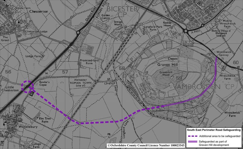
- Southern peripheral corridor: provide a South East Perimeter
Road to support the significant housing and employment growth in
Bicester. In the longer term, link capacity issues along Boundary Way
are assessed as being a major transport issue for the town. Land is
safeguarded at Graven Hill for the section of road to the south of this
site, joining the A41 at the Pioneer Road junction – this prevents
development on the land that would be required, but does not remove
the need for full assessment, justification and planning processes to
be undertaken. This will need extending westwards to join the A41
north of M40 Junction 9. The preferred alignment for this extension
has been approved as a connection from the Little Chesterton
junction across to Graven Hill (see Bicester Figure 2). The solution
will also include a new link through the South East Bicester
development site from the A41 Pioneer Road junction up to
Wretchwick Way, providing connectivity through the site, in particular
for buses.
Investigating solutions to East-West Rail Phase 2 challenges. More rail
traffic means that there is more disruption to the road network where the two
cross. A new rail bridge at Charbridge Lane is already being planned, but there
are other challenges such as the rail crossing at London Road where options
need to be developed further. We are:
- Working closely with the rail industry to deliver solutions at the
Charbridge Lane level crossing affected by the East-West Rail
Project. A dual carriageway road bridge over the railway at
Charbridge Lane is critical for this crucial part of the highway to
remain open. We are working with the rail industry to deliver an
effective solution that meets the overall transport strategy in terms
of the peripheral route corridor and considers the impact on the
village of Launton.
- Working closely with the rail industry and the Department for
Transport to develop a solution to the likely restrictions
affecting the London Road as a result of the East-West Rail
project and national rail programme. The increased rail traffic as
a result of the significant rail network improvements will significantly
restrict access at the London Road level crossing in the future. We
are exploring options to identify a preferred solution to retain
vehicular and pedestrian access at that crossing. The County
Council will work with partners and central government departments
to identify funding and establish a delivery programme for this
preferred solution.
Supporting the proposals to secure a potential freight interchange at
Graven Hill and working with the district and developers to achieve this.
This would reinforce Bicester as a distribution hub within the region’s economy
_____________________________________________________________________
Page 18 of 85Connecting Oxfordshire: Volume 8 Part ii Updated 2016
_____________________________________________________________________
and make a significant contribution to the future employment provision in
Bicester, especially in the Graven Hill site, which in itself could provide 26 ha of
employment land. The south east quadrant of Bicester is viewed to be the most
appropriate area for B8 employment uses given the strategic road and rail
access. The facility would also assist in removing freight traffic on the M40,
A34 and A43, further reducing strain on the strategic road network and
benefiting the environment.
.
13. Providing the above infrastructure and connections will be critical to
attracting employment growth in Bicester, especially for the peripheral
development sites. Effective transport links between the residential areas,
employment sites and other facilities will facilitate economic growth, and
provide more opportunities for people to live and work in Bicester, thus
reducing the current level of out-commuting. The reduction in the length of
people’s journeys provides opportunities for them to use non-car modes of
travel. Complementary investment in the town’s bus, walking and cycling
network will have an essential role in accommodating growth, encouraging
sustainable travel choices, and raising the quality of the environment.
Combining walking or cycling with bus/rail as outlined in the Door to Door
section of the Active & Healthy Travel Strategy will be a key element of this.
14. A Sustainable Transport Strategy for Bicester has been developed by
Cherwell District Council and has particularly concentrated on the cycle
infrastructure improvements and changing travel behaviour towards more
sustainable travel. The principles are embedded within this overall transport
strategy.
15. Cycle-friendly measures must be incorporated into all new road schemes and
new housing developments. It is essential that new developments are planned
with cycling in mind and with facilities to make cycling both convenient and
safe. This will link in with developing a connected, comprehensive cycle
network across the town.
16. We will review walking networks and focus capital improvements on routes
with the greatest potential for increasing the numbers of people walking,
particularly where improving the pedestrian environment would support
economic growth and reduce car use. We will also prioritise strategically
important walking routes for maintenance.
17. Bus connectivity improvements may be required at anticipated pinch points
within the town as future developments come forward. This will include
connections between North West Bicester and the town centre.
BIC2 – We will work to reduce the proportion of journeys made by private car
through implementing the Sustainable Transport Strategy by:
Significantly improving public transport connectivity with key areas of
economic growth within Oxfordshire, through access to high-quality, high
_____________________________________________________________________
Page 19 of 85Connecting Oxfordshire: Volume 8 Part ii Updated 2016
_____________________________________________________________________
frequency services on the core network between Bicester, Oxford, Banbury,
Witney and Science Vale, operating on a ‘turn up and go’ basis throughout the
day; integrated connections between local bus services and services on the
core network; and flexible, cashless payment, with the ability to switch
between modes of travel without penalty or the need to make separate
payments.
Where possible, we will encourage and support bus operators’ proposals to
develop innovative bus services and alternative routes, especially more direct
and express services; for example a strategic bus link between south-east of
Bicester and Oxford Eastern Arc.
Improving Bicester’s bus services along key routes and providing
improved public transport infrastructure considering requirements for and
integrating strategic development sites. Working with Bicester Town Council
we will also enhance passenger information at strategic locations. The aim is
to connect residential areas and transport hubs with existing and future
employment centres including, but not limited to:
- Graven Hill;
- North West Bicester;
- Launton Road Industrial estate;
- Bicester Business Park;
- South-East Bicester;
- North-East Bicester;
- Town centre; and
- Bicester Village.
Growth at Upper Heyford will also need to be considered in terms of improved
public transport frequency and connectivity with Bicester.
Bus connectivity improvements may be required at anticipated pinch points
within the town as future developments come forward. This will include
connections between North West Bicester and the town centre and consider
the need for bus lanes along the A41 to connect with the Park and Ride
scheme.
This will be supported by using funding from development to enhance the
quality and frequency of existing services, with the aim of services reaching full
commercial viability.
Enhancing pedestrian, cycle and public transport links to the Bicester
Village Station, Bicester North Station and key employment sites.
Sustainable access between the railway stations and business areas will also
be improved and promoted to attract businesses to locate in Bicester. New
employment should be located where there are effective, reliable, frequent and
well-timed bus and rail services and safe and appropriate cycle access.
Accessibility should be considered not only to and from the sites within the
town itself, but also to key external destinations.
_____________________________________________________________________
Page 20 of 85Connecting Oxfordshire: Volume 8 Part ii Updated 2016
_____________________________________________________________________
In particular, making use of the opportunities offered by the redevelopment of
Bicester Village Railway Station to create a ‘state-of-the-art’ multi-modal
interchange offering high quality facilities, including a cycle hub incorporating
hire and repairs will be considered further. We will also improve the walking
route between the station and the town centre, as well as creating a new
walking route linking the station with Langford Village, the expanded Bicester
Village outlet and the Kingsmere estate.
An essential element of mitigating Bicester Village’s impact is to improve
connectivity with the local area through walking and cycling route
improvements to key destinations. This in combination with Highway and
Public Transport Infrastructure improvements, such as the new Bicester Park
and Ride, will reduce the local impact in the area.
Securing green links will be considered between proposed development sites
on the outskirts of the town and existing Public Rights of Way, providing a
series of leisure / health walks. We will also pursue opportunities to join a
number of missing links in the Public Rights Of Way network through working
with developers.
Implementing Bicester town centre highway modifications. In
combination with improvements to the peripheral routes, highway restrictions in
Bicester Town Centre will be considered on through routes in order to reduce
through traffic in the town centre, constraining it to the peripheral routes and
promoting more sustainable travel options in the town. Radial connectors into
the town centre will be assessed in terms of their role in the overall transport
network and opportunities for providing improvements for sustainable modes of
transport.
A review of the purpose and impact of the Buckingham and Banbury Road
chicanes will be undertaken to understand whether they have a positive impact
on reducing town centre through traffic movements anymore, particularly for
HGVs. If there is no clear benefit, they shall be removed.
Public realm improvement studies will be progressed for Bicester Market
Square and The Causeway to investigate enhancing the quality of the
pedestrian environment by creating a sense of ‘place’. This will complement
the major investment in the town centre redevelopment and will be progressed
once other developments impacting on the Market Square are completed.
The Bicester Sustainable Transport Strategy has identified a number of
new sections of urban pedestrian and cycle routes to better connect
residential developments with the town centre and key employment
destinations. This work and other strategy work has included the need for*:
- Consideration of off road cycle facilities along key cycle routes;
- Central Corridor pedestrian/cycle improvements along the A41, Oxford
Road, Kings End, Queens Avenue;
- Development of a preferred option for a pedestrian/cycle shared use facility
_____________________________________________________________________
Page 21 of 85Connecting Oxfordshire: Volume 8 Part ii Updated 2016
_____________________________________________________________________
along Buckingham Road between its junctions with Field Street and
Churchill Road. Options such as a shuttle working system under the rail
bridge for vehicular traffic will be assessed, as the width of highway is
constrained at this point;
- Churchill Road pedestrian/cycle improvements improving connectivity,
particularly for Cooper School;
- The provision of an off-road cycle facility along Middleton Stoney Road to be
assessed, as this route will become increasingly heavily trafficked in the
coming years;
- A direct link from the centre of North West Bicester (Eco Town) to Bicester
North Station and onwards to the Launton Road industrial estate;
- Improved cycle provision on the north side of Boundary Way to provide clear
connectivity benefits;
- Options for relaxing the cycle ban on Sheep Street will be investigated as
this could be a key route for cyclists, particularly between the two railway
stations;
- Improved pedestrian connections to Graven Hill including A41 crossing
options to reduce severance and increase the accessibility of this site;
- London Road pedestrian/cycle improvements, improving connectivity to
Graven Hill;
- Improved provision for cyclists along Manorsfield Road;
- Investigating options for good quality connectivity to Launton Road
employment destinations;
- Reviewing potential locations for additional cycle parking at key locations
and bus stops, particularly in the town centre.
* This is not an exhaustive list and other projects may come forward for
addition to the Plan.
Progressing a Wayfinding Project for Bicester with the aim of improving
signage across the town. The current wayfinding signs in Bicester were
introduced over 10 years ago. There is a mix of freestanding signs, map based
signs and “finger” signs, both pole and wall mounted. These are often in poor
condition, occasionally in the wrong place and expensive to update and
maintain. Some are out of date and no longer adequate for their purpose.
Inadequate signage creates a poor impression of the town centre, can be
frustrating for those trying to navigate the town and does little to support
businesses and tourism.
However, good wayfinding can greatly enhance the visitors’ experience, can
facilitate an increased number of visitors to key destinations within the town
centre and can support local businesses which are of increasing importance to
Bicester’s economy and regeneration. As a result, Bicester requires expansion
of and where necessary updating of the existing signage for pedestrians and
cyclists.
_____________________________________________________________________
Page 22 of 85Connecting Oxfordshire: Volume 8 Part ii Updated 2016
_____________________________________________________________________
18. The strategy supports the achievement of national carbon reduction targets by
minimising the need to travel, and getting more people to walk, cycle or use
public transport instead of driving, which not only reduces emissions, but also
supports growth by helping to meet the overall demand for travel, and
reducing congestion. We will also support the uptake of zero and low
emission vehicles for both private and public transport.
19. The Eco Bicester Travel Behaviour Demonstration Project showed that
working closely with a small number of adults to get them back into cycling
was effective. The Bike Loan element of this project has now been taken on
by the community through Bicester Green – the Centre for ‘Sustainability,
Skills and Second Hand Stuff’. It is clear that a combination of behavioural
change, as well as physical improvements, is required to really make a
difference. The Sustainable Transport Strategy is identifying ways to continue
with influencing behaviour.
BIC3 – We will increase people’s awareness of the travel choices available in
Bicester, which should improve public health and wellbeing, by:
Undertaking travel promotions and marketing measures to complement
the wider Bicester Vision place-making initiatives to strengthen the town as a
place to live, work and invest in commercial enterprises. With the Park and
Ride and significant rail service improvements due to be available over the
next few years, there is an opportunity to work collaboratively with others to
promote these modes. Developer’s Travel Plans will also offer the
opportunity to increase the use of walking, cycling and public transport
measures by increasing people’s awareness of the travel choices available.
Developing a coordinated parking strategy in partnership with Cherwell
District Council to identify commuter parking areas and provide an
appropriate balance of parking provision in the town and around the railway
stations, including the quantity and location of short stay and long stay
parking, as well as appropriate parking management and pricing
mechanisms. This may require rationalising parking in some areas.
Discourage undesirable routeing of traffic by developing a signage
strategy, improving the directional signage on the town’s road network by
directing strategic traffic away from the town centre. This will alleviate
congestion on the central corridor and enhance the quality of the environment
in the town centre. It will also support Cherwell District Council’s emerging Air
Quality Strategy, which aims to tackle air pollution in the Kings End / Queens
Avenue Air Quality Management Area.
Providing coordinated information and advance notice of construction
closures and traffic related issues will be needed to ensure that the town’s
transport network operates efficiently during the various improvement and
building works. A strategic system of Variable Message Signs for Bicester
could support this coordinated approach and so will be investigated. Such a
system could also be used on event days in Bicester and coordination of the
_____________________________________________________________________
Page 23 of 85You can also read