Cottingham Neighbourhood Plan - Cottingham Neighbourhood Plan 2021 - 2031 (proposed)
←
→
Page content transcription
If your browser does not render page correctly, please read the page content below
Cottingham Neighbourhood Plan
2021 – 2031 (proposed)
Cottingham Neighbourhood Plan
                       2020 – 2035
July 2021
             Pre-Submission Version
Page left deliberately blank
Contents
Foreword ............................................................................................................................................. 3
1.         Introduction ............................................................................................................................. 4
2.         How the Neighbourhood Plan fits into the Planning System .................................................. 5
3.         The Plan, its vision, aims and what we want it to achieve ........................................................ 6
4.         How the Plan was prepared ..................................................................................................... 7
5.         Our Parish................................................................................................................................. 9
6.         Meeting the requirement for sustainable development....................................................... 12
7.         Neighbourhood Plan Policies ................................................................................................. 13
7.1        Housing and the Built Environment....................................................................................... 13
7.1.1. Strategy for growth ................................................................................................................ 13
7.1.2. The Community’s View .......................................................................................................... 14
7.1.3 Housing Allocations ............................................................................................................... 15
7.1.4. The Settlement Boundary ...................................................................................................... 17
7.1.5. Windfall Development ........................................................................................................... 18
7.1.6. Housing mix ........................................................................................................................... 19
7.1.7. Single plot exception sites ..................................................................................................... 20
7.1.8. Housing Design ...................................................................................................................... 21
8.         The Natural and Historic Environment .................................................................................. 24
8.1.       Landscape, geology and setting ............................................................................................. 24
8.2.       Historic environment ............................................................................................................. 24
8.3.       Natural environment ............................................................................................................. 25
8.4.       Existing environmental designations ..................................................................................... 25
8.5.       Environmental inventory ....................................................................................................... 26
8.6.       Local Green Spaces ................................................................................................................ 26
8.7.       Natural environment ............................................................................................................. 27
8.7.1 Sites of natural environment significance ............................................................................. 27
8.7.2 Biodiversity and habitat connectivity .................................................................................... 28
8.8.1 Sites of historical environment significance .......................................................................... 30
8.9.       Buildings and structures of local significance ........................................................................ 31
8.9.1. Statutorily protected features ............................................................................................... 31
8.9.2. Local Heritage Assets ............................................................................................................. 32
8.9.3. Ridge and furrow ................................................................................................................... 33
8.10. Important Open Spaces ......................................................................................................... 36
8.11. Managing flood risk ............................................................................................................... 37
8.12. Important views ..................................................................................................................... 39

                                                                           1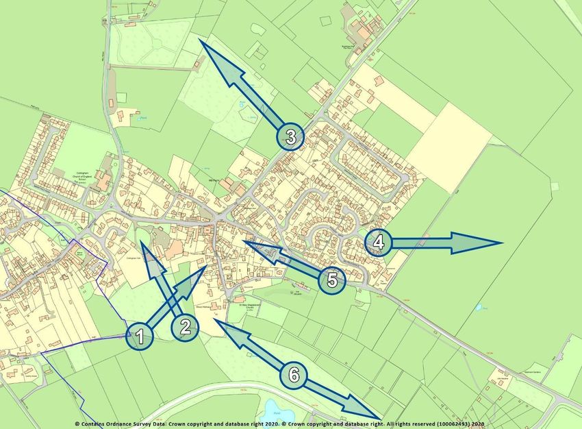
8.13. Footpaths and bridleways ..................................................................................................... 41
8.14. Renewable energy generation infrastructure ....................................................................... 42
9.        Community Assets ................................................................................................................. 43
9.1.      Drawing the community together ......................................................................................... 43
9.2.      Community Assets ................................................................................................................. 43
9.3       New or Improved Community Facilities and Amenities ........................................................ 46
9.4.      Parish Communications - Keeping connected ....................................................................... 46
9.4.1. Broadband and mobile infrastructure ................................................................................... 46
9.5.      Transport and Road Safety .................................................................................................... 47
9.5.1. A safe and connected parish.................................................................................................. 47
9.5.2. School parking........................................................................................................................ 48
9.5.3. Parking – private cars/residents ............................................................................................ 48
9.5.4. Yellow lines ............................................................................................................................ 48
9.5.5. Delivery vehicles .................................................................................................................... 48
9.5.6. Speeding ................................................................................................................................ 49
9.5.7. Electric vehicles...................................................................................................................... 49
9.5.8. Public transport and disability ............................................................................................... 50
9.5.9. Condition of Parish Roads ...................................................................................................... 50
9.6.      Business and Employment - Helping the community to thrive ............................................. 51
9.6.1. Support for Existing Businesses and Employment ................................................................ 52
9.6.2. Support for new businesses and employment ...................................................................... 52
9.6.3. Home working........................................................................................................................ 53
9.6.4. Farm Diversification ............................................................................................................... 54
9.7.      Tourism .................................................................................................................................. 55
10.       Monitoring and review ............................................................................................................ 56
Policy Index                                                                                                                                       57
                                                            Appendices

1. Basic Condition Statement                                           8. 8.
                                                    Environmental Inventory and Scoring
                                                    System
2     Consultation Statement                  9. 9. Local Green Spaces
3.    Census Data                             1010. Local Heritage Assets
4.    Design Guide                            1111. Important Views
5.    Affordable Housing for Sale report      112. Field References
6.    Housing Needs Report and Midlands Rural 1313. Large Map Section
      Housing Survey
7.    Site Sustainability Assessments

                                                                          2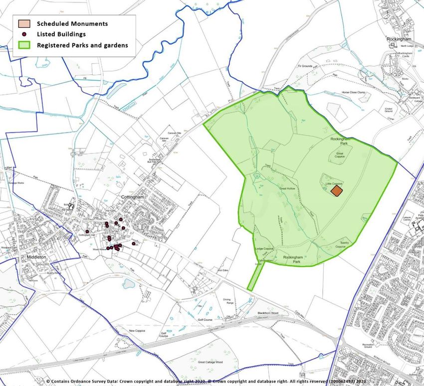
Foreword
The Localism Act of November 2011 introduced new rights and powers to allow local
communities to shape new development by coming together to prepare Neighbourhood
Plans. Local people now have a greater say about what happens in the area in which they
live by preparing a Neighbourhood Plan that sets out policies that meet the needs of the
community whilst having regard for local and national strategic planning policies.
Cottingham’s Neighbourhood Development Plan takes its lead from national legislation,
the Joint Planning and Delivery Unit Joint Core Strategy and Corby Borough Council
through its Part 2 Local Plan, now at Submission. However, it has a local focus aimed at
protecting the village’s history and heritage.

The process of creating the Cottingham Neighbourhood Plan has been driven by Parish
Councillors and members of the community. The aim of this Neighbourhood Plan is to put
forward the wishes of the community regarding future development and to deliver local
aspirations within the context of the strategic planning framework.

Cottingham is a small rural village with a long history dating back to before the Doomsday
Book with evidence of Roman and pre-Roman occupation. It is mentioned in the Anglo-
Saxon Chronicles and was part of Rockingham Forest, a Medieval forest created by William
1st Cottingham is a rural community near Corby which is a larger urban area. The village
has a conservation area and enjoys extensive views over the attractive Welland Valley.
Additionally, Cottingham is close to Rockingham Castle and Rockingham Estates are
landowners whose land lies partly within the village, it is also adjacent to Middleton with
which it shares a Parish Boundary. The village comprises a number of distinctive
characteristics including sixteen listed buildings and a large number of unlisted but
nevertheless important heritage assets.

The village has a Village Hall Annexe with a new Community Hub to be called the Mill
being developed. This new facility, which has received planning permission, will serve both
Cottingham and Middleton. There is a community owned and run Village Store and Café,
the Parish owns a particularly attractive pocket park known as The Dale and Cottingham
and Middleton support a Community Newsletter. All this evidences a strong community
ethos. The Plan aims to ensure the village develops whilst retaining its rural character and
enhancing the quality of life for its residents.

We are grateful to Officers from Corby Borough Council who have supported us through
the process and to our community for engaging so enthusiastically in the process. The
Parish Council wishes to express sincere thanks to all the Parishioners who kindly
contributed to the development of the Neighbourhood Plan. The perseverance of the
various teams who have contributed to this Plan during the trying time created by the Covid
19 Pandemic is appreciated. Cottingham is an attractive and popular place in which to live
and the contribution from people who care about their community and want to make it
better for generations to come is welcomed.
Cllr David Grayson, Chair, Cottingham Parish Council

                                              3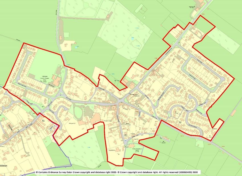
1. Introduction
A Neighbourhood Plan is a new type of planning document that gives local people greater control
and say over how their community develops and evolves. It is an opportunity for local people to
create a framework for delivering a sustainable future for the benefit of all who live or work in that
community, or who visit it.
As the Plain English Guide to the Localism Act 2011 states, “Instead of local people being told what
to do, the Government thinks that local communities should have genuine opportunities to
influence the future of the places where they live”.
It enables a community to create a vision and set clear planning policies for the use and
development of land at the neighbourhood level to realise this vision. This includes, for example,
where new homes, shops and industrial units should be built, what new buildings and extensions
should look like and which areas of land should be protected from development.
Neighbourhood Plans can be general or more detailed, depending on what local people want. They
must, however, be in general conformity with Borough-wide planning policies, have regard for
national planning policies and must be prepared in a prescribed manner.
Comments are welcomed through the pre-submission consultation process and will be taken on
board and the Neighbourhood Plan amended where appropriate. it will then be submitted to Corby
Borough Council who will first undertake a validation check to ensure that the appropriate
documents have been included and the correct processes followed, before consulting on it further
and submitting it for Independent Examination where the Plan will be tested for conformity with a
range of ‘Basic Conditions’:
it must have appropriate regard for national policy;
it must contribute towards the achievement of sustainable development;
it must be in general conformity with the strategic policies of the development plan for the
local area;
it must be compatible with human rights requirements and
it must be compatible with EU obligations.
After that it will be put forward to referendum, where those on the electoral register in Cottingham
Parish will be invited to vote on whether or not they support it. Over 50% of those voting must
vote yes for it to become a ‘Made’ statutory planning document.
After being ‘Made’, each time a planning decision has to be taken by Corby Borough Council or any
other body, in Cottingham Parish, they will be required to refer to the Cottingham Neighbourhood
Plan (alongside the Borough’s own Local Plan and other relevant documents) and check whether
the proposed development is in accordance with the policies in this Neighbourhood Plan.
4
2. How the Neighbourhood Plan fits into the Planning System
The right for communities to prepare Neighbourhood Plans was established through the Localism
Act 2011, which set out the general rules governing their preparation.
A Neighbourhood Plan forms part of the statutory Development Plan for the area in which it is
prepared. This statutory status means that it must be taken into account when considering
planning decisions affecting that area.
A Neighbourhood Plan is not prepared in isolation. It also needs to be in general conformity with
relevant national as well as strategic policies set out in the Local Plan, which in this case is the
North Northamptonshire Joint Core Strategy (JCS) 2011-2031 adopted in July 2016 which is the
Part 1 Local Plan covering the Boroughs of Corby, East Northamptonshire, Kettering and
Wellingborough.
For Cottingham, in addition to the JCS, the Part 2 Local Plan for Corby, due to be adopted in 2021,
has also been considered. However, the Part 2 Local Plan does not contain strategic planning
policies and as such there is no requirement for the Neighbourhood Plan to be in conformity with
it. Rather, the JCS sets out the strategic planning framework for the District’s future development
up to 2031. It contains a number of policies and objectives which are relevant to Cottingham and
which the Neighbourhood Plan must be in general conformity with. These policies and objectives
span issues such as the provision and location of new housing; providing strong and sustainable
communities; protecting and enhancing historic character and local distinctiveness whilst
protecting and enhancing natural habitats; and providing transport systems that reduce the need
to travel. The Neighbourhood Plan is in general conformity with the policies contained in the JCS.
Also important is the National Planning Policy Framework (NPPF) updated in July 2019. This sets
out the Government's planning policies for England and how these are expected to be applied.
The NPPF requires the planning system (including Neighbourhood Plans) to promote sustainable
development and details three dimensions to that development: an economic dimension:
they should contribute to economic development; a social dimension
they should support strong, vibrant and healthy communities by providing the right supply
of housing and creating a high quality built environment with accessible local services and
an environmental dimension
they should contribute to protecting and enhancing the natural, built and historic
environment.
In addition, Neighbourhood Plans must be compatible with European Union (EU) legislation.
Relevant EU obligations in relation to the neighbourhood planning process are those relating to
Strategic Environmental Assessments, protected European Habitats and Human Rights Legislation.
Following the UKs withdrawal from the EU, the above provisions have been incorporated into UK
law. This situation will be reviewed as the precise arrangements for the UK leaving the UK evolve.
This Plan and the policies it contains are consistent with the NPPF, North Northamptonshire Joint
Core Strategy and relevant EU legislation. Furthermore, these policies are specific to Cottingham
and reflect the needs and aspirations of the community.
It is important to note that not having a Neighbourhood Plan does not mean that development
5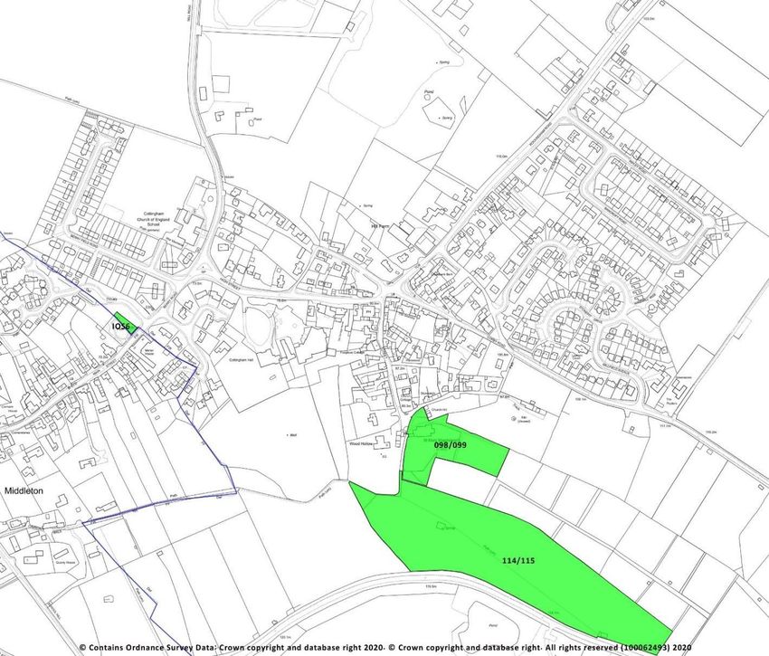
won’t happen. Development would still take place, but without the policies in this Plan, which set
out the type of development that is in keeping with our area’s character. Decisions would instead
be primarily based on the Borough’s policies rather than local criteria.
3. The Plan, its vision, aims and what we want it to achieve
The Plan area encompasses the whole of the Parish of Cottingham and covers the period up to
2031. It is our vision that:
Development reflects the general character of the village, with its conservation area, and in
line with both Local and National strategies and as far as possible to ensure that development
meets locally identified need and the requirements of a “green” economy ensuring a high-
quality communication network;
traffic and parking issues are managed to ensure the safety of pedestrians, cyclists, horse
riders and walkers as well as motorists;
locally appropriate employment is welcomed;
the green environment is protected from inappropriate development;
community facilities meet local need and are accessible to all.
Flowing from the vision statement is a range of objectives that help support its delivery:
a) To provide a balanced range of housing choices which meet the diverse needs of all
generations, by increasing the supply of smaller homes and homes for elderly ‘down-sizers’;
b) To encourage high-quality design reflecting the rural character of the village;
c) To protect and improve the provision of current facilities and assets which contribute to a
vibrant community spirit, and to promote the development of new community facilities which
enhance and enrich community life;
d) To safeguard the most valued and ‘special’ green areas in the parish from inappropriate
development and to enhance the biodiversity characteristics of the parish;
e) To promote development that is safe and that respects the character of neighbouring
properties and preserves the rural aspect of the village providing a strong ‘sense of place’;
f) To ensure that all listed buildings and any identified community or environmental heritage
‘assets’ are protected and improved where possible.
6
4. How the Plan was prepared
The Parish Council decided to undertake the formulation of a Neighbourhood Plan for Cottingham
and appointed neighbourhood plan consultants ‘YourLocale’ to advise and assist the Council
through the process.

The mandate was to drive the process, consult with the local community, gather evidence to
support the development of policies and deliver the plan.

The work undertaken built on the Parish Plan which was published in 2009 and the Housing Needs
Survey of Cottingham which was prepared in December 2017.

All Parishioners were invited to an initial
Consultation Day which was held on 11th
May 2019 in the Village Hall Annexe. The
purpose of the Consultation was to find
out which aspects of life in the village
were important and highly valued, and
which, if any, needed to change. A series
of display boards and large-scale village
maps were set out in the hall with each
focusing on a topic relating to planning
and development in Cottingham.

                                              7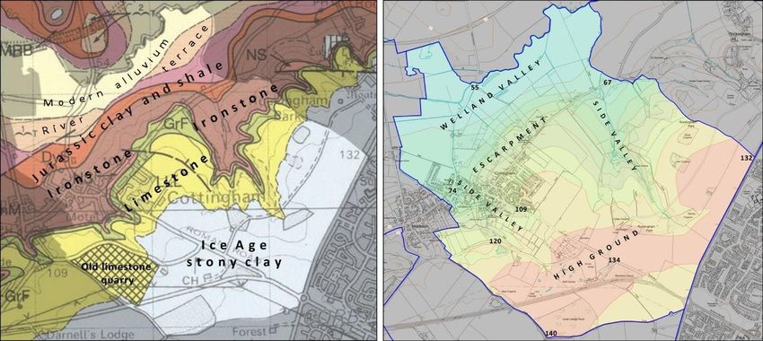
The event was a great success with 51 people in attendance
                                 providing important input into the future development of the
                                 Plan. A summary of the responses is available in the supporting
                                 information. There was a very lively and engaging atmosphere.

                                  Three ‘Theme Groups’ were launched on 17 June 2019. Parish
                                  Councillors and residents came together to consider in detail
                                  the potential policy areas relating to 1) housing and the built
                                  environment, 2) the natural and historic environment and 3)
                                  Community sustainability (including community facilities;
                                  employment and transport).

                                   The groups met throughout 2019 and into 2020.

                                   The sections which contain the policies within this
                                   Neighbourhood Plan emerged through this process.
                                    The finalisation of the Plan was complicated by the onset of
                                    the Covid-19 Pandemic which disrupted arrangements for
                                    community engagement prior to the formal Regulation 14
                                    and Regulation16 processes.

Details of the progress of the Plan were shared with the community through direct mailings and by
using social media.

                                                8
5. Our Parish
The Plan area comprises the whole of the Parish of Cottingham, within the Borough of Corby, as
shown in figure 1. High resolution versions of all figures are available in the supporting information.
The area was formally designated by Corby Borough Council on 4th June 2015.
Figure 1 – Parish of Cottingham – Designated Area
95.1 History of Cottingham
The history of Cottingham was described in detail in the 2009 Parish Plan as follows: Cottingham is
a village of considerable natural beauty and antiquity, nestling in the foot of the Welland Valley
and part of the medieval Rockingham Forest.
The village’s history can be traced back to pre-Roman times, lying along the route of the ’Via
Devana’ Roman Road from Colchester to Chester. The
village is recorded in the Domesday Book of 1086, then
owned by Peterborough Abbey, and is mentioned in the
Anglo-Saxon Chronicle (1197).
The Parish Church of St Mary Magdalene dates back to the
13th Century. A Methodist Church opened in 1808, later to
become the Methodist Hall when the larger present chapel
was built alongside in 1878.
Also, still to be found in the village are the remains of a circa 18th Century limekiln, a late 18th
Century windmill, a former clothing factory originally opened by Wallis and Linnell in 1874 and the
Grade ll* Bury House (now Cottingham Hall)dating back to the 1690s.
5.2 Environment
Cottingham is surrounded by beautiful countryside with the ancient Jurassic Way footpath running
right through the village.
‘The Dale’ - a peaceful, secluded natural meadow owned by the village which is home to a wide
variety of native plants and trees - lies on the south side of the village, just behind St Mary
Magdalene Church.
5.3 Houses
There are approximately 368 houses in the village, being a mixture of ironstone cottages dating
from the 13th to 19th Centuries and modern dwellings mostly built around the 1950s/60s.
5.4 People
According to a village survey, undertaken during the
preparation of the Parish Plan, the main reasons for
moving to Cottingham were ranked as:
love of village/country life,
working within a commutable distance,
getting married/setting up home,
to be near to relatives,
for a period/character property
social life within village.
Of the families that have moved to the village, most (65%) have moved from within a 10-mile
10radius. 14% have moved from within an 11 to 30-mile radius and 21% have moved from 31 miles
away or more.
5.5 Education
Cottingham and the nearby villages of Middleton, Rockingham and East Carlton are served by
Cottingham Church of England Primary school, providing education for primary and junior school
age children.
5.6 Census Profile
At the time of the 2011 Census, the Cottingham Parish was home to around 912 residents living in
363 households. Analysis of the Census suggests that between 2001 and 2011 the population in
the local area declined by around 1%. During this period, it is estimated the number of dwellings
increased by 6.
There is an over-representation of older people and evidence of an ageing population with the
number of over 65-year olds rising between 2001 and 2011 by 18% and up from 18% of total
population to 21% in 2011. In line with national trends the local population is likely to get older as
average life expectancy continues to rise.
Home ownership levels are very high with around 80% of households owning their homes outright
or with a mortgage or loan and at 8% the share of households living in social rented
accommodation is very low when compared with regional and national rates. There is evidence of
under-occupancy suggesting a need for smaller homes of one to two bedrooms which would be
suitable for residents needing to downsize, small families and those entering the housing market.
Providing suitable accommodation for elderly residents will enable them to remain in the local
community and release under-occupied larger properties onto the market which would be suitable
for growing families.
There is a predominance of large detached houses and an under-representation of housing for
single people with just 4% of dwellings having one bedroom. Land Registry data indicates no new
build housing market activity over recent years. Deprivation is not a significant issue in the local
area.
Home ownership is dominant in Cottingham and affordable rental properties may be difficult to
access for people on low incomes.
Further census information can be seen in Appendix 3
116. Meeting the requirement for sustainable development
The NPPF states that there are three dimensions to sustainable development: social,
environmental and economic, all of which are important and interrelated. Policy 1 of the Joint
Core Strategy sets out a locally distinctive interpretation of para 11 of the NPPF on what the
presumption in favour of sustainable development means for plan-making and decision-taking.
6.1 Social
We have sought, through the neighbourhood plan, to safeguard existing open space for the future
enjoyment of residents.
We are also seeking to protect existing community facilities and to deliver a mix of housing types
so that we can meet the needs of present and future generations and ensure that we support the
community’s needs and its health, social and cultural wellbeing.
6.2 Environmental
In order to protect and enhance our natural, built and historic environment, we are seeking to
ensure that housing development is of the right type in the right location, so that it does not harm
but instead positively reflects the existing historic character of the area in order to:
Protect the village identity and conserve the rural nature of its surroundings;
Recognise the need to protect and, where possible, improve biodiversity and important
habitats; and
Provide for improved pedestrian facilities.
6.3 Economic
Whilst the built-up parts of the parish of Cottingham are primarily residential, there is a significant
commercial element within the parish and a desire to ensure that appropriate economic activity is
maintained as long as the local infrastructure supports it. We therefore wish to encourage
employment opportunities in our area by:
Supporting appropriate existing business development and expansion where the local
infrastructure would not be adversely affected by the proposals; and
Encourage start-up businesses and home working.
This document sets out local considerations for delivering sustainable development across
Cottingham Parish. Development proposals should meet the requirements of all relevant policies
in the Local Development Plan.
127. Neighbourhood Plan Policies
MAPS
The maps in the Neighbourhood Plan have been included at reduced size to provide context
for the policies and to indicate the locations of sites and features. Larger size maps can be seen
in Appendix 13.
7.1 Housing and the Built Environment
7.1.1. Strategy for growth
This Plan promotes new residential development and conversion of existing dwellings as a positive
choice to ensure the vibrancy of the parish and continued support for schools, community facilities
and commercial services.
To ensure that the Neighbourhood Plan followed a robust process, a number of local residents
came together after a well-attended consultation day in the parish to form a Housing Theme Group
(HTG). The HTG was facilitated by a member of the consultancy support team from YourLocale, the
neighbourhood plan consultants engaged by the Parish Council.
The first task of the HTG was to consider the overall planning policy approach agreed in the 2016
adopted Joint Core Strategy (JCS) by Corby Borough Council (CBC), Kettering Borough Council, East
Northants Council and Wellingborough Borough Council. This JCS forms part 1 of the Local Plan.
The JCS sets out an ambitious growth programme between 2011 and 2031 with a requirement of
9,200 new residential units and this will be exceeded as 12,044 units are planned. An over delivery
of around 30% (see North Northamptonshire monitoring report) of the requirement to 2031 is
currently being achieved by the four respective councils who are in the process of merging
together to form one unitary council and simultaneously taking over the functions of
Northamptonshire County Council for the north region of the county.
Part 2 of the Local Plan (LP) for CBC was submitted for examination in December 2019. The LP
approach is to continue to use the overall policy direction adopted in the JCS and to agree a rural
housing delivery policy. The JCS seeks to deliver 120 new homes in the rural area of Corby (including
Cottingham) between 2011 and 2031 to support sustainable development. As identified in the
Regulation 19 publication draft, sufficient sites have been identified to meet the requirement for
the rural area and these are expected to be supplemented by additional sites that continue to
come forward under the provisions of the JCS to enhance or maintain the vitality of rural
communities. To quote the 2019 LP submission; “Due to progress against the rural requirement, it
is not considered necessary to make any allocations for development in the rural area within the
Local Plan or to identify specific targets for individual settlements. However further allocations
could come forward through neighbourhood plans or rural exception sites, in particular to meet
local needs identified in Rural Housing Need Surveys or demand for self-build developments”.
In order to better understand local housing need, the HTG analysed a range of available evidence
and commissioned its own studies to support the emerging Neighbourhood Plan policies.
13A strategic housing market assessment (SHMA) study was completed for CBC in 2012 and partially
reviewed in 2015, this outlined a Borough-wide approach to meeting future housing need but did
not provide evidence at an individual parish level. To develop further intelligence at the parish
level, in August 2017 CBC commissioned a rural housing needs survey for Cottingham. It was
undertaken by a specialist rural housing consultant and was completed in December 2017 (see
Appendix 6). The survey was circulated to 428 parish households and 93 responses were
received;Housing Needs Reprto this provided a satisfactory response rate of 22% and makes the
results statistically valid. Details of the housing needs survey report are available within the
assessment of affordable housing for sale as Appendix 5. A Housing Needs Report of Cottingham
was undertaken in 2017 (Appendix 6). Together, these documents provide much of the evidence
for the emerging policies.
One of the key aims of the Plan is to deliver the necessary housing construction required to meet
the housing needed in the parish to 2031. Although no “formal” housing target is required by CBC
up until the end of the current planning period, the Parish Council has confirmed its desire to be
ambitious and support community aspirations by allocating sites for eight to ten units, an
allocation higher than that suggested by the 2017 Housing Needs Report.
The principal aim of the HTG has therefore been to consider the current housing situation and
deliver the future housing provision that is required to meet the needs of the parish in a holistic
fashion.
7.1.2. The Community’s View
From the information gathered from the introductory exhibition held on 11th May 2019, it is clear
that villagers do not want large scale housing developments in or around the village. However,
there has been an expressed desire to consider housing development which is designed to meet
the needs of young families, the elderly and the needs of people who wish to continue residing in
the village. The general opinion supports affordable housing and showed clear preferences for
housing types and characteristics for new developments. Most respondents showed a strong
desire to cater for the needs of single people, younger families, people trying to access the property
ladder and those wishing to down-size. Almost half of the recorded preferences favoured the
inclusion of more low-cost, social and affordable rented or shared ownership and a similar
proportion felt that the parish would benefit from more bungalows and accessible housing.
The clear message gleaned from the open event and the housing needs survey evidence is that the
community seeks to encourage a continued vibrancy and diversity, both suggest that adjusting the
housing offer will best achieve this objective. Cottingham’s Plan aims to meet this requirement
within the context of a rural village with a clearly defined conservation area, and giving
consideration to its setting within the Welland Valley and the fact that it adjoins Middleton Village
and Rockingham Estates.
147.1.3 Housing Allocations
To help identify the most appropriate locations for further residential development, a
comprehensive Site Sustainability Assessment (SSA) process was undertaken. The following flow
chart shows the steps that have been taken to ensure that a full and transparent assessment
process was undertaken, described in full as Appendix 7.
Site Sustainability Assessment process
Assessment Resource
Check local opinion regarding Initial consultation exercise
perceived housing need.
Local and national requirements for National Government Housing Policies, North
housing. Northants Joint Core Strategy, Part 2 Local Plan
for Corby (submission document).
Area under consideration. Cottingham Parish and village boundaries,
Conservation Area boundaries, Survey of
landowners.
Cottingham demographics. 2011 Census plus perceived changes in age
groups.
Current Cottingham Housing Stock New builds, current housing levels, tenure,
and comparison with local area. comparisons with local area, Census 2011 and
Corby BC planning
Initial housing requirement for the
duration of the Neighbourhood
Plan.
Landowners adjacent to the village boundary,
Call for sites. questionnaire and letter requesting
information about future possible building.
Assessment of site suitability. Use of site assessment matrix applied to all
returns.
Inform landowners of decision and
allow time for appeal.
Modify assessment if required.
Check deliverability of housing Inform landowners of decision and allow time
proposals. for appeal
15A local “call for sites” was undertaken and advertised widely by the Parish Council in September
and October 2019. A letter and questionnaire was sent to all known local landowners with fields
adjacent to the village settlement boundary and site sponsors identified from a recent similar
exercise undertaken by CBC. Eight positive returns offering development land were received. Two
sites met all the requirements. However, public opinion concerning the loss of a view over the
Welland Valley dictated that only the site at Hill farm would be acceptable to residents.
POLICY H1: RESIDENTIAL SITE ALLOCATION
Land is allocated at Hill Farm Cottingham as shown on the site plan below (Figure 2,
area shaded blue).
This will be supported subject to:
1. the development will not exceed ten dwellings and will provide
Affordable Housing as defined under clauses 2 and 3 below;
2. the proposals provide on-site Affordable Housing for shared ownership,
shared equity, affordable rent and social rent provision that meets the
identified needs of people with established local connections;
3. the development is subject to an agreement which will ensure that the
Affordable Housing stock remains as Affordable Housing in perpetuity;
4. up to two of the total units may be open market housing but only where it
can be demonstrated to be essential to ensure the delivery of affordable
housing as part of the same development;
5. the development is appropriate, in terms of scale, character and location,
and adheres to the design criteria promoted in accordance with this Plan.
6 the existing the foul sewer infrastructure is protected by easements and
should not be built over or located in private gardens1.
Figure 2 Residential allocations (App12 shows OS field references)
16……………………………………………………………
1
If this is not possible a formal application to divert Anglia Water’s existing assets may be required.
7.1.4. The Settlement Boundary
The purpose of a Settlement boundary is to ensure that sufficient housing and economic activity is
available in appropriate locations that will avoid overloading the transport infrastructure and
intruding into the local countryside.
Settlement boundaries were established by CBC in order to clarify where new development is
usually best located. They are used to define the extent of a built-up part of a settlement and
distinguish between areas where, in planning terms, development is acceptable in principle, such
as in the main settlement and where it would be less acceptable, generally in the least sustainable
locations such as in the open countryside. Focusing development within the agreed Settlement
boundary will help to support existing services within the village and help to protect the
countryside and the remainder of the Plan area from inappropriate development.
Figure 3 – Settlement Boundary
17POLICY H2: SETTLEMENT BOUNDARY - Development proposals within the plan area
on sites within the Settlement boundary, or in terms of new sporting or recreational
facilities close or adjacent to the Settlement boundary as identified on the map
(Figure 3), will be supported where they respect the shape and form of Cottingham
and comply with the policies of this plan.
Land outside the defined Settlement boundary will be treated as open countryside,
where development will be carefully controlled in line with local and national strategic
planning policies.
In keeping with paragraph 1.36 of the modified Part 2 Plan for Corby, on adoption, the
Neighbourhood Plan for Cottingham will supersede the Part 2 Local Plan for Corby
where policies such as site allocations or alterations to the settlement boundaries
apply.
7.1.5. Windfall Development
Windfall sites are small infill or redevelopment sites that come forward unexpectedly. These sites
can comprise redundant or vacant buildings including barns, or gaps between existing properties
in a built-up area.
Such sites have made a regular contribution towards the housing supply in the parish. There remain
several small site opportunities for windfall development within the Settlement boundary and it is
recognised that they will continue to make an important contribution to housing provision over
18the lifetime of the plan.
Cottingham’s Neighbourhood Plan will adopt the following definition of Windfall Sites defined in
NPPF “Sites which have not been specifically identified as available in the Local Plan process. They
normally comprise previously-developed sites that have unexpectedly become available”.
POLICY H3: WINDFALL SITES - Applications for windfall development will be
supported subject to proposals being well designed and meeting all relevant
requirements set out in other policies in this Plan and District-wide planning policies
and where such development:
a) Is within the Settlement boundary for Cottingham;
b) Helps to meet the identified housing requirements in terms of housing mix;
c) Retains, wherever possible, existing important natural boundaries such as trees,
hedges and streams;
d) Does not reduce garden space to an extent where it adversely impacts on the
character of the area, or the amenity of neighbours and the existing and future
occupiers of the dwelling(s);
e) Provides safe pedestrian and vehicular access to the site;
f) Respects the shape and form of the village in order to maintain its distinctive
character and enhance it where possible.
7.1.6.Housing mix
The Census data suggests evidence of an ageing population with the number of people aged 65
and over increasing by 18% between 2001 and 2011. Over 65s represented 18% of total
population in 2001 rising to 21% by 2011. Research shows the number of older people will grow
significantly in the future and relative growth will be highest in older cohorts.
Further analysis of the Census data shows the majority (50%) of residential dwellings are detached
which is somewhat higher than the borough (21%), regional (32%) and national (22%) shares.
Around two thirds (30%) of households live in houses with four or more bedrooms which is
significantly higher than the borough (18%), regional (20%) and national (19%) averages. There is
an under-representation of housing for single people with just 4% of dwellings having one bedroom
against 6% for the borough, 8% for the region and 12% for England as a whole.
Under-occupancy in the local area is particularly evident in larger properties with around 45% of
households with 4 or more bedrooms occupied by just one or two people. This is higher than
borough (39%), regional (43%) and England (41%) rates.
The age structure of the population of Northamptonshire is forecast to change over the plan
period, with significant implications for the homes, jobs, services and facilities that are required.
(See Appendix 6). It is anticipated that the growth in working age population is relatively modest
but that there will be significant expansions in 60+ age groups (the number of people over 75 is
forecast to increase by 92%). This will increase the demand for specialised provision such as
designated, sheltered and extra-care housing and will also increase pressure on health and social
19services. It also creates the potential for large scale downsizing from under-occupied homes. At the
other end of the age range, there will be a significant growth in the number of children (27%
increase in 0-14 age group). School places will be needed for this expanding population.
Applying this logic to Cottingham, the 194 residents over the age of 65 could become as high as
374 (approximately 40% of the village population) and of the 0 to 14 age group the current 131
residents could become 166.
This Plan seeks to re-balance the future housing mix by requiring a minimum percentage of
affordable, lower cost and smaller units. If left to the market, evidence suggests that more large
and expensive housing will be developed, which is neither wanted by the local community nor
needed locally. Building more accessible, smaller housing will help reduce under-occupancy and
free up older, larger houses in the village for re-sale to families.
POLICY H4: HOUSING MIX - New housing development shall provide a mixture of
housing types which meets identified current local needs in Cottingham Parish.
Development incorporating new dwellings of three or fewer bedrooms and/or single
storey accommodation suitable for older people will be supported, whilst dwellings
of four or more bedrooms will be supported only where they are subservient in
number to any one, two or three-bedroom accommodation in any development.
7.1.7. Single plot exception sites
The NPPF (2019) defines affordable housing as ‘housing for sale or rent, for those whose needs are
not met by the market (including housing that provides a subsidised route to home ownership
and/or is for essential local workers)’. The definition goes on to list different types including
affordable housing for rent (including social rent); starter homes, discounted market sale housing
and other affordable housing routes to home ownership.
Exception sites are in locations which would not normally obtain planning permission for new
housing development. The exception is justified to meet a locally identified need for affordable
housing for local people.
Two specific studies explored the need for affordable housing in Cottingham. The Housing Needs
Survey (2017) and the Affordable Housing for Sale Report (2020) both identified a need for
affordable housing locally.
The headline result of the housing needs survey was that a total of six additional properties were
required to be provided between 2018 and 2023, two open market or sale units, two shared
ownership units and two affordable rented units. Much of the major development that has taken
place since the 1950s in the parish has provided family homes of three and four bedrooms. Recent
schemes in particular have capitalised on the area’s geographic location, facilities and desirability
by offering a greater percentage of higher-end, expensive large homes for outright purchase.
According to returns provided by Estate Agents the average house price in Cottingham is around
20£290,000. House price data provided by the Land Registry would put the average price
somewhat lower at around £250,000.
The Affordable Housing for Sale report concluded that the high house prices in Cottingham,
coupled with low levels of affordable housing (and NO ownership models of affordable housing),
alongside current evidence of need, demonstrate the importance of providing a range of
affordable housing products.
The high property prices locally mean that subsidised home ownership or rental products offering
a discount of around 20% on current values would probably still be unaffordable to most people.
It recommended that consideration should be given to developing shared ownership products
which allow people to buy a share of the dwelling from around 25% of its value, with the ability to
staircase up as circumstances change.
Supporting the provision of affordable housing exception sites will ensure that dwellings will have
permitted development rights removed and future sale of the property will be controlled through
a planning obligation to ensure that it remains as an affordable property for local people in
perpetuity.
POLICY H5: SINGLE PLOT AFFORDABLE EXCEPTION SITES - Such sites will be supported
for custom and self-build in the parish provided that the proposal is in accordance
with policy 13 of the Joint Core Strategy and:
a) The applicant is the prospective occupier of the proposed dwelling;
b) The applicant has a strong and evidenced local connection to the village; and
c) The applicant has an identifiable housing need which cannot be met on the
open market.
d) dwellings will have permitted development rights removed and future sale of
the property will be controlled through a planning obligation to ensure that
the property remains affordable in perpetuity.
In keeping with paragraph 1.36 of the modified Part 2 Plan for Corby, on adoption, the
Neighbourhood Plan for Cottingham will supersede the Part 2 Local Plan for Corby
where policies such as site allocations or alterations to the settlement boundaries
apply.
7.1.8. Housing Design
Cottingham is mentioned in the 1068 Doomsday Book. Its history dates back to at least Roman
times lying as it does on Via Devana Roman road which ran from Colchester to Chester. The Anglo-
Saxon Chronicles (1197) show that the village was the property of Peterborough Abbey and was
part of Rockingham Forest, a Medieval Forest created by William the 1st. The forest declined under
the reigns of Charles the 1st and Charles the 2nd and was disbanded in 1832.
21Considering its long history, the number of residents changed very little from the early 18th century
when it had a population of 623 to 631 at the end of the century. Whilst this population figure
decreased after the First World War it has steadily risen to over 900 today. From the early 18th
century the population of England has risen six-fold whilst Cottingham in comparison has risen by
approximately 50%. The Parish of Cottingham therefore has a long and interesting history,
resulting in a wide array of heritage assets, attractive landscapes and a distinctive local character.
This is reflected in the designation of a Conservation Area covering the village.
The biggest challenge facing the future of Cottingham is to balance the desire to protect the
character of the village with the need for it to grow and evolve in a sensitive and proportionate
manner to sustain the community and its facilities.
The policy in this section seeks to reflect the design principles which the community believes will
help to achieve this aim. It reflects the outcome of consultations of all age groups, of community
organisations and of the Housing Theme Group which specifically focused on relevant issues – all
of which showed broad unanimity of views. The overall aim is to protect Cottingham so that it
retains its character within a unique and distinctive Parish. This can be achieved by the use of the
planning system to respond sensitively to the wide range of historic buildings, structures,
landscapes and archaeology situated within the Parish. These assets form many of the key
characteristics of the Parish, and future development should seek to enhance, reinforce and
preserve this distinctive historic environment.
New development proposals should be designed sensitively to sit within the distinctive settlement
patterns of the village. Existing settlement patterns have grown incrementally over time. The
buildings date from many different periods, providing a richness and variety of styles and materials.
This traditional rural character should be enhanced by new development and schemes which are
designed to ensure that new buildings sit comfortably within the existing settlement pattern and
are respectful of their surroundings.
The community consider it to be important that new residential development is of the highest
standard so as to be in keeping with the majority of residential properties in the village. It is not
considered necessary to have a uniform series of properties that all look the same, rather to
ensure that new developments respect the features of buildings which make Cottingham a
desirable place in which to live.
POLICY H6: HOUSING DESIGN - Development proposals should demonstrate a high quality
of design, layout and use of materials in order to make a positive contribution to
retaining the special character of the Parish. Development proposals must pay regard to
the Cottingham Design Guide (See appendix 4) where appropriate and subject to
viability considerations. New development should enhance and reinforce the local
distinctiveness and character of the area in which it is situated and proposals should
clearly show how the general character, scale, mass, density and layout of the site,
building or extension fit in with the aspect of the surrounding area. Care should be taken
to ensure that the development does not disrupt the visual amenities of the street scene
or impact negatively on any significant wider landscape views;
22POLICY H6: HOUSING DESIGN (continued)
a) New development should reflect the character and historic context of existing
developments within the Parish. However, contemporary and innovative materials and
b) New development should enhance and reinforce the local distinctiveness and character
of the area in which it is situated and proposals should clearly show how the general
character, scale, mass, density and layout of the site, building or extension fit in with the
aspect of the surrounding area. Care should be taken to ensure that the development
does not disrupt the visual amenities of the street scene or impact negatively on any
significant wider landscape views;
c) New development should reflect the character and historic context of existing
developments within the Parish. However, contemporary and innovative materials and
design will be supported where positive improvement can be robustly demonstrated
without detracting from the historic context;
d) Redevelopment, alteration or extension of historic farmsteads and agricultural buildings
within the Parish should be sensitive to retaining their distinctive character, materials
and form;
e) Development should enhance biodiversity and relate well to the topography of the area,
with existing trees and hedges preserved whenever possible. Provision should be made
for wildlife including roof design, bird boxes and the use of hedges;
f) Where possible, enclosure of plots should be of native hedging, wooden fencing with
hedgehog friendly openings, or stone/brick wall. Any enclosures that are necessarily
removed through the development process should be reinstated in keeping with the
original;
g) Housing plots should accommodate waste and recycling storage containers compliant
with the refuse collection system;
h) Development should incorporate sustainable design and construction techniques to
meet high standards for energy and water efficiency, including the use of renewable and
low carbon energy technology;
i. Development should incorporate sustainable drainage systems with
maintenance regimes to minimise vulnerability to flooding and climate change;
j) Off-road parking or, for houses, garaging of a size suitable for family cars should be
provided to at least meet Highway Authority requirements, sited so as to be unobtrusive
and not a dominant feature of the street scene. Adequate off-road parking should be
provided as a minimum of two car parking spaces for dwellings of three bedrooms or
fewer and three spaces for dwellings of four bedrooms or more; and
k) All new dwellings should have access to high speed broadband.
l) Housing retrofit designed for low carbon measures will be encouraged.
238. The Natural and Historic Environment
8.1. Landscape, geology and setting
Cottingham lies on the southeast side of the Welland Valley, a regionally significant topographic
feature, with the meandering river at its centre marking the boundary between Northamptonshire
and Leicestershire. The floodplain is some two kilometres wide, with large flat fields that
historically have been marshes or water meadows. The valley sides are (by East Midlands
standards) steep and high the difference in elevation across the Plan Area is 85m giving residents
a number of extensive views both across the valley (including highly-valued summer sunsets) and
of the village from all directions. Two side valleys cut southwards into the escarpment and high
ground forming the south part of the parish, both of them being characteristic landscape features
(‘dales’) of the village itself.
The Plan Area is underlain by rocks of Jurassic age (about 175 million years old) whose layers have
been revealed by erosion of the escarpment: clay and shale at the bottom, ironstone on the hillside
and limestone at the top. The underlying limestone of the highest ground, in the southeast, has a
thick covering of glacial stony clay, left here by ice sheets that covered England about 300,000
years ago. Cottingham village was established on the hillside, above the floodplain and away from
the heavy clay, on the better-drained ironstone and limestone; both of the latter have provided
the characteristic stone for the local vernacular buildings.
Figure 4: Geology (left) and topography of the Plan Area
© Contains Ordnance Survey Data: Crown copyright and database right 2020. © Crown copyright and database right. All rights reserved (100062493) 2020
8.2. Historic environment
Archaeological finds show that people were present in prehistoric times. A likely villa site close to
the Via Devana Roman Road, whose course is still followed by Corby Road, School Lane and the
footpath beside the playing field, is likely to have been associated with a Romano-British farming
community.
24You can also read