COUNTY DEVELOPMENT PLAN 2021-2027 - NATURA IMPACT REPORT APPROPRIATE ASSESSMENT DRAFT LOUTH
←
→
Page content transcription
If your browser does not render page correctly, please read the page content below
NATURA IMPACT REPORT
                              IN SUPPORT OF THE

                APPROPRIATE ASSESSMENT

                                    FOR THE

                  DRAFT LOUTH
       COUNTY DEVELOPMENT PLAN 2021-2027

for:      Louth County Council
          County Hall
          Millennium Centre
          Dundalk
          County Louth

by:       CAAS Ltd.
          1st Floor
          24-26 Ormond Quay Upper
          Dublin 7

                               OCTOBER 2020
Appropriate Assessment of the Draft Louth County Development Plan 2021-2027
Table of Contents
Introduction ...................................................................................................... 1
1.1 Background .......................................................................................................................1
1.2 Legislative Context .............................................................................................................1
1.3 Approach...........................................................................................................................1
Description of the Draft Plan ............................................................................ 3
Screening for Appropriate Assessment............................................................. 5
3.1 Introduction to Screening ...................................................................................................5
3.2 Identification of Relevant European Sites .............................................................................5
3.3 Assessment Criteria and Screening ......................................................................................8
3.4 Other Plans and Programmes ............................................................................................ 12
3.5 AA Screening Conclusion................................................................................................... 12
Stage 2 Appropriate Assessment .................................................................... 14
4.1 Introduction..................................................................................................................... 14
4.2 Characterisation of European Sites Potentially Affected ........................................................ 14
4.3 Identifying and Characterising Potential Significant Effects ................................................... 14
Mitigation Measures........................................................................................ 21
Conclusion ....................................................................................................... 28
Appendix I Background information on European Sites
Appendix II Relationship with Other Plans and Programmes
CAAS for Louth County Council iAppropriate Assessment of the Draft Louth County Development Plan 2021-2027
List of Tables
Table 3.1 Screening of European Sites within 15 km of the County ..................................................9
Table 4.1 Characterisation of Potential Effects arising from the Plan .............................................. 17
Table 5.1 Measures most relevant to the protection of European Sites ........................................... 22
List of Figures
Figure 3.1 European Sites within 15 km of the County and Rivers and Catchments ...........................7
Figure 3.2 Screening for Appropriate Assessment Determination ................................................... 13
CAAS for Louth County Council iiAppropriate Assessment of the Draft Louth County Development Plan 2021-2027
Introduction
1.1 Background
This Natura Impact Report (NIR) has been prepared in support of the Appropriate Assessment (AA) of
the Draft Louth County Development Plan 2021-2027 in accordance with the requirements of Article
6(3) of Council Directive 92/43/EEC on the Conservation of Natural Habitats and of Wild Fauna and
Flora (as amended) (hereafter referred to as the “Habitats Directive”).
This report is part of the ongoing AA process that is being undertaken alongside the preparation of the
Plan. It will be considered, alongside other documentation prepared as part of this process, when Louth
County Council finalises the AA at adoption of the Plan.
1.2 Legislative Context
The Habitats Directive provides legal protection for habitats and species of European importance. The
overall aim of the Habitats Directive is to maintain or restore the “favourable conservation status” of
habitats and species of European Community Interest. These habitats and species are listed in the
Habitats and Birds Directives (Council Directive 2009/147/EC on the conservation of wild birds) with
Special Areas of Conservation (SACs) and Special Protection Areas (SPAs) designated to afford
protection to the most vulnerable of them. These two designations are collectively known as European
Sites (also known as Natura 2000 sites).
AA is required by the Habitats Directive, as transposed into Irish legislation by the European
Communities (Birds and Natural Habitats) Regulations 2011 (as amended) and the Planning and
Development Act 2000 (as amended). AA is an assessment of the potential for adverse or negative
effects of a plan or project, in combination with other plans or projects, on the conservation objectives
of a European Site. These sites consist of SACs and SPAs and provide for the protection and long-term
survival of Europe’s most valuable and threatened species and habitats.
1.3 Approach
The AA is based on best scientific knowledge and has utilised ecological and hydrological expertise. In
addition, a detailed online review of published scientific literature and grey literature1 was conducted.
This included a detailed review of the National Parks and Wildlife (NPWS) website including mapping
and available reports for relevant sites and in particular sensitive qualifying interests/special
conservation interests described and their conservation objectives.
The ecological desktop study completed for the AA of the Plan comprised the following elements:
Identification of European Sites within 15 km of the Plan boundary with identification of potential pathway links for
specific sites (if relevant) greater than 15 km from the Plan boundary;
Review of the NPWS site synopsis and conservation objectives for European Sites with identification of potential
pathways from the Plan area; and
Examination of available information on protected species.
There are four main stages in the AA process as follow:
Stage One: Screening
The process that identifies the likely impacts upon a European Site of a project or plan, either alone or in combination
with other projects or plans and considers whether these impacts are likely to be significant.
Stage Two: Appropriate Assessment
The consideration of the impact on the integrity of the European Site of the project or plan, either alone or in
combination with other projects or plans, with respect to the site’s structure and function and its conservation
objectives. Additionally, where there are adverse impacts, an assessment of the potential mitigation of those impacts.
1
Various documents where publishing, in journals for example, is not the primary activity of the producing body. Examples
include: conference presentations; regulatory data; unpublished trial data; government publications; and dissertations/theses.
CAAS for Louth County Council 1Appropriate Assessment of the Draft Louth County Development Plan 2021-2027
If adequate mitigation is proposed to ensure no significant adverse impacts on European Sites, then the process may
end at this stage. However, if the likelihood of significant impacts remains, then the process must proceed to Stage
Three.
Stage Three: Assessment of Alternative Solutions
The process that examines alternative ways of achieving the objectives of the project or plan that avoids adverse
impacts on the integrity of the European Site.
Stage Four: Assessment where no alternative solutions exist and where adverse impacts remain
An assessment of compensatory measures where, in the light of an assessment of imperative reasons of overriding
public interest (IROPI), it is deemed that the project or plan should proceed.
The Habitats Directive promotes a hierarchy of avoidance, mitigation and compensatory measures. This
approach aims to avoid any impacts on European Sites by identifying possible impacts early in the plan-
making process and avoiding such impacts. Second, the approach involves the application of mitigation
measures, if necessary, during the AA process to the point where no adverse impacts on the site(s)
remain. If potential impacts on European Sites remain, the approach requires the consideration of
alternative solutions. If no alternative solutions are identified and the plan/project is required for
imperative reasons of overriding public interest, then compensation measures are required for any
remaining adverse effect(s).
The assessment of potential effects on European Sites is conducted following a standard source-
pathway-receptor2 model, where, in order for an effect to be established all three elements of this
mechanism must be in place. The absence or removal of one of the elements of the model is sufficient
to conclude that a potential effect is not of any relevance or significance.
In the interest of this report, receptors are the ecological features that are known to be utilised by the
qualifying interests or special conservation interests of a European Site. A source is any identifiable
element of the Plan provision that is known to interact with ecological processes. The pathways are any
connections or links between the source and the receptor. This report provides information on whether
direct, indirect and cumulative adverse effects could arise from the Plan.
The AA exercise has been prepared taking into account legislation including the aforementioned
legislation and guidance including the following:
Appropriate Assessment of Plans and Projects in Ireland. Guidance for Planning Authorities, Department of the
Environment, Heritage and Local Government, 2009;
"Commission Notice: Managing Natura 2000 sites - The provisions of Article 6 of the 'Habitats' Directive 92/43/EEC",
European Commission 2018;
“Assessment of plans and projects significantly affecting Natura 2000 sites: Methodological guidance on the provisions
of Article 6(3) and (4) of the Habitats Directive 92/43/EEC”, European Commission Environment DG, 2002; and
“Managing Natura 2000 sites: The Provisions of Article 6 of the Habitats Directive 92/43/EEC”, European Commission,
2000.
2
Source(s) – e.g. pollutant run-off from proposed works; Pathway(s) – e.g. groundwater connecting to nearby qualifying wetland habitats; and
Receptor(s) – qualifying aquatic habitats and species of European Sites.
CAAS for Louth County Council 2Appropriate Assessment of the Draft Louth County Development Plan 2021-2027
Description of the Draft Plan
The Draft Louth County Development Plan is a land use plan and overall strategy for the proper planning
and sustainable development of the functional area of County Louth over the six-year period 2021-2027.
Not later than four years after the adoption of the Plan, the Council is required to review it and
commence the preparation of a new Plan.
The Plan includes a Written Statement, that provides the development policies, Core Strategy and
mandatory and discretionary objectives for different policy areas addressed by the Development Plan.
The Plan is set out over five volumes as follow:
Volume One: The Written Statement which sets out the overall strategy alongside the policies and objectives of the
Draft Plan to ensure the proper planning and sustainable development of the County.
Volume One A: Strategic maps and zoning maps providing a graphic representation of the proposals of the Draft Plan
indicating land use and other objectives of the Council including for the County, the Regional Growth Centres of
Drogheda and Dundalk, and the Self-Sustaining Growth Towns of Ardee and Dunleer.
Volume Two: Strategic maps and zoning maps providing a graphic representation of the proposals of the Draft Plan
indicating land use and other objectives of the Council for the Level 3 - Self-Sustaining Towns, Level 4 -Small Towns
and Villages and Level 5 - Rural Villages.
Volume Three: The Appendices which include the Housing and Retail Strategies, Green Infrastructure Strategy, ACA’s
and ZAP’s etc.
Volume Four: The Record of Protected Structures
Volume Five: The Strategic Environmental Assessment (SEA) Environmental Report, the Appropriate Assessment (AA)
Natura Impact Report and the Strategic Flood Risk Assessment (SFRA) Report
The Written Statement is divided into 14 separate chapters setting out various policies and objectives
under the headings of:
1. Introduction
2. Core Strategy and Settlement Strategy
3. Housing
4. Social and Community
5. Economy and Employment
6. Tourism
7. Movement
8. Natural Heritage, Biodiversity and Green Infrastructure
9. Built Heritage and Culture
10. Infrastructure and Public Utilities
11. Environment, Natural Resources and the Coast
12. Climate Action
13. Development Management Guidelines
14. Implementation and Monitoring
The Plan’s Strategic Vision is to:
Promote County Louth, in particularly the regional growth centres of Drogheda and Dundalk, as uniquely
attractive places in which to live, work, visit, and do business and where the quality of employment and
educational opportunities, natural and built environment, cultural experiences and provision of inclusive
communities are to the highest standards.
The Vision for County Louth will be achieved through realisation of the following Strategic
Objectives:
SO 1 Realise the potential and promote the development and growth of County Louth through harnessing the
economic and employment potential of the competitive advantages of the County. This includes its strategic location,
connectivity and accessibility to external markets and having regard in particular to the role of Drogheda and Dundalk
as Regional Growth Centres located on the Dublin-Belfast Economic Corridor.
SO 2 Support and promote the role of Drogheda and Dundalk as key designated Regional Growth Towns with high
levels of self-sustaining employment and services, to act as regional economic drivers, playing a significant role for a
wide catchment area and to help achieve a more coordinated and sustainable settlement and travel pattern across the
region.
CAAS for Louth County Council 3Appropriate Assessment of the Draft Louth County Development Plan 2021-2027
SO 3 Direct new development in accordance with the Core and Settlement Strategies, which will provide for the
sustainable development of the County for the period 2021-2027 and beyond and in accordance with the principles of
compact growth, consolidation and regeneration.
SO 4 Transition to a low carbon and climate resilient County supporting energy efficiency and reducing energy
demand, through a combination of mitigation and adaptation responses to climate change. This includes for increased
usage of renewable energy through developing indigenous energy resources supporting the transition to a low carbon
economy by 2050 and ensuring flood risk management.
SO 5 Ensure a more sustainable and integrated concept of development with regard to land use, transportation,
water services, energy supply and waste management over the lifetime of the Plan.
SO 6 Conserve and enhance the County’s Green Infrastructure and ecosystem services supporting the sustainable
management of natural assets and the biodiversity of the County’s protected habitats and species to provide a wide
range of environmental, social and economic benefits to communities.
SO 7 Protect and enhance the built, cultural and natural heritage assets of Louth, the intrinsic value of which helps
to define the character of both urban and rural areas, contributes to the attractiveness, vibrancy and sense of place
for residents, tourists and visitors, including improved access to the countryside through the development of
greenways, walking trails and blueways in support of and advancing sustainable communities.
SO 8 Develop and support vibrant, inclusive, sustainable and healthy communities in Louth where people can live,
work, invest and visit, enjoying access to a wide range of community, health and educational facilities and amenities,
suitable for all ages and needs, in both urban and rural areas, thereby supporting a high quality of life for all to enjoy.
SO 9 Protect and enhance the unique character and identity of Louth’s towns and villages and improve quality of
life and well-being through the application of Healthy Place-making, underpinned by good urban design with the
creation of attractive public spaces that are vibrant, distinctive, safe and accessible and which promote and facilitate
positive social interaction.
SO 10 Support implementation of the objectives and actions for strengthening economic and community
development in the County in accordance with the Louth Local Economic and Community Plan.
SO 11 Support the further development of a resilient economic base in Louth and promote both enterprise and
entrepreneurship, underpinned by innovation and talent resulting in the delivery of sustainable jobs and economic
growth.
SO 12 Support improvements in and access to education and training as central to skills, knowledge, innovation
and quality job creation which will underpin future prosperity for all and aid in achieving a more sustainable, balanced
and inclusive society.
SO 13 Support the sustainable development of rural areas that are under strong urban influence to avoid over-
development, while sustaining vibrant rural communities.
SO 14 Reverse rural decline in small towns and villages through sustainable, targeted measures addressing vacancy
and delivering sustainable reuse and regeneration outcomes.
SO 15 Ensure the proper integration of transportation and land use planning through the increased use of
sustainable transport modes and the minimisation of travel demand to achieve a sustainable, integrated and low carbon
transport system with excellent connectivity both within and beyond the County.
SO 16 Ensure the efficient and sustainable use and development of water and waste water service infrastructure
throughout the County in a manner that supports a healthy society, economic development and a cleaner environment.
SO 17 Facilitate the development of infrastructural projects, which will underpin sustainable development
throughout the County during the period of the Plan.
SO 18 Afford suitable protection to the environment and natural resources of the County and ensure the fulfilment
of environmental responsibilities.
SO 19 Provide a framework for the management and regulation of development and use of land that will guide day
to day planning decisions, thus ensuring a more sustainable and integrated concept of development with regard to all
forms of land use.
CAAS for Louth County Council 4Appropriate Assessment of the Draft Louth County Development Plan 2021-2027
Screening for Appropriate Assessment
3.1 Introduction to Screening
This stage of the process identifies any potential significant effects to European Sites from a project or
plan, either alone or in combination with other projects or plans.
An important element of the AA process is the identification of the “‘conservation objectives”,
“Qualifying Interests” (QIs) and/ or “Special Conservation Interests” (SCIs) of European Sites requiring
assessment. QIs are the habitat features and species listed in Annexes I and II of the Habitats
Directive for which each European Site has been designated and afforded protection. SCIs are wetland
habitats and bird species listed within Annexes I and II of the Birds Directive. It is also vital that the
threats to the ecological / environmental conditions that are required to support QIs and SCIs are
considered as part of the assessment.
The following NPWS Generic Conservation Objectives have been considered in the screening:
For SACs, to maintain or restore the favourable conservation condition of the Annex I habitat(s) and/or the Annex II
species for which the SAC has been selected; and
For SPAs, to maintain or restore the favourable conservation condition of the bird species listed as Special Conservation
Interests for this SPA.
Where available, Site-Specific Conservation Objectives (SSCOs) designed to define favourable
conservation status for a particular habitat3 or species4 at that site have been considered.
3.2 Identification of Relevant European Sites
The Department of the Environment (2009) Guidance on AA recommends a 15 km buffer zone to be
considered. A review of all sites within this zone has allowed a determination to be made that in the
absence of significant hydrological links, the characteristics of the Plan will not impose effects beyond
the 15 km buffer.
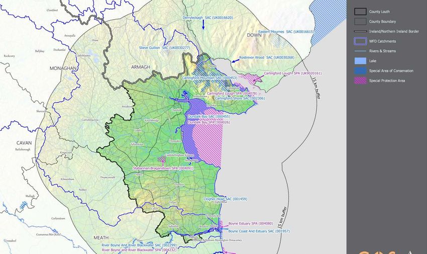
Details of European Sites that occur within 15 km of the Plan is listed in Table 3.1. European Sites and
Rivers and Catchments are also mapped in Figure 3.1 below. Information on QIs, SCIs and site-specific
vulnerabilities and sensitivities (see Appendix I) and background information (such as that within
Ireland’s Article 17 Report to the European Commission, site synopses and Natura 2000 standard data
forms) has been considered by both the AA screening assessment (provided under this section) and
Stage 2 AA (provided under Section 4). Conservation objectives that have been considered by the
assessment are included in the following National Parks and Wildlife (NPWS) and Joint Nature
Conservation Committee (JNCC) documents:
NPWS (2018) Conservation Objectives for Carlingford Mountain SAC [IE0000453] Version 6.
NPWS (2011) Conservation Objectives for Dundalk Bay SAC [IE0000455] Version 1.
NPWS (2017) Conservation Objectives for Clogher Head SAC [IE0001459] Version 1.
NPWS (2012) Conservation Objectives for Boyne Coast and Estuary SAC [IE0001957] Version 1.
NPWS (2018) Conservation Objectives for River Boyne and River Blackwater SAC [IE0002299] Version 6.
NPWS (2013) Conservation Objectives for Carlingford Shore SAC [IE0002306] Version 1.
NPWS (2011) Conservation Objectives for Dundalk Bay SPA [IE0004026] Version 1.
NPWS (2013) Conservation Objectives for Carlingford Lough SPA [IE0004078] Version 1.
NPWS (2013) Conservation Objectives for Boyne Estuary SPA [IE0004080] Version 1.
NPWS (2018) Conservation Objectives for Stabannan-Braganstown SPA [IE0004091] Version 6.
NPWS (2018) Conservation Objectives for River Nanny Estuary and Shore SPA [IE0004158] Version 6.
NPWS (2018) Conservation Objectives for River Boyne and River Blackwater SPA [IE0004232] Version 6.
3
Favourable conservation status of a habitat is achieved when: its natural range, and area it covers within that range, are stable or increasing; the
specific structure and functions which are necessary for its long-term maintenance exist and are likely to continue to exist for the foreseeable
future; and the conservation status of its typical species is favourable.
4
The favourable conservation status of a species is achieved when: population dynamics data on the species concerned indicate that it is maintaining
itself on a long-term basis as a viable component of its natural habitats; the natural range of the species is neither being reduced nor is likely to
be reduced for the foreseeable future; and there is, and will probably continue to be, a sufficiently large habitat to maintain its populations on a
long-term basis.
CAAS for Louth County Council 5Appropriate Assessment of the Draft Louth County Development Plan 2021-2027
JNCC (2017) Conservation Objectives for Eastern Mournes SAC [UK0016615] Version 2.
JNCC (2015) Conservation Objectives for Derryleckagh SAC [UK0016620] Version 2.
JNCC (2015) Conservation Objectives for Rostrevor Wood SAC [UK0030268] Version 2.
JNCC (2015) Conservation Objectives for Slieve Gullion SAC [UK0030277] Version 2.1.
JNCC (2015) Conservation Objectives for Carlingford Lough SPA [UK9020161] Version 3.
The assessment considers available conservation objectives. Since conservation objectives focus on
maintaining the favourable conservation condition of the QIs/SCIs of each site, the screening process
concentrated on assessing the potential effects of the Plan against the QIs/SCIs of each site. The
conservation objectives for each site were consulted throughout the assessment process.
CAAS for Louth County Council 6Appropriate Assessment of the Draft Louth County Development Plan 2021-2027 Figure 3.1 European Sites within 15 km of the County and Rivers and Catchments CAAS for Louth County Council 7
Appropriate Assessment of the Draft Louth County Development Plan 2021-2027
3.3 Assessment Criteria and Screening
3.3.1 Is the Plan Necessary to the Management of European Sites?
The overarching objective of the Plan is not the nature conservation management of the sites, but to
coordinate and plan the future development of County Louth. Therefore, the Plan is not considered to
be directly connected with or necessary to the management of European Sites.
3.3.2 Elements of the Draft Plan with Potential to Give Rise to Effects
The Plan provides a framework for the sustainable development of the Louth area. Plan elements that
could potentially affect the integrity of European Sites include:
Provisions for sectors such as transport, urbanisation, streetscape works, community facilities, utilities, natural
resource, coastal, tourism and recreation development that introduce sources for effects through construction phase
such as habitat destruction, light pollution, hydrological interactions and disturbance effects; and
Loading pressures from the operational phase of developments – these sources could result in habitat loss, disturbance
effects, interactions with water quality and/habitat fragmentation.
The elements of the Draft Plan with the highest potential to give rise to the effects indicated above are
generally associated with construction phase elements of the implementation of the Plan. The
operational phase elements of the Plan are generally consistent with the existing condition of the area;
however, these will also need to be carefully considered. All policies and objectives are considered in
this assessment with respect to the ecological integrity of each of the European Sites identified. The
assessment considers the sensitivities/vulnerabilities of the QIs and SCIs in relation to all potential
sources for effects and potential pathways for such effects. Where sources and pathways for effects
are identified, potential effects are assessed in relation to the SSCOs.
3.3.3 Screening of Sites
Table 3.1 examines whether there is potential for effects on European Sites considering information
provided above, including Appendix I. Sites are screened based on one or a combination of the following
criteria:
The existence of potential for pathways for significant effects, such as hydrological links, Plan proposals and the site
to be screened;
The distance of the relevant site from the County boundary; and
The existence of a link between identified threats or vulnerabilities at a site to potential impacts that may arise from
the Plan.
CAAS for Louth County Council 8Appropriate Assessment of the Draft Louth County Development Plan 2021-2027
Table 3.1 Screening of European Sites within 15 km of the County
Site European Distance Qualifying Features Potential effects (refer also to Sections 3.3.2 and 3.3.3 above) Potential Potential
Code Site (km) (Qualifying Interest and Special Conservation Interests) Pathway for In-
for Combinati
Significant on Effects?
Effects?
000453 Carlingford 0 - within Transition mires and quaking bogs [7140], Northern Atlantic The Plan provides a framework for land use development and activities with potential for Yes Yes
Mountain SAC wet heaths with Erica tetralix [4010], European dry heaths construction and operation source effects throughout the County. As this site is within the County
[4030], Siliceous scree of the montane to snow levels boundary there are pathways for potential direct effects to the ecological integrity of the site and
(Androsacetalia alpinae and Galeopsietalia ladani) [8110], consideration at Stage 2 AA is required.
Siliceous rocky slopes with chasmophytic vegetation [8220],
Calcareous rocky slopes with chasmophytic vegetation
[8210], Species-rich Nardus grasslands, on silicious
substrates in mountain areas (and submountain areas in
Continental Europe) [6230], Alkaline fens [7230], Alpine and
Boreal heaths [4060]
000455 Dundalk Bay 0 - within Salicornia and other annuals colonizing mud and sand [1310], The Plan provides a framework for land use development and activities with potential for Yes Yes
SAC Perennial vegetation of stony banks [1220], Atlantic salt construction and operation source effects throughout the County. As this site is within the County
meadows (Glauco-Puccinellietalia maritimae)) [1330], boundary there are pathways for potential direct effects to the ecological integrity of the site and
Estuaries [1130], Mudflats and sandflats not covered by consideration at Stage 2 AA is required.
seawater at low tide [1140]
001459 Clogher Head 0 - within European dry heaths [4030], Vegetated sea cliffs of the The Plan provides a framework for land use development and activities with potential for Yes Yes
SAC Atlantic and Baltic Coasts [1230] construction and operation source effects throughout the County. As this site is within the County
boundary there are pathways for potential direct effects to the ecological integrity of the site and
consideration at Stage 2 AA is required.
001957 Boyne Coast 0 - within Annual vegetation of drift lines [1210], Estuaries [1130], The Plan provides a framework for land use development and activities with potential for Yes Yes
and Estuary Fixed coastal dunes with herbaceous vegetation (“grey construction and operation source effects throughout the County. As this site is within the County
SAC dunes”) [2130], Shifting dunes (Embryonic shifting dunes) boundary there are pathways for potential direct effects to the ecological integrity of the site and
[2110], Shifting dunes along the shoreline with Ammophila consideration at Stage 2 AA is required.
arenaria (“white dunes”) [2120], Mudflats and sandflats not
covered by seawater at low tide [1140], Atlantic salt meadows
(Atlantic salt meadows (Glauco-Puccinellietalia maritimae))
[1330], Salicornia and other annuals colonizing mud and sand
[1310]
002299 River Boyne 0 - within Atlantic salmon (Salmo salar) [1106], Alkaline fens [7230], The Plan provides a framework for land use development and activities with potential for Yes Yes
and River Otter (Lutra lutra) [1355], River lamprey (Lampetra fluviatilis) construction and operation source effects throughout the County. As this site is within the County
Blackwater [1099] boundary there are pathways for potential direct effects to the ecological integrity of the site and
SAC consideration at Stage 2 AA is required.
002306 Carlingford 0 - within Annual vegetation of drift lines [1210], Perennial vegetation The Plan provides a framework for land use development and activities with potential for Yes Yes
Shore SAC of stony banks [1220] construction and operation source effects throughout the County. As this site is within the County
boundary there are pathways for potential direct effects to the ecological integrity of the site and
consideration at Stage 2 AA is required.
004026 Dundalk Bay 0 - within Eurasian teal (Anas crecca) [A052], Greylag goose (Anser The Plan provides a framework for land use development and activities with potential for Yes Yes
SPA anser ) [A043], Mew gull (Larus canus) [A182], Grey plover construction and operation source effects throughout the County. As this site is within the County
(Pluvialis squatarola) [A141], Greenland white-fronted goose boundary there are pathways for potential direct effects to the ecological integrity of the site and
(Anser albifrons flavirostris) [A395], Ruff (Philomachus consideration at Stage 2 AA is required.
pugnax) [A151], Ruddy turnstone (Arenaria interpres)
[A169], European golden plover (Pluvialis apricaria) [A140],
Bar-tailed godwit (Limosa lapponica) [A157], Red knot
(Calidris canutus) [A143], Common greenshank (Tringa
nebularia) [A164], Red-breasted merganser (Mergus serrator)
[A069], Great crested grebe (Podiceps cristatus) [A005],
Black-headed gull (Larus ridibundus) [A179], Greylag goose
(Anser anser) [A043], Great cormorant (Phalacrocorax carbo)
[A017], Northern pintail (Anas acuta) [A054], Eurasian
wigeon (Anas penelope) [A050], Common shelduck (Tadorna
tadorna) [A048], Red-throated diver (Gavia stellata) [A001],
Ringed plover (Charadrius hiaticula) [A137], Common
CAAS for Louth County Council 9Appropriate Assessment of the Draft Louth County Development Plan 2021-2027
Site European Distance Qualifying Features Potential effects (refer also to Sections 3.3.2 and 3.3.3 above) Potential Potential
Code Site (km) (Qualifying Interest and Special Conservation Interests) Pathway for In-
for Combinati
Significant on Effects?
Effects?
redshank (Tringa totanus) [A162], Common goldeneye
(Bucephala clangula) [A067], Eurasian curlew (Numenius
arquata) [A160], Eurasian oystercatcher (Haematopus
ostralegus) [A130], Great northern diver (Gavia immer)
[A003], Northern lapwing (Vanellus vanellus) [A142], Mallard
(Anas platyrhynchos) [A053]
004078 Carlingford 0 - within Great cormorant (Phalacrocorax carbo) [A017], Red-breasted The Plan provides a framework for land use development and activities with potential for Yes Yes
Lough SPA merganser (Mergus serrator) [A069], Eurasian oystercatcher construction and operation source effects throughout the County. As this site is within the County
(Haematopus ostralegus) [A130], Bar-tailed godwit (Limosa boundary there are pathways for potential direct effects to the ecological integrity of the site and
lapponica) [A157], Ruddy turnstone (Arenaria interpres) consideration at Stage 2 AA is required.
[A169], Common redshank (Tringa totanus) [A162]
004080 Boyne Estuary 0 - within Ringed plover (Charadrius hiaticula) [A137], Common The Plan provides a framework for land use development and activities with potential for Yes Yes
SPA greenshank (Tringa nebularia) [A164], Little tern (Sterna construction and operation source effects throughout the County. As this site is within the County
albifrons) [A195], Bar-tailed godwit (Limosa lapponica) boundary there are pathways for potential direct effects to the ecological integrity of the site and
[A157], Black-headed gull (Larus ridibundus) [A179], consideration at Stage 2 AA is required.
Sanderling (Calidris alba) [A144], Northern lapwing (Vanellus
vanellus) [A142], Mew gull (Larus canus) [A182], Eurasian
curlew (Numenius arquata) [A160], Mallard (Anas
platyrhynchos) [A053], Common shelduck (Tadorna tadorna)
[A048], Grey plover (Pluvialis squatarola) [A141], Common
redshank (Tringa totanus) [A162], Red knot (Calidris canutus)
[A143], European golden plover (Pluvialis apricaria) [A140],
Eurasian teal (Anas crecca) [A052], Eurasian oystercatcher
(Haematopus ostralegus) [A130], Eurasian wigeon (Anas
penelope) [A050], Red-breasted merganser (Mergus serrator)
[A069], Great cormorant (Phalacrocorax carbo) [A017],
Ruddy turnstone (Arenaria interpres) [A169]
004091 Stabannan- 0 - within Tundra swan (Cygnus columbianus bewickii) [A037], The Plan provides a framework for land use development and activities with potential for Yes Yes
Braganstown Whooper swan (Cygnus cygnus) [A038], European golden construction and operation source effects throughout the County. As this site is within the County
SPA plover (Pluvialis apricaria) [A140], Greylag goose (Anser anser boundary there are pathways for potential direct effects to the ecological integrity of the site and
) [A043], Northern lapwing (Vanellus vanellus) [A142], consideration at Stage 2 AA is required.
Greylag goose (Anser anser) [A043], Greenland white-fronted
goose (Anser albifrons flavirostris) [A395]
004232 River Boyne 0 - within Great cormorant (Phalacrocorax carbo) [A017], Mallard (Anas The Plan provides a framework for land use development and activities with potential for Yes Yes
and River platyrhynchos) [A053], Eurasian teal (Anas crecca) [A052] construction and operation source effects throughout the County. As this site is within the County
Blackwater boundary there are pathways for potential direct effects to the ecological integrity of the site and
SPA consideration at Stage 2 AA is required.
UK9020 Carlingford 1.19 Brent Goose (Branta berniciahrota) [A674], Common tern The Plan provides a framework for land use development and activities with potential for Yes Yes
161 Lough SPA (Sterna hirundo) [A193], Sandwiich tern (Sterna construction and operation source effects throughout the County. As this site is hydrologically
sandvicensis) [A191] connected with the County and as recreation/tourism at this site could increase given proximity to
County Louth recreation/tourism areas, there are pathways for potential direct effects to the
ecological integrity of the site and consideration at Stage 2 AA is required.
UK0030 Rostrevor 2.76 Old sessile oak woods with Ilex and Blechnum in the British This site is designated for terrestrial habitats. They are sensitive to direct land use management No No
268 Wood SAC Isles [91A0] action such as invasive species management. There are no provisions in the Plan that introduce
any sources for effects to the land use of the SAC and there are no hydrological pathways between
the Draft Plan boundary and the European site. As there are no sources with pathways for effects,
no further assessment is required.
UK0030 Slieve Gullion 3.31 European dry heaths [4030] This site is designated for terrestrial habitats. They are sensitive to direct land use management No No
277 SAC actions such as drainage and fire management. There are no provisions in the Plan that introduce
any sources for effects to the land use of the SAC and there are no hydrological pathways between
the Plan boundary and the European site. As there are no sources with pathways for effects, no
further assessment is required.
CAAS for Louth County Council 10Appropriate Assessment of the Draft Louth County Development Plan 2021-2027
Site European Distance Qualifying Features Potential effects (refer also to Sections 3.3.2 and 3.3.3 above) Potential Potential
Code Site (km) (Qualifying Interest and Special Conservation Interests) Pathway for In-
for Combinati
Significant on Effects?
Effects?
004158 River Nanny 3.85 Red knot (Calidris canutus) [A143], Herring gull (Larus The Plan provides a framework for land use development and activities with potential for Yes Yes
Estuary and argentatus) [A184], Great cormorant (Phalacrocorax carbo) construction and operation source effects throughout the County. As this site is hydrologically
Shore SPA [A017], Eurasian curlew (Numenius arquata) [A160], Grey connected with the County, there are pathways for potential direct effects to the ecological
plover (Pluvialis squatarola) [A141], Sanderling (Calidris alba) integrity of the site and consideration at Stage 2 AA is required.
[A144], Black-headed gull (Larus ridibundus) [A179], Mallard
(Anas platyrhynchos) [A053], Mew gull (Larus canus) [A182],
European golden plover (Pluvialis apricaria) [A140], Bar-tailed
godwit (Limosa lapponica) [A157], Eurasian oystercatcher
(Haematopus ostralegus) [A130], Ruddy turnstone (Arenaria
interpres) [A169], Ringed plover (Charadrius hiaticula)
[A137], Northern lapwing (Vanellus vanellus) [A142],
Common redshank (Tringa totanus) [A162]
UK0016 Derryleckagh 4.38 Transition mires and quaking bogs [7140] This site is designated for terrestrial peatland habitats, which are sensitive to direct land use No No
620 SAC management actions such as cultivation practices and fire management etc. There are no
provisions in the Plan that introduce any sources for effects to the land use of the SAC and there
are no hydrological pathways between the Plan boundary and the European site. As there are no
sources with pathways for effects, no further assessment is required.
UK0016 Eastern 11.83 Northern Atlantic wet heaths with Erica tetralix [4010], The SAC is designated for terrestrial habitats that are sensitive to direct land use management. No No
615 Mournes SAC European dry heaths [4030] The standard data form identifies the known threats and pressures for the site to be changes in
hydraulic condition, direct causes such as invasive species and fire regimes. Air pollution is also
recognised as a known threat. There are no hydrological pathways between the site and the Plan
boundary. There are no sources for effects to influence the land use management of the SAC
within the County. Given the distances between the SAC and the Plan boundary, there are no
sources for effects identified that would result in significant effects to the ecological integrity of
the SAC.
CAAS for Louth County Council 11Appropriate Assessment of the Draft Louth County Development Plan 2021-2027
3.4 Other Plans and Programmes
Article 6(3) of the Habitats Directive requires an assessment of a plan or project to consider other plans
or programmes that might, in combination with the plan or project, have the potential to adversely
affect European Sites. Appendix II outlines a selection of plans or projects that may interact with the
Plan to cause in-combination effects to European Sites such as Louth Tourism and Heritage Action Plan
2016-2021, Louth Noise Action Plan 2018-2023, Louth Climate Change Adaptation Strategy 2019-2024
and Louth Economic and Community Plan 2016-2022. These plans, programmes, strategies etc. were
considered throughout the assessment.
All projects within the Draft Plan area and receiving environment will be considered in combination with
any and all lower tier projects that may arise due to the implementation of the Plan. Given the
uncertainties that exist with regard to the scale and location of developments facilitated by the Draft
Plan, it is recognised that the identification of in-combination effects is limited and that the assessment
of in-combination effects will need to be undertaken in a more comprehensive manner at the project-
level.
Additional information on the relationship with other plans and programmes is provided at Appendix II.
3.5 AA Screening Conclusion
The effects that could arise from the Plan have been examined in the context of several factors that
could potentially affect the integrity of any European Site. On the basis of the findings of this Screening
for AA, it is concluded that the Plan:
Is not directly connected with or necessary to the management of any European Site; and
May, if unmitigated, have significant effects on 13 (no.) European Sites.
Therefore, a Stage 2 AA is required for the Plan (see Section 4 of this report). An AA Screening
Determination undertaken by the planning authority is provided at Figure 3.2.
CAAS for Louth County Council 12Appropriate Assessment of the Draft Louth County Development Plan 2021-2027 Figure 3.2 Screening for Appropriate Assessment Determination CAAS for Louth County Council 13
Appropriate Assessment of the Draft Louth County Development Plan 2021-2027
Stage 2 Appropriate Assessment
4.1 Introduction
The Stage 2 AA assesses whether the Plan alone, or in-combination with other plans, programmes,
and/or projects, would result in adverse impacts on the integrity of the 13 European Sites brought
forward from screening (those considered on Table 3.1 for which there is “Potential Pathway for
Significant Effects” and/or “Potential for In-Combination Effects”), with respect to site structure,
function and/or conservation objectives.
4.2 Characterisation of European Sites Potentially Affected
The AA Screening identified 13 European Sites with pathway receptors for potential effects arising from
the implementation of the Plan. Appendix I characterises each of the qualifying features of the 13
European Sites brought forward from Stage 1 in context of each of the sites’ vulnerabilities. Each of
these site characterisations were taken from the NPWS and the JNCC websites5.
4.3 Identifying and Characterising Potential Significant Effects
The following parameters can be used when characterising impacts6:
Direct and Indirect Impacts - An impact can be caused either as a direct or as an indirect consequence of a Plan/Project.
Magnitude - Magnitude measures the size of an impact, which is described as high, medium, low, very low or negligible.
Extent - The area over that the impact occurs – this should be predicted in a quantified manner.
Duration - The time that the effect is expected to last prior to recovery or replacement of the resource or feature.
Temporary: Up to 1 Year;
Short Term: The effects would take 1-7 years to be mitigated;
Medium Term: The effects would take 7-15 years to be mitigated;
Long Term: The effects would take 15-60 years to be mitigated; and
Permanent: The effects would take 60+ years to be mitigated.
Likelihood – The probability of the effect occurring taking into account all available information.
Certain/Near Certain: >95% chance of occurring as predicted;
Probable: 50-95% chance as occurring as predicted;
Unlikely: 5-50% chance as occurring as predicted; and
Extremely Unlikely:Appropriate Assessment of the Draft Louth County Development Plan 2021-2027
Favourable conservation status of a habitat can be described as being achieved when: ‘its natural range, and
area it covers within that range, is stable or increasing, and the ecological factors that are necessary for its long-term
maintenance exist and are likely to continue to exist for the foreseeable future, and the conservation status of its
typical species is favourable’.
Generic Conservation Objective for SACs:
To maintain or restore the favourable conservation condition of the Annex I habitat(s) and/or the Annex II species that
the SAC has been selected.
One generic Conservation Objective for SPAs:
To maintain or restore the favourable conservation condition of the bird species listed as Special Conservation Interests
for this SPA.
4.3.1 Types of Potential Effects
Assessment of potential impacts on European Sites is conducted utilising a standard source-pathway
model (see approach referred to under Sections 1.3 and 3).
The 2001 European Commission AA guidance outlines the following potential changes that may occur
at a designated site, which may result in effects on the integrity and function of that site: loss/reduction
of habitat area; habitat or species fragmentation; disturbance to key species; reduction in species
density; changes in key indicators of conservation value (water quality etc.); and climate change.
Each of these potential changes are considered below and in Table 4.1 with reference to the QIs/SCIs
of all of the European Sites brought forward from Stage 1 of the AA process (see Section 3).
4.3.1.1 Loss/Reduction of Habitat Area
The Plan provides a framework for granting consent for land use developments and activities across
various sectors (see Section 2) for the whole County. Potential effects arising from developments and
activities include land take, habitat destruction, disturbance effects, light pollution, dust, hydrological
interactions, airborne pollution and excessive noise. All 11 sites occurring within or partially within the
County have the potential to be impacted.
Various measures have been integrated into the Plan with the objective of ensuring that there are no
significant effects on the ecological integrity of any European Site (see Section 5; for example, NBG 3,
NBG 4, NBG 5 and NBG 6) as a result of loss of habitat or supporting habitat for species that are
necessary to maintain the ecological integrity of European Sites.
4.3.1.2 Habitat or species Fragmentation
The Plan provides a framework for granting consent for land use developments and activities across
various sectors (see Section 2). Potential effects arising from developments and activities include the
fragmentation of habitat and or species through, for example, light pollution, habitat loss or removal of
stepping stone habitats.
The Plan includes measures to minimise potential fragmentation and to facilitate the enhancement of
ecological corridors such as riparian zones, planting of native tree species, management of habitats
such as woodlands and minimising inappropriate lighting (see Section 5; for example, NBG 9, NBG 10,
NBG 33, ENV 8, ENV 9 and ENV 11).
Further to the provisions referred to above, there are provisions related to non-designated sites and
specific ecological resources and/or habitats such as waterways, wetlands and peatlands that will
ensure that habitat or species fragmentation does not occur in relation to the connectivity of the
ecological resources necessary to maintain the ecological integrity of European Sites.
4.3.1.3 Disturbance to Key Species
The Plan provides a framework for granting consent for land use developments and activities across
various sectors (see Section 2). Disturbance effects are caused by any activity or development that has
potential to alter the movement patterns or distribution of species, for example direct disturbance
through human activity/movement as a result of recreation/tourism or noise pollution.
CAAS for Louth County Council 15Appropriate Assessment of the Draft Louth County Development Plan 2021-2027 Recreational/tourism activities will be managed through provisions such as TOU 18, TOU 19, TOU 20, TOU 34, TOU 35, ENV 59, ENV 60, ENV 61, ENV 63 and ENV 64. Noise and light will be managed through provisions such as ENV 3, ENV 6, ENV 7, ENV 8, ENV 9 and ENV 11. Other disturbance effects could relate to a reduction in habitat quality for species. Policies to ensure the protection of habitat quality have been built into the plan as identified above (see also Section 5). 4.3.1.4 Reduction in species density Species densities are reliant on species distributions, habitat condition, connectivity of ecological resources and availability of resources such as prey/food. The Plan introduces potential sources for effects to affect these four determinant factors for species densities in the form of construction phase effects such as habitat destruction, light pollution, hydrological interaction or operational effects such as disturbance effects, habitat encroachment and trampling. However, the Plan contains provisions to enhance biodiversity, landscape and the environment within Louth (for example NBG 1, NBG 9, NBG 23, NBG 25, NBG 36 and NBG 37). The Plan includes provisions related to non-designated sites and specific ecological resources and/or habitats such as waterways, wetlands and peatlands that will ensure that habitat or species fragmentation does not occur in relation to the connectivity of the ecological resources necessary to maintain the ecological integrity of European Sites. Measures relating to light pollution, noise pollution, habitat loss and fragmentation are addressed above (and are detailed further in Section 5). Measures are also included that will help protect and improve water quality interactions, which can influence species densities, including those relating to water services infrastructure, protective buffer zones and water quality standards. 4.3.1.5 Changes of Indicators of Conservation Value Indicators of conservation value are identified as key ecological resources such as water quality, air quality, habitat quality, population health of ecosystem engineers or ‘keystone species’ etc. The protection of these resources is a key focus of the Plan including provisions contained within Chapters 8 “Natural Heritage, Green Infrastructure and Biodiversity” and 11 “Environment, Natural Resources and the Coast”. The Plan contains many robust policies and objectives to ensure the protection of both ground and surface water quality. Development within the vicinity of groundwater or surface water dependent European Sites will not be permitted where there is potential for a significant impact upon the groundwater or surface water supply to the European Sites. Plan mitigation relating to water status and the provision of water services includes ENV 15, ENV 16, ENV 17, ENV 18, ENV 19, ENV 20, ENV 21, ENV 22, ENV 23, IU 2, IU 3, IU 4, IU 5, IU 6, IU 7, IU 8, IU 9, IU 10, NBG 18, NBG 19 and NBG 20. Additionally, various other policies provide broader scope to ensure the protection of the wider landscape associated with riparian zones and habitats sensitive to hydrological interactions. Emissions to air have potential to adversely affect the conservation status of European Sites. Various provisions have been integrated into the Plan with the objective of protecting air quality (for example ENV 3). 4.3.1.6 Climate change The Plan includes provisions that potentially conflict with climate mitigation and provisions that will help to contribute towards climate mitigation. NBG 5 states that it is Council policy ‘To ensure that no plan, programme, or project giving rise to significant cumulative, direct, indirect or secondary impacts on European sites arising from their size or scale, land take, proximity, resource requirements, emissions (disposal to land, water or air), transportation requirements, duration of construction, operation, decommissioning or from any other effects shall be permitted on the basis of this Plan, either individually or in combination with other plans, programmes, etc. or projects7’. Greenhouse gas emissions arising from the Plan will not affect changes projected to arise from climate change to the degree that it would affect the QIs or SCIs of the European Sites considered. 7 Except as provided for in Article 6(4) of the Habitats Directive, viz. There must be: a) no alternative solution available, b) imperative reasons of overriding public interest for the project to proceed; and c) Adequate compensatory measures in place. CAAS for Louth County Council 16
Appropriate Assessment of the Draft Louth County Development Plan 2021-2027
Table 4.1 Characterisation of Potential Effects arising from the Plan

    Site Code         Site Name8          Distance           Characterisation of Potential Effects on European Sites as a result of the Plan
                                            (Km)
    000453            Carlingford         0 - within        The known threats to this site are infilling of ditches, dykes, ponds, pools, marshes or pits, forest replanting, genetic pollution (animals), fire and fire suppression, sport and leisure structures,
                      Mountain                              anthropogenic reduction of habitat connectivity, problematic native species, competition (flora), communication masts and antennas, invasive non-native species, forestry clearance, abandonment
                      SAC                                   of pastoral systems lack of grazing, non-intensive grazing, other human intrusions and disturbances, reduction or loss of specific habitat features, other outdoor sports and leisure activities, off-
                                                            road motorized driving, trampling, overuse.

                                                            These pressures relate to hydrologic interactions, forestry, direct land use management, habitat connectivity and successional processes as well as invasive species. Various measures have been
                                                            integrated into the Plan with the objective of ensuring that there are no significant effects on the ecological integrity of any European Site (see Section 5; for example, NBG 3, NBG 4, NBG 5 and
                                                            NBG 6) as a result of loss of habitat or supporting habitat for species that are necessary to maintain the ecological integrity of European Sites. The Plan has policies and objectives to ensure the
                                                            implementation of the Plan will not result in significant adverse effects to hydrological interactions for surface and ground water include ENV 15, ENV 16, ENV 17, ENV 18, ENV 19, ENV 20, ENV
                                                            21, ENV 22, ENV 23, IU 2, IU 3, IU 4, IU 5, IU 6, IU 7, IU 8, IU 9, IU 10, NBG 18, NBG 19 and NBG 20. The spread of invasive species will be controlled through the implementation of NBG 10
                                                            and NBG 11. Forestry processes within the county will be controlled to ensure the implementation of the Plan will not result in additional pressures relating to forestry, through ENV 31, ENV 34
                                                            and ENV 35.

                                                            For further details in relation to mitigation measures incorporated into the Plan please refer to Section 5 below.
    000455            Dundalk Bay         0 - within        The known threats to this site are wildlife watching, invasive non-native species, sea defence or coast protection works, tidal barrages, pollution to surface waters (limnic & terrestrial, marine &
                      SAC                                   brackish), diffuse groundwater pollution due to agricultural and forestry activities, flooding modifications, reduction or loss of specific habitat features, nitrogen-input, migration of species (natural
                                                            newcomers), infilling of ditches, dykes, ponds, pools, marshes or pits, sport and leisure structures, reclamation of land from sea, estuary or marsh, soil pollution and solid waste (excluding
                                                            discharges), disposal of inert materials, bait digging or collection, competition (flora), flooding, disposal of household or recreational facility waste, illegal taking or removal of marine fauna, diffuse
                                                            pollution to surface waters due to transport and infrastructure without connection to canalization or sweepers, erosion, outdoor sports and leisure activities, recreational activities, shallow surface
                                                            abrasion or mechanical damage to seabed surface, garbage and solid waste, biocenotic evolution, succession, motorized nautical sports, anthropogenic reduction of habitat connectivity.

                                                            These pressures relate to hydrologic interactions, ground water pollutions, tourism/amenity, coastal defences, waste management. forestry, direct land use management, habitat connectivity and
                                                            successional processes as well as invasive species. Various measures have been integrated into the Plan with the objective of ensuring that there are no significant effects on the ecological
                                                            integrity of any European Site (see Section 5; for example, NBG 3, NBG 4, NBG 5 and NBG 6) as a result of loss of habitat or supporting habitat for species that are necessary to maintain the
                                                            ecological integrity of European Sites. The Plan has policies and objectives to ensure the implementation of the Plan will not result in significant adverse effects to hydrological interactions for
                                                            surface and ground water include ENV 15, ENV 16, ENV 17, ENV 18, ENV 19, ENV 20, ENV 21, ENV 22, ENV 23, IU 2, IU 3, IU 4, IU 5, IU 6, IU 7, IU 8, IU 9, IU 10, NBG 18, NBG 19 and NBG
                                                            20. The spread of invasive species will be controlled through the implementation of NBG 10 and NBG 11. Forestry processes within the county will be controlled to ensure the implementation of
                                                            the Plan will not result in additional pressures relating to forestry, through ENV 31, ENV 34 and ENV 35. Waste management policies such as ENV 24, ENV 25 and IU 3 will ensure that adequate
                                                            and appropriate waste management facilities are in place during the implementation of the Plan. Recreational/tourism activities will be managed through provisions such as TOU 18, TOU 19, TOU
                                                            20, TOU 34, TOU 35, ENV 59, ENV 60, ENV 61, ENV 63 and ENV 64. Policies related to coastal defence works (including ENV 50, ENV 51 and ENV 53) require the protection of sensitive habitats
                                                            and the coast, therefore no erosion measure will be put in place that will add to the existing threats.

                                                            For further details in relation to mitigation measures incorporated into the Plan please refer to Section 5 below.
    001459            Clogher             0 - within        The known threats to this site are reduction or loss of specific habitat features, sea defence or coast protection works, tidal barrages, reconstruction, renovation of buildings, paths, tracks, cycling
                      Head SAC                              tracks, fishing harbours, storage of materials, port areas, non-intensive grazing, disposal of household or recreational facility waste, invasive non-native species, sport and leisure structures,
                                                            professional passive fishing, abandonment of pastoral systems lack of grazing, piers or tourist harbours or recreational piers.

                                                            These pressures relate to hydrologic interactions, ground water pollutions, tourism/amenity, coastal defences, waste management. forestry, direct land use management, habitat connectivity and
                                                            successional processes as well as invasive species. Various measures have been integrated into the Plan with the objective of ensuring that there are no significant effects on the ecological
                                                            integrity of any European Site (see Section 5; for example, NBG 3, NBG 4, NBG 5 and NBG 6) as a result of loss of habitat or supporting habitat for species that are necessary to maintain the
                                                            ecological integrity of European Sites. The Plan has policies and objectives to ensure the implementation of the Plan will not result in significant adverse effects to hydrological interactions for
                                                            surface and ground water include ENV 15, ENV 16, ENV 17, ENV 18, ENV 19, ENV 20, ENV 21, ENV 22, ENV 23, IU 2, IU 3, IU 4, IU 5, IU 6, IU 7, IU 8, IU 9, IU 10, NBG 18, NBG 19 and NBG
                                                            20. The spread of invasive species will be controlled through the implementation of NBG 10 and NBG 11. Forestry processes within the county will be controlled to ensure the implementation of
                                                            the Plan will not result in additional pressures relating to forestry, through ENV 31, ENV 34 and ENV 35. Waste management policies such as ENV 24, ENV 25 and IU 3 will ensure that adequate
                                                            and appropriate waste management facilities are in place during the implementation of the Plan. Recreational/tourism activities will be managed through provisions such as TOU 18, TOU 19, TOU
                                                            20, TOU 34, TOU 35, ENV 59, ENV 60, ENV 61, ENV 63 and ENV 64.

                                                            Policies related to coastal defence works (including ENV 50, ENV 51 and ENV 53) require the protection of sensitive habitats and the coast, therefore no erosion measure will be put in place that
                                                            will add to the existing threats. Provisions (ENV20, ENV 21, ENV 22 and ENV 23) have been included to contribute towards the control of nitrates. With regard to aquaculture and other types of
                                                            marine sector related development, ENV 62 is to ensure that proposals for economic development associated with the marine sector reflect the environmental sensitivities of the Louth coastline
                                                            and are considered accordingly. Leisure fishing is controlled and managed by Inland Fisheries Ireland through a strict licencing process which is monitoring and controlled centrally and each
                                                            region is assigned annual licence quotas.

8   For qualifying features for each European Site (QIs and SCIs), please refer to Table 3.1
CAAS for Louth County Council                                                                                                                                                                                                                                          17
You can also read