CRAWLEY GRANGE - Understanding Historic Parks and Gardens in Buckinghamshire - FEBRUARY 2021 - Buckinghamshire Gardens Trust
←
→
Page content transcription
If your browser does not render page correctly, please read the page content below
Understanding Historic Parks and
         Gardens in Buckinghamshire
The Buckinghamshire Gardens Trust Research & Recording Project

            CRAWLEY GRANGE
                  FEBRUARY 2021

                                        Roland
                                        Callingham
                                        Foundation
Bucks Gardens Trust, Site Dossier: Crawley Grange, MKDC Consultation Dossier February 2021
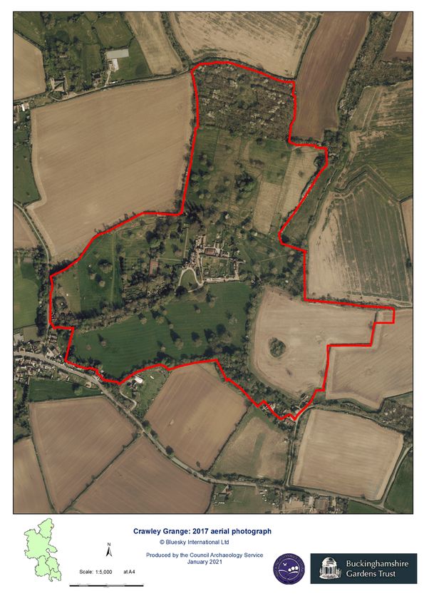
HISTORIC SITE BOUNDARY
1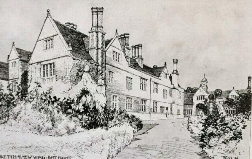
Bucks Gardens Trust, Site Dossier: Crawley Grange, MKDC   Consultation Dossier February 2021

                                             2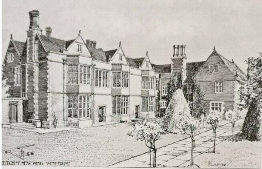
Bucks Gardens Trust, Site Dossier: Crawley Grange, MKDC   Consultation Dossier February 2021

INTRODUCTION

Background to the Project
This site dossier has been prepared as part of The Buckinghamshire Gardens Trust (BGT) Research
and Recording Project, begun in 2014. This site is one of several hundred designed landscapes
county‐wide identified by Bucks County Council in 1998 (including Milton Keynes District) as
potentially retaining evidence of historic interest, as part of the Historic Parks and Gardens Register
Review project carried out for English Heritage (now Historic England) (BCC Report No. 508). The list
is not definitive and further parks and gardens may be identified as research continues or further
information comes to light.

Content
BGT has taken the Register Review list as a sound basis from which to select sites for appraisal as
part of its Research and Recording Project for designed landscapes in the historic county of Bucks
(pre‐1974 boundaries). For each site a dossier is prepared by volunteers trained by BGT in appraising
designed landscapes.

Each dossier includes the following for the site:
       A site boundary mapped on the current Ordnance Survey to indicate the extent of the main
       part of the surviving designed landscape, also a current aerial photograph.
       A statement of historic significance based on the four Interests outlined in the National
       Planning Policy Framework and including an overview.
       A written description, derived from documentary research and a site visit, based on the
       format of Historic England Register of Parks & Gardens of special historic interest 2nd edn.
       A map showing principal views and features.

The area within the site boundary represents the significant coherent remains of the designed
landscape. It does not necessarily include all surviving elements of the historical landscape design,
which may be fragmented. It takes no account of current ownership.

NOTE: Sites are not open to the public unless advertised elsewhere.

Supporters and Acknowledgements
The project was funded by BGT, with significant grants from the Finnis Scott Foundation, the
Roland Callingham Foundation, BCC (since April 2020 part of Buckinghamshire Council) and
various private donors. Buckinghamshire Council also provided significant funding, and help in
kind including current and historic mapping and access to the Historic Environment Record. The
project is supported by The Gardens Trust.

The Trust thanks the volunteers and owners who have participated in this project and given so much
time and effort to complete this challenging and rewarding task.
Further information is available from: www.bucksgardenstrust.org.uk

                                                        3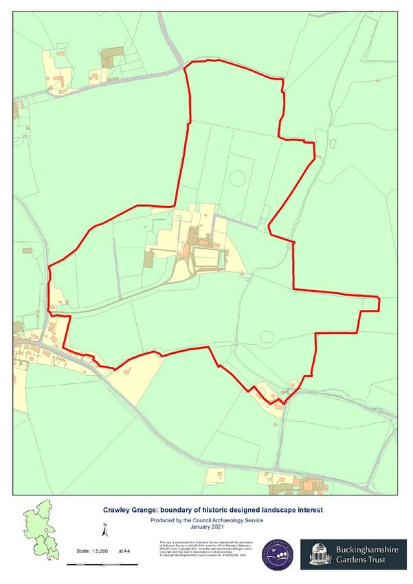
Bucks Gardens Trust, Site Dossier: Crawley Grange, MKDC   Consultation Dossier February 2021

SITE NAME: CRAWLEY GRANGE                                      MK HER NO: -

COUNTY: BUCKINGHAMSHIRE                                        GRID REF: SP 931 449
PARISH: NORTH CRAWLEY                                          POSTCODE: MK16 9HL

STATEMENT OF SIGNIFICANCE

Overview
The park, garden and pleasure grounds for a Tudor country house, developed in their present form
during the C19 and early C20, possibly incorporating elements of an earlier landscape associated
with the house. The garden combines formal and informal features and planting and was extended
into the park in the later C20. The park has a C19 serpentine approach avenue and together with the
garden retains many mature specimen trees and clumps. This is a good example of its type, which
survives largely intact along with the rural setting including the village.

Archaeological Interest
The site has the potential for evidence associated with agricultural and village uses, particularly
relating to banks, routes, boundaries, etc. The main drive follows the line of a former public road and
may incorporate evidence of that earlier feature. The site has potential for lost structures related to
the Tudor house and associated ornamental and working landscape which had been absorbed within
an agricultural fieldscape established in its present form by the early C19, after Inclosure in 1773;
also for former features of the designed landscape from the C19 onwards, e.g. buildings, paths,
beds, boundaries, the kitchen garden, and elements of the south-east approach, also following the
line of a former public road.

Architectural Interest
The layout is focussed on the country house at the heart of the park. It is a good example of Tudor
architecture with 1907 additions in similar style by architect Henry Tanner Jnr at the same time as he
designed the stable quadrangle and possibly garden structures on the east side of the walled garden.
His design for the wing was published in 1907. The two former Tudor-style arches flanking the
entrance front of the house, leading to the garden and stable yard respectively, and now reduced to
piers, were the main garden ornament by the early C20. Their origin is unclear but were perhaps by
Tanner too. Other structures are typical estate buildings including the two lodges, the kitchen
garden wall and sheds and the remains of a Messenger greenhouse outside the south wall.

Artistic Interest
The design is a typical country house estate largely established in the C19 with minor modifications
in the early C20. It comprises park, woodland, garden and pleasure grounds which reached its zenith
in the 1900s. The layout at that point remains largely intact, with gardens and pleasure grounds to
the west of the house and walled kitchen garden to the east, with many mature trees and a fine
serpentine avenue along the drive, taking in views of the park. The structures by Tanner c.1907
made a considerable contribution. The later C20 garden extension west and south into the park
complemented the existing layout, along with the ornamental layout in the kitchen garden replacing
the productive use including an ornamental pond and adjacent ornamented building. Residential
development north and east of the walled kitchen garden has not greatly harmed the key historic
ornamental character.

                                                        4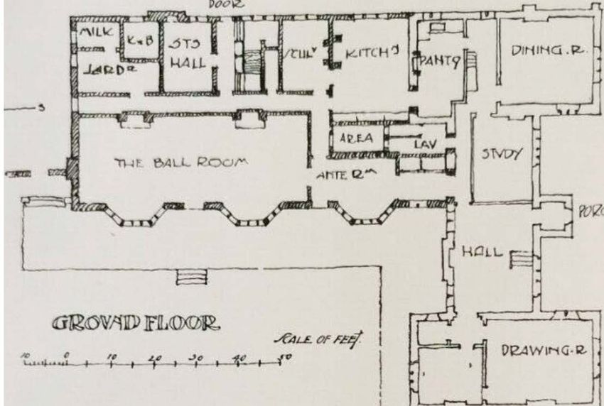
Bucks Gardens Trust, Site Dossier: Crawley Grange, MKDC   Consultation Dossier February 2021

Historic Interest
The site is of interest for its connection with local people of note, particularly Roger Hackett
(d.1621), the rector of North Crawley, whose fame as a preacher was widespread, and whose
descendants also owned the estate for some time.

HISTORIC DEVELOPMENT

The building was awarded to Cardinal Wolsey in 1526, only for him to be stripped of ownership
when Henry VIII confiscated Church possessions (Historic England). The property then went into
private ownership. Queen Elizabeth I may have visited the property in 1575 as the Royal Arms with
the Tudor Rose above and the Plantagenet portcullis below are carved on one of the oak window
shutters (Historic Monuments in Bucks). It was part of Mathias Manor.

In 1615 the property was bought by Roger Hackett (d.1621), the rector of North Crawley, whose
fame as a preacher was widespread. “Having bought in several farms and estates and laid them
together” he resolved to make it “his best and principal property”. His son Roger (fn. 116) settled his
mansion-house in Crawley on his son and heir Thomas at the marriage of the latter in 1650 with
Elizabeth daughter and heir of Augustine Nicholls, and died before 1658. Thomas Hackett died in
April 1689, and was succeeded by his son Nicholls, who had made a settlement of this property in
the previous year (VCH).

In 1723 William Lowndes held the property in trust for 99 years (VCH).

Before the Enclosure Award of 1773 the open field system predominated over the areas to the west
and south west of the village. Settlement in general was dispersed with a number of ends, typical of
a woodland settlement. The church and three farms were located at the centre together with many
smaller ‘home closes’ clustered around the village street. (Conservation Area Review, Oct. 2020)

Thomas David Boswell purchased the property in 1803 (Sheahan). Around this time the house stood
in an agricultural landscape of small fields (OSD, 1815). A road off Pound Lane from the village
passed the south front of the building. This was later used as the line of the main drive, presumably
when the present west lodge was built, before 1849 (Tithe Apportionment) when the Grange,
including lands, stabling, power-house and lodge with 15 acres was owned by John J. Boswell. Over
the porch entrance are the arms of Boswell and a Latin inscription, and carved into the overmantel
of the fireplace is a shield with the arms of the Boswell family (VCH).

By 1862 (Sheahan) the place was owned by a great-niece of Thomas Boswell, Mrs Williams. The
pleasure grounds were said to be, ‘well laid out, and planted with a choice collection of evergreen
and flowering shrubs.’ The lodge, presumably the west lodge at the present village entrance to the
main drive, was ‘in keeping with the style of the mansion’, i.e. Elizabethan.

By the 1880s (OS) the park and pleasure grounds had been laid out much as survives today. It is
unclear if this was all carried out in a single phase after 1815, or incrementally in several campaigns
(OSD).

In 1903 plans for alterations to the original Jacobean building were drawn up by Smith and Brewer,
architects. In 1907 the north-east wing was added by the architect, Henry Tanner Jnr (1876-1947)
who was a pupil to his father and then an assistant to Sir Aston Webb before he set up in practice in

                                                        5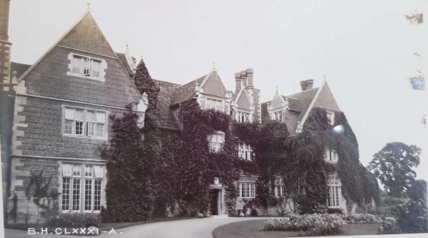
Bucks Gardens Trust, Site Dossier: Crawley Grange, MKDC   Consultation Dossier February 2021

1902 (DX 1336/4/2). At this time he was working on some significant projects in London including
the Bank of New Zealand and Hall Place, Surrey. His designs for the extension of Crawley Grange
were published in 1907 (Academy Architecture). The two drawings of the major elevations also show
the surrounding gardens including the east archway, his stable block and the kitchen garden wall. He
may also have been responsible for some features in the walled garden.

During WWII the property was requisitioned by the Ministry of Defence as a billet for WRNS working
at nearby Bletchley Park. After the war the property reverted to private ownership (VCH).

In the 1970s the Grange was split into 4 separate dwellings and the stable block was converted to
residential use. All remain in private ownership. The dwellings each have their own private garden,
as well as use of communal grounds, a hard tennis court and an outdoor heated swimming pool
(both recent additions).

SITE DESCRIPTION

Location, area, boundaries, landform and setting

The 35 ha. site lies about a quarter of a mile north-east of the Church of St Firmin, on the north-east
edge of the village of North Crawley in the far north-east corner of historic Bucks close to the border
with Bedfordshire to the east. North Crawley sits on a ridge in a rolling rural landscape and
agricultural land wraps around Crawley Grange. The house is nestled in a shallow valley surrounded
by rolling farm and parkland. The nearest town is Newport Pagnell which is 3 miles to the south-west
via North Crawley High Street. The village contains some fine old buildings. Mostly the buildings are
constructed from red brick with thatched or clay tiled roofs.

The site is bounded to the west by Pound Lane, a no-through-road leading out of the village into the
agricultural landscape, to the south by Crawley Road to Broad Green in Bedfordshire and to the
north and east by agricultural land. Four farms enclose the site: Dollars Grove, Filliol Manor,
Broadmead and Gumbrills Farm. The Chicheley Brook flows northwards through the east side of the
park and along the north end of the east boundary.

ENTRANCES AND APPROACHES

The main drive enters off Pound Lane, 350m south-west of the house. The entrance is marked by a
C19 single storey lodge on the north side, built in Tudorbethan style of red brick with stone dressings
under a clay tile roof, with a prominent central chimney stack. This west lodge was built by 1849
(Tithe Apportionment) and by 1862 it was noted as being ‘in keeping with the style of the mansion’
(Sheahan). From here the drive curves north-east through the park flanked by an avenue of mature
trees including lime, sycamore and oak set in grass. On nearing the house it opens into a large grassy
forecourt before arriving at the south, entrance front of the house, with views south over the park.
The drive apparently follows the line of the former public road present in 1815 (OSD) which ran close
to the south front of the house and then continued north-east parallel to the Chicheley Brook. By the
early C20 (historic images) the central panel in the forecourt was a mown lawn with scattered flower
beds and a shrubbery on the west side of the drive.

The surviving piers of two substantial arched gateways flank the south front of the house, giving
access from the forecourt to the garden, and to the stable block and service yards, to west and east
respectively. These were in Elizabethan/Jacobean style with ball finials as shown in a drawing based

                                                        6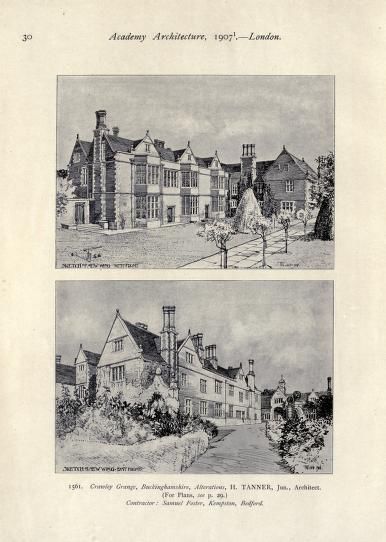
Bucks Gardens Trust, Site Dossier: Crawley Grange, MKDC   Consultation Dossier February 2021

on a photograph of 1912 (photograph Bucks Archive phNorth Crawley10 and Historic England
England’s Places; drawing in VCH) but the arches have gone, leaving the piers. It is unclear whether
these gateways were contemporary with the early phases of the house or were later additions.

A second route formerly approached from the south. The south lodge, in similar style to the west
lodge but built somewhat later, between 1881-99 (OS), marks the east side of the entrance off
Broadmead, 440m south-east of the house. From here the south-east route formerly curved north-
west through the park, initially alongside the west bank of the Chicheley Brook, reaching the grassy
forecourt 60m south-east of the house, and joining the south-west drive in front of the house (OS). It
now survives in part as a footpath.

These two routes are linked as they near the house by a spur off the south-west drive forming the
south side of the forecourt, overlooking the south park. This turns north to pass east of the east
gateway adjacent to the south front, flanked by the house and kitchen garden wall, leading to the
main entrance to the stable block and the former service yards. The north end is shown in 1907 in
the Tanner proposal drawing (Academy Architecture).

Adjacent to the south lodge a footpath enters the park on the east side of the Brook, meeting
several other footpaths at a footbridge 250m south-east of the house.

From a NE direction a footpath from Dollar’s Grove Farm to Pound Lane skirts along the edge of the
parkland on the NW side.

PRINCIPAL BUILDING

Crawley Grange (listed Grade II) stands towards the centre of the site, surrounded by gardens
including the walled kitchen garden adjacent to the east. It is a substantial C16 country house,
restored and extended in the early C20 and now divided into several residential units.

The plan for the original building was H shaped, with the wings at the east and west ends of the
central block and a projecting porch on the south front between the 2 wings; the north end of the
east wing was incorporated into the main building in 1907 in the extension designed by Henry
Tanner Jnr. This work was carried out by Samuel Foster builders of Kempston, Bedfordshire. Much of
the building is 2 storey with attic, however, the porch in its central position stands 3 storeys high
dominating the approach around the forecourt. The base is of dressed stone, brick with flush
bonded stone quoins, moulded stone strings over windows, stone capped gable ends on kneelers,
with ball finials on apex, old tile roof, with prominent ornamental chimneys with diagonal brick
shafts and offset heads. The entrance front is to the south, with the garden fronts to the west and
north-west, and the service yards and buildings to the east and north-east.

The conversion work to split the Grange into separate dwelling units was conducted in the 1970s.
The house enjoys views south over the forecourt, park and beyond, and east over the kitchen garden
from the upper levels of the house to rising agricultural land beyond the park. The west, garden
front overlooks the pleasure grounds.

Immediately north-east of the house are the former stables, hayloft, coach house and gun room
(listed Grade II) which have been converted into two houses. They were built c. 1907 by Henry
Tanner Jnr, the architect of the restoration and new north-east wing, and altered in the 1970s
alongside the house. The block comprises Jacobethan style buildings along 3 1/2 sides of a courtyard

                                                        7
Bucks Gardens Trust, Site Dossier: Crawley Grange, MKDC Consultation Dossier February 2021
in handmade red bricks in Flemish bond, with stone dressings and a tiled roof with a lead cupola.
Brick and stone stacks set diagonally complement those of the house.
The main south front is of one storey and attics. The central battered lead cupola has a gold clock
face of 1829 by Swaythes and Read. The central projecting gable has ball finials, a stone sundial and
a 4-light stone casement. The south range is dominated by a Tudor-style carriage arch entrance to
the yard beyond with battered pilasters with trefoil ornament with original wooden doors. The arch
dominates the approach along the service drive from the forecourt. On each side is a tall gabled
dormer with ball finials and mullioned window. Attached to the north-east is an L-shaped stable
range of one storey with louvred lead cupola, stone mullioned windows and 6 original wooden
doors. The fourth, west side of the courtyard adjacent to the garden is completed by a brick wall
with triangular coping and arched opening. This building is linked to the house by a similar wall with
a Tudor-style stone arch with wooden door between the south-west corner and the north end of the
east wing of the house.
Further residential buildings and gardens have been added in former service areas east of the stable
block in the C20, surrounding the kitchen garden to the north and east in part replacing former
service buildings including an Engine House on the north side (OS).
GARDENS AND PLEASURE GROUNDS
The gardens lie west and north of the house and are enclosed by the park. The north gardens,
present by the 1880s (OS), are laid to lawn with many mature ornamental specimen trees scattered
to the west and north, including some fine conifers. Garden doors lead from Tanner’s north wing of
the house, including from the former ball room, a lawn enclosed by stone-flagged paths, and a spinal
path running 80m north through further lawns to a modern swimming pool towards the north tip of
the garden. The lawns west of the path were extended westwards by 1900 (OS). The garden close to
the house is shown in 1907 in the Tanner proposal drawing (Academy Architecture), including the
stone-flagged path with standard roses alongside, the lawn and other planting including clipped
specimen shrubs, as well as a croquet set, suggesting it was used as a croquet lawn.
A path leads west from the house to the south-west gardens, which were added in the later C20
when the land was enclosed from the park. This area, measuring c.160m x 120m, is bounded to the
south by the drive. It is divided into several compartments including at the south-west corner a
formal hedged area laid out c.2008, a hard tennis court, and other compartments.
PARK
The park encloses the house and gardens. It was laid out in the mid-C19 and was complete by 1880
(OS). It is largely pasture with many mature scattered specimen trees and clumps, largely deciduous
but with some conifers. It is divided into four main sections: the north, north of the house and
pleasure grounds; the west, divided into north and south halves by the drive and avenue; and the
south-east corner, east of the Chicheley Brook which divides it from the west park. The south-east
corner is arable but retains a C19 roundel clump and a few specimen trees. North of this section the
Brook flows northwards marking the east boundary of the park.
8Bucks Gardens Trust, Site Dossier: Crawley Grange, MKDC Consultation Dossier February 2021
KITCHEN GARDEN
The 0.35 ha. rectangular kitchen garden, c.80m x 50m, lies east of the house divided from it by the
service drive to the stables. It is bounded largely by red brick walls divided into panels by brick piers
with stone coping and caps, but the east wall has gone. A gateway in the west wall gives access from
the east wing of the house with stone steps down. A stone doorway in the north wall gives access
from the former yards. Outside, against the south wall is a range of sheds and the remains of a
Messenger and Co greenhouse. Beyond to the north and east include late C21/C21 houses and
gardens on the site of former service buildings.
The formerly productive area is now residential gardens largely laid out with lawns and a central
path lined with a low clipped box hedge running west to east. A modern formal geometric layout
occupies the south-west corner.
A rectangular ornamental pond occupies the east edge, overlooked by a two-storey brick tower with
a tiled pyramidal roof set into the north-east corner of the garden and a timber barn adjacent to the
east. The pond, tower and barn were built in the early C20 (OS, 1899, 1924) and were perhaps part
of the work when Henry Tanner Jnr. worked on the house and built the stables in c.1907. The west
wall and a gateway are shown in Tanner’s drawing of 1907 (Academy Architecture) with the Tudor-
style arch and his new wing and stables beyond.
REFERENCES
Books and articles
Academy Architecture & Architectural Review (1907), 28-31. (Proposals by Tanner for extension, see
below)
Milton Keynes Council, Conservation Area Review (Draft Oct. 2020).
https://www.milton-keynes.gov.uk/assets/attach/67785/North-Crawley-CA-Review-
consultation1.pdf
Page, William (Ed), A History of the County of Buckingham: Volume 4 (1927), 327-338. (VCH)
in British History Online http://www.british-history.ac.uk/vch/bucks/vol4/pp327-338 [accessed 18
January 2021]
Pevsner, N, and Williamson, E, The Buildings of England: Buckinghamshire (2nd edition 1994)
Sheahan, J., History and Topography of Buckinghamshire (1862), 525-26.
"North Crawley," An Inventory of the Historical Monuments in Buckinghamshire, Vol. 2 (1913), 219-
23. in British History Online, accessed January 21, 2021, http://www.british-
history.ac.uk/rchme/bucks/vol2/pp219-223.
Maps
Jeffreys Map of Bucks (1768)
Bryant, Map of Bucks (1825)
OS Surveyor’s Drawing (1818)
OS 25” to 1 mile, surveyed 1880
OS 25” to 1 mile, revised 1898
OS 25” to 1 mile, revised 1924
9Bucks Gardens Trust, Site Dossier: Crawley Grange, MKDC Consultation Dossier February 2021
OS 25” to 1 mile, revised 1938
OS 6” to 1 mile, surveyed 1881
Illustrations
Engraving in VCH from photograph c.1912. (See below)
Archival Items
Buckinghamshire Archives
North Crawley Inclosure Award, D-X120/2 (11 June 1773)
North Crawley Inclosure Award, 1773, IR/33
North Crawley Inclosure Award, 1773, Office copy D-X2/25/1
North Crawley Tithe Apportionment (?1849)
PE, KJ, SR January 2021 Edited SR February 2021
10Bucks Gardens Trust, Site Dossier: Crawley Grange, MKDC Consultation Dossier February 2021
KEY HISTORIC FEATURES
11
4
3
1
10
12 5 2
7
9
6 12
12
9
8
11Bucks Gardens Trust, Site Dossier: Crawley Grange, MKDC Consultation Dossier February 2021
Key to numbered features
1. House 2. Forecourt
3. Stable block 4. North lawns (C19)
5. South and west lawns (C20) 6. West Lodge and village entrance
7. Main drive 8. South lodge and former Broadmead entrance
9. Former south approach 10. Kitchen garden (former)
11. North Park 12. South Park
HISTORIC IMAGES
Postcard, south front and forecourt. c.1912.
12Bucks Gardens Trust, Site Dossier: Crawley Grange, MKDC Consultation Dossier February 2021
Sketch of south front and forecourt. c.1912, Lawrence Davies, based on photograph above, in
Victoria County History
Photograph of south front and forecourt, early-mid-C20.
13Bucks Gardens Trust, Site Dossier: Crawley Grange, MKDC Consultation Dossier February 2021
Academy Architecture & Architectural Review (1907) Tanner proposals for extension.
Enlargements
14Bucks Gardens Trust, Site Dossier: Crawley Grange, MKDC Consultation Dossier February 2021
15You can also read