CURRICULUM ROSA LASAPONARA - Cnr
←
→
Page content transcription
If your browser does not render page correctly, please read the page content below
ROSA LASAPONARA
 CURRICULUM

                  1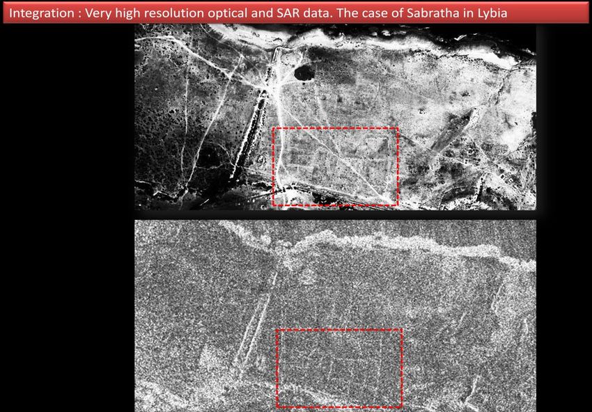
GENERAL DATA, TITLES, SCIENTIFIC AND RESEARCH MANAGEMENT CAREER       3

RESEARCH ACTIVITY : BRIEFLY                                           4

SCIENTIFIC RESEARCH ACTIVITY                                          6

INTERNATIONAL COMMITMENT                                              8

INTERNATIONAL CONFERENCE    ORGANIZATION AS CHAIR OR CONVENER         10

SELECTED PROJECTS CURRENT RUNNING (LIST)                              10

LIST OF SELECTED PAST PROJECTS                                        11

LIST OF SELECTED RECENT AWARDS                                        12

PROJECTS FOCUSED ON   UNESCO WORLD HERITAGE SITES                     15

EDUCATIONAL AND DISSEMINATION ACTIVITIES IN COOPERATION WITH UNESCO   27

CONFERENCES, SCIENTIFIC COMMITTEE, EDITORIAL BOARD                    27

PUBLICATIONS                                                          33

TEACHING ACTIVITY                                                     48

                                                                           2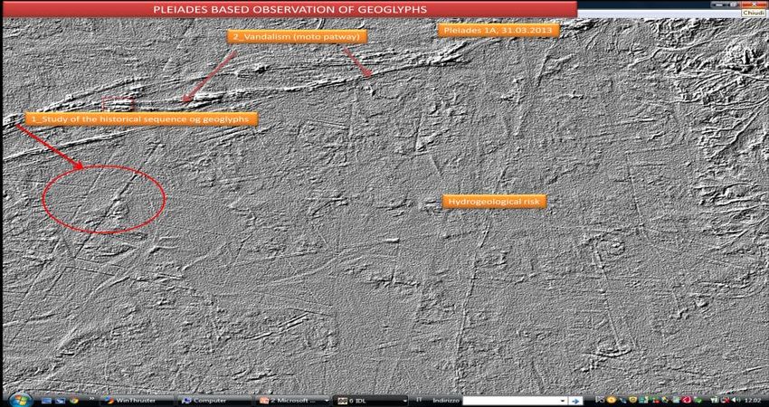
A) GENERAL DATA, TITLES, SCIENTIFIC AND RESEARCH MANAGEMENT CAREER
Name: ROSA
Surname : LASAPONARA
Date of birth: 8 LUGLIO 1965
Place of birth: IRSINA (MT)
Address: c.so Umberto I, 32 – 85100 POTENZA – ITALIA.
E_mail mrosa.lasaponara@imaa.cnr.it; rosa.lasaponara.cnr.it
Tel: 328/6271131 (cell), ++39 0971/427214 (CNR), ++39 340/9031154
Foreign languages: ENGLISH
A.2 ACTUAL POSITION
Researcher of CNR- at the IMAA
Chief of the ARGON Laboratory (Earth Observation for ARchaeoloGy and EnvirONment
of the CNR-IMAA in Tito Scalo (Potenza).
Manager of a CNR Research Commitment “Integrated Earth Observation technologies for
archaeology and landscape archaeology since 2007 (PC.P01.001.003)
Manager of a CNR Research Commitment “"Palaeoenvironmental transformations induced
by human activities using remote and in situ data analysis” (RSTL.055.010) since 2007
Manager of a CNR Research Commitment “"Remote sensing based monitoring of natural
and human induced risks for Cultural heritage since2011
Adjunct Professor of Microwave in the Faculty of Architecture of University of Basilicata –
Potenza (since 2010)
Visiting Professor at the CONAE (Argentina).
Italian Scientific responsible of Great Relevance Project Italy-Argentina “Smart
management of cultural heritage sites in Italy and Argentina: Earth Observation and pilot
projects” – Argentine partner: CONAE
President of MEOGEO Spin off CNR
A.3 SCIENTIFIC CAREER : BRIEF CHRONOLOGY
1993: Degree in Electronic Engineering.
1993-94: MS in Environmental Engineering
1995-1998: PhD in Remote Sensing
2001: Researcher at CNR-IMAA.
2010: Professor of Microwave in the Faculty of Engineering of the University of Basilicata.
3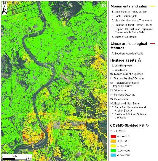
A.4 RESEARCH MANAGEMENT : BRIEF CHRONOLOGY
2006: Manager of a CNR Research Commitment: “ Remote sensing based monitoring of
natural and human induced risks for Cultural heritage since” (at the Dipartimento of
Patrimonio Culturale
2007: chair of the EARSeL (European Association Remote Sensing Laboratories) Special
Interest Group (SIG)- on "Remote Sensing for Archaeology, Natural and Cultural Heritage".
2007 : President of MEOGEO spin-off of CNR
2009. Chief of ARGON Laboratory (Earth Observation for ARchaeoloGy and
EnvirONment
A.5 RESEARCH ACTIVITY : BRIEFLY
Director of International Mission ITACA-Peru
Scientific responsible and project manager of n. 31 national and international research
projects and investigation campaigns (2001-2014).
She authored and co-authored more than 250 publications, including papers on international
journals, Books, one patent, book chapters, 9 special issues of international journals
She has been general chair of an international conference (EARSEL Symposium 2013),
several workshops (EARSEL Workshop of remote sensing for Cultural heritage: Rome
2008; Matera 2013; workshops for ICCSA conference: Santander 2011; Salvador de bahia
2012; Ho Chi Minh 2013), convener of several scientific sessions (EGU2007, 2008, 2009,
2010, 2011, 2012, 2013; SPIE 2007-09), and member of scientific committees of
international conferences and workshops (SPIE 2007- 2014; EARSEL 2008, 2013; ICCSA
2011-2014)
She is associate Editor and/or component of the Editorial Board of the following journals:
NHESS
Journal of Remote Sensing & GIS
Journal of Geophysics and Engineering
Remote Sensing
Remote sensing of Environment
IEEE
Ecological Modelling
American Journal of Engineering and Applied Sciences
Studies in Surveying and Mapping Sciences
Open Journal of Remote Sensing and Positioning
Archaeology
She is/has been Guest Editor of special issues of international journals : Journal of Cultural
Heritage (2009, vol. 10S), Ecological Modelling (2010, vol. 221; 9), International Journal
of remote Sensing (2010, vol.33(15) , Journal of Archaeological Science (2011, vol. 38),
Archaeological Prospection (2013, vol. 20), International Journal of Applied Earth
Observation and Geoinformation (2013, vol. 20), International Journal of Applied Earth
Observation and Geoinformation (2014, vol. 26)
4
Special issue coordinated as guest editor
      Lasaponara et al. 2014 Advances in geoscince International Journal of Applied Erath Observation
      and Geoinformation vol 26
      Lasaponara R and Masini Special Issue on “ Satellite Synthetic Aperture Radar in Archaeology and
      Cultural Landscape: An Overview. Archeological Prospection (pages 71–78)
       Lasaponara R.,. 2013 Special Issue on “Earth Observation and geoinformation for environmental
      monitoring” International Journal of Applied Erath Observation and Geoinformation vol 20
      Lasaponara R.,. Lanorte A. 2012, Special Issue on “Satellite time series Analaysis :from local
      analysis to a global view” International Journal of remote sensing, vol 33
      Lasaponara R., Masini N. 2011, Special Issue on “Satellite remote sensing in archaeology: past,
      present and future perspectives”, Journal of Archaeological Science, vol. 38.
      Lasaponara R., Masini N. 2009, Special Issue on “Remote Sensing for Cultural Heritage
      Management and Documentation”, Journal of Cultural Heritage, vol. 10S.
      Lasaponara R., Hernandez M., Masini N., Deroin J.-P., 2010. Special Issue on “Aerial and Spatial
      Archaeology: from Historical Photographs to Lidar”. Photo Interpretation European Journal of
      Applied Remote Sensing, vol. 46.
      Lasaponara R., 2010, Special Issue on Spatial and temporal Pattern of wildfire: Models, Theory and
      reality Ecological Modelling vol 221
      Lasaponara R., Ciminale, S. Piro 2009 Special issue “Integrated Remote Sensing techniques for
      Archaeological Prospection” Journal of Archaeological Prospection vol 26 issue 3

A7 H-INDEX AND CITATIONS

SCOPUS: H-index=15, Citations=261

Google Scholar: H-index=21, Citations=725
(http://scholar.google.it/citations?user=ZcLVMlcAAAAJ&hl=it)

                                                                                                      5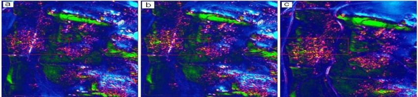
6
B) SCIENTIFIC RESEARCH ACTIVITY

                                  7
B) SCIENTIFIC RESEARCH ACTIVITY
B.1 RESEARCH INTEREST
My dominant scientific interest, throughout my career, has been the application and the
development of methodologies for the operative use of remote sensing technologies for natural and
cultural heritage preservation and management set up and currently.
I set up and currently chair the special interest group " Remote Sensing for natural and cultural
heritage" of the European Association of Remote Sensing Laboratories (EARSeL) in cooperation
with and supported by UNESCO.
My dominant scientific interests deal with the operative use of EO techniques mainly in the fields
of: (i) environment and risk monitoring, (ii) interactions between humans and environment systems;
iii) Anthropology, land use practices and their effects on ecosystems; (iv) innovative active and
passive remote-sensed technology (LIDAR, multi-and hyper-spectral high resolution) for landscape
prospection and Historical and archaeological landscape.
I set up and currently lead the ARGON Laboratory (Earth Observation for ARchaeoloGy and
EnvirONment) of the CNR at IMAA in Tito Scalo (Potenza).
The research activity of the ARGON laboratory, in the international context delineated by
HORIZON 2020, is mainly directed to the study of the biosphere using remote sensing techniques
and in situ analysis. The specific objectives are the development of algorithms and methodologies
concerning the extraction of information from historical data series collected by active and passive
sensors (airborne and satellite platforms) for the characterization of phenomena and processes with
particular reference to the identification of changes (on various spatial and temporal scales) and the
operational monitoring of land degradation, natural and anthropic risks.
Main activities:
8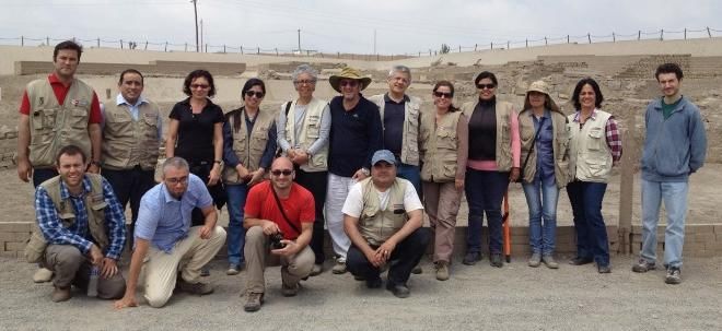
A) Time series analysis and development of algorithms for change detection for operational

monitoring of land degradation and natural and anthropic risks:

       Land degradation

       Urban sprawl

       Desertification monitoring

       Fire monitoring: (i) estimation of hazard / risk by fire, (ii) characterization of the system of

       rings, (iii) integrated systems for fire detection, (iv) perimeter of the areas covered by the

       fire, (v) monitoring of recovery Snow vegetation, (vi) estimates of resilience to fire through

       the use of time-series satellite and ancillary data, (vii) the characterization and modeling of

       vegetation for estimating the biomass consumption, emissions, fire behaviour

       Monitoring of fire impact on hydro geological risk and mitigation strategies

B) Development of algorithms for data fusion, edge detection, and pattern recognition for

archaeological and palaeo-environmental studies for investigating the dynamics of anthropogenic

environmental

     Identification and characterization of buried structures of archaeological interest

     reconstruction of palaeo-environmental scenarios aimed at understanding the mutual

     relationships between the dynamics of environmental change and evolutionary processes of

     human presence;

   B) C) Satellite time series analysis for investigating
           a. interactions between humans and environment systems;
           b.   Anthropology: mainly land use practices and their effects on ecosystems;

                                                                                                     9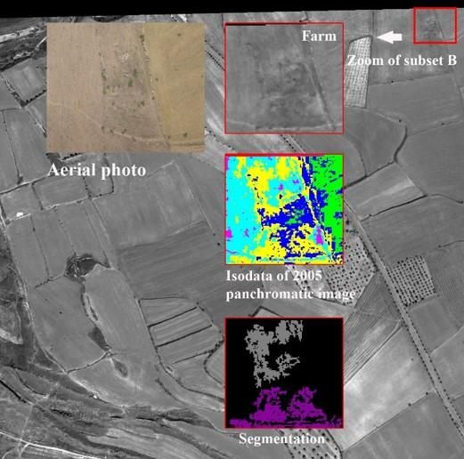
c. innovative methods for remote sensed multi-and hyper-spectral high resolution data
analysis for archaeological prospection. and palaeaoenvironmental reconstruction
d. Historical risk
I have pursued this major interest through several lines of enquiry
1) GIS and Remote Sensing for Archaeology and Cultural Heritage Management by means of :
the development and use of data processing algorithms of very high resolution satellite
imagery for the detection of buried archaeological sites and palaeonvironmental features;
the application of LiDAR for investigating potential archaeological areas covered by
vegetation;
Post processing of high resolution digital models for the interpretation of microrelief of
archaeological interest
the use of local spatial autocorrelation statistics of satellite data for Very high resolution
satellite imagery for the monitoring and the assessment of man-made risks of archaeological
heritage
Integration of geophysics with airborne and spaceborne remote sensing for
archaeogeophysical investigations
SAR data processing for archaeological applications
B.2 INTERNATIONAL COMMITMENT
(10/2008-present ) Photointerpretation
3. Editor (06/2009-present) of EARSeL NewsLetter
4. EARSeL Tresour (06/2010-present)
5. Member (06/2010-present) of EARSeL Bureau
6. Supporting Scientific Secretary (05/2010-present) Fire EGU Natural Hazard Division
7. SPIE Program committee ( 2007 -present)
8. ICCSA Program committee ( 2008 -present)
10 9. EARSeL Symposium Program committee ( 2008 -present)
10. Convener of Spatial and Temporal patterns of Forest Fire at EGU Assembly Session
(2008 to present)
11. Convener of satellite time series analysis at EGU Assembly Session (2008 to 2012)
12 Chairman of EARSeL SIG-RESEARCH Remote Sensing and Information Technologies
for archaeological investigation, protection and valorization of Cultural Heritage ( 2007 -
present)
13. Chairman (2008, 2011, 2012) of the I, II, III EARSeL workshop "Remote sensing for
Archaeology"
14 Chairman (2009) of the VII EARSeL workshop " Remote sensing for forest fire"
15. International external evaluator PhD committee at committee at the following
University: UCL- London Alcala- Spain, Ghent-Belgium, Salonicco- Greece, Pisa-Italy,
Bariloche-Argentina
16. Visiting professor at the University of Comahue Argentina
17. Visiting professor at the University of S Luis Argentina Since 2007
Investigation campaigns.
April 2007: aerial prospection of Rio Nasca;
April 2008: Cahuachi, georadar prospections in Templo Escalonado;
November 2008: Cahuachi, geomagnetic prospections in Piramide Naranjada, infrared
surveys, Ground truth of archaeological features detected from satellite imagery in Rio
Nasca,
January 2009: field surveys in Ventarron
May 2009: Tiwanaku, Geomagnetic prospections, GPS surveys, Ground truth of
archaeological features detected from satellite imagery
August 2009. Cahuachi: Geomagnetic prospections in templo Escalonado and in Rio Nasca,
measurement of seismic noise, Ground truth of archaeological features detected from
satellite imagery, drawing of samples of adobe to be analyzed
August 2010. Cahuachi, Geoelectric prospections, measurement of seismic noise in
Piramide Naranjada, GPS survey in the area of geoglyphs at South of Cahuachi.
December 2010. Arenal and Ucupe (Lambayeque). Archaeogeophysical investigations
11 April 2011. Titicaca Lake, field survey for the study of waru-waru and the fortress of
Pukarrani.
August-September: archaeogeophysical investigations in Huantar (Ancash) and Cahuachi
(Nazca); field survey for the study of ancient aqueducts in the drainage basin of Nazca river
November-December: archaeogeophysical investigations in Arenal, Collud and Zarpan
(Lambayeque region)
December 2012: archaeogeophysical investigations in Cahuachi, Pachacamac
November-December 2013: archaeogeophysical investigations and field survey in
Pachacamac, Cahuachi and Rio Taruga, near Nazca.
June 2014. Tiwanaku (Bolivia) Archaeogeophysical investigations and surveys Akapana,
Kantatallita and Templete.
Highlights and discoveries.
2008-09: Discovery of a buried pyramid near Rio Nasca by means of satellite remote
sensing and geomagnetic investigations
2009. Cahuachi : discovery of an altar, a ritual offering in Piramide Naranjada and the tomb
of the Priestness Girl.
2011. Arenal (Lambayeque): discovery of a Moche temple (III-IV cent. A.D.)
2011-12, Cahuachi: geophysical support to the discovery and the excavation of Piramide Sur
2013, Satellite map of ancient aqueducts in the Rio Nazca drainage basin
International Conference :
organization 2014-2008
Selected events 1. SPIE Program committee ( 2007 -present)
2. ICCSA Program committee ( 2007 -present)
3. EARSeL Symposium Program committee ( 2008 -present)
4. Convener of Spatial and Temporal patterns of Forest Fire at
EGU Assembly Session (2008, 2009, 2010)
5. Convener of satellite time series analysis at EGU Assembly Session
(2008, 2009, 2010, 2011,2012, 2013, 2014)
6. Chairman (2008, 2011,2012,2013) of the EARSeL Conference
12"Remote sensing for Archaeology"
7. Chairman of the 33 EARSeL Symposium and accompanying events
Matera June 2013
8. Chairman (2009) of the VII EARSeL workshop " Remote
sensing for forest fire
Selected Projects Current running
- Scientific responsible for CNR- of the EU of "ArchaeoLandscapes
Europe" (ArcLand)
http://www.archaeolandscapes.eu/index.php/en/about/aims.html
- FP7 Beyond Building Capacity for a Centre of Excellence for EO-based
monitoring of Natural DisasterFP7-REGPOT-2012-2013-1
- CNR-IMAA PI of Smart management of cultural heritage sites in Italy
and China: Earth Observation and pilot projects funded by the MInistero
degli Affari Esteri --MAE PGR00570 2012-2015
- PI of Earth Observation Technologies for the survey, investigation and
valorisation of Ancient Aqueduct systems in Peru International funded in
the framework of the Cooperation CNR-CONCYTEC 2012-2014 n.
0031559
- PI of FIRE-SAT an integrated model to monitoring in real time of forest
FIRE Funded Protezione Civile in the framework of operational
monitoring of risk by 2013-2014
- Partecipation to ESA Project “Assessing Satellite SAR data for
Landscape and archaeology” Id. 11073
- Partecipation in the Project ““Smart Cities and Communities and Social
Innovation” (Avviso MIUR n.84/Ric 2012, PON 2007 – 2013 del 2
marzo 2012) Misura IV.1, IV.2,. 2013- 2015
- PI of Remote Sensing technologies for Natural and Cultural heritage
Degradation Monitoring for preservation and valorization (MITRA)
2012-2014
- Partecipation in the Project “ World Heritage monitoring by Remote
Sensing (WHERE)” funded by ASI 2012-2013 (external consultant)
- Partecipation in the Project “Soil Slow MoTion Monitoring by
interferometry” (SoS-MT-Monitoring) funded by ASI 2012-2013
- PI of the project “From LiDAR survey to virtual reconstruction”
Basilicata Innovazione 2013-2014 FESR action
- PI of the project “Low cost technologies for fire monitoring: from the
performance assessment to the availability of operative tools” funded by
Basilicata Innovazione 2012-2013 FESR action
Selected Past Projects
Selected Past Projects
- PI of FIRE-SAT an integrated model to real time monitoring of forest
FIRE Funded Protezione Civile in the framework of operational
monitoring of risk using Earth Observation Technologies by 2010- 2012
13- Scientific responsible for the CNR_IMAA activities of the FUELMAP”
Development of a European fuel map” Contract notice n 2008/S 116-
153998 del 17/06/06 Tender funded by Joint Research Centre- Institute
for Environment and Sustainability (JRC- IES) ISPRA (Italia)
- PI “Fuel model, mapping and real time fire monitoring " Funded by
Protezione Civile 2007/2009
- PI of FIRE-SAT an integrated model to real time monitoring of forest
FIRE Funded Protezione Civile in the framework of operational
monitoring of risk using Earth Observation Technologies by 2008- 2010
- PI “Investigating of Landscape transformation and the impact of Human
activities integrating Earth Observation and ancillary data sources”
DG.RSTL.055.010 funded by CNR 2005-2010
- Scientific responsible for the CNR_IMAA activities of the “Preview
Winter Fire FP6 project : framework of EURORISK/PREVIEW
“Prevention, Information and Early Warning pre-operational services to
support the management of risks VI FP- Integrated project
- Scientific responsible for the CNR_IMAA activities of the CYBER-
PARK FESR 2000 –Pilot project for the management of natural
Protected areas” funded by the Puglia Region
- Scientific responsible for the CNR-IMAA activities of the PROSCENIO
funded by Protezione Civile Nazionale 2005-2007
- PI of Fire susceptibility estimation in the Mediterranean ecosystems by
using AATSR, MODIS, VEGETATION, and AVHRR data” n 1503
ESA (European Space Agency)
- Participation to the programme “Development of industrial districts for
the Earth Observation” (Programma PON 2000-2006, MIUR).
- Participation in the Project “Development and improvement of the CNR-
IMAA Earth Observation Facility” (Programma PON 2000-2006
PC.P01.001)
- Participation in the Project BioItaly and Natura 2000 for the Puglia
Region1994-1996
.
Selected recent Awards
141. Leadership Awards from ICSSA July 2014
2. Leadership Awards from EARSEL June 2014
3. Awards BEST Innovation for 2014 year from Focus May 2014
(http://www.imaa.cnr.it/index.php?option=com_content&view=article&id=359:
comunicato-stampa-premio-innovazione-
2014&catid=63&lang=it&Itemid=146)
4. Best paper Awards June 1999 CNR- highlights CNR 2008/2009 (
http://www.cnr.it/documenti/Highlights2008_2009.pdf)
5. Awards for Renewed expert in the field of remote sensing for archaeology
from belspo 2009
6. Discovery of a buried archaeological settlement near Nazca river in Peru
(2008
7. Awards for Innovation 2014 year in the field of Environmental monitoring
FIRESAT 2014 from Focus May 2014 (http://www.cnrweb.tv/firesat-
linnovazione-giusta-per-il-nostro-pianeta/)
8. Best paper Awards RSCy 2013 (First International Conference on Remote
Sensing and Geoinformation of Environment
9. Paper of special interest “Multitemporal analysis and archaeogeophysical
methods to monitor and face the archaeological looting: the experience in
Nasca (Southern, Peru)” presented in the session “Satellite time series
analysis”, EGU Assembly Wien 4 apr. 2011.
10. Paper of special interest “Archaeogeophysics in Peru and in Bolivia: the
contribution of Italian CNR with ITACA mission (2007-10).” showed in the
session “From artefact to historical site : geoscience and non invasive
methods for the study and conservation of cultural heritage”, EGU Assembly
Wien 5 apr. 2011
11. CNR- highlights CNR 2008/2009
12. Rotary Award “Outstanding Researchers”, assigned by Rotary Foundation
15Scientific and professional activity selected from the international and
national projects focused on UNESCO World heritage sites
Highlight
16Scientific cooperation activity with HIST and UNESCO and research activities
in Chinese UNESCO sites
Scientific and professional activity in the field of cultural heritage in
UNESCO sites : Argentina
Scientific and professional activity in the field of cultural heritage in
UNESCO sites: Peru
Scientific and professional activity in the field of cultural heritage in
UNESCO sites: Bolivia
Scientific and professional activity in the field of cultural heritage in
UNESCO sites : Turkey
Scientific and professional activity in the field of cultural heritage in
UNESCO sites : Africa
Scientific and professional activity in the field of cultural heritage in
UNESCO sites: Italy
Educational and dissemination activities in cooperation with
UNESCO
17Scientific cooperation activity with HIST and UNESCO and research activities
in Chinese UNESCO sites
Scientific responsible for CNR-IMAA of Memorandum of Understanding between CNR-IBAM,
CNR-IMAA, HIST and CAS- Center for Earth Observation and Digital Earth (prot. N. 3637,
26.09.2012)
Invited by Deputy Director (Tianhua Hong ) to have a one day seminar on 30 November 2012 at
Visited the Center for Earth Observation and Digital Earth and to visit HIST, (http://www.unesco-
hist.org/en-us/news/242.html)
She is co-responsible of the Great relevance project Italy-China funded by MAE titled “Smart
management of cultural heritage sites in Italy and China: Earth Observation and pilot projects”.
Chinese partners: HIST and CAS- Center for Earth Observation and Digital Earth (2013-159
Invited by Deputy Director (Tianhua Hong ) of HIST from 9 to 16 october 2013 to visit HIST, to
attend a bilateral meeting and field campaign in Luoyang (http://www.unesco-hist.org/en-
us/news/351.html)
Invited by HIST to attend Conference co-organized by UNESCO and HIST “Huangshan Dialogue
on Space Technologies for World Heritages sites, Biosphere Reserves, potential Geoparks” (26 to
30 May 2014) . Invited presentation entitled: “Space technologies and ICT for Cultural heritage
from the Chinese and the Italian perspectives” (http://www.unesco-hist.org/en-
us/resources/HuangshanDialogue/681.html)
Invited by Deputy Director (Tianhua Hong ) of HIST from 15 to 26 october 2014 to attend a
bilateral meeting and field campaign in Luoyang, Longmen and Hongcun already investigated
using satellite data
18Longmen (China)
- Investigations
October 2013: Survey and 3d modelling of Lomgmen
Buddhas (Scientific team: F. Gabellone, M. Chiffi, R.
Lasaponara, N. Masini)
HongCun (China).- Investigations
November 2013: Survey and 3d modelling of HongCun and jts surrounding”.
(Scientific team: G. Bitelli, Fulong Chen, R. Lasaponara, N. Masini)
19Scientific and professional activity in the field of cultural heritage in
UNESCO sites : Argentina
Argentina
She is responsible of the Great relevance project Italy-Argentina funded by MAE titled Argentina:
Earth Observation and pilot projects funded by the MInistero degli Affari Esteri --MAE,
17/04/2014, Prot. nr. 0090692, 2014-2016;
Project rationale : Cultural heritage management and preservation is a strategic priority to assure
cultural treasure and evidences of the human past to future generations but, at the same time, it also
represents a strategic and valuable economic asset, if inspired to sustainable development strategies.
This is an extremely important key factor for Argentina and Italy countries which are owners of an
extraordinary natural and cultural legacy, which is today particular fragile due to many reasons
including industrial risk, pollution impacts and degradation factors
Research activities focused on:
(i) Iguazù (UNESCO) Investigations : Monitoring human pressure using satellite and in situ
data for monitoring of compliance with the requirements imposed by UNESCO in the field of
protection and preservation of natural and cultural heritage for a sustainable use of them
(ii ) Cueva de las Manos, Río Pinturas – UNESCO-: Investigations addressed to
improve knowledge on the relationships between climatic change during Olocene and
human frequentation and landscape transformation
(iii) La Payunia e Campos Volcanicos Liancanelo e Payun Matru (Dipartimento di
Malargue, Mendoza ) in the UNESCO nomination list. Investigations addressed to
Support local authority in the production and arrangement of formal documentation
for the UNESCO candidacy
20Scientific and professional activity in the field of cultural heritage in
UNESCO sites : Peru
Peru NAZCA Lines
.- Scientific mission
Since 2008 : she has participated to the ITACA-PERU mission. Most of the investigations related
to the use of archaeogeophysical and remote sensing technologies have been varied out in the
region of Nazca (Cahuachi, Nazca lines and puquios)
B2.2 Investigation campaigns in Nazca
April 2007, April 2008, November 2008; August 2009; August 2010; September 2011; December 2012;
December 2013.
B2.3 she has participated to the Projects financed by Italian of Ministry of Foreign Affairs (2010,
2011, 2012, 2013, 2014)
B2.4 Other Projects:
ESA-Cat1: Archaeological and environmental studies in the Nasca region using C- and L-band
SAR imagery [2012-2014] P.I.: Francesca Cigna. Co-investigators: Rosa Lasaponara, Nicola
Masini, Deodato Tapete,
B2.5 Highlights and discoveries in Nazca region
2008-09: Discovery of a buried pyramid near Rio Nasca by means of satellite remote sensing and
geomagnetic investigations
2009. Cahuachi : discovery of an altar, a ritual offering in Piramide Naranjada and the tomb of the Priestness
Girl.
2011-12, Cahuachi: geophysical support to the discovery and the excavation of Piramide Sur
2013, Satellite map of ancient aqueducts in the Rio Nazca drainage basin
B2.6 Publications
Cigna F., Tapete D., Lasaponara R., Masini N., Amplitude change detection with ENVISAT ASAR to
image the cultural landscape of the Nasca region, Peru¸ Archaeological Prospection, 20, 117-131, doi:
10.1002/arp.1451
Tapete D., Cigna F., Masini N., Lasaponara R., Prospection and monitoring of the archaeological heritage
of Nasca, Peru, with ENVISAT ASAR, Archaeological Prospection, 20, 133-147, doi: 10.1002/arp.1449
Masini N., Lasaponara R., Lancho Rojas J. 2011. On the contribution of satellite data for archaeological
research in the Nazca Basin: spanning from site discovery and documentation to palaeo-environmental
investigations, Thule. Rivista italiana di studi americanistici, vol. 30/31, pp. 81-118.
R. Lasaponara, N.Masini 2009, La piramide di Cahuachi. Nell’area desertica di Rio Nazca una prospezione
archeologica da satellite riporta alla luce un grande complesso cerimoniale realizzato in terra cruda, Darwin,
29 (2009), gennaio-febbraio, pp. 46-51
Lasaponara R., Masini N. 2012. Following the Ancient Nasca Puquios from Space, In: Lasaponara R.,
Masini N. (Eds) 2012, Satellite Remote Sensing: a new tool for Archaeology, Springer, Verlag Berlin
Heidelberg, ISBN 978-90-481-8800-0, pp. 269-290
Rizzo E., Masini N., Lasaponara R., Orefici G. 2010, ArchaeoGeophysical methods in the Templo del
Escalonado (Cahuachi, Nasca, Perù), Near Surface Geophysics 8, 433-439, doi:10.3997/1873-0604.2010030.
21Masini N., Rizzo E., Lasaponara R. 2009. Teledeteccion y Investigaciones geofísicas en Cahuachi :
primeros resultados, in AA.VV., Nasca. El Desierto de los Dioses de Cahuachi, Graph Ediciones, Lima,
pp.250-277 [ISBN-10: 6124535920 ISBN-13: 9786124535925]
Awards
Wien, 3-8 April 2011. EGU Assembly - Paper of special interest “Multitemporal analysis and
archaeogeophysical methods to monitor and face the archaeological looting: the experience in
Nasca (Southern, Peru)” presented in the session “Satellite time series analysis”, Wien 4 apr. 2011.
Archaeological Complex of Pachacamac (Peru)
3.1.- Investigations
2012: Scientific responsible of archaeogeophysical
investigations for the study of the ancient water management
system
2013: Scientific responsible of the investigation campaign in
Tauri Chumpi Inka Palace and the study and mapping of some pyramids.
Lake Titicaca (Peru)
.- Investigations
2011: Field survey in Titicac Lake for the study of ancient system of irrigation (waru-waru) and
walled inka settlement
Monitoring Looting from space: examples from Peru Nasca region
22Pubblications
1. Lasaponara R., Leucci G., Masini N., Persico R. 2014. Investigating archaeological looting
using satellite images and georadar: the experience in Lambayeque in North Peru. Journal of
Archaeological Science, 42, 216-230, http://dx.doi.org/10.1016/j.jas.2013.10.032
Scientific and professional activity in the field of cultural heritage in
UNESCO sites : Bolivia
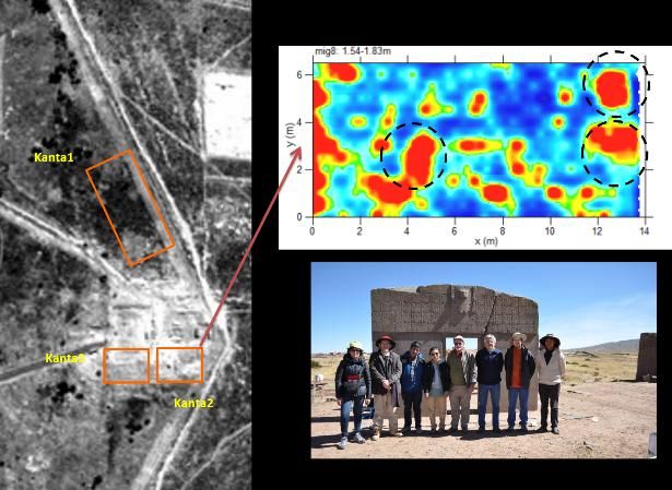
Tiwanaku Bolivia
.- Investigation campaigns
May 2009; June 2014
Highlights
2009: Satellite and geophysical maps of archaeological features near Kantatallita
2014: Archaeogeophysiv+cal maps of Akapana, Kantatallita, Puma Punku and Templete in the ceremonial
center of Tiwanaku
23B3.3 Publications
Lasaponara R., Masini N. 2014. Beyond modern landscape features: New insights in the
archaeological area of Tiwanaku in Bolivia from satellite data. International Journal of Applied
Earth Observation and Geoinformation, 26, 464–471
And numerous project report in English and Spanish
24Scientific and professional activity in the field of cultural heritage in
UNESCO sites :Italy
_ Italy Matera
.- Investigation campaigns 2012-2014: Scientific responsible of the MITRA project
(http://www.progettomitra.net/)
space monitoring of land degradation
Interferometry
Space Monitoring of Neolithic remains
_Rome (Italy)
.- Investigations
2013-14: Deformation monitoring of the historical centre of Rome by Interferometry processing of
SAR data (team : Francesca Cigna, Rosa Lasaponara, Nicola Masini, Pietro Milillo, Deodato
Tapete
Publications
Francesca Cigna, Rosa Lasaponara, Nicola Masini, Pietro Milillo, Deodato Tapete, Persistent
Scatterer Interferometry processing of COSMO-SkyMed StripMap HIMAGE time series to depict
deformation of the historic centre of Rome, Italy, in Remote sensing, in print.
C Stewart, R Lasaponara, G Schiavon Multi-frequency, polarimetric SAR analysis for
archaeological prospection International Journal of Applied Earth Observation and Geoinformation
28
25Scientific and professional activity in the field of cultural heritage in
UNESCO sites : Africa and Middle EAST
Lybia Sabratha
.- Investigations
June 2013: detection of archaeological features (microrelief) by Cosmo Sky Med (see figures
below)
1. C Stewart, R Lasaponara, G Schiavon 2013 ALOS PALSAR analysis of the archaeological
site of Pelusium Archaeological Prospection 20 (2), 109-116
26Scientific and professional activity in the field of cultural heritage in
UNESCO sites : Turkey
Hierapolis Turkey
Investigations
August 2010: partecipation at the archaeogeophysical campaign in the context of the scientific
activities of the Archaeological Mission of Hierapolis (Director F. D’Andria; team: G. Leucci, N.
Masini, R. Persico)
2008, 2014: archaeological prediction models for the detection of roman/hellenistic farms in the
territory of Hierapolis (R. Lasaponara, N. Masini, G. Scardozzi).
B8.2.- Publications
Lasaponara R., Masini N., and Scardozzi G. 2008, New perspectives for satellite-based archaeological
research in the ancient territory of Hierapolis (Turkey), Advances in Geosciences, 19, 87-96.
R. Lasaponara, N. Masini, G. Scardozzi, Satellite-based archaeological research in the ancient territory of
Hierapolis (Turkey), in Advances in Remote Sensing for Archaeology and Cultural Heritage Management,
R. Lasaponara & N. Masini (Eds), Aracne, Roma, 2008, ISBN: 978-88-548-2030-2 , pp. 11-16
Lasaponara R., Masini N., Scardozzi G. 2010, Elaborazione di immagini satellitari ad alta risoluzione e
ricognizione archeologica per la conoscenza degli insediamenti rurali del territorio di Hierapolis di Frigia
(Turchia), in F. D’Andria, D. Malfitana, N. Masini, G. Scardozzi (a cura di), Il Dialogo dei saperi.
Metodologie integrate per i beni Culturali, ESI, Napoli, vol. II, pp. 479-494, ISBN: 8849519117.
Lasaponara R., Leucci G. Masini N., Persico R., and Scardozzi G. 2014, Remote sensing
integrated approach for preventive archaeology: the ancient rural farms in Phrygia (Turkey),
Remote Sensing, vol 6, in print.
27Educational and dissemination activities in cooperation with
UNESCO
I set up (2007) and currently chair the special interest group " Remote Sensing for natural and
cultural heritage" of the European Association of Remote Sensing Laboratories (EARSeL) in
cooperation with and supported by UNESCO (http://www.ibam.cnr.it/earsel/)
I am (and the ARGON laboratory I lead) Involved in the UNESCO Open Initiative
http://www.unesco.org/new/en/natural-sciences/science-technology/space-activities/space-for-
heritage/unesco-space-network/private-and-international-partners/earsel/
Educational
2013 organization and scientific responsible of the II ESA course on the use of remote sensing
for archaeology
Second ESA Remote Sensing and Cultural Heritage course “Radar Remote Sensing applications for
the study and observation of archaeological sites", in the frame of the IV International EARSeL
Workshop on "Advances in Remote Sensing for Archaeology and Cultural Heritage Management",
Matera (Italy), June 3-5, 2013 (http://www.earsel.org/SIG/NCH/2013-2nd-RS-CH-
Course/index.php)
2012 organization and scientific responsible of the I ESA course on the use of radar remote
sensing for archaeology
First Remote Sensing and Cultural Heritage course “Radar Remote Sensing applications for the
study and observation of archaeological sites", in the frame of the III International EARSeL
Workshop on "Advances in Remote Sensing for Archaeology and Cultural Heritage Management",
Ghent (Belgium), September 17-18, 2012 (http://w3.uniroma1.it/geodgeom/corsi-convegni-
educazione/2012-Corso%20Ghent/Home.htm)
28Dissemination
Exhibition Sensing the Past: COSMO-SkyMed and radar technologies for Archaeology in the
framework of European Space Expo
http://www.asi.it/it/press_room/comunicati_stampa/sensing_the_past_cosmoskymed_and_radar_tec
hnologies_for_archaeology
Chair of Conferences and Workshops focused on the use of Remote Sensing for Cultural
Heritage carried out with the UNESCO Patronage
Workshops:
4th EARSeL Workshop on Cultural and Natural Heritage, 6th - 7th June 2013 Matera, Italy.
3th EARSeL Workshop - “Advances in Remote Sensing for Archaeology and Culturale Heritage
Management”, Gent, 19-22 September 2012.
2th EARSeL Workshop joint with AARG - “Ambitions and Realities. Remote Sensing for
Archaeology, Research and Conservation”, Poznan, 21-24 September 2011.
1th International EARSeL Workshop - “Advances in Remote Sensing for Archaeology and
Culturale Heritage Management” , Rome 30 September-4 October 2008.
Sessions on Remote Sensing for Cultural Heritage within EARSeL Symposium and UNESCO
Patronage
32th Annual EARSeL Symposium, Mykonos, 21-24 May 2012
31th Annual EARSeL Symposium, Prague, 30 May – 2 June 2011
30th Annual EARSeL Symposium, Paris, 31 May – 3 June 2010 held at the UNESCO
headquarter in Paris
29th Annual EARSeL Symposium, Chania, 15-18 June 2009
28 th Annual EARSeL Symposium, Istambul Turkey , 15-18 June 2008
29C)
CONFERENCES
SCIENTIFIC COMMITTEE
EDITORIAL BOARD
30C) INTERNATIONAL CONFERENCES AND WORKSHOPS
C.1 ASSOCIATE EDITOR OF INTERNATIONAL JOURNALS
She is Editor of NHESS
She is component of the Editorial Board of
Remote Sensing
Sensor
Journal of Remote Sensing & GIS
American Journal of Engineering and Applied Sciences
Studies in Surveying and Mapping Sciences
Open Journal of Remote Sensing and Positioning
Archaeology
C.2 GUEST EDITOR OF INTERNATIONAL JOURNALS
She is/has been Guest Editor of the following special issues of international
journals :
Journal of Cultural Heritage, vol. 10S (2009), entitled: “ICT and Remote sensing for
Cultural Resource Management and Documentation” (guest editors Lasaponara R., Masini
N.)
Photo Interpretation European Journal of Applied Remote Sensing , vol. 46 (2010),
entitled “Aerial and Spatial Archaeology : From the Historical Photographs to Lidar"
(guest editors Lasaponara R., Hernandez M., Masini N., Deroin J.-P.)
Journal of Archaeological Science, vol. 38 (2011), entitled : " Satellite remote sensing in
archaeology: past, present and future perspectives” (guest editors Rosa Lasaponara, Nicola
Masini)
Archaeological Prospection, 20 (2013), entitled: “ Satellite Radar in Archaeology and
Cultural Landscape” (Guest editors: Rosa Lasaponara & Nicola Masini)
International Journal of Applied Earth Observation and Geoinformation, 26 (2014),
entitled: “Advance in geocomputation” (Guest editors: Lasaponara R., Murgante B., Masini
N., Yong Ge, Asche H.)
C.3 CHAIR OR CO-CHAIR OF INTERNATIONAL CONFERENCES AND WORKSHOPS
2008
Chair of the I EARSeL Workshop “Advances in Remote Sensing for Archaeology and Cultural
Heritage Management” Rome, on 1-3 October 2008
2008
Chair of theVII EARSeL Workshop “Advances in Remote Sensing for forest fire” Matera, on 1-
3 September 2009
312011
Santander (Spagna), 20-23 June 2011. Chair of the Workshop : “Remote sensing Data Analysis,
modeling, interpretation and Applications: from a global view to a local analysis”, within
Conference ICCSA (International Conferences on Computational Science and Its Applications)
2011
2012
Salvador de Bahia (Brasile), 18-21 June 2012. Chair of the Workshop : “Remote sensing Data
Analysis, modeling, interpretation and Applications: from a global view to a local analysis”,
within Conference ICCSA (International Conferences on Computational Science and Its
Applications) 2012
2013
Matera (Italia), 3-6 June 2013. Chair of the 33rd EARSeL Symposium 2013 “Towards Horizon
2020: Earth Observation and Social Perspectives”
Matera (Italia), 6-7 June 2013. Chair of the 4th EARSEL Workshop on Cultural and Natural
Heritage in conjunction with the 33rd EARSeL Symposium 2013
Ho Chi Minh City (Vietnam), 24-27 June. Chair of the Workshop : “Remote sensing Data
Analysis, modeling, interpretation and Applications: from a global view to a local analysis” within
ICCSA Conference 2013
Potenza (Italia), 4 October 2013. Chair of the 1st International Workshop of the MITRA project
: "Cultural heritage between knowledge and monitoring. Multiscale approaches and smart
technologies"
Potenza (Italia), 4 September 2014. Chair of the II International Workshop of the MITRA
project : "Cultural heritage between knowledge and monitoring. Multiscale approaches and smart
technologies"
C.4 CONVENER OF SCIENTIFIC SESSIONS WITHIN INTERNATIONAL CONFERENCES AND SYMPOSIUM
2007
Firenze, 17-20 september 2007. Spie Europe Remote Sensing Symposium. Convener of session
on “Remote sensing for archaeology, cultural and natural heritage”, within the Conference
“Remote Sensing for Environmental Monitoring, GIS Applications, and Geology”.
2008
Cardiff, 15-19 september 2008. Spie Europe Remote Sensing Symposium. Convener of session on
“Remote sensing for archaeology, cultural and natural heritage”, within the Conference “Remote
Sensing for Environmental Monitoring, GIS Applications, and Geology”.
2009
Wien, 19-24 April. EGU General Assembly. Co-convener of the session on NP4“satellite time
series analysis”
Berlin, 31 august – 3 september 2009. Spie Europe Remote Sensing Symposium. Covener of
session on “Remote sensing for archaeology, cultural and natural heritage”, within the Conference
“Remote Sensing for Environmental Monitoring, GIS Applications, and Geology”.
2010
Wien, 2-7 May. EGU General Assembly. Convener of the session NP4“satellite time series
analysis”
C.5 MEMBER OF SCIENTIFIC AND/OR PROGRAMME COMMITTEE OF INTERNATIONAL
CONFERENCES
2007
32Firenze, 17-20 September 2007. Spie Europe Remote Sensing Conference. Member of the
Programme Committee of the Conference “Remote Sensing for Environmental Monitoring, GIS
Applications, and Geology”.
2008
Cardiff, 15-19 september 2008. Spie Europe Remote Sensing Conference. Member of the
Programme Committee of the Conference “Remote Sensing for Environmental Monitoring, GIS
Applications, and Geology”.
Rome, on 1-3 October 2008. Member of the Scientific and Programme Committee of the I
EARSeL Workshop “Advances in Remote Sensing for Archaeology and Cultural Heritage
Management”
2009
Kyung Hee University-Global Campus, Yongin (Korea), June 29th –July 2nd. Member of the
Programme Committee of the Fourth International Workshop on "Geographical Analysis, Urban
Modeling, Spatial Statistics" GEOG-AN-MOD 09.
Berlin, 31 august – 3 september 2009. Spie Europe Remote Sensing Conference. Member of the
Programme Committee of Conference “Remote Sensing for Environmental Monitoring, GIS
Applications, and Geology”.
2010
Fukuoka (Giappone), 23-26 March 2010. Member of the Programme Committee of the 5th
Workshop on "Geographical Analysis, Urban Modeling, Spatial Statistics" GEOG-AN-MOD 10
Maryland, USA 28-30 July 2010. Member of Programme Committee of the Workshop Intelligent
Spatial Decision Analysis ISDA '10 in conjunction with International Symposium on Intelligent
Decision Technologies (IDT'10)
2011
Gosier, Guadeloupe (France) February 23-28, 2011. Member of the Technical Program
Committee of the Third International Conference on Advanced Geographic Information Systems,
Applications, and Services: GEOProcessing 2011
2012
Valencia, January 30-February 4, 2012. Member of the Technical Program Committee of “The
Forth International Conference on Advanced Geographic Information Systems, Applications, and
Services: GEOProcessing 2012”.
2013
Paphos (Cyprus), 8-10 April 2013.. Member of the Internationa Scientific Committee of the “First
International Conference on Remote Sensing and Geoinformation” (RSCy 2014)
Matera (Italia), 3-6 giugno. Member of the International Scientific Committee e Organizing
Committee of the 33rd EARSeL Symposium 2013 “Towards Horizon 2020: Earth Observation and
Social Perspectives”
Ho Chi Minh City (Vietnam), 24-27 giugno. Member of the Programme Committee of the 33rd
International Conferences on Computational Science and Its Applications – ICCSA 2013
Danang (Vietnam), 18-21 Dicembre 2013. Member of the International Scientific Committee of
the “5th FTRA International Conference on Computer Science and its Applications (CSA-13)
332014
Paphos (Cyprus), 7-10 April 2014. Member of the Internationaò Scientific Committee of the
“Second International Conference on Remote Sensing and Geoinformation”. (RSCy 2014)
Lemessos (Cyprus), 3-8 November 2014. Member of the International Scientific Committee of the
International Conference on Cultural heritage - Euromed 2014.
2015
Paphos (Cyprus), 16-19 March 2015. Member of the Internationaò Scientific Committee of the
“Third International Conference on Remote Sensing and Geoinformation”. (RSCy 2015)
C.6 CHAIRPERSON OF SCIENTIFIC SESSIONS OF INTERNATIONAL CONFERENCES
2008
Rome, 1-3 october 2008. I EARSeL Workshop “Advances in Remote Sensing for Archaeology
and Cultural Heritage Management”. Chairperson of the session : “3D visualization and Virtual
reconstruction of landscape and sites”
2009
Wien, 23 April. EGU General Assembly. Chairperson of the oral session “NP4“satellite time
series analysis”
”
Berlin, 31 august – 3 september 2009. Spie Europe Remote Sensing Conference. Chairperson of
the session “Archaeology, Cultural and Natural Heritage Geospatial Infrastructure II”
2010
Fukuoka (Giappone), 23-26 march 2010. 5th Workshop on "Geographical Analysis, Urban
Modeling, Spatial Statistics" GEOG-AN-MOD 10. Chairperson of the session “Geosimulation of
urban phenomena”, 23 march 2010..
Wien, 2-7 May. EGU General Assembly. Chairperson of the oral session “NP4“satellite time
series analysis”
2011
Vienna, 3-8 aprile. EGU General Assembly. Chairperson of the oral session NP4“satellite time
series analysis”
2012
Vienna, 22-27 aprile. EGU General Assembly. Chairperson of the oral session NP4“satellite
time series analysis”
Salvador de Bahia (Brazil), 18-21 June Chairperson of the oral session of the Workshop :
“Remote sensing Data Analysis, modeling, interpretation and Applications: from a global view to
a local analysis” nell’ambito della Conferenza ICCSA 2012
2013
34Vienna, 7-12 April. EGU General Assembly. Chairperson of the oral session NP4“satellite time
series analysis”
C.10 REVIEWER OF JOURNAL, PROCEEDINGS AND PROJECTS
C10.1 Reviewer for the following journals
American Journal of Engineering and Applied Sciences
Archaeometry
Geological Society of London
IEEE Journal of selected topics in applied earth observations and remote sensing (j-stars)
International Journal of Digital Earth
International Journal of Geophysics
International Journal of Remote Sensing
Journal of Archaeological Science
Journal of Cultural Heritage
Journal of Geophysics and Engineering
Near Surface Geophysics
Remote Sensing
Sensors
Applied Energy
Construction & Building Materials
The Egyptian Journal of remote Sensing and Space sciences
Journal on Computing and Cultural Heritage
Natural Hazards and Earth System Sciences
C10.2 Reviewer for the following Proceedings of International Conferences
Geoprocessing (2010)
ICCSA (2010, 2011, 2012)
EARSeL symposium aqnd workshops (2008-12)
CAA – Computer Applications and Qualitative methods in Archaeology (2012, 2013)
C10.3 Reviewer for the following International Research Projects and Programme
Research Programme for Earth Observation "Stereo II" (2006-13) BELSPO (Belgium)
Portuguese Foundation for Science and Technology (FCT): proposal PTDC/EPH-ARQ/5201/2012.
Title: Multi-source 4d mapping Conimbriga: high tech tools for the diachronic study of ancient
Urbanism
C.11 Member of Committee/Panels
2012
Member of the Italian National Consultant Panel as stakeholder of activities of the Joint
Programming Initiative on “Cultural Heritage and global change: a new Challenge for Europe”
3536
D. PUBLICATIONS

                  37
D) LIST OF PUBLICATIONS
D.1A) PAPERS ON INTERNATIONAL JCR JOURNALS (ISI).
2. Lasaponara R., Leucci G. Masini N., Persico R., and Scardozzi G. 2014, Remote sensing
integrated approach for preventive archaeology: the ancient rural farms in Phrygia (Turkey),
Remote Sensing, vol 6, in print.
3. G Nolè, B Murgante, G Calamita, A Lanorte, R Lasaponara 2015 Evaluation of Urban
Sprawl from space using open source technologies Ecological Informatics DOI:
10.1016/j.ecoinf.2014.05.005 in print.
4. C Stewart, R Lasaponara, G Schiavon Multi-frequency, polarimetric SAR analysis for
archaeological prospection International Journal of Applied Earth Observation and
Geoinformation 28
5. D Tapete, F Cigna, R Lasaponara, N MasiniMulti-scale Detection of Changing Cultural
Landscapes in Nasca (Peru) Through ENVISAT ASAR and TerraSAR-X Engineering
Geology for Society and Territory-Volume 8, 339-343
6. Danese M., Masini N., Biscione M., Lasaponara R. 2014. Predictive modeling for preventive
Archaeology: Overview and case study. Central European Journal of Geosciences. March
2014,Volume 6, Issue 1, 42-55
7. Lasaponara R., Leucci G., Masini N., Persico R. 2014. Investigating archaeological looting
using satellite images and georadar: the experience in Lambayeque in North Peru. Journal of
Archaeological Science, 42, 216-230, http://dx.doi.org/10.1016/j.jas.2013.10.032
8. Lasaponara R., Masini N. 2014. Beyond modern landscape features: New insights in
thearchaeological area of Tiwanaku in Bolivia from satellite data. International Journal of
Applied Earth Observation and Geoinformation, 26, 464–471,
http://dx.doi.org/10.1016/j.jag.2013.09.00.
9. Lasaponara R., Murgante B., Masini N., Yong Ge, Asche H. 2014. Advance in
geocomputation. International Journal of Applied Earth Observation and Geoinformation, 26,
429–431, http://dx.doi.org/10.1016/j.jag.2013.10.004
10. Lasaponara R., Masini N. 2013, Satellite Synthetic Aperture Radar in Archaeology and
Cultural Landscape: An Overview. Archaeological Prospection, 20, 71-78, doi:
10.1002/arp.1452
11. C Stewart, R Lasaponara, G Schiavon 2013 ALOS PALSAR analysis of the archaeological
site of Pelusium Archaeological Prospection 20 (2), 109-116
12. Cigna F., Tapete D., Lasaponara R., Masini N., Amplitude change detection with ENVISAT
ASAR to image the cultural landscape of the Nasca region, Peru¸ Archaeological Prospection,
20, 117-131, doi: 10.1002/arp.145
13. Tapete D., Cigna F., Masini N., Lasaponara R., Prospection and monitoring of the
archaeological heritage of Nasca, Peru, with ENVISAT ASAR, Archaeological Prospection,
20, 133-147, doi: 10.1002/arp.144
14. Lasaponara R., Masini N., Holmgren R., Backe Forsberg Y., Integration of aerial and
satellite remote sensing for archaeological investigations: a case study of the Etruscan site San
Giovenale , Journal of Geophysics and Engineering, vol. 9, S26-S39, doi:10.1088/1742-
2132/9/4/S26.
15. Lasaponara R., Masini N. 2011, Satellite Remote Sensing in Archaeology : past, present and
future, Journal of Archaeological Science, 38, 1995–2002, doi:10.1016/j.jas.2011.02.002.
16. Lasaponara R., Masini N., Rizzo E., Orefici G. 2011. New discoveries in the Piramide
Naranjada in Cahuachi (Peru) using satellite, Ground Probing Radar and magnetic
38investigations, Journal of Archaeological Science, 38, 2031-2039,
doi:10.1016/j.jas.2010.12.010.
17. Lasaponara R., Coluzzi R., Masini N., 2011, Flights into the past: Full-Waveform airborne
laser scanning data for archaeological investigation, Journal of Archaeological Science, 38,
2061-2070, doi: 10.1016/j.jas.2010.10.003.
18. Rizzo E., Masini N., Lasaponara R., Orefici G. 2010, ArchaeoGeophysical methods in the
Templo del Escalonado (Cahuachi, Nasca, Perù), Near Surface Geophysics 8, 433-439,
doi:10.3997/1873-0604.2010030.of the Monumental Heritage, Journal Geophysics
Engineering 7, 190-199, doi:10.1088/1742-2132/7/2/S05.
19. Lasaponara R., Coluzzi R., Gizzi F.T., Masini N. 2010, On the LiDAR contribution for the
archaeological and geomorphological study of a deserted medieval village in Southern Italy,
Journal Geophysics Engineering, 7, pp. 155-163, doi:10.1088/1742-2132/7/2/S01.
20. Masini N., Lasaponara R. N., Orefici G. 2009, Addressing the challenge of detecting
archaeological adobe structures in Southern Peru using QuickBird imagery, Journal of Cultural
Heritage, 10S, pp. e3–e9 [doi:10.1016/j.culher.2009.10.005].
21. Lasaponara R., Masini N. 2009, Full-waveform Airborne Laser Scanning for the detection of
medieval archaeological microtopographic relief, Journal of Cultural Heritage, 10S, pp. e78–
e82 [doi:10.1016/j.culher.2009.10.004].
22. Lasaponara R., Masini N. 2009, Editorial of Special Issue on “Remote Sensing for Cultural
Heritage Management and Documentation”, Journal of Cultural Heritage, 10S, pp. e1–e2
[doi:10.1016/j.culher.2009.10.006].
23. Ciminale M., Gallo D., Lasaponara R., Masini N. 2009, A Multiscale Approach for
Reconstructing Archaeological Landscapes:Applicationsin Northern Apulia (Italy),
Archaeological Prospection, 16, pp. 143–153 [doi: 10.1002/arp.356].
24. Lasaponara R., Masini N. 2007, Detection of archaeological crop marks by using satellite
QuickBird, Journal of Archaeological Science, 34, pp. 214-221 [ISSN: 0305-4403]
[10.1016/j.jas.2006.04.014].
25. Masini N., Lasaponara R. 2007, Investigating the spectral capability of QuickBird data to
detect archaeological remains buried under vegetated and not vegetated areas , Journal of
Cultural Heritage, 8 (1), pp. 53-60. [ISSN: 1296-2074]
26. Masini N., Lasaponara R. 2006, Satellite-based recognition of landscape archaeological
features related to ancient human transformation, Journal of Geophysics and Engineering, 3,
pp. 230-235. [ISSN: 1742-2132] [doi:10.1088/1742-2132/3/3/004]
27. Lasaponara R., Masini N. 2006, Identification of archaeological buried remains based on
Normalized Difference Vegetation Index (NDVI) from Quickbird satellite data, IEEE
Geoscience and Remote Sensing Letters, vol. 3(3), pp. 325-328 [ISSN: 1545-598X] [doi:
10.1109/LGRS.2006.871747]
28. Lasaponara R., Masini N. 2006, On the potential of Quickbird data for archaeological
prospection, International Journal of Remote Sensing, 27 (15-16), pp. 3607-3614. [ISSN:
0143-1161] [DOI: 10.1080/01431160500333983]
29. Lasaponara R., Masini N. 2005, QuickBird-based analysis for the spatial characterization of
archaeological sites: case study of the Monte Serico Medioeval village, Geophysical Research
Letter, 32(12), L12313 [ISSN: 0094-8276] [doi:10.1029/2005GL022445] Impact factor :
2,959.
39D.1B) PAPERS ON INTERNATIONAL JOURNALS (NON JCR)
30. R. Lasaponara, N. Masini 2013. Remote Sensing in Archaeology: an overview, Journal of
Aeronautics and Space Technologies, 6 (1), 7-17
31. Masini N., Lasaponara R., Lancho Rojas J. 2011. On the contribution of satellite data for
archaeological research in the Nazca Basin: spanning from site discovery and documentation to
palaeo-environmental investigations, Thule. Rivista italiana di studi americanistici, vol. 30/31, pp.
81-118.
32. Lasaponara R., Masini N., Rizzo E., Orefici G. 2011. On the capability of Very High
Resolution satellite and Ground Probing radar techniques for detecting buried archaeological adobe
structures, Revue française de photogrammétrie et de télédétection, 193, pp. 61-70, ISSN 1768-
9791.
33. Masini N., Coluzzi R., Lasaponara R. 2010, Investigating lost medieval villages using
Satellite and Airborne Laser Scanning: the case of Yrsum in Basilicata (Southern Italy),
Archeologia e Calcolatori, 121, pp. 127-144.
34. Masini N., Ciriello R., Marchetta I., Guariglia A., Coluzzi R., Lasaponara R. 2011, Lidar e
ricognizioni sul campo: integrazione dati per la ricostruzione della forma urbana di un villaggio
medievale abbandonato. Il caso di Monteserico, Archeologia Aerea, 5, pp. 273-282
35. Masini N., Coluzzi R., Lasaponara R. 2010. Contribution d’un système Lidar pour la
reconctruction de la traime urbaine d’un village médiéval abandonné, Photo Interpretation
European Journal of Applied Remote Sensing, 46: 21-27, 30-40.
36. Lasaponara R., Masini N., and Scardozzi G. 2008, New perspectives for satellite-based
archaeological research in the ancient territory of Hierapolis (Turkey), Advances in Geosciences,
19, 87-96 [ISSN: 1680-7340]
37. Masini N., Rizzo E., Lasaponara R., and Orefici G. 2008, Integrated remote sensing
techniques for the detection of buried archaeological adobe structures: preliminary results in
Cahuachi (Peru), Advances in Geosciences, 19, 75-82. [ISSN: 1680-7359]
38. Lasaponara R., Masini N., Scardozzi G. 2007, Immagini satellitari ad alta risoluzione e
ricerca archeologica: applicazioni e casi di studio con riprese pancromatiche e multispettrali di
QuickBird, in Archeologia e Calcolatori, 18, pp. 187-227. [ISSN: 1120-6861]
D.2) PATENT
Lasaponara R lanorte Antonio
An Integarted system for Fire monitoring Patent prot. 408719 del 24 agosto 2009
sistema di lotta attiva agli incendi boschivi, n. 2008 A0016
D.3A) EDITORS OF SPECIAL ISSUES ON INTERNATIONAL JCR JOURNALS (ISI)
39. Lasaponara R., Murgante B., Masini N., Yong Ge, Asche H. 2014. Special issue on
“Advance in geocomputation “, International Journal of Applied Earth Observation and
Geoinformation, 26.
40. Lasaponara R., Masini N. 2013. Special issue on “Satellite Radar in Archaeology and
Cultural landscape”, Archaeological Prospection, vol. 20, issue 2
41. Lasaponara R., Masini N. 2011, Special Issue on “Satellite remote sensing in archaeology: past,
present and future perspectives”, Journal of Archaeological Science, vol. 38.
40You can also read