Daily Operations Briefing - Wednesday, September 8, 2021 8:30 a.m. ET - GovDelivery
←
→
Page content transcription
If your browser does not render page correctly, please read the page content below
FEMA National Watch Center

Daily Operations Briefing
  Wednesday, September 8, 2021
             8:30 a.m. ET
National Current Ops / Monitoring
New Significant Incidents / Ongoing Ops   Hazard Monitoring
▪ Tropical Cyclone Ida – Recovery         ▪   Severe thunderstorms possible – Mid-Atlantic to Northeast
▪ Wildfire Activity – Western U.S.        ▪   Heavy rain and flash flooding possible – Mid-Atlantic to Northeast
                                          ▪   Critical fire weather – Northern Rockies
  o Caldor Fire – CA
                                          ▪   Tropical Activity
                                              o Atlantic:
                                                  • Hurricane Larry (CAT 3)
                                                  • Disturbance 1: Medium (50%)
                                                  • Disturbance 2: Low (20%)
                                              o Eastern Pacific:
                                                  • Tropical Depression Fifteen-E
                                                  • Disturbance 1: Low (20%)

Disaster Declaration Activity             Event Monitoring
▪ Amendment No. 1 to FEMA-4611-DR-LA      ▪ United Nations General Assembly

                                                               Federal Emergency Management Agency
                                                                                   National Watch Center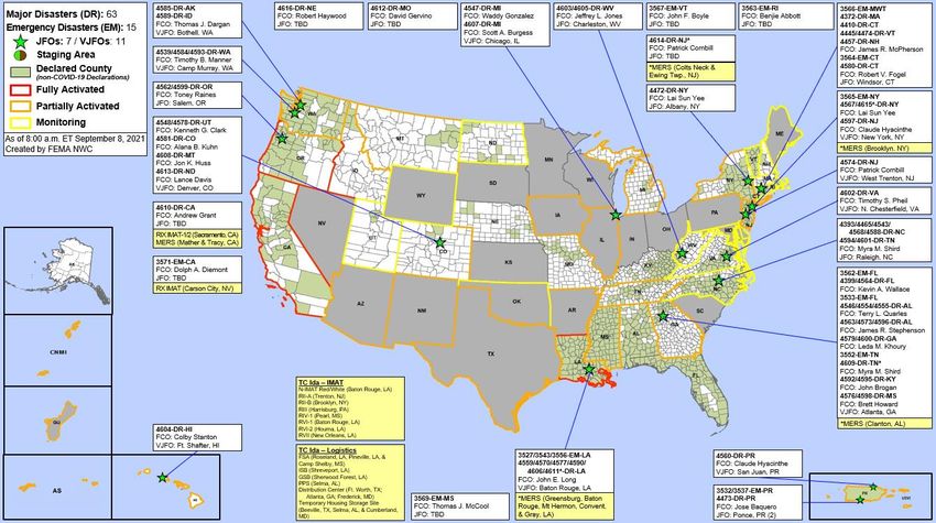
Tropical Cyclone Ida
Situation: Priorities remain power, fuel, hospitals and medical.
FEMA / Federal Response:
FEMA HQ:
▪ NRCC at Level III, 24/7; NWC is monitoring
▪ Major Disaster Declaration FEMA-4611-DR-LA; JFO established in Baton
  Rouge, LA
▪ Major Disaster Declaration FEMA-4614-DR-NJ approved on Sep 5
▪ Major Disaster Declaration FEMA-4615-DR-NY approved on Sep 5
▪ Emergency Declarations: approved for LA, MS, NJ and NY
▪ National IMAT Red and White deployed to Baton Rouge, LA
▪ Region VII IMAT deployed to New Orleans, LA
▪ MERS: Denton, Denver, Thomasville, Maynard, and Frederick supporting

                                                                         National Watch Center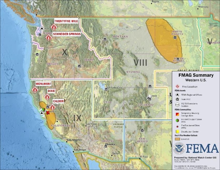
Tropical Cyclone Ida – Region VI                                                                          LA

Lifeline Impacts: (Tropical Cyclone Ida SLB as of 6:00 a.m. ET, Sep 8)
Safety and Security:
▪ LA: Mandatory evacuations for 5 (-4) parishes; voluntary evacuations for 2 (-9) parishes (FEMA-
   4611-DR-LA SitRep #5, Sep 7)
Food, Water, Shelter:
▪ LA: 223 (-8) Boil Water Advisories in effect impacting 585k (-262k) people; 43 (-19) water
   system outages affecting 62k (+4k) people
▪ LA: 15 (-1) shelters open with 1,584 (+218) occupants (ARC Midnight Shelter Count as of 7:01 a.m. ET)
Health and Medical:
▪ LA: 15 (-1) hospitals fully evacuated; 18 (-7) hospitals on generator power; 21 (-2) nursing
   homes fully evacuated; 35 (+4) nursing homes on generators; 47 assisted living facilities fully
   evacuated, 21 on generators
Energy:
▪ LA: 353k (-79k) (16%, -3%) customers without power (DOE Eagle-I as of 5:45 a.m. ET)
▪ Most Entergy LA areas, including New Orleans East and Orleans Parish, expected to be
   restored today; full restoration to heavily impacted areas by Sep 29-30
Transportation:
▪ LA: Rail service to New Orleans area will not return to normal until Mays Rail Yard is open,
   debris removed, and power crews are on site; Amtrak service from New Orleans to Memphis
   suspended, line serves as an evacuation route for the city; affects 6 rail lines; no ETA for
   restoration
State / Local Response:
▪ LA EOC at Full Activation (TC Ida and COVID)
FEMA Region VI Response:
▪ RRCC at Level III, day shift only
▪ IMAT-1 deployed to Baton Rouge, LA
▪ IMAT-2 deployed to Houma, LA

                                                                                                               National Watch Center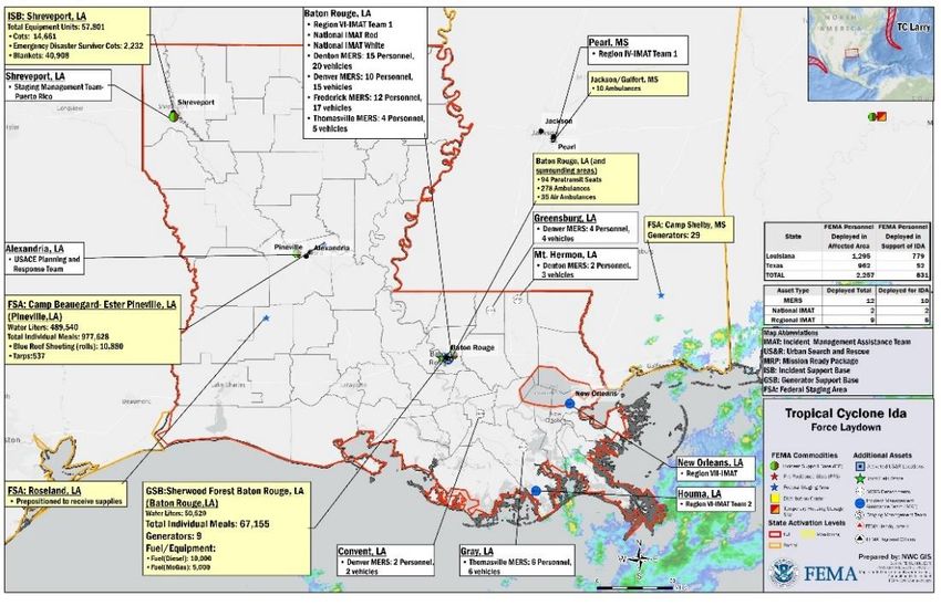
NJ

Tropical Cyclone Ida – FEMA Region II                                                     NY

Lifeline Impacts: (FEMA Region II SLB Sep 7, 2021, 1:30 p.m. ET)
Food, Water, Shelter:
• NJ: Congregate shelters: 1 (-1) with 28 (-6) occupants (Region II as of 7:26 a.m. ET)
▪ NY: Congregate shelters: 1 with 36 (-6) occupants; non-congregate shelters: 11
   with 16 occupants (ARC Midnight Shelter Count as of 7:01 a.m. ET)
Health and Medical:
▪ NY: 3 (-1) medical facilities impacted by flash flooding event; no evacuations
▪ NJ: 1 nursing home evacuated, 1 assisted living facility evacuated, 1 flooded
• Fatalities: NY: 17 confirmed; NJ: 27 confirmed
State / Local Response:
▪ NJ EOC at Partial Activation (Ida and COVID)
▪ NY EOC at Partial Activation (Ida and COVID)
FEMA / Federal Response:
▪ RRCC at Level III, 24/7, with ESFs 1, 7, 13
▪ IMAT deployed to NJ EOC; collateral IMAT deployed to Brooklyn, NY IOF
▪ LNOs deployed to NYC EOC; Westchester County, NY; NY state EOC, NJ EOC
▪ Emergency Declarations FEMA-3572-EM-NY and FEMA-3573-EM-NJ
▪ Major Disaster Declarations FEMA-4614-DR-NJ and FEMA-4615-DR-NY

                                                                                               National Watch Center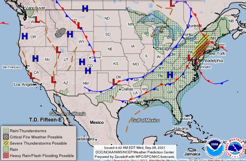
Tropical Outlook – Five Day
     Central Pacific                   Eastern Pacific                                                        Atlantic

                                                                                                           1
                                                                                                         (50%)                        1
                                                                                                                                    (20%)

                                                               1
                                                             (20%)

                       Tropical Depression Fifteen-E (Advisory #3 as of 5:00 a.m. ET)   Hurricane Larry (CAT 3) (Advisory #31 as of 5:00 a.m. ET)
                       ▪ 185 miles W of Manzanillo, Mexico                              ▪ 605 miles SE of Bermuda
                                                                                        ▪ Moving NW at 10 mph
                       ▪ Moving NNW at 3 mph
                                                                                        ▪ Maximum sustained winds 115 mph
                       ▪ Maximum sustained winds 35 mph
                                                                                        Disturbance 1 (as of 8:00 a.m. ET)
                       ▪ Expected to become a tropical storm later today,               ▪ Located over central and eastern Gulf of Mexico
                          could become a short-lived hurricane Thursday                 ▪ Expected to cross into the southeastern U.S.
                          or Thursday night                                             ▪ Could bring heavy rain to portions of Florida panhandle
                                                                                           and southern GA through Thursday
                       Disturbance 1 (as of 8:00 a.m. ET)                               ▪ Formation chance: 48 hours: Medium (50%);
                       ▪ Expected to form over the weekend a couple of                     5 days: Medium (50%)
                          hundred miles south of the southern coast of                  Disturbance 2 (as of 8:00 a.m. ET)
                          Mexico                                                        ▪ Expected to emerge off western coast of Africa in a few
                       ▪ Formation chance: 48 hours: Low (near 0%);                        days
                          5 days: Low (20%)                                             ▪ Formation chance: 48 hours: Low (near 0%);
                                                                                           5 days: Low (20%)

                                                                                                          National Watch Center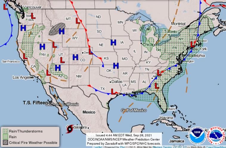
National Weather Forecast
                            Wed                           Thu

                                                          Fri

                                  National Watch Center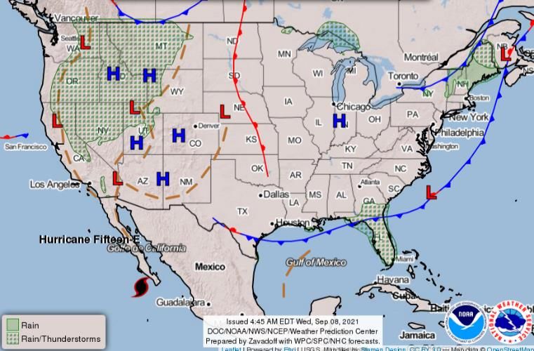
Severe Weather Outlook
                         Wed                           Thu

                                                       Fri

                               National Watch Center
Fire Weather Outlook

           Today       Tomorrow

                            National Watch Center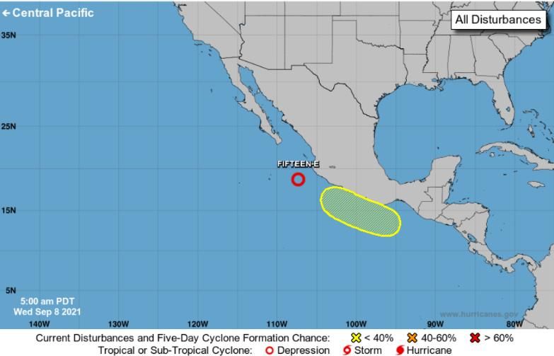
Space Weather Outlook
                                                                                                                    Solar                    Radio
                                            Space Weather Activity                     Geomagnetic Storms
                                                                                                                  Radiation                Blackouts
 Past 24 Hours                                          None                                       None             None                     None
 Next 24 Hours                                          None                                       None             None                     None
For further information on NOAA Space Weather Scales refer to: http://www.swpc.noaa.gov/noaa-scales-explanation
For further information on Sunspot Activity refer to: https://www.swpc.noaa.gov/phenomena/sunspotssolar-cycle

                                       HF Communication Impact                                                        Sunspot Activity

                                                                                                                              National Watch Center
Wildfire Summary
Structures (Homes / Other)
Fire Name Acres Percent Fatalities
FMAG # Evacuations
(County, ST) Burned Contained / Injuries
Threatened Damaged Destroyed
Dixie 919,300 M: 972 H: 5,927 H: 56 H: 704
5400-FM-CA 59% (+1) 1 / 10
(Plumas, CA) (+4,645) V: 0 O: 31 O: 36 O: 578
Monument 185,917 M: 7,600 H: 5,780 H: 3 H: 20
5412-FM-CA 42% (+1) 0/9
(Trinity, CA) (+1,777) V: 0 O: 4,800 O: 0 O: 30
M: 10,970 H: 776
H: 23,691 H: 51 (+1)
Caldor 217,007 (-731) (+24)
5413-FM-CA 50% (+2) 0/7
(El Dorado, CA) (+649) O: 220
V: 0 O: 956 O: 28 (+2)
(+7)
Twenty-five M: 0 H: 688 H: 0 H: 2
17,864 0 / 19
Mile 5414-FM-WA 40%
(+604) V: 0 O: 84 O: 0 O: 12 (+2)
(Chelan, WA)
Schneider M: 240 H: O H: 0 H: 0
94,206
Springs 5415-FM-WA 17% (+3) 0/7
(+1,431) V: O O: O O: O O: O
(Yakima, WA)
(Evacuations: M = Mandatory / V = Voluntary; Structures: H = Homes and Mixed Commercial/Residential / O = Non-residential Commercial/Other Minor Structures)
National Watch CenterNational Fire Activity (as of Sep 7)
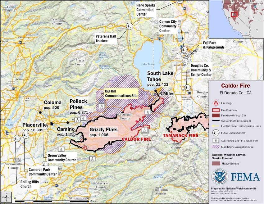
Caldor Fire – California
Situation: This is now California’s second worst fire season with over 2 million acres burned (DR-
5610-CA SLB #11 as of 3:00 p.m. ET, Sep 7). USDA Forest Service has temporarily closed all National
Forests in California through September 17, 2021. (Caldor 209 as of 11:00 p.m. ET, Sep 6) Critical
elements of infrastructure have been damaged or destroyed, including portions of E.I.D wooden
flumes, valued at $20 million, which are necessary for the transportation of potable water. A
critical fiberoptic line along Highway 50 has been destroyed and will have a significant effect on
communications. (Caldor ICS-209 as of 8:49 a.m. ET, Sep 7)
Impacts:
Safety and Security:
• Evacuations in CA, El Dorado County: portions of Grizzly Flat Road and String Canyon Road
  downgraded from Evacuation Orders to precautionary Warnings; evacuation warning lifted for
  South Sly Park (Caldor ICS-209 as of 8:48 a.m. ET, Sep7)
Food, Water, Shelter:
▪ 13 (-4) congregate shelters with 163 (-70) occupants; 7 (+1) non-congregate shelters with
  13 (+1) occupants across CA and NV (ARC Midnight Shelter Count as of 7:01 a.m. ET)
Energy:
• 1,597 (+284) (1.3%) customers without power in El Dorado County (DOE Eagle-I as of 6:30 a.m. ET)
State / Local Response:
▪ CA & NV EOCs at Full Activation (Wildfires and COVID); Governors issued States of Emergency
FEMA / Federal Response:
▪ Region IX RWC monitoring; IMAT-1 & IMAT-2 deployed to CA; LNOs deployed to CA and NV
▪ Region X IMAT deployed to NV
▪ FEMA Logistics Staging Management Team (SMT) deployed to Travis AFB, CA
▪ Incident Support Team (IST) deployed to Naval Air Station Fallon, NV
▪ NWC monitoring; NRCC at Level III, 24/7 (TC Ida)
▪ FEMA-4610-DR-CA approved for CA Wildfires; FEMA-3571-EM-CA approved for Caldor Fire

                                                                                                      National Watch Center
Joint Preliminary Damage Assessments
State / IA Number of Counties
Region Incident Start – End
Location PA Requested Complete
Severe Storms and Flooding IA 0 0 N/A
Jul 29-30 PA 2 0 TBD – TBD
NH
Severe Storms and Flooding IA 0 0 N/A
I
Jul 17-19 PA 3 2 8/4 – TBD
Severe Storms and Flooding IA 0 0 N/A
MA
Jul 16-21 PA 5 0 8/10 – TBD
Tropical Depression Ida IA 5 0 9/5 – TBD
PA
Sep 1 and continuing PA 0 0 N/A
III
Tropical Depression Ida IA 1 0 9/9-TBD
DE
Sep 1 and continuing PA 0 0 N/A
Tropical Cyclone Ida IA 8 0 TBD
IV MS
Aug 29 PA 0 0 N/A
Red Lake Tornado IA 1 1 8/30 – 9/1
V
Nation Jul 26 PA 1 0 8/30 – TBD
Flooding IA 7 0 8/24 – TBD
UT
Jul 15-Aug 19 PA 7 0 8/24 – TBD
VIII
Richard Spring Wildfire IA 0 0 N/A
MT
Aug 10 and continuing PA 3 0 9/7– TBD
Bootleg Fire IA 2 0 9/7 – TBD
X OR
Jul 6 PA 0 0 N/A
National Watch CenterDeclaration Requests in Process – 3
State / Tribe / Territory – Incident Description Type IA PA HM Requested
Fort Peck Assiniboine & Sioux Tribes – Severe Storm, Straight-line Winds, and Flooding DR X X Aug 3
NC –Tropical Storm Fred DR X X X Aug 27
AZ – Severe Storms and Flooding DR X X Sep 2
National Watch CenterDeclaration Amendments
Declaration Number Issued Action
Adds 7 parishes for permanent work (Categories C-G) under the Public Assistance program
FEMA-4611-DR-LA 1 7 Sep
(already designated for Individual Assistance and Categories A and B)
National Watch CenterFEMA Common Operating Picture
FEMA HQ N-IMATs
NWC NRCC
2-4 Teams Available
Monitoring Level III Red LA
White LA
FEMA REGIONS
Blue
Watch RRCC
Monitoring I Level III Gold
Monitoring II Level III R-IMATs
Monitoring III Level III
4-6 Teams Available
Monitoring IV Rostered
Alt Loc I 3
Monitoring
Nightshift V Level III
Monitoring VI Level III II NJ
Alt Location VII Rostered III PA
Monitoring VIII Rostered
IV-1 MS
Monitoring IX Rostered
Monitoring X Level III IV-2
Notes: V 1
NRCC: Ida
PR: Earthquakes VI-1 LA
RRCCs: COVID-19
NY, NJ, DE, MD, LA &
RII RRCC: Ida/COVID OK: TC Ida
VI-2 LA
RIII RRCC: Afghan
TX: Severe Weather VII LA
Repatriation
RV RWC: Day Shift / OR: Drought & Wildfires VIII 2
Monitoring
Night Shift / Remote MT, CO, AZ, CA, NV, ID, IX-1 CA
Ops & WA: Wildfires
RVII RWC: COVID-19
IX-2 CA
MI: Hazmat
Protocols
X NV
FMC PMC
NMC Deployed
US&R MERS FCOs IM IM CADRE AVAILABILITY SUMMARY
Team Status
33-65% 33-65% < 1 Type I WORKFORCE Cadres with 25% or Less Availability
Assigned: 28 36 57 14,271 (+7) Civil Rights: 17% (19/112); Disability Integration: 13% (8/60); Disaster Survivor Assistance: 20% (244/1,210)
Unavailable 6 (+2) 0 4 (+2) 3,654 (-140) External Affairs: 21% (113/528); Field Leadership: 15% (22/151); Hazard Mitigation: 19% (247/1,307);
Deployed: 4 (-2) 14 46 (27 (+1) FCOR) 7,109 (+39) Human Resources: 24% (48/204); Information Technology: 16% (99/607); Logistics 17% (243/1,426):
National Disaster Recovery Support: 23% (61/268); Operations: 17% (64/370); Public Assistance: 22%
25%(+1) / 3,508
Available: 18 22 7 (-2) (628/2,843); Planning: 6% (28/454); Safety:19% (15/80); Security 21% (29/136)
(+108)Helping people before, during, and after disasters.
Scan to subscribe to this briefing.You can also read