Danube news - International Association for Danube Research ...
←
→
Page content transcription
If your browser does not render page correctly, please read the page content below
ISSN 2070-1292

                                         danube news
                                          Bulletin of the International Association for Danube Research (IAD)
                                          Informationsblatt der Internationalen Arbeitsgemeinschaft Donauforschung (IAD)       donau aktuell

Tributaries of the Danube III:
Tisza – Floods: The oppressed beauty

Editorial
Dear Reader

    Meandering of rivers is a fascinating, wonderful feature
that can be seen in clear weather from airplanes. The active
and dead meanders display the great dynamics of flood-
plains over centuries behind the spectacular hydromorpho-
logical process. The Tisza River is just one fine example
(Figure 1). But, we also can see significant man-made
river straightening and degradation. To understand eco-
systems, it is sometimes good to have a broader per-
spective of a birds view than just to stand on the river banks
and see what is close.
                                                                                                                                                                      3 km
    The Tisza concludes the trilogy of major tributaries in the
Middle Danube. As the largest left-side confluence and                                          Figure 1. Signs of the westward drift of the Tisza River around the locality
                                                                                                of Tiszacsege on a digital elevation model. Elevation ranges from 87 m
flowing through the Pannonian Plains, the Tisza, fed by the                                     (dark blue) via green and yellow to 95 m (red). Black lines indicate the pre-
water-rich headwaters of Ukraine, was once a majestic                                           regulation channel of the river. Large cut-off meanders, open to the rivers,
meandering river that was severely “domesticated” during                                        are located east of the river. Adapted from Timár et al. (2005), Late Quater-
                                                                                                nary dynamics of the Tisza River: Evidence of climatic and tectonic controls,
the 19th century. Flooding was always a major issue in these
                                                                                                Tectonophysics 410, 97–110. Credit: Gábor Timár
lowlands, as resident farmers and settlements were strongly
affected. Today, the middle part of the Tisza with its many
oxbows and the Tisza Lakes offer a great restoration po-                                        pollution with hazardous substances remains an important
tential that, however, is in strong contrast to the many                                        concern for integrated water management of the Tisza River.
infrastructure projects planned for the future. Once more,
“sustainability” is on debate and the ecological problems                                            With Danube News 26, my term as editor ends. I was
can only be solved by a sound river basin management                                            intrinsically tied to Danube News from the very first issue in
including land use, headwaters and tributaries. Therefore,                                      1999 by supporting my predecessor Thomas Tittizer to
maintaining and fostering ecosystem services of the Tisza                                       launch and substantiate his idea for a basin-wide IAD
and considering public participation is in the hands of                                         Bulletin, and from 2006 by taking over editing and further
Ukraine, Slovakia, Romania, Hungary and Serbia, jointly                                         developing the structure and layout to what it is today an
united in the Tisza Group of the ICPDR.                                                         important and appreciated product of IAD to raise public
                                                                                                awareness and to promote Danube River protection and
    In 2000, the Tisza gained an European-wide poor repu-                                       restoration. I wish to thank all the readers for their conti-
tation via the two mine spills of Baia Mare and Baia Borsa.                                     nuous interest in IAD work and Danube News, and all
Although the ecological disaster killed numerous fish, inver-                                   success for my successor as Danube News editor, Georg
tebrates and birds, the riverine ecosystem recovered rather                                     Janauer.
rapidly. Although mining management and early warning
systems were partly improved, and when considering                                              Jürg Bloesch, Editor
increasing floods promoted by climate change, accidental                                        e-mail: bloesch@eawag.ch

Danube News – October 2012 – No. 26 - Volume 14                                                 Volume 10 - ISSN 2070-1292                                                      Page 1
The Tisza River Basin at a glance – natural values and risks

Diana Heilmann, Philip Weller, Mihaela Popovici: ICPDR, Vienna, Austria;            The Tisza River itself consists of three main sections:
e-mails: Diana.heilmann@unvienna.org, Philip.weller@unvienna.org,                   – The Upper Tisza, upstream of the mouth of the Someş/
Michaela.popovici@unvienna.org                                                        Szamos River;
The ICPDR Tisza Group experts as well as observers from the five countries of the   – The Middle Tisza in the Hungarian Great Plain, which
Tisza River Basin have contributed to the development of the documents serving        receives significant right- and left-side tributaries from
as the basis of the present article                                                   the Carpathian Mountains in Slovakia and Ukraine, the
                                                                                      Hungarian Mátra and Bükk Mountains, and Transylvania
The Tisza River (966 km) is the longest tributary of the                              in Romania;
Danube River, which flows through five countries: Ukraine,                          – The Lower Tisza, downstream of the mouth of the
Romania, Slovakia, Hungary and Serbia. The drainage area                              Mureş/Maros River, where it receives the Bega/Begej
of the Tisza River Basin (TRB) is 157186 km2, and it is the                           River and other tributaries indirectly via the Danube-Tisza-
largest sub-basin of the Danube River Basin (801463 km2).                             Danube Canal System.
It is home to approximately 14 million people. At its con-
fluence with the Danube the average flow of the Tisza is                                The drainage basins of the Tisza tributaries differ in
slightly over 800 m3/s. The TRB is blessed with rich bio-                           topography, soil composition, land use and hydrological
diversity but also faces significant risks due to human pres-                       characteristics (ICPDR 2007). The 1800–2500 m high ridge
sures as well as floods, drought and climate change.                                of the Carpathian Mountains forms in a semi-circle the
                                                                                    northern, eastern and southeastern boundary of the Tisza
Geographical and hydrological features                                              catchment. The western-southwestern reach of the water-
                                                                                    shed is comparatively low in some places – on its Hungarian
    The Tisza River rises in the Carpathian Mountains of                            and Serbian parts it is almost flat.
Ukraine and is formed by the confluence of the White and
                                                                                        The area is divided roughly along the centreline by the
Black Tisza Rivers. The Tisza River Basin (TRB) can be divided
                                                                                    Carpathian Mountains, east of which lies the 400–600 m
into two main parts with different geographical characteris-
                                                                                    high plateau of the Transylvanian Basin, and the plains to the
tics (Figure 1):
                                                                                    west. The river basin is varied and rich in eye-catching geo-
– The mountainous Upper Tisza and its tributaries in                                graphical formations. The highest summits reach 1948 m in
  Ukraine, Romania and the eastern part of Slovakia;                                the Low Tatras (Král’ova hol’a), 2061 m in the Chornogora
– The lowland parts, mainly in Hungary (the Great Hunga-                            Mountains (Hoverla), 2303 m in the Rodna Mountains (Piet-
  rian Plain-Alföld) and in Serbia, surrounded by the East-                         rosul Rodnei) and are even higher in the Retezat Mountains
  Slovak Plain, the Transcarpathian lowland (Ukraine), and                          of the Southern Carpathians (Peleaga, 2509 m). Areas higher
  the plains on the western fringes of Romania.                                     than 1600 m make up only 1% of the total; 46% of the basin
                                                                                                           lie below 200 m.
                                                                                                              Following the confluence of the
                                                                                                          White and Black Tisza Rivers further
                                                                                                          headwaters rise in the eastern moun-
                                                                                                          tains of Slovakia, two of them in the
                                                                                                          Narodny (National) Park. The Uzh/Uh
                                                                                                          and Latorytsa/Latorica tributaries flow
                                                                                                          from Ukraine into Slovakia where they,
                                                                                                          together with Ondava, Topl’a and
                                                                                                          Laborec Rivers, form the Bodrog River
                                                                                                          before it enters Hungary. Further, the
                                                                                                          Slaná/Sajó and Hornád/Hernád Rivers
                                                                                                          collect waters from the Carpathian
                                                                                                          Mountains in Slovakia and Ukraine.
                                                                                                          The Someş/Szamos and the Mureş/
                                                                                                          Maros rise in the Romanian Carpa-

                                                                                                          Figure 1. Map of the Tisza River Basin with eco-
                                                                                                          regions. Further maps with thematic managerial
                                                                                                          topics can be downloaded from
                                                                                                          http://www.icpdr.org/main/activities-projects/
                                                                                                          towards-itrmb-plan-component-1

Page 2                                                                                                        Danube News – October 2012 – No. 26 - Volume 14
thians, while the rivers forming the Cris/Körös system rise                    Mountains. Dry spells (with less than 10 mm/month) are
in the Apuseni Mountains. The TRB in Slovakia is predo-                        frequent in most areas of the TRB in February and March.
minantly hilly area and the highest mountain peaks in
                                                                                    In the mountainous regions, flash floods are common in
Král’ova hol’a, in the Low Tatras Mountain Range at 1948 m.
                                                                               spring and summer. These are further intensified by the low
The lowland area lies in the south, forming the northern edge
                                                                               infiltration capacity of the soils in the Carpathian Mountains.
of the Hungarian Lowland. The lowest point in Slovakia is the
                                                                               These floods cause enormous inundation in the lowland
village of Streda nad Bodrogom in the eastern Slovak lowland
                                                                               areas. Flooding is a natural event influencing riverine ecosys-
(96 m) in the Bodrog River Basin. The TRB in Romania is
                                                                               tems, but it is also a significant threat to communities settled
located in the northwest part of Romania and is charac-
                                                                               in the floodplain. Rainfall in the Carpathian Mountains can
terized by a high relief diversity: mountain areas (with ele-
                                                                               be substantial and sudden. Extensive runoff, floodplain de-
vations above 2000 m), hilly areas (400–800 m) and plain
                                                                               forestation and river canalization reduce the ability of the
areas (200–300 m). The Hungarian part of the TRB is a flat
                                                                               catchment to attenuate the flood wave. When heavy rains
area bordered by small ranges of hills and mountains from
                                                                               occur, flooding threatens human lives as water levels rise
the north and dominated by the Great Hungarian Plain. The
                                                                               quickly without sufficient retention capacity.
Zagyva River drains the Mátra and Bükk Mountains. A small,
lowland part of the Tisza watershed belongs to Serbia, with
various geomorphological elements in relief elevating to                       Rich biodiversity
74–143 m.                                                                          The TRB is blessed with a rich biodiversity, including
    Visitors who got used to the boundless view of the Great                   many species no longer found in Western Europe. The Upper
Hungarian Plain can just admire the superb peaks of the                        TRB is an important migration route for fish, notable Nase
Carpathian Mountains. The Tisza River flows down with                          (Chondrostoma nasus), Barbel (Barbus barbus) and Sterlet
joyous haste in its steep river bed until reaching the great                   (Acipenser ruthenus). The area supports a rich wetland
plain and spreading idly in its lowland parts. The dynamic                     fauna of dragonflies (Odonata) and nesting water birds,
water flow and the gentle form of the river bed stops the                      including all eight European Heron species. The region has
viewers for minutes and drives them to the question from                       outstanding natural ecological values such as unique fresh-
where this large amount of water is coming from.                               water wetland ecosystems, 167 larger oxbow-lakes, more
                                                                               than 300 riparian wetlands and 12 Ramsar sites (Figure 2).
                                                                               The TRB provides a livelihood for many, through agriculture,
                                                                               forestry, pastures, mining, navigation and energy production.
                                                                               The past 150 years of human influence, however, have
                                                                               caused serious problems for the basin’s waters.

                                                                               River regulations alter traditional landscape
                                                                                    In the 19th century, river floodplains traditionally sup-
                                                                               ported flood-tolerant land uses, such as forests, meadows
                                                                               and fishponds. Since then, land development interests have
                                                                               changed to modern agricultural production demanding low
                                                                               and tightly-regulated water levels and protection from
                                                                               seasonal inundation. This trend has been facilitated by the
                                                                               availability of arable land, crop intervention payments and
                                                                               grant aid for drainage, including pumped drainage within
Figure 2. Hortobágy National Park – the Puszta (UNESCO World Heritage Site):
View of Lake Tisza (15.8.2007). Credit: Dániel Németh                          floodplains. This has led to the development of arable agri-
                                                                               culture that demands low water levels in associated rivers.
                                                                               Industrial and urban building has also increased within
    The TRB is influenced by the Atlantic, Mediterranean and
                                                                               drained floodplains lasting recent decades. In Hungary, work
Continental climates, which impact regional precipitation.
                                                                               to drain the Tisza wetlands began in the 19th century and
About 60 % of the Upper TRB gets more than 1000 mm of
                                                                               today some 500 000 people – 5% of Hungary's population –
precipitation annually. Warm air masses from the Mediter-
                                                                               live on land reclaimed from the Tisza. Efforts to reduce flood
ranean Sea and the Atlantic Ocean cause cyclones with
                                                                               impacts by building higher dikes and continued river bed
heavy rainfall on the southern and western slopes. In
                                                                               regulation have resulted in a deposit of silt within the main
general, two-thirds of the precipitation occurs in summer.
                                                                               channel which has inadvertently increased flood risks.
Within the TRB, the multi-annual mean precipitation varies
from 500 to 1600 mm/year. The lowest values (500 mm/year                          Until the middle of the 19th century, the Tisza River
and less) occur in the southwestern part of the basin, close                   repeatedly inundated some 2 million hectares along its
to the Tisza River. The highest values (around 1600mm/year)                    course. The first survey of the river valley in Hungary was
occur in the northwestern Carpathians and the Apuseni                          done between 1833 and 1844, and Pal Vásárhelyi issued a

Danube News – October 2012 – No. 26 - Volume 14                                                                                          Page 3
plan for riverbed training with 121 short-cuts along the river              and routing drainage waters through main channels towards
in 1846. This plan was declined, and a new plan with 21                     the Danube and the Tisza Rivers; conveying water for irri-
short-cuts was accepted in 1847. River training works began                 gation of agricultural land – presently very modest; water
finally after a disastrous flood in 1855, and 112 short-cuts                supply for industry and fisheries; navigation; receiving and
were completed by 1875 (ICPDR 2007). The original Tisza                     transporting wastewater respecting water quality criteria;
River length of 1400 km with a strongly meandering riverbed                 recreation, sports and tourism.
was shortened by approximately 30 % to 966 km (for more
details see the article by Fejér & Bakonyi).
                                                                            Challenges facing water management
                                                                            in the Tisza River Basin
The Danube-Tisza-Danube Canal
                                                                                The natural values and ecosystem services such as
    The Danube-Tisza-Danube Canal System (DTD) is                           drinking water supply of the TRB are threatened by pollution
situated in the Vojvodina province of Serbia. People from                   of organic substances from municipalities and urban settle-
the ancient times made great efforts to combat floods and                   ments, nutrients from wastewater and farming, and
diseases. At the end of the 17th century, this region was                   hazardous substances from industry and mining, e.g. by
covered with marshes, swamps and bogs full of mosqui-                       accidental spills such as cyanide in Baia Mare and heavy
toes, with 2–3 inhabitants/km2. In the 18th and 19th cen-                   metals in Baia Borsa in 2000 (see article by Zinke). The load
tury, the drainage of wetlands, protection of properties                    of nutrients and contaminants influences the Danube down-
from frequent flooding, and prevention of water-related                     stream and the Black Sea. The significant hydromorpholog-
diseases started. Canals were excavated to drain swamps                     ical alterations described above have not only negatively
and enable navigation: the Bega Canal for the drainage of                   impacted aquatic communities but also led to an increasing
the Central marsh (4000 km2), the Teresia Canal in the                      frequency of extreme floods (from 1998 to 2006), periods
Banat region, and the Danube-Tisza Canal in the Backa                       of drought (particularly in Hungary and Serbia), as well as
region.                                                                     landslides and erosion in the uplands (in Ukraine and
                                                                            Romania). All these challenges call for a sound river basin
    After the Second World War, the existing canals were
                                                                            management plan to be achieved by the Tisza Group (see
connected into a multi-purpose water management system.
                                                                            concluding article by Heilmann et al.).
Its design started in 1947 and the project was finished in
1977 with the completion of the dam on the Tisza. These
developments changed Vojvodina from a swampy and                            Reference
uninhabited area to a densely populated and developed part
                                                                            ICPDR (2007): Analysis of the Tisza River Basin 2007 – ”Initial step toward the Tisza
of Serbia.The DTD has the following tasks: flood protection                   River Basin Management Plan 2009”. http://www.icpdr.org/main/danube-
– adequate level achieved; draining excess interior waters                    basin/tisza-basin

History of floods and river engineering –
how many Tisza floodplains and river km lost?
László Fejér: retired, Budapest, Hungary; e-mail: fejerla@gmail.com         The so-called “fok” systems, the floodplain farming system,
Péter Bakonyi: VITUKI, Budapest, Hungary; e-mail: Bakonyi.peter@vituki.hu
                                                                            rather meant survival than enriching. When ploughland corn
                                                                            growing became dominant the popularity of floodplain farming
History of river engineering                                                decreased because of the irregular flooding and thus uncertain
                                                                            production. It is not by chance that after an age-long struggling
    There is a lot of discussion both among experts and
                                                                            with the idea of river training our predecessors started the
laymen about the river engineering works done on the Tisza
                                                                            overall river engineering works of the Tisza and its tributaries
River. Some claim that our predecessors impaired the Tisza
                                                                            in the 1840s. Of course a lot of discussion (we would call it a
River. It would have been better to keep the original state, let
                                                                            public debate) followed the so called Vásárhelyi concept
the river flow freely and continue the wetland-like floodplain
                                                                            (named after Pál Vásárhelyi, a civil engineer and conceptual
farming. Although this approach seems fair there are some
                                                                            designer of the river training works of the Tisza system).
drawbacks as well.
                                                                            Vásárhelyi intended to solve the problems of the Tisza system
    The medieval and modern floodplain farming, wherever it                 by cutting short over developed river bends (meanders) and
existed along the main rivers, meant a real “living together”               by constructing flood protection dykes. The discussion was
with the river and its regime. The marshes provided shelters                about HOW to construct the flood protection and not about
for the population mainly dealing with animal husbandry and                 WHY. There was a general understanding that something
helped them to hide away from foreign and/or even home                      should be done with water conditions of the Great Hungarian
armies as the riparian people feared all kind of armed persons.             Plain to provide for economic and social development.

Page 4                                                                                                         Danube News – October 2012 – No. 26 - Volume 14
Figure 1. Longitudinal section of the
                                                                                                   Tisza before and after the river training

                                                                                                   corn production led to mono-
                                                                                                   cultures. It became also ob-
                                                                                                   vious that not all of the flood
                                                                                                   protected land could be used
                                                                                                   for corn production and the
                                                                                                   salinized land was converted
                                                                                                   to fish farms. To counter-
                                                                                                   balance the lack of water irri-
                                                                                                   gation systems had to be built.
                                                                                                      The major goal of this first
                                                                                                  river engineering intervention
                                                                                                  was to fully free from flooding
                                                                                                  the Tisza region and to provide
    The hydrological survey of the Tisza and its tributaries at    for as much agricultural land as possible. Today in the Euro-
the beginning of the 19th century showed about thousand            pean Union the conditions and the requirements are different.
settlements within the floodplains. The area permanently           First of all agricultural production is only supported where
covered with water reached 4800 km2 while the temporarily          good conditions prevail. The value of wetlands, nature pro-
flooded area was almost 15 000 km2.                                tection and ecosystem services increased tremendously
                                                                   (Fehér & Kaján 1992).
    The Tisza River training project was driven by the interest
of the large and medium size landowners. Counts Almássy,
Károlyi, Lónyay and Wenckheim had enough economic power            New flood protection strategy
to boost the river training works. Flood Protection Associations
                                                                       The extreme floods of 1998–2001, four record floods in
(FPA) established by the landowners executed the construc-
                                                                   just 36 months, initiated a new thinking in flood manage-
tions. This was a venture driven by the local population without
                                                                   ment. One had to realize that raising the dykes is not feasible.
any central governmental influence. During the almost half a
                                                                   It would create a false safety feeling and the probability of
century long construction that started in 1846 altogether 102
                                                                   higher floods is increasing due to the ongoing climate
over developed river bends were cut off (Lászlóffy 1982). As
                                                                   change. The Hungarian flood management had also to
a consequence the length of the Tisza River from Tiszaújlak
                                                                   consider that there is no single solution to the problem. Thus,
down to the Danube was shortened by about 453 km while
                                                                   the New Vásárhelyi Plan (VTT) is standing on three legs. First
the slope doubled to about 6 cm/km (Figure 1). As the area
                                                                   the existing dykes have to be strengthened and heightened
of the protected floodplain increased the flood bed decreased
                                                                   where needed to the present standard (e.g. to withstand a
considerably. Nowadays there is an about 2850 km long
                                                                   hundred year flood). Second the flood conveyance capacity
primary flood protection dyke system to avoid flooding.
                                                                   of the flood bed should be improved by removing obstacles
                                                                   and opening a “hydraulic corridor”. Last the residual risk
Gaining arable land and prosperity –                               should be mitigated by using flood retention reservoirs.
losing ecological values
                                                                       The VTT foresees the construction of 11 flood retention
    As a consequence of the river training works the increase      reservoirs with a 1.5 billion m3 (1.5 km3) of storage capacity
of arable land was enormous producing wealth to the                (Figure 2). The retention areas are mainly dry and used for
landowners through corn production. A positive effect of the       agriculture, but some of them allow for wetland development
intervention was that roads and railways were built and large      and some can retain water for other purposes (like irrigation,
regions could latch onto the economic and social life of the       recreation etc.). It is planned that each reservoir shall be
country. Besides economic growth public health conditions          operational every 30–40 years when the damages to the
improved a lot.                                                    landowners will be compensated by the state.
    Having mentioned the positive side of the river trainings
one should also present the negative side: behind the dykes        Conclusion
on the protected floodplains large inundations arose (excess
                                                                        Tisza River has lost most of its floodplains during the 19th
water, ground water flooding or flooding of undrained or not
                                                                   century river training works. This huge intervention into the
properly drained areas) that required extra efforts from the
                                                                   life of the Tisza River opened possibilities for agriculture, so-
FPAs (Deák 1996). Drainage canals, weirs and pumping
                                                                   cial and economic development, improvement of public
stations had to be built. The abundance of fish of the Tisza
                                                                   health, etc. However, the significant river straightening and
and its tributaries decreased considerably and the forced

Danube News – October 2012 – No. 26 - Volume 14                                                                                         Page 5
Figure 2.           by higher dykes. Therefore, a paradigm change in flood risk
                                                           Phase 1 flood
                                                                               management considering the hydromorphology of a river is
                                                           retention
                                                           reservoirs of the   needed as broadly recognized worldwide. With the changes
                                                           New Vásárhelyi      in expectations towards nature, river ecosystems, agriculture
                                                           Plan to be built    and ecosystem services, etc., the New Vásárhelyi Plan offers
                                                           by 2050.
                                                           Five additional     the use of large flood retention reservoirs that can also pro-
                                                           reservoirs will     vide for multiple functions as wetland development, re-
                                                           follow later        creation, irrigation, etc. With this strategy the river hydro-
                                                                               morphology can – to a certain extent – be restored to in-
                                                                               crease the ecological value of the Tisza River.

                                                                               References
                                                                               Lászlóffy W (1982): The Tisza (in Hungarian), Budapest
                                                                               Fehér L, Kaján I (1992): The Tisza regulation re-evaluated (in Hungarian). Hungarian
                                                                                 Hydrological Society and the National Water Authority, Budapest
the loss of floodplains accelerated the flood propagation,
                                                                               Deák AA (1996): River training plan of the Tisza River in “From the survey to the
which in turn resulted in higher and longer flood waves on                       river training” (in Hungarian), Museum, Archive and Collection of Historical Books
the lower part of the Tisza that cannot be efficiently combated                  of the Water Management, Budapest

The Tisza headwaters – how pristine are they?
Sergey Afanasyev, Oksana Manturova, Olena Lietytska, Alexei Iarochevitch:      cularly Hydrurus foetidus (Chrysophyta), a cold-water
Institute of Hydrobiology NAS of Ukraine, Kyiv, Ukraine;                       stenotherm and indicator species of oligosaprobic zones.
e-mails: safanasyev@ukr.net, omanturova@ukr.net, lietytska@ukr.net,
bluerivers@ukrpost.ua
                                                                               Special attention should be paid to the diatom Didymosphe-
                                                                               nia geminata, which normally occurs in all headwaters of the
Geography                                                                      Tisza tributaries, however, is considered as invasive species
                                                                               and a potential hazard for the plain sections of the rivers (by
     The Tisza River is formed by the confluence of Chorna
                                                                               forming extensive mats destroying food sources of fish).
(Black) and Bila (White) Tisza four km upstream of the town
                                                                               Higher aquatic vegetation is also rare. In the riverbeds only
of Rakhiv. Both Tisza and its tributaries in the upper section
                                                                               the aquatic moss Fontinalis develops, along the riparian zone
are typical mountainous rivers with narrow valleys and
                                                                               single specimens of the sedge Carex riparia, C. gracilis, and
precipitous slopes. Their beds are rocky-stony and the
                                                                               C. inflata occur. The crenal and meta-rhithral river zones are
channel slope exceeds 15 ‰. The Tisza River Basin within
                                                                               characterized by the unique highland communities, particu-
Ukraine comprises 9426 rivers and streams amounting to
                                                                               larly the thickets of the endemic Doroniceta carpaticae.
19 793 km total length. Four of them (Tisza, Borzhava, Uzh
and Latoritsa Rivers) are more than 100 km long, 153                                Zooplankton is poorly represented (only 31 species) and
rivers are longer than 10 km. The density of the river net                     its abundance depends on the drift intensity. Benthos plays
(1.7 km/km2) is four times higher than the average for                         the key role in the considered rivers – more than 600 in-
Ukraine. Sources of most rivers are located in the highland                    vertebrate species of 24 taxonomic groups were found. The
zone of the Carpathian Mountains. Geographical location and                    most diverse groups were midges (Chironomidae – 212
relief peculiarities condition low urbanization rate, low popu-                species), mayflies (Ephemeroptera – 74), caddisflies
lation density and few industrial enterprises.                                 (Trichoptera – 81), and stoneflies (Plecoptera – 46). Indicative
                                                                               and significant for the reference conditions were: Crenobia
    The Upper Tisza sub-basin comprises two hydrological sub-
                                                                               alpina, Erpobdella monostriata, Trocheta bykowskii, Ny-
regions – eastern and western, separated by the watershed of
                                                                               phargus stugius, Gammarus balcanicus, Onychogomphus
the Rika and Tereblia Rivers. The climate in the western sub-
                                                                               forcipatus, Anax imperator, Calopteryx virgo, Perla abdomi-
region is warmer, rivers run mainly westward. In the eastern
                                                                               nalis, Taeniopteryx auberti, T. schoenemundi, Acrynop-
sub-region, which encompasses the mountainous part of the
                                                                               terix sp., Amphinemura sp., Leuctra nigra, Isoperla sp.,
basin, the right-bank tributaries (in Ukraine) run mainly south-
                                                                               Chloroperla apicalis, Rhithrogena sp., Baetis alpinus-lutheri
ward, while the left-bank tributaries (in Romania) run northward.
                                                                               grs., Caenis beskidensis, Ephemera lineata, Ecdyo-
                                                                               nurus venosus, E. affinis, Rhyacophila obliterata, Hydro-
Hydrobiology                                                                   psyche bulbifera, Mystacides azureus, Sericostoma sp. and
                                                                               Ancylus fluviatilis.
   Phytoplankton in the headwaters is scarcely developed
and of minor significance in the ecosystem, though 127                             In the Upper Tisza River Basin 63 species and subspecies
species, mainly Bacillariophyta were registered. Periphytic                    of lampreys and fishes of 16 families are present. Recently
algae are quite diverse; there are some rare species, parti-                   Rutilus pigus virgo and Gymnocephalus baloni were found.

Page 6                                                                                                            Danube News – October 2012 – No. 26 - Volume 14
The upper section is characterized by highest diversity, in-       mio m3, agriculture – 1510 mio m3, municipal – 38.43 mio
cluding 10 rare and protected species: Eudontomyzon dan-           m3, other – 0.051 mio m3. Among the most notable impacts
fordi, Acipenser ruthenus, Leuciscus souffia agassizi, Gobio       is accidental pollution by heavy metals, above all in the Vişeu
uranoscopus frici, Umbra krameri, Hucho hucho, Thymallus           River through mining, and man-induced modification and/or
thymallus, Zingel zingel, Z. streber, and Gymnocephalus            disturbance of the riverbed, banks and floodplains, parti-
schraetser; most of them are Carpathian endemics. However,         cularly flood-protective constructions. Lumbering activities,
over the last 80 years the number of alien fishes constantly       i.e. timber transport via river valleys, lead to clogging of rivers,
increased (Carassius auratus gibelio, Ictalurus nebulosus,         disturb their hydromorphological structure and exterminate
Lepomis gibbosus, Percottus glenii, Parasalmo mykiss,              biota.
Salmo fontinalis, Hypophtalmichtys molitrix, Ctenopharyn-
godon idella, Aristichtys nobilis, Pseudorasbora parva).
                                                                   Ecological status
    It is worth noting that species composition of the bottom
                                                                       The ecological status of the rivers of the Upper Tisza
fauna and fishes in the left-bank (Vişeu, Iza, and Sepintse
                                                                   Basin was determined according to the River Quality & Bio-
Rivers) and right-bank tributaries is similar, while these com-
                                                                   diversity Assessment (RQBA, Afanasyev 2006), which is com-
munities differ from those of the Borzhava, Latoritsa and Uzh
                                                                   parable to the EU WFD methodology. In the highland zone
Rivers, which belong to the western hydrological sub-region.
                                                                   rivers of high ecological status still remained and are con-
                                                                   sidered as reference (Potik Osa, Ozerianka, and Velykyi
Protected areas and human impacts                                  Balzatul Rivers, Figure 1). In the piedmont zone rivers mainly
                                                                   belong to the second quality class (good ecological status).
    Actually there are 458 reserves within the Ukrainian
                                                                   In the sections affected by anthropogenic impacts quality
section of the Tisza Basin; their total area amounts to
                                                                   decreases to moderate status (third class), e.g. the Tisza
181 400 ha – that is 13.8 % of the basin area. The reserves
                                                                   River downstream of the confluence with Vişeu, Tisa, Vicha
“Ozirniy-Brebenescul”, “Atak-Borzhavs’ke”, “Chorne Bagno”,
                                                                   and Latoritsa Rivers within the section of bank protection or
“Dolyna nartsyssiv” and “Pechera Druzhba” are Ramsar sites
                                                                   gravel extraction. Overall, in the Ukrainian part of the Tisza
(wetlands of international importance) and new sites are
                                                                   Basin about 8 % of rivers are of high and 32 % of good eco-
planned to be listed in 2012. The total area of protected wet-
                                                                   logical status. Poor status was registered in the lowland rivers
lands amounts to 2211.4 ha.
                                                                   – about 18 % of total length of the rivers (National Plan
    Water pollution by organic matter and nutrients from           2012). The answer to the title question is: only the upper
municipal and industrial waste waters and agriculture nega-        headwaters located in remote and protected areas are
tively affects rivers. For instance, in 2010 the total volume of   pristine (reference conditions); degradation of ecolo-
untreated waste water discharged into Ukrainian water bod-         gical status increases gradually downstream with increasing
ies of the considered region amounted to: industry – 1134          human population density.

                                                                                                                References
                                                                                                                Afanasyev S (2006): Struc-
                                                                                                                  ture of biotic communities
                                                                                                                  and ecological status as-
                                                                                                                  sessment of the rivers of
                                                                                                                  the Tisa River basin. Kyiv,
                                                                                                                  Infotekhnodruk Press. pp.
                                                                                                                  1–101 [Ukr.]
                                                                                                                National Plan of the Tisa
                                                                                                                  River Basin management
                                                                                                                  (2012): pp. 1–224 [Ukr.]

                                                                                                                Figure 1. Map of the Upper
                                                                                                                Tisza River in Ukraine
                                                                                                                showing the ecological
                                                                                                                status of rivers

Danube News – October 2012 – No. 26 - Volume 14                                                                                       Page 7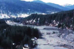
The mine spills in Romania in 2000 –
Lessons from and responses to the ecological disaster
Alexander Zinke: Zinke Environment Consulting for Central and Eastern Europe,       As this complex and sensitive issue has been addressed
Vienna, Austria; e-mail: Zinke.enviro@vienna.at
                                                                                by international organizations (ICPDR, UNDP, World Bank,
                                                                                UNEP) and NGOs (WWF, Greenpeace, IAD), both sites were re-
                                                                                paired and upgraded. However, regional inspections revealed
Risks of Mining
                                                                                many more potential risk sites across the entire Tisza and the
     Mining operations are often overexploiting natural                         wider Danube River Basins and the Balkan region (ZEC 2000,
resources; many mines are high risk areas and hotspots of                       2002; UNEP 2004; Peck & Zinke 2006).
pollution (soil, water, air). Mining accidents (pollution spills)
generally occur due to technical insufficiencies, bad manage-
                                                                                Causes of chronic and accidental pollution
ment and critical weather events, or a combination thereof.
Prevention is possible by applying high technical and en-                            The Tisza Basin is known to be rich in mineral resources
vironmental standards as well as precautionary measures but,                    (ferrous and nonferrous ores such as copper, lead, zinc, gold,
in fact, preparedness and alarm systems in most mines in SEE                    silver, bauxite, manganese, uranium and iron). Gold ores are
are still limited.                                                              concentrated in Transylvania, such as Rosia Montana (upper
                                                                                Aries catchment), and face a long history of mining since
                                                                                Roman times. The Apuseni and Banat Mountains are also
The mining accidents in 2000
                                                                                highly prospective for uranium (U-238) but many deposits are
    The Baia Mare and Baia Borsa (Romania) mine waste spills                    now depleted.
in early 2000 provide an illustrative example. They were
                                                                                    Mining legacies in the area are serious and extensive,
caused by the overtopping of dams after heavy rainfall on
                                                                                with risks of both national and transboundary pollution,
snow-covered tailings which was well documented (e.g. by
                                                                                damage of landscapes and deterioration of fauna and flora
UNEP-OCHA, US-EPA, IAD, VITUKI, NL-RIZA, WWF-DCP,
                                                                                habitats (UNEP 2004). Impacts include chronic and (potentially)
THW/GTZ). A major assessment was prepared by the "Baia
                                                                                acute environmental pollution. Besides background contami-
Mare Task Force" (BMTF 2000). The environmental impacts
                                                                                nation by heavy metals from natural rocks the continuous dis-
of both accidents can be summarized as follows:
                                                                                charge of heavily contaminated acid water from tailing ponds,
– Baia Mare: Some 100 000 m³ of wastewater conta-                               waste rock piles, and underground and waste dumps of aban-
  minated with heavy metal sludge and 120 tons of cyanide                       doned (inadequately closed) and operational (poorly managed)
  were released. While the Lower Tisza remained largely                         mining sites are the major sources of chronic pollution with
  unaffected due to the dilution and degradation of cyanide,                    hazardous substances in the Upper Tisza region (UNEP 2005;
  in the Upper and Middle Tisza massive losses in popu-                         Zobrist et al. 2008; Zinke 2010). Acid mine drainage (AMD)
  lations of fish (some 1242 tons), benthos (bottom fauna)                      results if non-ferrous metal deposits of copper, lead and zinc
  and plankton occurred. However, the ecosystem recovered                       sulfides are oxidized to sulfuric acid. Due to the low pH (1.5-
  rather rapidly, and even threatened or vulnerable species                     3.0) of these waters heavy metals can be leached from the
  such as the fish Burbot (Lota lota) and Pike-perch                            rock and mobilized. Consequently, heavy metals can enter and
  (Stizostedion lucioperca), the endemic mayfly (Palingenia                     bio-accumulate in the natural and human food chain.
  longicauda), the otter (Lutra lutra) and the White-tailed
                                                                                    Only in few cases contaminated mine waters are collected
  eagle (Haliaeetus albicilla) did not show long-term effects.
                                                                                and treated properly. The main reason is the lack of national
  Favourable conditions after the pollution event and the
                                                                                and international financial support for proper closure, decom-
  recruitment from unaffected tributaries and side arms have
                                                                                missioning and related modern waste water treatment (UNEP
  contributed to the re-colonisation (WWF 2002).
                                                                                2004). The political and economic changes after 1990 did not
– Baia Borsa: About 40 000 tons of solid waste and 100 000
                                                                                really improve bad mining practices (sub-standard extraction,
  m³ of water with high concentrations of heavy metals were
                                                                                processing and waste management; no proper aftercare and
  spilled. This accident received less public attention because
                                                                                monitoring). So, as in the past, many facilities pose risks with
  it occurred in a remote mountain valley (Figure 1) and its
  impacts were less spectacular. While peak concentrations                                                                    Figure 1. Baia Borsa-
  of heavy metals were measured in water and sediment (e.g.                                                                   Novat dam spill: view from
                                                                                                                              the dam downstream on
  0.86 mg/l Cu, and 2.9 mg/l Pb and Zn; IAD 2000), toxic
                                                                                                                              1 April 2000. The photo
  effects were limited and only few dead fish washed up on                                                                    reflects the significant
  foreign state river banks. However, as heavy metals accu-                                                                   local destruction of rive-
  mulate in sediments, may be re-mobilized and build up in                                                                    rine landscapes where
                                                                                                                              the various impacts on
  the food chain, long-term effects on the ecosystem can be                                                                   biota were hardly moni-
  significant but are hardly monitored in this mining region.                                                                 tored. Photo: A. Zinke

Page 8                                                                                                    Danube News – October 2012 – No. 26 - Volume 14
potentially wide impacts at limited public awareness, and ac- uted WRI, proving to be different from the national list and the
cidents are much less related to "force majeure" than to real site status (Zinke 2010). The weakness of these lists, fully
largely foreseeable technical failures. The few old waste water depending on provided national government information, was
treatment plants, operating with obsolete technologies, con- shown at the Ajka/Kolontár red mud accident spill in October
tinued to release large volumes of toxic substances into the 2010 in western Hungary whose risk was neither top-listed
streams. nor quantified, even though it was identified already in 2001.
The same refers to a probably even more dangerous site: the
In the Western Carpathians, uranium mine and mill ef-
Almásfüzitö red mud and hazardous waste dump right at the
fluents containing natural radioactive elements were often
Danube east of Komárom.
above permitted concentration. In 2000, the daily release of
radioactive effluents was about 14 000 m3 with average con- In 2004 the Environment and Security Initiative introduced
tent of 2–7 mg U/l. There is a serious problem of seepage an improved risk management of mining hotspots through its
from uranium tailings, which represent 6 million tons of accu- new guidelines ‘Mining for Closure’ (ENVSEC 2005). A follow-
mulated wastes at risk to contaminate soils and groundwater up workshop in March 2007 in Brestovacka Spa, Bor, Serbia,
by radio-nuclides (mainly Ra-226). Some accidental spills have addressed innovative, cost-efficient and robust mine water
occurred in the Tisza River Basin (e.g. in April 2000 at western treatment techniques (e.g. passive treatment) that rely on nat-
Romanian streams and then Fekete Körös River in Hungary), ural processes, such as bacterial activity and oxidation. These
but their causes and environmental/health impacts were hardly techniques, commonly used in North America, were recently
investigated (UNEP 2004). adopted in Western Europe and are suitable also for SEE. They
should be taken into consideration at all mining sites where
conventional techniques are not feasible due to financial and
Rehabilitation of mining sites
technical constraints. For related documents see http://www.
Beside a local workshop on accident prevention (water pol- envsec.org/index.php?option=com_content&view=article&id
lution) organized by the UNDP Country Office Romania in May =27&Itemid=52&lang=en®ion=SEE&type=publications
2000, a first regional inventory of potential Accidental Risk
It is hoped that such guidance is taken up and applied on
Spots (ARS), initiated by Romania and ICPDR, identified 139
time to prevent another ecological disaster of the mining
risk spots, including 42 at high risk (24 in RO, 11 in HU, 6 in
legacy. A scientific database on the transport paths and
UA and 1 in SK) with over 50% being tailing deposits (ZEC
depositing/accumulation patterns of pollutants in water and
2000). In follow-up steps, ICPDR developed until 2007 a com-
biological systems would help sustaining improved mining
mon methodology for ARS classification and ranking for the
management.
entire Danube Basin, including a Water Risk Index (WRI) as a
quantitative indicator also for flood risk areas. References
The Romanian mining company REMIN S.A., stimula- BMTF (2000): Report of the International Task Force for Assessing the Baia Mare
Accident. Brussels, December 2000. 40 pp
ted by Greenpeace and local authorities, identified priority ENVSEC (2005): Mining for Closure – Policies and Guidelines for Sustainable Mining
measures for 7 mining sites to reduce water pollution in the Practice and Closure of Mines. UNEP, UNDP, OSCE, NATO. 97 pp
upper Tisza River Basin and the impact risk on downstream IAD (2000): Participation of IAD-experts in the assessment of impacts on Szamos and
water users (in RO, HU and UA). Investments required ranged Tisza Rivers caused by accidental spills in Romanian mines. Danube News 2
Peck P, Zinke A (2006): Refined assessment of South Eastern European mining-related
from EUR 0.1 to 1 million per mining site (ZEC 2002). But only risks: Identification and verification of “environmental hot spots” in Albania, Bosnia
the listed Baia Borsa-Novat mine was repaired and upgraded & Herzegovina, Macedonia, Montenegro and Serbia. Report for a UNEP Vienna
with Austrian aid funds (Zinke 2005). coordinated ADA project. Draft doc. with 63 pp and annexes. See
http://www.envsec.org/see/index.php
With support from World Bank/GEF, the RO Government UNEP (2004): Rapid environmental assessment of the Tisza River Basin. 65 pp
UNEP (2005): Reducing Environment and Security Risks from Mining in South Eastern
agreed a closing strategy aiming from 2008 to 2020 at eco- Europe and the Tisza Basin. Final Report from the Sub-regional Conference of OSCE/
logical reconstruction and post-closure activities at 77 tailing UNEP/UNDP/NATO, 11-13 May 2005 in Cluj-Napoca, Romania
facilities, as part of a program addressing 550 mining objects. WWF (2002): The Ecological Effects of Mining Spills in the Tisza River System in 2000.
Vienna. 39 pp
But the national company CONVERSMIN stressed in 2010 that
Zinke A (2005): The Risk Mitigation – The Example of Rehabilitating the Baia Borsa-
only half of the needed budget was secured. So, although Nova Tailing Pond. p.19 in UNEP 2005
several sites in the Tisza region became less risky in recent Zinke A (2010): Background Paper on Accidental Pollution in the Tisza River Basin.
years, the overall situation remains critical. UNDP/GEF Integrated River Basin Management in the Tisza. Workshop Szolnok,
Hungary, April 2010. 16 pp
ZEC, Zinke Environment Consulting (2000): Regional Inventory of Potential Accidental
Risk Spots in the Tisa Catchment Area of Romania, Hungary, Ukraine & Slovakia
Lessons learned? (prepared for the ICPDR, Vienna). 48 pp and a colour A3 map
ZEC, Zinke Environment Consulting (2002): Assessment of Hot Spots on Industrial
More than 10 years after the disasters, the accident risk Pollution in the Upper Tisza Basin (Romania, Hungary): Impacts of Industrial Acti-
in many hot spots – particularly in the upper Tisza region – vities, Needs and Opportunities for Pollution Reduction. Prepared for Greenpeace,
was not effectively reduced. Main reasons are a low interest Vienna. Internal report. 62 pp
Zobrist J, Sima M, Dogaru D, Senila M (2008): EIMAR: Integrated Environmental and
among international donors, the local bureaucracy, and insuf- Socioeconomic Assessment of Impacts by Mining Activities in Western Carpathians,
ficient national updates and reviews of the ARS list and attrib- Romania. IAD Danube News 17: 6–7
Danube News – October 2012 – No. 26 - Volume 14 Page 9Tisza oxbows – restoration and aquatic macrophyte biodiversity
Georg A. Janauer: University of Vienna, Department of Limnology, Vienna, Austria;
e-mail: georg.janauer@univie.ac.at
Geza Jolánkai, Monika Mándoki: VITUKI Environmental and Water Management
Research Institute Non-Profit Public Utility Ltd. Liability Company, Budapest,
Hungary; e-mails: jolankai.geza@vituki.hu, mandoki.monika@vituki.hu
The origin and classification of oxbow lakes
Lowland rivers show a meandering course within the limits
of their natural floodplain, governed by hydrological proces-
ses and sediment properties. Erosive forces of floods along
the convex side of river bends shape these bends until new
short-cuts are created and the thalweg is shortened. Cut-off
meanders are called oxbow lakes. In the Hungarian lowlands Figure 1. Number of aquatic and amphibious plant species in Csatloi Holt
of the Danube and Tisza River corridors hundreds of natural Tisza. Numbers do not include helophytic species, which inhabit the bank
vegetation belt
oxbows were present until the second half of the 19th
century.
Navigation needs and flood protection measures led to dominant in five oxbows, and the two free-floating species
massive river regulation activities (“Széchenyi-Plan”; WR1 Duck Weed (Lemna minor) and Water Fern (Salvinia natans)
2012). Man-made short-cuts created artificial oxbows. Some dominated two oxbows.
were filled up with sediments, but most remained and are used
The present status of aquatic plant distribution in the 15
for fishing, as water reservoirs, and for recreation. A com-
oxbows is not published yet, but Csatloi Holt Tisza was studied
prehensive treatise on oxbow lakes lists 80 water bodies
frequently between 2002 and 2012. The drastic decline of
>4 ha along the Hungarian Tisza River corridor (Pálfai 2001),
macrophyte species (Figure 1) is correlated with a decreasing
while 138 oxbows with >5 ha were reported in 1992
connection period with the main Tisza channel. The progres-
(Mándoki, personal communication).
sive lowering of the water level in the oxbow during the last
Most ‘active’ oxbows are separated from the river during five years is mirrored by Tisza hydrographs. A similar loss of
low and mean discharge but connected during floods. Flood macrophytes may have occurred in other oxbows, too.
flow patterns determined by floodplain surface properties and
man-made structures (e.g. agricultural roads crossing the
Integrative solutions for oxbow restoration
course of oxbows) influence oxbow bed morphology, e.g.
creating deep pools. Oxbows situated outside the levees are The European Water Framework Directive requests –
connected to the river only by groundwater contact (Pall et al. amongst others – to achieve “good ecological status” for
1996; Molnár 2011). rivers. Ideally, river restoration shall enhance ecological quality
to historical, ‘near-natural’ conditions, including oxbows as
part of former river channels. However, reactivated water flow
Ecological importance, macrophyte vegetation
will ‘wash away’ the standing water community developed
and present status of Tisza oxbow lakes
over more than a century (Janauer et al. 2006), creating a
Oxbows are standing water habitats for most of the year, considerable conflict with the aims of the European Habitats
supporting an intensive development of aquatic plants Directive, the most important conservational legal instrument
(‘macrophytes’). Oxbows act as breeding and foraging habitats for EU member countries (WR2 2012). Present stakeholder
for aquatic animal life, especially fish and amphibians interests like fishing and recreation will also be affected. Water
(Schiemer et al. 2001; Dévai 2004). The macrophytes produce management strategies will need to bridge the gap between
biomass, but more important, provide structural elements in divergent EU legislation, sustainable new ways of flood control,
the water body like shoots and leaves, and protected habitats. drought mitigation and ecology-sensitive care for biological
Many aquatic plants are protected by law, underlining their diversity in the Tisza River corridor.
ecological value (Sârbu et al. 2011).
Two aspects beyond instant human control need to be
A survey of 15 Tisza oxbows (Janauer et al. 2006) revealed mentioned, too: temperature increase due to climate change
the importance of aquatic macrophytes for ecological and con- (DW Map 2012) and invasive plant species. Higher air tem-
servational status. While the floating-leaf plants White Waterlily peratures will not only increase Tisza River temperature but
(Nymphaea alba) and Water Chestnut (Trapa natans) were the also evapotranspiration and reduce summer discharge; hence,
most dominant species, the submersed Hornwort (Ceratophyl- due to lower water levels considerable areas in some oxbows
lum demersum) and Milfoil (Myriophyllum spicatum) were will dry out (Csatloi records, Mándoki, unpublished), anni-
Page 10 Danube News – October 2012 – No. 26 - Volume 14hilating most of the aquatic flora and fauna. Invasive species Hussner A (2012): Alien aquatic plant species in European countries. Weed Research
52: 297–306
are not only aliens (Hussner 2012); also native, dense Janauer GA, Jolánkai GG, Exler N (2006): River restoration in the Tisza River Basin:
canopies producing species have the potential of destroying conflicting interests and the future of the aquatic macrophyte vegetation. Archiv für
most of the aquatic biocoenosis: Water Chestnut and Water Hydrobiologie 158: 525–540
Molnár Z (2011): Landscape architecture in the Lower Tisza Valley: Classification of
Fern excessively compete against submersed plants and even Oxbow Lakes. Agriculture and Environment (Supplement 2011): 93–99
fish fauna (by depletion of oxygen under the canopy) in Csatloi Pálfai I (2001): Magyarország holtágai. Közlekedési és Vízügyi Minisztérium (Oxbow-
oxbow (Janauer, in preparation). As this regards protected lakes of Hungary. Ministry of Transport and Water Management), Budapest, 231 pp
Pall K, Rath B, Janauer GA (1996): Die Makrophyten in dynamischen und abgedämm-
species, too, future water management needs to be based on
ten Gewässersystemen der Kleinen Schüttinsel (Donau-Fluss-km 1848 bis 1806)
balanced integrated strategies considering the best solution in Ungarn. Limnologica 26: 105–115
for overall ecological enhancement. Sârbu A, Janauer GA, Schmidt-Mumm U, Filzmoser P, Smarandache D, Pascale G
(2011): Characterisation of the potamal Danube River and the Delta: connectivity
determines indicative macrophyte assemblages. Hydrobiologia 671: 75–93
References Schiemer F, Keckeis H, Winkler G, Flore L (2001): Large rivers: the relevance of ecotonal
structure and hydrological properties for the fish fauna. Archiv für Hydrobiologie
Dévai G (2004): State assessment of the oxbow-lakes. In: Pálfai I (ed), Presentations 135: 487–598
of the 2nd oxbow-lakes conference in Szeged. Ministry of Environment and Water WR1 (2012): http://en.wikipedia.org/wiki/István_Széchenyi (20120807; 09:00)
Management, Budapest, pp. 186–205 WR2 (2012): http://circa.europa.eu/Public/irc/env/wfd/library?l=framework_directive/
DW Map (2012): Annual and summer mean temperature changes in the Danube implementation_conventio/biodiversity_legislation&vm=detailed&sb=Title
Catchment 2021–2100. Danube Watch 1/2012, Map Supplement (20120808; 08:10)
Decapoda invasion along the River Tisza: current status and trends
Miklós Puky: Danube Research Institute, Centre for Ecological Research, plague (Vey et al. 1983), like other North American crayfish,
Hungarian Academy of Sciences, H-2131 Göd, Hungary; and it is present in at least 20 European countries today
e-mail: puk7949@mail.iif.hu
(Holdich et al. 2009). Its occurrence has recently been recog-
nised in Slovakia and Romania, and the River Danube played
Crayfish communities a key role in both cases, either as a source or as actual habi-
tat (Jansky & Kautman 2007; Pârvulescu et al. 2009; Puky
The loss of biodiversity is a key ecological process on
2009). Within Hungary O. limosus has only recently been
Earth threatening biota of different geographical units and
found in the River Tisza (Sallai & Puky 2008).
mankind as well (Rockström et al. 2009). Biological inva-
sions, i.e. the introduction of alien species, are one of the key
mechanisms of global environmental change, particularly in Mechanisms of spreading
freshwater ecosystems. Fish and crustaceans, for example,
Crayfish data were collected from the Hungarian stretch
are easily transferred for food, restocking and ornamental or
of the River Tisza, that is altogether 60.7 % of the total river
aquacultural purposes. These introduced organisms are often
length (966 km). Distribution and trends discussed are based
established in the wild by reaching high densities and greatly
on our own data and the literature published since the recor-
impacting native species or ecosystems (Light 2003). In
ding of this species from the River Tisza. O. limosus is pre-
Europe, the establishment of alien aquatic species is well
sent along the Hungarian stretch of the River Tisza (about
above the 5–20% suggested by Williamson's "tens" rule due
110 km) since the mid-2000s (Juhász et al. 2006; Sallai &
to multiple introductions, which indicates a higher than
average threat for inland waters of the continent (García-
Berthou et al. 2005).
Freshwater crayfish are important components of the Eu-
ropean aquatic fauna and can be considered as key species
in the habitat they colonised: being the biggest freshwater
macroinvertebrates, playing a crucial role as predators and
prey, and acting as ecosystem engineers (Souty-Grosset et
al. 2006). The spiny-cheek crayfish, Orconectes limosus
(Rafinesque, 1817; Figure 1), was the first non-indigenous
crayfish to be intentionally brought to Europe from the USA
(Holdich et al. 2009). After its introduction into Germany in
1890, secondary introductions were made into other parts
of Germany and into Poland and France, in an attempt to
make up for losses of the economically important noble cray-
fish, Astacus astacus (L.), through crayfish plague (Souty- Figure 1. Juvenile of Orconectes limosus with a typical blue coloration of the
Grosset et al. 2006). O. limosus acts as a vector of crayfish claws; total length = 3 cm. Photo: M. Puky
Danube News – October 2012 – No. 26 - Volume 14 Page 11Puky 2008). It was also detected in at least four tributaries References
and inflowing stream systems by 2011 (Szepesi & Harka García-Berthou E, Alcaraz C, Pou-Rovira Q, Zamora L, Coenders G, Feo C (2005): In-
2011). The populations of O. limosus in the middle of the troduction pathways and establishment rates of invasive aquatic species in Europe.
Hungarian Tisza stretch have no apparent direct contact with Canadian Journal of Fisheries and Aquatic Sciences 62(2): 453–463
Harka Á, Sallai Z, Szepesi Zs, Wilhelm S (2006): The spread of the Tubenose goby
those living in the Serbian section of the river. Besides (Proterorhinus marmoratus) and Monky goby (Neogobius fluviatilis) in the basin
gradually spreading over a large area, some populations also River Tisa and Central Europe. Acta Ichtiologica Romanica 1: 129–140
reach high densities (Müller et al. 2009 in Szepesi & Harka Holdich DM, Reynolds JD, Souty-Grosset C, Sibley PJ (2009): A review of the ever in-
creasing threat to European crayfish from non-indigenous crayfish species.
2011). Knowledge and Management of Aquatic Ecosystems 394–395: pp. 11/46./DOI:
10.1051/kmae/2009025
O. limosus rapidly colonised the Hungarian Danube Jansky V, Kautman J (2007): Americký rak Orconectes limosus (Crustacea: Decapoda:
stretch in the 1990s and early 2000s with an estimated Cambaridae) uz aj na Slovensku. Acta rerum naturalium Musei nationalis Slovenici
downstream speed of 13–16 km annually (Puky & Schád LIII: 21–25
Juhász P, Kovács K, Szabó T, Csipkés R, Kiss B, Müller Z (2006): Faunistical results of
2006). It was expected to reach the River Tisza from Serbia,
the Malacostraca investigations carried out in the frames of the ecological survey
through canals connecting the two rivers, or deliberate or ac- of the surface waters of Hungary (ECOSURV) in 2005. Folia Historico-naturalia Musei
cidental introductions. The present distribution pattern, i.e. Matraensis 30: 319–323
around Kisköre Reservoir – a dammed river section with a Light T (2003) Success and failure in a lotic crayfish invasion: the roles of hydrologic
variability and habitat alteration. Freshwater Biology 48: 1886-1897
large surface, suggests one of the last two alternatives. In- Müller Z, Kiss B, Juhász P, et al. (2009): A „Komplex Tisza-tó projekt” c. KEOP2.2.1/1F-
terestingly enough, such a colonisation pattern is not unique: 2008-003 pályázat keretében tervezett beavatkozások előzetes vizsgálati doku-
the Monkey goby, Neogobius fluviatilis, was also first found mentációja. Bioaqua Pro Kft., Debrecen. pp. 281
Pârvulescu L, Pálos C, Molnár M (2009): First record of the spiny-cheek crayfish Or-
in the reservoir in 1993, later in the River Tisza, then in tribu- conectes limosus (Rafinesque, 1817) (Crustacea: Decapoda: Cambaridae) in Ro-
taries (Harka et al. 2006), which may suggest a similar trans- mania. North-Western Journal of Zoology 5(2): 424–428
port mechanism, e.g. introduction with fish stocks from other Puky M (2009): Confirmation of the presence of the spiny-cheek crayfish Orconectes
limosus (Rafinesque, 1817) (Crustacea: Decapoda: Cambaridae) in Slovakia. North-
parts of the country. O. limosus, however, spread along the
Western Journal of Zoology 5(1): 214–217
River Tisza with a greater speed. Puky M., Schád P (2006): Orconectes limosus colonises new areas fast along the Da-
nube in Hungary. In: Gherardi F, Souty-Grosset C (eds): European crayfish as heritage
Other invasive Decapoda species across Europe, such as species - linking research and management strategies to conservation and socio-
Procambrius clarkii, or those present in the Carpathian Basin economic development. CRAYNET, Vol. 4. Bulletin Français de la Pêche et de la Pis-
(Pacifastacus leniusculus, Eriochier sinensis) are not expected ciculture 380-381: 919–925
Rockström J, Steffen W, Noone K, et al. (2009): A safe operating space for humanity.
to occur in the River Tisza in the near future, unless deliberate Nature 461: 472–475
introduction of P. leniusculus happens. At present their nearest Sallai Z, Puky M (2008): A cifrarák (Orconectes limosus) megjelenése a Közép-Tisza
populations inhabit the River Rába and its tributaries in the vidékén. Acta Biologica Debrecina Supplementum Oecologica Hungarica 18: 203–208
Souty-Grosset C, Holdich DM, Noël PY, Reynolds JD, Haffner P (eds) (2006): Atlas of
western part of Hungary. The catadromous E. sinensis, a rare crayfish species in Europe. (Patrimoines naturels, 64). Muséum national d’Histoire
species along the River Danube, is not expected to migrate to naturelle, Paris. pp. 187
the middle stretch of the River Tisza. However, O. limosus will Szepesi Zs, Harka Á (2011): Adatok a tízlábú rákok (Decapoda) magyarországi előfor-
spread rapidly along the River Tisza as well as in streams and dulásáról, különös tekintettel a cifrarák (Orconectes limosus) terjedésére. Folia Hi-
storico-naturalia Musei Matrensis 35: 15–20
canals in the Great Hungarian Plain, which may diminish na- Vey A, Söderhäll K, Ajaxon R (1983): Susceptibility of Orconectes limosus Raff. to cray-
tive Astacus populations fast in the region. fish plague. Freshwater Crayfish 5: 192–291
Cooperation in the Tisza River Basin –
achievements and future activities of the ICPDR Tisza Group
Diana Heilmann, Philip Weller, MIhaela Popovici: ICPDR, Vienna, Austria; Establishment of the ICPDR Tisza Group
e-mails: Diana.heilmann@unvienna.org, Philip.weller@unvienna.org,
Michaela.popovici@unvienna.org The Tisza countries have executed an agreement on
the protection of the Tisza and its tributaries in 1986 and es-
The ICPDR Tisza Group experts as well as observers from the five countries of the
Tisza River Basin have contributed to the development of the documents serving
tablished the Tisza Forum in 2000 to address flood issues.
as the basis of the present article They are all parties to the Danube River Protection Conven-
tion (DRPC) signed in Sofia in 1994, entered into force in
In the Tisza River Basin (TRB) there is a long history of 1998, the most comprehensive agreement for all Danube
cooperation. In 2004, in the frame of the ICPDR, the Tisza countries. In addition, all Tisza countries are parties to the
Group was established aiming to develop and facilitate Carpathian Convention, which was signed in Kyiv, Ukraine in
the implementation of an integrated Tisza River Basin 2003 and entered into force in 2006. The International Com-
Management Plan. mission for the Protection of the Danube River (ICPDR) is the
implementing body under the DRPC. Through the ICPDR, all
Contracting Parties support the implementation of the EU
Water Framework Directive (WFD) in their territories and
Page 12 Danube News – October 2012 – No. 26 - Volume 14You can also read