DETAILED PROJECT REPORT - MOEF
←
→
Page content transcription
If your browser does not render page correctly, please read the page content below

DETAILED PROJECT REPORT
                    ON
  MANAGEMENT OF ECOSYSTEM OF KAZIRANGA
NATIONAL PARK BY CREATING CLIMATE RESILIENT
  LIVELIHOOD FOR VULNERABLE COMMUNITIES
 THROUGH ORGANIC FARMING AND POND BASED
               PISCICULTURE
                    for
   NATIONAL ADAPTATION FUND ON
         CLIMATE CHANGE

                SUBMITTED
                   TO
   MINISTRY OF ENVIRONMENT, FOREST &
            CLIMATE CHANGE,
          GOVERNMENT OF INDIA
 Indira Paryavaran Bhavan, Jorbagh Road,
            New Delhi - 110003

                                        Page | 1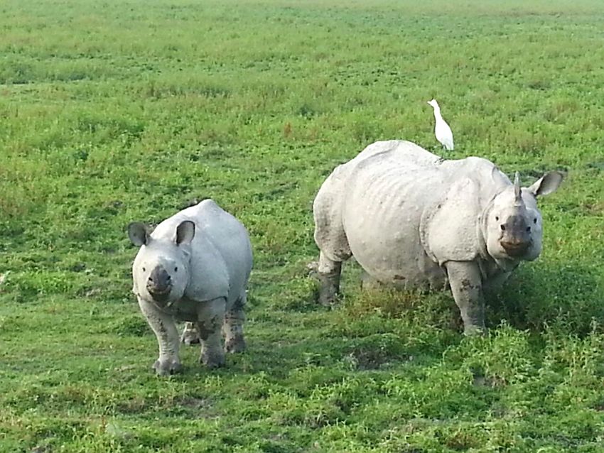
Title of Project/Programme: Management of ecosystem of Kaziranga
National Park by creating climate resilient livelihood for vulnerable
communities through organic farming and pond based pisciculture
Project/Programme Objective/s:
The proposed project entails the following broad objectives:
    ► Rejuvenating selected beels which are presently completely dry and doesn’t
       hold any water, which includes de-siltation of the beel to increase the depth
       and thus the augment the water holding capacity of the beel.

   ► Increase in livelihood option for vulnerable communities living in vicinity of
       Kaziranga National Park through organic farming and pond based fisheries
   ► Management of watersheds through check dams and ponds
Organic farming is envisaged for the vulnerable communities within the southern
periphery of the national park. A focused livelihood generation from fisheries is
also envisaged for the fishing communities living in the in the north bank of
Brahmaputra.
Project/ Programme Sector:
   ► Forestry, agriculture, fisheries and ecosystem

Name of Executing Entity/ies/Department:
  ► Kaziranga National Park (KNP) under Department of Environment & Forests
     (DoEF), Government of Assam.

Beneficiaries:
   ► Vulnerable communities living in the periphery of Kaziranga National Park
      (KNP), Assam

Project Duration: 3 years
Start Date: October 2016
End Date: September 2019
Amount of Financing Requested (INR.): 2,473.08 Lakhs
Project Location: The list of finalised project sites are as under.
North Bank: Tewaripal and Gorpal
South Bank: Rangalu, Difalu Pathar, Mohpara, Chepenakubua, No.1 and No. 2
Kohora EDC, Kuthori
State: Assam
District: - Kaziranga National Park lies partly in three districts namely Golaghat,
Nagaon and Sonitpur and borders Karbi Anglong district of Assam.The two civil
sub divisions namely Bokakhat and Kaliabor and two Police Stations namely
Bokakhat and Jakhlabandha control the whole civil area falling south of the Park
boundary. On the north, the civil jurisdiction belongs to the Tezpur Civil Sub-
Division, Biswanath Sub Division, and Gohpur Civil Sub-Division, and there are
seven Police Stations namely Gohpur, Helem, Behali, Gingia, Biswanath, Sootea
and Jamuguri on the northern side, and two Police Stations namely Bokakhat,
(with Kohora Outpost additionaly) in Golaghat district and Jakhlabandha (with
Kuthuri Outpost additionally) in Nagaon district. The Forest divisions of Golaghat,
Nagaon, Sonitpur East and West fall on the periphery of the Park.
Contact Details of Nodal Officer of the Executing Entity/ies/:
Director, Kaziranga National Park (KNP),
Department of Environment & Forests, Government of Assam,
Bokakhat, Golaghat District, Assam, PIN 785612 INDIA
Email: dir.knp@assam.gov.in
Mobile: Tel: 03715-295759

                                                                              Page | 2
1. PROJECT BACKGROUND

   1.1.        Project / Programme Background and Context:
   a) Provide    brief information    on   the           problem       the   proposed
      project/programme is aiming to solve
Background of Kaziranga National Park and its ecological importance:

The Kaziranga National Park is one of the oldest wildlife conservancy reserves of
India, first notified in 1905 and constituted as Reserved Forest in 1908 with an
area of 228.825 sq km specially established for conservation and protection of
the Greater One Horned Rhinoceros (Rhinoceros unicornis) whose number was
estimated at twenty pairs then. Kaziranga was declared a Game Sanctuary in
1916 and opened to visitors in 1938. It was declared a Wildlife Sanctuary in
1950, and notified as Kaziranga National Park in 1974 under the Assam National
Parks Act, 1968, with an area of 429.93 sq km. A series of additions namely 1st,
2nd, 3rd, 4th, 5th, and 6th Addition to Kaziranga National Park in several stages
were notified taking the total area to 884.43604 sq km. Kaziranga National Park
is famous for the Big Five namely the Rhinoceros (Rhinoceros unicornis), Royal
Bengal Tiger (Panthera tigris), Asian Elephant (Elephas maximas), Asiatic Wild
Buffalo (Bubalus arnee) and the Eastern Swamp Deer (Rucervus duvauceli
ranjitsinhii). It houses the largest population of the Greater One Horned
Rhinoceros in the world and houses about 68% of the entire world population. It
also has one of the highest densities of tigers in the wild in the world. It also
houses almost entire population of the Eastern Swamp Deer. Besides these big
five, Kaziranga supports immense floral and faunal biodiversity. It has 555 no. of
recorded plant species, 38 species of Mammalia of which 17 are endangered and
vulnerable, 553 species of avifauna of which 25 are globally important and 23
threatened, 42 species of Pisces, 17 species of fresh water turtles, 35 snake
species, 29 species of lizards and 24 species of Amphibia.

The Kaziranga National Park and its addition areas are spread over the three
districts of Assam namely Golaghat, Nagaon and Sonitpur, and form a
conservation complex with the Karbi Anglong Hills in the south. Kaziranga Karbi
Anglong complex is a notified Elephant Reserve known as Kaziranga Karbi
Anglong Elephant Reserve. The adjoining Hills of Karbi Anglong serve as natural
corridors and migration route for large mammals such as elephants, rhinoceros
and tigers. The hills of Karbi Anglong make the watershed for the rivers that feed
into Kaziranga National Park, noted among them being Difaloo river, Mori Difaloo
river, Mori Dhansiri river and Deopani river, all of which drain into the Kaziranga
National Park and its addition areas. The Kaziranga National Park has on its North
the mighty river Brahmaputra, entire stretch of which from Golaghat district
boundary on the east to the Kaliabhomora Bridge on the river on the west has
been constituted into the 6th Addition to Kaziranga National Park, contributing to
the already existing area of the park in the north bank.

Kaziranga has a very fragile ecosystem, where on one hand the annual flood
waters of the river Brahmaputra bring nourishment, leading to a very high
productive biomass, and on the other hand, the phenomenon of erosion takes
away lot of valuable and prime habitat. Kaziranga so far has lost more than 84 sq
km of its prime habitat to the river Brahmaputra. The 6th Addition supports a
huge population of local fish species and serves as a large natural hatchery for
downstream consumption. It also supports one of the largest Gangetic River
Dolphin populations. Since Kaziranga is a product of the complex geological and

                                                                                   Page | 3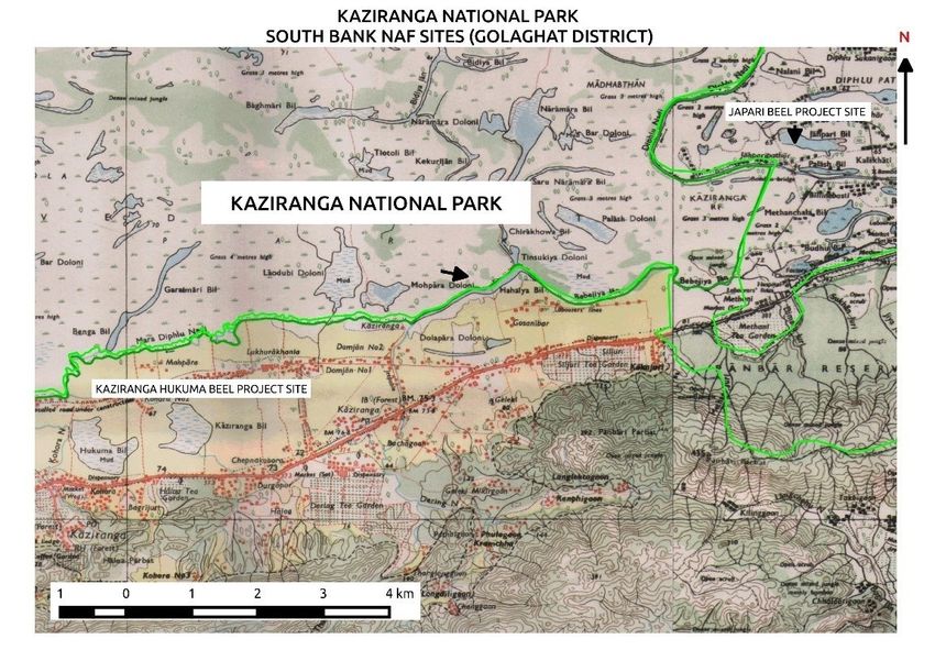
geomorphological dynamics of the river Brahmaputra and underlying tectonics,
the Kaziranga National Park is ecologically very sensitive to changes especially in
the upstream of the river Brahmaputra. The Kaziranga National Park has in its
vicinity several notified forest and protected areas namely Panbari RF and
Deopahar PRF in Golaghat district, Kukrakata Hill RF, Bagser RF, Kamakhya Hill
RF and Deosur Hill PRF in Nagaon district, Bhumuraguri RF in Sonitpur district,
North Karbi Anglong Proposed Wildlife Sanctuary in Karbi Anglong district; all
these reserved forests and protected areas not only have their own conservation
and biodiversity values, but also are of great ecological importance to the
Kaziranga National Park, serving as prime habitat and shelter for the migrating
wildlife of the Park.
The proposed project is envisaged on selected sites located in close vicinity of
Kaziranga National Park on the north bank and south bank of the Brahmaputra
river. A brief background and concerns of north bank and south bank sites are
discussed as under:
NORTH BANK: Since inception of Kaziranga in 1908, till the time the sixth
addition to KNP was conceptualised in 1999, the north of the Brahmaputra river
which lies north of Kaziranga was outside the Kaziranga National Park (KNP). The
people inhabiting the north bank have been traditionally fishing communities and
their main source of livelihood has been fishing with large boats in the
Brahmaputra River. As these areas were outside (as far removed as 10 to 15km
away from the park boundary) KNP, the park authorities never paid any attention
for developing community participation for conservation. The intervention of the
park authorities has mostly been in the form of raids and anti-poaching activities
in pursuit of suspected poachers which might be taking shelter in these areas.
However, after declaration of the Sixth Addition to Kaziranga National Park which
was done to minimize anthropogenic influence on the vulnerable ecosystem
already effected by climate change, since 2008, the entire area came under the
direct jurisdiction of the park authority. In 2010, a Range Office was established
in the northern range with head office in Biswanath and which has jurisdiction
over entire north bank. The forest department is contemplating strengthening of
jurisdiction further in the north bank by creating another Range Office by the
name of Northern Assam Range Division. Further, it needs to be mentioned that
the area of north bank right up to the NH 52, has been proposed to be
constituted into the Eco-Sensitive Zone of the Kaziranga National Park. The
proposal has already been sent by the Government of Assam (GoA) to the
Ministry of Environment Forest & Climate Change (MoEF&CC) for notification. All
the villages selected for this project fall within the Eco-Sensitive Zone of the KNP.
The park authorities off late are in the process of constituting Eco-Development
Committees (EDCs) in some of the areas sensitive to rhino poaching. The villages
proposed under this project under the north bank are the ones which are heavily
dependent on fishing and have high quotient of involvement of possible poaching
cases. It is expected, that once the right livelihood interventions are carried out,
this population would discontinue giving shelter to poachers and also stop illegal
fishing in the sixth addition areas of the park.
SOUTH BANK: In the past, adjoining forests of Karbi Anglong and grasslands of
KNP formed a single unit of sparsely populated area. However, with the opening
of southern side of the National Highway No. 37 the forest-cover diminished and
got fragmented resulting in loss of natural wild habitat. The southern bank also
saw establishment of tea gardens as early as 1870s. Following these

                                                                               Page | 4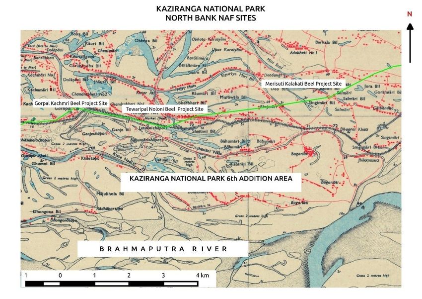
establishments, human habitation and agricultural activities started multiplying
in manifolds in the southern bank on the fringes of the constituted Kaziranga
National Park. The situation has only worsened over time with the changing land
use pattern and widening of the gap between the Park and the hills by human
settlements, affecting the movement of wildlife from grasslands to highlands in
the south of the park during floods and otherwise. The wildlife confined in the
grasslands during floods fall easy prey to the poachers.
Further, the southern part of Nagaon district in central Assam valley and
adjoining parts of Karbi Anglong form a rain-shadow zone where annual rainfall is
as low as 800-1200 mm. Water scarcity is a constraint for the people living in this
rain shadow zone and absence of effective irrigation system or water harvesting
practices has limited the yield from agricultural land. As the population is
primarily agrarian, this adds on to their vulnerability to climate change. Through
this project, surface water sources will be rejuvenated which will reduce pressure
on the limited ground water resources, improve hydrological balance of the
ecosystem, reduce flood intensity in surrounding areas, and provide with
improved opportunity for adapting multi-cropping practices.
   b) Outline the economic, social development and climate change in line
      with the State Action plan on Climate Change and relevant Missions
      under National Action Plan on Climate Change

Impact of climate change on economic development of Assam:
Assam’s economy is still agrarian as seen from the fact that 86% of its rural
population is dependent on agriculture and allied activities such as agriculture,
fisheries and forests, which together contribute 34% of the GSDP. Agriculture in
Assam is a water intensive sector given that 81% of the water withdrawn from
the available sources is for irrigation. Due to climate change, decrease in annual
rainfall and increased extreme rainfall events have caused flash floods, severely
impacting agricultural production. High run offs during these extreme rainfall
events also cause siltation in surface water bodies thereby reducing their water
holding capacity. Further, flash floods also affect the rate of ground water
recharge, hence affecting access to potable water. Based on estimates made by
Government of Assam, the state loses 80000 hectares of fertile land every year
during flood.1 This has a huge impact on the Assam’s GSDP.
The proposed initiative (under National Adaptation Fund) aims to rejuvenate
available surface water bodies to develop fisheries and practice climate resilient
agriculture, in-sync with the economic requirement of Assam (As per the SAPCC).

Impact of climate change on social development of Assam:
As per the State Action Plan on Climate Change (SAPCC), in 2011-12, as 31.98%
of the State’s population lived below the poverty line against all India average of
21.92%, with majority of the population, especially the people living in interior
rural areas, in areas inhabited by Scheduled Caste & Scheduled Tribe population,

1 http://www.ndtv.com/india-news/gone-in-the-assam-floods-8-000-hectares-of-fertile-land-every-
year-1217667

                                                                                           Page | 5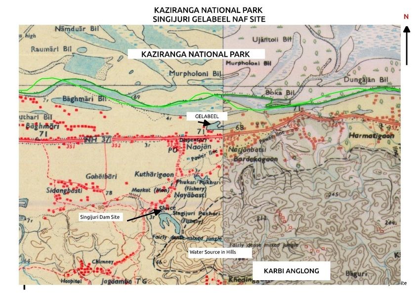
tea garden areas and far flung “char” (riverine) lack facilities of safe drinking
water, sanitation etc.
A Socio-economic survey of the existing 33 EDC (Eco Development Committee)
villages in KNP by WWF indicates that 85% of the families living in these EDCs
are marginal and landless. These communities have limited capacity to adapt to
climate change related vulnerability. Many families in these EDCs lack minimal
facilities like safe drinking water, sanitation, health facilities. These
developmental gaps and lack of socio economic infrastructure are common to
the communities vulnerable to climate change. 2

Relevance to State Action plan on Climate Change and Missions under
National Action Plan on Climate Change
This project is aligned with the Assam’s State Action Plan on Climate Change
(SAPCC) and Missions under National Action Plan on Climate Change. The
following points illustrates the actions proposed by state and national programs
to address the development as well as climate risk related to water, forestry,
fisheries, wildlife and agriculture.

SAPCC:
The SAPCC of Assam identifies ensuring sustainability of agriculture systems as a
major concerns related to sustainability of critical ecosystems including agro-
ecosystems (agriculture, fishery, and livestock) to ensure livelihood security in
a changing climate scenario. The following section of the SAPCC will be relevant
to the proposed project:

Forests and Biodiversity
Like rest of the North Eastern region of India, Assam is blessed with forest/ tree
cover. Together with tree cover outside the forests, the total green cover in
Assam extends over an area of 253 sq. km which is 37.29% of the total
geographical area of the State. Apart from providing a variety of products for
daily needs, such as, firewood, fodders, medicinal plants, bamboos, fruits,
essential oils and so on, the forest also are the recharge zone of rain water in the
spring sheds in the mountain areas. Further, they also provide livelihood
opportunities to over a million people in the State, who trade in various timber
and non-timber products. However, open forests in the State in 2013, as
recorded by the FSI covered 51% (14,882 sq. km) of the total green cover of the
State and very dense forests were only 5% of the green cover (see Figure 14).
This is because the forest area is suffering from habitat degradation,
encroachments, fuel wood extraction etc.

22Detailed report on issues and Possible Solutions for Long Term Protection of the Greater One
Horned Rhinoceros in Kaziranga National Park. Pursuant to the Order of The Hon'ble Guwahati High
Court

                                                                                         Page | 6
The forests here experience extreme rainfall and extended dry periods and, thus
sustainable watershed management is a need within the forest areas of Assam.
The concerns are elaborated in the SAPCC as follows:

   ► Extreme Rainfall in Hilly areas: Extreme rain fall events are likely to
     lead to heavier run off along the hills, thus the potential ground water
     recharge in the spring sheds is likely to reduce, along with heavy soil
     erosion.
   ► Longer Dry periods: With longer drought periods, biodiversity- both
     floral and faunal are likely to be affected and forest fires may become the
     norm, with increasing man-animal conflict. Thus affecting the various
     types of timber and NTFP produce and hence the livelihood of the people
     dependent on the same.

Strategies for sustainability of agriculture and horticulture systems:
   ► Assessing District wise exposure and vulnerability of agriculture systems to
      climate variability and change and developing climate smart Adaptation
      Strategies through Stakeholder consultation for all 27 districts taking into
      consideration the agro-climatic zone in which they are located
   ► Establishing demonstrative integrated farming systems by introducing
      agro-forestry and agro pastoral practices
   ► Restore natural water bodies to conserve run off and reduce likelihood of
      catastrophic flooding
   ► Sustainable eco-friendly horticulture in hilly areas which will reduce run off
      and soil erosion in the hills, thereby checking siltation and drying up of
      spring sheds

Strategies for sustaining fish production in Assam in a changing climate
context
   ► Backyard fisheries in small tanks in same area where water use efficiency
      will be piloted in agriculture
   ► Reclamation of ponds and beels wherever possible, to convert them into
      fisheries and for using them as a source to meet demand for water in the
      dry season.

The Wildlife Management Plan called the Tiger Conservation Plan of Kaziranga
Tiger Reserve has been prepared in two parts namely Core and Buffer. While the
core plan deals with the core areas of the Kaziranga Tiger Reserve, namely the
Kaziranga National Park and its various additions (1,2,3 & 5), wherein habitat
improvement is a recommended agenda. The Buffer Plan covers the areas of the
buffer and the fringe villages for whom a Microplan based development initiative
has been envisaged. All the prject villagesuner this scheme shall have a
Microplan in collaboration with civil society organisations and community
members which being strategized for combating poaching, securing identified
animal corridors, reducing human-animal conflict, sustaining conservation
initiatives and public sensitization on conservation animal habitats and corridors.

                                                                             Page | 7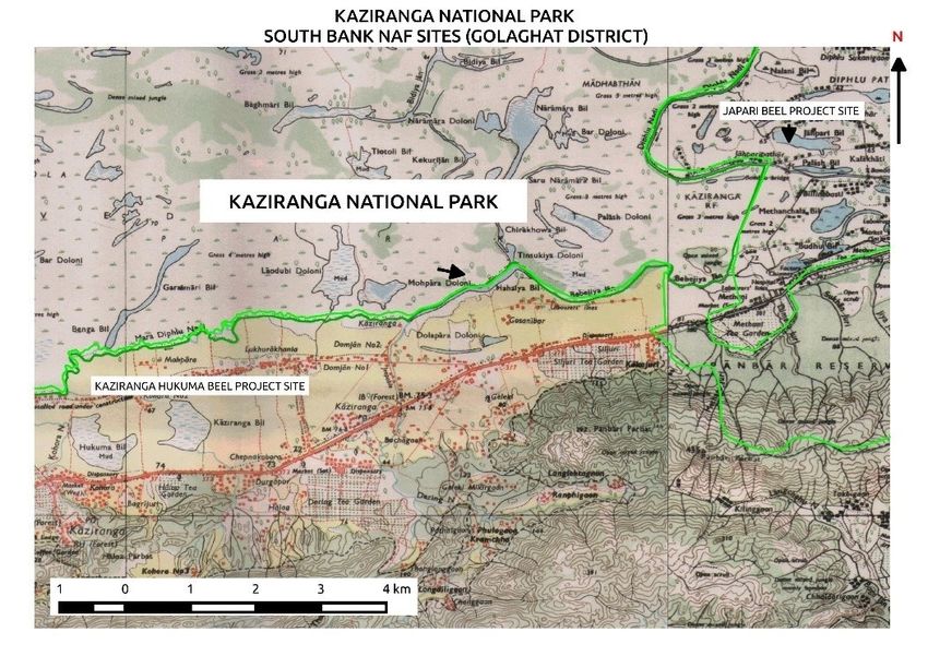
Natural Disturbance Model Habitat Management will be used to plan
activities for conserving animal habitats. This entails identification of a natural
disturbance condition in the surrounding of the park that resembles the human
disturbance followed by quantification of the vegetation in the naturally
disturbed area. The data gathered is used to build a model for revegetation and
is also used as reference to evaluate the success of introduced restoration
treatments and recommended improvisations.

National Missions:
         ► One of the key thrust areas to be addressed under the National
           Mission for Sustainable Agriculture (NMSA) includes dryland
           agriculture. The NAPCC also mentions one of its objectives as to
           devise strategies to make Indian agriculture more resilient to
           climate change by focusing on improving the productivity of rain fed
           agriculture. Aligned with the same objective is Paramparagat
           Krishi Vikas Yojna, which is an elaborated component of Soil
           Health Management (SHM) under NMSA. Under PKVY Organic
           farming will be promoted through adoption of organic village by
           cluster approach and Participatory Guarantee System (PGS)
           certification. Fifty or more farmers will be motivated to form a
           cluster having at least 50 acres of land to take up organic farming
           under the scheme. This scheme promotes commercial organic
           production and will link the produce with the market, raising
           farmer’s income and creating potential market for traders. The
           project components relate to the three main dimensions targeted by
           NAMSA and these are- ‘Water use efficiency’, ‘Nutrient
           Management’ and ‘Livelihood diversification’. The project objective
           agrees to the mandate of progressively shifting towards
           environment friendly technologies through the components like
           vermicomposting under the organic agriculture activity. Also, the
           project components of rejuvenating surface waterbodies will also
           indirectly relate to NAMSA objective for achieving “More crop per
           drop”. Further, project also links with the Sub-Mission on Agro-
           Forestry (SMAF) under NAMSA. Based on the field survey, trees like
           Phyllanthus emblica (Amla), Artocarpus heterophyllus (Jackfruit),
           Citrus limon (Assam lemon), Areca catechu (Betel nut) and high
           yielding climbers like Piper nigrum (Black pepper).

   ► National Water Mission seeks to develop new regulatory structures,
     combined with appropriate entitlements and pricing. It will seek to
     optimize the efficiency of existing irrigation systems, including
     rehabilitation of systems that have been run down and also expand
     irrigation, where feasible, with special effort to increase storage capacity.
     Incentive structures will be designed to promote water-positive
     technologies, recharging of underground water sources and adoption of
     large scale irrigation programmes which rely on drip irrigation and ridge

                                                                             Page | 8
and furrow irrigation. Efficient usage of water ensures less exploitation of
        water resources available in drought affected regions of Assam and will
        help drought management. If water usage can be optimized through
        efficient agricultural practices and irrigation system, the additional water
        available can be utilized for additional area by more marginal farmers. This
        will help improve social equity.

    ► National Mission on Sustaining Himalayan Ecosystem recognises
      importance of scientific and technical inputs required for sustaining the
      fragile Himalayan Ecosystem. In line with the same, State Knowledge Cells
      will be established under the mission which will address action of laying
      out sector specific and cross-sectoral time bound priorities which are –
      building human and knowledge capacities; building institutional capacities;
      building capacities for evidence-based policy implementation; and building
      capacities for continuous learning and proactive designing of development
      strategies. This cell provides scope for enhanced institutional functioning,
      aiding in effective implementation of strategies and documentation of
      success and challenges. This will consequently build ground better
      planning and implementation of activities, thereby contributing in building
      climate resilience of the habitat and communities.

    ► This is with reference3 to Mahatma Gandhi NREGA and Agriculture
      convergence        guidelines    issued      in     2009       (Available   on
      www.mgnrega.nic.in under the icon "convergence"). Rural poor are most
      vulnerable to climate change, as their livelihood is directly dependent on
      environmental resources. As extreme events increase, the potentiality of
      longer and more severe drought, and increased water stress would be
      greater. These will have an adverse impact on agriculture, water sources,
      forest and coastal areas. Several studies have indicated that, as the
      surface temperature of earth rises, climate change will reduce crop
      productivity; this will be more pronounced in rain fed areas, and would
      further increase the vulnerability often the rural poor. A study on
      Environmental Benefits and Climate Change Vulnerability Reduction
      through MGNREGA has been conducted by Indian Institute of Science (IISc,
      Bangalore) and GIZ across 5 states, Rajasthan, Madhya Pradesh, Andhra
      Pradesh, Karnataka, Sikkim. The study showed that wherever MGNREGA is
      being implemented effectively it is generating multiple environmental
      benefits, leading to improved water availability, soil fertility and increased
      crop production. MGNREGA works are also helping reduce soil erosion and
      increase area under plantations. Overall the study concludes that
      MGNREGA works have contributed to improving the adaptive capacity of
      rural people and reducing their vulnerability to climate risks.

33 http://nrega.nic.in/netnrega/convergence/%5Cwritereaddata%5CConvergence%5Ccirculars
%5CConvergence_Prog_Min_Agriculture.pdf

                                                                                         Page | 9
c) Include climate analysis and vulnerability analysis.

Climate analysis
Earlier studies indicate that over the last few million years, the strength of the
Asian monsoon has often varied in response to changing global processes 4. There
is therefore every possibility that current and predicted changes in climate and
precipitation will have impacts on the Brahmaputra River. Research suggests that
the types of environmental changes predicted in climatic models are already
taking place. Studies on many animals and plants that show significant
alterations in range or behaviour that is not due to direct pressure from humans
find that climate change is the most consistent explanation 5. Studies in other
parts of India such as Gujarat6 and the Western Ghats7 suggest that changes in
species will soon or are already taking place as a result of climate change, even
within protected areas.
Given the extent to which the ecology of Kaziranga is dependent on the
variations in annual river flow, climate-induced changes could have a major
effect on the park’s ability to maintain biodiversity over time. Firm evidence of a
long-term regional trend in area-averaged precipitation for Asia has yet to be
found8. However, various models have been developed to predict the possible
effects of climate change on the climate the region. Although the results differ in
extent, all agree that an increase in water levels and thus possibly also of
flooding is likely. One atmosphere-ocean-land model suggests that the Ganga-
Brahmaputra discharge could increase by as much as 49 percent, due to an
increase in the absolute humidity of air and the intensification of the South Asian
monsoon circulation9. A climate change scenario using UKTR results (a high
resolution transient climate change experiment carried out by the Hadley Centre
in the UK) show the peak discharge of the Brahmaputra increasing by 13 percent
following a 60C global mean temperature rise 10.

4    4
      Kale, VS, Gupta A & Singhvi AK 2004, ‘Late Pleistocene-Holocene Palaeohydrology of Monsoon Asia’,
     Journal of the Geological Society of India, vol. 64, no. 4, pp. 403-418.

5    5
      Santer, BD, Wigley, TML, Barnett, TP & Anyamba E 1996, ‘Detection of climate change and attribution of
     causes’, in Houghton, JT, Meira, LG, Filho, Callander, BA, Harris, N, Kattenberg, A & Maskell, K (ed.s) Climate
     Change 1995: The Science of Climate Change. Contribution of Working Group I to the Second Assessment
     Report of the Intergovernmental Panel on Climate Change, Cambridge University Press,Cambridge, UK and
     New York.

6    6
     Clark, B & Duncan, P 1992, ‘Asian wild asses—hemiones and kiangs’, in Zebra, Asses and Horses: An
     Action Plan for the Conservation of Wild Equids, The World Conservation Union (IUCN), Gland, Switzerland.

7    7
     Katti, M & Price, T 1996, ‘Effects of climate on palearctic warblers over wintering in India’, Journal of the
     Bombay Natural History Society, vol 93, pp. 411-427

8    8
     Mirza, MMQ, Warrick, RA, Ericksen, NJ & Kenny, GJ 2001, ‘Are floods getting worse in the Ganges,
     Brahmaputra and Meghna basins?’ Environmental Hazards, vol 3, no.2, pp. 37–48

9    9
     Manabe, S, Milly, PCD & Wetherald, R 2004, ‘Simulated long-term changes in river discharge and soil
     moisture due to global warming’ Hydrological Sciences, vol. 49, no. 4, pp. 625-642

10   10
      Mirza, MMQ, Warrick, RA, & Ericksen, NJ 2003, The Implications of Climate Change on Floods of the
     Ganges, Brahmaputra and Meghna Rivers in Bangladesh, Climatic Change, vol. 57, no. 3, pp. 287-31

                                                                                                           Page | 10
The State Action Plan on Climate Change (SAPCC) for Assam acknowledges the
climate related issues impacting water availability. As per the SAPCC, State level
climate data for the period 1951 to 2010 has been analysed by the India
Meteorological department11. In Assam, the analysis is based on data collected
from 6 Stations for temperature and 12 Stations for rainfall. The analysis
indicates that the mean temperature in the State has increased by +0.010C/year.
There is also an increase in seasonal temperatures across seasons with
pronounced warming in post monsoon and winter temperatures. The annual
rainfall has also decreased by -2.96 mm/years during the same period.
Table 1: Climate trends in Assam between 1951 and 2010
During the same period, the average annual rainy days have decreased by 1.61,
0.58 and 0.14 days in the project districts of Golaghat, Nogaon and Sonitpur
respectively. In 2004, Sonitpur also encountered two devastating floods
impacting flora, fauna and human habitat in this region 12. Decrease in rainfall and
extreme flash floods adversely affect ground water recharging. The same is
elaborated under section 1.b.
As per the SAPCC the current practices such as over exploitation of ground water,
Jhum cultivation in hilly (practiced in southern part of KNP) areas, mono cropping
etc. and recurrent floods and droughts are putting pressure on the agriculture
system. Exacerbation of climate change induced hazards are likely to further
make the agriculture production system of the State uncertain, and these issues
need to be addressed within the developmental plans of the State.
If current trend continues, climate change will negatively impact the water
resources sector by increasing freshwater scarcity, which is already a problem for
Assam in the summer. The predicted increase in average temperature and
decrease in the number of rainy days due to climate change will further stress
water resources. This problem is compounded by high levels of groundwater
11 11
Rathore L S, A D Attri and A K Jaswal, 2013. State Level Climate Change Trends in India. Meteorological
Monograph No. ESSO/IMD/EMRC/02/2013. India Meteorological Department. Ministry of Earth Sciences. GoI
12 12State Action Plan on Climate Change, Assam
Page | 11extraction, which can be expected to continue given Assam’s growing population
and reliance on agriculture.
Kaziranga benefits the downstream populations living along the river
Brahmaputra by serving as an extensive nursery/ hatchery for fishery and other
aquatic flora and fauna. Its almost 300 waterbodies, rivulets and streams capture
more than 1000 McuM water during floods, thereby acting as flood cushion. If
properly maintained and conserved, these natural landscape has sufficient
potential to reduce the probabilities of catastrophic flood events, under a
possible climate change extreme scenario. On the other hand, the watershed of
the national park has a network of thousands of streamlets which if not
preserved and improved can have potentially hazardous outcome for the
populations residing in the foothills and valley areas as well as can spell
irrecoverable disaster for the ecosystems of the Kaziranga National Park. The
approximate area of the watershed, excluding the Kukrakata RF, and Panbari RF,
comes to 750 sq. km, of which approximately 515 sq. km falls in Karbi Anglong.
The watershed area pertaining to Golaghat is about 125 sq. km and the rest falls
in Nagaon district, amounting to 110 sq. km. It has been seen that this
watershed has about 3000 1st order streams, 670 2nd order streams, 145 3rd
order streams, 30 4th order streams, 8 no.s 5th order streams and 2 no.s 6th
order stream (which is same as that of the river Brahmaputra). The mean
stream-length is 0.62 km, stream frequency per sq km is 5.00, drainage density
is 3 km per sq. km, drainage texture is 16.36, texture ratio is 12.62 and
circulatory ratio is 0.18 for this watershed. Restoration, preservation and
maintenance of these ecosystem services are of utmost importance as a whole
and in particular, to address the possible outcomes of climate anomalies.
An analysis of annual average rainfall, average maximum and minimum
temperature data collected from two tea-gardens located in the southern and
northern bank of Brahmaputra, which are adjacent to the Kaziranga National Park
area is presented as under –
Average Rainfall in Sakomato TE, North Bank (in inches)
10.00
9.00
8.00
7.00
6.00
5.00
4.00
3.00
2.00
1.00
0.00
1986 1990 1994 1998 2002 2006 2010 2014 2018
1984 1988 1992 1996 2000 2004 2008 2012 2016
Fig 1: Average annual rainfall (inches), Sakomato TE, North Bank
Page | 12Average Maximum Temperature, Pratapgarh TE, North Bank (0C)
36
35.5
35
34.5
34
33.5
33
2004 2006 2008 2010 2012 2014 2016
Fig 2: Average Maximum Temperature, (0C) Pratapgarh TE, North Bank
Average Minimum Temperature, Pratapgarh TE, North Bank (0C)
20
18
16
14
12
10
8
6
4
2
0
2004 2006 2008 2010 2012 2014 2016
Fig 3: Average Minimum Temperature, (0C) Pratapgarh TE, North Bank
Average Rainfall, Pratapgarh TE, North Bank(in Centimeter)
250
200
150
100
50
0
2003 2004 2005 2006 2007 2008 2009 2010 2011 2012 2013 2014 2015
Fig 4: Average Annual Rainfall (cm) Pratapgarh TE, North Bank
Page | 13The available data shows a declining trend for rainfall in these locations, while
increasing trend was observed for annual maximum and minimum temperature.
The available annual average rainfall data for Golaghat district 13 also shows a
declining trend. However, amount of data available is limited to conclude about
the significance of the observed trend.
Annual Average Rainfall, Golaghat District, South Bank (Centimetre)
200
180
160
140
120
100
80
60
40
20
0
2003 2004 2005 2006 2007 2008 2009 2010 2011 2012
Fig 5: Annual Average Rainfall (cm), Golaghat District, South Bank
Vulnerability related challenges Faced by the Fringe Village
Communities around Kaziranga National Park
As can be seen from the field survey, most communities are very poor, landless
and have little or no means of survival. Some of the key vulnerability challenges
faced by them are: -
1. Around 85% families are daily wage earners, livelihood options are very
limited. Hence, most of the villagers are small or marginal farmers and are
subject to climate related vulnerabilities like drought and floods.
2. Loss of agricultural land and livelihood due to wild animal depredation.
Around 278 hectares of agricultural land is rendered unfit for agriculture
due to depredation by wild boar and wild elephant. Due to climate impacts
like draughts and flash floods, the animals leave their natural habitat and
venture inside the agricultural area (in search of food).
3. Loss of livelihood due to non-availability of Grazing land for Livestock
population: Sixth addition of Kaziranga National Park has led to loss of
traditional grazing fields inside Panpur RF and Char areas.
4. Loss of Livelihood due to extinguishing of fishing rights inside Sixth
addition of Kaziranga National Park. Those villagers who were traditional
fishermen have lost their livelihood. This was done to minimize
anthropogenic influence on the vulnerable ecosystem already effected by
climate change. However, the scope of collection of water in natural ponds
and beels for fishery projects is limited. If the livelihood concerns of the
fishing communities are addressed sustainably, this will also help reducing
the population pressure on the natural resources of the park area.
13 www.indiawaterportal.org/sites/...org/.../imd_district-wise_rainfalldata_2004-2010.xls
Page | 145. Again, the southern part of Nagaon district in central Assam valley and
adjoining parts of Karbi Anglong form a rain-shadow zone where annual
rainfall is as low as 800-1200 mm. Water scarcities are a potential
constraint for the people living in this rain shadow zone and absence of
effective irrigation systems or water harvesting practices adds to the
vulnerability of the people. Limited agricultural yield from land in southern
part of the national park due to inadequate availability of water.
6. Limited or no access to clean drinking water, power and LPG. The
populations living in the watershed areas, Bagser RF and Kukrakata RF
have virtually no access to clean drinking water. They have to depend
solely upon stream water which appears to be highly impacted by possible
climate change impacts. According to the inhabitants of these areas, not
only quantum, but also quality of water has considerably reduced from
these streams. The level of arsenic and fluoride in the ground water has
started making its present felt in some of the areas.
7. Lack of amenities such as school, hospital, veterinary centre.
8. Increasing human animal interface due to encroachment by human and
spill over of forest animals into the adjoining villages.
d) Project Location details – villages, block/ mandal, district
The sites of the pilot project were identified through an initial survey and
consultation with local community and state government officials.
Project Sites:
North bank:
a. Gorpal
b. Tewaripal
South bank:
a. Kaziranga Hukuma
b. Kunjuri-Gelabeel
c. Amguri Chang and Phulaguri Chang
d. Japori Beel
District: - Kaziranga National Park lies partly in three districts namely
Golaghat, Nagaon and Sonitpur and borders Karbi Anglong district of Assam.
Page | 15Fig 6: Satellite map of Kaziranga National Park (KNP)
Fig 7: Land use within KNP
e) Demographic details of the population – total population (for area in
operation), sex- disintegrated data, etc.
NORTH BANK:
The demographic profile for the villages selected from the North Bank of
Brahmaputra is given below:
a. Gorpal
No of Total Total Male Total Female
Household Population
280 1481 750 731
Page | 16b. Tewaripal (Naloni & Merisuti Beel)
No of Total Total Male Total Female
Household Population
283 1568 805 763
SOUTH BANK:
The demographic profile for the villages selected from the South Bank of
Brahmaputra is given below:
a. Kaziranga & Hukuma
No of Total Total Male Total Female
Household Population
946 4461 2351 2110
b. Kunjuri-Gelabeel
No of Total Total Male Total Female
Household Population
316 1480 790 690
c. Amguri Chang and Phulaguri Chang
No of Total Total Male Total Female
Household Population
258 695 410 285
d. Japori Beel
No of Total Total Male Total Female
Household Population
108 364 195 169
Total Beneficiaries (Direct & Indirect):
Site Total Beneficiaries (No. of
families)
Gorpal 280
Tewaripal 293
Kaziranga- 400
Hukuma
Kunjuri-Gelabeel 1000
Amguri-Phuloguri 284
Japori 108
Page | 171.2. Project/ program objective
The proposed project entails the following broad objectives:
► Rejuvenating selected beels which are presently completely dry and
doesn’t hold any water, which includes de-siltation of the beel to increase
the depth and thus the augment the water holding capacity of the beel.
This will help in reducing the intensities of flood as well as provide options
for managing and tackling drought conditions under a possible climate
change scenario.
► Increase in livelihood options for vulnerable communities living with the
vicinity of Kaziranga National Park through organic farming and pond
based fisheries. Organic farming increases the climate resilience potential
of agricultural sector by banking on integrated crop management
techniques, which include time-tested indigenous technological know-how
of the farming communities, increased capacity of the soils to hold more
moisture, more nutrients and drain better, thereby increasing the potential
of organically replenished soils to adapt better in climate extremes like
drought, vagaries of rainfall, floods etc. Further, being a more diverse
system of cropping, with focus on local crops/varieties, organic agriculture
provides better option for climate contingent farming 14. Similarly, fishery is
an activity that can provide two benefits simultaneously-direct livelihood
option as well as facilitating water regime rejuvenation in the nearby
areas, thus making cropping practices more resilient to water stresses that
may occur from climate catastrophes.
► Management of watersheds through check dams and ponds to restore and
maintain hydrological balance of the ecosystem, to build its resilience
towards climate change affects.
1.3. Details of program/ project executing agency
a) Name, Registration No. & Date, Registered Address, Project Office
Address (for the proposed project)
The Department of Forestry, Government of Assam will be project executing
agency. The nodal office which will be responsible for the current project is:
Director, Kaziranga National Park (KNP),
Department of Environment & Forests, Government of Assam,
Bokakhat, Golaghat District, Assam, PIN 785612 INDIA
b) Available technical manpower for the proposed project implementation:
The KNP is a part of Eastern Assam Wildlife Division is headed by a Divisional
Forest Officer (DFO). He is assisted by three Assistant Conservators of Forest
(ACF). A Wildlife Research Officer (WLRO) is also posted in Kaziranga who
14 Technical paper on Organic Farming and Climate Change,
http://www.intracen.org/uploadedFiles/intracenorg/Content/Exporters/Sectors/Fair_trade_and_enviro
nmental_exports/Climate_change/Organic_Farming_Climate_Change.pdf
Page | 18assist the DFO in all the research related matter. The Division is divided into
five Ranges which are looked after by the Forest Range Officer (FRO). The
FROs are assisted by Dy FRO, Forester -I, Forester-II, Forest Guards, and other
field staffs. The overall control of the Park is looked after by the Director who
is a Chief Conservator of Forests (CCF) level Officer. He is assisted by a
Conservator of Forests (CF) and three Deputy Conservator of Forests (DCF).
The total sanctioned strength in Kaziranga is 562 at Divisional level. As of now
456 personnel are in position. In addition, there is deployment of personnel of
the Assam Forest Protection Force, Home Guards, Fixed Pay and casual
Workers for protection duties. Their tentative strength is about 600
c) Three largest Climate Change Adaptation Projects handled (if already
implemented)
KNP and the Department of Forest, Government of Assam are/ were involved in
various projects addressing issues on bio diversity, forestry, and livelihood and
resource management. The following projects have components related to
climate change.
i. Assam Project on Forest and Biodiversity Conservation program
(APFBC)15
APFBC Society envisages successful integration of sustainable forest
management interventions with special emphasis on income generation and
livelihood security of forest dependent communities. The overall goals of the
Society of the Forest Department of GOA for its Assam Forest and Biodiversity
Conservation Project are to restore forest ecosystems, in collaboration with the
forest dependent communities, to enhance their livelihoods and ensure
conservation and sustainable use of biodiversity. This is done by:
► Managing and operating the multi-dimensional, inter-department linked
forest and biodiversity conservation process through the Assam Project on
Forest and Biodiversity Conservation;
► To meet the intent of the organizational mission, vision and objective
statements to focus on restoration and rehabilitation of forest ecosystem
in target areas and strengthening of human, technical and infrastructural
capacities of the Forest Department for management and assured
availability of forest goods and services to the people of Assam and
ensuring livelihood and income security of the forest dependent
communities in such areas;
► Managing quantity, quality control and assurance as well as operational
and technical processes that ensure the implementation framework and
guidelines of the agencies financing GoA;
13
15 http://apfbcs.nic.in/about-apfbcs.html#agenda
Page | 19► Work programs are adhering to and meet the stated objectives of
sustainable forest management and biodiversity conservation in
participatory mode; and
► Developing and integrating traditional and new and innovative community
based livelihood program focused on poverty and gender to generate
income, employment and employability amongst marginalized forest
dependent communities in target areas using participatory approaches for
management and resource utilization and non-forest livelihood
alternatives.
The APFBC has provided 25 Lakhs to 10 EDCs (Eco-Development Committees)
registered with the KNP in 2015. It is proposed to fund about 20 registered EDC
through APFBC project. This will increase the resilience of the people in the fringe
area of the KNP against Climate Change.
ii. Village Energy Security Programme (VESP)
Under Village Energy Security Programme (VESP) of the Ministry of Non-
Conventional Energy Sources, Govt. of India, 14 projects for total energy security
in select 11 JFM villages have been sanctioned during 2005-06. The total project
cost is Rs 319.42 lakhs to electrify 1230 households covering a population of
7550. 23 Biomass gasifiers, 75 biogas plants, 14 oil expellers and 1230 improved
smokeless chullahs will be installed.
d) Three largest community based NRM based projects handled
The Department of Forest, Government of Assam are/ were involved in the
following project execution in Assam.
i. Assam Project on Forest and Biodiversity Conservation
As described above, this project aims at integration of sustainable forest
management interventions with special emphasis on income generation
and livelihood security of forest dependent communities.
ii. Natural Resource Management and Integrated Livelihood
NaRMIL (Natural Resource Management and Integrated Livelihood), an
integrated approach for community based rural development and natural
resource conservation would be tasted involving demand-driven integrated
micro planning to develop community livelihood opportunities in both forest
and non-forest activities and improve linkage between forest communities and
market for non-timber forest products. It is part of Assam Agricultural
Competitiveness Project (AACP)
iii. Natural habitat management program in Kaziranga16
Habitat management in Kaziranga is basically restoration of grasslands- main
habitat of most of the Herbivores. Management intervention is minimal.
1614http://kaziranga.assam.gov.in/wp/habitat-management/
Page | 20► Controlled Burning
► De-siltation of water-bodies and channels
► Weed control & eradication
► Water retention temporary dam
e) Three largest Climate Change Adaptation / NRM projects of State /
Central Government
The Department of Forest, Government of Assam are/ were involved in the
following project execution in Assam.
► Assam Project on Forest and Biodiversity Conservation
► Natural Resource Management and Integrated Livelihood
► Natural habitat management program in Kaziranga
f) Comment of availability of suitable infrastructure for implementation
proposed projects (vehicles, computers, required software/ tools, etc.)
The items like availability of vehicles, computers, software tools, etc. will not be
a concern or constraint for implementation of the proposed project in general.
KNP has staff strength of about 456 and requisite number of staff will be deputed
for the activities proposed under this project. The point below elaborates on the
infrastructure available with KNP and can be used for the proposed project. 15
KNP is well stocked with all the necessary required for implementation of the
Projects. All the Ranges have at least two Maruti gypsies, one truck, Mahindra
Camper, Bolero, Tractors etc. The Division HQ has five Maruti Gypsy, One
ambulance, One Mahindra Thar, Camper, Bolero Invader and Five Motorcycle.
The Park has sufficient numbers of vehicles for the movement. The Park also has
8 Floating large vessels which serve as camps, two Rubber Boats, 11 Speed
Boats, three mechanized boats and more than 150 country boats.
There are 55 elephants in Kaziranga which has been rendering yeoman service to
the Park. Each range Office is equipped with atleast two Computers, wireless and
the HQ is well equipped with latest Computers and Laptops with Wi-Fi.
The Department also has procured latest GPS for monitoring in the field. The
wireless communication system was set up in Kaziranga as early as 1987 with
the assistance of Webel, a Govt. of West Bengal enterprise. The network was
revamped in 1990 with financial assistance from Aaranyak-DSWF. Currently there
are 266 handsets, 9 vehicular sets, 37 base stations and no repeater stations.
The wireless network is slated for up-gradation in 2016-17 for which a new set of
equipment, base stations, repeater stations and handsets are being procured.
Additionally, KNP/DoF will make a co-financing of INR 30.00 Lakhs per annum
from the Kaziranga Tiger Conservation Foundation 17, additionally the project will
be able use the resources like vehicles, computers, required software/ tools etc.
17Tiger Conservation Plan of Kaziranga Tiger Reserve Core Area (Part I & II) 2015-16 To 2025-26
Page | 21g) Whether Executing Entity (EE) was blacklisted, barred from
implementation of projects, faced any charges / legal cases related to
mismanagement of project and funds. (please list any such incidences
and reasons):
The entity is not blacklisted, barred from implementation of projects, faced any
charges / legal cases related to mismanagement of project and funds.
1.4. Project / Programme Components and Financing:
Project/Progra Expected Expected Outcomes Amount (INR
mme Concrete Outputs lakhs)
Components
Preparation of Identify precise - Project 10.00
detailed project activity wise budget implemented as
report (DPR) for the pilot projects per action plan.
identified within the - Demarcation of
selected areas with suitable area for
KNP carrying out
project activities
in the north &
south side of the
park
Baseline Situational - Benchmarking 70.00
assessment/ Assessment Report - Identification of
survey including Climate suitable
Vulnerability technology
Village wise options
detailed report - Tabulation of
Government and
other schemes
which are aligned
to the project
activity
Training the - Development - Enhance 80.00
primary or of suitable participation of
major training farmers/
stakeholders programs for beneficiaries
(Train the farmers/ - Knowledge
trainers at beneficiaries transfer
village level) - Train the - Knowledge
trainers enhancement
- Farmer field
school
Page | 22(Training the
trainer
program)
Capacity Workshops and - Optimal outreach 20.00
Building audio visual of scientific and
(Knowledge materials social acceptable
proliferation resource
among larger management
group of practices.
audience) - Involvement of
policy makers,
people’s
representatives,
all sections of
primary
stakeholders to
facilitate
comprehensive
community
programming for
watershed based
resource
management
throughout the
State.
Water Shed Number of check - Increase in water
Management dams / ponds and table through 803.56
water recharge water harvesting
- Availability of
drinking water
- Availability of
water for farming
and fisheries
Organic Farming - Optimum Generation of additional 500.00
utilization of livelihood options for
land for local community
agricultural
purpose
- Increase in
number of
crops being
harvested
- Increase in
agricultural
yield
Pilot project - Number of - Availability of 897.49
Fisheries beels time and thus
Page | 23(including rejuvenated providing
Shrimp or fish and opportunity for
Cultivation) shrimp generation of
cultivation additional
- Tons of fishes livelihood options.
sold / - Reduce poaching
consumed - Generation of
additional
livelihood options
for local fishing
community
1. Project/ Programme Execution ancillary cost/ expert 00.00 #
support
2. Exit strategy 20.00
3. Total Project/ Programme Cost 2,401.05
4. Project/Programme Cycle Management Fee charged 72.03
by the Implementing Entity (@3%)
Amount of Financing Requested (in INR Lakhs) 2,473.08
# KNP will contribute INR 30.00 Lakhs per annum for 3 years for
activities related to Project/ Programme Execution ancillary cost/ expert
support. The total project/ programme execution ancillary cost/ expert
support for the project will be INR 90.00 Lakhs. Further, KNP authority
will utilize their existing resources for project execution and no
additional fund is requested from National Adaptation Funds to support
those activities.
1.5. Projected Calendar:
Indicate the dates of the following milestones for the proposed
project/programme (projects which have four or more than four years of
implementation period would require having mid-term review after two years
of implementation).
The expected start date of activities based on the milestones is tabulated below:
Milestone Expected start date
1. Start of Project/Programme October 2016
Implementation
2. Mid-term Review (if planned) April 2018
3. Project/Programme Closing August 2019
4. Terminal Evaluation September 2019
Page | 242. PROJECT / PROGRAMME JUSTIFICATION
a) Component-wise details and justification of the project components
i. What is the business-as-usual (BAU) development for the targeted sector?
The business as usual development includes managing watershed or cannel
based irrigation system for communities. Government programs like Scheme of
Repair, Renovation and Restoration (RRR) of Water Bodies and Integrated Water
Shed Management Program (IWMP) help in managing the water resources.
Projects like Assam Project on Forest and Biodiversity Conservation, Natural
Resource Management and Integrated Livelihood and Natural Habitat
Management Program in Kaziranga also help in managing the natural resources.
However, projects in BAU scenario are not focused on managing climate risk and
building the adaptive capacity of local community.
ii. What are the specific adaptation activities to be implemented to reduce
the climate change vulnerability compared to the business-as-usual
situation?
The project aims to implement slew of adaptation interventions in the selected
five sites. The proposed adaptation interventions, as a whole include –
► Organic Farming - Organic farming increases the climate resilience
potential of agricultural sector by banking on integrated crop management
techniques, which include time-tested indigenous technological know-how
of the farming communities, increased capacity of the soils to hold more
moisture, more nutrients and drain better, thereby increasing the potential
of organically replenished soils to adapt better in climate extremes like
drought, vagaries of rainfall, floods etc. Further, being a more diverse
system of cropping, with focus on local crops/varieties, organic agriculture
provides better option for climate contingent farming 13. Systems like Agro-
forestry, homestead gardening adopted in organic farming strategies, also
have the potential for increasing climate resilience potential of the
marginal farming communities.
► Pond based fishery - Fishery is an activity that can provide two benefits
simultaneously. First, it provides a resilient livelihood option for the farmer
and second, it facilitates water regime rejuvenation in the nearby areas of
the water body, thus making cropping practices more resilient to water
stresses that may occur from climate catastrophes.
► Watershed Management – Improves the complete hydrological balance of
an ecosystem around the watershed, thus helping to reduce intensities of
climate extremes like drought and flood, better ground water recharge,
increasing surface water availability. These benefts add to the climate
resilience of a watershed or the ecosystem as a whole. Restored water
bodies can act as redundant water source during drought.
Page | 25The sites, selected for this project have been grouped based on their location
into: North bank sites and South bank sites. Site-wise detailed interventions are
given below:
NORTH BANK
a) Gorpal
Brief Background:
Assam has endowed huge floodplain wetlands, locally called as Beels, spread
across the various districts. The Gorpal-Kasamari beel, lies in the middle of the
Kasamari village (Khagarijan block) of Nagaon district and No. 2 Gorpal (Na Duar
block) of Sonitpur district in Assam. The neighbouring villages on the boundaries
of beel area are heavily dependent on the water stored in the beel primarily for
sustenance agriculture.
The Gorpal-Kasmari beel covers a surface area of 4,00,000 m 2 (or 40 hectare)
along the Brahmaputra river. It is located 26 o39’57.1’’N and 093o01’14.8’’E on
the edge of sixth addition of the Kaziranga National Park and is separated by
earthen dykes which regulate the water levels.
The Gorpal-Kasamari beel area is illustrated in the figure placed below:
Fig 8: Gorpal-Kasamari beel
Page | 26You can also read