Developing the Business and Financial District in Marina Bay
←
→
Page content transcription
If your browser does not render page correctly, please read the page content below
Developing the Business and Financial District in Marina Bay

Introduction
From a tract of largely empty reclaimed land, Singapore’s Marina Bay has been transformed
into the new business and financial district for a prosperous city-state. Marina Bay already
possesses a distinctive waterfront, state-of-the-art infrastructure, and high-rise commercial
towers replete with retail shops, luxury apartments and hotels. It is also where some of
Singapore’s most iconic buildings and landmarks are located. These include the Esplanade
Theatres, the Singapore Flyer, the Marina Bay Sands, Gardens by the Bay and the Marina
Barrage and Reservoir. Above all, Marina Bay stands out as an example of long term urban
planning – spanning four decades – in anticipation of the growth of the downtown, as well as
an example of public-private collaborations in a national development project.

Adjacent to the existing Central Business District (CBD), the 360-hectare (ha) Marina Bay area
was designed to extend the CBD and support Singapore’s growth as a global business and
financial hub. As articulated by the Urban Redevelopment Authority (URA), the vision for
Marina Bay was a 24/7, thriving and energetic place where people live, work and play.
Capitalising on its location surrounded by water and greenery, the district was expected to
attract new investments, visitors and talent, as well as serve as a public recreation space for
Singapore’s residents.

How did the transformation of Marina Bay come about? What were the challenges encountered
in the development process? To what extent has the new business and financial district of
Marina Bay helped to achieve the government’s vision of live-work-play environment in the
CBD? How has it affected the existing CBD? What are its future prospects and challenges?

This case study discusses the impetus, policy approaches, and implementation mechanisms that
went into the development of Marina Bay. In particular, the case study focuses on the 85-ha
area in Marina Bay designated as the new business and financial district. The case study also
examines the participation of the private sector, how Marina Bay has affected the existing CBD
and its wider implications for Singapore’s development.

Early re-development of the downtown
The downtown at the southern tip of Singapore around the banks of the Singapore River had
long served as the centre for commercial activities since Singapore’s founding as a trading port
in 1819. The downtown grew as more businesses and government offices were established
there; it was also expanded through land reclamation. The main commercial thoroughfare of
Shenton Way, for example, was built by the British colonial government in the 1930s on land
reclaimed from Telok Ayer Basin.

This case was written by Jean Chia under the guidance of Donald Low, Lee Kuan Yew School of Public Policy
(LKY School), National University of Singapore, and in collaboration with the Institute of Real Estate Studies
(IRES), National University of Singapore. The case does not reflect the views of the sponsoring organisations nor
is it intended to suggest correct or incorrect handling of the situation depicted. The case is not intended to serve
as a primary source of data and is meant solely for class discussion.

Copyright © 2016 by the Lee Kuan Yew School of Public Policy at the National University of Singapore and
Institute of Real Estate Studies (IRES) at National University of Singapore. All rights reserved. This publication
can only be used for teaching purposes.

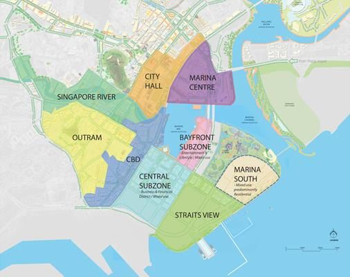
Developing the Financial and Business District in Marina Bay                                    Page 2 of 25

Nonetheless, the generally laissez faire approach towards planning and housing adopted by the
colonial government meant that by the 1950s, the downtown was characterised by
overcrowding, unsanitary squatters and slums, run down commercial buildings, street hawkers
and congested traffic. Many of the squatter houses were two- and three-storey shop-houses
partitioned into smaller units. The situation was exacerbated by the 1947 Rent Control Act
which was intended to protect tenants from excessive rent increases in the post-war years, but
in practice contributed to urban decay as property owners had little incentive to maintain or
improve their properties.

In post-independent Singapore, the Central Area 1 including the downtown, began to be
transformed through an extensive urban renewal and resettlement programme initiated in the
1960s by the newly elected People’s Action Party (PAP) government. The government’s vision
was to build a new modern city centre that would support the country’s industrialisation and
economic development.

Exhibit 1: Downtown Core Planning Area
Source: URA

1
 The Central Area currently comprises of 11 planning areas, namely Orchard, Museum, Rochor, Singapore River,
River Valley, Newton, Outram, Downtown Core, Marina South, Marina East and Straits View.

Developing the Financial and Business District in Marina Bay                                  Page 3 of 25

Starting from the northern and southern ends of the Central Area, the government – through
the Housing and Development Board (HDB), and particularly its Urban Renewal Division
(URD)2 – embarked on a systematic programme of urban re-development. The focus was on
re-developing state properties and properties that had reverted to the state on expiry of their
leases for housing and social uses. Private property owners and developers were also
encouraged to develop commercial and office buildings through the government’s sale of sites
programme. These efforts were augmented by the relaxation of rent control and, in some cases,
compulsory land acquisition by the government. One example of successful urban re-
development of commercial space during this period was the Golden Shoe district.

Within the Central Area, the CBD of the 1990s started from Tanjong Pagar and Anson Road
area up to Raffles Place, along the Shenton Way-Robinson Road-Cecil Street corridor 3
(referred to here as the existing or traditional CBD). What government planners now referred
to as the Downtown Core had grown over the decades to encompass not only the CBD, but
also its extensions in Marina Bay (i.e. planning areas of Central and Bayfront Sub-zones),
Marina Centre, City Hall and Bugis (see Exhibit 1). Today, Marina Bay generally referred to
the bay itself as well as the areas in Marina Centre, Clifford Pier, Central and Bayfront Sub-
zones that surrounded the bay.

Reclaiming land for city expansion
The practice of reserving land for the future growth of the CBD started soon after independence.
Besides land acquisition and resettlement, the government also continually reclaimed land from
the sea to create space for a rapidly growing Singapore. In mid-1960s, the government began
reclaiming land around Marina Bay in phases as part of the larger East Coast Reclamation
Project undertaken by HDB. By end-1977, phase V of the reclamation project had created 154
ha of land around the mouth the Singapore River between the Esplanade and the Collyer Quay-
Telok Ayer Basin (see Exhibit 2).4

When the concept of ‘Marina City’, a futuristic city-within-a-city for year 2000 and beyond,
was mooted in the late 1970s, it necessitated additional phases of reclamation. Phases VI and
VII of the reclamation project started in 1979, adding 234 ha of land off Tanjong Rhu and
another 126 ha to the earlier reclaimed land off Telok Ayer Basin.5 The process also created a
bay – Marina Bay – enclosed by reclaimed land. At $107 per square metre (psm), phases VI
and VII were the costliest of all the reclamation phases, as reclamation works extended into
deeper waters.6 Completed in 1985, the reclaimed land around Marina Bay was divided into
centre, south and east sectors.

The government also decided in the mid-1970s to move the rapidly growing international
airport from Paya Lebar to Changi by 1982. This freed the CBD and adjacent areas like Marina
Bay from planning constraints as they would no longer be under the flight path.

2
  URD was reorganised into a statutory board, Urban Redevelopment Authority (URA) in 1974.
3
  The traditional CBD covers the planning subzones of Anson, Tanjong Pagar, Maxwell, Cecil, Raffles Place,
Philip, and Clifford Pier within the Downtown Core Planning Area.
4 Chew, S. Y., and Wei, J. "Major reclamation scheme for Marina City, Singapore." Coastal Engineering

Proceedings 1, no. 17 (1980): 2247.
5 Ibid, 2246.
6 “More land for the city of tomorrow.” The Business Times, January 20, 1979.
Developing the Financial and Business District in Marina Bay                                      Page 4 of 25

In URA’s 1983 urban design plan for the Central Area, Marina Bay was envisioned to have an
expansive body of water, a sweeping promenade from Marina South to Marina Central, and a
gradual phasing of the city core extension to Marina Bay. The existing bay was however
considered too large for the proposed design. This prompted further work in 1990 to reclaim
another 38 ha off Marina South and near the mouth of the Singapore River at a cost of $180
million.7 The reclamation works were largely completed by 1993.

          Marina Centre

                  Marina Bay
                                                                              Marina East

                                              Marina South
Exhibit 2: Selected phases of East Coast Reclamation Scheme
Source: Adapted from Chew and Wei, 2246.

Part of Marina South adjacent to Shenton Way was earmarked as the new CBD extension and
would contain office and some residential developments, while Marina Centre would comprise
of commercial and hotel developments. Marina East would be mostly for residential use. By
the 1990s, new commercial developments, retail malls, convention space, hotels and a new
major arts centre (Esplanade – Theatres on the Bay) began sprouting at Marina Centre. In
contrast, the designated CBD extension in Marina South saw relatively little development until
the early 2000s.

Remaking the Singapore River
Alongside the urban renewal taking place in the Central Area in the 1970s, the Singapore River
was experiencing a decline in its traditional role as a harbour and transport route for
Singapore’s entrepot trade. Container port operations had commenced at Tanjong Pagar in
1972. By then, years as a centre of commerce and settlement had taken its toll on the Singapore
River which had deteriorated into a filthy open sewer.

As part of nation-wide efforts to clean up and develop a newly independent Singapore, then-
Prime Minister Lee Kuan Yew set a challenge to the Ministry of Environment in 1977 to clean
up the Singapore River within 10 years. This required a two-pronged approach on a massive

7
    “$180m URA project to create new downtown for the 21st century.” The Straits Times, October 1, 1989.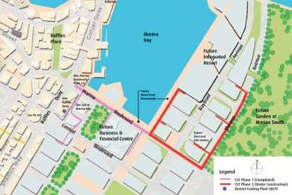
Developing the Financial and Business District in Marina Bay Page 5 of 25
scale to stop activities that polluted the river – which included trade effluents from over 2,800
enterprises and farms, as well as human waste from more than 26,000 families – and to clean
the river itself.8 Polluting activities and people living near the river also had to be resettled as
part of a longer term solution.
By 1983, well ahead of the ten-year target, the Singapore River had improved dramatically.
The Boat Quay, Clarke Quay and Robertson Quay stretches along the Singapore River were
later conserved. The restored traditional shop-houses and warehouses were put to adaptive
reuse as dinning, entertainment and leisure facilities, as well as offices and upmarket residences.
One
One Raffles
Marina
Quay
Asia Boulevar
Square The Sail d
The Lawn The Promontory Marina Bay
@Marina @Marina Bay
Marina One Bay Bay
Marina
(under Financial
construction ArtScience
Centre
) Museum
Marina Bay Sands
Gardens by
the Bay
Bay Central
Gardens by the Bay Marina Channel
Bay South
Gardens by
the Bay
Bay East
Marina
Barrage
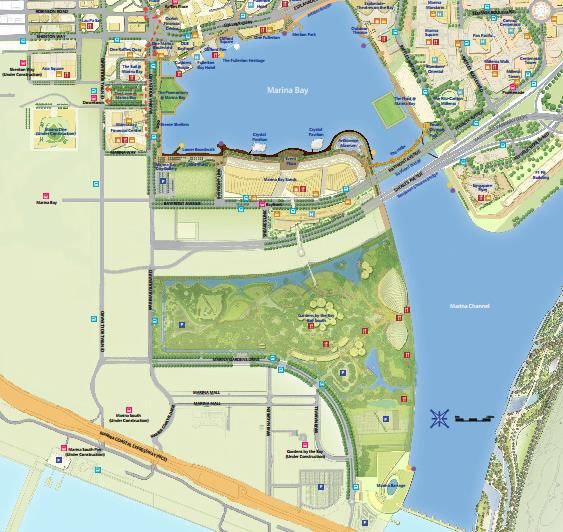
Exhibit 3: Present-day Marina Bay and Marina Channel
Source: Adapted from Marina Bay. “Marina Bay Maps.” https://www.marina-bay.sg/maps.html
A rejuvenated Singapore River that emptied into Marina Bay also laid the groundwork for later
plans to dam up Marina Bay and Kallang Basin to create a reservoir in the city centre. Thus in
2008, Singapore’s 15th reservoir, Marina Reservoir was created with the construction of the
Marina Barrage across the mouth of Marina Channel (see Exhibit 3). The Marina Barrage
8
National Environment Agency (NEA). “Singapore River Clean-Up: Against the Odds.” ENVISION, 1, 2011.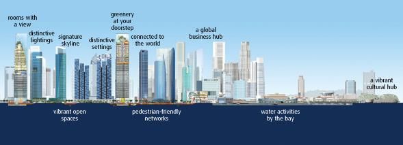
Developing the Financial and Business District in Marina Bay                                        Page 6 of 25

helped to keep out seawater from the reservoir and served as a tidal barrier for flood control,
especially for low-lying areas in the city. Marina Bay provided the city centre with an
impressive waterfront location for water activities. The Marina Barrage and its pump house
also doubled up as a public and recreation space in land-scarce Singapore, complementing the
new financial district at Marina Bay.

Development approach and challenges
     Our vision for Marina Bay is that of a 24/7 live-work-play environment – a new downtown
                    that is the essence of what we think we want a global city to be in the future.
                                               - Mah Bow Tan, National Development Minister9

The expansion of the CBD to Marina Bay reflected Singapore’s drive to become a global city
in an increasingly globalised and connected world. Although no single definition of global
cities existed, they tended to share certain characteristics: they were key nodes in the
organisation of the world economy, critical locations for finance and specialised service firms,
sites for innovation, and/or markets for the products and innovations produced.10

The idea of being a “global city” appealed to a resource-poor, land-scarce city-state like
Singapore. As early as 1972, Singapore was described as a “global city” by then-Foreign
Minister, Mr S. Rajaratnam. Mr Rajaratnam noted that with the support of modern technology,
Singapore was fast becoming a key component in a worldwide system of economies where the
world was its hinterland. 11 In Singapore, the “global city” idea gained increasing currency
among policy makers, and served as the context in which the development of Marina Bay came
to be viewed.

Strategic project in the Concept Plan
Having set aside a sizeable 360 ha of land at Marina Bay, the government took a phased
approach to its development. Marina Bay emerged as a key strategic project in the Concept
Plan 1991,12 which set out the vision and plans for Singapore's development over the next 20
to 30 years. Coming at a time when most of the basic needs of nation building had already been
met, the Concept Plan of 1991 envisaged Singapore as a “Tropical City of Excellence”.

In contrast to the traditional CBD which had grown organically over the years, Marina Bay
would be carefully planned by the government to create a bustling new city. The traditional
CBD was increasingly seen as deserted after office hours. A newspaper editorial in 1981
lamented that Shenton Way at night remained “as dead as ever… there is nowhere to go and
nothing to do when you get there.” It did not help that housing options in the CBD were limited.
Despite an earlier attempt by the government to allow some developers to add apartments on
top of office blocks, the CBD was essentially a single-use area where office space had crowded
out everything else.

9
  “More buzz at Marina Bay with new developments.” The Straits Times, July 28, 2006.
10
   Sun, Sheng Han. “Global city making in Singapore: a real estate perspective.” Progress in Planning, 64 (2005):
69–175.
11
   “Why Singapore has not collapsed.” The Straits Times, February 7, 1972.
12
   In the Concept Plan 1991, the area was referred to as Marina South.
Developing the Financial and Business District in Marina Bay Page 7 of 25 To be developed over two to four decades, the new downtown in Marina Bay would showcase an integrated live-work-play environment. It would be “a city centre that is alive day and night and (give) a stronger character to the heart of Singapore”.13 This entailed creating a new iconic downtown that was not only the centre of an international investment hub, but also featured hotels, offices, shops, nightlife, housing, as well as green, open spaces and tree-lined boulevards, all wrapped around the bay. At the same time, to avoid an over-developed and congested downtown, the Concept Plan proposed decentralisation in the form of regional centres in the east (Tampines), west (Jurong East), north (Woodlands) and northeast (Seletar),14 as well as a cluster of sub-regional and fringe centres. Following the 1991 Concept Plan, URA released its proposed detailed master plan for Marina Bay in the form of a Development Guide Plan (DGP)15 in 1997, covering the planning areas of Central and Bayfront Sub-zones, Straits View and Marina South (see Exhibit 4). In particular, URA demarcated a “New Growth Area” of 85 ha at Marina Bay (see Exhibit 5) with a long uninterrupted water front to serve as the new extension of the CBD. It was comparable in size to the 82 ha in the existing CBD, and twice as large as Canary Wharf, an upcoming financial district in London. The “New Growth Area” could potentially yield 2.82 million square metres (sqm) of office space.16 The plan to inject city living with space for 26,000 apartments was also a bold move, considering that the existing CBD had only 2,000 apartments.17 The 2001 Concept Plan continued the vision for Marina Bay, emphasising the need to reserve land in the city centre to support the growth of Singapore into a global financial hub. Prime Minister Mr Lee Hsien Loong described Marina Bay as the “centrepiece” of Singapore’s re- development of the city in his National Day Rally Speech in 2005.18 The development timeline for the financial and business district in Marina Bay is outlined in Annex 1. Growing the financial hub At the time, international competition to be the seat of global finance was intensifying among cities such as London and Hong Kong. In the late 1990s, the Monetary Authority of Singapore (MAS) started to liberalise the financial sector to propel Singapore from a regional to global financial hub. More foreign banks were given access to compete in the domestic wholesale and retail banking markets. The stock market and the stock broking industry were opened up. The insurance industry was also deregulated. Riding on growth in Asia, the wealth management 13 URA. “Living the next lap: Towards a tropical city of excellence,” 1991, 20. 14 Three of the four proposed regional centres have been developed, while a regional centre in Seletar was later deemed no longer needed. 15 Covering 55 planning areas, the DGPs were detailed land-use plans developed by URA following the launch of the 1991 Concept Plan, and were later co-opted into the statutory Master Plan in 1998. 16 URA. “Office Space in Singapore Set to Double.” Skyline, March-April, 2008. 17 “Govt to release commercial site in new downtown next year.” The Straits Times, August 21, 1996; “New downtown plan unveiled.” The Straits Times, August 21, 1996. 18 “Transcript of speech by Prime Minister Lee Hsien Loong at National Day Rally 2005.” August 21, 2005. http://www.pmo.gov.sg/mediacentre/transcript-speech-prime-minister-lee-hsien-loong-national-day-rally-2005- 21-august-2005 (accessed October 5, 2015); “Speech by Prime Minister Lee Hsien Loong at the Official Opening of Marina Bay Financial Centre.” May 15, 2013. http://www.pmo.gov.sg/mediacentre/speech-prime-minister-lee- hsien-loong-official-opening-marina-bay-financial-centre (accessed October 5, 2015). Mr Lee Hsien Loong was also Chairman of MAS from 1998 until 2004, and helped to push for a Business and Financial Centre at Marina Bay.
Developing the Financial and Business District in Marina Bay                        Page 8 of 25

segment grew dramatically. MAS deepened and broadened Singapore’s capital markets by
easing restrictions on Singapore dollar lending to non-residents.

These changes translated into a booming financial sector in Singapore with over 1,000 financial
institutions. The sector’s share of GDP increased from 9 percent in 2000 to about 12 percent
today. This in turn drove demand for space and supporting infrastructure. The global financial
industry was also going through a consolidation phase in the late 1990s, and the larger
institutions required bigger floor plates of contiguous and column-free space of 15,000 square
feet (sq ft) and above to accommodate their operations without being spread out over several
floors.19 Those working in the financial sector also appreciated integrated developments that
could incorporate offices with high-quality lifestyle and residential options.

Exhibit 4: Selected Planning Areas and Subzones in Central Area
Source: URA. “Master Plan – Central Area.” https://www.ura.gov.sg/uol/master-plan/View-Master-
Plan/master-plan-2014/master-plan/Regional-highlights/central-area/central-area#post2

The plan for Marina Bay was timely as years of development in the existing CBD had left little
room for further growth. Singapore was facing a severe office space crunch and rising rents in
the early 1990s. Office rents hit a high in 1990 when average prime rent reached $11.50 per sq
ft (psf) per month before dipping. But by 1996, average prime rent was again close to its 1990
peak.20 Singapore was in danger of becoming overpriced. The government also realised that
the infrastructure of the CBD was falling behind that of other major financial hubs such as

19   “Changing office landscape.” The Business Times, December 9, 1999.
20
     “Sizzling Real Estate Sector.” The Business Times, August 9, 2007.
Developing the Financial and Business District in Marina Bay Page 9 of 25
London with its Canary Wharf21 – a disused London Docklands site that was progressively
transformed into the city’s second financial district starting in the late 1980s.
Marina
Bay
Central Gardens by
Promontory Marina Bay the Bay
Central
Sands Bay South
Boulevard
site Marina
Barrage
Asia
Square
Marina
Marina View/ One
Union Square
site
Exhibit 5: Marina Bay New Growth Area
Source: Adapted from URA. “Office Space in Singapore Set to Double.” Skyline, March-April, 2008.
Public investments in Marina Bay
While private investments provided the muscle to develop Marina Bay, the precinct would not
have taken off without hefty upfront investment by the government to build up the necessary
infrastructure. As the centrepiece of Singapore’s development as a global city, Marina Bay
would not be fitted with run-of-the-mill infrastructure. The innovative and environmentally
friendly infrastructure systems designed for the area required large upfront investments. By
2009, public investments reached $7.5 billion, while private investments totalled $20.2
billion.22
Innovative infrastructure
One key piece of infrastructure was the custom-built Common Services Tunnel (CST), an
underground tunnel system bringing telecommunications fibre optic lines, electricity cables
and water pipes to buildings in Marina Bay. The CST saved land – about 1.6 ha 23 – and
minimized disruptions by eliminating the need to dig up the ground to add more infrastructure
21 Located in the former London Docklands in east London, construction of office complexes at the 40-ha Canary
Wharf started in 1988, and attracted tenants such as Morgan Stanley, Credit Suisse First Boston, HSBC and
Citigroup. Privately developed with government support, Canary Wharf was put under administration in 1992
when the original developer (Olympia & York) filed for bankruptcy in the wake of a property crash in London.
Although Canary Wharf lost tenants during the market crash, demand recovered in late 1990s. Today, Canary
Wharf has a working population of more than 100,000. Ownership of the current developer (Canary Wharf
Group), which owns more than half of the Canary Wharf developments, has passed through various hands,
including Qatari Investment Authority.
22
URA. “Uncovering the New Downtown.” Skyline, May-June, 2009.
23 URA. “Going beneath.” Skyline, November-December, 2001.Developing the Financial and Business District in Marina Bay Page 10 of 25
or access underground cables. Power cables and telecommunication links were also better
protected from accidents that might cause temporary loss of power.
URA had started planning the CST as early as in 1998 at an estimated cost of $1.35 billion.24
The high cost of the tunnel system was justified on the basis of the high land value and density
of development expected in the area. Construction started in 2001, and the tunnel system was
built in phases in tandem with the projected growth of the area (see Exhibit 6). The first phase
of 1.4 km was completed in 2006 at a cost of $81 million. With the tunnel reaching as deep as
20 m in some parts, the project faced several engineering challenges, including having to tunnel
through a 1.5 km-long colonial-era breakwater of solid rock underneath reclaimed land.
One Marina
Marina Bay Sands
Boulevard
One
Raffles Gardens by the
Quay The Sail@ Bay
Marina Bay South
Bay
Marina Bay
Financial Centre
Legend
CST Phase 1 (Completed)
CST Phase 2 (Under
Construction)
District Cooling Plant
Exhibit 6: Location of the first and second phases of the Common Services Tunnel network and pilot District
Cooling Plant at Marina Bay
Source: Adapted from URA. “State-of-the-art utility infrastructure in place at Marina Bay.” Skyline, July-August,
2006.
The CST network also housed the pipe network for the District Cooling System (DCS) – a
more energy efficient cooling system – which would deliver chilled water to cool buildings
(see Exhibit 6). Three district cooling plants were hosted at One Raffles Quay, One Marina
Boulevard and Marina Bay Sands. All developments, except residential developments, within
the designated service area were to be supplied by the DCS, instead of installing their own
cooling units. Refuse pipes would also be laid in the CST for Singapore’s first district
pneumatic refuse conveyance system, an automated system using air suction to transport refuse
through a network of pipes to a central collection point.
Public spaces
The land parcels were clustered around public open spaces and boulevards to create signature
districts. For example, the Marina Bay Financial Centre (MBFC) incorporated 13,000 sqm of
public open green space at The Lawn@Marina Bay which sat above the underground Marina
Bay Link Mall. The government set aside $300 million to develop additional infrastructure and
facilities, including a 3.5-km waterfront promenade and a 280-m pedestrian Helix Bridge to
24 “URA to build utilities tunnel network at Marina South.” The Straits Times, 7 March 1998.Developing the Financial and Business District in Marina Bay Page 11 of 25 complete the pedestrian “loop” around the Bay. 25 The Central Promontory (now The Promontory@Marina Bay) opposite The Lawn was also kept as public space. A stretch of green space in the form of the Central Linear Park linking Marina Boulevard to Straits Boulevard would also be constructed. Transport connectivity The development parcels in Marina Bay were planned according to a grid pattern to create a flexible framework that could accommodate the amalgamation, sub-division and phasing of developments as market needs evolved. The relatively large regular land parcels also allowed developers to offer large and regular-shaped floor plates. The grid pattern facilitated the implementation of a vehicular and pedestrian network with a clear sense of orientation and hierarchy. To encourage the use of public transport and walking within the precinct, the buildings were integrated with transport nodes through extensive underground pedestrian links that also shielded pedestrians from inclement weather. Developers also had to meet URA’s requirements for covered pedestrian walkways at street level as well as second storey pedestrian links to surrounding buildings. The new Marina Coastal Expressway (MCE) completed at the end of 2013, linked Marina Bay to the eastern and western parts of Singapore, replacing the East Coast Parkway (ECP) which had separated Marina Bay from the existing CBD. With the MCE, through-traffic could bypass city centre roads, thereby reducing congestion. The district was served by two MRT stations, i.e. Marina Bay station on the North-South and Circle Lines, and Downtown station on the Downtown Line. A third station on the future Thomson-East Coast Line (TEL) would be constructed at Shenton Way, while the Marina Bay station would also be connected to the TEL. Urban design URA also paid careful attention to designing the urban form of Marina Bay. The Central Promontory (now The Promontory@Marina Bay) and the Bayfront promontory (now the ArtScience museum) were identified as landmark sites – strategic and highly visible locations where developers and architects were encouraged to create distinctive buildings – in URA’s Landmark and Gateway Plan in 2001.26 Building heights along the waterfront and fronting key open spaces were kept low to maximise views for developments further away from the waterfront, creating a dynamic “stepped-up” skyline (see Exhibit 7). Developments at Marina Bay were put through a review process with the Design Advisory Panel convened by URA and comprising building and real estate industry members as well as other industry experts. Developers were also encouraged to incorporate open spaces and greenery, such as landscaped terraces and sky gardens, in their developments. Given their prominent location, standards were set for night lighting of buildings in the area to ensure that they enhanced the night environment for pedestrians and drivers. All new developments at Marina Bay were also required to attain the Building and Construction Authority’s (BCA) Green Mark Gold Plus or Platinum ratings for environmental sustainability. 25 “$300m boost for Marina Bay; Waterfront promenade and a pedestrian/vehicle bridge are part of plan to bring buzz to live-work-play zone.” The Straits Times, March 14, 2004. 26 URA. “One step closer to a unique city.” Skyline, November-December, 2001.
Developing the Financial and Business District in Marina Bay                                      Page 12 of 25

Exhibit 7: Variety of development intensities and building heights for Marina Bay
Source: Marina Bay. “Signature Skyline, Spectacular Views”. http://www.marina-bay.sg/signature.html

Government Land Sales
What remained to implement the government’s ambitious plans for Marina Bay was secure the
private sector’s participation. The Singapore government always had a comprehensive package
of regulatory tools to guide and influence the land market and the development process. Being
reclaimed land, the area was entirely under state ownership, in contrast to the existing CBD
where a sizeable portion was privately owned. 27 The Government Land Sales (GLS)
Programme was the main channel through which the sites were sold to the private sector on
99-year leasehold.

Most state land on the GLS programme were sold via an open tender system based solely on
price, although the sites, especially those in strategic and highly visible locations, were often
sold with tender conditions attached. Tender conditions usually related to urban design
standards that the winning bidder was required to meet. Written permission from URA was
required before any development (or re-development) can be carried out. The GLS programme,
which was carried out by URA, HDB and JTC as agents of the state, thus served as the key
mechanism for public-private collaboration to achieve national development objectives.

The tenders under the GLS programme were open to both local and overseas participants.
Indeed, the government made it a point to market Marina Bay internationally. Moreover, the
government was prepared to break from earlier policies and offered the private sector more
flexibility for land tenders in Marina Bay. At the same time, the government maintained a
controlled and coordinated process of development by setting broad parameters for developers
through the tender conditions.

However the government faced headwinds in the form of difficult market conditions, such as
the 1997 Asian financial crisis, the dot-com bust in the early 2000s, the September 11 terror
attacks in the US in 2001, the 2003 Severe Acute Respiratory Syndrome (SARS) episode in
Singapore, as well as the 2007-2009 global financial crisis precipitated by the US sub-prime
crisis. Viewed in this light, the consistent development of Marina Bay demonstrated the
government’s ability to innovate and fine-tune its policies, its willingness to take tough
decisions, and its responsiveness to market signals.

27
  Sun, Sheng Han. “Global city making in Singapore: a real estate perspective.” Progress in Planning, 64 (2005):
69–175.
Developing the Financial and Business District in Marina Bay                                    Page 13 of 25

A summary of the sale of sites in Marina Bay is provided in Table 1. Exhibit 9 shows the land
sale prices against GDP growth and URA’s Central Area office space rental index. Trends in
the vacancy rates and median rents of Category 1 office space and the office space rental index
for the Central Area are shown in Exhibit 10.

Flexible uses – white sites
From the start, URA designated 50 ha in the Central and Bayfront Sub-zones – about 13 percent
of the total land area – as “white” sites on 99-year leasehold. This was a departure from the
usual fixed-use zoning system of prescribing the development mix and quantum in a land sale,
as an incentive to developers.

First mooted in 1995, white site zoning gave developers more flexibility to decide on the mix
and quantum of a range of uses such as commercial, residential, hotel, clean industries etc.
(except pollutive industries) within the total permissible gross floor area (GFA) for the
development, without having to pay for the change in use. The approach hinged on the market's
ability to make better decisions on the use of a site, and broadened the potential for mixed-use
developments that encouraged a live-work-play environment.

Despite the zoning flexibility, the first white site – a 1.14-ha site at the junction of Raffles Quay
and Marina Boulevard – which was marketed as a landmark gateway to the New Downtown,
did not receive a single bid when it was put up for tender in November 1997. Market watchers
cited the weak economic climate in the midst of the Asian financial crisis, as well as the sheer
size of the project – almost double the floor area of Republic Plaza, the largest building in
Raffles Place then – in an untested location as key factors for the lack of bids.28 Developers
also found the financing process daunting, especially as banks were reluctant to lend during
the financial crisis.

The site was successfully sold in March 2001 – amid a more upbeat market and strengthening
demand for office space – at $462 million to a consortium held equally by subsidiaries of
Hongkong Land, Cheung Kong and Keppel Land.29 By 2006, the site had been developed into
One Raffles Quay, a Grade-A office building with two office towers catering to financial firms
with its large floor plates of 18,000 sq ft.

URA continued to use white site zoning to enhance the attractiveness of Marina Bay sites to
developers, while it experimented with other new approaches to land sales.

Testing the market – Reserve List
Introduced in June 2001, sites on the Reserve List system were not released for tender
immediately. Instead, a tender would be triggered when an applicant committed to a minimum
price (and deposited 5 percent of the minimum price) which was accepted by the government.
The minimum or “reserve” price is then made public in a subsequent open tender, although the
applicant was not identified. Unlike “confirmed” sites which were released at pre-determined
dates, “reserve” sites were only made available by market interest.

28
  “No bids for Marina Boulevard site; property stocks slide.” The Business Times, May 7, 1998.
29
  ORQPL, developer and owner of One Raffles Quay, is held equally by Freyland Pte Ltd, Comina Investment
Limited and Boulevard Development Pte Ltd, which are wholly-owned subsidiaries of Hongkong Land
International Holdings Limited, CKH China Enterprises Limited and Keppel Land Properties Pte Ltd respectively.
Developing the Financial and Business District in Marina Bay                                       Page 14 of 25

With the economy and property markets still in the doldrums in the early 2000s, the
government moderated the land supply by releasing sites for sale in 2002 via the Reserve List,
rather than the Confirmed List. Designed to give the private sector greater say in the supply of
land launched for tender, the Reserve List system was put to the test in Marina Bay.

A Marina Boulevard white site of 0.91 ha became the first reserve site in Singapore to be
triggered for public tender in March 2002, following an application with an offer of $280
million.30 The tender was subsequently won with a $288.9 million offer by a joint venture
between local property developer, City Developments Ltd (CDL) and AIG Asian Real Estate
Partners. Leveraging the flexibility of a white site amid a potential glut of commercial space
coming onto the market, CDL opted to develop Marina Bay’s first luxury residential project,
The Sail @ Marina Bay.31

A number of other sites in Marina Bay, including the strategic BFC site, were released through
the Reserve List. Placing sites on the Reserve List gave URA a better gauge of market interest,
without the corresponding pressure to sell. Some white sites in Marina Bay put on the Reserve
List have failed to reach the public tender stage (see Table 1). For example, a site along Marina
View (see Exhibit 5) placed on the Reserve List in October 2011 did not attract any applications.
More recently, a white site at Central Boulevard (see Exhibit 5) entered the Reserve List for
the second half of 2015.

Despite the market-friendly policies adopted by the government, the private sector’s response
to the sale of sites had, so far, been relatively tepid. This in turn could jeopardise the pace and
types of development in Marina Bay. A new approach was clearly needed.

Master developer and flexible payment scheme
The announcement of the Business and Financial Centre (BFC) in 2002 – the largest site to-
date in Marina Bay – was intended for the development of a strategic, Canary Wharf-style
mega-project.32 Flanked by Marina Boulevard and Central Boulevard, the BFC site was located
close to the existing CBD in order to jumpstart a critical mass of Marina Bay developments
(see Exhibit 5).33 Envisaged as a “city-within-a-city”, the 3.55-ha BFC site, including 1.8 ha of
subterranean space, would yield a total GFA of 438,000 sqm (approx. 4.7 million sq ft).

The government clearly hoped that the BFC development would propel the development of the
new financial district to the next level. But the mega project called for URA to introduce a
number of innovative approaches.

First, the site gave a master developer the flexibility to determine the mix of uses, and to design
and build in phases according to the market demand and tenants’ specifications, subject to
certain conditions. At least 60 percent of the GFA had to be built for office use, and up to a
maximum 40 percent of the GFA could be used for other commercial uses, as well as
complementary hotel, residential, entertainment and recreation uses. The site also required the
master developer to provide open spaces, courtyards and sky-gardens to enhance the

30
   URA. “First time this way.” Skyline, March-April, 2002.
31
   “CityDev gets OK to build homes on New Downtown site.” The Straits Times, January 25, 2003.
32
   “Single developer for new downtown; Flexibility first in radical new approach to developing huge Marina Bay
site and includes progressive payments scheme.” The Straits Times, August 16, 2002.
33
   “Location of Marina Bay office site unveiled; 3.5-ha site will be next to plot sold to CityDev last year.” The
Business Times, June 27, 2003.
Developing the Financial and Business District in Marina Bay                                        Page 15 of 25

attractiveness of the environment, including developing and landscaping a 1.37-ha Central
Open Space (now The Lawn@Marina Bay) to serve as a civic space and focal point for the
area.

Second, to mitigate some of the financing risks borne by the private sector taking on such a
large site, the government implemented a first-ever flexible payment scheme. Instead of
making the usual full upfront payment,34 the BFC master developer could pay only for land
required for the first phase of development (of at least 100,000 sqm of GFA), and purchase an
option for the right to buy the land in subsequent phases. The option periods would vary by six,
eight and ten years, subject to the payment of corresponding option fees of six percent, eight
percent and ten percent of the land price of the remaining phases. However to encourage the
developer to take an integrated approach to the BFC development, part of the option fee
(capped at 3 percent of the land price) could be used to offset the land price in subsequent
phases, if the option was exercised.

In the first phase, the land price was computed based on the tendered unit price. In subsequent
phases, the land price would be computed based on 50 percent of the percentage change in the
average Development Charge 35 rates for commercial land use in the core Central Business
District. In effect, the risk of subsequent land price volatility would be shared between the
developer and the government.

Exhibit 8: Site boundary plan for the BFC (Land Parcel A) and Central Promontory (Land Parcel B) sites
Source: URA. “URA Launches Tender for the Business and Financial Centre (BFC) at Downtown at Marina Bay.”
Annex 3A. March 1, 2005.
http://www.ura.gov.sg/uol/media-room/news/2005/mar/~/media/User%20Defined/URA%20Online/media-
room/2005/mar/pr05-08/pr0508a3ab.ashx

34
   As part of the tender process, URA required bidders to put up a 10 percent deposit, and the winning bidder had
to make full payment within 90 days of the tender award. This requirement had been put in place since the mid-
1980s as a safeguard against the risk of developers abandoning their projects before full payment for the sites was
made. Before then, payments could be made in instalments over a 10-year period.
35
   Development Charge is a tax that is levied when planning permission is granted to carry out development
projects that increase the value of the land.
Developing the Financial and Business District in Marina Bay                                      Page 16 of 25

Given that the overall project completion period could be as long as 18 years (if the developer
chose to purchase the site over ten years), URA put in safeguards against undue delays in the
development. The master developer would have to purchase the land to build at least 50 percent
of the overall GFA, i.e. 219,000 sqm (inclusive of the GFA in the first phase) within half the
option period, or lose the right to purchase subsequent land phases.

An adjacent 0.87-ha Central Promontory site (see Exhibit 8) was earmarked as a new public
attraction. The winning bidder of the BFC site would also have first right to purchase the
Central Promontory site, but had to set aside at least 60 percent of the 40,000 sqm GFA for
public attraction and/or convention uses.36 The permitted use for the remaining 40 percent GFA
was more flexible and included retail, food and beverage, recreational and entertainment
facilities.

However in the period following September-11, Singapore faced an uncertain external
economic environment weighed down by the Iraq war, and buffeted by SARS in early 2003.
Faced with a glut of office space, Raffles Place office rents in 2002 had fallen to their lowest
levels in 14 years.37

The actual launch of the BFC site on the Reserve List was delayed until May 200438 and in the
interim, URA continued to market the project at key industry events overseas such as MIPIM39
at Cannes. The subsequent BFC tender in 2005 attracted nine bids from local and regional
developers and conglomerates such as Wing Tai, Lippo, IOI and Far East Organisation. The
winning bid of $4,101 psm ($381 psf) of GFA came from a consortium formed by Keppel Land,
Cheung Kong and Hongkong Land. In fact, the winning bid turned out to be more than double
that of the Reserve List application that triggered the tender. This dispelled fears that the BFC
site and, by extension, the new Marina Bay financial district would face a lukewarm market
reception. What was perhaps even more heartening for the government was that the winning
bid had come from the same consortium that had successfully bid for the One Raffles Quay
site just a few years earlier.

The consortium took up an 8-year option to purchase the remaining 194,000 sqm of GFA.
Towards the end of 2006, offices rents had started climbing again amid signs of an office space
crunch in Singapore (see Exhibit 10). The consortium decided to exercise its option early in
February 2007, but declined to purchase the Central Promontory site. The Central Promontory
(now known as The Promontory@Marina Bay) later became a public events space. Renamed
Marina Bay Financial Centre (MBFC), the site eventually netted $1.9 billion40 in land sales
revenue for the state, excluding the 8 percent option fee. Completed in 2013, MBFC offered
nearly 3 million sq ft feet of Grade-A office space, two residential towers with 649 apartments,
and 179,000 sq ft of retail space.

36
   At least 15,000 sqm of this 60 percent would have to be used for public attraction uses such as museum, art
gallery, science centre, planetarium or aquarium.
37
   “Office rents plunge to 14-year low; Monthly rentals of office space in the prime Raffles Place area are down
20.7% to $5.45 psf, says JLL report.” The Straits Times, March 11, 2003.
38
   URA. “URA Releases the Business and Financial Centre (BFC) Site for Sale on Reserve List.” May 27, 2004.
39
   Marche International des Professionals de L’Immobilier.
40
   URA. “Historical data of sites sold – Commercial, Hotel, White, Industrial, Residential (excluding Landed
Housing) and Others Sites.” https://www.ura.gov.sg/uol/~/media/User%20Defined/URA%20Online/land-
sales/ura-vacant-sites.ashx (accessed July 6, 2015). This comprised of $1,000,644,000 ($4,101 psm GFA) for
GFA of 244,000 sqm in phase one, and $907,671,094.77 for remaining GFA of 194,000 sqm in phase two.
Developing the Financial and Business District in Marina Bay                                      Page 17 of 25

Table 1: Commercial developments in Marina Bay (Central sub-zone) and Shenton Way
              Site/                  Planning      GFA                  Tender/Land price           Developer/
 Year     Development       Type        area      (sqm)     $ psm ppr          ($)                 Winning Bidder
         Raffles Quay/
                         GLS (no     Central
 1998 Marina                                         -           -              -
                         bid)        Sub-zone
         Boulevard
         One Marina      Direct                                                                   Singapore Labour
 2000                                CBD         48,301      2,910.00     140,600,00041
         Boulevard       allocation                                                               Foundation
                                                                                                  Consortium of
           Raffles Quay/                                                                          wholly-owned
           Marina                                                                                 subsidiaries of
                                          Central
           Boulevard         GLS                       147,770     3,125.24       461,816,800     HongKong Land,
                                          Sub-zone
           (One Raffles                                                                           Cheung Kong
 2001
           Quay)                                                                                  Holdings and
                                                                                                  Keppel Land
                             GLS (1
           Central                        Central
                             bid                          -            -                -
           Boulevard42                    Sub-zone
                             rejected)
                                                                                                  City
           Marina
                                                                                                  Developments
           Boulevard (B)                  Central
 2002                        GLS                       118,182     2,444.53       288,900,000     Limited and AIG
           (The Sail @                    Sub-zone
                                                                                                  Global Real
           Marina Bay)
                                                                                                  Estate
                                                                                                  Consortium of
           Business &
                                                                                                  wholly-owned
           Financial
                                                                                                  subsidiaries of
           Centre                         Central
 2005                        GLS                       438,000     4,356.88    1,908,315,094.77   HongKong Land,
           (Marina Bay                    Sub-zone
                                                                                                  Cheung Kong
           Financial
                                                                                                  Holdings and
           Centre)
                                                                                                  Keppel Land
           Marina View
           Land Parcel A                  Central
                             GLS                       133,120    15,165.93      2,018,888,988    MGPA
           (Asia Square                   Sub-zone
           Tower 1)
 2007
           Marina View
           Land Parcel B                  Central
                             GLS                       113,580     8,389.58       952,888,888     MGPA
           (Asia Square                   sub-zone
           Tower 2)
           Marina View /     GLS (no Central
 2011                                                  101,628         -                -
           Union Street      bid)    Sub-zone
                             Direct  Central
 2012 Marina One                                       340,954       NA               NA          M+S Pte Ltd
                             allocation
                                     Sub-zone
        Central                      Central
 2015                  GLS                             145,600      TBA               TBA
        Boulevard                    Sub-zone
Source: URA; company websites (various)

41
     “SLF discloses price paid for Marina office site”. The Straits Times, April 16, 2003.
42
     This site was later amalgamated into the 3.55-ha Business & Financial Centre (BFC) site.
Developing the Financial and Business District in Marina Bay Page 18 of 25
8,389.58
Exhibit 9: Land price in Marina Bay against GDP growth and Central Area office space rental index
Source: URA REALIS, Department of Statistics
250.0 25
200.0 20
Rental index / Median Rentals
Vacancy rate (%)
150.0 15
100.0 10
50.0 5
0.0 0
1996 1Q
1996 3Q
1997 1Q
1997 4Q
1998 2Q
1999 2Q
2000 1Q
2000 3Q
2001 1Q
2001 3Q
2002 1Q
2002 3Q
2003 1Q
2003 3Q
2004 1Q
2004 3Q
2005 1Q
2005 3Q
2006 1Q
2006 3Q
2007 1Q
2007 3Q
2008 1Q
2008 3Q
2009 1Q
2009 3Q
2010 1Q
2010 3Q
2011 1Q
2011 3Q
2012 1Q
2012 3Q
2013 1Q
2013 3Q
2014 1Q
2014 3Q
2015 1Q
Vacancy rates of Category 1 Office Space (%) Office space rental index, Central Area (quarterly, Q4 1998 = 100)
Median Rents of Category 1 Office Space ($ psm per mth)
Exhibit 10: Category 1 office space vacancy rates and median rents, Central Area office space rental index
Source: URA REALIS
Note: Category 1 office space refers to office space in buildings located in core business areas in Downtown Core
and Orchard Planning Areas which are relatively modern or recently refurbished, command relatively high
rentals and have large floor plate size and gross floor area.Developing the Financial and Business District in Marina Bay Page 19 of 25 While the GLS programme served as URA’s main mechanism to spur private investment in Marina Bay, there were notable exceptions. For example, Marine One, an integrated development with a total GFA of 3.67 million sq ft, would be developed by M+S Pte Ltd, a 60- 40 joint venture between Malaysia and Singapore’s sovereign wealth funds, Khazanah Nasional Berhad and Temasek Holdings, respectively. The site was vested in M+S as part of a land swap deal between the governments of Malaysia and Singapore under the Malaysia- Singapore 1990 Points of Agreement, in exchange for land in Singapore formerly occupied by Malaysia’s Malayan Railways. Similarly, One Marina Boulevard was allocated to statutory board Singapore Labour Foundation (SLF) in 2000 to house the headquarters of National Trades Union Congress (NTUC). Encouraging other uses To cater for more hotels for business travellers within Marina Bay, URA imposed a minimum 25 percent of total GFA on a 0.9-ha site at Marina View to be set aside for hotel use, and a minimum of 60 percent of GFA for office use. Following the successful BFC site sale, the 0.9- ha site and an adjacent 1.02-ha site (see Exhibit 5) were sold at the end of 2007. Both sites were clinched by Macquarie Global Property Advisors (MGPA) for $0.95 billion and $2.02 billion respectively, to be jointly developed. The two sites were developed into Asia Square, the first Grade-A office development in the CBD to incorporate a 5-star hotel. In particular, the larger land parcel achieved a record-breaking $15,165.93 psm ($1,408.96 psf) GFA, more than triple the unit price paid for BFC. The Marina View tenders also attracted a different segment of private sector players, compared to earlier site sales which were dominated by local and Hong Kong real estate developers. MGPA was a private equity real estate fund management firm partly owned by Australia's Macquarie Bank Group.43 From land sales to place making URA had to go beyond its traditional role in land use planning and land sale management to play a more direct role in place management for Marina Bay. Although it was already closely involved in the development, the government officially appointed URA as the Development Agency for the Downtown at Marina Bay project in March 2004. This move signalled the government’s recognition that a strong coordinated approach across public sector agencies was critical, if Marina Bay was to become a hub not just for finance and business, but also for entertainment and leisure, integrated with homes and recreation facilities. A dedicated department – the Marina Bay Development Agency (MBDA) – was formed within URA to focus on the “software” aspects of developing Marina Bay.44 Working with public and private sector stakeholders, URA embarked on developing a consistent brand and marketing campaign for Marina Bay. However the agency ran into controversy in 2005 when it was revealed that URA had spent $400,000 on a rebranding exercise that, among other things, recommended that the area be called what it had been known as all along – “Marina Bay”.45 To build up buzz and market Marina Bay, MBDA served as place manager for Marina Bay, 43 MGPA was later acquired in 2013 by BlackRock, one of the world’s largest asset managers. 44 Ching, Tuan Yee and Ng, Benjamin. “Marina Bay: The Shape of Things to Come.” Ethos, 2, April 2007. https://www.cscollege.gov.sg/Knowledge/ethos/Issue%202%20Apr%202007/Pages/Marina-Bay-The-Shape-of- Things-to-Come.aspx (accessed April 20, 2015). 45 “Marina Bay the new brand name; URA will use concept to sell Singapore as a leading global city.” The Straits Times, July 22, 2005.
Developing the Financial and Business District in Marina Bay                                    Page 20 of 25

managing key public assets like the waterfront promenade, the Promontory and the Lawn.
MBDA also played a coordinating role for activities and events at Marina Bay organized by
various public agencies and private stakeholders, such as Marina Bay Singapore Countdown
and i Light Marina Bay, a light art festival.

Complementary developments
The transformation of Marina Bay did not focus solely on the development of the new financial
district. Two other major projects were taking place in parallel, adding to a string of
developments bringing vibrancy and character to the new city centre.

Plans for the Marina Bay Integrated Resort (later named Marina Bay Sands) – a large scale
development with a wide array of tourist attractions and amenities as well as gaming facilities
along the waterfront at Bayfront Avenue – were taking shape in the mid-2000s (see Exhibit 3).
In 2006, Las Vegas Sands won the tender, where the land price was fixed at $1.2 billion, with
a proposal involving investments of $3.85 billion on top of the land price. Dragged down by
the global financial crisis in 2008 however, construction for the massive site suffered numerous
delays before the Marina Bay Sands was officially opened in 2010.

The government also set aside more than 101 ha of reclaimed land for three public gardens
encircling the bay – Bay South (in Marina South), Bay East (in Marina East) and Bay Central
(in Marina Central) – which collectively made up Gardens by the Bay (see Exhibit 3). It was
not an easy decision for the government as it meant setting aside substantial tracts of valuable
land in the city centre.46 However the government envisioned that the new city centre needed
an iconic garden feature, similar to Central Park in New York or Hyde Park in London. The
54-ha Bay South was the first of the three gardens to be completed in 2012. It was also the
largest, and closest to Marina Bay Sands and the new CBD extension. Comprising of smaller
individual themed gardens, two conservatories and 18 Supertrees,47 it was built at a cost of
about $1 billion, excluding the land cost.

Next stage for Marina Bay
The development of Marina Bay was the result of a combination of public and private efforts.
One key success factor was the ability of the Singapore government to not only plan for the
long term, but also implement development largely according to its vision, adapting its plans
and approaches along the way as needed. The government played many roles ranging from
master planning and ensuring that the “New Growth Area” was well integrated with the larger
Central Area; implementing comprehensive public infrastructure; marketing the district
domestically and internationally, and finally, facilitating and guiding commercial development
by the private sector through the GLS programme. The private local and foreign equity invested
into Marina Bay was estimated in 2012 to be more than $25 billion.48

To what extent had Marina Bay supported the development of a new financial and business
district? As at third quarter of 2015, the total office stock in Singapore stood at 7.58 million
sqm of net lettable area.49 More than half was located in the CBD, including Marina Bay. In

46
   “Decision to build Gardens by the Bay not an easy one: PM Lee.” Channel NewsAsia, June 28, 2012.
47
   Supertrees are tall steel-framed concrete structures covered with a variety of plants.
48
   CBRE. “Special Report – Marina Bay: A Garden City by the Bay.” August, 2012.
49
   URA. “Stock & Vacancy and Supply in the Pipeline as at end of 3 rd Quarter 2015.” October 23, 2015.
You can also read