Developing Web-Based Tourist Information Tools Using Google Map
←
→
Page content transcription
If your browser does not render page correctly, please read the page content below
Developing Web-Based Tourist Information Tools Using
                    Google Map
                                       Bing Pana,
                                   John C. Crottsa, and
                                      Brian Mullerb
                 a
                     Department of Hospitality and Tourism Management
                               College of Charleston, USA
                                 {panb, crottsj}@cofc.edu
                                     b
                                      Butterfat LLC
                               Charleston, SC, 29401 USA
                                   muller@musc.edu

                                         Abstract
This paper reports an explanatory study of using Google Map API to develop two destination-
specific tourist information tools: a handheld tour guide and an online trip planner for
Charleston, South Carolina, USA. The background, development, functionality, and adoption
issues were discussed. The handheld tour guide is based on mobile phones with a GPS antenna
to communicate with Google Map and deliver real-time and location-sensitive tourist
information. Online Charleston trip planner combines destination specific information with
Google Map to provide an interactive trip planning tool based on the map metaphor. The
handheld tour guide is slow and unstable due to memory limitations and slow Internet
connection provided by the mobile phone service. The online trip planner is being adopted by
various hotels and conferences. The development effort demonstrated that Google Map API is a
flexible tool with reasonable speed for developing destination-specific online services. For
mobile tools, the computing power and wireless connections of small devices are the
bottlenecks when communicating with online services.
Keywords: GPS, GIS, Google Map, handheld, ubiquitous computing, tourist information.

1 Background
Advancements in technology have changed the way we travel and plan our trips.
However, trip planning online has been a frustrating experience (Pan & Fesenmaier,
2006). Information on various aspects of a trip and destination is distributed: travellers
may need to book an airline ticket from expedia.com; then he/she goes to Hilton.com
to find the hotel room and then switches to a local convention and visitors bureau site
to check out destination information. However, travellers need to put together these
pieces of tourist information in their trip plans: they need to find out the relevant
distance from the airport to the hotel, as well as the distance between different
attractions and the accommodations (Duran, Seker, &Shrestha, 2004). Frequently, the
travellers will rely on offline tools, such as pencil and paper, to record their locations
and then using online mapping tools to piece together the relevant locations (Pan &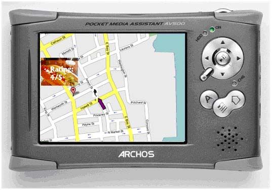
Fesenmiaer, 2006). The current trip planning practices apparently lack the integration
of location information of various aspects of the trips.

On the other hand, anecdotal evidence confirmed that with the ubiquitous information
access and more hectic life styles, travellers plan less and less ahead of a trip and
engage in more on-route and in-destination planning (Fesenmaier & Vogt, 1992;
Fesenmaier, Vogt, & Stewart, 1993). For example, travellers frequently call hotels to
reserve a room while in the car or check out adjacent attractions while touring a city.
Ad-hoc decisions on restaurants or attractions are also a part of the fun during a trip
which can create pleasant surprises.

However, travellers still could not access all the travel related information as they
wish. For example, if a traveller walks around downtown in a destination, and sees a
restaurant on the corner of King Street and Calhoun Street, she could not check out
the rating and other visitors’ comments about the restaurant easily. Similarly, if she
sees a beautiful house on Meeting Street, she would like to know when it was built,
and its architectural and historical significance. She could not obtain this information
without joining a tour group or having a mobile phone with web access. In the latter
case, the information access is still awkward since she need to search on the web
through her tiny cell phone screen. Thus, providing appropriate destination related
tourist information to the right visitors at the right time and the right place is still a
challenge and much is needed for next generation of information technologies for
tourism industry.

Recent technology developments based on Geographic Information System (GIS) and
satellite images have provided a new way of accessing location-based information.
Google Map can provide interactive mapping services as well as realistic satellite
images. More importantly, the free Google Map Application Programming Interface
(API) (Google, 2006) allows thousands of programmers to tap into the powerful
Google mapping service by connecting it with various types of data, from sex
offenders’ addresses to the demographic information of the United States (Darlin,
2005). Combined with destination-specific tourist information, Google Map could
provide a new way of trip planning and tourist information accessing. This paper
documents the effort in developing two web-based destination information tools for
Charleston, South Carolina, USA, based on Google Map API: a handheld Charleston
tour guide and an online interactive trip planner to Charleston; it discusses the
advantages and limitations of using Google Map API to develop trip planning and
tourist information accessing tools.

2 Recent Developments on Ubiquitous Computing and Mapping
  Services
Recent developments in hardware, software, and openly available geographical data
have provided new opportunities for developing location-based tourist information
access and trip planning tools. This section briefly reviews the relevant development.
While computing devices are getting smaller, smarter, and more connected, any time
and any access to any information during a trip is becoming a reality (Weiser, 1994).
Most current models of mobile phones and Personal Digital Assistants (PDA) have
the capability to access the Internet through wireless connections. Laptops could also
access phone service network for Internet connections while Wi-Fi spots are not
available. However, the speed of Internet access on mobile devices vary: the new
standard 3G technology could provide download speeds of 150 Kbps to 700 Kbps and
a speed of 150 Kbps max for uploading; most current mobile devices can only have a
speed of 50Kbps (Null, 2006; Glenn, 2006). None of these standards can rival
broadband access through landlines. In addition, the limited screen side of most
mobile devices restrict its extensive usage on cognitively intensive tasks.

Geographical Information System (GIS) have been adopted widely in tourism
settings, from information kiosks, hiking maps, to web-based maps (Duran, Seker, &
Shrestha, 2004). Those online GIS tools combine the power of GIS with the ubiquity
of the Internet. Google Map is one web-based tool which can be used to access large
amounts of geographical information as well as routing capability. Google Map
Application Program Interface (API) allows a programmer to embed Google Maps in
his/her own web pages with JavaScript. A programmer can add overlays to the map,
including markers and polylines, and display information windows linked to other
data sources. The Maps API is a free service and available for any web site that is
free to consumers (Google, 2006).

Recently there have been developments in both integrated and location-based trip
planning tools and mobile information access. Duran, Seker, and Shrestha (2004)
provided a conceptual model and technical on the uses of integrated web-based GIS
system combining geographical data with tourism data for public and management
usage. Brisaboa et. al. (2003) developed an interactive map with JavaApplet to access
touristic and cultural information of Galicia, Spain. They used GIS technology
combined with multimedia databases to present multimedia content. The two interface
metaphors they are using are browsing and map metaphor. However, the JavaApplet
needs a certain period of downloading time and requires Java Virtual Machine to run
on the client side of the computer.

Furthermore, various GPS (Global Positioning System) based technologies are getting
more and more affordable. For example, GoCar, A GPS-guided storytelling car, has
gained more and more popularity in San Francisco (GoCar, 2005). The small car
navigates and shows the driver directions as well as acting as a tour guide for
directing the tourists to the best sites and telling the stories that bring San Francisco to
life. However, the rental fee of GoCar is relatively expensive and it might not be
suitable for use in certain cities which have narrow streets. Using mobile devices to
access location-based information might be a good direction for developing tourist
information tools. A mobile tour of Cornell campus has been developed in which a
mobile phone with location information could guide the visitors of the campus to
hidden treasures of Cornell University (HCI Lab, 2005).

3 Theoretical Foundations and Issues
Various theories have pointed to the power of map metaphor and mapping interface.
People engage in cognitive mapping as they collect, organize, store, remember and
utilize information about their surrounding environment. Travellers build cognitive
maps of the destinations through direct experience, roadside signs and tourist maps
(Downs & Stea, 1977; Guy, Curtis, & Crotts, 1990). Research has shown that
cognitive maps could substantially influence consumer’s commerce or interactions
with the environment, including exploring, touring, shopping, purchasing, and
patronage (Grossbart & Rammohan, 1980; Holahan & Dobrowolyn, 1978; Guy,
Curtis, & Crotts, 1990). However, one of the most important tool for building
cognitive maps, the physical tourist maps, are usually static, limited in the volume of
information, and could be complicated to use for first-time visitors because of the
unfamiliarity with the orientation and layout of the city.

We hypothesize that location-based information trip planning and on-route and
during-trip information providence could help the visitors to build cognitive maps
more quickly and in more details. As a result, those visitors will be more engaged,
visit more attractions, spend more on food and entertainments, achieve a higher
satisfaction, and become more loyal customers. The goal of the proposed project is to
build and test two web-based tools: a GPS-enabled handheld information device for
the visitors to tour downtown Charleston, South Carolina, USA; and an online
interactive trip planning tool for the same destination. Specifically, Travellers to
Charleston complained about the confusing traffic signs, complicated road network,
and busy traffic conditions. Pre-trip planning can help to build cognitive maps and
reduce stress during the visiting period; these types of information can also be
delivered to a traveller in real-time through wireless and location-sensitive
information access. The first tool will provide visitors with location-sensitive texts,
images, audios, and videos based on their actual physical locations; the second
program will help the visitors plan their trips to Charleston using an interactive map
prior to their departure or in their hotel rooms. It was expected that these tools could
increase the visitors’ satisfaction about the destination, promote more visitations to
different attractions, increase sales on food, entertainments and attractions, and foster
more loyal visitors. Potentially the devices could become a new marketing channel
and a new revenue source for the technology services. It should be noted that this
study is not a complete research effort on the usefulness of Google Map, but rather an
explanatory study on the researchers’ and developers’ own experience.

4 Developments of Handheld Charleston Tour Guide
4.1 Conceptualization

In the conceptualization stage, the developers are expected to build a piece of
software based on a handheld device equipped with GPS. The multimedia content,
including text, images, audio and video will be stored on the hard drive of the mobile
device. Based on the identification of location through the GPS chip, the mobile
device could dynamically update the map location and orientation, and provide
multimedia information if requested by the traveller. Furthermore, a website is
planned to set up so that various tourism businesses, including hotels, restaurants, and
attractions, could update their information on a daily even hourly basis, for example, a
special deal for the day if the restaurant is short of customers or a hotel is having a
low occupancy rate. It could generate a new type of marketing channel in which the
businesses are advertising to the visitors with close spatial proximity and who are
likely to be hungry or tired. See Fig. 1 for an initial conceptualization of the device.

            Fig. 1. Conceptualization of Charleston Handheld Tour Guide

4.2 Technical Development

In the actual development stage, the device chosen was HP iPAQ hw6500 Pocket PC
combined with Cingular network service (HP, 2006). This device runs on Windows
Mobile 2003 which ensures maximum development capability; it has a build-in GPS
receiver; is uses the integrated GSM/GPRS/EDGE and quad-band GSM phone
capabilities which provide reasonable data access through Cingular network. It has
64MB built-in SDRAM and 64M Flash memory. Because of limited financial
resources, a stand-alone program is estimated to cost around one year-person
programming time and around 70K labour cost since it needs to build a GIS
application on this Pocket PC. Thus, a web-based solution is adopted which uses
Google Map API.
Technical structure of the device is described in Fig. 2. First, the information about
the members of travel council, a destination marketing organization, was collected
and a database of attractions, hotels, restaurants, and recreation facilities of Charleston
was built with their GPS coordinates. A user interacts with the web browser Minimo
on the handheld device. A program on the handheld is developed to retrieve location
information from the GPS antenna and then pass the location information to the
application web server. The application web server uses the location information to
pass it to Google Map server and retrieve map images and routing information. In
addition, the application web server retrieves the tourist information database an
overlay them with Google Map. It then returns the map images and tourist
information to the web browser on the handheld through wireless data transfer. The
user of the handheld device could choose to display different types of tourist
information at his or her will. The actual user interface is shown in Fig. 3.
JavaScript Wireless
User Web Browser
Connection
Broadband
Application Google Map
Web Server Server
Connection
GPS Program
Hand held Device
Tourist
Information
Database
Fig. 2. The Technical Structure of Handheld Charleston Tour Guide
4.3 Problems and Issues in Testing
After the finish of the prototype, a few researchers conducted a few user testing
sessions in downtown Charleston. The prototype of the handheld device works with a
few limitations. The speed of wireless data connection is low and thus the refreshing
of Google Map screen is slow and always lagging behind the walking speed of the
testers. In addition, the web browser on the handheld device, Minimo, requires certain
amount of memory to run. The existing memory of 128MB is not sufficient and
causes frequent crashes. The device needs to restart from time to time. Thus, the speed
of wireless connection and the memory of the handheld device are two major
bottlenecks of the program. Again, a standalone program without using the web
browser and Google Map API may bypass these bottlenecks. However, the cost of
developing are rather high and it is not very scalable: for example, a different program
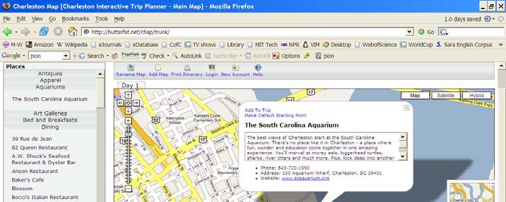
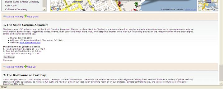
will be needed to develop another program for a different destination.Fig. 3. Handheld Charleston Tour Guide 5 Developments of Interactive Online Charleston Trip Planner 5.1 Conceptualization As discussed before, online tourist information is distributed in different parts of the web space and an integrated trip planning interface is needed. Also a map metaphor could take advantage of visitors’ cognitive mapping capability and increase their satisfaction level, purchase intention, involvement and loyalty in visitation. The online Charleston trip planner is based on the basic structure used in handheld Charleston planner project. Instead of using it during a trip, this tool is intended for the visitors to plan trips before actually leaving their homes or in their hotel rooms. The visitors should be able to plan trips using this interactive interface, save their itinerary, add comments and notes, and print out a paper copy and carry with them to the destination. 5.2 Functionality and Technical Development Fig. 4 shows a screenshot of the interface. On the left side, various tourist attractions, accommodations, and dining places retrieved from the travel council database, which is built in the first development project for the handheld tour guide. The visitors will
be able to add these different properties to their itinerary. When added, the locations
of those selected will show up on the map. When multiple addresses were added,
directions between those locations will be automatically displayed at the bottom of the
page. The user will also be able to move the locations up and down, rearrange them,
and set one of them as default starting point. A user will be able to add another map in
which he/she could plan itinerary for another day. When finished, he/she could print
the itineraries for multiple days out with each individual itinerary and carry it during
the trip.

    Fig. 4. Online Charleston Trip Planner (http://www.ota.cofc.edu/tripplanner/)

The program uses cookies to track the user session. So a user visits the site for the
second time from the same computer will have all the previous selections and routing
information retrieved and displayed. In addition, a user will be able to create an
account using his/her email address and store all the itinerary information in his/her
account. By pressing a button, the itinerary information can be emailed to the user.
Fig. 5. The Technical Structure of Online Charleston Trip Planner The software utilizes a Linux/Apache/MySQL/PHP combination on the backend, and asynchronous JavaScript on the front end. The client browser first loads a blank template page that contains layout but no content. The JavaScript then requests different lists of necessary content from the server. Based on these lists, the client can then requests the elements in the list. What is returned in both cases from the server is either in XML or JSON (JavaScript Object Notation) and is dependant upon the existence and content of the client's previous session information. The user interface is then constructed based upon this data. Most interaction between the user and their browser results in communication with the server to maintain a persistent state based upon the client's session. Fig. 5 depicts a diagram of the technical structure. 5.3 Adoption and Promotion Various conference organizers in Charleston have showed interests to adopt it as a trip planning tool for their participants. A few customized trip planning tools are being developed for a few conferences planned in Charleston area. Initial feedbacks from meeting planners indicate that this is a very useful and intuitive interface for meeting and convention participants. 6 Conclusions and Future Development This paper documented the effort of developing tourist information tools using Google Map API. This is not a complete research effort on the usefulness of Google Map, but rather an explanatory study on the researchers’ and developers’ own experience. The program developed by the researchers is scalable and can be easily customized to other destinations and areas. For mobile computing devices, the
computing power and wireless connections of small devices are the bottlenecks in
terms of communicating with online services.

More intensive and formal user testing is under the way for the online trip planning
tool in order to improve the usability of the interface. Furthermore, with the
advancement of hardware, especially faster wireless connections (3G technology) and
increased memory of handheld technologies, it is expected that the Charleston
handheld tour guide could work more effectively. Combining the tour guide with the
trip planning tool could integrate pre-trip plan with during-trip planning and provide
more personalized and relevant information during a trip. In addition, post-trip
evaluation can be integrated into the system in which the users will be able to rank the
different properties they have gone to. Future development can also include an
interface for tourism enterprises to update their information daily even hourly (for
example, a special deal for the day) to market toward visitors on the road or 100 or
200 yards around them. Location and map-based tourist information tools based on
Google Map API opened many opportunities to enhance visitor experience as well as
connecting visitors with tourism properties in destinations.

References

Brisaboa, N.R., Farina, A., Luaces, M.R., Parama, J.R., Penabad, M.R., Places, A.S., &
        Viqueira, J.R. (2003). Using geographical information systems to browse touristic
        information. Information Technology and Tourism, 6, 31-46.
Darlin, D. (2005). A journey to a thousand maps begins with an open code. New York Times,
        October 20, 2005, Technology Column.
Duran, E., Seker, D.Z., & Shrestha, M. (2004). Web based information system for tourism
        resort: A case study for side/manavgat. InProceedings for XXth International Society
        for Photogrammetry and Remote Sensing, Istanbul, Turkey: July 12-23, 2004.
Fesenmaier, D., & Vogt, C.A. (1992). Evaluating the utility of touristic information sources for
        planning midwest vacation travel. Journal of Travel & Tourism Marketing, 1992, 1(2):
        1-18.
Fesenmaier, D., Vogt, C.A., & Stewart, W.P. (1993). Investigating the influence Of welcome
        center information on travel behavior. Journal of Travel Research, 31(3): 47-53.GoCar.
        (2005). GoCar Rentals. Available: http://www.gocarsf.com.
Glenn, F. (2006). Get online from anywhere. MacWord, 23(9), 72-73.
Grossbart, S.L., & Rammohan, B. (1980). Cognitive maps and shopping convenience. In K.
        Moore (Eds). Advances in Consumer Research, Association for Consumer Research.
Guy, B.S., Curtis, W.W., & Crotts, J.C. (1990). Environmental learning of first-time travelers.
        Annals of Tourism Research, 17: 419-431.
HCI             Lab.          (2005).           Hidden            treasures.          Available:
        www.hci.cornell.edu/projects/hidden_treasures.htms.
Holahan, C., & Dobrowolny, M.B. (1978). Cognitive and behavioral correlates of the spatial
        environment. Environment and Behavior, 10(3), 317-333.
HP.      (2006).     HP    iPAQ      hw6515a      Pocket     PC.      Available    online     at:
        http://www.shopping.hp.com/webapp/shopping/product_detail.do;jsessionid=FEwhJNX
        s8NZAedSjCtb9YEJFgaV2uXnAb3wzY1lpsYaPKwkbwDgr!-
        282458288?storeName=storefronts&landing=storefronts&category=handhelds&orderfl
        ow=1&product_code=FA637A%23ABA&catLevel=1
Null, C. (2006). Broadband to go. PC World, March, 2006, 97-104.
Pan, B., & Fesenmaier, D.R. (2006). Online information search and vacation planning process.
        Annals of Tourism Research, 33(3), 809-832
Weiser, M. (1994). The world is not a desktop. Interactions, 1(1), 7-8.
Acknowledgements Special thanks go to Matthew Gregg (Butterfat, LLC), Christopher Zorn (Butterfat, LLC), Garry Vetter (College of Charleston), Paul Buhler (College of Charleston), and Dr. Frank Starmer (Duke - National University of Singapore Graduate Medical School) for their support and hard work on this project.
You can also read