DEVELOPMENT COMMITTEE MEETING TUESDAY 16 OCTOBER 2018 ATTACHMENT TO ITEM DV18.154 - DRAFT TOWN OF CAMBRIDGE WALKING TRAIL STRATEGY 2018-2021 ...
←
→
Page content transcription
If your browser does not render page correctly, please read the page content below
DEVELOPMENT COMMITTEE MEETING

    TUESDAY 16 OCTOBER 2018

  ATTACHMENT TO ITEM DV18.154

 DRAFT TOWN OF CAMBRIDGE WALKING TRAIL
  STRATEGY 2018-2021 - CONSIDERATION OF
    SUBMISSIONS AND FINAL ADOPTION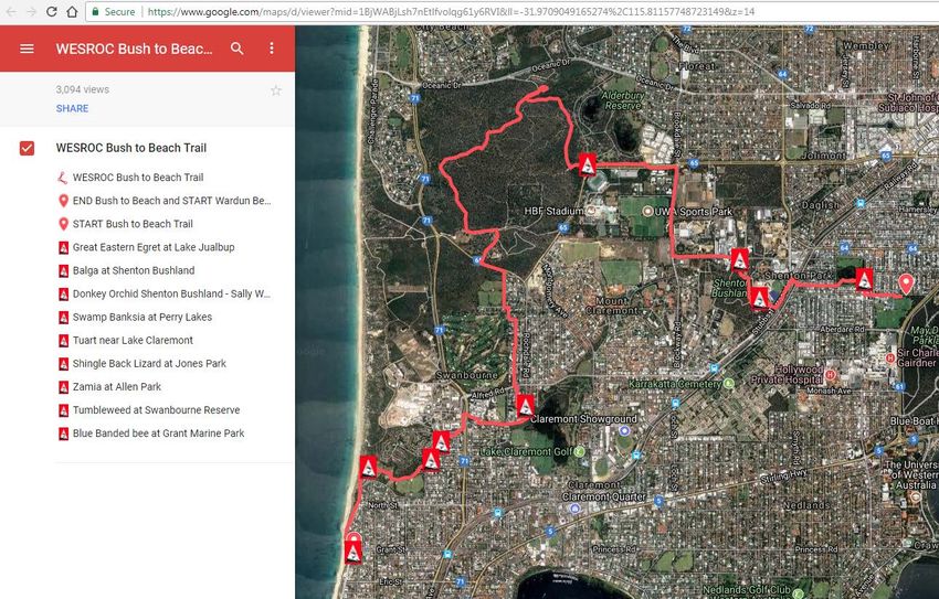
Town of Cambridge
Draft Walking Trail
Strategy 2018-2021

         1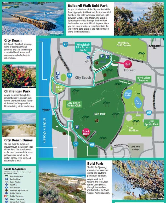
Contents
Executive Summary ........................................................................................................................................3
Introduction....................................................................................................................................................4
   Western Australian Strategic Trails Blueprint 2017-2021 ..........................................................................4
   What is this Strategy? .................................................................................................................................5
Current Trail Network ....................................................................................................................................5
   a) State trails ...............................................................................................................................................5
   b) Regional trails .........................................................................................................................................6
   c) Local trails ...............................................................................................................................................9
        Cambridge Heritage Trail ........................................................................................................................9
        Bold Park Trails .....................................................................................................................................10
Strategy ........................................................................................................................................................11
   New trails ..................................................................................................................................................11
        1. City Beach Trails ................................................................................................................................11
        2. Wembley Golf Course Trails ..............................................................................................................13
        3. Wembley Wetlands Loop ..................................................................................................................14
        4. Sunset Coast Trail..............................................................................................................................15
   Linkages ....................................................................................................................................................17
        1. Extension of the Cambridge Heritage Trail .......................................................................................17
        2. Perry Lakes Heritage Trail .................................................................................................................18
        3. Whadjuk Trail Linkages .....................................................................................................................20
        4. Bold Park ...........................................................................................................................................20
Implementation ...........................................................................................................................................20
   1.       Mapping ...........................................................................................................................................20
   2.       Signage .............................................................................................................................................22
        a) Directional markers...........................................................................................................................23
        b) Interpretive signage ..........................................................................................................................25
        c) Stencilling ..........................................................................................................................................25
   3.       Digital wayfinding and information ..................................................................................................25
   4.       Marketing .........................................................................................................................................25
   5.       Aboriginal Consultation ....................................................................................................................26
   6.       Funding and grants ...........................................................................................................................26
   7.       Monitor and review..........................................................................................................................26
   8.       Accessibility and Inclusion ................................................................................................................26
   9.       Further considerations .....................................................................................................................27
   10.          Consolidated Trail Information and Concept Map.......................................................................27

                                                                                 2
Executive Summary

The Town of Cambridge benefits from very good existing infrastructure to support walking,
both locally and linking with regional pathways. The Town's natural assets, cultural heritage
and destinations combine to offer many reasons for walking.

The development of a trail network supports the Town's Strategic Community Plan 2018-
2028. Goal 3 encourages an 'active, safe and inclusive community', strategy 3.4 aims to
'create and maintain safe, friendly and open environments that residents can access and
enjoy'.

The Walking Trail Strategy has been developed to build upon these existing assets to
recognise, promote and guide development of walking trails through the Town encouraging
greater accessibility to our natural areas and open spaces.

Existing recognised regional and local trails within the Town total a distance of more than
40km, with the majority of these trails signposted and marketed through various channels.

This Strategy identifies an initial additional 20kms of trails using existing infrastructure that
will be recognised, signposted and marketed in a staged approach. Future trails and
linkages will be identified through public consultation involvement to create a diversified and
connected network of trails through the Town.

                                                3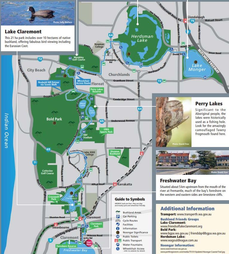
Introduction
Recreational walking is the most popular form of exercise with 45.3% i of adults regularly
walking for exercise. More than half of women regularly walk as well as nearly one-third of
men.

Walking trails are recognised routes that can combine physical exercise with cultural,
historical and environmental learning and awareness. The benefits of walking trails are
numerous and include the following:

   •  Encouraging more frequent outdoor physical activity leading to improved physical
      and mental wellbeing and a reduction in lifestyle diseases and associated medical
      costs;
   • Improved lifestyle due to opportunities for outdoor recreation by individuals, groups,
      and education and community organisations;
   • Providing low cost facilities for recreation accessible to many different groups in the
      community;
   • Improved awareness and appreciation of the natural environment and support for its
      conservation and protection;
   • Economic benefits from employment and business opportunities in trail development,
      management, maintenance, events and supporting products and services;
   • Tourism growth to trail destinations with resulting economic stimulus of local
      economies;
   • Protection and showcasing of natural, cultural and historic areas by providing for
      sustainable access routes; and
   • Improved sustainability of local communities by making them more attractive places
      to live. Opportunities for social interaction and development of community identity
      through participation in trail activities, maintenance and conservation.
   Source: Western Australian Strategic Blueprint 2017 - 2021, p.22. ii

Western Australian Strategic Trails Blueprint 2017-2021

The Department of Sport and Recreation (now called Department of Local Government,
Sport and Cultural Industries) publication, 'Western Australian Strategic Trails Blueprint 2017
- 2021' (the Blueprint) provides an overarching guide for consistent and coordinated
planning, development and management of quality trails and trail experiences across
Western Australia.

The Blueprint identifies 10 categories of trails:

       1.      Bushwalking Trails
       2.      Urban Walking Trails
       3.      Mountain Biking Trails
       4.      Cycle Trails
       5.      Equestrian Trails
       6.      Paddle Trails
       7.      Snorkle and Dive Trails
       8.      Trail Bike Trails
       9.      Drive Trails (2WD)
       10.     Drive Trails (4WD)

                                                    4
Walking trails within the Town would fall under the Bushwalking Trails as local examples,
and Urban Walking Trails category, though it is recognised that some trails are also used in
part for cycling.

The Blueprint recognises the levels of planning required for trail development throughout the
State and encourages the development of Localised Trails Plans. This Strategy falls within
this category.

The Department of Local Government, Sports Cultural Industries (DLGSC) and Lotterywest
offer trails grants to assist in developing trails. A key objective of this Strategy is to support
grant funding applications to assist the implementation of the Strategy and therefore the
Strategy has been prepared in accordance with the requirements of the DLGSC.

What is this Strategy?
The Walking Trails Strategy has been prepared to recognise the existing walking trails within
the Town and to utilise existing infrastructure and assets to identify new walking trails that
can diversify or integrate into the existing trails.

The Walking Trails Strategy will provide a holistic overview of existing regional and local
recreational trails and identifying linking trails as well as creating a trail network that will
benefit the whole community by making use of existing infrastructure and paths.

The main purpose of a trail network is to increase physical activity, however, trails also allow
for social connectivity. The Town of Cambridge has a wealth of public open spaces and
natural areas. A trail network will allow for greater access to these areas whilst linking places
of interest. Examples of similar Council trails can be found on the 'Be Active WA' website
under walk maps. iii

Current Trail Network
The Blueprint (page 51) classifies trails into:
a) State trails;
b) Regional trails; and
c) Local trails.

a) State trails
State trails are extended trails or a network of trails that is of sufficient quality and with
appropriate facilities, products and services to be recognised beyond the State and to attract
visitors to WA. An example of a State trail is the Bibbulmun Track stretching from
Kalamunda to Albany through the South West. iv

At present no State trails are located within the Town's boundaries; however the Whadjuk
Regional Trail Network has the potential of becoming a State trial should the trails be
extended into neighbouring Councils such as the cities of Stirling, Vincent and Wanneroo.
These Councils have all indicated an interest into the extension of the trails.

                                                  5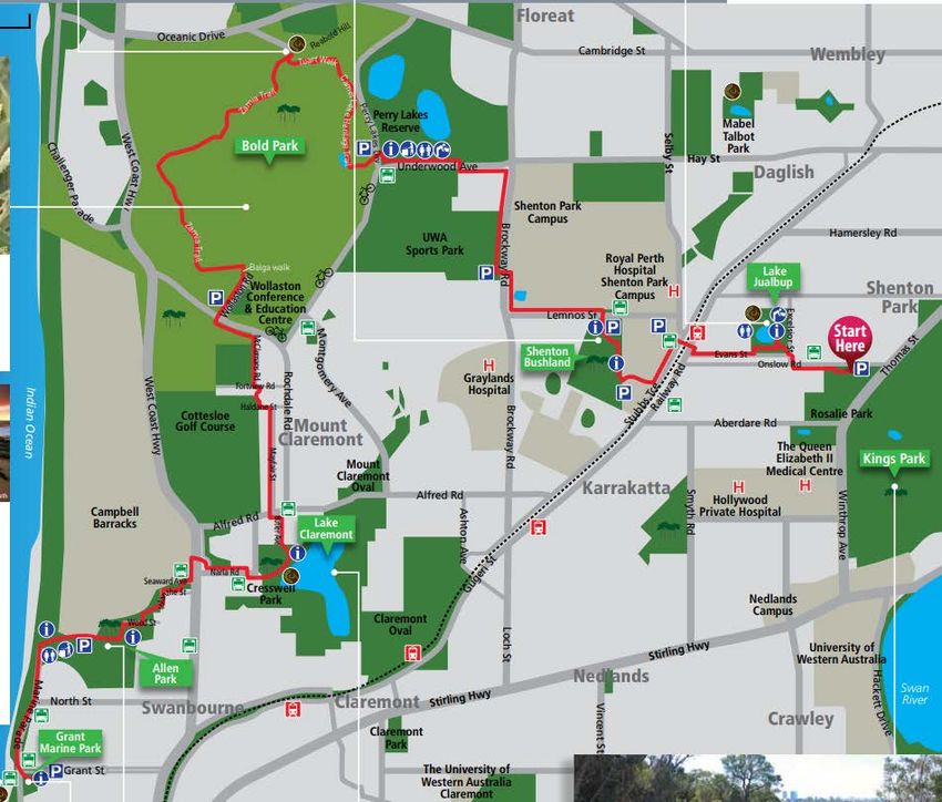
b) Regional trails
Regional trails are major trails or a network of trails that service a population centre or large
regional community, with facilities and services of a standard and appeal that could attract
visitors from outside the region.

Within the Town's boundaries the Whadjuk Regional Trail Network is a network of trails
developed since 2001 in conjunction with the Western Suburbs Regional Organisation of
Councils (WESROC). The purpose of the Whadjuk Regional Trail Network is to link natural
areas and facilitate the appreciation of the land encouraging rehabilitation of natural areas to
extend green corridors within suburbs. v

There are three trails within the Whadjuk Regional Trail Network that run through the Town:

   1. Bush to Beach Trail, running along the southern boundaries of Perry Lakes into Bold
      Park;

   2. Yange Kep Bidi (Wetlands Trail), running from south to north along Herdsman Lake
      in the City of Stirling and looping back to Lake Monger; and

   3. The newly installed Bidi Bo Djinoong ('Trails with views forever') runs along the coast
      and has the potential to extend north and south, creating a coastal network.

                                                6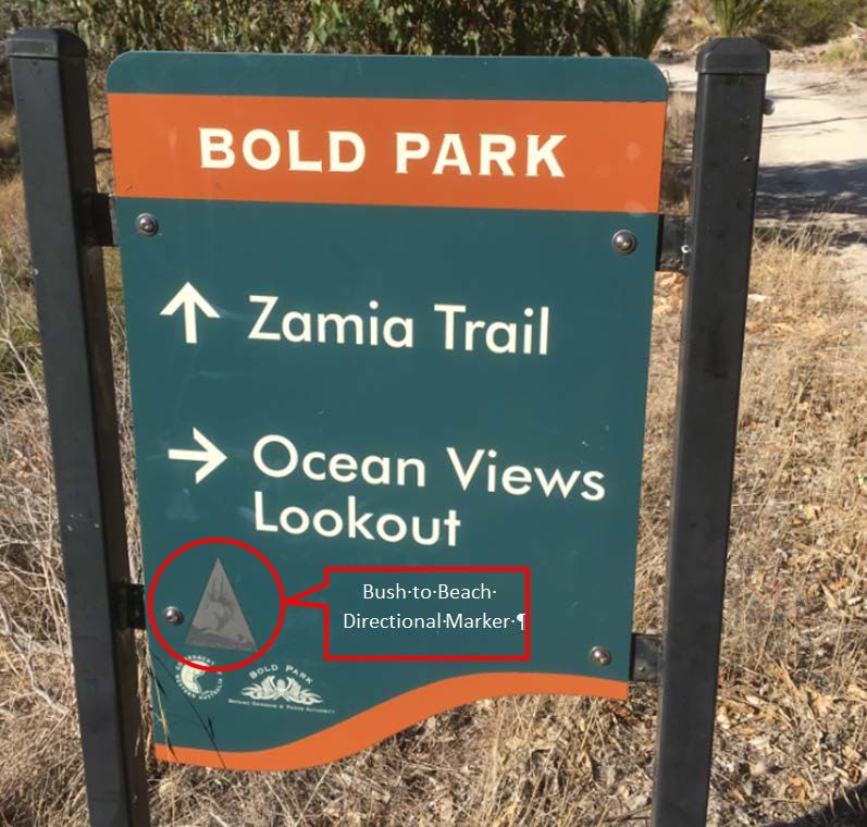
Figure1. Whadjuk Trail Network - Bush to Beach Trail
Source: http://whadjukwalkingtrails.org.au/trails/bush-to-beach/

Figure 2. Whadjuk Trail Network - Yange Kep Bidi (translation 'Wetland Trail')
Source: http://whadjukwalkingtrails.org.au/trails/yange-kep-bidi/

                                                     7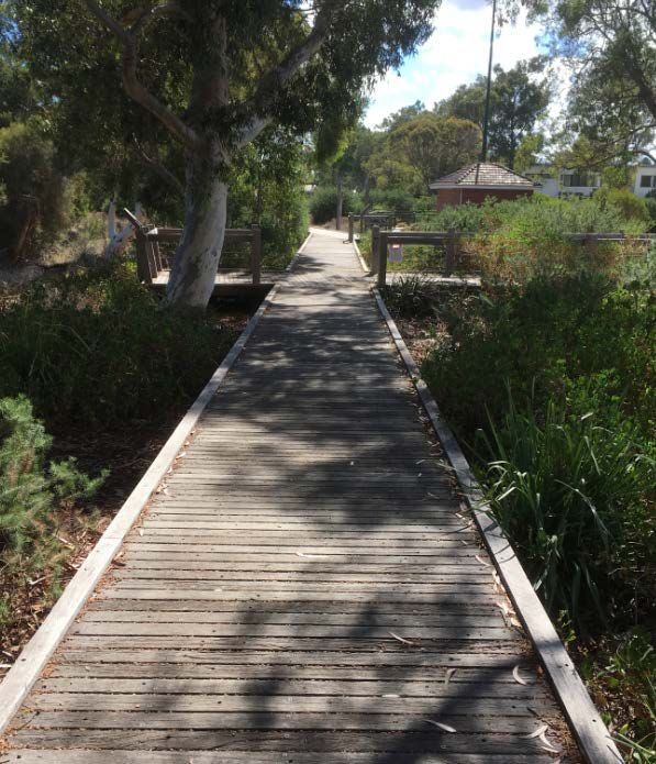
Figure 3. Whadjuk Trail Network - Bidi Bo Djinoong (translation 'Trail with views forever')
Source: http://whadjukwalkingtrails.org.au/trails/yange-kep-bidi/

                                                     8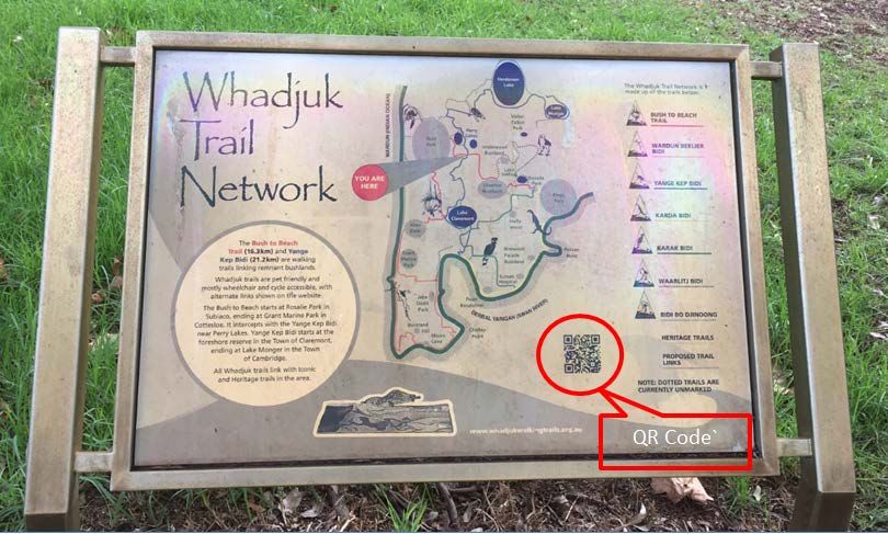
c) Local trails
Local trails service the local community and provide facilities suited to local use. Some
regional and local trail may have potential to be upgraded subject to further development.

Within the Town, there are two existing local trails:
1. The Town of Cambridge Heritage Trail; and
2. The Botanical Parks and Gardens Bold Park Walking and Bridle trail.

Cambridge Heritage Trail

The Cambridge Heritage Trail runs east west through the Town, capturing the Town's
heritage in a series of interpretive signs, allowing residents and visitor to gain an insight into
the Town's past. Currently 23 locations are marked with interpretative signs providing the
local historical background of the area or site.

The Heritage Trail has the potential to be extended even further acting as a link between
local trails and regional trails. The Heritage Trail could also link to the Town's Local
Government Inventory of Heritage Places (currently under review) to create a living
document by displaying information and images on an interactive electronic platform, such
as Google Maps. Mapping of the trail on Google maps will increase the visibility of the trail.

The online promotion of the trail through videos is to be investigated such as the video
compiled for the Whadjuk Regional Trails vi. Short videos can be made for significant
historical sites such as the Leederville Fire Station and Perry Lakes Stadium.

The marking of the trail by installing directional signage as shown in Figure 19 of this
document, Cambridge Trail directional markers, will be investigated, and will be subject to
funding.

Figure 4. Cambridge Heritage Trail
Source: https://www.cambridge.wa.gov.au/Town-Council/Town-Profile/Our-heritage
                                                9
Bold Park Trails
The Bold Park walking trails and one bridle (equestrian) trails are managed by the Botanical
Parks and Gardens Authority (BGPA). Over fifteen kilometres of trails run through the park
and offer visitors beautiful views of the ocean and the city.
The Whadjuk Bush to Beach, Yange Kep Bidi and the Bidi Bo Djinoong regional trails all
intersect with the Bold Park trails.
Figure 5. Botanical Gardens and Parks Authority Trail Network
Source: https://www.bgpa.wa.gov.au/images/boldpark/docs/bp_brochure_v0711.pdf
10Strategy
Selection guidelines for future trails are based on the following:
1. To create local networks and linking places of interest; whilst
2. Allowing for greater public access to green spaces, natural areas and recreational
centres; and
3. Provide greater accessibility and inclusion to meet the needs of the community.
New trails
1. City Beach Trails
The proposed City Beach Trails have been identified with the assistance of public interest
and the City Beach North, Trail 2 subject to Council support will be implemented as the pilot
trail network for the Cambridge trails. Subsequent trails implementation plans can will be
based on the pilot to advance future projects.
The proposed City Beach Trail network will link schools, parks and shopping areas
potentially allowing for greater access to the public open spaces along Bent Park and
Maloney Park in the northern section. The trail will be extended south into the newly
upgraded paths through Templetonia Park connecting with the proposed Sunset coastal
trails, City Beach North, Trail 3. The local trails promote physical activity and create a sense
of community and connectivity.
All the proposed trail routes are based on utilising existing infrastructure and footpaths.
Additional infrastructure could should include benches, water fountains, directional markers
and interpretative signs. Distances range from 3.2km for the shorter route to 7km for the total
longer route.
Map to be removed:
11Figure 6. Proposed City Beach North and South Trails
Replaced with map below indicating the additional trial through Templetonia Park:
12Figure 7. Views along the City Beach Trail past the Empire Village Shopping Centre
2. Wembley Golf Course Trails
The development of walking trails through the Wembley Golf Course were investigated in
2012 and a number of trails have been identified, however, the installation of an underpass
east of the driving range to protect walkers was considered cost prohibitive. The
development of a trail through the Golf Course was supported during public consultation;
however, concerns were raised about the safety of walkers. The installation of internal loops
to the west can be investigated as an alternative. The trails meet the requirements of this
strategy as the trails will open up the use of green spaces to the public allowing for increases
access to Council parks and facilities.
The trails could potentially link to the regional Yange Kep Bidi, the Cambridge Heritage trail
and the proposed City Beach Trail Network. The complete trail distance is 3km; however the
trails can be broken up into smaller internal trails.
13Figure 8. Proposed Wembley Golf Course Trail Network
3. Wembley Wetlands Loop
The proposed Wembley Wetlands Loop trail will link the suburb of Wembley with Lake
Monger and the Herdsman Lake Wetlands. The proposed route will run along the existing
Yange Kep Bidi regional trail. Further detailed investigation will be required as the trail will
cross over into the City of Stirling and support will be required from the City of Stirling. The
approximate distance of the trail is 4km and existing footpaths can be used along the way.
14Figure 9. Proposed Wembley Wetlands Loop
4. Sunset Coast Trail
The proposed Sunset Coast trail will run along the coast from south City Beach linking in
with the existing Bidi Bo Djinoong regional trails continuing north from City Beach to Floreat
Beach along the boardwalk and potentially joining up with the Scarborough trails currently
being developed. An accessible route can be developed along the existing footpaths and
boardwalk and connect with the proposed City Beach trail network, the proposed distance is
2km.
Remove:
15Figure 10. Proposed Sunset Coast Trail
Replace with map below indicating the updated City Beach Trail Network:
16Figure 11. Views along the coastal boardwalk
Linkages
Linkages, connecting points and the looping of trails are important funding considerations.
The creation of networks are prioritised by the Department of Sport as identified during the
development of the regional Whadjuk Trail Network.
A number of opportunities to link various trails have been identified, including cooperating
with neighbouring Councils such as the City of Stirling and the City of Vincent. . Linkages will
enable walkers to combine walking trails to create extended routes, as well as to direct
people to the recognised trails.
The following potential linkages were identified:
1. Extension of the Cambridge Heritage Trail
By extending the existing Cambridge Heritage trails north towards Lake Monger from the
corner of Ruislip Street and Harborne Street, point 8 of the trail, a linkage will be created
between the regional Whadjuk trail, the Yanke Kep Bidi running around Lake Monger and
the Heritage trail the distance is approximately 700m following existing paths.
17Figure 12. Proposed Cambridge Heritage Trail Extension to Lake Monger
2. Perry Lakes Heritage Trail
The Perry Lakes Heritage Trail formed part of the Perry Lakes development, but requires
mapping. The boardwalk runs between the estate and the eastern lakes and provides a
good opportunity to link the Bush to Beach regional trail with the Cambridge Heritage trail.
Interpretive plaques are present proving information on the history and culture of the lakes,
highlighting the importance of the lakes to the local aboriginal people. Recently funding was
obtained through the Perth NRM (Natural Resource Management) to record an aboriginal
story at Perry Lakes. The story will be available on the Cambridge website and will be
available at the site by placing a QR (Quick Response) code sticker on one of the plaques.
The story can be listened to by pointing an iphone camera to the QR code below. Android
phones may require a QR code scanner. The approximate distance is 700m along the
boardwalk and existing paths.
18Figure 13. Proposed Perry Lakes Heritage Trail
Figure 14. View along the boardwalk Perry Lakes Heritage Trail
193. Whadjuk Trail Linkages
Various linkages can be created between the regional trials and will be investigated further;
however, for example, Bush to Beach can be linked to the Cambridge Heritage Trail through
the previously mentioned Perry Lakes Heritage trail. These recommendations received
support during the public consultation and create greater connectivity.
4. Bold Park
Allowing and increasing access to public open spaces are an important aspect of this
Strategy. The western side of Bold Park facilitates limited access; the newly installed Bidi Bo
Djinoong coastal trail runs along the southern border of the park and makes use of the
Westcoast Highway underpass to cross into City Beach. Future linkages can be achieved
through Perry Lakes and along West Coast Highway.
The Bush to Beach regional Whadjuk trail runs through Bold Park along the Zamia trail
signage is shared to limit visual clutter.
Figure 15. Trail co-signage in Bold Park
Implementation
1. Mapping
The trails identified in this Strategy have been mapped internally for the Town's purposes
and will be published on the Town's Intramaps software. A consolidated concept map is
presented in available on Figure 23 page 29 of this document. However, further mapping is
20required in Google maps to create 'open maps' that are available to the public on various
websites.
The mapping layers will be provided to other commonly used mapping databases such as
Trails WAvii where the layers are compatible. All signage will comply with the Town of
Cambridge Style Guide and requirements. Maps will be made available in Pdf. format on the
Town's website and can be downloaded or paper copies can be distributed.
Maps can be made available through electronic devices via Google maps, figure 16
indicates the Bush to Beach Whadjuk Regional Trail on Google maps, or schematic maps
can be produced such as the example provided in figure 17 from the City of Joondalup.
The following information will be made available on the maps:
• The trail route and distances;
• Linkages and loops;
• Public transport options, including bus stops and routes;
• Seating locations and rest stops;
• Water fountains;
• Shops;
• Accessibility;
• Cycling friendly routes
Figure 16. Bush to Beach Trail information available on Google Maps
Source: https://www.google.com/maps/d/viewer?mid=1BjWABjLsh7nEtlfvolqg61y6RVI&ll=-
31.9709049165274%2C115.81157748723149&z=14
21Figure 17. Example of an urban map courtesy of the City of Joondalup
Source: http://www.joondalup.wa.gov.au/Libraries/Documents/Walking_Map_2012.pdf
2. Signage
Walking trail signage is necessary along the routes.
All signage will be designed to:
• comply with Australian Standard (AS)2156 for walking tracks;
• conform with the Town's style guide;
• be corrosive and vandal resistant; and
• be consistent with recognised trail signage where appropriate, for example the
Whadjuk Trails signage.
Visual clutter from signage will be minimal and technology will be embraced, for example the
use Quick Response (QR) codes to provide information where appropriate. QR codes
directly link to a website when a camera of a smart phone, mainly iPhones, is aimed towards
the image. Most android phones require QR reader applications.
22Figure 18. Example of a QR code installed on the Whadjuk Network
Signage will generally be designed and installed to serve one of two functions, detailed
below:
a) Directional markers
Directional markers could be installed along routes and indicates left, right and straight as
shown in figure 19. The markers can be installed directly into the path as shown in figure 20
or on bollards, figure 21.
Where no bollards exist along a walking trail, square recycled plastic bollards will be installed
with the directional markers attached. These bollards are a strong and durable product,
designed to withstand damage from white ants, salt, UV, rot and fire. Similar markers are
currently installed along the Whadjuk Regional Trails.
Installation of directional markers along the main connecting trails such as the Cambridge
Heritage Trail will be investigated and will be subject to future funding.
Figure 19. Proposed Cambridge trial directional markers
23Figure 20. Installed direction maker (Yange Kep Bidi )
Figure 21. Installed direction maker on a bollard (Yange Kep Bidi )
24b) Interpretive signage
Interpretive signage will be located where specific areas of importance are identified to
portray particular information relevant to the location. Interpretive sign designs will include an
information panel detailing the significance of the location, and a way finding panel - for
example, 'You are here'.
Figure 22. Interpretive sign located along Underwood Avenue with QR code
c) Stencilling
The stencilling of directional signage onto hard surfaces is a more cost effective option, but
will require more maintenance in the long term. The implementation of this method will be
investigated for the shorter local trails.
3. Digital wayfinding and information
The use of technology on signage is a very effective way to relay information to walkers
without contributing to excessive signage and expense. As mentioned previously, quick
response codes (QR codes) are well used for walking trails and can be scanned by most
mobile smart phones. By scanning the QR code, information from a website is transferred to
the phone. This allows the use of audio snippets, enabling walkers to enjoy self-guided tours
along each trail. Details about the area, nearby trail attractions and Noongar and local
stories can be incorporated. An example of a QR code is indicated on the photograph above.
4. Marketing
The walking trails will be promoted and accessible on the Town's website, including links to
mapping layer on Google maps and brochures.
25The trails will also be published on the Trails WA website is a recognised location for trail
information within Western Australia. The website is based in WA and links with Tourism WA
providing the best information and exposure to trails with the State.
The promotion of trails through online videos and audio stories will be investigated to provide
additional inform on the trails. It has been shown that short videos increases the likelihood of
people sharing the information on social media further assisting with promotion. The
development of stories and videos will be subject to external funding.
5. Aboriginal Consultation
The heritage, cultural and spiritual connection of Aboriginal people with the land and waterways
is valued and encompassed in the prosed trail networks. High level Aboriginal consultation was
undertaken during the development of this Strategy to identify and recognise significant sites as
well as to identify areas where stories can be linked to trails.
6. Funding and grants
The Strategy provides a clear framework for the development and enhancement of walking trails
within the Town. The funding for implementation of the Strategy will be subject to normal annual
budgetary processes as well as applying for grant funding through Lotterywest and the
Department of Local Government, Sport and Cultural Industries. Grant funding from
organisations such as Be Active WA and disability inclusion grants will be investigated to develop
shorter local trails.
7. Monitor and review
An annual review will be undertaken to determine trail usage, adaptations required and
identification of potential new trails. Trail usage can be determined by visitation data to
websites such as Trails WA or the Town of Cambridge website.
8. Accessibility and Inclusion
Ensuring accessibility of trials were highlighted during community consultation including,
wheelchair and pram access, hand rails, seating and clear mapping indicating difficulty
levels.
Providing greater accessibility and inclusion to meet the needs of the community was
included in the selection guidelines of this Strategy.
Trails will be investigated that cater for limited walking ability with seating or rest options and
shorter, clearly marked routes.
Accessibility and inclusion design principles will be implemented across the projects
including website and mapping designs.
269. Further considerations
During the public consultation phase the following recommendations were submitted and will
be considered during the development of future trails, but could potentially also be
addresses under further infrastructure projects:
a) Wayfinding Signage:
• The installation of wayfinding signage especially along the eastern end of the
Heritage Trail to indicate the train stations, Lake Monger and key destinations
within the Town.
b) Improvement of walking environments:
• Installation of lighting and public art will assist with creating a more walk
friendly environment.
c) Path upgrades
• The widening of paths and safe crossing points were recommended at
various locations; and
• All new trails will be subject to a risk assessment, including walkability and
accessibility valuations.
10. Consolidated Trail Information and Concept Map
The table below indicates the existing trials, proposed trails and linkages. Recommendations
and improvements are noted.
The concept map indicates current trail in the Town of Cambridge, excluding Bold Park trails
as these are managed by the Botanical Parks and Gardens Authority, however linkages to
these trails are encouraged.
27Consolidated Name Trail Classification Description Recommended improvements
Trail Map Length
Reference (km)
Existing Trails
1 Cambridge Heritage 7.4 Walk Town of Cambridge trail Possible extension of trail to create
Trail Cycle linking recognised heritage linkages with regional trails. Mapping of
Heritage places. Individual places are trail on Google Maps for inclusion on
marked. Trails WA website.
2 Whadjuk Trail Network 6.3 Walk Yange Kep Bidi translates to Continue marketing of trails.
- Yange Kep Bidi Cycle 'wetland trail' and this trail An asset register program will be
Bushland links waterholes between the launched through a WESROC project to
experience foreshore and Lake Monger register assets on databases.
Heritage for a total trail length of
Noongar 21.2km (6.3km is within
Town). This trail is complete.
3 Whadjuk Trail Network 6.8 Walk The total trail length is Continue marketing of trails.
- Bush to Beach Trail Cycle 16.3km (6.8km within Town) An asset register program will be
Bushland and as the name suggests, launched through a WESROC project to
experience links bushland from Kings register assets on databases.
Heritage Park through to the coast.
Noongar This trail is complete.
4 Whadjuk Trail Network 6.1 Walk Bidi Bo Djinoong translates Continue marketing of trails.
- Bidi Bo Djinoong Cycle to 'trail with views forever' An asset register program will be
Bushland and this trail links high launched through a WESROC project to
experience vantage points with views to register assets on databases.
Heritage Rottnest Island. This trail is
Noongar complete.
(BGPA) Bold Park Walking 15 Walk The trails are managed by Opening up access to the park to
Trials Limited cycling the Botanical Parks and surrounding residential areas could be
Bushland Gardens Authority. facilitated
experience
Heritage
Noongar
28Consolidated Name Trail Classification Description Recommended improvements
Trail Map Length
Reference (km)
One equestrian,
bridle trail.
Total trails: 41.60
Proposed Trails
5 City Beach Trails Short: Walk The City Beach Trail network Recognition and mapping of trail
3.2km Cycle has been designed to Signposting
Bushland service a large sector of the Marketing
Long: experience community, offering linkage Collecting of stories from Noongar elders
7km Heritage to schools, old age homes, relating to bushland and significant site
Noongar the beach, Empire Village
Additional: and Ocean Village shopping
1.2km areas. The trail also links
with a recognised Aboriginal
significant site, remnant
bushlands and parklands.
6 Wembley Golf Couse 3km Walk Walking trials will open up Previous investigations were
Trails Bushland the internal green spaces to undertaken, however, the installation of
experience the public. an underpass east of the driving range
was considered cost prohibitive. The
installation of an internal loop linking to
the west should be considered.
7 Wembley Wetlands 4km Walk The wetlands loop allows for Investigate save crossings and obtain
Loop Cycle increased access to Lake permission from the City of Stirling.
Bushland Monger and Herdsman Lake
experience (City of Stirling) through
Heritage Wembley.
Noongar
8 Sunset Coastal Trail 2.3km Walk The proposed trail will Trail mapping and marking required
Cycle connect to the existing Bidi
29Consolidated Name Trail Classification Description Recommended improvements
Trail Map Length
Reference (km)
Bushland Bo Djinoong regional trial
experience and will run north along the
coast
Total proposed trails: ±20km
±21km
Proposed Linkages
9 Extension of the 670m Walk Extension of the existing Existing infrastructure in place,
Cambridge Heritage Cycle Cambridge Heritage Trail additional plaque or interpretive sign
Trail Heritage from point 8 ' New Subiaco' required.
north towards Lake Monger
linking with the existing
Yange Kep Regional
Whadjuk trail.
10 Proposed Perry Lakes 680 Walk Majority of trail infrastructure in place,
Heritage Trail Bushland trails requires documentation and
experience formalising.
Heritage
Noongar
Whadjuk Linkages To be Creating linkages between Linkages to be investigated.
determined existing trails.
BGPA Linkages To be Creating linkages between Linkages to be investigated.
determined existing trails.
Total proposed linkages: 1.3km
30Remove:
Figure 23. Consolidated concept map indicating existing and proposed trails
31Replace with map below to include additional City Beach Trail:
32Sources:
i
http://www.roymorgan.com/findings/6123-australian-sports-participation-rates-among-children-and-adults-december-2014-201503182151
ii
https://www.dsr.wa.gov.au/docs/default-source/file-about-us/file-plan-for-the-future/wa-trails-blueprint.pdf?sfvrsn=0
iii
http://www.beactive.wa.gov.au/index.php?id=543
iv
https://www.bibbulmuntrack.org.au/
v
http://whadjukwalkingtrails.org.au/
vi
http://whadjukwalkingtrails.org.au/
vii
http://trailswa.com.au/trails/trail-types/urban-walk/
33DRAFT WALKING STRATEGY SCHEDULE OF SUBMISSIONS- SEPTEMBER 2018
Respondent Support Strategy Comments Theme Response
1 Yes Council to do more to promote Trail promotion Amendment made to draft Strategy - Further promotion of trail
current trails and participation in the to be undertaken
trails
Make trails accessible- providing Provide accessible trails Amendment made to draft Strategy - Examine trail accessibility
wheelchair access, hand rails, options and include accessibility and inclusion in trail selection
walking platforms guidelines
Promote trails via online vide Trial promotion Amendment made to draft Strategy - Investigate creating short
videos and stories to promote trail on social media
2 Yes List names of councils where trails Provide regional context Noted - investigate inclusion in future maps
could potentially link to Whadjuk
regional trails
Support Wembley Golf Course trail Wembley Golf Course Noted
Trail
Support linkage and extension of the
heritage trail Heritage trail Noted
Support mapping trails in Perry Lakes
Perry Lakes Noted
Support directional marking of trails
and interpretive signage. Digital
capability also important Signage Noted and amendment made to draft Strategy
Under trail classification incorporate Trail categories Amendment made to Strategy - Accessibility and inclusion
accessibility and pram friendly as incorporated under trail classifications and selection guidelines
trail categories
Show how walking trail strategy links Amendment made to Strategy
with the Strategic Community Plan.
3 Neither support or Cater for those with limited walking Provide accessible trails Noted - Investigate seat and hand rail installations during trail
object ability- place seats every 150m with development
rail to assist with sitting and
standing. Seats could be placed at
the beginning 2km or end 2km of aDRAFT WALKING STRATEGY SCHEDULE OF SUBMISSIONS- SEPTEMBER 2018
Respondent Support Strategy Comments Theme Response
trail not entire length to cater for
those that can't walk as far.
Show seat on maps and included the Mapping Noted - Investigate inclusion of information in future mapping
distances between seats
Include distances on maps for short Mapping Noted - Investigate inclusion of information in future mapping
sections of trails to assist those that
can only walk short distances
4 Yes Include good directional signage Signage Amendment made to Strategy - Include directional signage
along trails
Provide nearby public transport Signage Noted
options on signage in case walkers
find the trail too long to do in one
attempt
5 Yes Support strategy in general Support Noted
6 Neither support or What is the cost of the strategy? Funding of strategy Noted - Investigate cost of implementing stages of strategy and
object include in future budgets, investigate and apply for external
funding
7 Yes Support strategy Support Noted
8 Yes Develop a booklet with maps Mapping Amendment made to Strategy - Maps to be placed on the
including trail distances and notable Town's website in pdf format and can be downloaded
features
9 Neither support of Strategy should focus on connecting Connect trails to public Amendment made to Strategy - Investigate opportunities for
object trails to public transport, especially transport connecting trails to public transport
West Leederville and Leederville
train stations.
Need wayfinding signage at train Way finding signage Amendment made to Strategy - Investigate way finding signage
stations as they are key entry points at train Leederville and West Leederville train stations
to the Town. Need to identify key identifying key destinations in the Town. Possible inclusion in
Town assets eg's. future infrastructure projects.
-wayfinding signage to Lake MongerDRAFT WALKING STRATEGY SCHEDULE OF SUBMISSIONS- SEPTEMBER 2018
Respondent Support Strategy Comments Theme Response
from Leederville train station
-wayfinding signage on the south
side of Railway Pde between
Northwood and Kimberly Streets
pointing to key destinations in the
Town. Also need an obvious crossing
point here.
Improve dull and hostile walking Safe crossing point Noted - proposals to be considered in future Infrastructure
environments with lighting or public projects
art eg: Investigate an obvious crossing point at this location -
-the wall along Southport St: public Amendment made to Strategy
art Investigate options to activate environments - Amendment
-Vincent St/Lake Monger Dve made to Strategy
underpass, dark: lighting, public art
-Vincent St West, dark: lighting; Activate dull and hostile Noted - alternative options to be investigated and safety
major route for people walking from pedestrian environments measures considered
West Leederville to Leederville Wembley Golf Course
Trail
Wembley Golf Course trail not
practical
10 No Do not support the Wembley Gold Wembley Golf Course Noted
Course trail- not safe, liability issues Trail
11 Neither support or Use durable materials in trails and a Materials Noted - to be investigate under Infrastructure projects -
object variety of walking surfaces which Outside Walking Strategy Scope
moderate temperature better
12 Neither support or Create a wide, uninterrupted Wembley Golf Course Noted - Investigate trail options at Wembley Golf Course
object walking/running track with seats,
water stations and distance markers
at Wembley Golf Course. Promote as
a challenge
13 Yes Prefer circular trails/walks- easier if Circular trails Noted - Emphasis placed on connectivity in the Strategy by
trails start and finish at the same identifying circular routes
point to avoid transport issues in
getting back to the starting point
Include public transport info toDRAFT WALKING STRATEGY SCHEDULE OF SUBMISSIONS- SEPTEMBER 2018
Respondent Support Strategy Comments Theme Response
connect the end of long walks back Public transport Noted
to the start if not circular information
Avoid maps like those produced by
the City of Joondalup referred to in Provide regional context Noted
the strategy- they don't provide
sufficient context
14 Yes Widen the path along Oban Rd Path widening Noted - Investigate path widening at this location through
connecting Kapinara Primary School Infrastructure projects
to Empire Village- currently too
narrow Safe crossing point Noted - Investigate a safe crossing point at this location during
Need a safe crossing point across future trail establishment
Oban Rd to Beecroft Park
15 Yes Support for the North City Beach North City Beach Trails Amendment made to Strategy - Investigate addition of a third
Trails City Beach trail through upgraded Templetonia path network
Include the upgraded path through
Templetonia Park as link to the
Floreat Beach.
Increased linkages supported
between Durston/Empire/Chipping
to the Golf Course and making use of
the ocean views to the west.You can also read