Development in Australian bushfire prone areas
←
→
Page content transcription
If your browser does not render page correctly, please read the page content below
Issue 05 • October 2019
Environment                                                                            acumen.architecture.com.au/environment

                                                                                                                        ISSN 2651-9828

Development in Australian bushfire
prone areas
Nigel Bell

Cover image. Bushfire rebuild after the 2013 loss of the original pole-frame timber house, Blue Mountains, NSW, by ECOdesign Architects
(Image: Nigel Bell)

Abstract
Bushfire has long been a part of Australian landscape ecology and mythology, but climate change is now
driving an increase in fire emergencies and a greater regulatory response. There are new levels of bushfire
frequency, severity and unpredictability across much of Australia – and indeed globally. The previous bushfire
season pattern is no more, with record heat and drying creating extreme fire weather patterns. The risk is
spreading from the rural and urban-bushland interface, across more of the landscape and into towns and cities.
Increasingly, an expansion of development types in bushfire prone areas — not just dwellings — will need
to address bushfire risk from a mandated bushfire assessment upfront through to a regulated planning and
construction response. The National Construction Code with state/territory variations now calls up the bushfire
Australian Standards and the NASH Standard (steel) as Deemed-to-Satisfy alternatives.
This Note outlines the impact of climate change on bushfire conditions in Australia and the ensuing regulatory
imperatives for planning and construction within bushfire prone areas. It provides an overview of bushfire attack,
the Fire Danger Index, the regulatory framework plus development issues and concerns currently applicable
to states and territories. Planning and design considerations, including siting and landscaping concerns, are
not covered by this note and will be the subject of a separate note.

                                                                                          Environment - ISSUE 05 OCTOBER 2019
                                                                                                                            1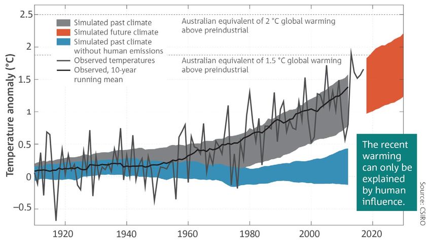
Introduction
From indigenous ‘fire-stick farming’ (mlakidang, 2014)      Standards related to bushfire issues:
to proactive prescribed burning and emergency back-
burning, fire has had many uses in the Australian           AS 3959:2018 Construction of buildings in
context. But the balance between bushfire prevention        bushfire-prone areas
and suppression is changing, along with the likely          AS 5414—2012 Bushfire water spray systems
consequences of extreme bushfires (Sharples et al,
                                                            ABCB, Private Bushfire Shelters Performance
2016). Bushfire frequency and severity have increased
                                                            Standard 2014
markedly in recent decades, burning places and
regions previously thought immune ie Wet Tropics            NASH Standard Steel Framed Construction in
Queensland and the Tasmanian Wilderness World               Bushfire Areas 2014
Heritage area (Earl et al, 2019).
Australia leads the world in fatalities from bushfires
(Blanchi et al, 2013), yet the massive scale of           Bushfire danger
building loss in California in late 2018 dwarfs all
previous fires (Bowman et al, 2018). Climate change       and climate change
predictions indicate that mega-bushfires may become
the new norm in many areas, overwhelming many             Australian vegetation has grown and adapted to
communities’ and agencies’ ability to mitigate,           bushfires for tens of thousands of years, to become
evacuate or respond effectively. Enhanced bushfire        the most flammable landscape on Earth (ATSE, 1999).
risk is but one human, environmental and financial        The extent, frequency and intensity of future bushfire
consequence of climate change.                            events is on the rise. Research has shown that
                                                          climate change is bringing on extreme weather
The devastating Victorian 2009 Black Saturday             events with lengthened fire seasons since around
bushfires and subsequent Royal Commission marked          1970 (Clarke et al, 2012; Climate Institute, 2016;
the change in regulatory response across Australia        Climate Council, 2018).
(2009 Victorian Bushfires Royal Commission,
2010a and 2010b). New Australian Standards were
developed (see text box below), and the existing main     The extent, frequency and intensity of future
standard AS 3959-2009 was upgraded and further            bushfire events is on the rise.
revised in 2018. The National Construction Code
(NCC) has mandated application of these standards
across Australia, with most states and territories        The average temperature has risen across the
introducing localised changes to their planning           continent by almost 10C since Federation (Figure 1),
regimes for greater bushfire protection. While NSW        while rainfall in many areas has dramatically fallen
has empowered the Rural Fire Service to become            from long-term averages. All but one of the ten
the de facto consent authority in bushfire-prone areas,   hottest years on record have occurred since 2005
other states have implemented bushfire overlays for       (Bureau of Meteorology, 2019) (Figure 2). Widespread
everyday planning practices or have left the matter       warmer and drier weather has moved from severe
within building control, as outlined later. However,      through to catastrophic weather conditions, including
every new bushfire with significant loss of life and/     that which promotes bushfires. In summary, the
or property leads to moves for further development        areas affected by bushfire have broadened, the fire
restrictions with consequent cost and approval            season has extended and the opportunity for hazard
difficulties placed directly on the applicant or          reduction between fire seasons is much reduced
developer — without a considered holistic approach.       (Climate Council, 2018; Hamilton, 2019).

Environment – ISSUE 05 OCTOBER 2019
2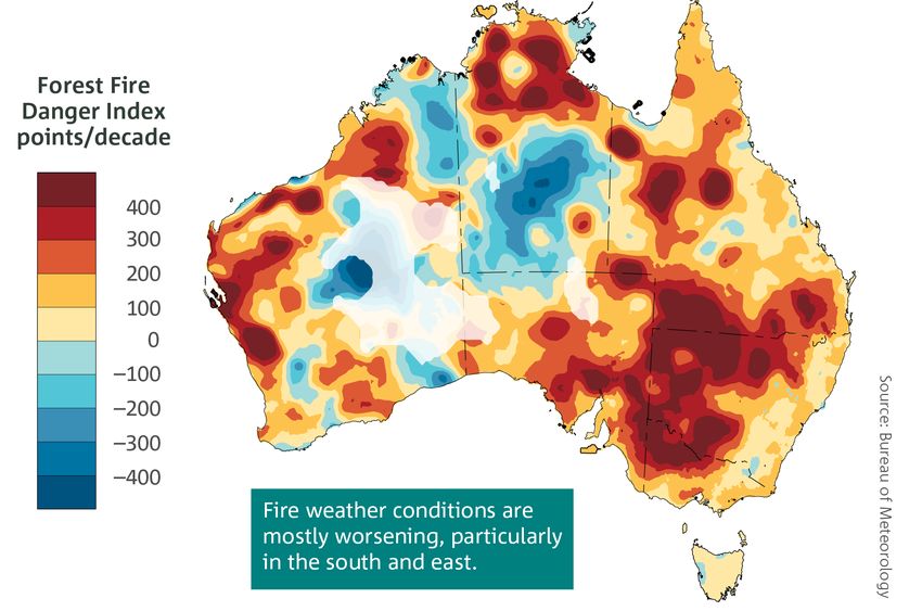
Figure 1. Future climate: Australia’s average temperature relative to 1861–1900 (Image: Commonwealth of Australia, 2018).
Reproduced by permission of Bureau of Meteorology, © 2018 Commonwealth of Australia.

Figure 2. The mean temperature in December 2018 to January 2019 showing most of Australia was the hottest on record.
(Image: Bureau of Meteorology, 2019). Reproduced by permission of Bureau of Meteorology, © 2018 Commonwealth of Australia.

                                                                                  Environment – ISSUE 05 OCTOBER 2019
                                                                                                                    3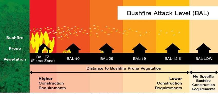
Forest Fire Danger Index (FDI)
The Forest Fire Danger Index (FFDI – often shortened               While an increase in the FDI in recent decades
to FDI for simplicity) is the regulatory starting point            (Figure 3) has also seen an increase in the length of
in assessing bushfire risk. This index estimates                   the fire-weather season, there is also much year to
the fire danger on a given day based on records of                 year variability, brought on by another climate change
dryness (taking into account rainfall and evaporation)             factor: the El Niño southern oscillation (warming)
plus observations of temperature, humidity and wind                and La Niña (cooling) years, shifting global weather
speed.                                                             patterns of extreme rainfall and cyclones in one area,
                                                                   and extreme drought in another across the continents.
The consequence of changing weather patterns
from climate change on bushfires is seen in studies                Nevertheless, heightened heat, lower humidity and
showing a rapid increase in the FDI from 1973 across               drought with stronger wind patterns contribute to
Australia, accelerating since the late 1990s (The                  high/higher FDI values with consequences for the
Climate Institute, 2016). By 2050, compared to the                 number and intensity of bushfire days. This is the
weather from 1980-1999, extreme fire weather days                  primary starting point for assessment of bushfire
are projected to grow by 10 per cent to 50 per cent                hazard and risk in Australia. New and higher FDIs
(with low growth in greenhouse gas emissions) and                  are likely to eventuate across all jurisdictions (even
by 100 per cent to 300 per cent if a higher greenhouse             where resisted), which in turn will lift the required
gas emission scenario prevails (The Climate Institute,             bushfire development response.
2016).

Figure 3. Trend in the annual sum of Forest Fire Danger Index, 1978–2017 showing (yellow to red) the increase in fire weather season
(Image: Commonwealth of Australia, 2018). Reproduced by permission of Bureau of Meteorology, © 2018 Commonwealth of Australia.

Environment – ISSUE 05 OCTOBER 2019
4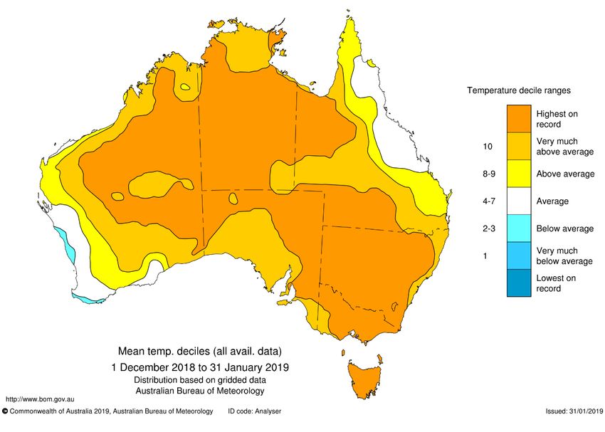
Some costs of bushfires                                      Bushfire attack
While Aboriginal peoples lived with bushfires and            The Black Saturday bushfires eliminated the previous
used controlled burns to their hunting advantage,            mantra that ‘buildings save people and people save
the early white settlers learned to fear them                buildings’, due to what was then an unprecedented
(Gammage, 2011). This fear remains a primary                 fire. Fire authorities are now promoting every
emotion for many today, although too few perceive            household to have an individual written Bushfire
that they are at risk from bushfires despite objective       Plan, with advice to leave early under the threat
evidence (Brown, 2013). Social research has shown            of a bushfire. Some jurisdictions are now seeking
that long-term emotional damage for those who                to evacuate people (and pets) from critical areas in
lived through severe fire events may outlast the             advance of the fire front (when the FDI is > 50), plus
physical damage and loss (Every, 2016; University            containment of the fire from the air (at great expense
of Melbourne, 2016). Towns may be slowly rebuilt,            but better human safety). Human safety concern has
but emotionally secure lives and communities, not            come to dominate policy and planning in the last
as readily.                                                  decade, with acceptance that this means a greater
                                                             loss of buildings, livestock, native flora and fauna.
Since Australian records commenced in 1851,
bushfires have accounted for more than 800 deaths,           With evacuations in advance of the fire front, an
with total accumulated cost estimated at $1.6 billion        increased ‘house to house’ fire loss such as in
(Blanchi et al, 2013). Historically, Victoria has suffered   Canberra 2003 is to be expected (Blanchi & Leonard,
                                                             2005). With fewer people to extinguish building ignition
the worst bushfire events (loss of life and property),
                                                             points, burning embers on combustible decks, sills
while Queensland has recently experienced major
                                                             and doormats can fester to quickly become
rainforest fires (Cox, 2018) and Tasmanian World
                                                             unstoppable house fires. The influence of fences
Heritage regions burned for the first time in 1000
                                                             and garden vegetation to minimise or exacerbate
years in late 2018 and early 2019 (Earl et al, 2019).
                                                             fire attack and spread has come under greater scrutiny
Studies have shown that Victoria has suffered the
                                                             recently, but to date has escaped regulation due to
worst from civilian fatalities (65 per cent) and house
                                                             the vast extent of variables.
losses (57 per cent), followed by NSW (14 per cent
and 19 per cent respectively) and Tasmania (9 per            Mechanisms of bushfire attack
cent of fatalities) (ABCB, 2019).
                                                             Buildings are damaged and destroyed through five
Drought, hail, severe storms, flooding and cyclones          mechanisms of bushfire attack, most often through
have cost more than bushfires for insurance                  combinations that cause ignition and burning. Once
companies, yet of these natural disasters bushfires          ignited, there is every likelihood of building loss
have led to the greatest loss of life. Consequently,         unless there is human intervention at the critical time.
insurance premiums in bushfire-prone areas have
                                                             Ember attack: Burning ember attack can occur before,
not yet reflected the individual bushfire hazard
                                                             during and after the main fire front has passed through
and risk. Nevertheless, those seeking to build within
                                                             (and sometimes from kilometres away). Embers
bushfire-prone areas become acutely aware of the
                                                             can ignite a building through direct contact with
financial impacts of bushfire building regulations
                                                             combustible material; enter through small gaps in the
which can easily add $100,000 or more in construction
                                                             building structure (ie under roof cladding/sheeting);
costs in higher risk level areas (AAMI, 2016).
                                                             through broken glass (thereby igniting the building
Increasingly, only products and assemblies fully
                                                             from the inside) or from the ignition of materials nearby
tested to the bushfire standard are accepted by              (ie combustible deck, garden wood mulch, timber
regulators, and these offer limited choice.                  fence). Ember attack is the primary cause of house
                                                             loss (around 80 per cent), with the weakest link
                                                             often being timber decks and/or verandas, followed
                                                             by sparks entering into roof cavities, most typically
                                                             from gutters and at the eaves.
                                                             Radiant heat: This may arise directly from the fire front
                                                             or combustion nearby (ie a garage/carport or adjacent
                                                             house). It may super-heat building components
                                                             (inside or outside) so they ignite from flammable gases,
                                                             or from drying the building materials so they become
                                                             more readily flammable. The greatest bushfire risk
                                                             to human life and wellbeing is exposure to radiant
                                                             heat in the open, followed by exposure to radiant
                                                             heat when trapped within burning buildings.

                                                                           Environment – ISSUE 05 OCTOBER 2019
                                                                                                             5
Flame contact: This risk is influenced by the nearby Measuring risk – Bushfire Attack Levels
fuel load, slope and fire intensity; hence siting of (BALs) ratings
buildings and combustibility of building materials
is crucial, as is avoiding fine fuels (ie garden, mulch) From 2009, the Australian Standard AS 3959
and nearby items (ie decks, fences and buildings) Construction of Buildings in Bushfire-Prone Areas
close to the building. Approximately 85 per cent has adopted six BAL ratings as a means of assessing
of house losses occur within 100 metres of bushland a building’s potential exposure to bushfire attack
(Leonard, cited within Victorian Bushfires Royal (Figure 6). The BAL is largely based upon radiant heat
Commission, 2010b). flux expressed in kW/m2, with each step representing
a higher risk, from 12.5kW/m2 (BAL—12.5) through
Convective heat: Hot air from an approaching
to 40 kW/m2 (BAL—40).
bushfire pre-heats and dries out both vegetation
and buildings, creating hot gases that increase Up to BAL—29, most common building materials and
the likelihood of ignition. construction is likely to be acceptable. At BAL—40 the
range of acceptable materials and components gets
Strong winds: Bushfire weather is associated
more restrictive and expensive (tested to AS 1530.8.1,
with strong/extreme winds. Aside from winds
although the generic roofing solutions within the AS
driving ember attack and spotting, the internal/
3959 Appendices have not been tested but are still
external pressure difference also creates conditions
accepted).
for building failure (ie falling branches, glazing
failure, roof dislodgement). And bushfires create For development in BAL—FZ (Flame Zone), subject
their own extreme weather (Victorian Bushfires to intense embers, heat, flame and more, all
Royal Commission, 2010a and 2010b). materials and components must be fully fire-tested
to AS 1530.8.2 if the building is sited less than
Assessing the level of bushfire attack – FDI ten metres from the edge of classified vegetation.
At the time of writing this was an issue, as some
As discussed, the FDI is an overall index that
jurisdiction’s product testing to AS 1530.4 with
approximates the potential fire danger – and it’s
acceptable FRLs (Fire Resistance Levels) were
increasing. The current bushfire regulations
not deemed comparable or acceptable without
(AS 3959:2018) are conservatively based on 2009
submission of an NCC Alternative Solution expert
FDIs, rather than responding to the higher risk
report. The development consequence is restricted
scenario already established (Figure 5). In NSW,
choices, significantly higher building costs (especially
the Rural Fire Service (RFS) has sought to raise the
glazed components), approval delay and considerable
FDIs to 100 across the state (except alpine regions).
uncertainty. This is a serious problem for industry,
as regulators minimise their liability.
Figure 4. Bushfire Attack Level (BAL) rating (Image courtesy of Skydome Hunter Coast, 2019)
Environment – ISSUE 05 OCTOBER 2019
6State / region FDI
Australian Capital Territory 100
New South Wales
(a) Greater Hunter, Greater Sydney, Illawarra/Shoalhaven, Far South Coast and Southern Ranges fire 100
weather districts
(b) NSW alpine areas 50
(c) NSW general (excluding areas named above) 80
Northern Territory 40
Queensland 40
South Australia 80
Tasmania 50
Victoria
(a) Victoria alpine areas 50
(b) Victoria general (excluding alpine areas) 100
Western Australia 80
Figure 5. Current values for FDI (Source: AS/NZS AS 3959-2018 Table 2.1; © Standards Australia Limited. Copied by Australian Institute
of Architects with the permission of Standards Australia and Standards New Zealand under Licence 1910-c014)
BAL Description
BAL—LOW There is insufficient risk to warrant any specific construction requirements.
BAL—12.5 There is a risk of ember attack.
BAL—19 Ember attack plus burning debris ignited by windborne embers, plus radiant heat.
BAL—29 Increasing levels of ember attack and burning debris ignited by windborne embers, plus
increased radiant heat (19 – 29 kW/m2).
BAL—40 Much increased risk from ember attack and burning debris ignited by windborne embers,
plus higher level of radiant heat and some likelihood of direct exposure to flames (29 - 40
kW/m2).
BAL—FZ (Flame Zone) Highest risk of ember attack plus direct exposure to heat (> 40 kW/m2) plus flames from
the fire front. The standard notes that Authorities may require additional measures, other
than construction requirements.
Figure 6. BAL ratings (Source: AS/NZS AS 3959-2018 Appendix G3 [paraphrased]. © Standards Australia Limited. Copied by Australian
Institute of Architects with the permission of Standards Australia and Standards New Zealand under Licence 1910-c014)
Environment – ISSUE 05 OCTOBER 2019
7Procedure for making a bushfire attack Regulatory controls
assessment
Every state and territory addresses bushfire
There are five steps in making a Method 1 (everyday)
management somewhat differently – although there
assessment within AS 3959:2018. Increasingly, this
is one national Australian Standard AS 3959:2018,
should be made by trained and accredited bushfire
which is universally called up within the NCC. The
assessors only (Refer Acumen note: Projects in
NCC also accepts that the steel-framed NASH Standard
bushfire-prone areas).
for Steel Framed Construction in Bushfire Areas meets
1 Determine the Fire Danger Index (FDI) the Deemed-to-Satisfy requirements.
2 Determine the vegetation classification(s) AS 3959: 2018 Construction of buildings
3 Determine the distance of the building from in bushfire-prone areas
classified vegetation
This revised and updated standard (from 2009)
4 Determine the effective slope (which holds is applicable for all bushfire-affected construction
the classified vegetation) from 1st May 2019, but with some state variations
5 Determine the BAL rating from AS 3959 charts. as outlined below.
While the scope of the standard has remained
Construction requirements from AS 3959:2018
constant over the years, many elements have grown
(plus state variations where relevant) are then
in regulatory complexity including the method of site
applied to the project. All these steps require
assessment requirements, vegetation classification,
some specialist knowledge.
shielding, enhanced requirements for fire testing
Method 2 within AS 3959 uses highly complex (to AS 1530 as outlined below), enhanced glazed
formulae and should only be used by appropriately components, what constitutes approved /excluded
accredited assessors (see note on assessors below). materials, and the requirements for fire testing.
It includes wind speed, more detailed vegetation and
fuel load, flame length, flame width, the elevation AS 5414—2012 Bushfire water spray systems
of the receiver, radiant heat flux, view factor, and
Commercial and industrial buildings have utilised
atmospheric transmissivity.
sprinkler systems (including externally over windows
and openings) to AS 2118.4, but systems designed
against bushfire attack raise other issues. These
Note on assessors and providing advice include the system design (the technical capability
and/or accreditation), operation (manual/automatic),
The Australian Institute of Architects strongly duration, extent/limits of water supply (when
recommends that an accredited bushfire-hazard reticulated mains have failed), nozzle type location
assessor should be engaged, rather than and spacing (with diverging views on this), type of
architects providing advice outside their area pump (ie petrol, diesel), spray type and location to
of expertise and insurance cover (Refer Acumen provide some protection against ember attack plus
Practice Note: Projects in bushfire-prone areas, limited radiant heat flux.
Australian Institute of Architects, 2018). The It is significant that there is no regulatory assistance
Fire Protection Association of Australia (FPAA) or concession for installing a complying system
lists practitioners who have qualified through (ie dropping one BAL level as for shielding within
graduate studies in Bushfire Planning and AS 3959). The scope of the standard also specifically
Design (BPAD) to become accredited bushfire states that it’s applicable only up to BAL—19
practitioners (note, at different levels of (< 19 kW/m2). Consequently, this standard is of
expertise). Practitioners need to be wary of reduced utility. Nevertheless, installation of a suitable
using absolute terms implying bushfire safety, water spray system remains a practical retrofit solution
to enhance bushfire safety.
rather than cautioning that a project designed
and built to the applicable BAL rating has fire
defences built-in to that level. Words like ‘fire
resistant’ are more appropriate than terms such
as ‘fire-safe’, ‘fire bunker’, ‘fire refuge’ and the like.
Environment – ISSUE 05 OCTOBER 2019
8Performance Standard for Private Bushfire NASH Standard Steel Framed Construction
Shelters 2014 in Bushfire Areas 2014
The Australian Building Codes Board determined that The National Association of Steel-Framed Housing
this would become an advisory document, rather than (NASH) provided research evidence and fire
a mandated standard. While the risk mitigation of a engineering principles to justify NCC/BCA acceptance
properly designed and built shelter was recognised, as an equal solution to that of AS 3959. This standard
the fire variables were deemed too great to provide can be used for all BAL levels up to BAL—FZ.
more than advice. It requires that a fire engineer
The key difference to all other approaches is that it
certify such structures as an Alternative Solution
requires fully non-combustible construction with all
under the NCC to address the following summarised
steel framing (underfloor, floor, walls and roof) that
criteria (Figure 7).
conforms to NASH Standard for Residential and
At the time of writing, there were very few ready-made Low-Rise Steel Framing, Part 1: Design Criteria, or
or prefabricated private bush fire shelter options Part 2: Design Solutions. It, therefore, permits any
on the market due to cost, difficulties of construction non-combustible claddings and linings on the basis
and approval, plus questions of ongoing liabilities. that any fire embers will not cause ignitions due to
However, Victoria has accepted conforming shelters the steel framing.
if written into ongoing property and maintenance
agreements, giving a one-step reduction in the BAL
rating requirements for the dwelling.
Design component Acceptance criteria
Location Distance to the dwelling, boundaries, adjacent structures
and other fuel sources.
Access from the dwelling to the shelter Travel distance, maximum 20 metres.
Access pathway between the dwelling and the shelter Pathway to be unobstructed, non-combustible, one-metre
wide and not a hazard to travel.
Provision of tenable conditions within a shelter A minimum 60 minutes occupation, with minimum heights
and volume per person, a tenable interior environment
(temperature, plus interior surface temperature), minimum
air toxicity (off-gassing), smoke sealing and ventilation.
External envelope Construction materials, structural design, size of openings,
acceptable bushfire test regimes.
Access doors or hatches Size, width and test regimes for access doors or ladders,
plus maintenance of access/egress after a fire.
Signage Specified size and wording of signage outside and in.
Capacity to assess external conditions Specified maximum and minimum size of viewing window.
Maintenance A maintenance manual is mandated.
Figure 7. Acceptance Criteria summary (in part) from Table 2.4 of the Performance Standard for Private Bushfire Shelters (ABCB, 2012)
Environment – ISSUE 05 OCTOBER 2019
9State and territory bushfire requirements
Under Australia's emergency management While private bushfire shelters may be accepted if
arrangements, state and territory organisations are certified by ‘an appropriately qualified practitioner’
the primary agencies responsible for bushfire safety. (such as a fire engineer), they are not accepted as
The degree of development integration (or otherwise) an alternative to full building compliance with AS 3959.
varies enormously. The information below gives a
Accredited bushfire practitioners (and their clients)
brief overview of the varying approaches between
complain about the lack of certainty regarding the
states and territories at the time of writing.
RFS overview, in that many consultants’ bushfire-
Australian Capital Territory (ACT) attack assessments are overruled. While local
government is obliged to forward all development
Being ‘the bush capital of Australia’, nearly a quarter applications past BAL—29 to the RFS for comment
of all Canberra’s housing is within a defined Bushfire (with no timetable), councils deal with compliance.
Prone Area (BPA), along with all rural ACT. At the As a result, in higher BAL situations, many applications
time of writing, the ACT Emergency Services Agency are caught between jurisdictions, experts, interpretations
stated that government was considering mandating and construction matters – all with significant costs.
that all buildings within a BPA must conform to AS
3959 requirements, rather than just the rural housing Northern Territory (NT)
standard.
Bushfires and grassfires are common across
Usefully, the ACT Government (Advisory Note 1601) the NT, but typically in sparsely settled areas with
has mapped all bushfire-affected suburbs and limited water supplies. Hence, bushfire-management
provided every property with a BAL rating upfront. responsibilities are split between the property owners
The Territory Code contains this information within and the NT Fire and Rescue Service. From November
the Single Dwelling Housing Development Code 2016 the Bushfires Management Act provides a
and Precinct Maps and Codes. Following that, the response to mitigation management and suppression
application of construction requirements from of bushfires outside of the Emergency Response Area
AS 3959:2018 applies. Since the lessons from the of cities and towns. Total fire bans exist all year round
many ‘house-to-house’ fires in the 2003 Canberra for Darwin and nearby, plus within a 50km radius of
bushfires, there are now specific warnings about Tenant Creek, Katherine and Alice Springs. The relevant
facing gas bottle pressure-relief valves and meters jurisdiction assesses the risk of bushfires across large
away from combustibles, plus vegetation clearance swathes of grassland and savannah, but this does not
requirements. extend to specific planning and construction controls
for housing (or other building typologies).
New South Wales (NSW)
Queensland
Development within NSW has been primarily
controlled by the NSW Rural Fire Service whose New controls were introduced following the 2018
regulatory requirements are more onerous and State Planning Authority’s Natural Hazards, Risk
comprehensive than those of AS 3959:2018. The draft and Resilience – Bushfire State Interest guidance
2019 Planning for Bush Fire Protection has widened material and the QFES draft Planning for Bushfire
its remit to bushfire planning controls over Special Resilient Communities technical document. The newly
Fire Protection Purpose development (being schools, developed state methodology (Leonard et al, 2014)
hospitals, aged care and tourist accommodation arises from highly detailed vegetation mapping,
etc), plus bushfire-planning controls on commercial, plus a methodology that informs bushfire mitigation
industrial, tertiary institutions (Class 5 to 8) and and preparation actions across the state.
assembly buildings (Class 9). Multistorey buildings,
Brisbane City Council has retained the previous
strategic planning and master-planning are captured
system where designated bushfire-prone areas
within the broad remit on a case-by-case basis plan.
require a Bushfire Management Plan and a site-
Intensification of residential use is not accepted for specific Bushfire Hazard Assessment. The Hazard
properties past BAL—29, precluding many property Assessment uses a weighting scorecard around
options and severely limiting many proposed vegetation type/proximity, slope and aspect, to
developments in bushfire-prone areas. Garages determine whether the risk is high, medium or less
and carports within six metres of a dwelling must be – plus a required separation distance of 100 metres
constructed in accordance with the NCC and AS 3959. from the edge of the asset to the vegetation hazard.
Environment – ISSUE 05 OCTOBER 2019
10South Australia (SA)
Current SA bushfire mapping has three grades: Where applicable, the Bushfire Management Overlay
high, medium and low. Proposals to develop property (BMO) to a Planning Scheme requires a statement
within high-bushfire-risk areas are assessed against of bushfire management objectives plus details
the bushfire-protection planning provisions of the when the requirements apply. BMO permits are
relevant local area development plan, including required to subdivide land, dwellings and higher-risk
a referral to the Country Fire Service. All new development types. Building permits must include
dwellings or tourist accommodation are assessed compliance with all bushfire-protection measures.
for compliance with having a dedicated water supply Victoria has produced the only comprehensive guide
(22,000L), enclosure between ground and floor, to landscaping in bushfire-prone areas, the CFA’s
be setback 20 metres from combustible vegetation, Planning for Bushfire Victoria: guidelines for meeting
be located to minimise risk, and have acceptable Victoria’s bushfire planning requirements, 2012.
roads and tracks for fire fighting vehicles. The SA Planning and building requirements include bushfire-
Country Fire Service Development Assessment hazard assessments in accordance with AS 3959,
team has two sections: Residential and Commercial to broaden landscape assessments of the locality
(for development > 500m2).
to more than 150 metres from the site. A bushfire-
In addition, new buildings are assessed against management statement is required to explain how
the provisions of the building regulations including the development meets the planning requirements.
the Ministers Specification to ensure they are Vegetation management must now conform to the
designed and constructed to provide protection 10/30 rule for dwellings built before September 2009,
ranging from sparks and embers up to direct and 10/50 rule since (the ability to remove/destroy/
flame contact. This requires a site assessment lop trees within 10 metres and fuel reduce native
in accordance with AS 3959. vegetation the further distance ‘as of right’ within
the property).
Tasmania
Western Australia (WA)
The Tasmanian Planning Scheme Local Provision
Schedules includes bushfire mapping. The From late 2016, State Planning Policy 3.7 Planning
Tasmanian Fire Service (TFS) enacts Part 5 of the in Bushfire Prone Areas (SPP 3.7) directs how land
Building Regulations 2016. This calls up Director’s use should address bushfire risk management in
Determination – Requirements for Building in WA. It applies to all land that has been designated
Bushfire-Prone Areas, which then references AS as bushfire prone by the Fire and Emergency Services
3959. A Bushfire Hazard Management Plan approval Commissioner as highlighted on the Map of Bush Fire
is required for all affected property developments, Prone Areas. Updated building regulations followed
prior to building approval. Mapping updates were the planning.
completed in 2018, with the TFS seeking greater
separation from the bushfire hazard than previously. Generally, if the land area is less than 1,100 m2
and/or less than BAL—40, then Development Approval
Of particular note is the advice that the risk of failure (DA) is not required in many areas. Where a DA is
with BAL—40 or BAL—FZ construction is regarded required and is within a bushfire-mapped area, it
as so high that the TFS will not generally support will need to address the bushfire-protection criteria
approval without a thorough risk analysis provided in the Guidelines for Planning in Bushfire Prone Areas
and accepted. This is at variance with the NCC which (which aims to reduce the risk to BAL—29 or less).
deems that compliance with AS 3959 is satisfactory
The BAL rating construction standards as set out in
in mitigating bushfire risk for construction.
AS 3959 then applies.
Victoria BAL assessments are required for mixed-use
commercial, industrial and public buildings (Class
The Victorian Bushfire Royal Commission (2009 4 to 9) in mapped bushfire-prone areas, to include a
- 2010) recommendations led to the Integrated Bushfire Management Plan. WA Planning Commission
Planning and Building Framework for Bushfire in Fact Sheets (January 2016) suggest that DAs in
Victoria. This prioritises human life over other policy areas of BAL—40 or BAL—FZ will not be supported
provisions through Planning Scheme Amendments
in most instances. Irrespective, high-risk land uses
VC83. Bushfire information is available through
have additional requirements such as emergency
mapping and area reports regarding the hazard,
management and evacuation procedures.
plus Advisory Notes, a Bushfire Information Hotline
and guidelines from the Victorian Country Fire
Authority (CFA).
Environment – ISSUE 05 OCTOBER 2019
11Conclusion Blanchi R, Leonard J., April 2005 ‘Investigation of
bushfire attack mechanisms resulting in house loss in
the ACT bushfire 2003’, Bushfire CRC Report.
There is no doubt that planning for bushfire-prone
development is firmly on the national agenda. Blanchi R., Leonard, J., Haynes K, Opie K, James M,
With climate change impacts leading to enhanced de Oliveira, FD., 2013, ‘Environmental circumstances
bushfire weather, a broader range of planning and surrounding bushfire fatalities in Australia 1901-
building types (ie. Class 1 to 9) are being regulated 2011’, ScienceDirect, viewed 14 April 2019, https://
for bushfire risk across a number of jurisdictions. www.sciencedirect.com/science/article/pii/
Individual property owners face the increased S1462901113002074.
construction cost and regulatory burden – including
Bowman D, Furland J. 2018 ‘The bitter lesson of the
enhanced controls.
California fires’, The Conversation, 14 November 2018.
Bushfire assessment is required at the earliest
Brown, D 2013 ‘How do residents in bushfire prone
stages of feasibility, planning and design by trained
areas view the bushfire risk of their local area and
assessors. BAL—Flame Zone development is
their homes?’, Bushfire CRC, viewed 14 November
especially difficult, expensive and contentious, with
2018, http://www.bushfirecrc.com/resources/
some moves to effectively sterilise that land without
research-report/how-do-residents-bushfire-prone-
compensation. Hence proximity to unmanaged native
areas-view-bushfire-risk-their-local-area-.
vegetation on slopes will dominate development
opportunities. Development considerations Bureau of Meteorology 2019, ‘Summer 2019 sets
present only one aspect of mitigation required to new benchmarks for Australian temperatures’, 05
be addressed for construction in bushfire-prone February 2019, http://media.bom.gov.au/social/
areas. Designing and planning on bushfire-prone blog/2020/summer-2019-sets-new-benchmarks-for-
land is becoming increasingly challenging, testing australian-temperatures/.
our professional, financial, emotional and cultural
Bushfire and Natural Hazards Cooperative Research
connections to this land.
Centre http://www.bnhcrc.com.au.
ClimateChangePost 2018, ‘A new generation of
References wildfires characterized by extreme behaviour’, 18
December 2018, viewed 14 April 2019, https://www.
climatechangepost.com/news/2018/12/18/new-
AAMI 2016, ‘Check that your home is properly covered
generation-wildfires-characterized-extreme-beh/.
in the event of a bushfire’, viewed 17 April 2019,
https://www.aami.com.au/home-insurance/bushfire- Clarke H, Smith PL, Lucas C., 2012, 'Changes in
prevention.html. Australian fire weather between 1973 and 2010',
International Journal of Climatology, vol.33, pp 931-944.
ACT Government, Access Canberra, Requirements
for building in bushfire prone areas, Advisory Climate Council 2018, ‘Burning Issue: Climate
Note 1601, viewed 20 April 2019, https:// Change driving earlier, more dangerous fire seasons’,
www.accesscanberra.act.gov.au/ci/fattach/ August 2018, viewed 16 April 2019, http://www.
get/114731/1479769786/redirect/1/filename/ climatecouncil.org.au/resources/burning-issue-
Requirements+for+building+in+bushfire+prone+areas. climate-change-driving-earlier-more-dangerous-fire-
pdf. seasons/.
Australian Building Codes Board (ABCB) 2019, Commonwealth of Australia 2018, State of the Climate
Handbook: Bushfire verification method, Commonwealth 2018, http://www.bom.gov.au/state-of-the-climate/
of Australia and States and Territories of Australia, State-of-the-Climate-2018.pdf.
March 2019.
Country Fire Authority 2012, Planning for Bushfire
Australian Building Codes Board (ABCB) 2012, Victoria: guidelines for meeting Victoria’s bushfire
Performance standard: Private Bushfire Shelters planning requirements, November 2012.
2014, Australian Government and States and
Country Fire Authority 2011, Landscaping for Bushfire:
Territories of Australia.
garden design and plant selection, https://www.cfa.
Australian Institute of Architects 2018, ‘Projects in vic.gov.au/documents/20143/72271/landscaping_
bushfire-prone areas’, Acumen Practice Notes, for_bushfire.pdf.
15 October 2018.
Environment – ISSUE 05 OCTOBER 2019
12Cox, Lisa, 2018, ‘‘Like opening a fan oven’: Australia’s Standards Australia, 2018, Australian Standard AS
rainforest threatened by bushfires’, 10 December 3959:2018 Construction of buildings in bushfire-prone
2018, The Guardian Australia, https://www. areas, 14 November 2018.
theguardian.com/australia-news/2018/dec/09/
Standards Australia, 2012, Australian Standard AS
australias-rainforest-under-threat-as-bushfires-rage-
5414—2012 Bushfire water spray systems, 20 August
in-the-tropics.
2012.
Earl N, Love P, Harris R, Remenyi T., 7 February 2019,
Tasmania Fire Service, 2013, Building for Bushfire:
‘Dry lightning has set Tasmania ablaze, and climate
planning and building in bushfire prone areas for
change makes it more likely to happen again’, viewed
Owners and Builders, December 2013, http://www.
7 February 2019, The Conversation.
fire.tas.gov.au/userfiles/tym/file/131392_Building_
Every D., August 2016, ‘”I think I’m going to for_Bushfires_web.pdf.
be frightened out of my wits”, Psychological
The Australian Academy of Technological Sciences
preparedness and vulnerability: insights from the
& Engineering (ATSE), 1999, ‘FIRE! The Australian
Sampson Flat fire’, Bushfire & Natural Hazards CRC,
Experience’ in Proceedings of the National Academies
Report No. 2016:200.
Forum, 30 September - 1 October 1999, Canberra.
Gammage, B. 2012, The Biggest Estate on Earth: How
The Climate Institute 2016, ‘Fact Sheet: True or False?
Aborigines Made Australia, Allan & Unwin, Sydney.
Facts and myths about bushfires and climate change’,
Hamilton, S. 2019, ‘Climate Change is poised to February 2016, http://www.climateinstitute.org.
deliver more Black Saturdays in decades to come’, au/verve/_resources/2016_Bushfire_Factsheet_-_
February 7 2019, The Conversation. FINAL.pdf.
Leonard, J., Opie, K., Newnham, G., Blanchi, R. 2014, University of Melbourne, 2016, ‘Beyond Bushfires:
‘A new methodology for state-wide mapping of community, resilience, recovery, Final Report 2010-
bushfire prone areas in Queensland’, CSIRO, Australia. 2016’, viewed 16 April 2019, https://mspgh.unimelb.
edu.au/centres-institutes/centre-for-health-equity/
mlakidang, 2014, ‘Bushfires with Benefits’, October
research-group/beyond-bushfires.
9 2014, University of Melbourne Scientific Scribbles,
viewed 29 April 2019, https://blogs.unimelb.edu. Victorian Bushfires Royal Commission, July 2010a,
au/sciencecommunication/2014/10/09/fires-with- ‘Final Report Summary’, Government Printer, Victoria,
benefits/. viewed 17 April 2019, http://royalcommission.vic.gov.
au/finaldocuments/summary/PF/VBRC_Summary_
National Association of Steel-Framed Housing
PF.pdf.
Inc. (NASH), 2014, ‘NASH Standard Steel Framed
Construction in Bushfire Areas’. Victorian Bushfires Royal Commission, July 2010b,
Final Reports, Government Printer, Victoria, , viewed
NSW Office of Environment and Heritage (Hamish
17 April 2019, http://royalcommission.vic.gov.au/
Clarke), November 2015, Climate Change Impacts
Commission-Reports/Final-Report.html.
on Bushfire Risk in NSW, Sydney.
Victoria: Department of Environment, Land, Water
Queensland Fire & Emergency (QFES), 2018,
and Planning (DELWP) Victoria, viewed 20 April
consultation draft ‘Planning for Bushfire Resilient
2019, https://www.planning.vic.gov.au/policy-and-
Communities’, October 2018, http://cdn-au.mailsnd.
strategy/bushfire-protection/victorias-bushfire-
com/04194/BA35F0L3q8SRvHG-1oadaD6JCNPOEXW
planning-and-building-framework.
vd4T8EZD8c4s/2192417.pdf.
Victoria: Department of Environment, Land, Water
Sharples, J.J, Cary, G. J, Fox-Hughes, P. et al. 2016,
and Planning (DELWP) Victoria, viewed 20 April
‘Natural Hazards in Australia: extreme bushfire’,
2019, https://www.planning.vic.gov.au/policy-and-
viewed 14 April 2019, Bushfire & Natural Hazards
strategy/bushfire-protection/bushfire-protection-and-
Cooperative Research Centre (publications/biblio/
my-property.
bnh-3282).
Skydome Hunter Valley, 2019, viewed 14 April 2019
https://www.skydomehuntercoast.com.au/skylights/
bush-fire-rated-skylights/.
Environment – ISSUE 05 OCTOBER 2019
13About the Author
Nigel Bell
Nigel Bell is principal of ECOdesign Architects
+ Consultants based in Katoomba, NSW. Living
and working in the Blue Mountains World Heritage
(bushland) area has honed his awareness, knowledge
and design practice around sustainability and
bushfire over decades. He’s taught at universities,
TAFE and community level, and is active in many
bushfire-related matters.
Following the 2009 Black Saturday bushfires, Nigel
facilitated the community recovery in Marysville
and district (visioning, design charrette) and assisted
bushfire recovery following the Springwood /
Winmalee bushfires in 2013.
Nigel has served as a NSW Chapter Councillor,
on the NSW Architects Registration Board, is an
Al Gore trained ‘Climate Reality Leader’, has lead
bushfire recovery tours, and represented the
Australian Institute of Architects on all three bushfire
Australian Standards. He is co-author of a forthcoming
book on bushfire design.
DISCLAIMER
The views expressed in this paper are the views of the author(s) only and
not necessarily those of the Australian Institute of Architects (the Institute)
or any other person or entity.
This paper is published by the Institute and provides information regarding
the subject matter covered only, without the assumption of a duty of care
by the Institute or any other person or entity.
This paper is not intended to be, nor should be, relied upon as a substitute
for specific professional advice.
Copyright in this paper is owned by the Australian Institute of Architects.
Environment – ISSUE 05 OCTOBER 2019
14You can also read