Door County Land Information Plan 2019-2021 - Door County ...
←
→
Page content transcription
If your browser does not render page correctly, please read the page content below
Door County
Land Information Plan
2019-2021

**Wisconsin Land Information Program
  Wisconsin Department of Administration
  101 East Wilson Street, 9th Floor
  Madison, WI 53703
  (608) 267-3369
  www.doa.wi.gov/WLIP
Version: 2020-09-02
Approved/Adopted by Land Information Council on: 2020-10-06
_

CONTENTS
EXECUTIVE SUMMARY ........................................................ 3
1 INTRODUCTION .............................................................. 4
2 FOUNDATIONAL ELEMENTS .......................................... 7
    PLSS .............................................................................................................................. 8
    Parcel Mapping ........................................................................................................... 9
    LiDAR and Other Elevation Data ............................................................................ 11
    Orthoimagery............................................................................................................ 12
    Address Points and Street Centerlines ................................................................... 13
    Land Use .................................................................................................................... 15
    Zoning ........................................................................................................................ 16
    Administrative Boundaries ...................................................................................... 17
    Other Layers .............................................................................................................. 20

3 LAND INFORMATION SYSTEM ..................................... 23
    Public Access and Website Information ................................................................ 28

4 CURRENT & FUTURE PROJECTS .................................. 30
    Project #1: LiDAR derivatives .................................................................................. 31
    Project #2: Land records management system ..................................................... 31
    Project #3: Parcel mapping integration ................................................................. 32
    Project #4: In-field data collection with mobile GPS/GIS technology ............... 32
    Project #5: Trining & Education ............................................................................. 33
    Project #6: Aerial photography acquisition .......................................................... 33
    Project #7: Benchmarks ........................................................................................... 34
    Project #8: Document Imaging – Register of Deeds ............................................ 34

                                                                                                                                            2
EXECUTIVE SUMMARY
About this Document. This document is a land information plan for Door County prepared by the
land information officer (LIO) and the Door County land information council. Under state statute
59.72(3)(b), a “countywide plan for land records modernization” is required for participation in the
Wisconsin Land Information Program (WLIP). The purpose of this document is twofold: 1) to meet WLIP
funding eligibility requirements necessary for receiving grants and retaining fees for land information, and
2) to plan for county land records modernization in order to improve the efficiency of government and
provide improved government services to businesses and county residents.
WLIP Background. The WLIP, administered by the Wisconsin Department of Administration, is
funded by document recording fees collected by register of deeds at the county-level. In 2018, Door
County was awarded $27,968 WLIP base-budget grant, a $1,000 training & education grant, and a $50,000
strategic initiative grant; and the annual retained fees collected in 2017 was $70,328.
This plan lays out how funds from grants and retained fees will be prioritized. However, as county budgets
are determined on an annual basis with county board approval, this plan provides estimated figures that
are subject to change and are designed to serve planning purposes only.
Land Information in Door County. Land information is central to county operations, as many
essential services rely on accurate and up-to-date geospatial data and land records. A countywide land
information system supports economic development, emergency planning and response, and a host of
other citizen services. The Door County land information system integrates and enables efficient access to
information that describes the physical characteristics of land, as well as the property boundaries and
rights attributable to landowners.
Mission of the Land Information Office. In the next three years, Door County’s Land
Information Office strives to be recognized for its exceptional web-mapping site, gains in governmental
efficiencies by broadening the utilization of GIS, improvements in parcel mapping accuracy, and
responsiveness to meeting the land records needs of residents and businesses.
Land Information Office Projects. To realize this mission, in the next three years, the county land
information office will focus on the following projects:
Door County Land Information Projects: 2019-2021
Project #1 Acquire elevation and terrain information through LiDAR technology
Project #2 Implement a new Land Records System
Integrate parcel mapping to section control remonumentation with survey grade GPS
Project #3
coordinates
Project #4 Expand use of mobile GPS/GIS technology and in-field data collection
Project #5 Provide training opportunities for staff to learn and use GIS applications
Project #6 Acquire new aerial photography
Project #7 Set elevation benchmarks
Project #8 Scan & index remaining Register of Deeds documents to imaging system
The remainder of this document provides more details on Door County and the WLIP, summarizes current
and future land information projects, and reviews the county’s status in completion and maintenance of
the map data layers known as Foundational Elements.
31 INTRODUCTION
In 1989, a public funding mechanism was created whereby a
portion of county register of deeds document recording fees
collected from real estate transactions would be devoted to land
Any physical, legal, economic or
information through a new program called the Wisconsin Land environmental information or
Information Program (WLIP). The purpose of the land information characteristics concerning land,
plan is to meet WLIP requirements and aid in county planning for water, groundwater, subsurface
land records modernization. resources or air in this state.
The WLIP and the Land Information Plan ‘Land information’ includes
information relating to
Requirement topography, soil, soil erosion,
In order to participate in the WLIP, counties must meet certain geology, minerals, vegetation,
requirements: land cover, wildlife, associated
Update the county’s land information plan at least every natural resources, land
three years ownership, land use, land use
Meet with the county land information council to review controls and restrictions,
jurisdictional boundaries, tax
expenditures, policies, and priorities of the land
assessment, land value, land
information office at least once per year survey records and references,
Report on expenditure activities each year geodetic control networks, aerial
Submit detailed applications for WLIP grants photographs, maps, planimetric
Complete the annual WLIP survey data, remote sensing data,
Subscribe to DOA’s land information listserv historic and prehistoric sites and
Coordinate the sharing of parcel/tax roll data with the economic projections.
Department of Administration in a searchable format – Wis. Stats. section 59.72(1)(a)
determined by DOA under s. 59.72(2)(a)
Any grants received and fees retained for land information through the WLIP must be spent consistent
with the county land information plan.
Act 20 and the Statewide Parcel Map Initiative
A major development for the WLIP occurred in 2013 through the state budget bill, known as Act 20. It
directed the Department of Administration (DOA) to create a statewide digital parcel map in coordination
with counties.
Act 20 also provided more revenue for WLIP grants, specifically for the improvement of local parcel
datasets. The WLIP is dedicated to helping counties meet the goals of Act 20 and has made funding
available to counties in the form of Strategic Initiative grants to be prioritized for the purposes of
parcel/tax roll dataset improvement.
For Strategic Initiative grant eligibility, counties are required to apply WLIP funding toward achieving
certain statewide objectives, specified in the form of “benchmarks.” Benchmarks for parcel data—
standards or achievement levels on data quality or completeness—were determined through a
participatory planning process. Current benchmarks are detailed in the WLIP grant application, as will be
future benchmarks.
WLIP Benchmarks (For 2016-2018 Grant Years)
Benchmark 1 & 2 – Parcel and Zoning Data Submission/Extended Parcel Attribute Set Submission
Benchmark 3 – Completion of County Parcel Fabric
Benchmark 4 – Completion and Integration of PLSS
4More information on how Door County is meeting these benchmarks appears in the Foundational
Elements section of this plan document.
County Land Information System History and Context
The history of land information in Door County has seen steady progress with modernizing land records
since the inception of the WLIP in 1989; below is a list of significant milestones with Door County’s efforts:
1990 – Established a Land Information Office within existing Data Processing Department.
1992 – Adopted original “Door County Land Information Modernization Plan”
1995 – Acquired County base map consisting of shoreline, hydrology features, road centerlines, and GPS
control on section corners.
1996 – Received WLIP grant award for $95,000 to support pilot parcel mapping, acquired digital soils
mapping, and received digital orthophotography.
1998 – Parcel mapping completed and process established for Real Property Office to maintain;
Acquired watershed and wetland mapping from WI-DNR. A Geographic Information System (GIS) was
established on network of County computers with ESRI software.
1999 – Received digital soils map from Natural Resources Conservation Service (NRCS) of USDA.
Converted paper, county zoning maps to digital format.
2000 – Rural Addressing Ordinance adopted and Addressing Specialist position was created and filled to
maintain records and assign addresses.
2002 – Acquired elevation data (digital terrain model & 2-foot contours) through Lidar technology via a
joint project with the US Army Corp of Engineers (US-ACE). Document imaging implemented in Register
of Deeds, Real Property Listing, and Sanitarian offices.
2003 – Received prior year digital orthophotography through joint project with US-ACE. Published
original version of Door County Web Map, and provided initial internet access.
2007 – Acquired orthophotography & oblique images through Pictometry Inc. Land Records
programming change to RPG/CGI for internet access. Inventoried land use in digital GIS format.
2008 – Received FEMA flood hazard study that included digital floodplain boundary.
2009 – Acquired orthophotography & oblique images through Pictometry Inc. A new Door County Web
Map service provided additional features, and direct access from or to Land Records site.
2010 – Land Information Technical Council formed and began meeting semi-annually.
2011 – Acquired orthophotography & oblique images through Pictometry Inc.
2013 – Acquired orthophotography & oblique images and accessed through Pictometry Inc. cloud servers.
Provided online access to surveyor “tie sheets” of monumented corner locations.
2014 – Developed ArcGIS Online service for mobile access of county tax parcels with land records link.
2015 – Acquired orthophotography & oblique images and accessed through Pictometry Inc. cloud servers.
Provided online access to surveyor control reference sheets, which provide coordinates and show
distances & bearings between section corners. Converted a number of parcel related features (ease
ments, road right-of-ways, plat-of-surveys, certified survey maps, plats) in AutoCAD or tabular format to
GIS shapefile and made layers available on Web Map.
2016 – Converted parcel maintenance to ESRI Parcel Fabric for more complete management of tracking
layers associated with land conveyance and cadastral system. Acquired GPS coordinates on PLSS sections.
2017 – Acquired survey-controlled orthophotography from Ayres Assoicates. Acquired GPS coordinates
on PLSS section monuments to support accurate parcel mapping. Researched new Land Records Systems.
Installed a new Register of Deeds system by Fidlar Systems.
2018 – Entered into contract with Ayres to acquire LiDAR derivative products that includes 1-foot contours
and detailed culvert mapping to support drainage analysis.
Reviewing the above list, it may appear that some years showed great progress where others had none; in
reality, there was a continuum of effort and progress, with some projects standing out more than others
for various reasons. Many layers of information developed or acquired were not listed, nor were the
software tools and versions that were evaluated, installed, and trained on. The effort to modernize and
provide access to Door County land information has often consisted of a number of steps and tasks,
sometimes taking months or years to complete.
5County Land Information Plan Process
County land information plans were initially updated every five years. However, as a result of Act 20,
counties must update and submit their plans to DOA for approval every three years. The 2019-2021 Plan,
completed at the end of 2018, is the second post-Act 20 required update.
Plan Participants and Contact Information
Another requirement for participation in the WLIP is the county land information council, established by
legislation in 2010. The council is tasked with reviewing the priorities, needs, policies, and expenditures of
a land information office and advising the county on matters affecting that office.
According to s. 59.72(3m), Wis. Stats., the county land information council is to include:
Register of Deeds
Treasurer
Real Property Lister or designee
Member of the county board
Representative of the land information office
A realtor or member of the Realtors Association employed within the county
A public safety or emergency communications representative employed within the county
County surveyor or a registered professional land surveyor employed within the county
Other members of the board or public that the board designates
The land information council must have a role in the development of the county land information plan,
and DOA requires county land information councils to approve final plans.
This plan was prepared by the Door County Land Information Council, and others as listed below.
Door County Land Information Council and Plan Workgroup
Name Title Affiliation Email Phone
+ Tom Haight GIS / Land Information Office Door County thaight@co.door.wi.us 920-746-2391
Coordinator Land Use Services
+ Holly Hansen Real Property Lister Door County Land Use hollyhansen@co.door.wi.us 920-746-2352
Services
+ Carey Petersilka Register of Deeds Door County Register of cpetersilka@co.door.wi.us 920-746-2271
Deeds
+ David Enigl County Board Member Door County Board district17@co.door.wi.us 920-493-2294
Supervisor
+ Jay Zahn Treasurer Door County Treasurer jzahn@co.door.wi.us 920-746-2286
+ Bob Starr Realtor Local Realtor rstarr@itol.com 920-743-4321
+ Aaron LeClair Public Safety Officer Door County Emergency aleclair@co.door.wi.us 920-743-5461
Services Director
+ Brian Frisque Land Surveyor Private land surveying firm – brianfrisquesurveysinc@gmail. 920-743-7183
Brian Frisque Surveys Inc. com
+ Jason Rouer Technology Services Director Door County Technology jrouer@co.door.wi.us 920-746-5983
Services Director
Mike McCarty Contracted County Land Private land surveying firm – mmccarty@baudhuin.com 920-743-8211
Surveyor Baudhuin Inc.
Chris Moe GIS Technician Door County Land Use cmoe@co.door.wi.us 920-746-2354
Services
Sue Vanden Langenberg Zoning Administrator Door County Land Use svanden@co.door.wi.us 920-746-2221
Services – Zoning Admin
Mariah Goode Land Use Services Director Door County Land Use mgoode@co.door.wi.us 920-746-2224
Services Director
Brian Forest Conservationist Door County Soil & Water bforest@co.door.wi.us 920-746-2366
Conservationist
+ Land Information Council Members designated by the plus symbol
62 FOUNDATIONAL ELEMENTS
Counties must have a land information plan that
addresses development of specific datasets or map layer
groupings historically referred to as the WLIP
Foundational Elements. Foundational Elements PLSS
incorporate nationally-recognized “Framework Data” Parcel Mapping
LiDAR and Other Elevation Data
elements, the major map data themes that serve as the
Orthoimagery
backbone required to conduct most mapping and Address Points and Street Centerlines
geospatial analysis. Land Use
Zoning
In the past, Foundational Elements were selected by the Administrative Boundaries
former Wisconsin Land Information Board under the Other Layers
guiding idea that program success is dependent upon a
focus for program activities. Thus, this plan places priority
on certain elements, which must be addressed in order for a county land information plan to be approved.
Beyond the county’s use for planning purposes, Foundational Element information is of value to state
agencies and the WLIP to understand progress in completion and maintenance of these key map data
layers.
7PLSS
Public Land Survey System Monuments
Layer Status
PLSS Layer Status
Status/Comments
Number of PLSS corners (selection, ¼, meander) set in 2,142
original government survey that can be remonumented in
your county
Number and percent of PLSS corners capable of being 2,142 (or 100 percent)
remonumented in your county that have been
remonumented
Number and percent of remonumented PLSS corners with 2,142 (or 100 percent) have survey grade coordinates
survey grade coordinates (see below for definition)
SURVEY GRADE – coordinates collected under the
direction of a Professional Land Surveyor, in a
coordinate system allowed by 236.18(2), and obtained
by means, methods and equipment capable of
repeatable 2 centimeter or better precision
SUB-METER – point precision of 1 meter or better
APPROXIMATE – point precision within 5 meters or
coordinates derived from public records or other
relevant information
Number and percent of survey grade PLSS corners 2,142 (or 100 percent)
integrated into county digital parcel layer
Number and percent of non-survey grade PLSS corners Zero (or 0 percent)
integrated into county digital parcel layer
Tie sheets available online? Yes, ( http://pubinfo.co.door.wi.us:10088/RPLLIB/index.php )
Percentage of remonumented PLSS corners that have tie 100 percent
sheets available online (whether or not they have
corresponding coordinate values)
Percentage of remonumented PLSS corners that have tie 98.37 percent
sheets available online (whether or not they have
corresponding coordinate values) and a corresponding
URL path/hyperlink value in the PLSS geodatabase
PLSS corners believed to be remonumented based on filed Zero
tie-sheets or surveys, but do not have coordinate values
Approximate number of PLSS corners believed to be lost or Zero
obliterated
Which system(s) for corner point identification/ Door County unique corner point identification within Town-
numbering does the county employ (e.g., the Romportl Range of corners based on rows numbered 1-13 from bottom
point numbering system known as Wisconsin Corner Point up and columns assigned A-M going left to right. See example:
Identification System, the BLM Point ID Standard, or other (http://pubinfo.co.door.wi.us:10088/RPLLIB/index.php )
corner point ID system)?
Does the county contain any non-PLSS areas (e.g., river Yes, Plats, Condominums, and CSM’s.
frontage long lots, French land claims, private claims, farm PLSS areas have a number of Meander Corners located along frontage of
lots, French long lots, etc.) or any special situations Green Bay and Lake Michigan.
regarding PLSS data for tribal lands?
Total number of PLSS corners along each bordering county 37
Number and percent of PLSS corners remonumented along 37 (or 100 percent)
each county boundary
Number and percent of remonumented PLSS corners along 37 (or 100 percent)
each county boundary with survey grade coordinates
In what ways does your county collaborate with or plan to Share information on PLSS corners
collaborate with neighboring counties for PLSS updates on
shared county borders?
Custodian
Real Property Lister, within Land Use Services Department
Maintenance
Contracted out with a local land surveying firm on an annual basis for maintenance of PLSS
section corners.
Standards
Statutory Standards for PLSS Corner Remonumentation
8 s. 59.74, Wis. Stats. Perpetuation of section corners, landmarks.
s. 60.84, Wis. Stats. Monuments.
ch. A-E 7.08, Wis. Admin. Code, U.S. public land survey monument record.
ch. A-E 7.06, Wis. Admin. Code, Measurements.
s. 236.15, Wis. Stats. Surveying requirement.
SURVEY GRADE standard from Wisconsin County Surveyor’s Association:
SURVEY GRADE – coordinates collected under the direction of a Professional Land
Surveyor, in a coordinate system allowed by 236.18(2), and obtained by means,
methods and equipment capable of repeatable 2 centimeter or better precision
Other Geodetic Control and Control Networks
e.g., HARN, Height Mod., etc.
Layer Status
A report of a High-Accuracy Reference Network (HARN) for Door County was received in the
late 1990’s from local surveying firm Baudhuin Incorporated. The network consisted of 22
monuments with GPS coordinates established; 13 points established by Baudhuin
Incorporated, five by National Geodetic Survey (NGS), and four along the county-line by Ayres
Assoicates.
Custodian
Door County GIS/LIO Coordinator and Real Property Lister. The Door County HARN report is
linked off the County’s Land Information Portal page.
Maintenance
NA
Standards
NA
Parcel Mapping
Parcel Geometries
Layer Status
Progress toward completion/maintenance phase: In Door County, 100% of the county’s
parcels are available in a commonly-used digital GIS format. All of Door County tax parcels
have been digitally mapped and maintained since 1998.
Projection and coordinate system: Projected Coordinate System:
NAD_1983_StatePlane_Wisconsin_Central_FIPS_4802_Feet
Projection: Lambert_Conformal_Conic
False_Easting: 1968500.00000000
False_Northing: 0.00000000
Central_Meridian: -90.00000000
Standard_Parallel_1: 44.25000000
Standard_Parallel_2: 45.50000000
Latitude_Of_Origin: 43.83333333
Linear Unit: Foot_US
Integration of tax data with parcel polygons: The county does not have a parcel polygon
model that directly integrates tax/assessment data as parcel attributes. Door County runs a
nightly task scheduler that joins assessment data to parcel geometry.
Esri Parcel Fabric/LGIM Data Model: The county does use the Esri Parcel Fabric Data Model,
and may expand more layers to Esri’s Local Government Information Model in the future.
Door County converted from AutoCAD to the Esri Parcel Fabric in the first half of 2016.
Online Parcel Viewer Software/App and Vendor name: The Door County Web Map
(http://map.co.door.wi.us/map) runs on open-source software of Map Server and GeoMoose.
Door County received technical assistance with site development and server installation from
Houston Engineering Inc (HEI) out of Minnesota in 2009. Door County currently houses and
9maintains the system but this may be reviewed for potential change, primarily out of security
concerns from technology services. Door County has also developed an Esri Web AppBuilder
with ArcGIS Online (AGO) for mobile users to view parcels and access related information
(http://doorcounty.maps.arcgis.com/apps/webappviewer/index.html?id=d95e51c9d2ff46b1a1
7bcc9c042a2ba2 ). This app was developed and is maintained in-house using Esri AGO cloud.
Unique URL path for each parcel record: The Door County Web Map site does allow for a
unique URL path for each parcel record for viewing the parcel map with link to URL of land
records system for viewing associated assessment data, tax bill, permits, surveys, or other
related information. The URL values include the parcel identification numbers and are stable
so that they could be exported.
Custodian
The Door County Real Property Lister (RPL) maps the parcel geometry, the RPL Assistant
typically enters assessment and attribute information into land records system, and the GIS /
LIO Coordinator updates the online sites.
Maintenance
Update Frequency/Cycle. Parcel polygons are generally updated twice a month on the Door
County Web Map. This site by far still gets the most activity.
The Esri Web AppBuilder AGO site is generally updated once every three months (quarterly).
Standards
Data Dictionary: The Esri parcel fabric process is documented as well as the process for
posting tax parcels online, and are separate from the tax parcel metadata.
Door County’s annual submission to DOA as part of WLIP requirements meets their standard
for acceptance. The 2018 submission was version 4 and Door County plans to adhere to
future submission requirements, as they are potentially updated or changed.
Assessment/Tax Roll Data
Layer Status
Tax Roll Software/App and Vendor name: Door County currently has a custom AS400 Land
Records System in-house that is supported through the Technology Services (TS) Department,
which manages vendor and contractor services as needed.
Municipal Notes: NA, as all tax listings and tax rolls are administered by Door County for all
municipalities within the County.
Custodian
The Door County GIS Technician ensures tax assessment records are entered, tax rolls are
prepared, and tax bills are calculated and printed.
Maintenance
Maintenance of the Searchable Format standard: To maintain the Searchable Format
standard, the county will continue to contract for programming services through private
contractor, Mary Ledvina, for custom AS400 program changes on assessment and tax roll
system. The County intends to replace the in-house AS400 land records system with a vendor
contracted system (likely Transcendent Technologies or GCS Software in 2019) which would
provide support that would meet any future Searchable Format standard.
Searchable Format Workflow: Data is downloaded from County lands record system and
the GIS/LIO Coordinator reviews, calculates, and formats data to meet Searchable Format. The
submission of parcel/tax roll data requires some significant review and formatting every year
to ensure data is to DOA standards.
Standards
Wisconsin Department of Revenue Property Assessment Manual and attendant DOR standards
DOR XML format standard requested by DOR for assessment/tax roll data
10Non-Assessment/Tax Information Tied to Parcels
e.g., Permits, Easements, Non-Metallic Mining, Brownfields, Restrictive Covenants
Layer Status
Sanitarian Permits
Custodian
Sanitarian division of Land Use Services Department
Maintenance
Maintained by Sanitarian staff as permits are indexed to parcel number.
Standards
NA.
ROD Real Estate Document Indexing and Imaging
Layer Status
Grantor/Grantee Index: All documents are indexed by grantor and grantee.
Tract Index: Tract indexing is based on PLSS and Plats for the following document types:
deeds, plats, certified survey maps (CSM’s), condominiums, and other instruments referencing
real estate.
Imaging: Imaging for Register of Deeds is now on Fidlar system and can be accessed by
County staff or business partners with Laredo software agreement and/or general public via
Tapestry, a web and fee-based system.
ROD Software/App and Vendor Name: In 2017, Door County replaced its in-house Register
of Deeds system to Laredo/Tapestry software by Fidlar.
Custodian
County Register of Deeds
Maintenance
Fidlar maintains system.
Standards
s. 59.43, Wis. Stats. Register of deeds; duties, fees, deputies.
ch. 706, Wis. Stats. Conveyances of real property; Recording; Titles.
LiDAR and Other Elevation Data
LiDAR
Layer Status
Most recent acquisition year: LiDAR will be collected on Door County in 2018 under FEMA
funding. LiDAR was otherwise last collected for Door County in 2002.
Accuracy: New LiDAR (2018 collection) will meet same specifications as that of 3-Dimensional
Elevation Program (3DEP).
Post spacing: Cell Size 1.0 meter GSD Resolution
Contractor’s standard, etc.: LAS v1.4, Point Record Format 6
Next planned acquisition year: There are no plans to identify a year for next LiDAR
acquisition as time-span was 16-years between first two, and 2018 acquisition project was very
much dependent upon funding sources, updates to technology, and potential benefits of new
information supporting better analysis, planning, and conservation practices. A subsequent
planned LiDAR acquisition will probably not be planned for at least ten years, allowing for
sound review of 2018 project and its benefits. Future LiDAR projects would be evaluated for
potential benefits with the technology, as well as be dependent on funding sources and
budgets as those cycle years approach.
11Custodian
FEMA is funding 100 percent of the base 2018 LiDAR collection. Door County is then
acquiring derivative products contracted with Ayres Associates for the post-processing of add-
on products (that will include 1-foot contours, detailed streams, and culvert identification).
Door County GIS/LIO Coordinator will be the custodian of the LiDAR data and associated
derivatives received.
Maintenance
NA
Standards
National Geospatial Program LiDAR Base Specification Version 1.2
LiDAR Derivatives
e.g., Bare-Earth Digital Terrain Model (DTM), Bare-Earth Elevation Contours, Bare-Earth Digital
Elevation Model (DEM), Digital Surface Model (DSM), etc.
Layer Status
Bare-Earth Digital Elevation Model (DEM); 1-foot elevation contours; hydro flattening
breaklines; bare-earth point dataset; and intensity imagery
Custodian
Ayres Associates will be processing deliverables to Door County GIS/LIO Coordinator with an
anticipated delivery in the first-quarter of 2019.
Maintenance
NA
Standards
NA
Other Types of Elevation Data
Layer Status
Elevation contours of 1-foot interval
Custodian
Ayres Associates will be processing deliverables to Door County GIS/LIO Coordinator with an
anticipated delivery in the first-quarter of 2019.
Maintenance
NA
Standards
NA
Orthoimagery
Orthoimagery
Layer Status
Most recent acquisition year: 2017
Resolution: 6-inch
Contractor’s standard: Ayres Associates with photo identifiable survey-control points.
Next planned acquisition year: 2019, probably to include oblique acquisition.
WROC participation in 2020: No plans to participate.
Custodian
Door County GIS/LIO Coordinator
12Maintenance
NA
Standards
NA
Historic Orthoimagery
Layer Status
Several different years (1938 – 1992) of full county aerial coverage in black & white prints (see
http://map.co.door.wi.us/gis-lio/Historical-Aerial-Photography.pdf ). Each digital version year
can be viewed on Web Map - http://map.co.door.wi.us/map by expanding “Historic Aerial
Photos” subfolder to select. There are no plans to convert the older years to a digital format.
Custodian
Door County GIS/LIO Coordinator, Land Use Services Department; Soil & Water Conservation
Department, and USDA Farm Services Agency
Maintenance
Since 2007, the County has been on a two-year cycle to acquire updated aerial imagery.
Standards
NA
Other Types of Imagery
e.g., Oblique Imagery, Satellite Imagery, Infra-red, etc.
Layer Status
Imagery years from 2007, 2009, 2011, 2013, and 2015 all included full county coverage of
oblique imagery. From the Door County Web Map, the Aerial Viewer tool allows user to select
oblique imagery off of Pictometry cloud servers (see http://map.co.door.wi.us/gis-
lio/pictometry.htm). Oblique imagery is next planned to be acquired in spring of 2019.
Custodian
Door County GIS/LIO Coordinator
Maintenance
Pictometry cloud servers house and manage all years of historic oblique imagery. Door
County GIS/LIO Coordinator maintains the GIS layers (of road centerlines, address points, and
parcel polygons) on Pictometry servers that can be viewed and accessed in conjunction with
oblique imagery.
Standards
**
Address Points and Street Centerlines
Address Point Data
Layer Status
Addressing points are complete and maintained countywide.
Custodian
Land Use Services GIS Technician
Maintenance
Addressing is maintained as changes occur and new assignments are made.
Standards
NA
13Building Footprints
Layer Status
An inventory from 2009 in conjunction with aerial imagery project.
Custodian
Door County GIS/LIO Coordinator
Maintenance
No current plans to maintain or to acquire an updated inventory.
Standards
NA
Other Types of Address Information
e.g., Address Ranges
Layer Status
Address ranges are included attributes of road centerline layer
Custodian
Land Use Services GIS Technician
Maintenance
Maintained as needed
Standards
NA
Street Centerlines
Layer Status
Complete and maintained countywide.
Custodian
Land Use Services GIS Technician
Maintenance
Maintained as needed.
Standards
NA
Rights of Way
Layer Status
Complete and maintained countywide
Custodian
Door County Real Property Lister
Maintenance
As changes occur and managed in conjunction with parcel edits as part of Esri parcel fabric.
Standards
Esri parcel fabric
Trails
e.g., Recreational Trails
Layer Status
Snowmobile trails, Ice-age trail, Ahnapee State Trail, bicycle routes, and The Nature
Conservancy trails are updated as changes are reported.
14Custodian
Door County GIS/LIO Coordinator
Maintenance
As reported and needed.
Standards
NA
Land Use
Current Land Use
Layer Status
Land Use Services has a countywide land use inventory from 2014.
Custodian
Planning Division of Land Use Services
Maintenance
Door County GIS/LIO Coordinator will maintain as requested.
Standards
NA
Future Land Use
Layer Status
Land Use Services has a countywide future land use map
Custodian
Planning Division of Land Use Services
Maintenance
Door County GIS/LIO Coordinator will maintain as requested.
Standards
s. 66.1001, Wis. Stats. Comprehensive planning.
Impervious Surface
Layer Status
Land Use Services has a countywide inventory of area designated as being impervious surface
Custodian
Planning Division of Land Use Services as used by Zoning Administrators
Maintenance
Door County GIS/LIO Coordinator will maintain every two years and/or as requested.
Standards
NA
Protected Lands
Layer Status
Land Use Services has a countywide protected lands map inventory
Custodian
Planning Division of Land Use Services
Maintenance
Door County GIS/LIO Coordinator will maintain as requested.
Standards
NA
15Zoning
County General Zoning
Layer Status
The County does maintain a GIS representation of county comprehensive zoning boundaries.
Door County Comprehensive Zoning is administered only for those towns that adopted
County Zoning (9 of the 14 towns).
Custodian
Land Use Services Department
Maintenance
Door County GIS/LIO Coordinator updates map/layers when changes are adopted.
Standards
NA
Shoreland Zoning
Layer Status
The County does maintain a GIS representation of county shoreland zoning boundaries.
Shoreland Zoning is administered for all towns within Door County and is based on buffer
distances from designated navigable lakes, bays, streams, and ponds.
Custodian
Land Use Services Department with assistance from Wisconsin DNR on determinations of the
various water bodies.
Maintenance
Door County GIS/LIO Coordinator changes as reported.
Standards
NA
Farmland Preservation Zoning
Layer Status
The County does maintain a GIS representation of county farmland preservation zoning
boundaries.
Year of certification: 2014
Custodian
Land Use Services department
Maintenance
Door County GIS/LIO Coordinator will maintain layer in conjunction with Comprehensive
Zoning as changes are adopted.
Standards
NA
Floodplain Zoning
Layer Status
The County does maintain a GIS representation of floodplain zoning boundaries.
The county’s floodplain zoning GIS data is the same as/identical to the FEMA map.
FEMA Flood Insurance Rate Maps (FIRMs) can be changed through “Letters of Maps Change,”
which is comprised of a few things: Letters of Map Amendment, Letters of Map Revision, and
Letters of Map Revision Based on Fill. These are documents issued by FEMA that officially
16remove a property and/or structure from the floodplain. They are collectively called Letters of
Map Change.
Custodian
Land Use Services Department
Maintenance
Letters of Map Amendment are placed with Land Use Services parcel record but floodplain
zoning GIS data is not updated by the County.
Standards
NA
Airport Protection
Layer Status
The County does maintain a GIS representation of airport protection zoning boundaries.
Airport protection zoning map depicts: Height limitation restrictions
Custodian
Land Use Services Department and Cherryland Airport manager
Maintenance
Door County GIS/LIO Coordinator will update as changes are reported.
Standards
NA
Municipal Zoning Information Maintained by the County
e.g., Town, City and Village, Shoreland, Floodplain, Airport Protection, Extra-Territorial,
Temporary Zoning for Annexed Territory, and/or Zoning Pursuant to a Cooperative Plan
Layer Status
Door County has maintained Zoning Information for the Village of Sister Bay in the past, based
on work rates for custom mapping.
Custodian
Staff currently under the umbrella of Door County Land Use Services Department.
Maintenance
As requested by the Village of Sister Bay (or any other municipality, and based on County rates
for GIS/mapping services).
Standards
NA
Administrative Boundaries
Civil Division Boundaries
e.g., Towns, City, Villages, etc.
Layer Status
Municipal Civil Districts are mapped and maintained for all municipal boundaries within the
County.
Custodian
Door County GIS/LIO Coordinator
Maintenance
Door County GIS/LIO Coordinator maintains layer as annexations occur or changes reported.
17Standards
NA
School Districts
Layer Status
Progress toward completion/maintenance phase: Countywide school district layer has
been completed for a number of years.
Relation to parcels: School district is an attribute of parcel data.
Custodian
Real Property Listing and assistant maintains school district attribute on each parcel.
Maintenance
Door County GIS/LIO Coordinator maintains school district mapping as reported and needed.
Standards
NA
Election Boundaries
Wards, Polling Places
Layer Status
Municipal wards are mapped countywide and polling address is an attribute of wards.
Polling places are also maintained as a point shapefile.
Custodian
County Clerk
Maintenance
Door County GIS/LIO Coordinator
Standards
NA
Voting Districts
Layer Status
Various voting districts of school districts, supervisory districts, aldermanic districts, and
municipal ward number are all tracked with different attributes within wards.
Custodian
County Clerk
Maintenance
Door County GIS/LIO Coordinator
Standards
NA
Utility Districts
Sanitary District
Layer Status
Sanitary districts for voting and/or billing is a layer that was developed through the parcel
maintenance and management
Custodian
Real Property Lister
Maintenance
Parcel attributes maintained by Real Property Lister, and Door County GIS/LIO Coordinator will
continue to provide maps as updates are requested.
18Standards
NA
Sanitary Service Areas and Private Sanitary Systems
Layer Status
Public sanitary serviced areas and private sanitary systems layers were developed by Land
Information Office with input from Sanitarian Department staff.
Custodian
Sanitarian Division of Land Use Services Department
Maintenance
Door County GIS/LIO Coordinator maintains information when made aware of needed
changes or necessary updates.
Standards
NA
Public Safety
Emergency Response Zones
Layer Status
Emergency Response zones have been mapped with individual attribute fields for responding
agency type – Police, Fire, Ambulance, and First-Response.
Custodian
Emergency Services and/or Sheriff’s Dispatch
Maintenance
Door County GIS/LIO Coordinator maintains information when made aware of needed
changes to any of the four types of response zones.
Standards
NA
Lake Districts
Layer Status
Door County does not have a Lake District layer.
Native American Lands
Layer Status
Door County does not have a Native American Lands layer.
Other Administrative Districts
e.g., County Forest Land, Parks/Open Space, etc.
Layer Status
Door County does maintain a Parks layer of State and County Parks.
Door County maintains a Managed Forest layer based on active lands participating in either of
the WI-DNR Forest Tax programs (Managed Forest Law or Forest Crop Law).
Custodian
Door County Parks and Wisconsin Department of Natural Resources.
Maintenance
Door County Real Property Lister and GIS/LIO Coordinator maintain layers when made aware
of changes.
19Standards
NA
Other Layers
Hydrography Maintained by County or Value-Added
e.g., Hydrography maintained separately from DNR or value-added, such as adjusted to orthos
Layer Status
Hydrography is maintained as part of parcel management with Esri Parcel Fabric.
Custodian
Door County staff
Maintenance
Door County Real Property Lister and Door County GIS/LIO Coordinator
Standards
NA
Cell Phone Towers
Layer Status
Cell towers were inventoried about 10 years ago but not reported/maintained
Custodian
Land Use Services Department
Maintenance
Currently not maintained
Standards
NA
9-1-1 Radio Communication Towers
Layer Status
Critial radio towers and communication paths
Custodian
Door County Emergency Management Services
Maintenance
Door County GIS/LIO Coordinator as changes are reported
Standards
NA
Bridges and Culverts
Layer Status
Planned to be inventoried as part of 2018 LiDAR project derivatives. Currently, only included
in individual project designs and drawings
Custodian
Door County Soil and Water Conservation Department (SWCD)
Maintenance
Door County SWCD and GIS/LIO Coordinator to potentially maintain as reported and needed
Standards
NA
20Other
Non-Metallic Mining
Layer Status
Identifies all mine locations in the County and depicts footprint of unclaimed/reclaimed areas
for determining financial assurance calculations related to annual changes.
Custodian
Door County Soil and Water Conservation Department (SWCD)
Maintenance
Door County SWCD updates annually
Standards
Requirements of Door County Code Chapter 36 and WI Administrative Code Chapter NR135
Sinkholes and Other Karst Features
Layer Status
Different karst feature types were inventoried over the years and are on a number of layers
Custodian
Door County Soil and Water Conservation Department (SWCD)
Maintenance
Door County SWCD updates as needed
Standards
Requirements of NRCS 590, Door County Code Chapter 23, and WI Administrative Code
Chapter NR151
Manure Storage Facilities, etc.
Layer Status
Records are tracked with spreadsheets/database, but not in a formal GIS layer
Custodian
Door County Soil and Water Conservation Department (SWCD)
Maintenance
SWCD maintains records as needed
Standards
Requirements of Door County Code Chapter 23
Invasive Species
Layer Status
Identifies historic and existing inventories of Phragmites australis along county shorelines and
all county priority species Phragmites australis, wild parsnip, common/cut-leaved teasel, and
Japanese Knotweed along right-of-ways and private property populations visible from the
right-of-way. Additionally, partners of the Door County Invasive Species Team provide
inventory of invasive species found within and adjacent to their private public accessible
properties.
Custodian
Door County Soil and Water Conservation Department (SWCD)
Maintenance
Door County SWCD updates annually
21Standards
WI Department of Natural Resources NR-40 classification and priority species identified within
the Door County Invasive Species Strategic Plan
Nutrient Management Plans
Layer Status
Cropped fields that receive nutrients in the form of manure or commercial fertilizers are
required to do so in a accordance with a Nutrient Management Plan which manages the
amount (rate), source, placement (method of application), and timing of plant nutrients and
soil amendments. All fields in current and historic plans are mapped.
Custodian
Door County Soil and Water Conservation Department (SWCD)
Maintenance
Door County SWCD updates annually and as plans are updated
Standards
Requirements of NRCS 590, Door County Code Chapter 23, and WI Administrative Code
Chapter NR151
223 LAND INFORMATION SYSTEM
The WLIP seeks to enable land information systems that are both modernized and integrated. Integration
entails the coordination of land records to ensure that land information can be shared, distributed, and
used within and between government at all levels, the private sector, and citizens.
One integration requirement is listed under s. 16.967(7)(a)(1), Wis. Stats., which states that counties may
apply for grants for:
The design, development, and implementation of a land information system that contains and
integrates, at a minimum, property and ownership records with boundary information,
including a parcel identifier referenced to the U.S. public land survey; tax and assessment
information; soil surveys, if available; wetlands identified by the department of natural
resources; a modern geodetic reference system; current zoning restrictions; and restrictive
covenants.
This chapter describes the design of the county land information system, with focus on how data related
to land features and data describing land rights are integrated and made publicly available.
Current Land Information System
Door County land information is made up of the staff from a variety of departments interacting with one
another and the general public to provide, request, or process maps and land records as part of
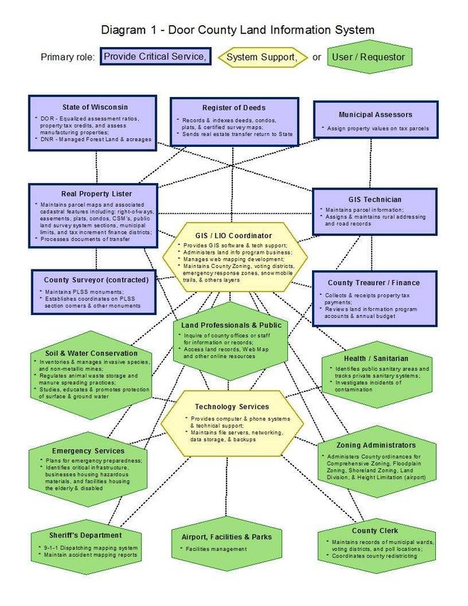
performing their regular business functions; a system diagram on the following page represents those
business interactions. The diagram only represents land information interactions; the diagram makes no
reference to volume or critical need. As one may expect, the Land Information Officer/GIS Coordinator
coordinates with the greatest variation of departments and agencies with regards to land records.
The GIS/LIO Coordinator position and Technology Services Department are critical for supporting the land
information system (shown in light-red box in center of first diagram). Newer technology, software
systems, and networks/internet connectivity are the backbone for a land information system and much of
that planning and support is provided by the LIO and Tech Services.
There are a number of departments that provide a value-added service in managing records (gray box)
that are deemed extremely useful to a land information system, whether or not the user is aware. Door
County’s critical land information that is almost universally used would include tax parcels and road
centerlines, and also the survey and description records that supports their positional accuracy and
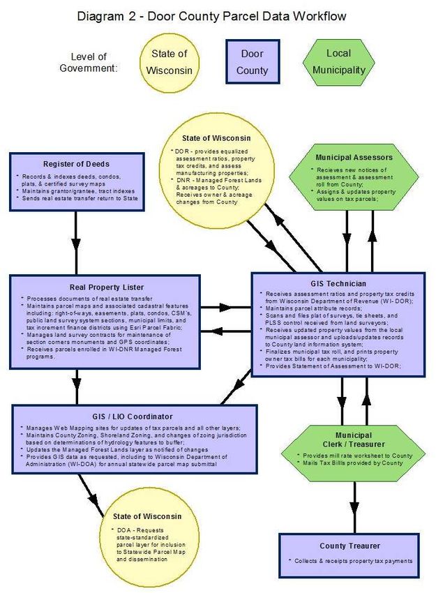
provides the framework reference for most other GIS data layers. The second diagram identifies the
importance of Parcel Data Workflow and provides more detail with regards to responsibilities and
interactions. The various system users and requestors (green boxes) also provide value and enhance the
land information program at the County, but differentiated more due to a specialized focus versus a
universal benefit to almost all users.
A number of departments benefit directly (green box in diagram 1) from the services and tools provided
through an implemented land information system. The professional land use community and general
public would also fall into this category and is located in center box of diagram, as serving the general
public directly needs to continue to be a focus of the land information program. Any specialized group or
department that could benefit from the land information system need to be welcomed and encouraged
to inquire of and request assistance, as appropriate.
23Diagram of County Land Information System
24County Parcel Data Workflow Diagram
25Technology Architecture and Database Design
This section refers to the hardware, software, and systems that the county uses to develop and operate
computer systems and communication networks for the transmission of land information data. Door
County’s land information system involves a number of programs and software to track and process
records. Door County’s land information system runs on the County’s local area network and is supported
by the Technology Services (TS) Department. The TS department manages file storage, software
maintenance, and new system development and implementation. Almost all in-house client workstations
are virtual computers being served up from central servers. In addition, County web sites and remote-
access software such as Citrix provide access to Land Records for mobile County workers through a variety
of portable devices.
Hardware
Aside from computer workstations, other hardware used on a regular basis to support land
information system functions would include compute servers, network storage, rugged tough-
book PC’s, rugged camera (for inspecting sanitary systems), smart phones, scanners, printers,
plotters, copiers, and GPS units. The IBM Power 720 Express server is also the central hub and
houses the index for the County’s document imaging system, which maintains images of plat
of surveys, tie sheets, LOMA’s (FEMA Floodplain Letter of Map Amendment), recorded
documents back to 1966, and tax bills back to 2006 as part of the County’s Land Records
system. Document image files are redundantly stored on two Unix servers and a Windows-
based storage area network (SAN).
Software
Software used regularly includes Esri’s ArcGIS10 Desktop (… and Parcel Fabric structure),
ArcPad on rugged laptops, and old versions of ArcView3 licenses. Soil & Water Conservation
Department (SWCD) makes use of AutoCAD licenses for design drawings and uses Watershed
Modeling Software (WMS) by Aquaveo for modeling water flow. GeoExpress10 by LizardTech
has also been used to convert ortho-imagery from one coordinate system to another and may
be used for processing new LiDAR data.
An IBM Power 720 Express server running the IBM I operating system serves: the land records
database systems for Real Property Listing parcel management and tax bills; Treasurer tax bill
receipting; Planning permit tracking; and Sanitarian permitting, system evaluation, and system
maintenance tracking. All of these systems use a DB2 relational database, which allows for
close integration between the various Land Records applications.
Website Development/Hosting
Door County Web Map was developed by a consultant (Houston Engineering Inc. of
Minnesota) using open-source software MapServer and GeoMoose. The Door County Web
Map allows non-technical users and the general public to access GIS layers and land records
through an intuitive map interface. Pictometry collected imagery can be viewed from their
hosted server for accessing a number of county-wide collection years of oblique and ortho-
imagery. Door County has also utilized ArcGIS Online for creating thematic map applications
that are mobile friendly. Public access to Real Property, Treasurer, Planning, and Sanitarian
Land Records database systems and document images is provided through free and fee-based
web applications. A separate Sanitarian web application enables septic haulers to enter their
monthly holding tank pumping records directly into the Sanitarian system from their office.
These web sites are served from virtual HTTP server instances and Zend PHP server software all
running on the IBM Power 720 platform. In 2017, Register of Deeds converted to Laredo and
Tapestry by Fidlar Systems to provide fee-based online access to Register of Deeds
documents. Door County plans to convert its land records system in this next planning cycle
to retire its IBM server for a web-based solution (probably with GCS or Transcendent
Technologies).
26Sometime in 2019, Door County Technology Services Department may look into having all
Door County websites externally hosted. Effort and coordination by GIS/LIO Coordinator
would need to occur to transfer the Door County Web Map application to an off-site server.
Also, routine data updates and display changes would then occur through a secured logon
internet connection. It is likely that the web applications would be hosted from a number of
different service providers for serving up their specific programs (such as permitting and land
records, on-line mapping, aerial imagery, Register of Deeds documents, department
information and contacts, and allowing on-line credit card payments), but be interlinked for
providing seamless navigation for the user.
Metadata and Data Dictionary Practices
Metadata Creation
Metadata creation and maintenance process: Door County has created metadata on its
more critical, commonly requested GIS layers, including tax parcels, road centerline, and
address points, but does not regularly update the metadata files.
Metadata Software
Metadata software: Esri’s ArcCatalog has been the software used to develop and maintain
geospatial metadata
The software does generate metadata consistent with the FGDC Content Standard for
Digital Geospatial Metadata, and ISO geographic metadata standard 19115.
Metadata fields manually populated: Field description (attributes) are manually populated if
created for a GIS layer.
Metadata Policy
Metadata Policy: Door County has not implemented a policy on minimum metadata
requirements for any of its datasets. However, GIS layers acquired under contract from a
private vendor typicallly include metadata as part of the deliverables.
Municipal Data Integration Process
For the most part, data layers are created and maintained countywide. The City of Sturgeon
Bay and four villages do not fall under the County’s jurisdiction with County Zoning and
various planning support. The County inherited the City parcel mapping and tax database in
about 1994, and therefore the City parcel numbering is somewhat different than the rest of the
County. However, these exceptions have been fairly minor and have not been problematic
integrating into the County’s system.
27Public Access and Website Information
Public Access and Website Information (URLs)
Public Access and Website Information
GIS Webmapping Application(s)
Link - URL GIS Download Link - URL Real Property Lister Link - URL Register of Deeds Link - URL
http://map.co.door.wi.us/map None http://map.co.door.wi.us/RPL/ http://www.co.door.wi.gov/localgov_
departments_details.asp?deptid=48&
locid=137
Single Landing Page/Portal for All Land Records Data
URL
http://map.co.door.wi.us/
Municipal Website Information
Municipal Website Municipal Website URL
City of Sturgeon Bay http://www.sturgeonbaywi.org/
Village of Egg Harbor http://www.villageofeggharbor.org
Village of Ephraim http://www.ephraim-wisconsin.com/
Village of Forestville http://www.villageofforestville.com/
Village of Sister Bay http://www.sisterbaywi.gov/
Town of Baileys Harbor http://www.townofbaileysharbor.com/
Town of Brussels http://www.townofbrussels.com/Home/Index
Town of Clay Banks http://www.townofclaybanks.org/
Town of Egg Harbor http://www.townofeggharbor.org/
Town of Forestville http://www.forestvilletown.com/
Town of Gardner http://www.townofgardner.org
Town of Gibraltar http://www.townofgibraltar.com/
Town of Jacksonport http://www.jacksonport.org
Town of Liberty Grove http://www.libertygrove.org/
Town of Nasewaupee http://www.townofnasewaupee.com
Town of Sevastopol http://www.townofsevastopol.com/
Town of Sturgeon Bay http://www.townofsturgeonbay.us/
Town of Union http://www.townofuniondoor.com/
Town of Washington http://www.washingtonisland-wi.gov/
28You can also read