DRAFT A Review of Weather Station Networks in the Mountain Parks - A Report Prepared for Parks Canada
←
→
Page content transcription
If your browser does not render page correctly, please read the page content below
DRAFT

A Review of Weather Station Networks in the Mountain Parks

               A Report Prepared for Parks Canada

                                By

                       William Thompson
                      Consulting Meteorologist
                         Calgary, Alberta

                                                    November 21, 2005

                                                               Revised Nov 23/05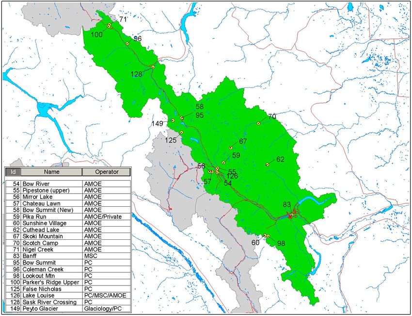
DRAFT

                                  Executive Summary

A review of weather networks in the seven Mountain National Parks was conducted. The
networks were examined on their ability to address needs in the following areas:

a)   Aquatic, vegetation and wildlife studies or management
b)   Forest fire management and avalanche control
c)   Trend monitoring and climate change modeling, assessment and reporting
d)   Climate information for visitors at information centres

Most of the stations were installed to meet Forest Fire Management and Avalanche
Control activities and adequately meet those needs. There are not enough stations
operated by Parks Canada to meet the needs of climate change assessments and its
impacts on vegetation and wildlife. Several other organizations operate weather stations
in the Parks. When the information from these stations is taken into consideration the
network density is near adequate. A core network consisting of 25 existing stations
operated by Parks Canada, three new stations and 26 stations operated by other agencies
is recommended.

Weather information could be delivered to Park Visitors in a more efficient manner. Web
cams are suggested as one means of providing current information. Negotiation with the
Meteorological Service of Canada is required to improve the quality of weather forecasts.

The weather stations are not well maintained and the location and quality of data are in
doubt. It will not be possible to conduct studies without a supply of good quality data.
Priority should be given to improving maintenance and data handling activities.

                                                                                           Revised Nov 23/05
DRAFT

                                                                   Table of Contents

   APPENDIX A............................................................................................................................................... 2
A Review of Weather Station Networks in the Mountain Parks....................................................................... 1
Introduction....................................................................................................................................................... 1
Elements of Program Planning......................................................................................................................... 1
   Network Design............................................................................................................................................ 2
   Field Maintenance......................................................................................................................................... 2
   Standards ...................................................................................................................................................... 2
   Manufacturer’s Support ................................................................................................................................ 3
   Technological expertise................................................................................................................................ 3
   Remote Sensing Capabilities ........................................................................................................................ 3
Needs................................................................................................................................................................ 3
   Aquatic, vegetation and wildlife studies or management ............................................................................. 4
   Forest Fire Management and Avalanche Control..........................................................................................4
     Forest Fire Management ........................................................................................................................... 4
     Avalanche Control.................................................................................................................................... 5
   Trend Monitoring and Climate Change........................................................................................................ 7
   Visitor Information........................................................................................................................................8
Evaluation of the Parks Canada Network ......................................................................................................... 8
Role of National Weather Services ................................................................................................................. 10
Other Networks in and Near the Parks........................................................................................................... 11
   Meteorological Service of Canada (MSC)..................................................................................................11
   Water Survey of Canada (WSC)................................................................................................................. 11
   BC Ministry of Environment...................................................................................................................... 12
   BC Hydro.................................................................................................................................................... 12
   BC Forestry................................................................................................................................................. 13
   BC Ministry of Transportation....................................................................................................................14
   Alberta Environment (AMOE)................................................................................................................... 14
   Alberta Sustainable Resource Development (ASRD)................................................................................ 15
   US Department of Agriculture.................................................................................................................... 16
   Other............................................................................................................................................................16
     Nav Canada............................................................................................................................................. 16
     Research Organizations.......................................................................................................................... 16
     Alberta Transportation............................................................................................................................ 17
Communication Systems................................................................................................................................ 17
   Land line Telephone.................................................................................................................................... 17
   Cell Phone................................................................................................................................................... 17
   Satellite Phone............................................................................................................................................ 17
   Geostationary Operational Environmental Satellite (GOES)..................................................................... 17
   Meteorburst................................................................................................................................................. 18
Assessment......................................................................................................................................................18
                                                                                                                                                                  Revised Nov 23/05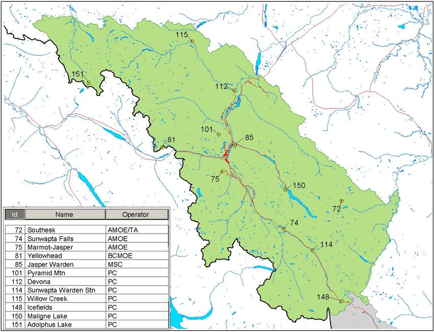
2                                                                                DRAFT
Recommendations .......................................................................................................................................... 21
References ...................................................................................................................................................... 33
Bibliography................................................................................................................................................... 33

             APPENDIX A

                                                                                                                                                                 Revised Nov 23/05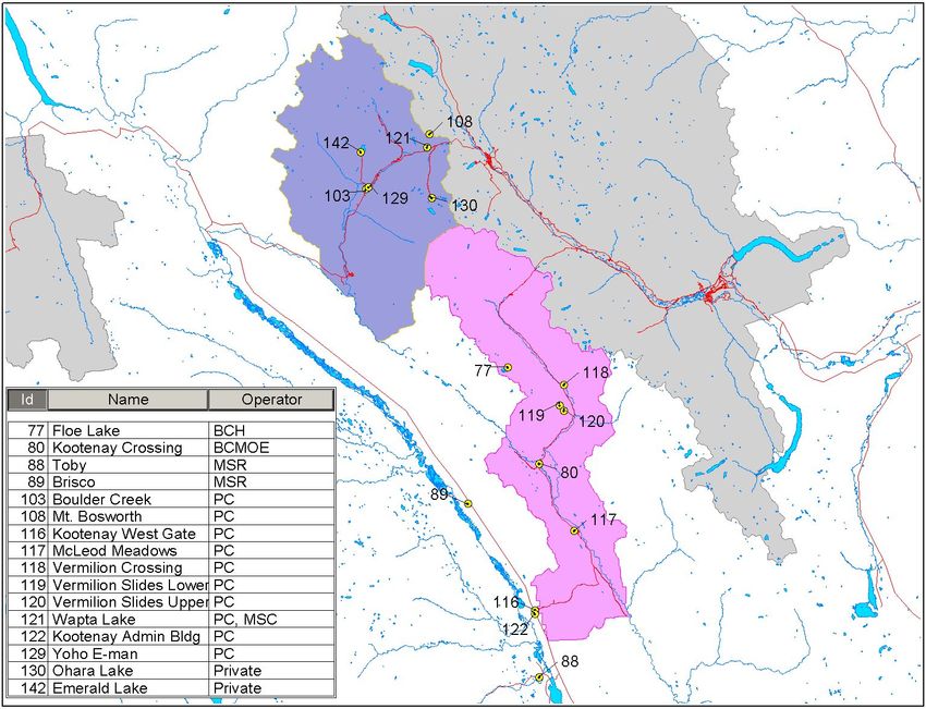
DRAFT

            A Review of Weather Station Networks in the Mountain Parks
                                  Prepared by Bill Thompson
                                   Consulting Meteorologist
                                       Calgary, Alberta

Introduction

Parks Canada has requested that the ability of the current climate and weather monitoring
program in the seven Mountain Parks be assessed to meet the long-term monitoring needs
of the Parks. In the event that the program is found to be inadequate it further requested
that recommendations be made to overcome the deficiencies.

The following undertakes that task. It begins with a compilation of the factors generally
considered in program planning, then determines the needs of the Parks, identifies
stations in the existing networks, and then weighs the ability of those stations to meet the
needs. It briefly examines the cooperative aspects of weather issues by examining the
activities of national weather services. Other organizations are engaged in monitoring
weather in and around the Parks. Their activities are also examined. Finally, the needs are
balanced against the contributions of all organizations engaged in weather monitoring.
The Report concludes with a set of recommendations.

The terms of reference specified that the existing network be evaluated on its ability to
address needs in the following areas:
a) Aquatic, vegetation and wildlife studies or management
b) Forest fire management and avalanche control
c) Trend monitoring and climate change modeling, assessment and reporting
d) Climate information for visitors at information centres

The needs were to be determined in consultation with a number of specialists in each of
the various Parks. Needs relating to highway maintenance, except for avalanche control,
and air quality management were to be excluded

Parks Canada provided the location of weather stations and the instrumentation at each
station. No provision was made to visit any of the stations though, as will be noted, the
Consultant did inspect a few sites in connection with other activities.

Elements of Program Planning

A meteorological program consists of several components. Network design is an
important one but the ability to support the program is equally important. Supporting
components include: maintenance, standards, manufacturer’s support, and technological
expertise. A program should also undergo periodic review to determine if new

                                                                                            Revised Nov 23/05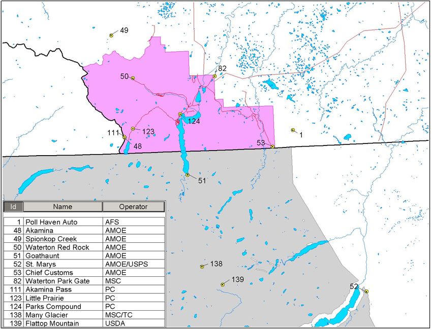
2                                               DRAFT
technologies such as those offered by remote sensing might replace conventional
monitoring activities.

Network Design

Many approaches to network design exist. They range from the purely theoretical to the
practical. At one extreme stations are distributed in a random manner using statistical
theory. At the other stations are only at locations to meet a specific need such as, for
example, avalanche control.

The practical approach is favoured here. However, it is necessary to understand the
meaning of need. Forthcoming sections will outline needs identified by Parks staff and
this review will focus on meeting those needs. However, there are other underlying needs
that are not so obvious but yet necessary for long term planning.

The network should strive to improve our knowledge of local climates. The climate of the
Parks is not well understood. Janz and Storr (1977) conducted the only examination of
the climate in the Mountain Parks. It was confined to the four contiguous Parks; Banff,
Jasper, Kootenay and Yoho. No climatological studies have been conducted for Waterton,
Glacier or Mt Revelstoke National Parks.

There is also a need to provide feedback to atmospheric models. Atmospheric models
describe the ongoing weather events and are the basis for weather prediction. The
resolution of these models is increasing. The current generation of models has a
resolution of 15 kilometres. This means that they are capable of identifying weather
events as small as 15 km in breadth. This is approaching the scale where the influence of
local mountain ranges on precipitation can be quantified. To achieve this capability
information must be fed back from a network of similar scale. In other words the network
should contain one station per 225 square kilometres on average.

Field Maintenance

Factors to be considered in the operation of a network are: installation, maintenance,
power supply and communications. These factors consume a large portion of the budget
when weather stations are installed at remote locations.

Standards

A frequently unrecognized aspect of operating a monitoring program is the compilation
and management of data. Analysts and others conducting studies expect the data to be in
a recognizable format and free of errors. Reformatting and error removal is time
consuming and costly. Adhering to standard procedures all the way from the installation
of the sensors to the delivery of the database will reduce the amount of erroneous data.
Standards are required for:

•   Sensor specifications
                                                                                           Revised Nov 23/05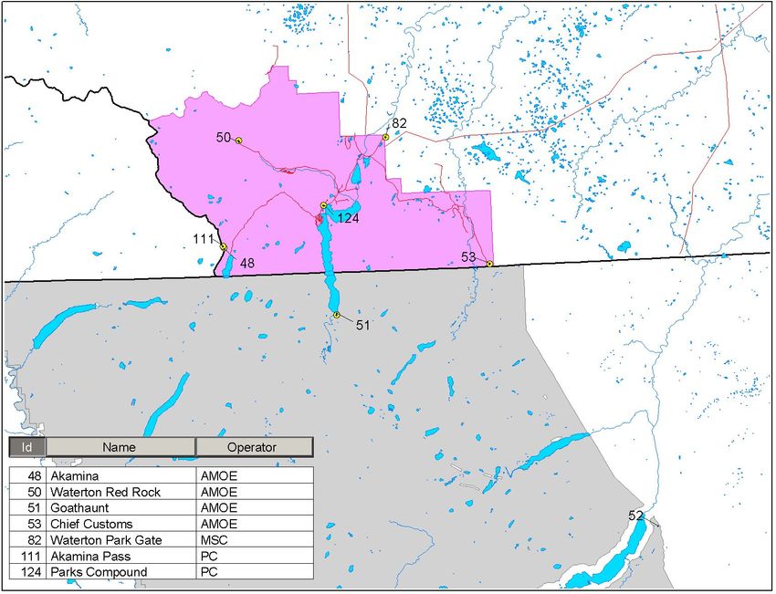
3                                              DRAFT
•   The siting of the weather station
•   The mounting of the sensors
•   The monitoring of the sensors
•   The coding and delivery of data
•   The quality control procedures
•   The coding and formatting of stored data

Manufacturer’s Support

It is desirable from maintenance and data management perspectives to minimize the
variety of equipment in use. The ability of the manufacturers to support to supply and
support their products is an important factor in equipment selection.

Technological expertise

The installation, operation and maintenance of weather stations and associated equipment
including data loggers and modems are detailed and complex. An inventory of sensors at
each weather station must be maintained and updated, sensors calibrated, field equipment
routinely checked for accuracy, and repairs made as necessary. These activities require
special skills and should be performed by an individual possessing a good knowledge of
instrumentation and electronics.

Data collection and management activities also tend to be complex. Software is required
to reformat and display data. Data must be checked for accuracy and erroneous
information either corrected or removed. The data must be submitted to an archive, and
the archive must be maintained. Information contained in the archive should be readily
available to a variety of users including those charged with preparing climatological
statistics. Again it is desirable that these tasks be assigned to an individual with a good
knowledge of data processing and computer technology.

Remote Sensing Capabilities

Remote sensing techniques are continually being introduced to monitor weather
conditions. In some areas they reduce the reliance on weather stations. Weather radar,
satellite imagery and lightning detection fall into this category. Unfortunately, the
operation of all three is limited in mountainous terrain. The need for surface based
observations will continue to exist in the Mountain Parks.

Needs

One or more staff members were interviewed in each of the seven Mountain Parks to
determine the present and anticipated needs for weather information. Among these were
attendants at three Information Centres. Staff members in the Calgary Regional Office
and in Headquarters in Ottawa were also interviewed. Most of the interviews were
conducted by telephone but a few were conducted in person. A summary of the comments
follows.
                                                                                         Revised Nov 23/05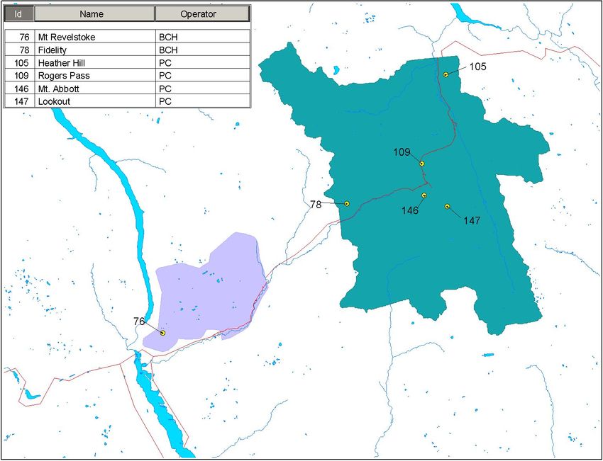
4                                               DRAFT

Aquatic, vegetation and wildlife studies or management

Most of the comments related to studies as opposed to management. The impact of
climate change was expressed as a concern. Vegetation boundaries are expected to shift
upward due to warming. Fish and waterfowl populations are expected to be impacted as
wetland areas respond to changes in runoff patterns from glaciers.

Studies tend to be of a correlation type in which changes are related to weather elements.
The elements most often examined are air temperature, precipitation including snow
depth and humidity. The behavioral changes tend to take place over a few days or weeks
or longer so that a need for a high sampling rate for weather information is not required.
Daily measurements would meet most requirements.

Typical studies undertaken included the migration habits of large mammals in Banff
National Park and the foraging activities of woodland caribou in Mt. Revelstoke, Glacier
and Jasper National Parks. The independent variable in the migration study was
snowmelt and in the foraging study was snow depth.

Chemicals are used in highway clearing operations. They are released into streams during
melt periods. The impact of the chemicals was not identified as a concern but was
nevertheless taken into account in network design.

Forest Fire Management and Avalanche Control

Forest fire management and avalanche control have the greatest need for weather
information. Both are seasonal activities. Forest fire management requires weather
information during the summer season; avalanche warning/control during the winter
season. Both need information in real time i.e. within a few minutes or hours of
observation.

Forest Fire Management

Day to day activities conducted for forest fire management in the Parks are generally
done in accordance with the Fire Weather Index (FWI) System, a procedure for
monitoring fire danger conditions and a major component of the Canadian Forest Fire
Danger Rating System. Most Provinces and the territories adhere to this System.

The FWI uses daily weather observations to estimate the moisture content of three
different fuel classes. These in turn are used to generate a set of relative indicators of
potential rate of fire spread, fire intensity, and fuel consumption.

The Fire Weather Index is started at the beginning of the season and updated daily as the
season progresses. Each Unit collects noon time weather observations from the local
weather stations. They are entered into a model that calculates the FWI at each station.
The updated values are held in local storage where they become accessible by the
                                                                                             Revised Nov 23/05
5                                                DRAFT
Regional and National Offices. They are distributed from these Offices to the Canadian
Wildland Fire Information System where they are integrated into the national daily fire
weather map. This map is used by managers at the local, regional and national levels to
shift resources to the areas of greatest fire threat. The values also enter a database where
they are available for climatological purposes.

The FWI System requires observed temperature, relative humidity, and wind speed at
noon local standard time, as well as 24-hour precipitation. The System requires an
unbroken record of daily weather. If a station fails to report or reports missing data, the
missing values must be estimated.

While the Parks participate in the national data management system, the strategy for
forest fire suppression in the Parks differs from that in most Provinces and Territories.
The Provinces and Territories consider the forests a resource and take steps to combat a
fire. The Parks view fire as a natural event. Thus the Parks will not necessarily take
action to combat a fire unless it threatens a community, a transportation corridor or
adjacent forest outside the Park.

The BC Ministry of Forests and Range (Forestry section) and the Alberta Forestry
Service operate weather stations adjacent to the Parks. Agreements exist to exchange data
at the local level. Nearly all of the weather stations used by the BC and Alberta BC Forest
Services are manufactured by Forest Technology Systems (FTS). The stations were
chosen because of their ease of programming and their portability.

Overall, the density of weather stations was felt to be adequate but a desire existed for
better coverage at fringes of the Parks where a fire might spread onto Provincial lands.
The Beaver Creek watershed in Glacier National Park is subject to lightning strikes and
might also merit better coverage. Staff members outside the Units expressed some
dissatisfaction with the communications system. The radios occasionally fail and prevent
access to the data. When the failure occurs at a repeater station the data from more than
one station is unavailable. The protocol for radio communication varies from Unit to Unit
so that a variety of download procedures are required. Incompatibility with some versions
of MS Windows was cited as another problem. A standardized system is preferred.

Only one weather station has existed in Mt Revelstoke National Park and its future seems
to be in doubt. It was located in the Compound near Mile 1 and has been dismantled for
the season. The Compound may close over winter so that the station cannot be returned to
its usual location next year.

Avalanche Control

Each of the Units within the seven Parks conducts an avalanche program. The monitoring
program in the Glacier Unit is more intense than in the other Units because of the
importance of keeping the Trans Canada Highway clear.

                                                                                              Revised Nov 23/05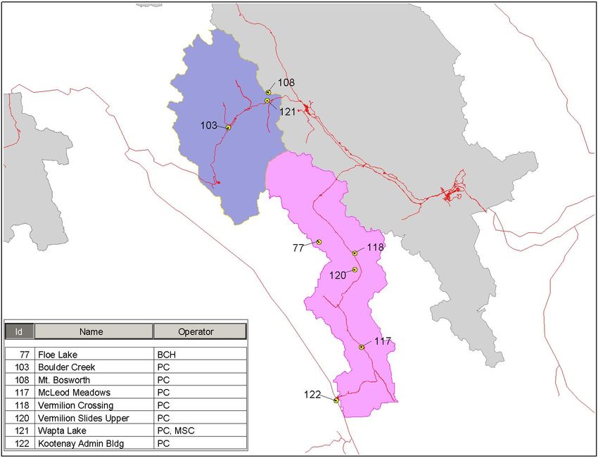
6                                                DRAFT
All Units provide daily Avalanche Bulletins that advise hikers and others of the risk of
avalanches over the forthcoming two days. The Bulletins are forwarded to the Canadian
Avalanche Association in Revelstoke where they are posted on a web site for public view.
The Bulletin from Glacier National Park is posted in the morning whereas the Bulletins
from all other Units are posted in the afternoon. The Bulletins are also available on the
web sites of the respective Parks

The Bulletins contain snow profile, forecast and observed weather information. In the
LLYK Unit snow profiles are scheduled to be taken twice per week and an additional 2 to
3 more may be taken during the week depending on need. The atmospheric parameters of
interest are temperature, humidity, wind and precipitation. The snow depth, time of year,
and recent history of avalanches are also factors. Avalanche risk is determined partly on
theory and partly on the experience of the forecaster.

In the Glacier Unit, nine weather stations will exist during the 2005-2006 snow season.
The Illecillewaet and Perly Lake stations, which have been used for glacier monitoring in
the past, will be shut down. In 2005 a new station, Mt. Abbott, was installed. An
avalanche warning sensor exists at Cougar 6 but the location provides no weather
information. The Heather Hill station is adjacent to the Trans Canada Highway and is
equipped with conductivity and road temperature sensors to monitor highway conditions
as well as to serve as an avalanche control station.

All stations are equipped with Campbell Scientific, Inc data loggers, VHF radios, and
modems. The stations are polled at ten minute intervals. This is a high rate of data
recovery and is undertaken to overcome a deficiency in the system which does not allow
the remote stations to initiate contact with the base station. Some of the remote stations
are equipped with avalanche sensors. By polling at ten minute intervals an avalanche is
detected within not more than ten minutes of its occurrence.

Data are downloaded and stored on a local server. Records are held in-house and extend
back to 1988. Manual checks are undertaken to remove errors. Service manuals exist for
all sensors. Wiring diagrams have been prepared to standardize station configurations.
Manuals containing programming and processing instructions for all sensors exist.

The Campbell Scientific, Inc. data loggers and radios are not current generation.
Campbell Scientific, Inc. indicated that it would continue to repair the data loggers as
long as parts are available. At present a good supply of parts exists. The situation is not
the same with the radios. They are obsolete and the current generation radios are not fully
compatible with the older data loggers. Various options to overcome the incompatibility
are being examined.

The stored data have not been used for analysis purposes except for the calculation of a
few statistics on snow depth.

Sites at Rogers Pass and Mt. Fidelity have been inspected by the Meteorological Service
of Canada and found to meet its standards for climatological stations. Maximum and
                                                                                           Revised Nov 23/05
7 DRAFT
minimum temperatures and precipitation are manually recorded each day and forwarded
to the Meteorological Service of Canada. Apart from these two locations no data from
any of the locations reaches the Meteorological Service of Canada for forecast or archival
purposes. Security was cited as the reason for keeping the data in-house though overload
of telephone lines, capacity of the server and interference with alarm systems were also
identified as concerns. This situation may change as data from all stations will be
forwarded to the Canadian Avalanche Centre where they become available to subscribers.
The Meteorological Service of Canada is a subscriber.
Most of the stations are at or near the tree line and therefore subject to lightning strikes in
summer. All are taken out of service except Mt. Fidelity during the summer season to
prevent damage. The equipment at Mt. Fidelity is moved to a lower location and the
station re-activated to assist in the fire weather program.
There are no weather stations used for avalanche purposes in Mt. Revelstoke National
Park. Only one avalanche station operates in Waterton National Park.
Avalanche conditions develop differently in the Selkirks than they do in the Rockies.
Avalanche conditions often set up within hours in the Selkirks whereas the set up period
is of the order of a day in the Rockies. Thus hourly weather observations are required in
the Selkirks whereas daily observations are adequate in the Rockies.
It was felt that a few more high-level weather stations could be used in the LLYK Unit
otherwise the existing network was adequate.
Trend Monitoring and Climate Change
There were few comments on trend monitoring and climate change. Most related to the
impacts on wildlife and vegetation addressed above. Other impacts must be speculated
upon.
Scott and Suffling (2001) indicated that General Circulation Models point to temperature
rises in the 5 to 7 Deg C range over the next 100 years. The models are not so clear on
changes in precipitation amounts. However, with rising temperatures snowlines can be
expected to rise, runoff can be expected to begin earlier, and the rain/snow balance at
most locations will shift in favour of more rain. Glaciers will also be affected. Some may
decrease; others may expand. The end result will be significant changes in the
hydrological cycle.
The changes will produce secondary impacts. Possible impacts might include changes in
soil stability. Species and ecosystems may be forced to migrate uphill forcing those
whose climatic ranges are already limited to mountain tops to become extinct. Changes in
the water supply to downstream users may result in changes in societal attitudes toward
the operation of the Parks.
Revised Nov 23/058 DRAFT
Climate change studies require meteorological data over a long time period. Existing
networks operated by the Parks provide inadequate snow pack information to understand
the mechanisms projected to take place in the hydrological cycle. It therefore seems
prudent to monitor elements affecting the water balance so that informed decisions can be
made as the impacts of climate change are felt.
Visitor Information
There are numerous visitors to the Parks each year. Sightseeing, hiking, camping and
skiing are among many of the activities that draw visitors to the Parks. Weather is one of
the most sought after pieces of information.
Weather information is provided by a number of means. These include Parks Canada
operated web-sites, personal and telephone contact at Visitor Information Centres, and
recorded telephone messages. The web sites provide direct links to a Meteorological
Service of Canada website where weather forecasts and some current weather
information exists. The Meteorological Service of Canada information is distributed to
Visitor Information Centres where it is used by local staff to respond to visitor queries. It
is also posted at some Centres for public view.
There are other sources of weather information. Weather information is contained in
avalanche bulletins. Businesses, primarily ski resorts, operate their own weather stations
and web cams. Their information is distributed to the media and posted on their own
websites.
Attendants in Information Centres that were visited indicated that a lot of requests are
received for current weather conditions. Many are for conditions at tourist sites but there
are also many for up to date weather information on the highways especially when
weather conditions are changing. Most callers seek sky and visibility information. The
attendants indicated that they occasionally call other centres for current information.
Evaluation of the Parks Canada Network
In addition to the interviews with Parks staff, the Consultant undertook a number of steps
to evaluate the performance of the existing Parks Canada network. Web sites for all of the
Parks were examined. Trips were made by road through five of the Parks (Banff,
Kootenay, Yoho, Glacier and Mt Revelstoke). The following weather stations were
inspected: Kootenay West Entrance Administration Building, McLeod Meadows,
Vermilion Crossing, Banff, Lake Louise, Wapta Lake, Boulder Creek, Yoho E-MAN,
Golden Airport, and Rogers Pass. Available documentation on the network was also
examined.
Overall, the hardware including the sensors, data loggers, towers and power supply are of
good quality. Stations installed for a specific operation such as avalanche control and fire
weather applications are for the most part well placed.
Revised Nov 23/059 DRAFT
However, there are a number of shortcomings. Lack of maintenance exists in some of the
Units. Cleaning and calibration of sensors is not regularly scheduled and some of the sites
need maintenance. Both contribute to measurement errors. Calibration records for
sensors are not always complete nor are records of sensor changes.
Station description sheets are not complete and are not regularly updated. Differences in
co-ordinates and elevation exist for the same station in records held by the Units and by
the Meteorological Service of Canada. This makes it difficult to determine whether one
or more stations operate at the same location. Some stations operate under different
names. For example, the hourly reporting station operated at Banff is called Banff by the
Meteorological Service of Canada and Banff Indian Grounds by Parks Canada.
Partnership agreements exist which are not documented. For example, there appears to be
three partners in the station at Lake Louise.
The location of data from some stations seems to be in doubt. It is also not clear what
steps were taken to prevent erroneous data from entering the databases.
All of the foregoing create major problems for analysts. Considerable effort will be
expended locating data and removing errors.
Some of the stations are not well sited. For example, the temperature sensors at Kootenay
West Gate Administration and Boulder Creek are located on walls or rooftops. Radiation
from the walls or rooftops in such close proximity can easily result in an error of one
degree in temperature, an error that would render the equipment unsuitable for trend
monitoring purposes. At other locations the wind sensors are located below the tops of
nearby trees and are subject to turbulent eddies.
There are a number of weather stations operated by other agencies within the Parks or
near Park boundaries that measure parameters useful for Park applications. Some are very
close to stations operated by Parks Canada creating the opportunity to share costs. For
example, there are two stations at Bow Summit, two at Akamina and up to four stations
on Mt. Fidelity. An example of cost sharing exists at Bow Summit where two stations
exist and share the same precipitation gauge.
The real time weather information distributed to Park visitors is not always complete nor
is it the most representative. The individual Park web sites provide weather information
through a link to Environment Canada. For all of the Parks, except Glacier and Mt.
Revelstoke, the link displays a forecast and current weather information. A link is not
provided for Glacier and Mt. Revelstoke and therefore no weather information is
available other than that contained in the seasonal Avalanche Bulletins. The current
weather information presented on the links for the other Parks is not always the most
representative nor does it provide the information desired. For example, the Wapta Lake
station in Yoho National Park provides the current weather information for Kootenay
National Park. No information is provided on cloud cover, visibility and precipitation
which play a fairly important role in planning the daily activities of many visitors. The
information provided at some Visitor Centres is not necessarily representative. For
Revised Nov 23/0510 DRAFT
example, weather information posted at the Radium Hot Springs Visitor Centre was
found to display current information from the Cranbrook Airport.
Role of National Weather Services
The atmosphere over a given land area is not a closed system. Air is continually entering
the upstream side and departing through the downstream side. The borders are porous.
The air is a resource and must be managed collectively.
Using the Mountain Parks as an illustration, managers need to be concerned about the
quality of air entering from upstream. Those downstream have not only to be concerned
about the quality of the air leaving the Parks but also the quantity and quality of water in
streams and rivers resulting from condensation of the water vapour lost in transit over the
Parks. Thus a need exists to cooperate with jurisdictions both upstream and downstream.
The need for cooperation extends beyond provincial borders. Rivers flowing from some
of the Parks reach the United States. Conversely, pollutants emitted in southeast Asia
reach western Canada.
Nearly all countries have a weather service charged with a variety of activities related to
the management of the atmosphere including the responsibility for monitoring and
forecasting weather conditions. Most belong to the World Meteorological Organization
(WMO). The WMO is a UN body. It sets standards and procedures for atmospheric
monitoring. It also provides a forum for addressing atmospheric issues.
Canada’s national weather service is the Meteorological Service of Canada. It does not
have complete responsibility for all atmospheric issues. For example, stream flow
prediction and air pollution control are provincial responsibilities. However, it does have
responsibility for weather prediction. It develops and runs global atmospheric models for
this purpose. The models require weather observations as input. The Meteorological
Service of Canada operates its own network of weather stations but must rely on other
jurisdictions to supplement that network.
The model output is distributed to regional centres and to private companies where it is
interpreted and tailored to meet specific applications. Regional Centres in Edmonton and
Vancouver prepare forecasts for Alberta and BC, respectively.
Climatological data captured from local weather stations is fed back into the forecast
system to improve performance. This happens in two ways. Firstly, the information
allows the models to provide greater local detail. As an example, the information will
indicate to the model that under certain circulation patterns the eastern slopes of the
Rockies will be overcast and wet while interior valleys are cloud free. Secondly, forecasts
are continually being verified. The more information that is fed back, the greater the
opportunity to identify areas of poor performance. The atmospheric models are gradually
increasing in accuracy. Their ability to identify local variations requires local input to
keep pace.
Revised Nov 23/0511 DRAFT
Weather forecasts are important to the Parks and to agencies operating within the Parks.
Precipitation forecasts, particularly those of snow, are used extensively by those clearing
highways, preparing avalanche warnings and controlling avalanches, operating ski
resorts, and clearing railroad tracks. Less apparent but equally important are aviation
weather forecasts. Helicopter pilots flying on Parks contracts rely on them for flight
planning. Low ceilings, poor visibility and extreme turbulence are critical factors to
flight.
In summary, weather forecasting is a cooperative effort extending from the local to
international level. The Parks must contribute to the effort to receive benefit in return.
Other Networks in and Near the Parks
Weather stations are operated by several agencies in and near the Parks. The locations of
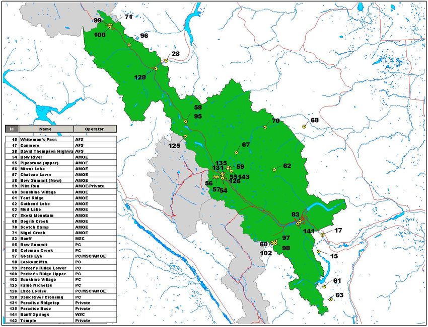
the stations operated by the various agencies are shown in Figures A1a, A1b and A1c of
Appendix A. The equipment and operating details are shown in Table A1. Only stations
lying within about 10 km of Park Boundaries are shown.
A few other stations exist that are operated by private companies and individuals. In most
instances they record only maximum and minimum temperature and precipitation. They
are not included.
Meteorological Service of Canada (MSC)
The Meteorological Service of Canada operates three stations within the Parks. These are
Banff (Banff Indian Grounds), Jasper (Jasper Warden) and Waterton Park Gate (Crooked
Creek). A fourth, Yoho (Wapta Lake), is jointly operated with Parks Canada. All are
hourly reporting stations. The hourly data are fed into the national data collection system
and are used for forecast purposes.
Data from a number of stations operated by other agencies also reach the Meteorological
Service of Canada but they do not enter the forecast stream. These data are checked for
quality and placed in the Meteorological Service of Canada archive where they become
available for public use. The stations in and near the Parks having data that enter the
archive are those displaying a Meteorological Service of Canada identification number in
Table 1. Only data from 12 of the 33 stations solely operated by Parks Canada enter the
MSC archive. Of the twelve most are located in the Parks in Alberta.
Not all precipitation data exist in the MSC archive. Data from snow pillows and snow
courses are held by the Provinces owing to their mandate for the management of water
resources.
Water Survey of Canada (WSC)
Water Survey of Canada operates a network of hydrometric stations across Canada. The
primary purpose of these stations is to measure flow in rivers and water level in lakes.
Revised Nov 23/0512 DRAFT
Four stations exist in the Mountain Parks. The locations are the Athabasca River near
Jasper, the Miette River near Jasper, the Bow River at Banff and the Kootenay River at
Kootenay Crossing. A fifth exists close to the boundary of Glacier National Park on the
Illecillewaet River at Greeley. Most of these stations are equipped with a data logger and
either a telephone modem or GOES transmitter.
The data loggers have the capacity to monitor additional sensors such as those used to
measure temperature, wind speed and direction, and humidity. For example, the
Illecillewait and Bow River stations also measure air temperature. None of the other
stations are equipped with sensors to measure atmospheric elements.
Stream flow stations are operated on a partnership basis. The Federal Government has the
greatest interest in monitoring stream flow but other agencies also have an interest. The
WSC acts as the lead agency and negotiates costs with partners. The Alberta Department
of Environment, BC Ministry of Environment and BC Hydro are listed on its web site as
partners. Parks Canada is not identified as a partner. Data from the stations can be found
at http://scitech.pyr.ec.gc.ca/waterweb/selectProvince.asp.
BC Ministry of Environment
Two sections of the BC Ministry of Environment have responsibilities for the collection
and management of weather data. One is the River Forecast Centre (RFC). It collects and
interprets snow, meteorological and stream flow data to provide warnings and forecasts
of stream and lake runoff conditions around the province. Most of the meteorological and
stream flow data are collected by other agencies, but the RFC is the lead agency in the
province for the collection, quality control, analysis and archival of snow data. It does not
operate any stations directly in the Mountain Parks but it does receive data from stations
operated by BC Hydro. It publishes the Snow Survey Bulletin (http://
wlapwww.gov.bc.ca/rfc/river_forecast/bulletin_summer.htm). It also maintains an archive
of snow pillow and snow course data.
The second section is the Air Protection Division. In conjunction with local air sheds it
operates air quality monitoring stations. None of these stations are located in the Parks
but stations do exist in the communities of Golden and Revelstoke.
BC Hydro
BC Hydro operates four stations within or very near the Parks. They are located at Floe
Lake in Kootenay National Park, on Mt. Revelstoke near the boundary of Mt. Revelstoke
National Park, and on Mt. Fidelity and Rogers Pass in Glacier National Park. Information
from the stations is used to control the operation of reservoirs and estimate power
generation.
All stations measure temperature and precipitation on an hourly basis. The stations at
Floe Lake and on Mt. Revelstoke are equipped with snow pillows that are also monitored
Revised Nov 23/0513 DRAFT
on an hourly basis. Snow course surveys are conducted adjacent to the two snow pillows.
They are conducted manually at the beginning of each of the winter months.
BC Hydro stations are equipped with GOES transmitters. The data are downloaded and
posted at (http://www.bchydro.com/info/res_hydromet/res_hydromet9820.html) where
they are held for 72 hours. After 72 hours the data are removed from the web site and
submitted to an archive. Some manual and automated checking for errors is conducted
prior to entry. The stored data are available on request. An agreement with the
Meteorological Service of Canada does not exist and the data do not enter the
Meteorological Service of Canada archive.
The precipitation gauges are a custom made standpipe/pressure transducer type.
BC Forestry
The Ministry of Forests Protection Program operates 214 hourly reporting weather
stations throughout BC. None are located within the Mountain Parks but a number are
fairly close to Park boundaries. The weather observations are used to support fire weather
forecasting and to update Fire Weather Indices. The indices are forwarded for entry into
to the Canadian Wildland Fire Information System.
FTS stations are used exclusively though not all are current generation. The Ministry is in
the fourth year of a seven year replacement program. Data are recovered in real time by a
variety of means. Most stations telemeter data via UHF radio but 67 stations are on
meteorburst, 40 on landlines, 4 use Globalstar and one transmits via cell.
The data are transmitted to Protection headquarters, every hour from April through
October and less frequently during the winter months. Data from the stations are
synthesized and maps of temperature, humidity, precipitation and wind speed are
produced daily and displayed on a web site. Parks Canada has access to data from
individual stations through an interagency cooperative agreement. Past data are stored in
Ministry facilities. The data base contains data as far back as 1970. All data from the
stations are submitted to the archive by electronic means. Checks for errors are basic and
consist of range checks and manual flagging of suspicious data. The data are made
available to the Meteorological Service of Canada but are not archived by the
Meteorological Service of Canada. Historical data would be made available on request.
Maintenance and some calibration are done in house. The balance of the calibration is
performed by the Manufacturer. The field units are modular and repairs are often made in
the field by swapping out parts. No field maintenance is performed over the winter, so
sites that fail usually remain inoperative until the pre-season service has been completed.
Sites are selected to conform as nearly as possible to WMO siting criteria but difficulty is
experienced in finding sites that meet the criteria for wind.
Revised Nov 23/0514 DRAFT
BC Ministry of Transportation
A Road Weather Information System is in operation on BC’s Highways. This system
collects road surface information and measures temperature, relative humidity,
precipitation and wind speed and direction on towers adjacent to the highways. The
information is used to support highway clearing operations. The System is part of a
broader Road Weather Information Systems initiative. The initiative is a joint provincial,
territorial, Transport Canada and Environment Canada program. As a condition of
funding, provinces and territories are required to enter into a data-sharing agreement with
Environment Canada.
ICBC in cooperation with Environment Canada and the BC Ministry of Transportation
posts the data at http://www.weatheroffice.pyr.ec.gc.ca/icbctravelalert/dtables_e.html.
No roadside stations exist in the Mountain Parks but there are stations near Park
boundaries. Stations are located north of Invermere on Highway 95, east of Golden on
Highway 1 at Top of Ten Mile, and east of Revelstoke on Highway 1 near Albert Canyon.
A fourth station was observed on Highway 1 just east of the Glacier National Park
boundary. It does not appear on the web site and its status is unknown.
Alberta Environment (AMOE)
Weather monitoring is conducted by the Water Management Division of the Alberta
Ministry of Environment for various uses including the preparation of river and water
advisories and warnings, water data, and water supply reports.
Several stations exist on the foothills and in the mountains including locations within
Banff, Jasper, and Waterton National Parks. There are also two stations in the US Glacier
National Park. The elements most commonly measured are temperature, total
precipitation, and stream flow but some stations are equipped to measure humidity and
wind speed and direction. Fischer-Porter precipitation gauges are most commonly to
measure total precipitation but a few Pluvio gauges are also used. All are fitted with
shields.
Snow pillows exist at a number of sites and snow courses are operated at a few others.
Nearly all of the stations are equipped with GOES transmitters but a few transmit data via
telephone landline. The majority of the stations equipped with GOES transmitters
transmit data at one hour intervals. Precipitation is usually measured at fifteen minute
intervals but held on site until the next available transmission. All telemetered data are
posted on a web site and displayed for 72 hours. After 72 hours the oldest data are
dropped off. The location of the stations and a record of recent and current data are
available at: http://www3.gov.ab.ca/env/water/basins/basinform.cfm.
Data older than 72 hours enter a data base operated by Alberta Environment. The data are
not subjected to rigorous quality control. They are available to outside users on request.
Alberta Environment has a number of technical staff responsible for selecting sites,
taking field readings, and making repairs in the field. They also maintain and update
Revised Nov 23/0515 DRAFT
station description sheets and keep an inventory of equipment. Maintenance is conducted
in-house but sensors are sent out to manufacturers or calibration shops for major repairs
and calibration.
Not all stations conform to WMO siting standards. For example, stations located in heavy
snowfall areas are mounted on platforms to prevent temperature sensors from becoming
snow covered.
About 140 air quality stations are operated in Alberta. None collect weather information
in the Parks or near Park boundaries but some passive monitors are located within the
Parks.
Alberta Sustainable Resource Development (ASRD)
The Forest Protection Division of ASRD collects weather observations to support its fire
suppression operations. It also operates a network of Storage precipitation gauges to
measure seasonal precipitation.
The weather observation network extends over the forested areas of the Province
including areas adjoining Banff, Jasper and Waterton National Parks. Most of the weather
observations are taken at Lookout Towers. The Towers are staffed during the summer
months. The observations are made twice daily, at 6AM and 1PM, by the Tower operator.
They are transmitted by radio to the Forecast Centre where weather forecasts are
prepared to support fire suppression operations. The weather is also observed at about 48
other locations using FTS automatic weather stations. Slightly over half of these stations
transmit data via cell phone and the remainder via the Globalstar communications
system. Observations are made hourly but downloaded three times per day except in fire
situations to reduce communications costs.
Elements measured are temperature, dew point, precipitation, and wind speed and
direction. The stations operate from April to November though a few operate year round.
Data from the stations are posted at http://www3.gov.ab.ca/srd/wildfires/fpd/w_wfo.cfm.
The data are forwarded to the Meteorological Service of Canada where they are entered
into the national archive and are available online.
A network of Sacramento Storage gauges was installed by the Eastern Rockies Forest
Conservation Board between about 1950 and 1970. This Organization was phased out
about 1974 and the responsibility for operating the Storage Gauge network was
transferred to the Forest Protection Division. The gauges in the network are simple
standpipes which are visited and the contents measured twice per year; once in the spring
and once in the fall. They are then emptied and recharged. Thus only measure seasonal
precipitation is measured. They are not equipped with shields. Some of the gauges are
located within Banff and Jasper National Parks.
Revised Nov 23/0516 DRAFT
The gauges are becoming obsolete as more and more real time reporting precipitation
gauges are installed. However, they provide useful information on moisture reserves. The
data are held by the Forest Protection Division and can be obtained without charge.
US Department of Agriculture
Two real time reporting stations exist in the US Glacier National Park within a few
kilometres of Waterton National Park. Both are part of the SNOTEL (SNOwpack
TELemetry) network. The data are used for forecasting and management of water
supplies. The stations are Flattop Mountain and Many Glacier. The Natural Resources
Conservation Service (NRCS) of the US Department of Agriculture installs, operates, and
maintains the network.
SNOTEL uses meteor burst communications technology to collect from the stations. The
stations are battery powered with solar cell recharge.
Data are posted at http://www.wcc.nrcs.usda.gov/snotel/Montana/montana.html. They are
also available on the Alberta Environment web site.
Other
Nav Canada
NAV CANADA is a private corporation that owns and operates Canada's civil air
navigation service (ANS). It provides air traffic control, flight information, weather
briefings, and other services to the aviation community. Hourly reporting weather stations
are operated on the Golden and Revelstoke Airports. These are the only weather stations
providing cloud cover and visibility information between Springbank, Alberta and the
Okanagan Valley. A weather station is also operated at the Cranbrook Airport to aid
flights over southern BC.
Research Organizations
Research projects are conducted in the Parks. Weather stations are set up to obtain
weather information for some of these projects. One of the longest standing projects is a
program operated on Peyto Glacier under Canada's Glacier-Climate Observing System.
Weather stations have been operated for various periods. The data are logged on site and
the data recovered at periodic intervals. Historical data are held by various researchers.
The records are often incomplete owing to failure of the loggers under the harsh
environmental conditions. The stations are one of the few sources of solar and terrestrial
radiation measurements in the Parks.
Radiation measurements are also made in conjunction with avalanche research being
conducted in Glacier National Park
Revised Nov 23/0517 DRAFT
Among other known projects is a seven weather station network in Waterton National
Park. The stations form a transect with the objective of measuring local climate
variations.
Weather data have also been collected in a Project near Sunwapta aimed at studying
permafrost.
Alberta Transportation
A Road Weather Information System is being installed on Alberta Highways under the
same program used in BC. The installation has been slower to get under way. A contract
was issued in the summer of 2005 to Telvent, a European company. About 75 weather
stations will be installed and some of these will likely be near Park boundaries. Some of
the hardware is in place but the system is not yet operating. It is not known how the data
will be made available.
Communication Systems
Radio is the method most commonly used to telemeter data from the weather stations
located in the Parks. It serves the purpose fairly well but occasional failures were noted.
These resulted in the inability to recover data in real time. Also the present configuration
of data recovery was found unwieldy.
Other communications system exist which can be used to telemeter data. They are
provided here with brief comments. The comments do not provide a complete assessment
and further investigation is recommended before committing to any of the systems.
Land line Telephone
Data is already being used to acquire data from some of the stations. It provides an
inexpensive means of obtaining data. Unfortunately, few of the locations are served by
telephone.
Cell Phone
Cell phone also provides an inexpensive means of recovering data. Again cell coverage is
poor or non-existent in large parts of the Parks. Expansion of cell coverage is expected
but it is not certain that it will extend to remote sections of the Parks.
Satellite Phone
Satellite phone service provides complete coverage. The disadvantage is higher cost.
Geostationary Operational Environmental Satellite (GOES)
The GOES Data Collection System (DCS) is a relay system used to collect information
from earth-based data collection platforms (DCPs). Weather stations can be and often are
Revised Nov 23/0518 DRAFT
integrated into the DCPs. The platforms transmit an electronic signal, containing the
observed sensor data, at predefined wavelengths and times. A transponder on board the
satellite detects this signal, and then rebroadcasts it so that it can be picked up by the
ground equipment at the Wallops Command and Data Acquisition (CDA) station in
Wallops Island, Virginia. Data can be retrieved from the CDA by normal
communications.
The GOES system is used extensively by BC Hydro, the WSC and the Meteorological
Service of Canada.
Meteorburst
A meteor burst communications system uses ionized meteor trails as a means of radio
signal propagation. Satellites are not involved. These trails exist in the 80 to 120 km
region of the earth’s atmosphere. They allow radio signals to be reflected between a
remote station and a master station. The height of the trails allows over-the-horizon
communication at distances up to 2000 km. The ionized trails exist for only from a few
milliseconds to a few seconds so that communication is intermittent. Nevertheless, a
sufficient number of trails exist so that on average more than 95 percent of transmissions
are completed within five minutes of scheduled delivery times.
This type of system is used for the SNOTEL network in the northwest US and has been
used by BC Hydro on international applications. The Mountain Parks lie within range of
a master station of a commercial meteorburst system operating in Washington State. That
system provides archival as well as data delivery services.
Assessment
The total area of all seven Parks is 22,352 square kilometers. Parks Canada operates 35
stations alone or in partnership with other agencies in these Parks giving a density of one
weather station per 638 square kilometers. When the 36 stations operated by other
agencies in the Parks are included the density drops to one station per 315 square
kilometers. This is slightly greater than that required to match the resolution of forecast
models but is acceptable. The sensors on the stations are of high quality. The data loggers
are not current generation but perform satisfactorily. The manuals and documentation
held in the Glacier Mt. Revelstoke Unit are exemplary.
Deficiencies do exist in the overall meteorological program. Many of the stations in the
network are not well maintained. The sites are in need of upkeep. Records of ownership,
calibration and maintenance are in doubt. The whereabouts and quality of historical data
from some locations are also in doubt. The major cause of the deficiency is the lack of
technical staff dedicated to equipment maintenance and data management on a long term
basis.
The direction to be taken on upgrading the program requires that some philosophical
questions be addressed. Foremost is the need for a decision on the extent of cooperation
Revised Nov 23/05You can also read