Draft Paths and Trails Strategy - Round Two Consultation - Baw Baw Shire Council
←
→
Page content transcription
If your browser does not render page correctly, please read the page content below
Draft Paths and Trails Strategy
Round Two Consultation
1

   Executive Summary
Paths and trails play an important role within     networks. Primary networks provide access        requests for the design and construction of
the Baw Baw Shire, providing a means of            to key destinations and points of interest.      footpaths as well as determine appropriate
access to community facilities, services,          Secondary networks link to the primary           pavement types for precincts within the
public transport and open space. The               network or to minor points of interests within   Shire. The most highly ranked footpaths can
provision of paths and trails make                 the community. The PPN has been mapped           then be considered for inclusion in the Long
communities more liveable, improve                 for major townships and localities within Baw    Term Infrastructure Plan.
connections and make people healthier and          Baw Shire.
                                                                                                    The Strategy allows community requests for
physically active. Paths and trails enable
                                                   The need for footpaths is dependent upon         pathways to be considered at any time and
safer passage for pedestrians, particularly
                                                   the traffic and physical conditions on any       prompt advice provided to those requesting
those with limited mobility, including children
                                                   street, road or other location and the nature    footpaths. The priority of any path can also
and parents with prams. The existing paths
                                                   of the pedestrian demand at that location.       be easily re‐evaluated if circumstances
and trails network comprises approximately
                                                   These conditions and the pedestrian              change. The listing of footpaths for
450km of Council maintained paths and
                                                   demand can vary over time and                    construction is consequently prioritised and
trails within Baw Baw Shire.
                                                   consequently, a flexible methodology for         will be monitored based on the allocated
The development of a paths and trails              assessing footpath requests is considered        budget each year and updated on an on‐
strategy is required to provide a plan on          necessary.                                       going basis as more projects are assessed
how Council will invest in the construction of                                                      for inclusion.
                                                   The Paths and Trails Strategy includes a
paths and trails within the Shire. Baw Baw
                                                   strategic tool for assessing and prioritising    The total approximate cost to Council to
Shire uses the Principal Pedestrian Network
                                                   requests for footpaths (the Prioritisation       construct all the missing footpaths within
(PPN) methodology developed by Transport
                                                   Matrix) which takes into account all these       the PPN across the Shire (as per this
for Victoria which provides a platform for
                                                   factors. The needs of vulnerable road users      Strategy) is estimated to be:
strategic pedestrian network planning for
                                                   such as children, elderly or disabled are also
local government. Council has categorised                                                           Primary Network – 29.5km at a cost of $6.5M
                                                   given priority. The Prioritisation Matrix will
the PPN into primary and secondary                                                                  Secondary Network – 21km at a cost of $3.7M
                                                   enable Council to evaluate and prioritise

   Baw Baw Shire Council Draft Paths and Trails Strategy – Round 2 Consultation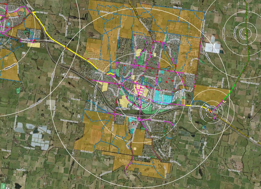
2

Table of Contents

Contents

Executive Summary ................................................................................................................................1

Table of Contents ................................................................................................................................... 2

Background .................................................................................................................................................. 3

Why is a Paths and Trails Strategy needed?.............................................................. 4

What will this Paths and Trails Strategy address? ................................................ 5

How has the Paths and Trails Strategy been developed? ........................ 10

Implementation of the Paths and Trails Strategy ............................................... 16

Baw Baw Shire Council Draft Paths and Trails Strategy – Round 2 Consultation
3

                                                                        The Victoria in Future 2016’ report by the Department of
Background
                                                                        Environment, Land, Water and Planning (DELWP), placed Baw Baw
Baw Baw Population                                                      Shire as the third fastest growing regional area in Victoria. The Baw
Baw Baw Shire is the largest peri-urban municipality in Victoria        Baw Settlement Management Plan projects that Baw Baw will have
covering approximately 4,000-square kilometres and is home to           71,683 residents by 2036.
many diverse industries.                                                Baw Baw Shire’s Strategic Growth Corridor stretches along the
Located approximately 100-kilometres east of the Melbourne CBD,         Princes Freeway taking in seven towns from Longwarry in the west
or one hour’s drive from Melbourne, the Shire is connected by the       to Trafalgar in the east, including the Shire’s growth centres in
Princes Freeway and express rail services to Melbourne’s CBD. The       Drouin and Warragul.
Shire is within commuting distance of the expanding metropolitan        Regional Victoria is in the midst of a population boom driven by
area, and attracts new residents looking to take advantage of the       unprecedented growth in greater Melbourne. Despite the number
available affordable housing, while experiencing a rural township       of people relocating to regional Victoria, infrastructure and
lifestyle.                                                              services are significantly under-resourced. With some regional
Baw Shire has an estimated population of over 50,000 (as of             Councils bracing for their populations to increase by half in just
December 2017), with an estimated overall population growth of          over a decade.
13% between 2011 and 2016. Whilst the overall population has            Along with other fast-growing regional areas such as Surf Coast, Bass
grown 13% during this time, the Princes Highway corridor is             Coast, Golden Plains, Macedon Ranges, Moorabool and Murrindindi, Baw
experiencing much higher population growth; Drouin, for example,        Baw Shire faces a unique challenge in balancing the need to
grew by 27% in that same period.                                        preserve farmland to support agricultural production and the
Outside of metropolitan Melbourne, Baw Baw had the second               need for developments to cater for the spike in population growth.
highest annual population growth of 2.8% behind Surf Coast Shire.       Council must manage growth in a sustainable manner and keep
This is significantly higher than the state average of 1.8 per cent.    up with the demand for infrastructure.

Baw Baw Shire Council Draft Paths and Trails Strategy – Round 2 Consultation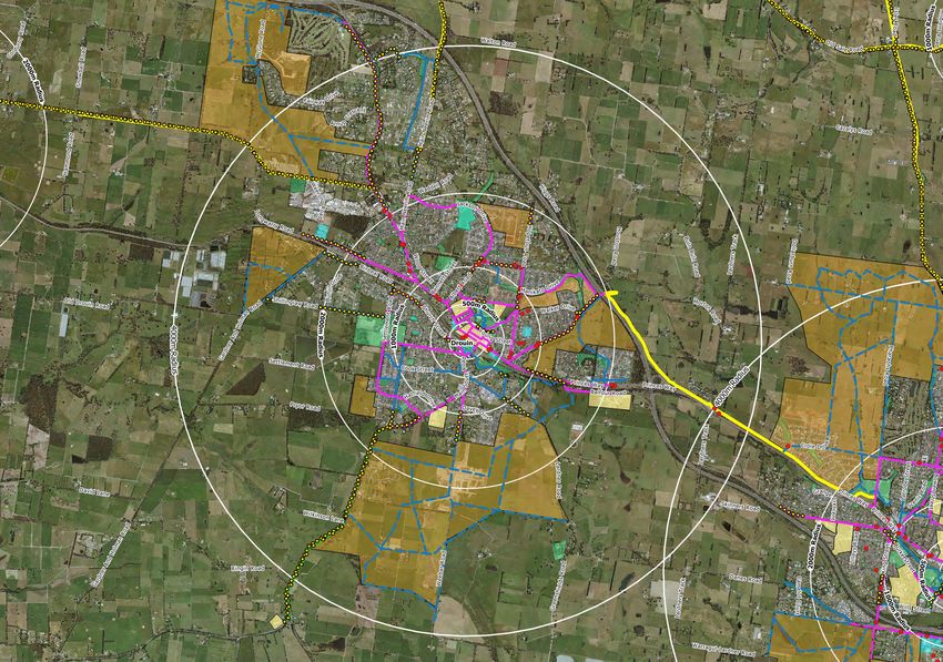
4

Why is a Paths and Trails Strategy needed?
With a rapidly growing population, there is increasing demands and pressure on community infrastructure and services for Baw Baw Shire
Council. While Council has been proactive in planning for population growth, the recent increase in growth has introduced a greater urgency
for many projects to be undertaken in a shorter time frame. This has placed significant financial implications on Council in meeting the
additional costs of bringing forward projects in the current rate capped environment, and at a time when there is increasing pressure for
Council to address the mounting infrastructure gap.

The Paths and Trails Strategy is essential to plan how Council will invest in the construction of paths and trails within the Shire. The Strategy
will prioritise path and trail projects primarily for transport and connectivity to key destinations and public facilities.

Objective of the Strategy
The objectives of the Paths and Trails Strategy are to:

   •   Promote and encourage walking as a sustainable and preferred mode of transport for short trips to work, shops, school and for
       recreation
   •   Provide paths and trails that link key destinations and points of interests such as shops, educational institutions, recreational and
       health facilities, and public transport
   •   Improve the amenity, accessibility and safety of the footpath network so they are accessible for all users
   •   Strengthen existing pedestrian links creating a direct, connected network
   •   Assist in responding to residents’ requests for construction of new footpaths and high expectations for their delivery
   •   Establish criteria to guide the development of new footpaths for the primary and secondary pedestrian network
   •   Include provision in the Long Term Infrastructure Plan to complete the development of the PPN in a financially sustainable manner

Baw Baw Shire Council Draft Paths and Trails Strategy – Round 2 Consultation
5

What will this Paths and Trails Strategy address?
The Paths and Trails Strategy will address the following.

   •   The demand for connectivity for pedestrians and cyclists to key public points of interest in the Shire
   •   The growing demand for new paths and trails to connect to new developments and estates
   •   The demand for path and trail connections between townships and key localities
   •   The need for a prioritisation system for path and trail construction that is consistent, fair and transparent

Council Plan
Council’s vision is to foster happy, healthy people sharing prosperity
and knowledge from living sustainably and in harmony with our rural
identity, thriving villages, productive and inspiring landscapes.

The Council Plan 2017-2021 is founded on four objectives of vibrant
communities, thriving economy, safe and sustainable environments
and organisational excellence. While the Paths and Trails Strategy will
help enhance the overall Council Plan’s four objectives, it will figure
predominantly in delivering on the ‘Vibrant Communities’ and ‘Safe
and ‘Sustainable Environments’ elements.

The strategy has identified a range of themes around path and trail
connections. A major concern is the lack of connections in existing
residential areas in addition to connections from new developments
to key public facilities. The strategy has identified the locations of path
and trail connection gaps and deficiencies. It will focus on prioritising
projects in a fair and transparent manner across the Shire, via five
annual programs as part of the Long Term Infrastructure Plan.

Baw Baw Shire Council Draft Paths and Trails Strategy – Round 2 Consultation
6

The Existing Paths and Trails Network
The existing paths and trails network comprises approximately 450km of Council maintained paths and trails within Baw Baw Shire.

Information pertaining to paths and trails is stored in Council Asset Management System and the                  Pathway Material      Length (km)
Geographical Information System (GIS). Council receives many requests for path and trail                         Concrete Paths           382
connections/improvements. Broad community feedback highlighted the following areas of focus:
                                                                                                                 Asphalt Paths             3.7
   •   Inconsistent footpath networks and gaps in the network                                                    Gravel Paths             54.4
   •   Pedestrians being forced to cross roads as footpaths were only on one side of the road
                                                                                                                 Brick/ Paver Paths        4.8
   •   Lack of DDA compliance
                                                                                                                 Other                      1
   •   Inadequate safe road crossing points and facilities
   •   Lack of footpaths in some areas                                                                           Total                   450km

Identifying Priority Town Walking and Cycling Networks
Council’s priority is to encourage cycling and walking for short local trips as opposed to vehicle use. This will have the benefits of improving
health, reducing the need for additional car parking (including train station parking) and reducing road congestion. Evidence collected
identified a strong need for more emphasis on walking and cycling infrastructure in towns, with infrastructure provision being cited as a
barrier to more people walking and cycling.

Reasonable walking and cycling catchments vary depending on topography, terrain and amenity. For the purpose of setting priorities, the
evidence recommends improvements to walking paths within one kilometre of key town centres and improvements to shared/cycle paths
within two kilometres of key town centres.

The Paths and Trails Strategy will consider walking and cycling routes to town centres from new development to be considered regardless of
the distance to the town centre. Development on the fringe of existing towns should contribute to regional walking and cycling links to offset
the greater reliance on cars that fringe developments tend to have, and its flow on effects such as increased traffic congestion and
increased demand for parking.

Baw Baw Shire Council Draft Paths and Trails Strategy – Round 2 Consultation
7

Promotion of Walking and Cycling in Baw Baw Shire
Council has been involved in the following initiatives to encourage walking. These include:

   •   Promoting recreational walking within the Shire by promoting the Walking and Cycling Trail Maps on Councils website
   •   Supporting the ‘Drouin Tree Walks’ created by the Friends of Drouin Trees
   •   Participation in Walk/Ride to Work Days
   •   Supporting the Walk to School days
   •   Supporting Ride to School days

Baw Baw Shire's two innovative projects 'Active by Design' and 'Two Town Trail' won the 2009 Heart Foundation Local Government Awards,
both at a national as well as state level.

The ‘Active by Design’ project involved developers to create a toolkit so that new housing developments incorporated accessible
destinations and attractive environments. “Baw Baw’s ‘Active by Design’ project is a strong example of how local government can influence
active living through urban planning,” said Heart Foundation (Victoria) Chief Executive Officer at the time.

The 'Two Town Trail' is an 8km trail linking Drouin and
Warragul and is a highly valued community asset. The trail
was built to enable half of the Baw Baw population to walk
or cycle between the two towns and was 20 years in the
making. The project was funded by Vic Roads, Council, the
Department of Planning and Community Development
(DPCD) and the Federal Government, with a total cost of
$1.8 million. Council worked further on beautification of the
trail and gained an additional $95K from the DPCD -
Creating Better Places fund to make the trail an
interesting, safe and visually appealing environment that
encourages physical activity.

Baw Baw Shire Council Draft Paths and Trails Strategy – Round 2 Consultation
8

Economic Development and Tourism
Research from Australia and overseas indicates significant economic and tourism benefits can be derived from a well organised and
maintained paths and trail network. Benefits include expenditure in rural and regional areas, return visits and increased overnight stays by
domestic and international tourists. Council can initiate investment and research into economically viable projects that will provide path and
trail infrastructure for the local community but also provide an income stream for the Shire as part of this strategy and existing tourism
strategies.

As per Council’s Destination Action Plans (Walhalla, Noojee and Yarragon), paths and trails within Baw Baw Shire are a great attraction for
tourists from outside the region. Walhalla and Noojee for example, appeal to many visitors and provide an important gateway to the Loch
Valley, Aberfeldy, Mount Baw Baw and the widely renowned Australian Alpine Walking Tracks.

Recreation
Council adopted the Recreation Strategy 2017-2027 in 2017 which highlighted that 65% of all survey respondents walk for recreation. Walking
and cycling paths, tracks and trails were deemed to be the most popular places to recreate. The need for constructing new or upgraded
walking and cycling paths was identified as one of the top five community priorities.

Studies at the national, state and local level have shown that participation in informal, unstructured recreation is greater than participation in
organised sports.

The development of a Paths and Trails Strategy will address the high level of community demand demonstrated for walking/cycle paths and
opportunities for better connectivity within towns and between towns.

Baw Baw Shire Council Draft Paths and Trails Strategy – Round 2 Consultation
9

The Baw Baw Shire Council Integrated Transport Plan
The Baw Baw Shire Council Integrated Transport Plan 2011 (which is a 10-year plan) identified five key goals to implement as follows:

   1.   Improve town and inter-town walking and cycling networks
   2.   Improve public transport services
   3.   Increase amenity, efficiency and safety of roads and parking
   4.   Plan mobility for an ageing population
   5.   Base land-use controls on sustainable transport outcome

This Paths and Trails Strategy assists Council in achieving Goal 1 improve town and inter-town walking and cycling networks of the Integrated
Transport Plan. The tendency to walk for transport, physical activity and recreation is influenced by several variables, including the existence
of well-maintained footpaths, shared paths, walking tracks and trails, street design, particularly connectivity; urban amenity; safety and the
presence of local destinations within walking distance. In the Shire’s transport system, walking and cycling play an important role and
provide viable alternatives to motor vehicle usage, particularly when trips are less than 2km (or within a 20-minute walk).

Smart Roads
SmartRoads is an approach used by VicRoads that manages competing interests for limited space and time in the road network by giving
priority use of the road to transport modes, both in different parts of the network and at different times of the day. SmartRoads provides a
long term approach for operating Victoria’s road network that makes it more efficient and safer, whilst supporting the development of
activity centres and key destinations as places where people live and work.

The guiding principles of the SmartRoads plan for Victoria SmartRoads recognise the increasing role that buses, trams, trucks and bicycles
play in moving people and goods around the network. It also recognises that good access for pedestrians needs to be a key element of the
transport system.

SmartRoads have identified locations and routes that are key walking and cycling routes. These routes have been considered and included
in the identification of important routes for the development of this paths and trails strategy. These locations will be prioritised for the path
and trail network and included as key strategic routes.

Baw Baw Shire Council Draft Paths and Trails Strategy – Round 2 Consultation
10

How has the Paths and Trails Strategy been developed?
Paths and trails play a significant role within the Baw Baw Shire, providing a means of access to
community facilities, services, public transport and open space.

To enable Council to plan where paths and trails should be built in the future, a more proactive and
strategic approach to the planning, design and construction of pathways in Baw Baw Shire is needed.

The Principal Pedestrian Network (PPN)
Transport for Victoria created a Principal Pedestrian Network (PPNs) model which enables effective
strategic network planning for pedestrians and cyclists in the broader context of transport and land
use planning.

A PPN is a designated mapped network of routes which support walking trips in and around key
destinations. The PPN methodology provides local government with a tool to develop a framework and
evidence-based approach for the inclusion of pedestrian needs in transport and planning decisions
by:

      •   Mapping pedestrian movements in their municipalities and identifying priority routes;
      •   Planning for and prioritising infrastructure improvements, to encourage and support more
          walking; and
      •   Working with the Victorian Government (e.g. Regional Roads Victoria, Transport for Victoria, etc.) to ensure pedestrians are
          appropriately prioritised in Victoria’s transport planning and investment

PPNs aim to identify routes within the built environment that are likely and have the potential to carry more pedestrians walking to key
destinations and improve the quality of these routes to encourage more walking. The overarching objective of developing a PPN is to provide
pedestrians with a higher level of service by making the shortest route also the highest quality route, and thereby encouraging walking trips.

The objective for Council is to extend pathways and fill gaps in the PPN by building key footpath links based on pedestrian desire lines. If a
street is not shown to have a future footpath, in most situations there will be a nearby neighbouring street that will provide the footpath link
for that part of the network. The Principal Pedestrian Network consists of a total of 50km of missing pathways and 246km of missing inter-
town connections across the Shire.

Baw Baw Shire Council Draft Paths and Trails Strategy – Round 2 Consultation
11
Guiding Principles for the PPN
The following principles have been considered that drive the future direction of the provision of pathway facilities and infrastructure to
ensure a strategic and consistent approach to the construction of new pathways in Baw Baw Shire.
• Recognise key destinations and points of interest that generate pedestrian activity and aim to service these with a path
• Construct paths on at least one side of the road for the primary and secondary network
• Bus routes shall have additional connecting paths on both sides as required to ensure DDA compliance (assessed on a case by case
basis)
• Arterial roads shall have paths on both sides of the road to limit the need to cross the road multiple times, where topography and
space allow (assessed on a case by case basis)
• Safe crossing points shall be included as part of projects, as required
Methodology for the development of the PPN
As part of the development of the PPN for Baw Baw Shire, the following methodology will be applied.
1. Review existing strategies, plans and policies for previous work completed relating to pedestrian accessibility (including previous
community consultation such as the Community Plans)
2. Identification of key destinations or points of interests within each township
3. Setting of a walkable distance from these key destinations (up to 2km)
4. Determination of a method to allow community requests to influence priorities whilst still delivering the principal pedestrian network
5. Identification and mapping of the key Principle Pedestrian Network which connects people to the key destinations within the relevant
township (Primary and Secondary Network)
6. Community validation of the proposed primary and secondary path network
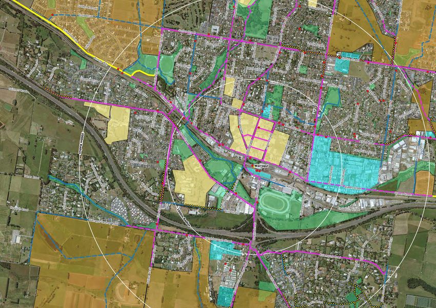
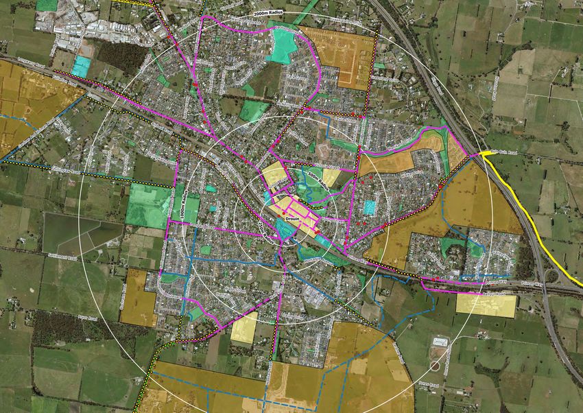
Baw Baw Shire Council Draft Paths and Trails Strategy – Round 2 Consultation12 Mapping the PPN for Baw Baw Shire As part of the Strategy, the PPN was mapped for the following townships (See Appendix 1). The townships and key localities have been categorized based on the following: • Population (per postcode) • The number and location of public points of interest • The size and shape of the urban sprawl • The four categories will also correspond to the capital works programs where individual projects will compete for funding Major Towns Warragul Drouin Yarragon* Trafalgar Longwarry Neerim South Minor Towns Thorpdale Darnum Willow Grove Rawson Buln Buln Villages Jindivick** Rokeby Nilma Neerim Junction Nayook Erica Tourist Towns Noojee Walhalla *Note: Although considered a key tourist town in the Baw Baw Shire Council Economic Development Strategy 2018-2021, Yarragon has been categorised as a major town here due to the size of its population, urban sprawl and residential development. **The population of Jindivick is higher than Rawson, but its urban sprawl is significantly less so has been categorised as a village. In mapping the PPN, there were several considerations in where the networks would be located. Not every path and trail will be located within road reserves, and they may be located along parks and reserves. Several stages were undertaken to map the PPN. Baw Baw Shire Council Draft Paths and Trails Strategy – Round 2 Consultation
13

Stage 1 – Strategic links via the existing road network

The PPN proposed for each locality has predominantly been based around the existing road network within the public road reserve. This is
due to the available space for paths and trails and is generally pedestrians’ preferred path of travel as it is the most direct route.

                                  Diagram 1 – Stage 1: Example map of the PPN along the road network in the road reserve

                                               Pink Lines – Primary Network Blue Lines – Secondary Network

Baw Baw Shire Council Draft Paths and Trails Strategy – Round 2 Consultation
14
Stage 2 - Strategic links within Public Reserves and Parks Stage 3 - Inter-Township Strategic Links for PPN Analysis
Pathway networks and linkages through public reserves and open Inter-town networks and linkages for tourism and recreation have
spaces have been identified and mapped. There are many public been identified building upon the previous work completed by
parks, reserves and open spaces that have existing pathways that Council ‘Bicycle and Walking Paths Development Plan 1998 . This
provide important links for pedestrians and form part of the body of work was reviewed for the development of the Paths and
primary and secondary networks. Trails Strategy. Alignments shown in the diagrams are indicative
only and subject to further detailed investigation and design.
Diagram 2 – Stage 2: Example map of the PPN in public reserves and open spaces Diagram 3 – Stage 3: Example map of the PPN Inter-Town Connections
Pink Lines – Primary Network Blue Lines – Secondary Network Yellow Lines – Primary Priority Network
Green Lines – Secondary Priority Network
Baw Baw Shire Council Draft Paths and Trails Strategy – Round 2 Consultation15
A Paths and Trails Prioritisation System
Council’s existing priority system, adopted in 2013/14, evaluated projects using the following
criteria.
• Pedestrian Safety
o Road carriageway width, sight distance, speed limit, daily traffic volume, parking
demand infringing access, alternative access, crash history
• Public Response
o Requests/petitions, disabled and elderly access
• Social & Economical Factors
o Surrounding land use, adjacent activity node, planned development, socio-
economic status
• Alignment to Council Objectives, Major Strategies and Policies
Projects evaluated against the above components were prioritised with the top projects predicted to be the most beneficial in terms of
strategic importance, and economic and social value. Under this prioritisation framework, projects were often considered on a reactive,
request-based approach. See Appendix 2 for detail of the Paths and Trails Scoring Matrix Evaluation Criteria.
Additions to the Footpath Prioritisation Tool (Matrix)
While it was acknowledged that the matrix provides a very thorough analysis of scoring pathway projects in a consistent manner throughout
the Shire, the prioritisation tool matrix was reviewed during the FY 2018/19 and attributes have been added to the matrix to categorise and
distinguish major towns, minor towns, villages and inter-town connections. A further attribute which highlights if requests from the
community are located along a primary or secondary pathway network of the PPN have been added.
To transform the prioritisation of projects to a strategic and pro-active approach, the missing gaps within the existing primary and
secondary pathway networks have been identified and added into the prioritisation matrix.
Baw Baw Shire Council Draft Paths and Trails Strategy – Round 2 Consultation16 Implementation of the Paths and Trails Strategy The Long Term Infrastructure Plan Of the Principle Pedestrian Network, both primary and secondary networks, there is a total of 50km which require construction within townships, at an estimated cost of $10.2M. The desired trail network across the Shire also consists of the following trails requiring construction: • 50km of primary inter-town trail connections ($11.3M) • 196km of secondary inter-town trail connections ($31.6M) Having now identified the PPN, the Strategy will allow Council to better plan and prepare the annual budgets to prioritise key path and trail projects to include into the Long Term Infrastructure Plan. Appendix 3 outlines the detail of the missing Paths and Trails within the PPN. The diagram below demonstrates Council’s process structure for the annual paths and trails program. Baw Baw Shire Council Draft Paths and Trails Strategy – Round 2 Consultation
17

Community Engagement
Whenever a construction project is planned, consideration needs to be taken to engage the community to ensure there is public support
and awareness for the construction of a footpath/shared path and provide them with an opportunity to provide input into the decision-
making process.

Funding

Footpaths located within Council Road Reserves are generally constructed at Councils cost with the timing of works subject to available
funding in the annual capital works program. Paths and trails that are part of the PPN can be considered for external funding applications
and opportunities. The timing of works would be subject to available funds in the capital works budget and the timing of external grant
funding opportunities.

Council can, in the future, consider the implication of special charge schemes where abutting property owners may be willing to contribute
towards part of the cost of construction for projects that are not high priority with the paths and trails prioritisation tool and thereby raise the
priority of the project within the matrix.

The construction of some pathways that address significant existing road safety problems or improve pedestrian and cycling network and
access can also be fully or part funded by organisations such the Transport Accident Commission, Regional Development Victoria, Transport
for Victoria, VicRoads, Public Transport for Victoria, Regional Roads Victoria etc. Many recreation and passive use trails may be funded
through economic development funding from State and Federal Government funding.

Baw Baw Shire Council Draft Paths and Trails Strategy – Round 2 Consultation
Appendix 1 – PPN Methodology and Maps

                             Appendix 1 – PPN Methodology
                             and Maps
                                                specifically, the following documents were       •   Warragul Town Centre Masterplan May
                                              reviewed:                                              2011
                         Principal
As per the Methodology adopted     Pedestrian Network
                               by Council
                                                                                                 •   Walk Cycle Baw Baw 2014
for the development of the Paths and Trails
                                                   •    The Council Plan 2017-2021               •   Bike it Baw Baw
Strategy, the following activities were                (adopted by Council in 2017)              •   Transport for Victoria – Guidelines for
conducted:                                         •   The Visit Baw Baw Destination                 developing Principal Pedestrian Networks
                                                       Branding Strategy (adopted by
                                                                                                     (May 2015)
Step 1: Review existing strategies, plans and          Council in 2014)
                                                                                                 •   Community Plans
policies for previous work completed               •   The Economic Development
                                                                                                 •   Reserve Master Plans
relating to pedestrian accessibility                   Strategy 2014-2018 (adopted by
                                                                                                 •   Health and Well Being Strategy
                                                   •   Council in 2014)
To ensure that the PPN would balance                                                             •   Victoria Walks Safer Road Design for
                                                   •   Baw Baw Shire Recreation Strategy 2017-
previous work completed around paths and                                                             Older Pedestrians – 2016
                                                       2027
trails and to plan pedestrian to/from new                                                        •   Baw Baw Shire Council Settlement Plan
                                                   •   Baw Baw Shire Road Safety Strategy
developments (residential growth areas), a                                                       •   Victorian Transport Plan
                                                       2018-2022
wide range of documents were reviewed.                                                           •   Active by Design (2008)
                                                   •   Improving the Pedestrian Environment in
These documents include (but are not                                                             •   Infrastructure Design Manual (IDM)
                                                       Six Towns of Baw Baw Shire
limited to) population growth and land use                                                       •   Civic Park Drouin Master Plan
                                                   •   Integrated Transport Plan (ITP) – 2011-
planning documents for the regional as well                                                      •   Civic Park Warragul Master Plan
                                                       2021
as for specific localities. Land use planning                                                    •   Baw Baw Shire Walking and Cycling Trail
                                                   •   Warragul and Drouin Precinct Structure
documents referenced included precinct                                                               Maps
                                                       Plans
structure plans for both Warragul and              •   Warragul and Drouin Developer
                                                                                                 •   Drouin Recreation Plan
Drouin, Yarragon 2030, Trafalgar 2030. More            Contribution Plans
                                                                                                 •   Public Health and Wellbeing Plan 2013-
                                                                                                     2017
                                                   •   Drouin Town Centre Strategy 2010

                                                                                                                                      1|Page
Appendix 1 – PPN Methodology and Maps
• Rural Recreation Reserve Master Plans • Trafalgar 2030 • Yarragon and Surrounds Destination
Stage 2 • Yarragon 2030 Action Plan 2018
• Rural Recreation Reserve Master Plans – • Walhalla and Mountain Rivers • Gippsland Regional Growth Plan 2014
Final report December 2014 Destination Plan 2018 • Baw Baw Shire Settlement Plan 2013
• Warragul Outdoor Recreation Plan – • Noojee and Surrounds Destination Plan
review Report December 2014 2018
Step 2: Identify key destinations or points of interests within the township
For each township, key destinations and pedestrian generating public amenities have been located and mapped. Primary destinations include
shopping precincts, town centres and schools (primary and secondary schools). Secondary destinations include all other public amenities such
as reserves and open space, other points of interests (such that would generate pedestrian activity).
The location of bus stops has also been mapped to determine the alignment of the PPN.
Step 3: Set walkable distance from these key destinations (up to 2km)
The PPN network has been focused around a 2km radius of the town centres of the larger townships (however as required the radius is
extended to the boundaries of townships to connect pedestrians from the urban fringes and new developments).
Step 4: Identify and map key Principle Pedestrian Network that connect people to the key destinations (Primary and Secondary)
The primary and secondary networks were mapped in three stages – through road reserves, through reserves and open spaces, and inter-
town connecting trails.
Step 5: Community validation of the proposed primary and secondary path network
Once the PPN was mapped, the community was provided with an opportunity to provide feedback (See Appendix 5).
Step 6: Determine method to still allow community requests to influence primary path network priorities whilst focus is on delivering the
principal pedestrian network
Whilst a priority system has been formulated, customer requests are a strong factor in prioritising path and trail projects because it provides
evidence of its usage. No request is ever invalid.
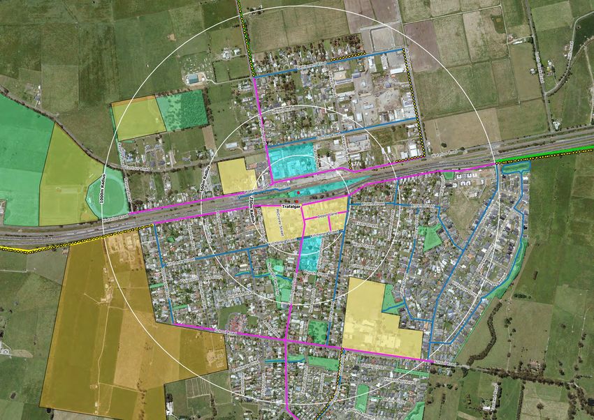
2|PageLegend - Drouin
Primary Network
PSP
Secondary Network
PSP
Town Gaps
Future Development
Reserves & Open Space
Schools & Shops
Point of Interest
Bus Stop
Priority Intertown Linkage
PSP
Secondary Intertown Linkage
PSPLegend - Drouin
Primary Network
PSP
Secondary Network
PSP
Town Gaps
Future Development
Reserves & Open Space
Schools & Shops
Point of Interest
Bus Stop
Priority Intertown Linkage
PSP
Secondary Intertown Linkage
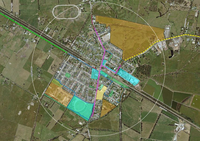
PSPLegend - Longwarry
Primary Network
PSP
Secondary Network
PSP
PPN Missing Paths and Trails
Future Development
Reserve
Reserves & Open Space
Schools & Shops
Point of Interest
Bus Stop
Priority Intertown Linkage
PSP
Secondary Intertown Linkage
PSPLegend - Neerim South
Primary Network
PSP
Secondary Network
PSP
PPN Missing Paths and Trails
Future Development
Reserves & Open Space
Schools & Shops
Point of Interest
Bus Stop
Priority Intertown Linkage
PSP
Secondary Intertown Linkage
PSPLegend - Trafalgar
Primary Network
PSP
Secondary Network
PSP
PPN Missing Paths and Trails
Future Development
Reserves & Open Space
Schools & Shops
Point of Interest
Bus Stop
Priority Intertown Linkage
PSP
Secondary Intertown Linkage
PSPLegend - Warragul
Primary Network
PSP
Secondary Network
PSP
PPN Missing Paths and Trails
Future Development
Reserves & Open Space
Schools & Shops
Point of Interest
Bus Stop
Priority Intertown Linkage
PSPLegend - Warragul
Primary Network
PSP
Secondary Network
PSP
PPN Missing Paths and Trails
Future Development
Reserves & Open Space
Schools & Shops
Point of Interest
Bus Stop
Priority Intertown Linkage
PSPLegend - Yarragon
Primary Network
PSP
Secondary Network
PSP
PPN Missing Paths and Trails
Future Development
Reserves & Open Space
Schools & Shops
Point of Interest
Bus Stop
Priority Intertown Linkage
PSP
Secondary Intertown Linkage
PSPLegend - Buln Buln
Primary Network
PSP
Secondary Network
PSP
PPN Missing Paths and Trails
Future Development
Reserves & Open Space
Schools & Shops
Point of Interest
Bus Stop
Priority Intertown Linkage
PSP
Secondary Intertown Linkage
PSPLegend - Darnum
Primary Network
PSP
Secondary Network
PSP
PPN Missing Paths and Trails
Future Development
Reserves & Open Space
Schools & Shops
Point of Interest
Bus Stop
Priority Intertown Linkage
PSP
Secondary Intertown Linkage
PSPLegend - Rawson
Primary Network
PSP
Secondary Network
PSP
PPN Missing Paths and Trails
Future Development
Reserves & Open Space
Schools & Shops
Point of Interest
Bus Stop
Priority Intertown Linkage
PSP
Secondary Intertown Linkage
PSPLegend - Thorpdale
Primary Network
PSP
Secondary Network
PSP
PPN Missing Paths and Trails
Future Development
Reserves & Open Space
Schools & Shops
Point of Interest
Bus Stop
Priority Intertown Linkage
PSP
Secondary Intertown Linkage
PSPLegend - Willow Grove
Primary Network
PSP
Secondary Network
PSP
PPN Missing Paths and Trails
Future Development
Reserves & Open Space
Schools & Shops
Point of Interest
Bus Stop
Priority Intertown Linkage
PSP
Secondary Intertown Linkage
PSPLegend - Erica
Primary Network
PSP
Secondary Network
PSP
PPN Missing Paths and Trails
Future Development
Reserves & Open Space
Schools & Shops
Point of Interest
Bus Stop
Priority Intertown Linkage
PSP
Secondary Intertown Linkage
PSPLegend - Jindivick
Primary Network
PSP
Secondary Network
PSP
PPN Missing Paths and Trails
Future Development
Reserves & Open Space
Schools & Shops
Point of Interest
Bus Stop
Priority Intertown Linkage
PSP
Secondary Intertown Linkage
PSPLegend - Nayook
Primary Network
PSP
Secondary Network
PSP
PPN Missing Paths and Trails
Future Development
Reserves & Open Space
Schools & Shops
Point of Interest
Bus Stop
Priority Intertown Linkage
PSP
Secondary Intertown Linkage
PSPLegend - Neerim Junction
Primary Network
PSP
Secondary Network
PSP
PPN Missing Paths and Trails
Future Development
Reserves & Open Space
Schools & Shops
Point of Interest
Bus Stop
Priority Intertown Linkage
PSP
Secondary Intertown Linkage
PSPLegend - Nilma
Primary Network
PSP
Secondary Network
PSP
Future Development
Reserves & Open Space
Schools & Shops
Point of Interest
Bus Stop
Priority Intertown Linkage
PSP
Secondary Intertown Linkage
PSPLegend - Rokeby
Primary Network
PSP
Secondary Network
PSP
PPN Missing Paths and Trails
Future Development
Reserves & Open Space
Schools & Shops
Point of Interest
Bus Stop
Priority Intertown Linkage
PSP
Secondary Intertown Linkage
PSPLegend - Noojee
Primary Network
PSP
Secondary Network
PSP
PPN Missing Paths and Trails
Future Development
Reserves & Open Space
Schools & Shops
Point of Interest
Bus Stop
Priority Intertown Linkage
PSP
Secondary Intertown Linkage
PSPLegend - Walhalla
Primary Network
PSP
Secondary Network
PSP
PPN Missing Paths and Trails
Future Development
Reserves & Open Space
Schools & Shops
Point of Interest
Bus Stop
Priority Intertown Linkage
PSP
Secondary Intertown Linkage
PSPInter –Town Connections
Inter-Town PPN
*Indicative alignments shown
 These are subject to further detailed
 investigation and design

Priority Intertown Linkage

Secondary Intertown Linkage

       Missing Inter-Town Paths
       (To be constructued)
Appendix 2 - Paths and Trails Priority Matrix
Appendix 2 – Paths and Trails Priority Matrix
Scoring Criteria
Scoring System
Criterion Justification 100
Max Score
Social Impact - Pedestrian Safety
Road Carriageway Width Roads with multiple lanes or narrow roads are Multi-lane roads 4
more hazardous to pedestrians. Those wishing
Narrow < 6m 3
to walk parallel to traffic on a narrow road are
therefore closer to passing traffic while multi- Medium 6-6.9m 2
lane roads can be unsafe to traverse.
Moderate 7m-7.9m 1
Wide > 8m 0
Sight Distance Visibility for pedestrians and drivers can be Severe Restrictions 5
reduced due to road geometry. This can include
crests in vertical alignment or sharp bends, Serious Restrictions 3
intersections near footpaths etc Moderate
2
Restrictions
Few Restrictions 1
No Restrictions 0
Speed Limit The risk to pedestrian safety increases with 80km/h or > 6
speed
60km/h - 70km/h 4
50km/h 2
40km/h 0
Daily Traffic Volume Increases in traffic volume results in increased >10000 vpd 10
likelihood of accident as pedestrians forced to
use road reserve or shoulder 5001-9999 vpd 8
3001-5000 vpd 6
2001-3000 vpd 5
1001-2000 vpd 4
501-1000 vpd 2Appendix 2 - Paths and Trails Priority Matrix
Criterion Justification Scoring System
Alternative Access Is alternative access available off the road Concrete/Asphalt
reserve and can be utilized by user group (I.e. path on other side of 0
Consider if large majority of school children who road < 2500vpd
lack road sense or elderly/disabled). Ignore Gravel Path on same
access on other side of multi-lane road or or other side of road 1
roads with volumes > 10000 vpd or speed limit of < 2500 vpd
100km/h. Concrete/Asphalt
path on other side of 2
road > 2500 vpd
Both Nature Strip 4
One Nature Strip 6
None or limited 10
Crash History Yes 10
Has there been any recorded pedestrian vs
vehicle accidents recorded No 0
Social Impact - Public Response/ Demand
Requests & Petitions Have CRM Requests / Recfind or petitions been Large Petition > 200
4
received by council. The number of requests or Signatures
signatures on a petition may be indicative of Medium Petition 100-
community support. CRM Requests weighted 4
199 Signatures
higher than petitions
Small Petition 40-99
3
Signatures
Minor PetitionAppendix 2 - Paths and Trails Priority Matrix
Criterion Justification Scoring System
Environmental Impact
Vegetation Removal Will design require vegetation to be removed? Significant Species -5
Only score those which would detrimentally
effect environment/amenity The type and Extensive -3
quantity will determine the extent of scoring. Moderate -2
Example of significant species; Strzelecki Gum
Low -1
None or limited 0
Earthworks & Terrain The type of terrain will influence construction Extensive
-3
costs. I.e. steep embankments or crossfalls will Earthworks/Cross fall
require retaining walls etc. Extensive earthworks Significant
-2
will reduce cost effective nature of footpath Earthworks/Cross fall
while reducing amenity Minor Earthworks/
-1
Cross fall
Negligible
0
Earthworks/Cross fall
Social/Economic Impact
Surrounding Zone The density and type of zoning will influence the Residential 1 Zoning 5
level of usage. Disregard criterion if nearby
school or major community facility Industrial Zoning 2
Low Density
0
Residential
Disregard As School
5
Nearby
Activity Node 1 Will the path serve an adjacent or nearby facility Primary School 10
that attracts pedestrians or caters for a
significant number of them. Select highest score Secondary School 8
applicable. If facility not listed pick node with Shopping Centre /
7
similar pedestrian activity. Nearby facility Railway Station
deemed to be applicable if within 250m buffer
Community Facility
zone of footpath length
(high use i.e. parks 6
rec trail)
Large Office
Complex or Tertiary 5
Institute
Community Hall,
Senior Citizen, Scout 4
Hall etc.
Local Shops or Child
3
Care Centre
Local Medical Centre
2
or Bus Stop
No 0
3|PageAppendix 2 - Paths and Trails Priority Matrix
Criterion Justification Scoring System
Activity Node 2 Will the path serve a secondary facility or bus Primary School 10
stop? Select highest score applicable. If facility
not listed pick node with similar pedestrian Secondary School 8
activity. Nearby facility deemed to be applicable Shopping Centre /
7
if within 500m buffer zone of footpath length Railway Station
Community Facility
(high use i.e. parks 6
rec trail)
Large Office
Complex or Tertiary 5
Institute
Community Hall,
Senior Citizen, Scout 4
Hall etc.
Local Shops or Child
3
Care Centre
Local Medical Centre
2
or Bus Stop
No 0
Development Area Is there any future or current development Major Subdivision or
which otherwise would cause increase 4
Development
pedestrian usage of footpath. Do not include
High Use Activity
footpath sections otherwise planned for 3
Node
construction in new development. This includes
Moderate Use
subdivisions and major capital projects which 2
Activity Node
would increase pedestrian usage
Low Use Activity
1
Node
Socio Economic Status What is the status of the beneficial area. Are Very Low (1st Deciles) 6
these people more inclined to use the path as a
result of this? Use SEIFA Maps. Low (2nd Deciles) 4
Medium (3rd-6th
2
Deciles)
High (7th-10th
0
Deciles)
Council Objectives, Major Strategies & Policies
Council Policies & Does the project specifically align with the key Aligns with >4
3
Strategies components of the denoted strategies.* documents
Aligns with 3-4 listed
2
documents
Aligns with 1-2 listed
1
documents
No 0
4|PageAppendix 3 - Existing Gaps
Appendix 3
Existing Gaps
The Primary Network
Assuming that the paths and trails program to be constructed in FY 2018/19 is delivered, the remaining principal pedestrian network for the
primary network consists of the following:
• 29.5 km of existing missing gaps within the primary network which need to be designed and constructed.
• The construction costs would cost approximately $6.5M
In the current FY 2018/19, there are a two inter-town connection projects that are being designed which were estimated to have construction cost
of approximately $2M in total where external funding would need to be sought.
Please see the table below outlining missing pathways within the primary network for each program:
1|PageAppendix 3 - Existing Gaps
Table 1 Primary Network – Missing Paths and Trails
Program Townships Km Total Km $ Estimated Cost Total $ Estimated Cost
Warragul 5.9 $1,400,000
Drouin 9.05 $2,330,000
Yarragon 1.2 $192,000
Major Towns 18.35 $4,456,000
Trafalgar 0.15 $130,000
Longwarry 0.8 $130,000
Neerim South 1.26 $274,000
Thorpdale 0.27 $45,000
Darnum 2.43 $504,000
Major Towns Willow Grove 0.99 5.9 $160,400 $1,037,400
Rawson 0.77 $101,000
Buln Buln 1.4 $227,000
Jindivick 0.655 $94,000
Rokeby 0.645 $93,000
Nilma 0 $0
Villages 3.3 $525,000
Neerim Junction 0.62 $120,000
Nayook 0.54 $78,000
Erica 0.86 $140,000
Noojee 0.945 $153,000
Tourist Towns 2 $452,000
Walhalla 1.09 $299,000
29.5 $6,468,400
2|PageAppendix 3 - Existing Gaps
The Secondary Network
Table 2 Secondary Network – Missing Paths and Trails
Assuming that the paths program to be
Total
designed or constructed in FY 2018/19 is Program Townships Km $ Estimated Cost Total $ Estimated Cost
Km
delivered, the remaining principal
Warragul 4.1 $1,000,000
pedestrian network for the secondary
Drouin 2.6 $523,000
network consists of the following:
Yarragon 1.7 $280,000
Major Towns 12.4 $2,477,500
• 21 km of existing missing gaps Trafalgar 3.3 $543,000
within the secondary network which Longwarry 0.38 $61,500
need to be designed and Neerim South 0.32 $70,000
constructed. Thorpdale 0.66 $107,000
• The construction costs would cost Darnum 0.35 $57,000
approximately $3.7M Major Towns Willow Grove 0.45 2.5 $55,000 $386,000
Rawson 0 $0
Please see the table below outlining the
Buln Buln 1 $167,000
missing pathways within the secondary
Jindivick 0 $0
network for each program:
Rokeby 0.37 $53,000
Nilma 1.65 $120,000
Villages Neerim 5.8 $757,000
0 $0
Junction
Nayook 1.9 $422,000
Erica 1.9 $162,000
Noojee 0.17 $28,000
Tourist Towns 0.4 $118,000
Walhalla 0.2 $90,000
21.1 $3,738,500
3|PageAppendix 3 - Existing Gaps
The Inter-Town Trail Network
Primary Priority Routes
Table 3 Inter - Town Priority Network – Missing Paths and Trails
$ Estimated Total $ Estimated
Program Townships Km Total Km
Cost Cost
Yarragon to Trafalgar 6.7 $1,206,000
Erica to Rawson 4.7 $1,130,000
Brandy Creek to Buln Buln 4.6 $830,000
Inter Town Darnum to Yarragon 5 $1,350,000
49.4 $11,332,000
Connections Warragul to Rokeby 7 $1,272,000
Drouin to Drouin West 9 $1,944,000
Nilma to Darnum 4.3 $1,000,000
Drouin to Longwarry 8.1 $2,600,000
Note: Costing is based on L/m for concrete/gravel. No additional costs considered yet for other structures
4|PageAppendix 3 - Existing Gaps
Secondary Priority Routes
Table 4 Inter - Town Secondary Network – Missing Paths and Trails
Total $ Estimated Total $ Estimated
Program Townships Km
Km Cost Cost
Trafalgar to Thorpdale 6.7 $1,447,200
Trafalgar to Moe 8 $1,728,000
Trafalgar to Willow Grove 20 $4,320,000
Willow Grove to Moe 19 $4,104,000
Willow Grove to Fumina South 21 $4,536,000
Willow Grove to Blue Rock Dam 10 $2,160,000
Willow Grove to Buln Buln 30 $4,320,000
Inter Town
Nilma to Buln Buln 10 196.2 $1,440,000 $31,616,200
Connections
Neerim South to Jindivick 7 $1,000,000
Jindivick to Labertouche 18 $2,600,000
Drouin to Drouin South Primary School 4 $1,728,000
Fumina South to Noojee 30 $432,000
Noojee to Neerim Junction 5 $720,000
Neerim Junction to Neerim 6 865,000
Neerim Junction to Glen Nayook 1.5 $216,000
Note: Costing is based on L/m for concrete/gravel. No additional costs considered yet for other structures
5|PageYou can also read