Draft Whangamata Harbour Plan - Looking forward to a healthier harbour Environment Waikato Internal Report 2007/14
←
→
Page content transcription
If your browser does not render page correctly, please read the page content below
1

Environment Waikato Internal Report 2007/14

Draft
Whangamata Harbour Plan
Looking forward to a healthier harbour

www.ew.govt.nz
Prepared by:
Peter Singleton

For:
Environment Waikato
PO Box 4010
HAMILTON EAST

June 2007

Document #: 1037721
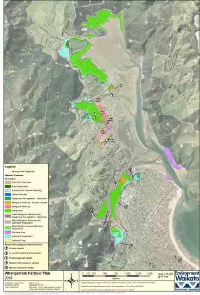
Table of Contents
Executive summary iii
1 Introduction 1
2 Integrated management for Whangamata Harbour 1
2.1 Visions and goals for Whangamata's harbour and catchment 2
2.2 Significance of Whangamata Harbour to Hauraki iwi 4
2.3 Management initiatives relating to the Whangamata Harbour and
catchment 5
3 Issues and action 6
3.1 Layout of the issues and action section 6
Issues 6
Evaluation 6
What is happening 6
What needs to be done 6
3.2 Water quality 6
3.2.1 Issues 6
3.2.2 Evaluation 7
3.2.3 What is happening 13
3.2.4 What needs to be done 15
3.3 Habitat 15
3.3.1 Issues 16
3.3.2 Evaluation 19
3.3.3 What is happening 31
3.3.4 What needs to be done 36
3.4 Sedimentation and flooding 37
3.4.1 Issues 37
3.4.2 Evaluation 38
3.4.3 What is happening 44
3.4.4 What needs to be done 46
3.5 Recreation, boating, access and views 48
3.5.1 Issues 48
3.5.2 Evaluation 48
3.5.3 What is happening 51
3.5.4 What needs to be done 52
4 An integrated plan 53
4.1 Integrating actions in the catchment and harbour 53
4.1.1 Prioritisation of issues 53
4.1.2 Actions 59
4.1.3 Whangamata Harbour management area maps 66
5 Public participation 70
6 Milestones 73
Appendix I 74
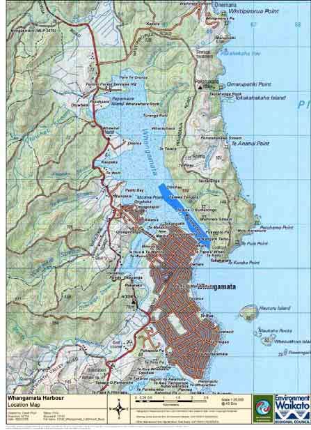
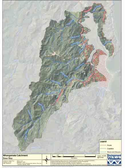
Whangamata catchment map 75
Whangamata locations map 76
Whangamata catchment – Land clearance 77
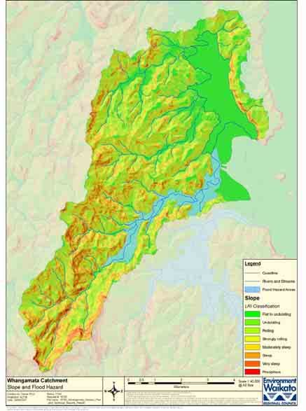
Whangamata catchment – Slope and flood hazards 78
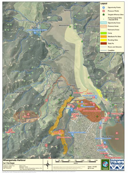
Whangamata catchment – Iwi heritage 79
Whangamata catchment – Land cover 80
Whangamata catchment – Targeted sites – the ‘eight hectares’ of initially
selected mangrove removal sites identified by Environment Waikato in
2007 81
Appendix II Regulatory context 82
Regulatory context 82
Resource Management Act 1991 (RMA) 82
Statutory RMA policy documents affecting the management of Whangamata
Harbour 82
Progression of resource management planning 82
Doc # 1037721 DRAFT DOCUMENT Page i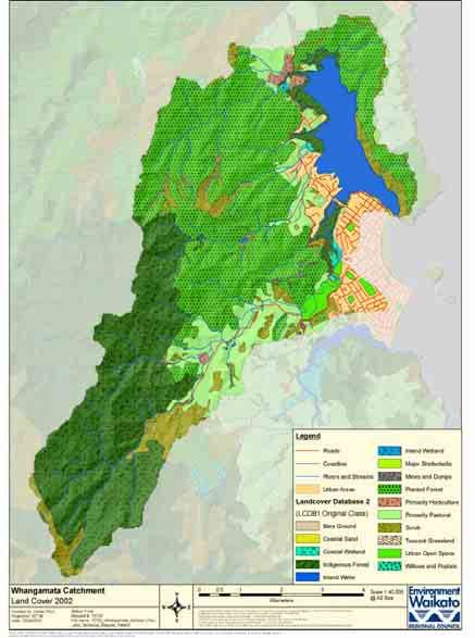
Other agency roles                                                              82
   Local Government Act 2002                                                         83
   Spatial jurisdictions for regulation                                              83
   Other management mechanisms                                                       83

Views, moorings, recreation, clean water and shellfish gathering are all important uses
of Whangamata Harbour. (photo : John Barran)

Page ii                               DRAFT DOCUMENT                       Doc # 1037721
Executive summary
The Draft Whangamata Harbour Plan is a non-statutory document developed in
cooperation with the Department of Conservation (DOC), Forest & Bird, iwi and
Thames-Coromandel District Council. It also draws on work by other groups such as
Whangamata Harbour Care.

This document gives an overview of the issues facing the harbour, what could be done
to address them and how we could work together to ensure the community’s vision for
the harbour is achieved. The possible actions outlined in this plan have been prioritised
to help guide work programmes and funding applications. The plan also recognises
that the harbour is affected by what is happening in its 'catchment' (the land
surrounding the harbour) and that both need to be managed together. Given this,
Environment Waikato has also prepared a Draft Whangamata Catchment Management
Plan 20071 which sets out the priority works we propose to carry out to address the
sedimentation and flooding issues identified in the harbour plan.

The key concerns and risks to the harbour covered in this plan are grouped into four
core issues.

x   Water quality.
x   Habitat.
x   Sedimentation and flooding.
x   Recreation, boating, access and views.

A major issue affecting the long-term health of the harbour concerns sedimentation.
This is caused by soil settling into the harbour and waterways as mud after being
washed down from surrounding land by rainfall. Although sedimentation and erosion
are essentially natural processes, people’s land use activities (for example, through
urban development and agricultural activities like forestry and farming) can increase
how much soil is moved in this way. Contaminants from the land and invasive weeds
and pests also need attention. Mangroves have spread by growing in the mud in the
harbour and its waterways. Controlling further mangrove expansion and limited
removal of mature mangroves are part of the harbour plan.

The mangrove management issue has remained unresolved throughout consultation
and development of the harbour plan. Additional reports have been prepared to help
resolve this issue.

This harbour plan, the catchment plan, mangrove management options report,
overview document and a feedback form are available online at
www.ew.govt.nz/projects/whangamata/index.htm. Printed copies can be ordered by
calling Environment Waikato’s freephone 0800 800 401.

1 Environment Waikato. 2007: Draft Whangamata Catchment Management Plan. Environment Waikato Internal Series
    2007/13, Environment Waikato, Hamilton. Available online at www.ew.govt.nz/projects/iwhangamata/index.htm

Doc # 1037721                              DRAFT DOCUMENT                                            Page iii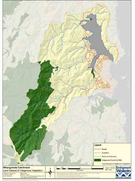
1   Introduction
    The Whangamata Harbour and its catchment (see map of Whangamata catchment in
    Appendix I) have many uses and contain many types of habitat for plants and animals.

    This natural environment provides attractive views as well as a place for recreation and
    food gathering. It is important that the harbour and its catchment can continue to
    provide for these multiple uses. Changing conditions within the harbour, impacts from
    the surrounding catchment and differing community opinions are placing pressure on
    the harbour and its habitats.

    Harbour management needs to balance people's uses and activities in the harbour and
    its catchment while recognising different opinions. Being able to easily access
    information on issues affecting the harbour and their relative importance is an important
    part in decision-making. This document brings this information together and presents a
    list of actions that agencies, groups and individuals could undertake to contribute to
    improving the health of the harbour and its catchment.

2   Integrated management for
    Whangamata Harbour
    The land and harbour are connected. To have a healthy harbour it is necessary to
    manage the harbour catchment and the harbour itself. For a healthy harbour it is
    important to look at what enters it from the land and sea. For example, run-off from
    surrounding land can contain sediment, bacteria and nutrients that can affect the health
    of the harbour. It is also important to consider the effects of invasive weeds and pests
    on marine and land habitats. This is why an ‘integrated management approach’ is
    required.

    Integrated management means environmental concerns must be balanced with social,
    cultural and economic impacts affecting the catchment. This approach also recognises
    the importance of actively working with communities to identify and carry out solutions
    that ensure the aspirations of individual groups are accommodated as far as possible.

    Identifying risks to the harbour, their severity of impact and the actions needed to
    eliminate or minimise the risks are an important part of integrated harbour
    management. For example, erosion in the catchment carries mud into the harbour,
    smothering shellfish beds, changing stream and harbour channels and altering
    habitats. One of the symptoms of increased mud is increased mangroves. These
    changes in the harbour are best managed by reducing erosion on the land, particularly
    where this is caused by people’s activities (for example, through urban development
    and agricultural/forestry use). The methods of reducing erosion often involve fencing to
    exclude stock from stream banks, planting trees to hold the soil and managing the
    pests that damage vegetation. As a result, less mud, nutrients and bacteria enter the
    harbour, while habitat along the streams is also improved. Therefore an integrated
    approach can have many benefits.

    Doc # 1037721                      DRAFT DOCUMENT                                  Page 1
A harbour plan involves looking at the harbour and its catchment. Better ways of
    managing the land are an important part of a harbour management plan.

2.1 Visions and goals for Whangamata's harbour and
    catchment
    Over the years, community processes and community groups have helped people
    identify what they want for the harbour, both in broad terms and in detail (goals for
    achievement). Below is a summary from the various publications.

    Specific visions and goals from existing documents

    These are some of the visions for the harbour from the Whangamata Community
    Plan, Hauraki Iwi Environmental Plan and Whangamata Harbour Care Aspiration Plan.

    x   Maintain open water usage within the main body of Whangamata harbour.
    x   The harbour will have a stable, natural backdrop including forests, bush walks, and
        appropriate land use.
    x   The harbour will be a clean, ecologically healthy, sandy playground in which human
        activity is in balance with nature.
    x   Productive pipi and cockle beds.
    x   To ensure public access will be provided around the harbour margins.
    x   Catchment management will minimise any adverse environmental effects.
    x   Greater understanding of coastal values by communities.
    x   No longer any contaminants polluting the waterways or harbour; and many more
        wetlands exist because of community activities.

    Here are some of the relevant goals for water from the Whangamata Community Plan
    and Hauraki Iwi Environmental Plan.

    x   To minimise the load to the wastewater system and ensure no pollutants enter the
        waters of Whangamata.
    x   To minimise the volume of run-off and pollutants entering the stormwater system.
    x   To ensure discharges to the waters of Whangamata will be managed to protect the
        wairua (spirit) of the estuaries and restore the health of the ecosystems.

    Here are some of the relevant goals for the harbour from the Whangamata
    Community Plan and Hauraki Iwi Environmental Plan.

    Page 2                              DRAFT DOCUMENT                           Doc # 1037721
x   To protect a range of diverse, healthy life in the harbour including birds, fish,
    shellfish and plants and ensure people will be able to harvest kaimoana (food from
    the sea) with confidence from productive and accessible beds.
x   To protect and restore estuarine habitats and ecosystems.
x   To plan how mangroves will be protected in identified areas, but kept out of areas
    where other ecosystem values and uses would be adversely affected by their
    presence.
x   To develop a community education programme to foster awareness of our coastal
    environments and their values.

Here are some of the relevant goals for the catchment from the Whangamata
Community Plan and Hauraki Iwi Environmental Plan.

x   Riparian planting and sediment trapping strategies for improving harbour water
    clarity and the sandiness of intertidal sea beds.
x   To ensure native vegetation will be cared for and will extend to cover the western
    face of the Peninsula.
x   To protect the riparian area of the catchment from harmful effects.
x   To ensure land use in the catchment will minimise erosion.
x   To reintroduce birds into restored forest and wetland habitats.
x   To increase inanga (whitebait) numbers and their spawning habitat.

A collective vision for the harbour

The visions and goals could be summarised as…

Agencies, community and Mãori working together on actions and physical works that
identify, enhance and restore cultural, recreational, ecological and visual values of the
harbour.

Doc # 1037721                         DRAFT DOCUMENT                                 Page 3
2.2 Significance of Whangamata Harbour to Hauraki
    iwi
    This statement of significance has been prepared by representatives of Hauraki iwi:

    The Whangamata Harbour is of cultural, spiritual and historical significance to Hauraki
    iwi. The harbour provides social, cultural, environmental and economic opportunities for
    its use and development.

    The philosophy of Hauraki iwi is to allow the present generation to use and develop the
    resources in a sustainable manner and to ensure that the resource is left in a better
    condition when it is handed to the next generation. What becomes important for
    Hauraki iwi is the balancing of Màori and community needs so that needs are not
    driven solely by economic development.

    Listed below are Hauraki iwi's goals for the Hauraki environment.

        x   To ensure that we sustain and enhance the mauri of the environment as kaitiaki.
        x   That protecting our past including cultural heritage sites, waahi tapu, places,
            landscapes and associated knowledge is a priority for Hauraki kaitiaki.
        x   To maintain and enhance our kaitiaki roles.
        x   To make informed decisions about the Whangamata Harbour, its surrounding
            environment and heritage.
        x   To ensure that central and local government, industry and local communities are
            upholding their Treaty of Waitangi obligations and that these are reflected in the
            decisions that are made.
        x   To ensure that communities understand and value Hauraki iwi involvement in
            environmental management and heritage protection.2

    In order for Hauraki iwi to ensure that these goals are achieved, particularly in relation
    to the Whangamata Harbour and its surrounding environs, then the following values will
    guide that process.

        x   Rangatiratanga - to exercise the right to make decisions over management,
            development, use and protection over taonga.
        x   Kaitiakitanga - to fulfil our ancestral obligations as kaitiaki.
        x   Wairuatanga - to spiritually respect taonga in recognition of the spiritual connection
            that exists between us and the natural world.
        x   Manaakitanga - to exercise our rights and responsibilities in a way that is beneficial
            to taonga.
        x   Whanaungatanga - to exercise our rights and responsibilities to taonga that
            acknowledges the whakapapa to each other and the natural world.
        x   Kotahitanga - to all work together and strive towards collective goals whilst
            recognizing the autonomy and needs of each participant.3

    As kaitiaki, we will continue to move towards the collective vision, goals and values of
    Hauraki iwi for the better use, development, enhancement and protection of the
    Hauraki tribal region for current and future generations.

    We will also work alongside of other community groups of like mindedness, local and
    central government to work actively towards the preservation, protection and
    enhancement of “nga taonga tuku iho” (those precious treasures that are passed down
    from generation to generation).

    2
        Hauraki Iwi Environmental Plan, produced by Hauraki Màori Trust Board, March 2004, p. 12
    3
        Hauraki Iwi Environmental Plan, produced by Hauraki Màori Trust Board, March 2004, p. 12

    Page 4                                          DRAFT DOCUMENT                                 Doc # 1037721
2.3 Management initiatives relating to the
Whangamata Harbour and catchment
Date Plans and Content Organisation
projects
1999 The future of the Results of community Environment Waikato.
Whangamata consultation.
Catchment and
harbour: what's
important to the
people?
2001 Whangamata Outlines for the Community Environment Waikato
Community Plan – Board and councils the and Thames-Coromandel
our future. direction for Whangamata District Council.
supported by the participants
at community forums.
2002 The Hauraki Gulf To integrate the management Central government and
Marine Park Act. of the Gulf. Hauraki Gulf Forum.
2002 – Nov Aspiration Plan A draft document showing Whangamata Harbour
Whangamata suggested zones for use in Care Inc.
Harbour. the harbour and their
management.
2004 - March Whaia te Mahere A vision and strategic plan to Hauraki MƗori Trust
Taiao a Hauraki. sustain the mauri of the Board.
Hauraki Iwi natural environment and
Environmental Plan. improvement in abundance
and quality of natural
resources.
2005 - Working together in Investigation into the Parliamentary
October Thames- Whangamata Community Commissioner for the
Coromandel: Plan giving weight to the Environment.
guidelines for need for integrated planning
community planning. and action.
2005 Regional Coastal Statutory policy document Environment Waikato.
Plan. used for managing the
coastal and marine areas.
Date Plans and Content Organisation
projects
2003 Peninsula Project. Erosion and flooding control Environment Waikato,
including pest management. DOC.
2004 Coastal Harbour Developing integrated planning Environment Waikato,
Plans. maps for future development Thames-Coromandel
directions in harbours and their District Council, DOC,
catchments. iwi.
2004 Whangamata Sites and areas of importance Environment Waikato
Heritage mapping. to tangata whenua and
Hauraki Màori Trust
Board.
2005 Coromandel Planning for the future growth Thames-Coromandel
Peninsula Blueprint of communities and zoning of District Council,
Project/Coromandel land and sea. Environment Waikato,
Growth Strategy. DOC, iwi.
2005 Long-Term Council Public input to council plans Environment Waikato.
Community Plan that help guide and direct work Thames-Coromandel
(LTCCP). programmes. District Council.
2005 Landscape survey. Survey of important Thames-Coromandel
landscapes on the District Council.
Coromandel.
Doc # 1037721 DRAFT DOCUMENT Page 53 Issues and action
3.1 Layout of the issues and action section
Various goals for the harbour have been outlined in community documents and issues
have been raised in community forums (for example, The Future of the Whangamata
Catchment and Harbour - Results of a Community Consultation, Labour Weekend,
October 1999). These are covered in the following section which is structured as
follows.
Issues
These are the issues raised in previous reports or at community meetings. They have
been arranged in order of subject.
x Water quality.
x Habitat.
x Sedimentation and flooding.
x Recreation, boating, access and views.
Some of the concerns raised relate to actual problems which need to be dealt with;
others reflect situations where people believe there is a problem but this may not
necessarily be the case. They also relate to community visions and goals developed
through the harbour plan process and in previous consultations, as outlined in sections
2.1, 2.2 and 2.3 above. Where required, the harbour plan proposes a number of
actions to be taken and also notes where past actions have occurred.
Evaluation
The available information and data provided has been used to assess the extent and
environmental importance of the issues. This section uses references to published
reports and summarises the results.
What is happening
This is a review of the relevant actions that agencies are currently undertaking.
What needs to be done
This section covers gaps or further actions that need to occur to address an issue.
3.2 Water quality
3.2.1 Issues
x Bacteria and nutrients, including:
- contaminants from the wastewater treatment area affecting water quality
- high amounts of bacteria in the water and in shellfish
- contaminants in stormwater entering the harbour
- increased nutrients in the water affecting the harbour.
x Accidental spills of oil or contaminants.
x Foams and scum floating on the water.
x The need for catchment based planning to protect water quality.
Sediment run-off from agricultural activities such as forestry and farming can also
impact on water quality, increasing silt levels in waterways, introducing nutrients and
bacteria and reducing water clarity where sediments are stirred up. For more
information on sediment in water, see section 3.4.
Page 6 DRAFT DOCUMENT Doc # 10377213.2.2 Evaluation
x Bacteria and nutrients
At the time of its construction the Whangamata wastewater treatment plant won awards
for its design. However, there has been significant growth in Whangamata since then.
In particular there is a hugely variable population that has to be dealt with by the plant
during the holiday summer period (for example, the population grew from 4,000 to
48,000 during the summer period in 2005). A summary of the history and issues of the
Whangamata wastewater treatment plant was completed by Thames-Coromandel
District Council in 2005.4 That report covers the issues and monitoring results relevant
to the plant and its associated irrigation areas and receiving streams. Future
improvement options were also covered.
The main points are listed below.
x The consent stipulates maximum summer and winter irrigation rates of 35
millimetres per week and 20 millimetres per week respectively. Compliance with
these consent conditions was poor during July and August 2004 with irrigation
exceeding 20 millimetres per week during each week. Only two other non-
compliances occurred during the 2004/05 period.
x The second other non-compliance was an irrigation rate of 77 millimetres per week
following a period of very heavy rain. This indicates the available storage in the
retention pond is insufficient to provide the required buffering of storm flows during
serious wet weather events.
x Nitrate concentrations downstream of the irrigation field are significantly higher than
those upstream, with the increase more pronounced during summer months.
x Infiltration of water into the sewer system during high rainfall events is currently a
significant issue for the Whangamata reticulation leading to overfilling of the effluent
retention pond.
Environment Waikato completed an audit report on the wastewater treatment plant in
2005.5 The results showed that:
x on occasions the plant was adding bacteria to the stream
x on occasions upstream sources of bacteria could also be high
x increases in bacteria levels below the plant indicate the likely source to be overland
flow from the irrigation area
x the treatment plant is adding considerable amounts of nitrate to the stream.
The table below shows results of monthly sampling of the Waikiekie stream above
(upper) and below (lower) the treatment plant for April 2004 to March 2005.
4
Thames-Coromandel District Council. 2005: Eastern Seaboard Wastewater Treatment Plant Projects - Whangamata
Status Report. 2005. Thames-Coromandel District Council, Thames.
5
Audit Report on Whangamata Sewage Scheme, Waikiekie Road. Environment Waikato doc #1023335.
Doc # 1037721 DRAFT DOCUMENT Page 7Monthly
Flow rate Faecal Coliform pH Nitrate-N Nitrate-N in kg per day
Date l/s MPN/100
Waikiekie Waikiekie Waikiekie Waikiekie
Upper Lower Upper Lower Upper Lower Upper Lower Upper Lower Difference
14-Apr-04 0.014 0.108 140 340 7.09 7.3 0.1 0.7 0.12 6.53 6.41
11-May-04 0.135 0.15 670 1600 7.39 7.33 0.3 1 3.50 12.96 9.46
15-Jun-04 0.098 0.136 46 62 7.59 7.29 0.2 1.7 1.69 19.98 18.28
12-Jul-04 0.187 0.258 180 270 7 7.05 0.285 1.21 4.60 26.97 22.37
13-Aug-04 0.085 0.22 160 145 7.28 7.24 0.272 1.42 2.00 26.99 24.99
09-Sep-04 0.335 0.509 10 145 6.87 6.98 0.122 0.802 3.53 35.27 31.74
11-Oct-04 0.188 0.288 184 248 6.98 7 0.31 0.87 5.04 21.65 16.61
12-Nov-04 0.08 0.182 1070 7500 7.17 7.21 0.14 0.52 0.97 8.18 7.21
09-Dec-04 0.19 0.132 240 430 7.31 7.26 0.13 1.21 2.13 13.80 11.67
10-Jan-05 0.145 0.102 320 670 7.6 7.57 0.077 2 0.96 17.63 16.66
11-Feb-05 0.072 0.142 2200 730 7.49 7.36 0.09 2.3 0.56 28.22 27.66
10-Mar-05 0.105 0.137 155 1030 7.77 7.68 0.036 1.6 0.33 18.94 18.61
Average kg of Nitrate-N lost per day 2.12 19.76 17.64
Tons of Nirate-N lost to the stream per year 6.44
Tons of nitrogen discharged to the disposal area per year 18.88
Environment Waikato investigated contaminant loads from water entering the harbour
from June 1999 to February 20006 and from January to March 2001.7
The 1999-2000 results showed that:
x bathing beaches in the harbour had low bacteria levels and were safe for swimming
x most of the contaminants entered the harbour from the land
x contaminant levels were at times high in the Moanaanuanu Estuary and near the
mouth of the Waikiekie Stream
x contaminants found in the Moanaanuanu Estuary appeared to have come from the
largely pastoral area catchment upstream of the Whangamata Golf Course
x there was no evidence of any substantial leak of contaminants from the
Whangamata wastewater treatment pond but there was leakage from the spray
irrigation area
x leakage from the effluent spray irrigation area was contributing a major load of
nitrogen to the stream (and thus to the harbour).
The summary below is from the 1999-2000 report.
The bathing beaches were found to be suitable for swimming. In particular,
the median level of enterococci at the harbour bathing beach site was 90% of saturation), and levels of nutrients and faecal bacteria were
generally low. However, none of the surveys were undertaken during periods
of high freshwater flow, and it is likely that levels of some contaminants may
increase during and after flood events. Furthermore, although water quality
was generally good over large areas of the harbour, it was found to be poorer
in areas where moderately-contaminated river or stream water mixed with
harbour water. As a result, contaminant levels were moderately-high at times
in the Moanaanuanu Estuary, and near the mouth of the Waikiekie Stream.
6
Vant, B. 2000: Whangamata Harbour water quality investigations, 1999-2000. Environment Waikato technical report
2000/02. Environment Waikato, Hamilton.
7
Environment Waikato. 2001: Whangamata Harbour; Contaminant loads and water quality, 2001. Environment
Waikato Technical Report 2001/04, Environment Waikato, Hamilton.
Page 8 DRAFT DOCUMENT Doc # 1037721In these areas, contaminant levels were generally highest when salinities were
low, and vice versa. Most of the contaminants therefore entered the harbour
from the land, rather than from the sea (although there may have been an
exception to this at the time of the [very windy] December survey). The
contaminants found in the Moanaanuanu Estuary appeared to have entered
the Wentworth River from the catchment upstream of the Whangamata golf
course. There was no evidence of any substantial leak of contaminants from
the Whangamata wastewater treatment pond (which is located adjacent to a
small stream which enters the Moanaanuanu Estuary downstream of the golf
course).
Longitudinal surveys of the Wentworth River suggested that most of the
contaminant load at the golf course entered the river from the largely pastoral
area in the lower part of the catchment. Inspection of this area showed that
livestock had unrestricted access to the river at places, and that contaminated
runoff from the adjacent land was likely to enter the river. The moderate
degree of contamination observed in the stream was broadly consistent with
this type of land use.
Comparison of the levels of faecal bacteria in the Waikiekie Stream with those
found in other small streams in the Waikato Region suggests that the bacterial
load is partly due to the small amount of pastoral farming in the catchment,
and partly to leakage from the spray irrigation area. The overall loads of
faecal bacteria to the harbour from the Wentworth River and the Waikiekie
Stream appear to be of similar magnitude.
Levels of nitrogen in the lower Waikiekie Stream were 30–100 times higher
than in the Wentworth River. Together with the conclusions of a previous
assessment, this fact suggests that leakage from the spray irrigation area is
contributing a major load of nitrogen to the stream (and thus to the harbour).
This load may have increased over the past decade. The potential for the
nitrogen load to support nuisance plant growth in the harbour should be
thoroughly assessed.
The 2001 results showed that:
x run-off water from storm events resulted in significantly increasing the bacteria
levels in the harbour
x the amount of nitrogen and phosphorous entering the harbour was also greatly
increased by storm events
x at other times bacteria levels in the harbour were within bathing water guidelines
x the majority of the nitrogen entering the harbour was from the Waikiekie Stream
x the effluent spray irrigation area was a source of contaminants
x high amounts of bacteria and phosphorus were coming from stormwater outlets
during light rain
x feral animals in forested areas were contributing to bacteria levels in forested
streams
x the pastoral area of the Wentworth River contributed most of the turbidity observed
at the lower end of the river and at times contributed much of the loads of the other
contaminants.
Doc # 1037721 DRAFT DOCUMENT Page 9The summary below is from the 2001 report.
Four surveys of the loads of contaminants in the catchment of Whangamata
Harbour were made during January-to-March 2001. Loads were calculated
from measurements of stream flow and contaminant concentrations at sites on
six streams and two stormwater outfalls flowing into the harbour. Loads were
also measured at 11 sites in the catchment of the Wentworth River, the single
largest inflow to the harbour. The water quality in two sub-estuaries of the
harbour, which previous work had shown to be moderately contaminated, was
determined. Samples were also collected from the coastal water flowing into
and out of the harbour.
Contaminant loads in dry weather were found to be much lower than in wet
weather. During the highest flow event surveyed - estimated to be a flow that
is exceeded about 10% of the time—the total load of faecal coliform bacteria
to the harbour was about 60 times higher than that measured during dry
weather. The load of enterococci was about 30 times greater, while those of
total phosphorus and total nitrogen were about 80 and 40 times higher,
respectively. The high flow event appeared to flush-out the catchment to
some extent, as specific yields of bacteria were much lower in a moderately-
high flow survey a fortnight later.
The Wentworth sub-catchment contributed 40–60% of the total flow, and a
similar proportion of many of the contaminants. The next largest sub-
catchment, the Otuwheti, was also an important source of contaminants at
times. The smaller Waikiekie sub-catchment contributed a disproportionate
share of both the total nitrogen (30–70%) and the nitrate nitrogen (66–92%)
entering the harbour. It was also an important source of faecal bacteria at
times (up to 27%). In this case, most of the nitrate and perhaps half of the
faecal bacteria probably enters the stream in surface and sub-surface runoff
from the Whangamata wastewater spray-irrigation area.
Under conditions of light rain, the two surveyed stormwater outfalls contributed
disproportionately high loads of contaminants. The combined loads of faecal
bacteria were equal to about 20% of the total load from the streams, while the
loads of turbidity and total phosphorus were equal to 25–40% of the stream
loads.
In the Wentworth sub-catchment the area of native bush upstream of the
upper-most sampling site contributed about half of the flow in the river.
However, it generally contributed considerably smaller proportions of the
faecal bacteria and total nitrogen, and only 10–14% of the turbidity. The rest
of the loads came from the largely-pastoral area downstream of this site. Two
permanent drains through areas of farmland contributed relatively high loads
of nutrients and faecal bacteria.
Field measurements in the two estuaries showed that the less dense river
water tended to flow downstream above a layer of more dense seawater. At
the more landward sites, concentrations of faecal bacteria and nitrogen were
usually higher—occasionally much higher—in the less saline near-surface
layer. At the seaward sites, however, the contaminants were generally more
evenly-distributed. There was no evidence of any substantial input of
contaminants into the Moanaanuanu estuary in the vicinity of the Whangamata
wastewater treatment pond.
On each survey, the quality of the coastal waters entering and leaving the
harbour on the inflowing and outgoing tides tended to be similar. Relatively-
high concentrations of faecal bacteria were measured in these waters during
the high freshwater flow event. On this occasion most of the bacterial load
Page 10 DRAFT DOCUMENT Doc # 1037721came from the Wentworth (28–39%), Otuwheti (20–35%) and Waikiekie (4–
27%) sub-catchments. Flushing of the catchment over the following fortnight,
however, meant that contaminant loads at the end of the fortnight were much
lower. As a result, bacterial concentrations in the harbour and coastal waters
were also lower on the two surveys following the high flow event. While
individual heavy rain events can reduce the suitability of the harbour and
nearby coastal waters for bathing, an extended period of moderate-to-high
flows appears to offset this to some extent by flushing contaminants from the
catchment.
Water and shellfish were tested for faecal coliforms in December 1998 and compared
to safety thresholds because the Boardriders’ Association had concerns about the
water quality near the harbour bar (11 September to 13 October 1988). Overall, some
beaches and rivers were safe to swim in but others weren’t. Shellfish gathered from
some locations were safe to eat but not from other locations. It was not safe to eat
shellfish gathered from the boat ramp, particularly mussels. Only the bacteria levels
were determined, not the source.
The results of a 1999-2000 survey8 also concluded that shellfish gathered from the
southern half of the harbour should probably not be eaten.
Note: There is some evidence that mangroves can assist in maintaining water quality –
for more information see ‘Mangrove history, distribution and ecological function’ in
section 3.3.2.
x Accidental spills of oil or contaminants
Environment Waikato operates a 24 hour ready response and marine oil spills service
for dealing with spills and other pollution incidents that can't be dealt with routinely by
staff during working hours. For most incidents (except those which are very minor)
Environment Waikato staff will typically get to the site as soon as possible to assess
the risks to the environment and to liaise and provide advice to the relevant
agencies/people (for example, district council, fire service, contractors, site owner,
potentially affected parties etc.). Environment Waikato staff liaise with the relevant
parties to assist and make sure containment, clean up and notification processes
happen. This liaison also helps Environment Waikato to find out the reasons and
possible liability for the spill so potential enforcement or future preventative actions can
be taken. Environment Waikato has experienced staff on hand in Whangamata,
Whitianga and Paeroa. They have specific training in spill management as well as
knowledge and contacts regarding appropriate spill containment equipment.
x Foams and scum floating on the water
The 1999-2000 survey9 reported on foams and scums in the harbour. The main
findings are listed below.
x Foams contained carbohydrates and bacteria levels were higher in the foam than in
the water.
x Higher levels of bacteria were expected because bacteria in surface films can be
many times higher than those in the underlying water.
x Foams occur in other harbours and are natural.
x There was no evidence that foams in Moanaanuanu Estuary are associated with
sewage.
“These various observations suggest that the foams and scums observed in and near
the Moanaanuanu Estuary, while being visually conspicuous - and having the potential
to be aesthetically unpleasant, are likely to have been natural phenomena. There was
8
Vant, B. 2000: Whangamata Harbour water quality investigations, 1999-2000. Environment Waikato technical report
2000/02. Environment Waikato, Hamilton.
9
As in footnote (11) above.
Doc # 1037721 DRAFT DOCUMENT Page 11no evidence from these observations that the features were directly associated with
sewage.” 10
The extract below is from that report.11
On 12 December a reconnaissance was made of the Moanaanuanu estuarine
mixing zone between the causeway and the golf course. Conspicuous surface
features were observed at two locations near the time of high water (colour
photographs were taken of these, and copies are available on request). The
first was a patch of yellow-brown foam, about 2 m u 1 m in size which was
observed in shallow water (c. 0.2 m deep) near the edge of the channel in an
area of salt-marsh vegetation (map reference T12, 646 389). It appeared to
be typical of the type of foam which is often observed in such areas. I
consider it was likely to have been a naturally-occurring estuarine foam,
resulting from wind and wave action on polysaccharide surfactants which had
been released by coastal plants (e.g. microalgae).
An example of scum that occurs from time to time in Whangamata Harbour.
Surface foams have also been observed on other Coromandel estuaries. A
visual and microbiological assessment of foam collected from Tairua Harbour
showed a high level of marine material including living and dead pennate
diatom skeletons, aggregates of organic matter and inorganic particles.
Bacteria were numerous and active. It was concluded that the foam “was most
likely derived from a natural bloom of photosynthetic algae … probably
pennate diatoms”. It was observed that “these organisms coat their silica cell
in mucilage and excrete further mucilage as a slime layer on which they
move”, and that the mucilage “may give rise to a stable foam when suspended
from tidal flats on the incoming tide and worked by the wind”. It was further
concluded that “the foam itself is not indicative of, or resulting from, waste
containing high levels of faecal bacteria”.
These various observations suggest that the foams and scums observed in
and near the Moanaanuanu Estuary, while being visually conspicuous—and
having the potential to be aesthetically unpleasant, are likely to have been
natural phenomena12. There was no evidence from these observations that
the features were directly associated with sewage.
x The need for catchment based planning to protect water quality
10
Vant, B. 2000: Whangamata Harbour water quality investigations, 1999-2000. Environment Waikato technical report
2000/02. Environment Waikato, Hamilton.
11
As in footnote (13) above.
12
Note that while the processes directly responsible for these phenomena may be described as “natural”, the rates at
which the processes occur may have increased as a result of catchment and urban development (for example,
higher nutrient levels supporting larger amounts and clumps of algae, increased bank erosion producing higher
loads of fine sediments).
Page 12 DRAFT DOCUMENT Doc # 1037721The need for catchment based planning is clearly recognised by Environment
Waikato’s Regional Policy Statement (RPS). This forms the basis for Environment
Waikato’s activities and those of the district council.
Below is a list of relevant statements from the RPS.
x Assess objectives and policies relating to land and water resources to encourage
the enhancement of the coastal environment and ensure that ‘up-stream’ activities
have minimal adverse effects on coastal areas.
x Through liaison with territorial authorities (TAs), iwi and other agencies, promote
the integrated management of land and water resources including the use of a
catchment based approach for the management of contaminants, especially those
from non-point sources.
x Through an environmental education programme developed in consultation with
other parties, advocate: the rehabilitation of degraded soils; sustainable land
management practices; riparian management for soil conservation purposes;
protection, enhancement or restoration of vegetation (particularly indigenous
vegetation) especially on land which has high erosion risk; and retirement of land
subject to severe accelerated erosion.
x Through liaison with TAs, iwi and other agencies, promote the integrated
management of land and water resources including the use of a catchment based
approach.
x Through liaison with organisations with resource management responsibilities in the
coastal environment, ensure integrated management of coastal resources.
x Through regional plans, district plans and resource consents identify and provide
for the protection of significant characteristics of outstanding water bodies.
x Through liaison with TAs and interested parties, ensure the integrated management
of land and water resources.
x Through regional plans, district plans, and resource consent applications, require
the assessment of effects of land use development and subdivision on the
significant characteristics of water quality.
x Through regional plans, district plans and resource consents ensure that
stormwater discharges are managed to achieve the objectives and policies of the
RPS.
For more information on proposed catchment works and services programmes, see
this plan’s supporting document, the Draft Whangamata Catchment Management Plan
2007.
3.2.3 What is happening
x Bacteria and nutrients
Contaminants from the wastewater treatment area affecting water quality
Significant community consultation was carried out in Whangamata to gain community
input, particularly into potential effluent disposal options. The Community Board also
initiated consultation in conjunction with Thames-Coromandel District Council on the
issue of development in Whangamata, particularly infill subdivision, given that it is one
source of additional load on the wastewater plant. For example, in 2005 all ratepayers
(approximately 4500) were mailed a questionnaire seeking their views on the infill
subdivision 'issue'. This is one area that the Community Board is keen to see
considered early in Thames-Coromandel District Council's review of its Proposed
District Plan and has an indirect link to Whangamata Harbour. The Whangamata
Wastewater Plant has now been granted consents for its upgrade. Water quality
standards were finalised as part of consents for the construction of the plant and
disposal methods for the treated effluent.13
13
The consented disposal method (after high level treatment within a new Sequential Batch Reactor based plant) is via
an expanded forest irrigation system.
Doc # 1037721 DRAFT DOCUMENT Page 13An upgrade of the wastewater plant should cut nitrogen losses by 60 per cent.
x The upgraded wastewater treatment plant is intended to provide treatment capacity
for population expansion over the coming 30 years.
x The upgraded treatment plant will focus on improving the microbial quality of the
discharge, and reducing nutrient concentrations in the treated effluent. Estimated
time of completion is mid-2008. The plant will have the capacity to cope with peak
population loads. The quality of the irrigated wastewater will be significantly better
in terms of nitrogen and bacteria loads.
High amounts of bacteria in the water and in shellfish
There appears to be very little proactive action to help reduce bacteria in run-off from
farmland or areas of native bush.
Contaminants in stormwater entering the harbour
Thames-Coromandel District Council has recently installed approximately 44
stormwater pit filters in the area from Hunt Road to the causeway and across to the
wharf. Where possible each pit had a filter fitted, as stormwater in this area drains
directly into to the harbour. A combination of the Ecosol and Enviropod products was
used – roughly half of each – in an effort to remove some of the larger pollutants such
as rubbish, cigarette butts etc.
The draft stormwater management plan for Whangamata is recommending a
swale/soakage14 approach to the treatment of stormwater rather than a
comprehensive reticulated system.
Increased nutrients in water affecting the harbour
There is some fencing and planting along the edges of streams and rivers and shores
('riparian' areas) to help keep nutrient out of waterways but more is needed. Farmers
applying annually over 60 kilograms of nitrogen per hectare are now required by
Environment Waikato to have a Nutrient Management Plan.
x Accidental spills of oil or contaminants
Spills that happen in freshwater are responded to by Environment Waikato’s ready
response and marine oil spills teams. Anyone noticing such a spill should immediately
notify Environment Waikato by calling Environment Waikato’s freephone 0800 800
401.
Coastal News 22 September 2005
14
A swale is a low-lying stretch of land which can be used to hold and/or filter water.
Page 14 DRAFT DOCUMENT Doc # 1037721x Foams or scums floating on the water
Foams and scums are natural occurrences and no action is required.
x The need for catchment-based planning to protect water quality
There are several projects underway that incorporate catchment based planning.
These include the Peninsula project, the Wentworth 'Clean Streams' project and
Whangamata's sewage plant upgrade. For more information, see the Draft
Whangamata Catchment Management Plan 2007.
3.2.4 What needs to be done
Bacteria and nutrients
x Options for removal of contaminants from stormwater are in place or being
investigated.
x Continue education to ensure people understand that chemicals and contaminants
should not be poured down stormwater drains or onto surfaces draining to
stormwater.
x Put in place processes to reduce high loads of contaminants coming from two
permanent drains entering the Wentworth River.
x Encourage more farmers to fence and plant the waterways on their properties and
install bridges and culverts for stock crossings
x Identify properties with high rates of nutrient leaching and run-off, and help the
owners put in places practices that will improve their nutrient efficiency and reduce
contaminant run-off.
x Carry out futher animal pest control in forested areas to reduce bacteria from feral
animals.
x Excess or unnecessary fertiliser use needs to be avoided.
Accidental spills of oil or contaminants
x Regularly inspect high risk industries.
x Continue spill prevention and containment training.
x Ensure equipment for spills is readily available.
x Boaties need to be aware of spill prevention procedures and the actions they
should take if a spill occurs.
The need for catchment-based planning to protect water quality
x Prioritise in regional and district planning documents the actions needed to improve
water quality.
3.3 Habitat
Estuaries in the Whangamata Harbour area support a wide variety of plant and animal
life, as illustrated in the two diagrams below.
This diagram shows the range of plant habitats the Waikato region's estuaries typically
feature at each tidal level.
Doc # 1037721 DRAFT DOCUMENT Page 15This diagram shows the variety of animals that can live in mud. (Graphic: NIWA)
However, land clearance for urban development, forestry and farming has changed the
natural character of the area significantly; and remaining native vegetation areas need
to be protected and increased wherever possible.
3.3.1 Issues
x Mangrove expansion displacing other habitats and open water.
x Unauthorised clearing of mangroves.
x Loss of wetlands by drainage and reclamation of the harbour edge.
x Harvesting pressures on shellfish.
x Invasive weeds and pests (land, freshwater and marine).
x Ecological corridors connecting the different ecosystems.
x Whitebait and eel numbers.
x Mangrove expansion displacing other habitats and open water.
x Unauthorised clearing of mangroves.
x Loss of wetlands by drainage and reclamation of the harbour edge.
Over time mangroves have spread throughout the harbour. Their expansion may be
associated with the displacement of other habitats, a reduction in recreational areas of
open water, increasingly restricted access to the coast, a decrease in the availability of
intertidal feeding areas to birds and fish and the loss of some open water views.
For a full discussion on the pros and cons of mangrove removal in the Whangamata
Harbour, see Environment Waikato’s Whangamata Mangrove Management Options
Report and Environment Waikato’s mangroves webpage. This information can be
found on our website at www.ew.govt.nz/projects/whangamata/index.htm.
Appendix II of the mangrove management options report also contains a copy of the
National Institute for Water and Atmospheric Research’s (NIWA) publication, ‘For and
Against Mangrove Control’’. Copies of this publication can also be found on NIWA’s
website at http://www.niwascience.co.nz/rc/freshwater/mangrove.pdf/view_pdf. This
publication clarifies the facts about mangroves, the consequences of actions taken in
relation to them and the likelihood of achieving goals through these actions.
Other councils are also dealing with the complex challenge of managing mangroves in
their area. For example, Auckland Regional Council (ARC) and Environment Bay of
Plenty (EBoP) conducted separate reviews of mangrove issues. EBoP’s review
focuses on mangroves management in their region, while ARC’s review focuses on a
technical review of the current state of knowledge of mangrove ecology, recent
Page 16 DRAFT DOCUMENT Doc # 1037721expansion, and its effects. This information is available in PDF format on each
council’s website or by phoning the council concerned to order a printed copy.
x Environment Bay of Plenty – Estuary Care Review (2007).15
x Auckland Regional Council – The New Zealand Mangrove: Review of the Current
State of Knowledge16 and its summary booklet, ‘New Zealand's Mangroves’
(2007).17
x Harvesting pressures on shellfish
The collection of shellfish by increasing numbers of people and people taking more
than the legal limit is an issue that needs to be monitored to ensure sustainable
harvesting of the shellfish in the harbour.
x Invasive weeds and pests (land, freshwater and marine)
Undaria
The kelp Undaria pinnatifida, a native of
the north-west Pacific, was introduced to
New Zealand during the 1980s. Undaria
(pictured right) was probably transported
to New Zealand in the holds of ships as
ballast water originating from Australia or
Japan. Although Undaria has potential as
a farmed sea vegetable, it is causing
concern in a number of highly valued
coastal areas in southern New Zealand.
This is because it is threatening native
algal biodiversity and ecosystem
structure and function in these areas. Undaria has been found in the Firth of Thames.
Saltwater Paspalum
Saltwater Paspalum (Paspalum vaginatum) is an invasive introduced saltmarsh grass
which occurs in many estuaries and along coastal foreshores of the northern half of the
North Island. It has been reported in a number of estuaries in the Waikato region,
including Manaia, Coromandel, Whangapoua, Whitianga, Tairua, Whangamata and
Otahu harbours.
An assessment of estuarine vegetation cover in Whangamata Harbour for the period
between 1997 and 200318 has shown that saltwater Paspalum has increased in extent
by approximately one hectare. Although this increase accounts for less than one per
cent of the total estuarine vegetation cover, the latest ground surveys (2007)19 show
that this species continues to expand rapidly in the harbour. It is likely that saltwater
Paspalum may have similar impacts to those documented for Spartina (another
saltmarsh grass causing problems in New Zealand), significantly threatening important
habitats around the edges of the harbour (Graeme and Kendal, in Turner and Riddle,
2001).20
15
Environment Bay of Plenty, 2007: Estuary Care Review. Report to Council, report no. 010607, May, Catalyst
Management Services. http://www.envbop.govt.nz/coast/media/pdf/Mangroves-Report-to-Council-010607.pdf.
16
Morrisey, D., Beard, C., Morrison, M., Craggs, R. and Lowe, M., 2007: The New Zealand Mangrove: Review of the
Current State of Knowledge. Auckland Regional Council Technical Publication Number 325, Auckland, New
Zealand. http://www.arc.govt.nz/arc/index.cfm?B1BFD2DD-BCD4-1A24-901C-9AD2050A42F2#mangrove.
Auckland Regional Council, 2007: Mangroves in New Zealand. Summary booklet. Auckland Regional Council,
Auckland, New Zealand. http://www.arc.govt.nz/arc/index.cfm?BB3A7F29-BCD4-1A24-9734-A117F8A54F0E.
17
Auckland Regional Council, 2007: Mangroves in New Zealand. Summary booklet. Auckland Regional Council,
Auckland, New Zealand. http://www.arc.govt.nz/arc/index.cfm?BB3A7F29-BCD4-1A24-9734-A117F8A54F0E.
18
Graeme, M. (1997): Estuary Vegetation Survey Pilot Study: Whangamata, Wharekawa and Otahu. Natural Solutions
Ltd: Marine and Terrestrial Ecologists Report. Environment Waikato.
19
Graeme, M. (2007): Estuarine Vegetation Survey: Whangamata Harbour and Otahu Estuary. Natural Solutions Ltd:
Marine and Terrestrial Ecologists Report No. 07/067. Environment Waikato.
20
Turner, S. and B. Riddle. 2001: Estuarine sedimentation and vegetation – management issues and monitoring
priorities. Environment Waikato Internal Series 2001/05. Environment Waikato, Hamilton.
Doc # 1037721 DRAFT DOCUMENT Page 17The 2007 survey showed that saltwater Paspalum in the Whangamata Harbour is
already out-competing natural sea-meadow communities and reducing the extent of
other native vegetation such as saltmarsh ribbonwood and rushes. It also grows in the
open estuary where it traps sediment. If saltwater Paspalum is allowed to continue
spreading, it will not only further threaten native vegetation, but also help increase the
rate of harbour infilling.
Sea squirt
A new invasive species of sea squirt (Styela clava) has been found in some parts of
New Zealand. This sea squirt (pictured below) prefers sheltered harbours and attaches
to hard structures below the low tide mark. More information can be found on the
Biosecurity New Zealand web site.21
Rats
It has been suggested that mangroves and the scrubby shoreline support large
numbers of rats. If so, this would affect birds' use of mangrove habitats. At certain
times of low tide and no moon, numerous rat tracks are observed on the mud flats.
Other animal pests
Animal pests such as possums are impacting on native plants and animals, and their
impact on vegetation is resulting in erosion and soil run-off in some areas of the
catchment (particularly in the forested areas of the upper catchment).
x Ecological corridors connecting the different ecosystems
The connection of different ecosystems is necessary for some species. Whitebait for
example need both harbour and stream habitat. They are dependent on grassed
stream edges for breeding and also need to be able to reach shady forested streams.
A continuous natural connection between the different habitats allows birds to easy
move from one habitat to another at different times of the year.
x Whitebait and eel numbers
Continued food gathering from the harbour and streams is important and an increase in
theses food sources is desirable.
21
www.biosecurity.govt.nz/seasquirt
Page 18 DRAFT DOCUMENT Doc # 10377213.3.2 Evaluation
x Mangrove expansion displacing other habitats and open water
x Unauthorised clearing of mangroves
x Loss of wetlands by drainage and reclamation of the harbour edge
Vegetation surveys for the harbour were done in 1995/96 and 2004. The methods for
assessing the area of the harbour may have differed and both give different areas for
the harbour. However, areas of vegetation should be comparable. A further vegetation
survey has been carried out by Environment Waikato in 2007.22
Areas of vegetation and habitat based on Environment Waikato’s 1995/96
survey20
Vegetation/habitat Hectares 1995/96 Per cent of
harbour
Seagrass 50.9 12.4
Mangrove 105.4 25.7
Saltmarsh 22.4 5.5
Invasive weedsHabitat
The Waikato Regional Coastal Plan recognises the upper Whangamata Harbour as an area
of significant conservation value.
Mr Roxburgh (DOC) stated in evidence for the Whangamata marina: “The harbour and
its environs were ranked as a site of “high” wildlife value (SSWI) by the Wildlife Service
in 1981. This is the second highest in a five tier system ranging from Outstanding to
Potential. The Coromandel Peninsula was surveyed as part of a “national survey” of
wildlife habitats completed by the Fauna Survey Unit of the Wildlife Service. The
expressed intention of the survey was to rank habitats according to their value in
supporting and maintaining local, regional and national populations of endemic,
indigenous and introduced wildlife…These rankings are due to the presence of the
following threatened species; Caspian tern Hydroprogne caspia, banded rail Rallus
philippensis assimilis, Australasian bittern Botaurus stellaris poicilloptilus, the NZ
dotterel Charadrius obscurus, and the variable oystercatcher Haemotopus unicolor. A
number of international migratory waders also frequent the harbour, the most common
of these is the bar tailed godwit Limosa lapponica baueri.”25
Mr Roxburgh also stated that Whangamata is a “significant” site for the dotterel on the
south eastern Coromandel Peninsula due to the presence of up to 16 flocking birds
(recorded in 1994). He suggested that it “may well be” the second most preferred site.
In the past three years there has been a noticeable increase in both nesting and
flocking birds in Whangamata. About 60 birds were flocking in 2007. Whangamata
remains an important area for the dotterel. Dotterel in the past nested in the harbour
but lately this has not occurred and may be related to disturbance. The Otahu estuary
remains their preferred nesting site. Oystercatchers however continue to nest in the
harbour.26
Direct human disturbance poses the most immediate and direct threat to the remaining
saltmarsh areas.27 Saltmarsh is particularly vulnerable to people walking or driving
across it, particularly with heavy machinery. Human disturbance also affects habitat
use by birds, fish and invertebrates. Fire is also a very obvious threat.
Rare skink discovered
An investigation initiated by Environment Waikato following unauthorised mangrove
clearance and burning of saltmarsh areas discovered that an apparently healthy
population of Moko Skink (Oligosoma moco) is present on the causeway.27 Numerous
individuals were sighted sun-basking along the causeway banks immediately above the
cleared mangrove area. This species (pictured below) is confined to northern New
Zealand and has mostly been recorded from offshore islands, with only a few known
mainland populations in Northland, Auckland and the Bay of Plenty. This population
had not previously been recorded (Leigh Marshall, personal comment) and must be
regarded as highly significant.
25
Review of evidence regarding ecological values – proposed Whangamata Marina site. Environment Waikato doc.
#977026.
26
Graeme Webb; personal comment.
27
Whangamata Mangrove Clearance & Saltmarsh Damage, November 2005; letter to Environment Waikato by Kessels
& Associates Ltd.
Page 20 DRAFT DOCUMENT Doc # 1037721You can also read