DRR-Team Mission Report - Fiji - Western Division, Ba & Rakiraki - DSS water
←
→
Page content transcription
If your browser does not render page correctly, please read the page content below
DRR-Team Mission Report
Fiji - Western Division, Ba & Rakiraki

     DRR Mission Report Fiji: Scoping Mission for Flood Alleviation Measures for Ba & Rakiraki Towns
     (and associated water catchments)                                                              i
August 2019
DRR Mission Report Fiji: Scoping Mission for Flood Alleviation Measures for Ba & Rakiraki Towns (and
associated water catchments)

 Document title                            DRR Mission Report Fiji: Scoping Mission for Flood Alleviation
                                           Measures for Ba & Rakiraki Towns (and associated water
                                           catchments)
 Status                                    final 2.0
 Date                                      8 October 2019
 Project name                              Ba & Rakiraki Flood Alleviation Project
 Reference                                 116224/19-016.139

 Drafted by                                Victor Coenen, Koen Overkamp, Irene Pohl, Fred de Bruijn
 Checked by                                Fred de Bruijn / Amit Singh / RVO
 Date/initials check
 Approved by                               RVO
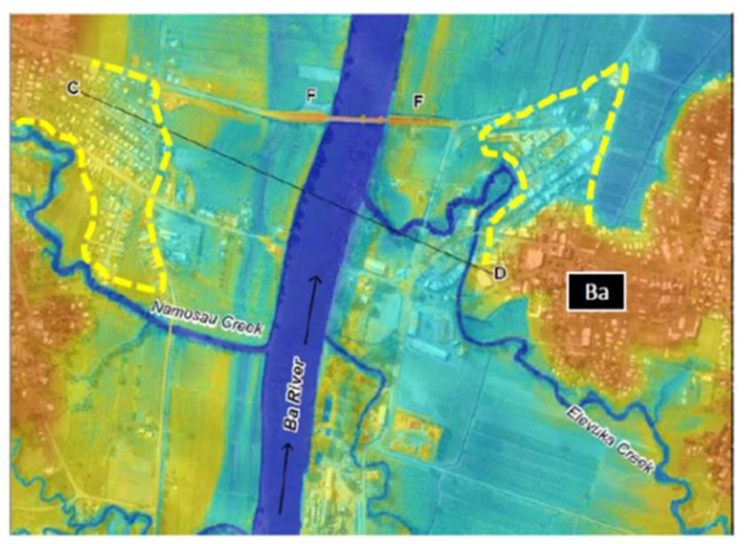
TABLE OF CONTENTS

1     INTRODUCTION-THE DRR MISSION TO FIJI                           1

2     BACKGROUND                                                     3

2.1   Ba and Rakiraki                                                3

2.2   Effect of climate change on Fiji                               3

2.3   Ba Town and the Ba River system                                4

      2.3.1    Geography in Ba                                       4
      2.3.2    Rainfall and rainfall distribution in Ba              6
      2.3.3    Hydrology in Ba                                       6
      2.3.4    Field visit and observations in Ba River system       8

2.4   Rakiraki and the Penang River System                          11

      2.4.1    Area description Penang catchment                    11
      2.4.2    Field visit and observations in Rakiraki             12

2.5   The institutional context of MOWE                             13

3     CONSIDERED INTERVENTIONS (BA)                                 14

3.1   Improving local preparedness                                  14

3.2   Ecosystem based interventions                                 16

3.3   ‘Hard’ engineering interventions                              16

3.4   ‘Soft’ engineering interventions                              19

4     CONSIDERED INTERVENTIONS (RAKIRAKI)                           23

5     CONCLUSIONS AND RECOMMENDATIONS                               24

5.1   An integrated flood mitigation strategy for Ba and Rakiraki   24

5.2   The integrated strategy Ba Town                               25

5.3   Integrated strategy Penang River and Rakiraki Town            27

5.4   Economic Viability                                            27

5.5   Environmental and Social Sustainability                       28

5.6   Way forward                                                   29
      5.6.1    Long-Term Perspective (30 years from now)            29
      5.6.2    Mid-Term Perspective (10-15 years from now)          29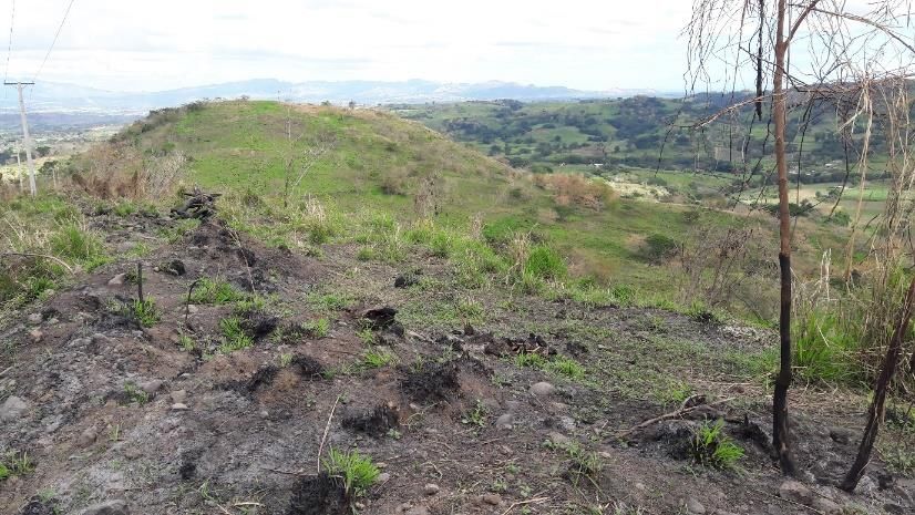
5.6.3    Short-Term Perspective (within 10 years)                              30

5.7   Foreseen projects and potential funding options                                30

      Last page                                                                      31

      APPENDICES                                                              Number of
                                                                                 pages
I     DRR mission, activities and contacts

II    Bibliography

III   Terms of reference of the Fiji DRR Team

IV    Follow up potential (preliminary Terms of reference for follow up TA)

V     Project sheets (indicative description of optional projects)

VI    List of relevant funding agencies

VII   Dutch contact details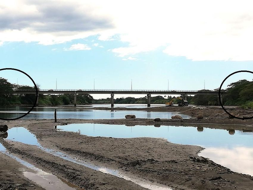
Abbreviations

 MOWE           Ministry of Waterways and Environment
 DRR Team       Dutch Risk Reduction Team
 ToR            Terms of Reference
 UN             United Nations
 SIDS           Small Island Development States
 FJ$            Fiji dollar (= 0.45 US$)
 JICA           Japan International Cooperation Agency
 WB             World Bank
 ADB            Asian Development Bank
 EU             European Union
 GEF            Global Environmental Facility
 GIZ            Deutsche Gesellschaft für Internationale Zusammenarbeit (German
                Development Agency)
 GCF            Green Climate Fund
 RVO            Netherlands Enterprise Agency
 LWRM           Land and Water Resources Management
 DEM            Digital Elevation Model
 IUCN           International Union for Conservation of Nature
 WWF            World Wildlife Fund
 ESIA           Environmental and Social Impact Assessment
 DRM            Disaster Risk Management
 NDMO           National Disaster Management Office
 DFCD           Dutch Fund for Climate and Development
 UNICEF         United Nations Children’s Fund
 UNDP           United Nations Development Program
 FAO            Food and Agricultural Organization of the UN
 SPC            Scientific Pacific Community
 FRA            Fiji Road Authority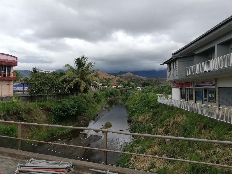
Executive Summary

Context
Upon request of the Fiji Ministry of Waterways and Environment (MOWE), a Dutch Disaster Risk Reduction
team visited Fiji from 17 until 28 August 2019 and conducted an assessment of the floods in the Ba and
Penang catchments, to gain insight in causes and mechanisms and identify potential flood mitigation
options. In Fiji, floods continue to cause tremendous damage to communities. Human lives and livelihoods
are regularly lost and there are substantial damages to infrastructure and crops. Some parts of Fiji are
extremely vulnerable to flooding even without cyclonic activity. For example, in January 2012 serious
flooding caused FJ$36.4 M (= US$16.5 M) and FJ$12.2 M (=US$ 5.5 M) in household damages for the Ba
River and Penang River (Rakiraki) catchments, respectively. Two months later the March 2012 flood caused
FJ$24.1 M (=US$11 M) and FJ$8.4 M (=US$ 3.8M) in damages to both catchments, respectively. Since then
there have been numerous flood events with the most recent events occurring in April 2018 and February
2019. Urban growth, poor spatial planning, unfavourable land use and climate change, leading to more
frequent high intensity rainfall and sea level rise, will increase flood risks facing the two catchments of Ba and
Rakiraki. It is of national priority that an assessment be undertaken to address factors that cause floods in
these catchments and map interventions to address these factors.

Findings
The DRR mission has conducted extensive field visits, and met with many relevant stakeholders.
Findings of the field observations Ba can be summarized as follows:
- large parts of Ba Town have been developed in flood prone areas (the lower part of the flood plain);

-   floods must be expected to be part of Ba’s reality. This means that the early warning system under
    preparation by the Meteorology Service Fiji (Canadian funded) is important to Ba;

-   the elevated approaches to the 1998 constructed Kingsroad bridge have an obstructing impact in major
    flood conditions (when the floodplain becomes vital in discharging flood water)

-   it is clear that a comprehensive catchment approach is required, where the land use and conduct needs
    to be changed by stimulating reforestation and changing agricultural practices;

-   the Ba system is a clear example where Ridge is connected to the Reefs and everything in between. Ba
    Town is severely affected by sedimentation, and mangrove system and outer reefs have been susceptible
    to long term change effects. As the system is also victim to Climate Change effects, the Ba system may
    be a good example for a Green Climate based approach;

-   the rainfall distribution during rainstorm events seems to vary per event, making it difficult to identify the
    right locations for upstream interventions;

-   flood waters (flood levels, velocity) have a major impact on Ba Town, but also erosion and sedimentation
    is a serious issue as this aggravates the impact of floods both directly (damage to buildings) and
    indirectly (reducing the discharge capacity of Ba River).

For Rakiraki similar findings can be reported, whereas the flood hazards for Rakiraki have been effectively
reduced by a successful dredging intervention in 2017 (see our report), while further improvements have
been proposed.

Institutional framework
Concerning the institutional landscape, it is widely acknowledged that water governance in Fiji is too
fragmented, with too many government bodies are at stake. The Ministry of Waterways and Environment
was established in 2017 in recognition of this situation, but the ‘work is not finished’: the mandate of MOWE
requires improved legal basis, in particular there is a need to review the Land and Water Resources Bill
(2016) which currently falls under the responsibility of the Minister of Agriculture. Moreover, if MOWE takes
on more responsibilities, it comes along with an increased need for work capacity, expertise, and (financial)
resources. During the mission MOWE mentioned several times that the ministry is understaffed and that they
face many difficulties to find qualified people.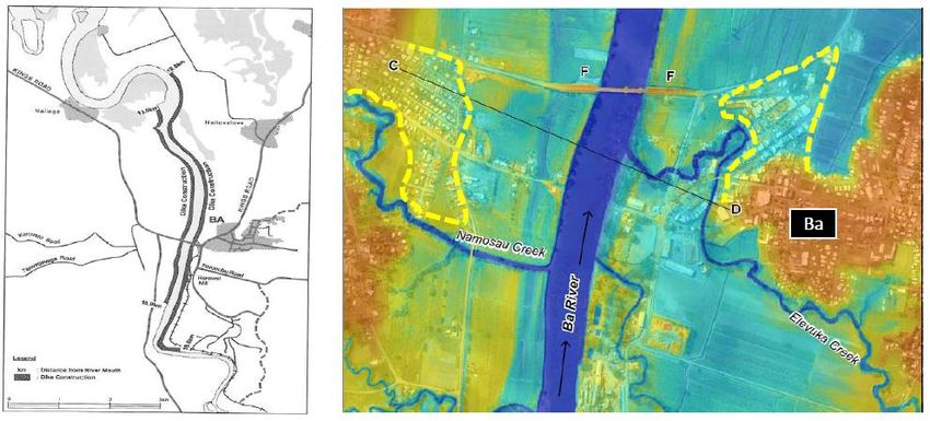
Interventions
In close consultation with MOWE, the following mix of interventions is proposed for Ba:
- Improve preparedness of the population, where the ‘early warning system’ currently under preparation
    will be an important aspect. (short-mid-long)

-   Give priority and allocate additional funds for reforestation, riparian restoration and (changed)
    agriculture practice to the Ba catchment. This involves a ‘multi-sector-approach’ and would be well
    aligned to Green Climate agenda aspects. MOWE is recommended to co-ordinate a multi-sectoral
    initiative to open dialogue with Fiji’s development partners. (long-term effect, short-term need!)

-   Complement a comprehensive, environmental sustainable, catchment approach with short-term
    engineering interventions, including these three elements:

    ·   Dredging upstream of Kings Road Bridge (combined with continued downstream dredging), taking
        the structural integrity of the bridge into consideration, (short-mid-term)

    ·   Opening the elevated ramps of Kings Road Bridge by culverts, or, preferably, long piled ramps,
        (short-mid-term)

    ·   Lowering of the floodplain on west and east river bank next to Ba Town. (short-mid-term)

    These intervention (separate and/or combined) will substantially increase the discharge capacity of Ba
    River near Ba Town.

-   Hydrodynamic modelling of these interventions (individually and as integrated intervention) is required
    to assess the best cost-effective intervention mix. This can be completed within a few months’ time (a
    DEM already exists, providing a detailed topographical basis); (short-trerm)

-   Conduct preliminary Environmental and Social Impact Analysis of interventions. There will be an
    inevitable impact on land-use, some residents and business, as well as influence on downstream
    ecosystem. (short-term)

-   Constructing dikes close to Ba Town (with gates at the Elevuka Creek) could be explored as a fall-back
    option when the soft-engineering interventions prove to be insufficient. (mid-term)

-   Flow-through dams and multi-purpose dams might contribute to flood mitigation and combatting
    droughts, but there are some constraints which need to be further evaluated in a technical and
    environmental feasibility study. Advocacy and research for (smaller) retention basins in the middle and
    upper catchment is recommended. (mid-term)

The strategy for Rakiraki, compares to the Ba strategy in aiming for a comprehensive catchment approach
and is proposed to also include:

    ·   Regular maintenance dredging of the Creek through Rakiraki Town; (short-term)
    ·   Feasibility study, design and construction of a ‘sediment trap’ upstream of Rakiraki Town. (short-mid-
        term)

Way forward
In this report both long-term as well as short and mid-term interventions have been identified. In its request,
MOWE has specifically asked for concrete, short-term options. In the appendices several project options
have been elaborated in project fact sheets. In the way forward, the DRR mission identifies an important
dilemma: it is recognized by all stakeholders that a real change in governance, land use and catchment
management is required in order to attain sustainable long-term resilience. Fiji and its development partners
need to carefully combine the short to mid-term engineering interventions, with true commitment to long-
term changes in governance and land use. For Rakiraki and Ba the next step will need to be to enter in a
‘project definition stage’ where project interventions are technically explored and budget estimates are
prepared. For Ba River this needs to be combined with a hydraulic model of the river system to assess and
compare the various technical interventions. MOWE and the DRR team have held preparatory talks with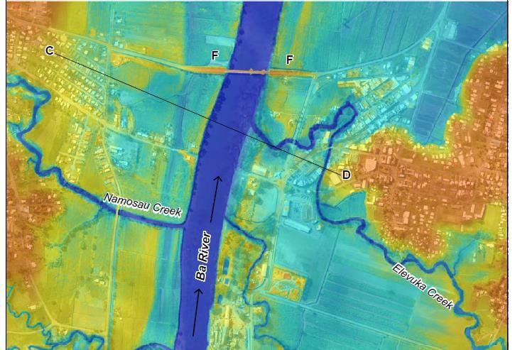
several development partners, and a preliminary ToR for project definition is included in the appendices of
this report. Our team proposes that the preparation for short-mid-term interventions is set up in
combination with (aligned) initiatives for an integrated long-term programme. Moreover, these long-term
initiatives are recommended to be connected to currently ongoing (demo/pilot) initiatives, for instance on
Ridge-to-Reef (UNDP): every project/intervention needs to contribute to true, long-term changes.
The current flood hazards to, especially, Ba are both real and severe. In the scoping mission it has been
assessed that there are feasible and tangible project options that would alleviate the situation, and which are
expected to be economically viable in the Ba context.
1           INTRODUCTION-THE DRR MISSION TO FIJI

The World Bank estimated in 2012 that natural disasters cause average annual direct losses of US$284
million in the Pacific. With a combined population of fewer than 10 million people, annual losses are the
highest in the world on a per-capita basis. As such, the UN World Conference on Disaster Reduction
acknowledged that small island states such as those in the Pacific require concerted attention due to their
high levels of exposure to hydrometeorological hazards such as hurricanes, cyclones, and tropical
depressions (Hay, 2009; PCRAFI, 2011). The UN Secretary-General Antonio Guterres reaffirmed the call for
concerted attention for the Pacific when he visited the region in May 2019.

In Fiji, floods continue to cause tremendous damage to communities. Human lives and livelihoods are
regularly lost and there are substantial damages to infrastructure and crops. Some parts of Fiji are extremely
vulnerable to flooding even without cyclonic activity. For example, a persistent monsoon triggered record
rainfall over five days in January 2009 (FMS, 2009). Severe flooding of the Nadi, Ba, and Sigagtoka rivers
followed (Ambroz, 2009), with floodwaters rising to an estimated 2.5-3m at the Rarawai mill near the Ba
Township. Eleven lives were lost during the floods and 11,458 people were forced to seek shelter in
evacuation centres (Ambroz, 2009; McGree et al., 2010). Public utilities were disrupted for more than a
fortnight, and the government declared a 30-day state of natural disaster. In the immediate aftermath, the
total costs were estimated at FJ$113 million by the Fiji government (Ambroz, 2009). This figure was later
revised up to FJ$175 million (Mcgree et al., 2010).

In January 2012, again serious flooding caused FJ$36.4 M (= US$16.5 M) and FJ$12.2 M (=US$ 5.5 M) in
damages for the Ba River and Penang River (Rakiraki) catchments, respectively. Two months later the March
2012 flood caused FJ$24.1 M (=US$11 M) and FJ$8.4 M (=US$ 3.8M) in damages to both catchments,
respectively. Since then there have been numerous flood events with the most recent events occurring in
April 2018 and February 2019. Urban growth, poor spatial planning, unfavourable land use and climate
change, leading to more frequent high intensity rainfall and sea level rise, will increase flood risks facing the
two catchments of Ba and Rakiraki. It is of national priority that an assessment be undertaken to address
factors that cause floods in these catchments and map interventions to address these factors.

Figure 1: 2018 flood in Ba

Upon request of the Fiji Ministry of Waterways and Environment (MOWE), a Dutch Disaster Risk Reduction
team visited Fiji from 17 until 28 August 2019 and conducted an assessment of the floods in the Ba and
Penang catchments, to gain insight in causes and mechanisms and identify potential flood mitigation
options. While keeping the Dutch Multi-Layer Safety approach1 in mind, the team looked at a number of
mitigation and adaptation interventions which can be categorized as follows:
- improving local preparedness against floods such as early warning systems and adaptation of buildings.
    Prevention measures need to include sustainable spatial planning and effective disaster management;
- ecosystem based solutions such as reforestation, mangrove protection and riparian restoration;
- ‘hard’ engineering solutions such as dikes/levees and dams;

1
    https://www.researchgate.net/publication/283121531_A_multi-layer_flood_safety_approach_towards_resilient_cities

1 | 31      DRR Mission Report Fiji: Scoping Mission for Flood Alleviation Measures for Ba & Rakiraki Towns (and associated water catchments)
- ‘soft’ engineering solutions such as river widening, flood plain lowering.
In addition to doing technical assessments in both catchment areas, MOWE requested the team also to look
at institutional and legislation aspects in relation to flood risk management as well as exploring funding
options for potential follow up activities. Th terms of reference of the DRR Team mission to Fiji is provided in
appendix III.
While there was quite a lot of information available for the catchment area of Ba, this was not the case for
Penang catchment (Rakiraki). As Ba faces also the largest flood risk challenges, the DRR Team mission mainly
concentrated on the situation in the Ba catchment. This explains the fact that the analysis on Rakiraki
catchment is less substantial in this report.
This technical report details the findings of this mission and the recommendations to the counterpart
organization, The Fiji Ministry of Waterways and Environment.
Multi-layer Safety approach
While doing the assessments in the Ba and Rakiraki catchment the Fiji DRR Team looked at the catchment
from a multi-layer safety angle. Hereunder the multi-layer approach is explained in a nutshell and the
principles have been translated to the Ba and Rakiraki context.
The main idea behind the multi-layer safety approach is that besides taking preventive measures, (e.g. dike
enforcement), it is also important to minimize the consequences of floods.
Within this concept there are three distinct layers:
- Prevention. By this we mean the primary dike and river system.
The safety level of this system is determined on the basis of a
cost/benefit analysis and a victim analysis based on the chance of
flooding.
- Sustainable spatial planning. This refers to spatial partitioning, for
example compartmentalisation by means of secondary dikes or
other structures. Efforts are underway to find opportunities to use
spatial measures to address multiple purposes, such as nature
conservation, recreation and infrastructure. In this second level of
water safety, zoning is based on flood risk. Second layer measures
are already common in rural areas of the Netherlands, and these
have recently been redeveloped for urban areas, such as in the
concept of the “Self-reliant Island of Dordrecht”.
- Disaster management. This involves realising better co-ordination
between the various emergency service providers, administrative decision-making, communication modes
and evacuation plans. Water-robust construction and infrastructure, as well as the development of
emergency refuges, are other measures that belong to this third layer.
Whereas in the past all attention was given to the first layer of prevention in the form of dikes, nowadays
efforts are being made to also investigate the potentials of spatial planning and disaster management.
The introduction of the second and third layers means that current measures are now tailored to local areas in
order to help minimise flood damage. In the Netherlands there are clear requirements for the dimensioning of
the first layer, i.e., the dikes. Measures undertaken in layers two and three have no influence on the required
degree of safety provided by layer one.
Disclaimer
Most of the hydrological numbers presented in this report have been derived from the JICA study (1998).
Considering the modelling limitations in 1998 when topography and vegetation in the wider floodplain
could not be properly modelled, the accuracy of the data may not be optimal. These limitations were taken
into account while preparing this report and defining concepts.
Reading guide
Section 2 provides a background and context to the Mission and the catchments/towns. Sections 3 and 4
elaborate on strategies/interventions for Ba and Rakiraki respectively. In section 5 Conclusions and
Recommendations are included.
2 | 31 DRR Mission Report Fiji: Scoping Mission for Flood Alleviation Measures for Ba & Rakiraki Towns (and associated water catchments)2 BACKGROUND
2.1 Ba and Rakiraki
The two catchment areas that have been studied by the DRR Team are Ba River and Penang River. Both
located on the North-western side of the main island Viti Levu. The main city in the Ba catchment is Ba Town
and in the Penang catchment is this Rakiraki town. Both towns/catchments are circled in the map figure 3.
Fiji is a group of volcanic islands in the
South Pacific, lying about 4,450 kilometres
southwest of Honolulu and 1,770 km north
of New Zealand. Of the 332 islands and
522 smaller islets making up
the archipelago, about 106 are
permanently inhabited. The total land size
is 18,272 km2. Viti Levu, the largest island,
covers about 57% of the nation's land area,
hosts the two official cities,
the capital Suva, and Lautoka and also
Nadi (the site of the international airport),
and contains some 69% of the
population. Vanua Levu, 64 km (40 mi) to
the north of Viti Levu, covers just over 30% Figure 2: Location of Fiji in the pacific
of the land area though is home to only some
15% of the population. Both islands are mountainous, with peaks up to 1,300 m (4,300 ft) rising abruptly from
the shore, and covered with tropical forests. Heavy rains (up to 304 cm or 120 inches annually) fall on the
windward (south-eastern) side, covering these sections of the islands with dense tropical forest. Lowlands on the
western portions of each of the main islands are sheltered by the mountains and have a well-marked dry
season favourable to crops such as sugarcane1.
Figure.3: Map of Fiji and the location of the Ba and Rakiraki catchment
2.2 Effect of climate change on Fiji
While debates on climate change and its impact continue, there is reason to fear that rainfall-induced flood
conditions for Fiji will deteriorate in the coming decades. In addition, long periods of absence of rainfall
causing drought are expected to occur more frequently.
1
https://en.wikipedia.org/wiki/Geography_of_Fiji
3 | 31 DRR Mission Report Fiji: Scoping Mission for Flood Alleviation Measures for Ba & Rakiraki Towns (and associated water catchments)While patterns in natural hazards related to climate change are observable on a global basis, changes in climate on a regional scale depend highly on atmospheric patterns and oceanic circulation (Bates et al., 2008), making it difficult to isolate trends in natural hazard frequency over the historical record. Nevertheless, Australian Bureau of Meteorology and CSIRO (2011) observe that temperatures in the South Pacific have increased by 0.6°C in the last hundred years, and ADB (2011) finds that events such as storm surges, floods, and droughts have increased in the Pacific in recent decades. Figure 3 plots flood height against time for Fiji’s Ba River, demonstrating a strong increasing trend (Yeo et al., 2007; Yeo, pers. comm, 22 July 2013). Thus, climactic trends in the Pacific appear to follow those observed more widely. To anticipate future trends, PICCAP (2005) developed risk projections for Fiji using two General Circulation Models (GCMs) within the Special Report on Emissions Scenarios. While the A2 scenario is considered to be extreme, the B2 scenario is considered to be ‘mid-range’. Under this mid-range scenario, PICCAP projects that: • average temperature will increase by 0.5°C by 2025, by 0.9°C by 2050, and by 1.6°C by 2100; • annual rainfall will increase by 3.3% by 2025, by 5.7% by 2050, and by 9.7% by 2100; • sea level will rise by 11cm by 2025, by 23cm by 2050, and by 50cm by 2100; and • maximum wind gusts will increase by 3.4% by 2025, by 6.8% by 2050, and by 13.4% by 2100. Taken together, these projections indicate that climate change will lead to higher incidence of natural disasters, including flooding, landslides, and coastal erosion. It is also expected that agricultural productivity will decline (Preston et al., 2006), with stronger winds expected to damage crops including sugar, banana, and coconuts and flooding expected to damage root crops such as taro and cassava. Figure 4: Flood height of the Ba River over time, with trend line 2.3 Ba Town and the Ba River system 2.3.1 Geography in Ba The Ba River drains an area of 937 km2 and originates at the Tavua caldera at a distance of 89 km from the sea. The Ba River is fed by a series of tributaries originating in deeply dissected upstream valleys with elevations up to 1100 metres. The upper reaches are mostly steep (slopes 1 in 20) while the slope near the sea is gentle (1 in 300, JICA). The upper reach of the catchment is mostly deforested and used for either grazing or farming. 4 | 31 DRR Mission Report Fiji: Scoping Mission for Flood Alleviation Measures for Ba & Rakiraki Towns (and associated water catchments)
Figure 5: The upper reaches of the Ba Catchment with deforested uplands

Ba municipality is located in the flood plain of the Ba River, less than 10 kms from the sea and consists of two
urban centres: Ba Town (east river bank) and Yalalevu (west river bank). These urban centres are connected
by the Kings Road Bridge which was constructed in 1998 after the old bridge was washed away by a flood.
One of the tributaries of the Ba River, Elevuka Creek, runs through Ba Town.

A literature study preceded this mission. Much of the data and early insights were derived from the following
studies:
- JICA 1998: the Study on Watershed Management and Flood Control for the four major Viti Levu Rivers in
     the Republic of Fiji Islands

-   The work of Dr Stephen Yeo, notably:
         . Ba Community Flood Preparedness Project-Final Report (2000)
         . Refining the Historical Flood Series for Ba, Fiji (2015)

Next to these key documents, also several other research documents, policy papers and articles on flood
resilience, nature-based solutions and climate adaptation in Fiji were studied (a full list can be found in
appendix II to this report).
The JICA study contains a wealth of data on discharge volumes, design levels and other hydraulic aspects as
well as options for interventions. However, one must be aware of the era in which this report was prepared. In
1998, the mainstream thinking in flood management focused largely on ‘hard’ interventions, like dikes, dams
and other civil engineering works. ‘Soft’ interventions like floodplain lowering and diversion of water were often
not considered nor regarded as proven technology. Only after computing power developed and digital
modelling became widely deployed (at the beginning of this century), soft interventions could be designed
properly. Only then these interventions became an integral part of the flood managers toolbox. But this was
after the JICA report was released.
Stephen Yeo studied the Ba floods over an extended period of time. His research focuses on flood levels in Ba
Town and flood frequencies. However, the studied work of Dr Yeo does not contain all hydrologic relevant
information like a flood hydrograph and Q-h relationships.
Nevertheless, the JICA report and the documents of Dr Yeo and other authors provided a good starting point
and reference material from which the DRR Team could work. The data presented in this report stem from
these two sources.

5 | 31   DRR Mission Report Fiji: Scoping Mission for Flood Alleviation Measures for Ba & Rakiraki Towns (and associated water catchments)
2.3.2 Rainfall and rainfall distribution in Ba
There are distinct seasons in the Ba catchment. The annual rainfall is 2000-2500 mm/year, but most of the
rainfall is in the rainy (cyclone) season (November until March) where average monthly rainfall is between
300-400 mm, with peaks of up to 1000 mm/month when cyclones or tropical depressions hit the island of
Viti Levu. The peak of the dry season is June/July with only 20-50 mm rainfall.
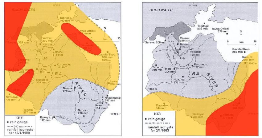
The rainfall distribution in the Ba catchment during extreme events is an important aspect to evaluate,
especially for interventions that focus on the upstream area. Is there a specific
area where heavy rainfall is concentrated in rainstorm events or is the rainfall
evenly distributed over the whole catchment? This matters if one wants to plan
(high investment) engineering works.
In his 2000 report, Dr Yeo shows two rainfall Isohyets related to the 1993 and
1999 floods. Both floods are similar in flood levels (7,11 m and 7,34 at
Rarawai), but they originate from different rainfall distributions:
- the 1993 flood originates in heavy rainfall over a wide area in the South-
East upper reaches (300-400 mm in Koro, Nanoko)
- the 1999 flood originates in heavy rainfall in the central part of the Ba
catchment (Navala, 300 mm) and very heavy rainfall (> 400 mm) in two
small areas: the North-East and South West
Figure 6: Map of Ba River catchment (Yeo, 2007)
Figure 7: Areas with very heavy rainfall (>400 mm, red) and heavy rainfall (> 300 mm. yellow) during the floods of 1999 (left) and
1993 (right). Source: Yeo, 2000
2.3.3 Hydrology in Ba
There is not so much hydraulic information available because discharges, levels and velocities in the Ba River
are not monitored regularly: the river gauge was destroyed several times and records are patchy (Yeo, 2015).
This technical report will therefore use numbers from the JICA report (see table below) and the 2015 study
by Dr Yeo.
The JICA (1998) report is still the main resource document for flood discharges in Ba. Table 1 (below) shows
the discharge and return period.
6 | 31 DRR Mission Report Fiji: Scoping Mission for Flood Alleviation Measures for Ba & Rakiraki Towns (and associated water catchments)Table 1: Flood discharge by return period (JICA, 1998) In his 2015 report (p.17, footnote), Dr Yeo mentions the he has seen only one Q-h calculation for Ba River: January 1993. The discharge was determined to be 4638 m3/s at a flood level of 6,515 m (above mean sea level?). This flood level corresponds with a flood of 1,5-2 metres water depth in Ba Town. These numbers, like the calculated JICA discharges, should be regarded as being an indication rather than being accurate. According to the JICA table, the 1993 flood would have been a 1/30 event. However, the 1993 flood levels were matched in 1997 and exceeded in 1999, 2009 and even twice in 2012. This series of frequently occurred floods suggests that the 1993 flood would be a more frequent event (more consistent with a 1/10 or 1/5 frequency). It should be noted that the river discharge is also strongly influenced by the tidal regime at the intertidal section of the river close to Ba Town. Often with heavy rainfall also strong winds (cyclones, depressions) are encountered, pushing up sea water into the Ba River. Land use in the Ba catchment Ba catchment land use consists of the cultivation of market garden produce for home use and local market purposes, and comprises vegetables and cassava planted primarily on the river flats and on the vacant spaces near and surrounding the sugar cane fields. Yaqona and Dalo is cultivated on the forested slopes and in the upper catchment of the Ba River. Additional cash crops such as tomatoes, cabbage, beans and tobacco are planted on flats near riverbanks and sugar cane fields, and in locations that provide easy transport to the produce market. Bananas are another commodity that grows well in the Ba Catchment as it has the advantage of being easy to look after and sells for a good return in the market. There exists some level of cattle farming within the upper Catchment of the Ba River and sugar cane farmers also graze their animals within the sugar cane blocks. Overall, the main land use currently in the Ba Catchment is sugar cane cultivation, prevalent in all areas within the Catchment, including those Villages accessible by all-weather roads. (Land Use Report Ba Catchment 2011). Figure 9: Sugar cane fields in middle section of Ba River Figure 8: Sugar cane Rarawai mill in Ba Population and households in Ba According to Fiji Bureau of Statistic, the population of Ba Province is 247.685 (2017 census), out of which approximately 40.000 – 45.000 people live in Ba Tikina (district), which is most comparable to Ba catchment, the study area. According to the 2007 census, ca. two thirds of the population are Indo-Fijian, one third is iTaukei (2007 census). The total number of households in urban areas in Ba district is 3,782 out of which 2214 in Ba peri-urban ward. 889 households are classified as being informal housing, representing 24% of the 7 | 31 DRR Mission Report Fiji: Scoping Mission for Flood Alleviation Measures for Ba & Rakiraki Towns (and associated water catchments)
households in urban areas. The structures of informal housings are of lesser quality than formal housing,
implying a higher vulnerability of this group of inhabitants to flooding and other natural disasters. The majority
of the population is in the 5-9 year group; more than 25% of the population is below 15 years old.
According to a 2008 study, 34% of Ba live below the poverty rate (Narsey, 2008), potentially indicating a high
vulnerability of almost one third of the population.

Employment and economy in Ba
Ba district registers 688 businesses (out of which 194 run by unpaid family workers, and 572 with a paid
proprietor), representing 6% of Fiji’s businesses. Putting this number in perspective: while Ba district is home to
1,8% of Fiji’s population, its share of Fiji businesses is three times as high.
In the urban areas of Ba district, ca. 6% of the labour force is unemployed, and the great majority (85,9%)
works in paid employment. Average male salary is 8970 FJD annually, female salary FJD 6424 annually
(average numbers of the Western Division according to the 2017 census). From a survey on average household
income in 2014, it was reported that household income Ba catchment is FJD 7849.
The most important commercial activities outside town in the catchment area are sugar production, timber
harvesting, and fishing.
Source: Fiji Bureau of Statistic

2.3.4    Field visit and observations in Ba River system
The Team visited the Ba catchment for 2 days. Besides studying some areas in the catchment, the team also
spoke with a number of representatives from the Ba Town Council, the Ba chamber of commerce and with
other local stakeholders from Ba Town and surrounding villages. The team started in the upper Ba catchment
and followed the river downstream to Ba Town. The following observations were made:

Erosion and sedimentation
Large parts of Fiji have been deforested over the last century on an industrial scale. The upper reaches of the
Ba catchment are now mostly without forests and covered in grasslands. In the middle range sugar cane
fields and subsistence agriculture is present. Burning of grasslands is used to prepare lands for sowing and
planting and sugar cane fields are burned prior to harvesting (to ease the harvesting of canes). Most farmers
are old and the younger generation is not interested in agriculture and is moving to the cities. This leads to
‘absentee ownership’ and neglect of rural areas. The combination of deforestation, agriculture on slopes,
burning of fields and general neglect has a devastating impact on run-off and erosion and sedimentation.
Floods and large-scale downstream
sedimentation are the result.

When visiting the area, most soils were
covered with vegetation and some
burning of grasslands and sugarcane
fields was observed. This burning does
not only expose soils to rains, but also
affects the soil structure (by loss of
organic matter and damaging grass
roots), making it very susceptible for
erosion.
                                                       Figure 10: burned land and exposed soil in the upper reach of Ba catchment

8 | 31   DRR Mission Report Fiji: Scoping Mission for Flood Alleviation Measures for Ba & Rakiraki Towns (and associated water catchments)
Evidence of large-scale sedimentation can be found throughout the catchment: riverbanks consist of deep alluvial deposits and sediment loads in rivers are high, more than 60 million tons per year according to MOWE. JICA (1998) calculated annual erosion levels in the upper reaches to be around 5.5 mm per ha. These huge amounts of sediments cause many problems when agriculture fields and Ba Town are flooded. While the water recedes rather quickly after a flood, a thick layer of mud remains behind in Figure 11: Ba River near Toge (middle section). The riverbanks consist of 4-5 metre high alluvial deposits the fields, streets and houses. It takes a lot of effort and money to clean it up. Moreover, the heavy sediment loads also have a detrimental effect on the coral reefs located in the vicinity of the river mouth. Riparian vegetation When visiting the Ba River catchment, the team also observed that in some sections, the riverbanks are unstable, damaged and prone to erosion. There is a regulation in Fiji saying that farmers and other users are not allowed to cultivate or build in the riparian zone of 30 metres from the riverbank (Land Conservation and Improvement Act 1985 now LWRM Bill 2016). However, this rule is often not enforced and that is why in many parts along the river illegal activities are taking place in the riparian zone, sometimes resulting in unstable river embankments. Ba Town and Elevuka Creek While the office of Ba Town council is safely built on higher ground in Ba Town, it is observed that most of the commercial areas are located in the low-lying parts of Ba Town, which are prone to flood risks. A large farmers market and also a large supermarket are built almost adjacent to the Elevuka Creek and the Ba River. Poor spatial planning and not enforcing building codes makes Ba Town very vulnerable for floods. Elevuka Creek streams right through Ba Town before it discharges into Ba River. The creek is considered to be one of the weak points in the hydraulic system in and around Ba. It easily floods in a situation with high rainfall and/or high water levels in the Ba River: at times the Creek triggers a flood from upstream heavy rainfall. At other times Ba River rises and pushes the Creek back into town. As the Creek meanders through the urban area, space is very much constrained for any intervention (like embankments). 9 | 31 DRR Mission Report Fiji: Scoping Mission for Flood Alleviation Measures for Ba & Rakiraki Towns (and associated water catchments)
Figure 13: Elevuka Creek in Ba Town                                      Figure 12: Low lying commercial street in Ba Town

The Kings Road Bridge
When discussing the flood
events in Ba Town with local
stakeholders, it was often
mentioned that Ba Town
suffers from more flooding
since the construction of
the Kings Road Bridge in
1998. The previous bridge
was located upstream of Ba
and was washed away in
1993. However, the Kings
Road Bridge has been built
just downstream of Ba and
has long ramps (approx.
200m) on both sides of the
river (see circles). According
to the locals these ramps
cause serious obstruction of
the floodplain when the Ba
                                 Figure 14: Kings Road Bridge and the circled ramps causing obstruction in the flood plain
River discharges high
volumes of water. Furthermore, one can observe the high sediment loads in the river. In the dry period, when
it is low tide excavators enter the river and remove silt from the riverbed.

Conclusions of the field observations Ba
- large parts of Ba Town have been developed in flood prone areas (the lower part of the flood plain)
- floods must be expected to be part of Ba’s reality. This means that the early warning system under
   preparation by the Meteorology Service Fiji (Canadian funded) is important to Ba;
- the elevated approaches to the bridge have an obstructing impact in major flood conditions (when the
   floodplain becomes vital in discharging flood water)
- it is clear that a catchment approach is required, where the land use and conduct needs to be changed
   by stimulating reforestation and changing agricultural practices;
- the Ba system is a clear example where Ridge is connected to the Reefs and everything in between. Ba
   Town is severely affected by sedimentation, and mangrove system and outer reefs nave been susceptible
   to long term change effects. As the system is also victim to Climate Change effects, the Ba system may
   be a good example for a Green Climate based approach;
- care should be taken when using the discharge and return periods mentioned in the JICA report. They
   should be validated with more contemporary tools before applying them in design and engineering
   projects
- the rainfall distribution during rainstorm events seems to vary per event, making it difficult to identify the
   right locations for upstream interventions

10 | 31   DRR Mission Report Fiji: Scoping Mission for Flood Alleviation Measures for Ba & Rakiraki Towns (and associated water catchments)
- flood waters (flood levels, velocity) have a major impact on Ba Town, but also erosion and sedimentation
is a serious issue as this aggravates the impact of floods both directly (damage to buildings) and
indirectly (reducing the discharge capacity of Ba River).
2.4 Rakiraki and the Penang River System
2.4.1 Area description Penang catchment
Many of the background descriptions for Ba apply to Rakiraki as well. Especially with regard to erosion in the
upper catchment and along the riverbanks. The Penang River (creek) however is substantially smaller and
shorter than the Ba River (data on discharge volumes are absent). The river originates from undulating
uplands, continues through a valley with extensive sugar cane plantations and runs through Rakiraki town
centre before continuing through cane plantations and entering a major river.
The Penang River catchment is about 10,250 ha in size. Land use is dominated by talasiga (open grassland),
which comprises about 45% of the total area, and sugarcane/ agriculture (43%). Other land uses include
forests (10%), and developments (2%). An overview of land use in the catchment is displayed in Figure 11.
(Brown et al, 2014)
The Penang River
(alternatively, the Rakiraki
River) is known to have
flooded in 1914, 1939, 1956,
1972, 1986, 1999, 2004,
2009, 2012, and 2014.
Although the Penang River is
considerably smaller than the
Ba River, significant flooding
and forced evacuations in
recent years have prompted
the Rakiraki provincial
administrator to call for
proposals to divert the river
and/or to relocate Rakiraki
Town (Fiji Ministry of
Information, 2012).
Figure 15: Land use Penang catchment (Brown P. et al, 2014)
Population and households in Rakiraki
According to Fiji Bureau of Statistic, the population of Ra Province is 30.416 (2017 census), out of which 13.908
live in Rakiraki Tikina (district), accounting for 0,7% of Fiji’s overall population. The total number of households
in Ra urban areas is 1396, out of which ca. 30% live in Rakiraki town, the rest in Rakiraki peri-urban area. 319
households are classified as being informal housing, representing 23% of the households in urban areas. Based
on visual observations, informal housings have a more vulnerable structure than proper houses, implying that a
large number of households in the area is living in housing conditions that are physically highly vulnerable to
floods.
The majority of the population is in the 0-4 year group; ca. 28% of the population is below 15 years old (2017
census).
According to the analysis of the RESCCUE program1, the education and literacy level is high, with 87% of the
population having received some level of formal education.
Employment and economy in Rakiraki
Rakiraki district registers 275 businesses, out of which 30 are run by unpaid family workers, 232 by paid
proprietors. These 275 businesses represent 2,2% of Fiji’s overall businesses. In the urban areas of Rakiraki
district, ca. 4,3% of the labour force is unemployed, while the large majority (85%) is employed (‘money works’),
11 | 31 DRR Mission Report Fiji: Scoping Mission for Flood Alleviation Measures for Ba & Rakiraki Towns (and associated water catchments)and ca. 6% rely on subsistence farming, as summarized in the image above. Ca. 53% of Ra Province have an earning level below the poverty line (Narsey 32008). Out of town, sugar production is the main economic activity, although tourism and cattle rearing are also locally important industries (lower catchment). Average male salary is 8970 FJD annually, female salary 6424 FJD annually (average numbers of the Western Division in 2017). From a survey on average household income in 2014, it was reported that household income in Penang catchment is FJD 10,133. Source: Fiji Bureau of Statistic 2.4.2 Field visit and observations in Rakiraki The Team paid a one day visit to Penang catchment and Rakiraki town. The CEO of Rakiraki town council explained the flood challenges in the Penang catchment. The town council is only 9 years old. Before that there was hardly any control with regard to spatial planning and illegal settlements. Hence people built their Figure 17: Rakiraki flood risk plan Figure 16: Rakiraki/Penang River in town houses in the wrong places. Most flooding takes place in and around Rakiraki town. Upstream there is no serious flooding happening in the agricultural areas. To avoid flooding in Rakiraki town, it has been proposed to construct a diversion canal upstream of Rakiraki town. Like in Ba River, the Penang River also transports heavy loads of sediments from the upper parts of the catchment to the lower sections of the river where the sediments are deposited. MOWE has recently (2017) de-silted (dredged) some critical parts of the river in and around Rakiraki town. Ever since no serious flooding took place, even though rainfall in 2018 has been exceptionally severe. So, dredging seems to be an effective measure to increase the discharge capacity of the river and to avoid flooding. However, dredging in the residential areas is quite cumbersome as there is hardly any space for an excavator to operate. Therefore, upstream interventions for reducing the sediment load in the river should be considered. The Team also visited the site where the diversion canal is supposed to be constructed. One observation was that a rather large and costly concrete structure is required for creating an off-take from the Penang River to the diversion canal. Moreover, the proposed diversion channel is also quite lengthy with 2.5 km and will thus incur high costs for construction and maintenance. On top of that the construction of a bridge would be required. Conclusions of the field observations Penang/Rakiraki - Within Rakiraki, the river is constrained by buildings and a bridge. There is no room for widening or other options for improved discharge. - The dredging and cleaning created a smooth throughflow channel and we agree with the council and Ministry of Waterways that this has contributed to lower flood levels. - Frequent dredging in the residential areas is rather complicated. Erosion control through reforestation and riverbank planting is the long-term solution. For now, a short term solution is needed to deal with sediments more effectively preventing it from depositing in hard-to-reach places. 12 | 31 DRR Mission Report Fiji: Scoping Mission for Flood Alleviation Measures for Ba & Rakiraki Towns (and associated water catchments)
-     The planned diversion channel might be a good solution but will require major construction works for
      the off-takes and involves a lot of ground works in the sugar cane plantations.
-     However, making the diversion channel will also create a second waterway which will require
      maintenance. The maintenance of the river and the channel together will be higher than maintenance
      costs of the river only.

2.5         The institutional context of MOWE
In 2018, GIZ assisted the ministry of Waterways and Environment (MOWE) in doing a mapping exercise of
the institutional landscape of the Fiji water sector and how this all connects to the role and mandate of the
MOWE. One of the findings was that the water sector in Fiji is rather fragmented. There are many
stakeholders involved in water management, not only government organisations but also NGO’s and
International Development partners. The government organisations that have a stake in water resources and
flood control management in Fiji are: (a) Ministry of Waterways; (b) Ministry of Agriculture; (c) Ministry of
Economics (d) Ministry of environmental management; (e) Ministry of Lands and Minerals and (f) Department
of Water and Sewerage (g) Department of Mineral Resources and (f) Department of Energy (hydropower);
While some governmental departments and agencies’ mandates exclusively refer to a particular component
of the water sector, some mandates of these agencies do address cross-cutting issues.

In 2017 the Ministry of Waterways was established1. One of the main reasons of its establishment was to deal
with flood risk management in a more effective way. In the national budget report the Fiji Government
argues that the MOWE was established to address the growing threat that flooding poses to Fiji
communities, a threat that is projected to worsen due to the effects of climate change such as sea level rise,
extreme rainfall patterns and the frequent occurrence of cyclones. Another argument for the establishment
of MOWE was also that the MOWE would be in a better position to amend the fragmented landscape of
stakeholders in the water sector and improve the coordination among stakeholders.

Currently the responsibilities of the MOWE mainly focus on maintenance of drainage systems and
management of waterways in Fiji, including creeks, tributaries and rivers. The Ministry’s mandate covers
urban and rural communities. The Ministry will work to address the fundamental issues that are putting Fiji
communities at risk by developing more effective flood management systems, introducing smart agricultural
irrigation solutions, dredging waterways, embankment maintenance and developing modern drainage
guidelines and regulations. The total budget for the Ministry of Waterways in 2017-2018 was FJ$24.2 million.

In the long run it is likely the MOWE will become the designated authority to coordinate the activities and
actors in the Fiji water sector. However, to be able to do so, a clear demarcation of roles and responsibilities
is necessary among all stakeholders. It is advised to look into this further (besides the GIZ work) to identify
gaps and shortcomings regarding roles and responsibilities in the Fiji water sector and in particularly for
MOWE. Moreover, if MOWE takes on more responsibilities, it comes along with an increased need for work
capacity, expertise, resources as well as supporting legislation. During the mission MOWE mentioned several
times that the ministry is understaffed and that they face many difficulties to find qualified people. Currently
MOWE is even forced to employ international experts from outside Fiji.

As for the supporting legislation, there is in particular a need to review the Land and Water Resources Bill
(2016) which currently falls under the responsibility of the Minister of Agriculture. At the time the bill was
adopted in 2016, MOWE was not yet established. Hence the Land and Water Resources bill might not be fit
for purpose anymore. Considering all the tasks and responsibility that have been assigned to MOWE, it is of
paramount importance that the ministry will be equipped with a well-defined mandate backed by an
appropriate set of legislative tools to be able to carry out its critical tasks for Fiji.

1
    Soon afterwards the Ministry of Waterways (MOW) was merged into the Ministry of Waterways and Environment (MOWE). For
     ease of reference this report refers to MOWE (as in its present configuration).

13 | 31     DRR Mission Report Fiji: Scoping Mission for Flood Alleviation Measures for Ba & Rakiraki Towns (and associated water catchments)
3 CONSIDERED INTERVENTIONS (BA)
Based on the field observations, interviews and desk studies, the DRR-Team considers a broad set of
interventions, ranging from local resilience solutions (like ‘improving early warning systems’) to ecosystem-
based solutions and major river engineering works.
These interventions can be grouped into 4 categories:
- Improving local preparedness against floods (early warning systems, adaptation of buildings).
- Ecosystem based interventions (reforestation, riparian restoration).
- ‘Hard’ engineering interventions (dikes/levees, dams).
- ‘Soft’ engineering interventions (river widening, flood plain lowering).
These interventions together fit in the multi-layer philosophy which is presented in chapter 1. Rather than
relying on one type of intervention, we seek an effective mix of interventions for both the short, medium and
long term. Moreover, the Ba system and its problems are exemplary for a Green Climate approach, where a
combination of governance (engaging and mobilizing all relevant stakeholders), long-term programme
(reforestation, changed mind-set on land-use and agriculture) and technical interventions (both hard-
engineering and eco-based options) are needed.
3.1 Improving local preparedness
It might take some time before technical (ecosystem based) interventions in the Ba catchment will take
effect. Until that time, the focus should be on improving the resilience/preparedness of residents and
business and avoiding deterioration of the flood hazard situation. We identified the following local
interventions:
1 Spatial planning: avoid further urban development in flood prone areas. Integrate flood hazards in town
and infrastructure planning.
2 Flood modelling: model the expected water depths and development of flood water in Ba Town: which
areas will be flooded first, what areas will be cut-off and what infrastructure will remain accessible?
3 Identify local flood protection measures (flood gates in streets, flood boards).
4 Improve early warning systems to allow more preparation time for residents and businesses and to
provide more accurate flood level predictions.
Ad 1. Spatial planning
The town council of Ba indicated that flood hazards are already included in the town planning and building
approval procedures (meeting with town CEO on 20 August). However, residents and businesses tend to
become optimistic when there is a prolonged period of no flooding and building in flood prone areas may
resume. Continuous awareness building and enforcement of spatial regulations is necessary.
We recommend:
- Delineate the flood prone areas (for instance on the 8 or 9m + MSL level) and do not allow new housing
or industrial development in this area.
- Check if evacuation routes are available during floods, raise them if necessary, to allow evacuation and
access to first responders.
Ad 2. Flood modelling
It is difficult to get a comprehensive image of development of a flood in Ba Town: engineers from the town
council assume that for different patterns of rainfall the Elevuka Creek is a key entry point: sometimes floods
come down the Elevuka Creek itself, sometimes the Ba River is ‘pushed into’ the Elevuka Creek. The Digital
Elevation Model (DEM) shows that there are more potential entry points. By using this DEM and modelling
some flood scenarios, a better understanding of the hydrodynamics during floods may be obtained. This will
14 | 31 DRR Mission Report Fiji: Scoping Mission for Flood Alleviation Measures for Ba & Rakiraki Towns (and associated water catchments)facilitate emergency services and improving preparedness. The modelling could also provide insights on the
development of more extreme, less frequent floods.
Figure 18: Digital Elevation Model Ba Town. Blue is low lying area, red is elevated land. The low lying Elevuka Creek is clearly visible
We recommend:
- Using the DEM and some rainfall/flood scenarios: model the flow of flood water and the water depths
during floods and use this as tool for improving preparedness of town council, citizens and first
responders.
Ad 3. Local protection measures
Residents of flood prone areas around the world use a series
of measures to protect themselves against floods and to
minimize damage to the properties: elevated or floating
housing, elevated power outlets and power switches, the use
of flood boards, using water resistant materials on the
ground floor (tiles on floors, no plaster board on walls), etc.
Some of these measures can be taken individually, some can
also be applied on community level. For instance: flood
boards protect houses, but in larger sizes, also streets and
compounds. It is recommended to make residents and
business owners aware of the possibilities and discuss
community-based options. This will improve the resilience.
The outcome of the flood modelling (Ad 2) may provide Figure 19: Example of flood boards for houses
valuable information to residents.
We recommend:
- Check if the power lines and power distribution stations are free of flooding. Check if power can be
switched off to avoid shortcuts and fires.
- Check if streets and communities could be protected with flood boards (flood gates), taking practical
aspects into consideration. Practical aspects are, for instance: can the gate/flood board area be cleared in
time of cars and other obstructions? Where to store the boards/gates? Who will transport them and
install them? When? How much time does it take to install them? Practice it in an annual drill.
15 | 31 DRR Mission Report Fiji: Scoping Mission for Flood Alleviation Measures for Ba & Rakiraki Towns (and associated water catchments)- Discuss individual and community actions using international concepts and the outcome of the flood
modelling (Ad 2).
Ad 4. Improving early warning systems
The Meteorological Services Fiji is currently undertaking a major, donor (Canada) funded project on
improving the early warning systems in (amongst others) Ba. This (crucial) intervention will therefore not be
further elaborated here.
- Our only recommendation is to make sure that this project is ‘vertically’ and ‘horizontally’ communicated
and aligned with other initiatives as it was noted that this project is not very well known beyond the
Meteorological Services.
3.2 Ecosystem based interventions
Reforestation of the upper reaches is key to making the whole Ba catchment more resilient against heavy
rainfall. It will reduce the run-off, erosion and sedimentation beyond any doubt. There are several initiatives
on reforestation like the Ridge to Reef (NGO-UNDP) project and the ‘Four Million Trees in Four Years’
(Ministry of Forestry). Both programmes have planned reforestation activities in the Ba catchment. They
deserve wide endorsement and substantial financial support as reforestation is the key to reducing erosion
and a flood resilient catchment. However, even with sufficient funding (which is currently not the case), swift
implementation and good maintenance, this intervention will take 15-25 years before the impact will be
noticed downstream.
The same holds for riparian restoration (creating more natural riverbanks to slow-down the velocity of water
and to stabilize soils). Any measure that ‘slows down’ the flow in the upper catchment, reduces the
downstream flood potential.
We will not further detail these interventions here given the existing projects and our lack of in-depth
knowledge on reforestation. However, we do wholeheartedly endorse such projects and recommend swift
and broad implementation in the Ba catchment.
We recommend:
- To give high priority to reforestation and restoration of riparian growth1 in the Ba Catchment as these
interventions can be categorized as ‘no-regret’ from a flood perspective and also have a good socio-
economic cost benefit ratio (forests provide much more benefits than just reducing run-off).
3.3 ‘Hard’ engineering interventions
There is no international definition of ‘hard’ engineering solutions, but in general these solutions are
(concrete/earthen) civil engineering works to regulate water flows or to protect residents/businesses against
water.
The following works have been considered:
1 Upstream/midstream flow-through dams or multi-purpose dams
2 Dikes/levees to protect Ba Town
3 Gates at the Elevuka Creek
Ad 1. Upstream/midstream flow-through/multi-purpose dams
The purpose of these dams is to regulate storm water: run off is
temporarily stored behind the dams and discharged gradually.
This will lower the overall flood peak. The impact of these dams
is to delay the amount of water rushing downstream during
rainstorms. These flow-through dams are used worldwide,
mostly upstream in mountainous areas. Flow-through dams are
most cost effective in high, narrow valleys (with a moderate
upstream slope) as this reduces construction costs while
offering high storage capacities.
Figure 20: A flow-through dam in Nadi catchment
1
This is important in the middle and upper catchment where we aim to ‘slow down’ the discharge, whereas in the lower catchment
we aim to make ‘room’ for accelerated discharge.
16 | 31 DRR Mission Report Fiji: Scoping Mission for Flood Alleviation Measures for Ba & Rakiraki Towns (and associated water catchments)You can also read