Drury West Secondary School and ECE - Integrated Transport Assessment - Creative people together transforming our world - Integrated Transport ...
←
→
Page content transcription
If your browser does not render page correctly, please read the page content below
Drury West Secondary School and ECE
Integrated Transport Assessment
Prepared for Ministry of Education

Prepared by Beca Limited

19 January 2021

                           Creative people together transforming our world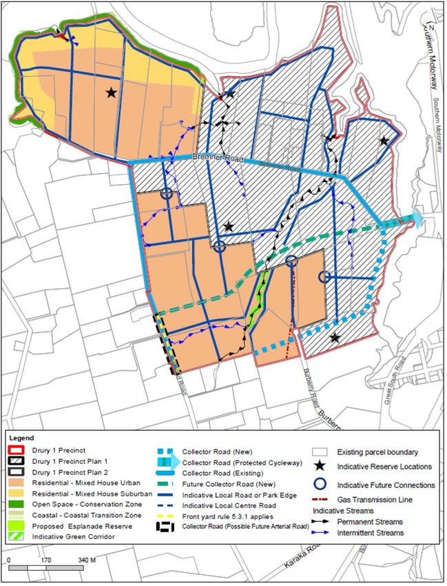
| Introduction |

Revision History
 Revision Nº              Prepared By                                      Description                                                            Date
 0.1                      Kara Hartshorne                                  First draft for client and legal review                                28/03/19

 0.2                      Kara Hartshorne                                  Second Draft for Auckland Council                                      05/04/19

 0.3                      Kara Hartshorne                                  Third Draft including pre-application                                  12/06/19
                                                                           comments from Auckland Council and
                                                                           Auckland Transport
 0.4                      Skip Fourie                                      Updated Draft ITA for comment                                          08/12/2020

 1.0                      Skip Fourie                                      Final ITA                                                              19//01/2021

Document Acceptance
 Action                   Name                                             Signed                                                                 Date
 Prepared by              Skip Fourie                                                                                                             19//01/2021

 Reviewed by              Joe Phillips                                                                                                            19//01/2021

 Approved by              Jamie Swan                                                                                                              19//01/2021

 on behalf of             Beca Limited

© Beca 2021 (unless Beca has expressly agreed otherwise with the Client in writing).

This report has been prepared by Beca on the specific instructions of our Client. It is solely for our Client’s use for the purpose for which it is intended in accordance
with the agreed scope of work. Any use or reliance by any person contrary to the above, to which Beca has not given its prior written consent, is at that person's own
risk.

                                                                                             Drury West Secondary School and ECE ITA| 4216997 | 1.0 | 19 January 2021 | 1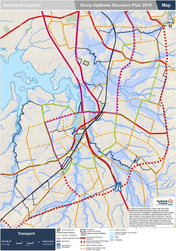
| Introduction |

Contents

1   Introduction ........................................................................................................ 3
    1.1    Background ...................................................................................................................................... 3
    1.2    Timing and Staging .......................................................................................................................... 3
    1.3    Liaison with Auckland Transport and the Waka Kotahi NZ Transport Agency ................................ 3
    1.4    Structure of Report .......................................................................................................................... 4

2   Land Use and Transport Environment ............................................................ 5
    2.1    Location ........................................................................................................................................... 5
    2.2    Surrounding Land Use ..................................................................................................................... 6
    2.3    Existing Transport Network .............................................................................................................. 9
    2.4    Future Transport Network .............................................................................................................. 10

3   Proposed Development................................................................................... 19
    3.1    Secondary School & ECE site ....................................................................................................... 19
    3.2    Access Strategy ............................................................................................................................. 19
    3.3    Pick Up and Drop Off Arrangements ............................................................................................. 21
    3.4    Parking and Loading Areas ........................................................................................................... 21

4   Predicted Mode Share and Trip Generation .................................................. 22
    4.1    Anticipated Catchment ................................................................................................................... 22
    4.2    Mode Share ................................................................................................................................... 23
    4.3    School Travel Plan ......................................................................................................................... 25
    4.4    Predicted Trip Distribution ............................................................................................................. 25

5   Assessment of the Transport Effects and Mitigation .................................. 26
    5.1    Traffic Modelling ............................................................................................................................ 26
    5.2    Transport Impact Assessment Liaison .......................................................................................... 26
    5.3    Site Access Effects ........................................................................................................................ 26
    5.4    Jesmond Road and Surrounding Transport Network Operation ................................................... 28
    5.5    Pedestrian and Cycle Effects......................................................................................................... 30
    5.6    On-Street Parking Effects .............................................................................................................. 33
    5.7    Public Transport Effects ................................................................................................................. 33
    5.8    Construction Traffic Effects ............................................................................................................ 33
    5.9    Summary of Recommended Mitigation Measures......................................................................... 33

6   Summary and Conclusions ............................................................................ 35

                                                                                    Drury West Secondary School and ECE ITA| 4216997 | 1.0 | 19 January 2021 | 2
| Introduction |

1     Introduction

1.1     Background
This Integrated Transport Assessment (ITA) has been undertaken by Beca Limited (Beca) on behalf of the
Ministry of Education (Ministry) to support the proposed designation of land for a new secondary school (Years
7 – 13) and an early childhood education centre (ECE) in Drury West, Auckland. The site location is shown on
Figure 2-1.

This ITA provides a high-level transport assessment recognising that the timing and nature of the future growth
in this area is still uncertain, as well as dynamic in the current policy setting of Auckland Council (AC).
Irrespective, this ITA identifies potential transport effects on the basis of known future networks and makes
recommendations to address any potential adverse transport effects that may arise from the operation of the
school and ECE.

The Supporting Growth Programme is planning for growth in Auckland, including the south, where the school
and ECE site will be located. Specifically, the Programme is investigating and planning the transport network
to support Auckland's urban growth over the next 30 years. There is also development occurring in
surrounding area including in the Auranga Precinct, as well as more recent plan changes in the Drury West
area.

1.2     Timing and Staging
The Minister of Education (the Minister) has not announced an opening date for the secondary school and /or
ECE on this site and this will largely be subject to the uptake and occupation of residential growth in the
surrounding area.
It is anticipated that the school will have a small roll of foundation students that will grow gradually over time.
For the purposes of the Ministry’s Schools Network Planning, a foundation roll of approximately 200 – 300
students have been assumed and roll growth to approximately 2,500 students over the following 15 years is
predicted. The ECE is anticipated to have a roll of 50 children and 10 staff when fully operational.

1.3     Liaison with Auckland Transport and the Waka Kotahi NZ Transport
        Agency
Meetings were undertaken with Auckland Transport (AT) and the Waka Kotahi NZ Transport Agency (Waka
Kotahi) in 2019 to assist with developing this ITA. At an earlier meeting (14th March 2018) to discuss the Notice
of Requirement (NoR), it was agreed that modelling was not required for the SH22/Jesmond Road intersection
or within the Auranga development area. This is further discussed in Section 4 of the report.

A pre-application meeting was held with AC and AT on 15th April 2019 with a draft ITA circulated ahead of the
meeting. Written preliminary pre-lodgement feedback was received from AT and AC and these comments
have been incorporated within this ITA.

Further meetings have been scheduled in November and December 2020 to expand on the inputs already
received from AC, AT and Waka Kotahi. The ITA will be updated with an addendum once more information is
available.

                                                              Drury West Secondary School and ECE ITA| 4216997 | 1.0 | 19 January 2021 | 3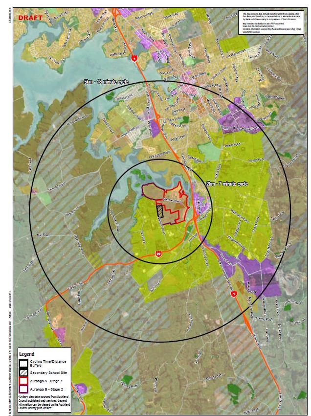
| Introduction |

1.4     Structure of Report
The ITA is structured as follows:
● Chapter 2 discusses the land use and transport environment
● Chapter 3 describes the proposed development of the site for a secondary school and ECE
● Chapter 4 predicts the mode share and trip generation for the site
● Chapter 5 provides a high-level assessment of the transport impacts
● Chapter 6 provides a summary, together with the conclusions and recommendations.

                                                       Drury West Secondary School and ECE ITA| 4216997 | 1.0 | 19 January 2021 | 4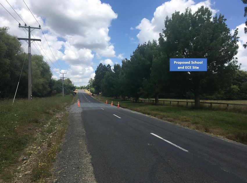
| Land Use and Transport Environment |

2     Land Use and Transport Environment

2.1 Location
The site subject to this notice of requirement comprises land at 281, 401 and 341 Jesmond Road as shown
outlined and shaded in yellow below, hereafter referred to as ‘the site’.
The site is located in Drury West approximately 39km south of the Auckland CBD, 19km south of Manukau
City and 8.5km south-west of Papakura. The site is approximately 3km west of Drury township. Approximately
1.4km to the east of the site is State Highway 1 (SH1) and approximately 1.5km to the south of the site is State
Highway 22 (Karaka Road).

Figure 2-1: Location of the Secondary School and ECE Site

                                                            Drury West Secondary School and ECE ITA| 4216997 | 1.0 | 19 January 2021 | 5
| Land Use and Transport Environment |

2.2 Surrounding Land Use
Private Plan Change 6 (PC 6) – Auranga (B1) Drury West to the Auckland Unitary Plan: Operative in Part
(AUP) was made operative in full on 14 February 2020 and zoned the site from “Future Urban” to “Residential
Mixed Urban”. Auranga B1 proposes to develop approximately 1,300 residential dwellings.

Karaka and Drury Ltd “KDL” are implementing a new residential development within Drury 1 Precinct (Auranga
A). The site is located within the Auranga B1 development area. If implemented, Auranga A and B1 will
provide for approximately 3,000 residential dwellings.

The foundation roll students (secondary and ECE) are likely to come firstly from the Auranga A development,
followed by Auranga B1, and then the Future Urban Zoned (FUZ) land to the west and the south of the site.
The proposed secondary school site in relation to the Auranga A & B1 development and the FUZ is shown on
Figure 2-2 and Figure 2-3. It is also noted that Plan Change 51 for the next stage of Auranga, south of B1
and bordering SH22 has been lodged recently.

                                                         Drury West Secondary School and ECE ITA| 4216997 | 1.0 | 19 January 2021 | 6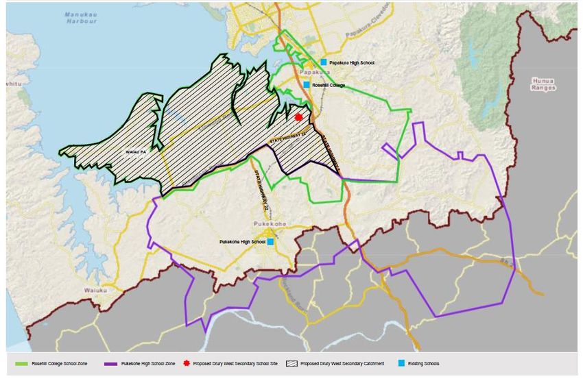
| Land Use and Transport Environment |

Figure 2-2: Proposed Drury West Secondary School and ECE Site in relation to Auranga A and B1

                                                             Drury West Secondary School and ECE ITA| 4216997 | 1.0 | 19 January 2021 | 7
| Land Use and Transport Environment |

Figure 2-3: Proposed Drury West Secondary School and ECE Site in relation to Auranga A and B1

The current surrounding land use is predominantly rural and rural-residential land use as seen in Figure 2-4.
When Auranga has been completed and the FUZ land is developed the school and ECE will be centrally
located within the overall residential catchment.

                                                             Drury West Secondary School and ECE ITA| 4216997 | 1.0 | 19 January 2021 | 8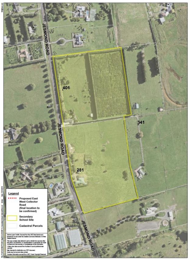
| Land Use and Transport Environment |

2.3 Existing Transport Network

2.3.1 Existing Road

Jesmond Road is currently an existing local rural road that connects with Bremner Road in the north and SH22
to the south (refer to Figure 2-4). It currently provides local access to rural residential properties and a local
business. The posted speed limit on Jesmond Road is 60km/hr and provides for one lane in each direction
with a centre line. The school site is approximately 1.5km from the intersection with SH22 and 425m from the
intersection with Bremer Road.

Figure 2-4: Jesmond Road looking north towards Bremner Road (4th February 2019)

2.3.2   Existing Public Transport Network
No public bus services operate close to the school site and the only service in the vicinity is Route 376,
which travels between Papakura rail station and Drury. The provision of future bus services is the
responsibility of AT.
The nearest train station is in Papakura on the Southern Line, which is approximately 9km from the site.
Although this is a considerable distance from the school site, parents have the opportunity to drive to the station
after dropping children off at the school and ECE and catch the train into the city.

                                                              Drury West Secondary School and ECE ITA| 4216997 | 1.0 | 19 January 2021 | 9
| Land Use and Transport Environment |
2.3.3 Existing Walking and Cycling Network
The immediate surrounding area is rural and rural residential and does not have a walking and cycling network.
Jesmond Road has no on or off-road pedestrian and cycling facilities.
2.4 Future Transport Network
2.4.1 Staging of the Future Road Network
As set out in PC6 – “The transport provisions for Precinct Plan 2 recognise that Auckland Transport and the
NZ Transport Agency have not yet completed planning the strategic transport network for the wider Drury area
including the Future Urban zones to the west and south of the Drury 1 Precinct. The precinct provisions
recognise and support future strategic transport connections which may be required to and through the precinct
- in particular Jesmond Road and the new east-west road (Future Collector Road)”.
“The Jesmond Road / SH 22 intersection upgrade is required prior to development in Precinct Plan 2. Other
transport infrastructure upgrades outside of the precinct have not been prescribed in the same manner.
However, the Precinct recognises the potential for adverse traffic effects at five identified intersections and the
Norrie Road one-way bridge. Those effects will be assessed at the time of subdivision applications and
required upgrades or other mitigation determined at that time”1.
There is currently no known development planned along Jesmond Road and, as such, the timing and staging
of the upgrade of Jesmond Road is not known. Further, the land zoned FUZ to the west or south does not
have an approved plan change and the Supporting Growth Programme is still to confirm the future transport
network in this area.
2.4.2 Supporting Growth Programme
As part of the Supporting Growth Programme, the public were consulted (in 2018) on two options for improving
connections for Drury-West and Opāheke. Both these options propose a new north south corridor between an
“east-west connection” and the new expressway. The two options include:
● Option 1: One corridor for all transport modes (cars, buses, walking and cycling). A new north-south link
between the east-west corridor and the new expressway. This could be a frequent bus carrier connecting
the train stations, centres and employment areas.
● Option 2: Two corridors:
– 2(a) Greenfields alignment between Jesmond Road and Oira Road- A new north-south corridor
prioritising public transport. This could be a frequent bus carrier connecting the train stations, centres
and employment areas.
– 2(b) Jesmond Road – A new north south corridor for cars, walking and cycling.
Both these options include a porposed new train station in close proximity to a town centre. It is noted that the
preferred transport network and timeframes are yet to be endorsed by both Waka Kotahi and AT Boards (this
is anticipated during June 2019). As such, these are only indicative corridors and have no statutory weighting.
2.4.3 Drury-Opaheke Structure Plan – August 2019
The Drury Opaheke Structure Plan has been finalised (dated August 2019) following public consultation.
According to the Structure plan feedback - The importance of the new roads and infrastructure being built as
1
Plan Change 6, Auranga B1 Drury West, Operative 14 February 2020
Drury West Secondary School and ECE ITA| 4216997 | 1.0 | 19 January 2021 | 10| Land Use and Transport Environment |
soon as possible, particularly before any significant development occurs. There was a general support towards
the proposed transport network as a whole and improved connectivity – including specific comments on the
road network, public transport and walking and cycling.
The proposed transport network (Figure 2-5) identifies the following key roads adjacent to the site:
● Arterial Network
– New east-west strategic connection (Bremner Road extension) between Jesmond and Great South
Roads. With frequent and express bus services.
– Upgrade Jesmond Road between Bremner Road and SH 22.
● Collector Road Network
– The new East-West Collector Road
Site
Figure 2-5: Drury Opaheke Structure Plan Aug 2019 - Transport Network
Drury West Secondary School and ECE ITA| 4216997 | 1.0 | 19 January 2021 | 11| Land Use and Transport Environment |
It is noted that the proposed transport network included in the Structure Plan is based on the transport network
which is subject to Waka Kotahi and AT Boards approvals and are therefore indicative only and subject to
change. The consultation draft Structure Plan is consistent with the assumptions in the ITA, where Jesmond
Road, along the school frontage, is identified as an Arterial Road with connector/local bus services.
2.4.4 Jesmond Road
Jesmond Road is on the western frontage of the site and is identified to be upgraded to a Collector Road
(Existing) in the AUP as seen in Figure 2-6.
Site
Figure 2-6: Drury Precinct Plan 2 – AUP - Drury 1 Precinct
Drury West Secondary School and ECE ITA| 4216997 | 1.0 | 19 January 2021 | 12| Land Use and Transport Environment |
A short distance of Jesmond Road, along the site frontage, is identified to be upgraded to Collector Road
(Future Arterial Road). It is recognised that the length of Jesmond Road which fronts the school will be provided
by developers and vested in AT when upgraded.
The characteristics of the Collector Road are shown on the cross section below in Figure 2-7 as included as
in the Drury 1 section of the AUP. This includes a wide road reserve with:
● Two traffic lanes of 3 – 3.5m wide
● 3m shared path on both sides of the road
● 1.8m – 2.2m on-road cycle lane on both sides
● A wide landscape strip (2.2 – 2.6m) with street trees, stormwater devices and parking on both sides
Figure 2-7: Indicative Cross Section of Collector Road (Existing)2
The existing road reserve of Jesmond Road on the school frontage is approximately 20m. It is anticipated
that the existing road reserve width will be able to accommodate a cross section from the school boundary
(right hand side of cross section) to the left hand side of the cross section kerb of 18.7m + 1.3m berm without
the need for land acquisition. The 18.3m width from the school boundary on the right to the kerb on the left is
shown in blue on Figure 2-7 above and includes the following:
● 0.7m berm
● 3m footpath/shared path
● 1m berm
● 2.6m parking/street tree/stormwater devices
● 2 x 2.2m cycle lanes
● 2 x 3.5m traffic lanes
It is recognised that this 20m cross section may need to be altered outside the school frontage and it is
considered that the parking/street trees could be removed in those specific locations to enable
driveways/intersection and associated visibility splays. School buses could utilise the pick-up and drop-off
2
Figure 4, AUP, Drury 1 Precinct
Drury West Secondary School and ECE ITA| 4216997 | 1.0 | 19 January 2021 | 13| Land Use and Transport Environment |
(PUDO) on site and the location of any AT Metro scheduled bus stops to be used by students will be
determined as part of AT’s wider planning for bus services. It is considered that the parking/street trees can
be removed in those specific locations to accommodate bus stops. The locations of these will be considered
and discussed with AT when the TIA is prepared.
The above cross section is incorporated in the Drury 1 Precinct section of the AUP and it is considered to be
the most appropriate design rather than the cross sections identified in the Drury- Opāheke and Pukekohe-
Paerata Structure Plan ITA. Details surrounding the cross sections will be subject to possible changes in the
subsequent design stages.
2.4.5 East West Collector Road
The AUP and Drury- Opāheke Structure Plan identifies the East-West Collector Road (Proposed) aligning to
the south of the site of the secondary school and ECE (refer to Figure 2-5 and Figure 2-6). It is referred to as
the “Future Collector Road (New)” and will provide a new east-west transport connection between the existing
Drury Town Centre and an indicative potential new local town centre in Drury West as shown on the 2016
Preferred Network Plan for the South3.
For the purposes of this ITA it has been assumed that the East-West Collector Road will be located along the
southern boundary of the school site. It is likely that an interim local road with a cross section of 15.8m will be
constructed first and will have the formation as shown in Figure 2-8 from Plan Change 6. The new east-west
connection will accommodate vehicles, pedestrians, cyclists and public transport.
Figure 2-8 Road I Future Collector Road (New) – Interim Local Road Formation (Source: AUP)
2.4.6 Bremner Road
Bremner Road will be one of the main roads used to access the site on opening. The approved cross section
for Bremner Road is shown below in Figure 2-9.
3
https://www.nzta.govt.nz/assets/projects/supporting-Growth-Delivering-transport-networks/south/network-
for-the-south.pdf
Drury West Secondary School and ECE ITA| 4216997 | 1.0 | 19 January 2021 | 14| Land Use and Transport Environment |
Bremner Road is currently being upgraded as part of the Auranga subdivision consents. Previous discussions
with KDL in 2019 indicated that the construction on the western half of Bremner Road (western boundary of
207 Bremner Rd to Jesmond Road) was programmed to begin in late 2019. The current staging of the upgrade
is not known. However, as the whole length of Bremner Road is located in the Auranga A area of PC6, it is
considered highly likely it will be upgraded, including to the intersection with Jesmond Road, well before any
school opens on the site.
Figure 2-9 Approved cross section of Bremner Road (Source: KDL)
2.4.7 Jesmond Road / SH22 Intersection
The Ministry met with Waka Kotahi (on March 2019) and the proposal at the time for this intersection was to
implement a right turn bay from SH22 into Jesmond Road. The right turn bay has now been implemented
and this is likely to be an interim solution.
According to PC6 – “Prior to the occupation of any new dwelling or unit in the Precinct Plan 2 area, the
intersection of SH22 and Jesmond Road must be upgraded with a double lane roundabout with approach
lanes, or traffic signals (including approach lanes) where the posted speed limit supports their implementation
to provide a safety and capacity solution, unless an interim traffic safety solution has been approved by the
New Zealand Transport Agency as the requiring authority for State Highway 22. This rule states:
● Also applies to integrated residential developments sought as a land use consent application; and
● Continues to apply to each application for subdivision or development within the Precinct Plan 2 area until
such time as the intersection of State Highway 22 and Jesmond Road has been upgraded with a double
lane roundabout or traffic signals”.
The AUP - PC6 requires this intersection to be upgraded before residential development in this area.
Subsequently, the provision of this new secondary school and ECE is contingent on the residential
development to have been progressed. In summary, the intersection of Jesmond Road and SH22 will be
upgraded well in advance of the full school roll being taken up.
2.4.8 Proposed Transportation Upgrades
Commute has prepared an ITA for both Auranga A and Auranga B1 and undertook traffic modelling for both
these areas. The modelling undertaken for both these ITA’s identified the transportation upgrades required
Drury West Secondary School and ECE ITA| 4216997 | 1.0 | 19 January 2021 | 15| Land Use and Transport Environment |
either prior to occupation of any dwellings or at some point as the land is built out in order to ensure the
surrounding road network will perform to acceptable standards.
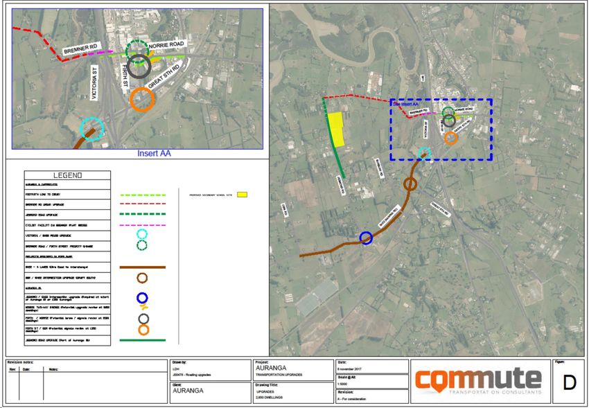
The location of these transport upgrades in relation to the site is shown in Figure 2-10. It is noted that some
of the upgrades for Auranga A have already started. The exact timing for when each transportation upgrade
might be required will depend on the sequence of development. As can be seen from Figure 2-10 there are
numerous transportation upgrades surrounding the site.
Figure 2.9 shows that the upgrade of Jesmond Road, outside the site, has been identified as being required
for Auranga A and Auranga B1. However, it is recognised that the length of Jesmond Road fronting the site
will be most likely be provided by developers and vested in AT.
2.4.9 Walking and Cycling
The proposed cross sections of Jesmond Road and the East-West Collector Road include a 3m shared path
and on-road cycle lane on both sides of the road.
A wide landscape strip with rain gardens, street trees, stormwater treatment dispersed with parking will make
it a pleasant environment for pedestrians and cyclists. These design features will enhance walking and cycling
opportunities to the site. It is also recognised that school students may choose to scooter to school and the
proposed high-quality walking and cycling facilities will also encourage this active mode.
The AUP contains special provisions for the Drury 1 and 2 Precinct and the objectives focus on walkable
neighbourhoods and a well-connected roading layout that supports a range of travel modes including walking
and cycling.
The policies to achieve this include maximising vehicular, cycling and pedestrian connectivity and permeability
of the road network wherever possible. The policies also require pedestrian links to allow for safe and efficient
movements. Further policies require future subdivisions to be designed to support liveable, walkable and
connected neighbourhoods including a road network that is easy and safe to use for pedestrians and cyclists
and connected to schools.
These objectives and policies apply to the road network planned throughout the whole Drury 1 and 2 Precinct;
which for the purposes of this report, have been used to provide guidance around the future walking and
cycling effects and opportunities for the planning and design of the School site.
Drury West Secondary School and ECE ITA| 4216997 | 1.0 | 19 January 2021 | 16| Land Use and Transport Environment |
Figure 2-10 Proposed Transport Upgrades for Auranga A and B1 (Source: Auranga B1 Modelling Technical Memo )
Drury West Secondary School and ECE ITA| 4216997 | 1.0 | 19 January 2021 | 17| Land Use and Transport Environment |
2.4.10 Public Transport
A potential future rail station in Drury West is currently being investigated as part of the Supporting Growth
Programme. This investigation is also looking at rail electrification between Pukekohe and Papakura to improve
services in this area. If approved, there is potential for parents/caregivers to catch the train after dropping
children off at the school and ECE. It may also be used by secondary school students coming from the wider
catchment.
The Drury- Opāheke Structure Plan identifies Jesmond Road (between Bremner Road and the East-West
(New Arterial Road)) as a Collector Road (Existing) with Connector/Local bus services.
2.4.11 Future Traffic Volumes
Jesmond Road and the proposed East-West road are both identified as collector roads in the AUP. The
Auckland Transport Code of Practice (ATCOP) identifies that collector roads are likely to be designed to carry
typically traffic volumes of around 10,000 vehicles per day.
However, review of the future transport network as signalled by the Supporting Growth Programme, indicates
that the volumes on Jesmond Road (between Bremner Road and the proposed East-West Collector Road)
would likely be less than the proposed East-West Collector Road, which would have more of a distribution/
arterial function.
The proposed network indicates the main movements within Drury West will be east-west on the East-West
Collector Road to distribute traffic on to the north-south connection.
By comparison, Jesmond Road to the north of the East-West Collector Road is considered to simply collect
vehicles from surrounding local roads in the Auranga A and B1 areas to the north of the site and then connect
with these distributor roads to the south of the site.
Drury West Secondary School and ECE ITA| 4216997 | 0.4 | 30 November 2020 | 18| Proposed Development |
3 Proposed Development
3.1 Secondary School & ECE site
The proposed secondary school is expected to have a foundation student roll of approximately 200-300
secondary students. Depending on the rate of residential growth in the area the Ministry anticipates that the
school may ultimately have a roll of approximately 2,500 secondary school
For a school of 2,500 capacity it is anticipated that approximately 140 staff will travel to and from the site.
The ECE is anticipated to have a roll of 50 children and 10 staff.
3.2 Access Strategy
Jesmond Road is on the western boundary and is identified in the AUP to be upgraded to a Collector Road
(Existing). An East -West Collector Road (Interim and New) is identified in the AUP along the southern frontage
of the site however it is recognised this Collector Road will have more of an arterial function.
An indicative access strategy is shown on Figure 3-1 and described below:
● Main vehicular access for the school and ECE from Jesmond Road for staff/student car parking and
PUDO.
● Opportunities for access from other roads may be provided off the future road network when constructed.
● Pedestrian and cycle/e-scooter access from Jesmond Road on the western frontage and the East -West
Collector Road (Interim and New) on the southern frontage.
A Design Concept Plan will be prepared as part of the Establishment Outline Plan (OP) showing the number
and general location of access points for vehicles, cyclists/e-scooters and pedestrians.
3.2.1 Access to 341 Jesmond Road
Currently access to 341 Jesmond Road is via a right of way located between 401 and 281 Jesmond Road
(Right of Way) as seen on Figure 3-1. At the time of this report the Ministry is negotiating to purchase part of
the Right of Way.
The right of way will remain in use until such time as the Ministry acquires part of that land and subsequently
requires that for construction or operation of the school and ECE. If the East-West Collector road has not
already provided road access to 341 Jesmond Road at that time, the Ministry could provide alternative access
that does not bisect the school site. This could, for example, be achieved by the granting a right of way
easement in favour of 341 Jesmond Road along the southern boundary of the Site.
A further alternative access in the middle of the site is considered an inefficient use of the site as a whole and
is not recommended. The alternative access will be determined closer to the time of the school opening and
as part of the OP.
The designation of the Site will not preclude the ongoing use of the right of way for access to 341 Jesmond
Road for so long as the right of way easement remains effective.
Drury West Secondary School and ECE ITA| 4216997 | 1.0 | 19 January 2021 | 19| Proposed Development |
Right of Way
Figure 3-1 Proposed Access Strategy for the site
Drury West Secondary School and ECE ITA| 4216997 | 1.0 | 19 January 2021 | 20| Proposed Development |
3.3 Pick Up and Drop Off Arrangements
It is very likely that a PUDO facility would be provided wholly on the subject site, which would provide a safe
environment for students, parents and staff. The location and design will be confirmed at the OP stage when
a greater level of detail is known about the proposed surrounding school bus, public bus and rail network. The
PUDO facility will be provided at the same time the school is being developed.
The site is sufficiently sized (8.4 ha) to provide an on-site PUDO facility for the secondary school and the ECE.
3.4 Parking and Loading Areas
The 8.4ha site is sufficient size to accommodate parking and loading areas for the school and ECE.
It is recommended that a Design Concept Plan for the site be prepared as part of the OP and the general
location of parking areas (including cycle/scooter parks) be included in this plan.
Drury West Secondary School and ECE ITA| 4216997 | 1.0 | 19 January 2021 | 21| Predicted Mode Share and Trip Generation |
4 Predicted Mode Share and Trip Generation
4.1 Anticipated Catchment
For the purposes of this ITA the indicative catchment for the new secondary school and ECE is shown on
Figure 4-1. The catchment can be described as the Drury West area, between SH1 and Waiau Pa and south
to the enrolment zone for Pukekohe High School.
It is noted that the secondary school catchment is indicative only and the final catchment will be subject to
discussions between the Establishment Board of the new school (once appointed) and the Boards of Rosehill
College, Papakura and Pukekohe High Schools. It is noted that it is likely that Rosehill College’s zone would
likely be amended so that it excludes Drury West but includes the Hingaia area.
It is noted that Waiau Pa, Kingseat and Karaka areas are included in the indicative Drury West secondary
school catchment and predominantly have a rural zoning. The new secondary school is not expected to draw
a significant number of students from these areas.
The more immediate catchment is shown below in overlain on the Auckland Future Urban Land Supply
Strategy (FULSS) for Hingaia, Opāheke-Drury and Drury West as seen in Figure 4-2.
Figure 4-1 Indicative Catchment for Drury West Secondary School
Drury West Secondary School and ECE ITA| 4216997 | 1.0 | 19 January 2021 | 22| Predicted Mode Share and Trip Generation |
Figure 4-2 Anticipated Catchment for the Secondary School and ECE (Source: Auckland Future Urban Land Supply
Strategy, Auckland Council, July 2017)
The proportion of students attending the secondary school from Drury West Stage 1, Drury West Stage 2 and
the other rural areas have been estimated and shown in Table 4-1 below.
Table 4-1 Assumed Secondary School Distribution
Area Distribution Proportion Number of Students
Drury West Stage 1 50% 1,250
Drury West Stage 2 40% 1,000
Rural / Other Areas 10% 250
Total 100% 2,500
4.2 Mode Share
As students get older, they travel more independently with higher proportions of secondary students walking,
cycling and using public transport compared to primary school.
The mode share for the school will change as the residential area around the secondary school and the
transport network is developed. The desired future mode share outcomes for the school seek to have high
pedestrian and active mode share as the roll progressively reaches 2,500 students.
For Drury West Stage 1 most of this area is within an appropriate cycling distance of the school site. Therefore,
it is expected there will be a higher walking and cycling mode share.
For Drury West Stage 2 it is noted that SH22 will provide a barrier to walking and cycling and there will be
more of an emphasis on car and public transport travel.
Drury West Secondary School and ECE ITA| 4216997 | 1.0 | 19 January 2021 | 23| Predicted Mode Share and Trip Generation |
Table 4-2 shows a predicted mode share for the school for 2,500 students for Drury West Stage 1 and Drury
West Stage 2 areas.
Table 4-2: Predicted Mode Share – Roll of 2,500 students
Student Mode Share Drury West Stage 1 Drury West Stage 2 Rural / Other
Car 20% 30% 30%
Cycle / E-Scooter 10% 10% 0%
Walk 40% 0% 0%
Public Transport (buses) 30% (375 students) 60% (600 students) 70% (175 students)
Total 100% 100% 100%
For the staff a mode share of 80% vehicle and 20% active modes has been assumed.
Table 4.2 provides the number of students by area anticipated to use buses to travel to and from school. The
split of the number of students using public and private buses is unknown at this stage and will be developed
further, as part of the bus strategy, to be included in the School Travel Plan.
4.2.1 Secondary School Vehicle Trips
Applying the assumed pupil distribution by area and mode shares to the proposed number of secondary school
students and associated staff the predicted number of vehicle trips generated has been calculated and the
following vehicle occupancy rates applied:
● 1.26 students per vehicle4
● 1 person per vehicle for staff
Applying these vehicle occupancy rates generates a total of approximately 1,065 vehicle movements (in + out)
for the secondary school associated with the morning arrival period and the same number of movements in
the afternoon departure periods for a full school roll anticipated around 2043. A full breakdown of the predicted
vehicle movements is presented in Table 4-3 below.
Currently the Ministry does not have a policy of providing for student car parking on site. Student travel demand
management, will be a matter for addressing in the School’s Travel Plan, developed in consultation with AT
and the elected Board of Trustees (as opposed to the Establishment Board of Trustees). This is discussed in
more detail in Section 4.3.
Table 4-3: Predicted Secondary School Vehicle Generation – Full Roll of 2,500 students
Car Mode Number of Students / Vehicles Vehicle Movements Generated (in + out) for
Share Staff Travelling by car Generated each of the morning and afternoon periods
Drury West Stage 1 20% 250 199 398
Drury West Stage 2 30% 300 238 476
Rural / Other 30% 75 47 94
Staff 80% 112 112 112
Total 837 697 1,080
4
Waka Kotahi’s school travel model spreadsheet
www.nzta.govt.nz/assets/resources/research/reports/467/docs/nzhts-school-travelmodel.xls
Drury West Secondary School and ECE ITA| 4216997 | 1.0 | 19 January 2021 | 24| Predicted Mode Share and Trip Generation |
4.2.2 Summary of Trips
It is anticipated for a full school roll of 2,500 students the following number of trips by mode are:
● Pedestrian = Approximately 500 students walking to and from school
● Cycle / E-Scooters = Approximately 225 students cycling/scootering to and from school
● Public Transport (Buses) = Approximately 1,150 students using public transport to and from school
● Private Car = Approximately 1,080 vehicle movements (in + out) for each of the morning and afternoon
drop-off and pick-up periods.
4.2.3 ECE Trips
It has been estimated that the ECE is expected to have a vehicle mode share of 80% private car and 20%
walking for both staff and children based on previous experience of ECE facilities across Auckland. In addition
to the daily school vehicle generation, this equates to a vehicle generation of 80 daily vehicle trips for the
children and 16 vehicle trips for the staff.
4.3 School Travel Plan
It is recommended that a School Travel Plan is developed within six months of the opening of the secondary
school once an elected Board of Trustees is in place to assist in supporting and achieving the desired mode
share.
The purpose of the School Travel Plan is to provide specific measures to reduce vehicle dependence, including
carpooling, the encouragement of the use of public transport and the encouragement of walking and cycling.
The School Travel Plan is also required to be consistent with AT’s Travelwise programme and provide the
location and provision of any scooter and cycle parking required.
It is recommended that the Travel Plan include details of the school bus strategy for both public and private
buses. The strategy is likely to include the areas of Clarks Beach, Kingseat, Waiau Pa and Karaka which are
rural areas within the anticipated school catchment where the mode share of bus travel is anticipated to be
high.
Although the Ministry does not have a policy of providing for student car parking on site it is recognised that
some older students may drive and/or attend before and after school activities. It is recognised that the school
will start with an initial small roll and these are likely to be younger students who are unable to drive. It is
recommended that measures to manage the effects of student parking on the surrounding network be
considered within the TIA and the School Travel Plan that is submitted with the OP. For example, it may be
appropriate to temporarily provide some on-site student parking spaces if the surrounding road network has
not been developed.
4.4 Predicted Trip Distribution
It is anticipated that at opening, the majority of vehicle trips will come from the north and east of the site using
Bremner Road/Jesmond Road intersection, as the first stages of residential development in Auranga A,
followed by Auranga B1.
In the longer term, future phases of residential development are proposed to the west and south of the site.
Students from these areas would use SH22/Jesmond Road intersection to travel to school.
It should be noted that many of the trips will not be generated solely as a result of the school and ECE, rather
that these trips are likely to be trips already on the road network for parents who commute to and from the city.
Any existing modelling and planning for the area would already encompass the trips to and from the school on
the road network.
Drury West Secondary School and ECE ITA| 4216997 | 1.0 | 19 January 2021 | 25| Assessment of the Transport Effects and Mitigation |
5 Assessment of the Transport Effects and Mitigation
5.1 Traffic Modelling
An ITA Report was prepared by Commute Transportation Specialists (Commute) entitled “Auranga B1,
Proposed Plan Change, Bremner Road, Drury, Integrated Transportation Assessment Report” (May 2017) to
support the PC6 (Auranga B1 Drury West) to enable 1,300 new residential houses. 5 The traffic modelling in
the 2017 Commute ITA considered a worst case scenario for school traffic associated with the residential
development, as it assumed that all Auranga residents would need travel to Rosehill College.
As discussed in Section 2.4.8, Commute prepared ITA’s for both Auranga A and Auranga B1. The modelling
undertaken for both these ITA’s identified the traffic and transport upgrades required either prior to occupation
of any dwellings or at some point, as the land is built out, in order to ensure the surrounding transport network
will perform to acceptably. The exact timing for when each transport upgrade will be implemented will depend
on the sequence of development. It is considered that any potential traffic impacts from the operation of the
school and ECE on the surrounding transport network will therefore be addressed by the proposed transport
upgrades shown on Figure 2-10 and through the preparation of a TIA for the school, as discussed in Section
5.2.
It is understood that the roads will have been designed to accommodate 10 or 20 years of growth within the
Drury West area and will provide more than satisfactory performance in the early stages of residential growth
including the secondary school.
It is assumed Rosehill College will stay open and the proposed new secondary school is unlikely to attract trips
from a wider catchment than the Drury West area. While it is acknowledged that in the early stages after
opening there may be some trips from out of zone these can be more than satisfactorily addressed by the
transport upgrades discussed in Section 2.4.8 and shown on Figure 2-10.
5.2 Transport Impact Assessment Liaison
In this particular case the NoR has been lodged in advance of likely construction of the School and ECE. There
is therefore inherent uncertainty, which is reflected in the assumptions this report makes and the high-level
nature of the assessment undertaken.
It is therefore recommended a detailed TIA is prepared at the OP stage, when the land use and transport
environment information are better known and there is increased certainty.
It is recommended that the preparation of the TIA is undertaken in liaison with AT and Waka Kotahi, such that
a clear understanding of the transport network development informs the TIA.
5.3 Site Access Effects
5.3.1 Staging and Timing
Jesmond Road is currently a rural road with no pedestrian and cycle facilities and will most likely need to be
upgraded to provide safe access to the site, depending on the travel modes. There is currently no known
5
The closest secondary schools are Rosehill College (to north) and the Wesley College (to south) located approximately 6km away and
not within walking or cycling distance of the Auranga B1 population. Pukekohe High School is also located further to the south. As
such, the secondary educational needs of the population would need to be met by residents undertaking external trips to these
secondary schools.
Drury West Secondary School and ECE ITA| 4216997 | 1.0 | 19 January 2021 | 26| Assessment of the Transport Effects and Mitigation |
development planned along Jesmond Road and as such the timing and staging of the upgrade of Jesmond
Road is not known at this stage.
There could be a scenario, when the school is established, that Jesmond Road has not been upgraded. Refer
to Section 5.4.1 for the initial 200 school roll impacts on the existing intersection. This is recommended to be
considered in the TIA (during the Establishment Outline Plan) which will be prepared at the appropriate time
when further detailed information (and therefore more certainty) is available.
5.3.2 Vehicle Access Considerations
The site is capable of providing vehicle access from Jesmond Road. The site has 460m of frontage, which
provides more than sufficient separation distance between the anticipated vehicle access points. Multiple
vehicle access points can therefore be provided, and this can distribute the traffic to the various locations in
the site, such as for staff/visitor car parking, a PUDO and the ECE. Having multiple vehicle access points will
distribute the anticipated demand. Jesmond Road is a straight section of road along most of the site frontage
and appropriate sightlines for access points can therefore be achieved.
Matters to be considered in developing the access points to the site are:
● proximity to adjacent intersections (e.g. Jesmond Road/Future East-West Collector Road)
● interface with driveways located on western side of Jesmond Road
● interface with bus stops and any on-street parking
● vertical alignment of Jesmond Road.
It is recommended that these matters are assessed at the OP stage during the preparation of the TIA, as part
of assessing safe access to the site for all modes. This would include the potential conflict between the
difference transport modes accessing the site (i.e. pedestrian, cyclists and vehicles) and it is recommended
the TIA consider appropriate measures and treatments to minimise and manage these conflicts.
The public consultation material for the Supporting Growth Programme suggests the traffic volumes on
Jesmond Road (between the intersection with East-West Collector Road and Bremner Road) are likely to be
lower than a typical Collector Road and lower than the proposed East-West Collector Road, which has more
of a distribution function in terms of connecting with the future north-south corridor to a proposed town centre.
It is therefore considered that the main through traffic movements will be east-west on the East-West Collector
Road. The lower traffic volumes on Jesmond Road will assist in enabling this to provide for its safe operation
for vehicles accessing the school.
5.3.3 Form of Vehicle Access
The form of vehicle access for the school off Jesmond Road has not been determined as part of this high-level
assessment, particularly as it will need to integrate with the site layout and will depend on the number of access
points. However, it may be that some form of intersection, rather than driveway crossings, are necessary,
given the anticipated number vehicle movements. It is therefore recommended that the form of access/es is
assessed at the OP stage, as part of the TIA.
5.3.4 PUDO Access
The establishment of a PUDO on the site will be beneficial in terms of providing for these movements on site,
rather than on Jesmond Road. However, further consideration will need to be given to the design of the PUDO
to provide for the anticipated vehicle demand (cars and buses). It is recommended that this is assessed in the
TIA at the OP stage. This would also consider the potential impacts of the PUDO on pedestrians and cyclists,
as discussed in Section 5.5.
Drury West Secondary School and ECE ITA| 4216997 | 1.0 | 19 January 2021 | 27| Assessment of the Transport Effects and Mitigation |
It is recommended that the Travel Plan include details of the school bus strategy for both public and private
buses as well as an estimation of the demand for buses serving the school. The strategy will include the rural
/ growth areas of Clarks Beach, Kingseat, Waiau Pa and Karaka where the mode share of bus travel is
anticipated to be high. The design of the on-site bus PUDO will be informed by the anticipated vehicle demand.
It is considered that the site is large enough to accommodate an on-site PUDO for buses.
5.3.5 Bus Access
Jesmond Road will be designed as a Collector Road and will be able to accommodate buses as the traffic
lanes are designed to be 3 - 3.5m wide. Jesmond Road, along the school frontage, has been identified in the
draft Drury Opāheke Structure Plan as supporting Connector/Local bus services. The school site is sufficient
in size to accommodate on-site PUDO for school buses if required.
It is recommended that bus access and the location of any future bus stops and shelters along the school and
ECE road frontages be included in the TIA as part of the OP stage.
It is also recommended that the assessment of the need for buses to use the PUDO facility for school events
be considered, recognising that this will be a more infrequent event.
5.3.6 Pedestrian and Cycle Access
It is recommended that the pedestrian/cycle access for the secondary school and ECE are separated from
vehicle access. The site is capable of providing for this due its significant frontage of approximately 475m
along Jesmond Road, frontage to the East-West Collector Road and potential future east and north frontages
to other roads (see Section 5.3.7).
It is recognised that vehicle access to the school site will cross a potential future 3m shared path on Jesmond
Road. It is recommended that in order to provide for a safe design for the shared path, consideration be given
to the interaction with school vehicle access. This is more appropriately addressed closer to the time the
school is developed, once the final cross section for Jesmond Road is known.
How the cycle facilities connect to the wider Bremner Road and new arterial road network will be provided be
included in the TIA as part of the OP stage when more information is known closer to the time.
5.3.7 Future Access Points
Whilst it is considered that the access strategy above will appropriately manage the anticipated transport
effects, opportunities for access from any other future roads could also be considered, once the surrounding
transport network/development is better understood. This would provide further flexibility for access and can
be addressed as part of the TIA at the OP stage.
5.4 Jesmond Road and Surrounding Transport Network Operation
Jesmond Road will be appropriate to provide the main vehicular access to the school and, given the anticipated
traffic volumes on this future Collector Road, it is considered that it will have sufficient capacity to accommodate
the predicted secondary school and ECE trips.
However, it is recommended that the TIA prepared at the OP stage:
● addresses the traffic generation, distribution and any necessary means of mitigating adverse effects on
the efficiency and safety of the surrounding transport network.
● Identifies upgrades to, or informs, the design of the Jesmond Road/ Bremer Road, Jesmond Road/ SH22
and Jesmond Road/ East-West Collector Road intersections. Identifies any gaps in the roading network
that would provide a safe connectivity a safe road environment for those travelling to school.
Drury West Secondary School and ECE ITA| 4216997 | 1.0 | 19 January 2021 | 28| Assessment of the Transport Effects and Mitigation |
5.4.1 SH22/Jesmond Road Intersection
The main intersection of interest for Waka Kotahi is the intersection of SH22/Jesmond Road. It was agreed at
the meeting with Waka Kotahi, the Ministry and AT that no traffic modelling is required on the basis that it is
likely the upgrade will already be in place when the school site is developed, and because the traffic/transport
environment will be very different when the school opens. The provisions in the PC6 subdivision controls
clearly require the upgrade of Jesmond Road/ SH22 intersection before subdivision and development can
occur in the Precinct Plan 2 area.
A right turn bay from SH22 into Jesmond Road was implemented in May 2019. It is recognised that the right
turn bay is an interim solution until Waka Kotahi determines its long-term solution which, as noted above, is
expected to be in place before the school opens.
In the unlikely event that the school opened without any surrounding development (and therefore no upgrade
to SH22/Jesmond) it is anticipated that the right-turn bay will be able to accommodate a foundation roll of 200-
300 students. This is because it is anticipated that the catchment for the majority (80%) of the foundation
students (160 to 240 students) will come from the north from Drury Stage 1 and will use the Auranga road
network and Bremner Road. These students will therefore not use the SH22/Jesmond Road intersection. It is
estimated that 20% of foundation students (40 to 60 students) could come from the rural area within the school
catchment to the west of the proposed secondary school.
It is likely that most of these trips will be made by either public transport (buses) or some students may choose
to drive or be dropped off. Assuming 30% of students from rural catchments travel by car and a car occupancy
of 1.4 then this could potentially 9 - 13 cars on SH22. Assuming these are drawn from the western areas of
Kingseat, Clarks Beach these cars will be making a left hand turn into Jesmond Road from SH22 and would
likely not use the right-hand turning bay.
There is uncertainty over the funding, commitment, timing and implementation of the SH22/Jesmond Road
upgrade. Therefore, it is recommended that the potential impact of the school traffic using this intersection is
assessed via the preparation of a TIA at the OP stage. This will assess the traffic generation and any means
of mitigating adverse effects on the efficiency and safety of the surrounding transport network should Waka
Kotahi not have its long-term solution for this intersection in place.
Drury West Secondary School and ECE ITA| 4216997 | 1.0 | 19 January 2021 | 29| Assessment of the Transport Effects and Mitigation |
5.5 Pedestrian and Cycle Effects
The school site is well located within the proposed residential catchment to encourage walking and cycling.
There is significant potential for children to walk to school with most of the residential dwellings proposed in
the Auranga development within a 15 minute walk as shown on Figure 5-1. Figure 5-2 below shows that the
site also has excellent cycle accessibility potential within an approximate seven-minute cycle ride.
The planned high amenity walking and cycling facilities on an upgraded Jesmond Road and the East-West
Collector, proposed on-site cycle parking facilities and cycle/pedestrian connections can accommodate the
anticipated walking and cycling demand for the school and ECE. As Auranga B1 grows a similar network is
planned, so the whole community will have high quality pedestrian and cycle access to the school when fully
developed.
It is noted that there could be a scenario when the school and ECE is established and connections do not exist
to the pedestrian and cycle network. For example, it is understood that the preliminary cross section does not
provide a footpath on the northern (school) side of the interim East-West Collector Road, before it is completed
in its final form.
It is recommended that safe and efficient movement of pedestrians and cyclists within the surrounding
transport network is provided and an assessment is made as to whether any mitigation measures are required.
It is recommended that this occurs via the TIA at the OP stage, once the site has gone through master planning,
design and development of the surrounding transport network is better understood.
As discussed previously, the location of PUDO vehicle access points across the potential future shared path
and on-road cycle lanes on upgraded Jesmond Road will need to be considered. It is recommended that these
matters are addressed in the TIA at the OP stage, considering:
● the continuity of the cycle and pedestrian facility to enable a safe and attractive facility
● appropriate walking and cycling access point locations in relation to the PUDO access.
Drury West Secondary School and ECE ITA| 4216997 | 1.0 | 19 January 2021 | 30You can also read