Ecological Assessment: Stage Development Area 609-619 & 621 ...
←
→
Page content transcription
If your browser does not render page correctly, please read the page content below
Ecological Assessment:
            Stage 1 - 7 Development Area
609-619 & 621 Burwood Highway, Knoxfield

                               March 2021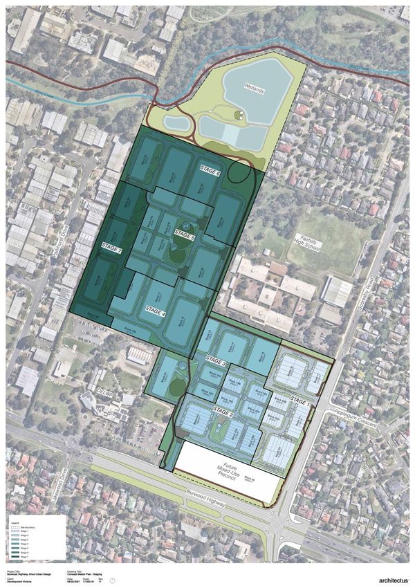
TABLE OF CONTENTS:

1.    INTRODUCTION .......................................................................................................... 10
1.1 STAGE 1 – 7 DEVELOPMENT AREA ................................................................................... 10
1.1.1 Limitations ................................................................................................................ 11
FIGURE 1.           PROPERTY LOCATION (COURTESY OF ARCHITECTUS PTY LTD) .......... 13
2.    METHODOLOGY ......................................................................................................... 14
2.1 FIELD SURVEYS ............................................................................................................. 15
2.1.1 Native vegetation assessment .................................................................................. 16
2.1.2 Native canopy trees.................................................................................................. 18
2.1.3 General flora and fauna survey................................................................................. 19
2.1.4 Likelihood of occurrence ........................................................................................... 20
3.    RESULTS..................................................................................................................... 22
3.1 NATIVE VEGETATION AND HABITAT ................................................................................... 22
3.1.1 Pre-disturbance EVCs .............................................................................................. 23
FIGURE 2.           DELWP 2005 EVC MODELLING (DELWP 2020) .......................................... 23
3.1.2 Intact native vegetation patches................................................................................ 24
3.1.3 Intact native canopy trees ......................................................................................... 25
FIGURE 3.           INDICATIVE SITE CONDITION PHOTOGRAPHS......................................... 33
3.2    SIGNIFICANT FLORA ....................................................................................................... 35
3.3    SIGNIFICANT FAUNA ....................................................................................................... 36
4.    POTENTIAL IMPACTS ................................................................................................ 38
4.1 IMPACTS ON NATIVE VEGETATION AND HABITAT ................................................................. 38
4.2 SIGNIFICANT FLORA AND FAUNA IMPACTS ......................................................................... 39
4.3 URBANISATION AND CONSTRUCTION PHASE IMPACTS......................................................... 39
4.3.1 Weed invasion and disease ...................................................................................... 40
4.3.2 Erosion, sedimentation, and water pollutants ............................................................ 40
4.3.3 Ecological light pollution ........................................................................................... 40
4.3.4 Stormwater surface flows ......................................................................................... 41
5.    IMPACT MITIGATION .................................................................................................. 42
5.1 PRELIMINARY MEASURES TO AVOID AND MINIMISE IMPACTS ................................................ 42
5.2 GENERAL IMPACT MITIGATION MEASURES......................................................................... 43
5.2.1 Native tree and vegetation retention ......................................................................... 44
5.2.2 Minimising damage to trees ...................................................................................... 45
5.2.3 Vegetation retention and protection .......................................................................... 45
5.2.4 Weed and soil pathogen control................................................................................ 46
5.2.5 Erosion control ......................................................................................................... 46
5.2.6 Light pollution ........................................................................................................... 47
5.2.7 Stormwater, and protection of wetland habitats ......................................................... 47
6.    LEGISLATIVE AND POLICY IMPLICATIONS.............................................................. 50
6.1 ENVIRONMENTAL PROTECTION AND BIODIVERSITY CONSERVATION ACT ............................. 50
6.2 FLORA AND FAUNA GUARANTEE ACT ............................................................................... 55
6.2.1 FFG Act legislative implications ................................................................................ 55
6.3 PLANNING AND ENVIRONMENT ACT 1987 (VIC) ................................................................ 55
6.3.1 Guidelines for the Removal, Destruction or Lopping of Native Vegetation ................. 55
6.3.2 Native vegetation clearance legislative and policy implications.................................. 57
6.3.3 Native vegetation avoid and minimise statement....................................................... 58

                                Ecological Assessment: Stage 1 - 7 Development Area 609-619 & 621 Burwood Highway, Knoxfield
                                                                                      ECOCENTRIC Environmental Consulting
                                                                                                                     page i
6.4 CATCHMENT AND LAND PROTECTION ACT ........................................................................ 59
6.5 ENVIRONMENT EFFECTS ACT ......................................................................................... 60
6.6 WILDLIFE ACT ............................................................................................................... 62
6.6.1 Wildlife Regulations 2014 ......................................................................................... 62
7.    CONCLUSION ............................................................................................................. 64
8.    REFERENCES ............................................................................................................. 66
9.    APPENDICES .............................................................................................................. 68
9.1    FLORA RECORDED ON THE PROPERTY ............................................................................. 68
9.1    FAUNA RECORDED ON THE PROPERTY ............................................................................. 72
9.2    SIGNIFICANT FLORA RECORDED WITHIN 5 KM (OR PREDICTED TO OCCUR) ........................... 74
9.3    SIGNIFICANT FAUNA RECORDED WITHIN 5 KM (OR PREDICTED TO OCCUR) ......................... 75
9.4    ENSYM OFFSET REPORT................................................................................................ 76
9.5    MAPS........................................................................................................................... 84

LIST OF FIGURES:

Figure 1.       Property location (courtesy of Architectus Pty Ltd) ............................................. 13
Figure 2.       DELWP 2005 EVC modelling (DELWP 2020) .................................................... 23
Figure 3.       Indicative site condition photographs ................................................................. 33

LIST OF TABLES:

Table 1.        Habitat significance ........................................................................................... 16
Table 2.        Vegetation categories. ....................................................................................... 18
Table 3.        Likelihood of occurrence criteria ........................................................................ 21
Table 4.        Native vegetation patch VQA results ................................................................. 25
Table 5.        Native canopy trees to be removed or considered lost within the Stage 1 – 7
                 development area. ........................................................................................... 26
Table 6.        Native canopy trees to be retained during development of Stage 1 – 7 .............. 29
Table 7.        GIS metadata: native vegetation full loss ........................................................... 39
Table 8.        EPBC Act Significant Impact Criteria – Swift Parrot ........................................... 51
Table 9.        EPBC Act Significant Impact Criteria – Grey-headed Flying-fox ......................... 53
Table 10.       Determining assessment pathway ..................................................................... 57
Table 11.       Vegetation clearance and offset requirements ................................................... 57
Table 12.       Noxious weeds recorded at the development area............................................. 60
Table 13.       Summary of legislative and associated policy requirements ............................... 65

                                Ecological Assessment: Stage 1 - 7 Development Area 609-619 & 621 Burwood Highway, Knoxfield
                                                                                      ECOCENTRIC Environmental Consulting
                                                                                                                     page ii

Acknowledgements
 Ecocentric acknowledges the following pers ons , agenc ies and com panies for their c ontributions
 to this study and report:
      •    Development Vic toria: J essica Smooker, Peter Hood, Emma Arkesteijn, Tina Blackam
           & Alana Goldberg
      •   Engeny Water Managem ent: Glenn Ottrey
      •   Collie Town Planners: Michael Collie
      •   Paroissien Grant and Ass ociates Pty Ltd: Jarrod Wilson, Nigel Paroissien & William
          McMahon
      •   MDG Landscape Architects: Andrew Moyle & Courtney Mitten
      •   Architectus: Gabriel J ens en, Dean Thornton & Lauren Clerey
      •   One Mile G rid: Ross Hill & Julian Stone
      •   Shepherd Ecologic al: M ark Shepherd
      •   Karl Just
      •   TactEc ol: J ake Urlus
      •   WSP: Allan Richards on

ACRONYMS
BoM                                Bureau of Meteorology

CaLP Act 1994 (Vic)                Victorian Catchment and Land Protection Act 1994

Cwlth                              Commonwealth

DAWE                               Federal Department of Agriculture, Water and the

                                   Environment (formerly DoEE)

DELWP                              Victorian Department of Environment, Land, Water

                                   and Planning (formerly DEPI)

EPBC Act 1999 (Cwlth)              Commonwealth Environment Protection and Biodiversity

                                   Conservation Act 1999

FFG Act 1988 (Vic)                 Victorian Flora and Fauna Guarantee Act 1988

GIS                                Geographical Information System (mapping system)

MNES                               Matter of National Environmental Significance

PPWCMA                             Port Phillip and Westernport Catchment Management

                                   Authority

VBA                                DELWP’s Victorian Biodiversity Atlas

Wildlife Act 1975 (Vic)            Victorian Wildlife Act 1975

                          Ecological Assessment: Stage 1 - 7 Development Area 609-619 & 621 Burwood Highway, Knoxfield
                                                                                ECOCENTRIC Environmental Consulting
                                                                                                              page iv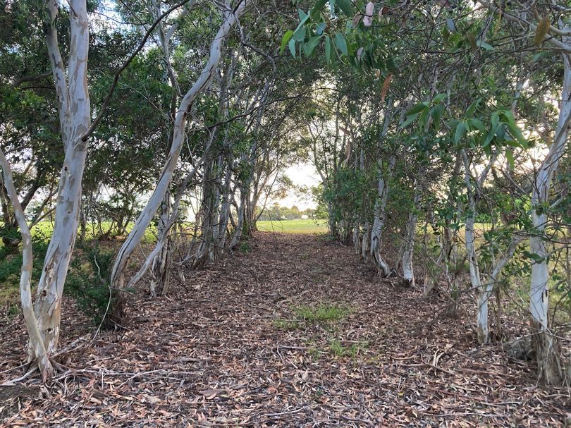
SPECIES SIGNIFICANCE
Significant threatened species are defined as taxa listed under:

    •   The EPBC Act 1999 (Cwlth);

    •   The FFG Act 1988 (Vic);

    •   DELWP’s Advisory List of Rare or Threatened Plants in Victoria, either as
        ‘endangered’, ‘vulnerable’, or ‘rare’ (but not those included under the ‘poorly
        known’ category);

    •   DELWP’s Advisory List of Threatened Vertebrate Fauna in Victoria, either as
        ‘critically endangered’, ‘endangered’ or ‘vulnerable’ (but not those included
        under the ‘near threatened’ or ‘data deficient’ categories); and/or

    •   DELWP’s Advisory List of Threatened Invertebrate Fauna in Victoria, either as
        ‘critically endangered’, ‘endangered’ or ‘vulnerable’ (but not those included
        under the ‘near threatened’ or ‘data deficient’ categories).

    •

NATIVE VEGETATION
The Victorian Planning Provisions identify native vegetation as flora species that are
native to Victoria. This includes species that are indigenous to the project’s location
and the region, as well as species that may be found further afield but within the state of
Victoria. Native vegetation is defined under the Guidelines 2017 policy (DELWP 2017)
as follows:

A patch of native vegetation is:

        •   an area of vegetation where at least 25 per cent of the total perennial
            understorey plant cover is native, or

        •   any area with three or more native canopy trees where the drip line of each
            tree touches the drip line of at least one other tree, forming a continuous
            canopy, or

        •   any mapped wetland included in the ‘Current wetlands map’, available in
            DELWP systems and on-line GIS mapping layers (DELWP 2017).

A large or small scattered tree is a native species that is found in the canopy strata,
that is greater than 3m in height, and that does not form part of a remnant patch.
Scattered trees have two sizes, small and large:

        •   a small scattered tree is less than the large tree benchmark for the species
            in the relevant EVC;

        •   a large tree is equal to or greater than the large tree benchmark for the
            species in the relevant EVC;

        •   a standing dead tree that does not form part of a patch is treated as a large
            scattered tree if it has a trunk diameter of 40 centimetres or more at a
            height of 1.3 metres above the ground (DELWP 2017).

A large canopy tree is a native species that is found in the canopy strata, that is
greater than 3m in height AND greater than or equal to the appropriate EVC benchmark
DBH for a large tree, and which is found within a patch of native vegetation (as defined
above).

                       Ecological Assessment: Stage 1 - 7 Development Area 609-619 & 621 Burwood Highway, Knoxfield
                                                                             ECOCENTRIC Environmental Consulting
                                                                                                            page v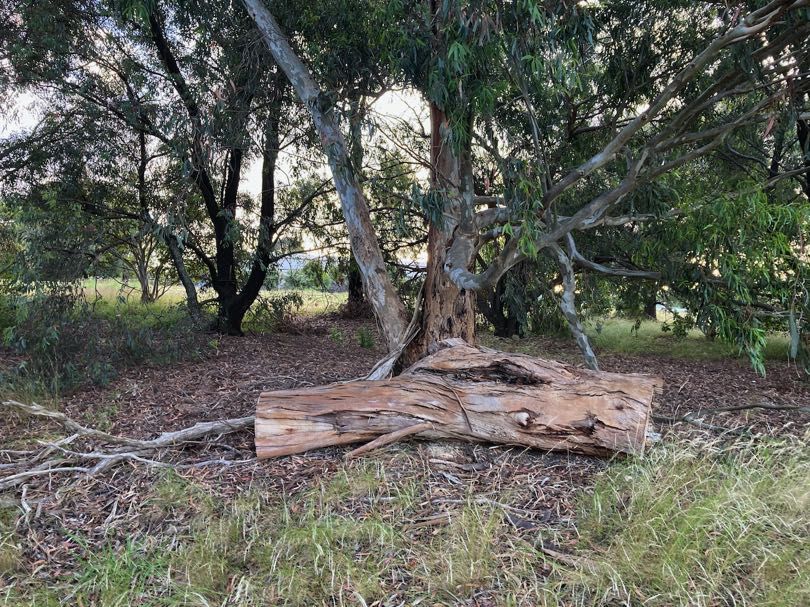
The current Guidelines 2017 policy recognises that large trees are often the oldest part
of an ecological system and are difficult to replace in the short term. The loss of large
trees (native trees that would be found in the canopy of respective EVC with a DBH that
is greater than the benchmark DBH) must be Offset with an equivalent number of large
trees in order to ensure there is no net loss of biodiversity value associated with
clearing.

                      Ecological Assessment: Stage 1 - 7 Development Area 609-619 & 621 Burwood Highway, Knoxfield
                                                                            ECOCENTRIC Environmental Consulting
                                                                                                          page vi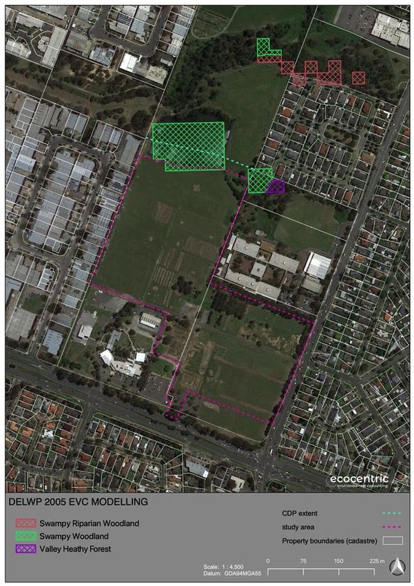
GLOSSARY

TERM                                     DEFINITION

Bioregion                                Biogeographical areas that capture the patterns of ecological characteristics in
                                         the landscape or seascape, providing a natural framework for recognising and
                                         responding to biodiversity values.

Bioregional Conservation Status (BCS     A state-wide classification of the degree of depletion in the extent and/or quality
of an EVC)                               of an Ecological Conservation Class (EVC) within a bioregion in comparison to
                                         the State’s estimation of its pre-1750 extent and condition.

Canopy tree                              See ‘Native Canopy Tree’.

Diameter at Breast Height (DBH)          The diameter of the trunk of a tree measured over bark at 1.3m above ground
                                         level.

Drip Line                                The outermost boundary of a tree canopy (leaves and/or branches) where the
                                         water drips onto the ground.

Ecological Vegetation Class (EVC)        A type of native vegetation classification that is described through a combination
                                         of its floristic, life form and ecological characteristics, and through an inferred
                                         fidelity to particular environmental attributes. Each EVC includes a collection of
                                         floristic communities (i.e. lower level in the classification that is based solely on
                                         groups of the same species) that occur across a biogeographical range, and
                                         although differing in species, have similar habitat and ecological processes
                                         operating.

EVC Benchmark                            A standard vegetation quality reference point relevant to the vegetation type that
                                         is applied in habitat hectare assessments. Represents the average
                                         characteristics of a mature and apparently long-undisturbed state of the same
                                         vegetation type.

General Offset                           A General Offset is required when the removal of native vegetation does not
                                         have a significant impact on any habitat for rare or threatened species.

General Habitat Unit                     A General Habitat Unit is a measure of loss (and Gain in an Offset Site) in overall
                                         biodiversity value of native vegetation (both patch and scattered tree).

General Habitat Unit Offset target       A General Habitat Unit Offset target is that quantity of General Habitat Units that
                                         are to be secured to ensure that there is ‘no net loss’ in biodiversity value
                                         associated with the clearance of native vegetation (both patch or scattered tree).
                                         The General Habitat Units secured for an Offset target must meet the following
                                         attribute requirements:
                                         •     Minimum strategic biodiversity value score: the strategic biodiversity value
                                               score of the Offset Credits must be at least 80 per cent of the strategic
                                               biodiversity value score of the native vegetation to be removed;
                                         •     Vicinity: the offset must be located within the same Catchment
                                               Management Authority boundary or municipal district as the native
                                               vegetation to be removed.

Habitat Hectare                          A site-based measure of quality and quantity of native vegetation that is
                                         assessed in the context of the relevant native vegetation type.

Habitat score                            The score assigned to a Habitat Zone that indicates the quality of the vegetation
                                         relative to the EVC benchmark – sum of the site condition score and landscape
                                         context score usually expressed as a percentage or as a decimal fraction of 1.

Habitat Zone                             A discrete area of native vegetation consisting of a single vegetation type (EVC)
                                         with an assumed similar quality. This is the base spatial unit for conducting a
                                         habitat hectare assessment.

High threat weed                         Introduced plant species (including non-indigenous ‘natives’) with the ability to
                                         out-compete and substantially reduce one or more indigenous life forms in the
                                         longer term, assuming on going current site characteristics and disturbance
                                         regime.

                           Ecological Assessment: Stage 1 - 7 Development Area 609-619 & 621 Burwood Highway, Knoxfield
                                                                                 ECOCENTRIC Environmental Consulting
                                                                                                               page vii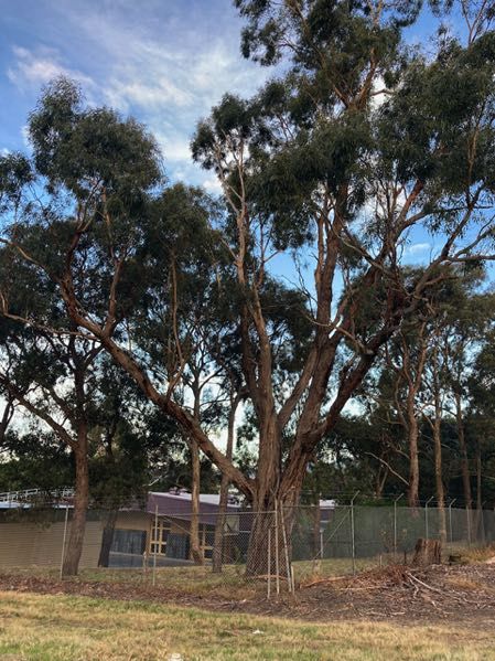
TERM                                       DEFINITION

Location Category                          There are three location categories that indicate the potential risk to biodiversity
                                           from removing a small amount of native vegetation. These location categories
                                           are identified by DELWP as follows:
                                           •   Location 3 – includes locations where the removal of less than 0.5 hectares
                                               of native vegetation could have a significant impact on habitat for a rare or
                                               threatened species.
                                           •   Location 2 – includes locations that are mapped as endangered EVCs
                                               and/or sensitive wetlands and coastal areas and are not included in Location
                                               3.
                                           •   Location 1 – includes all remaining locations in Victoria.

Mapped wetlands                            Mapped wetlands may or may not be visible on the ground and are treated as a
                                           patch of native vegetation for the purpose of Offsets unless they are covered by
                                           a hardened, man-made surface, for example, a roadway.
                                           The location and extent of mapped wetlands are available in NVIM and other
                                           DELWP GIS mapping systems.

Matters of national Environmental          There are nine MNES identified under the EPBC Act 1999 (Cwlth): World
Significance (MNES)                        Heritage properties; National Heritage places; wetlands of international
                                           importance (listed under the Ramsar Convention); listed threatened species and
                                           ecological communities; migratory species protected under international
                                           agreements (protected under international agreements); Commonwealth marine
                                           areas, the Great Barrier Reef Marine Park; nuclear actions (including uranium
                                           mines); and water resources in relation to coal seam gas development and large
                                           coal mining development.

Native Canopy Tree                         A native canopy tree is either:
                                           •   a mature tree (able to flower) that is greater than three metres in height and
                                               is normally found in the upper layer of the relevant vegetation type (EVC); or
                                           •   a standing dead tree (stag) if it has a trunk diameter of 40 centimetres or
                                               more at a height of 1.3 metres above the ground.

Native Vegetation                          Native vegetation is defined in the Victoria Planning Provisions as ‘plants that are
                                           indigenous to Victoria, including trees, shrubs, herbs and grasses’.

No Net Loss                                An outcome where a particular gain in the contribution to Victoria’s biodiversity is
                                           equivalent to an associated loss in the contribution to Victoria’s biodiversity from
                                           permitted clearing.

Offset                                     Protection and management (including revegetation) of native vegetation at a
                                           site to generate a gain in the contribution that native vegetation makes to
                                           Victoria’s biodiversity. An Offset is used to compensate for the loss to Victoria’s
                                           biodiversity from the removal of native vegetation. Offsets are to be secured in
                                           perpetuity with an on-Title conservation covenant.

Offset target                              The amount of Offset required, measured in Habitat Units, to ensure permitted
                                           clearing of native vegetation results in no net loss in the contribution made by
                                           native vegetation to Victoria’s biodiversity.

Protection (of a tree)                     An area with twice the canopy diameter of the tree(s) fenced and protected from
                                           adverse impacts: grazing, burning and soil disturbance not permitted, fallen
                                           timber retained, weeds controlled, and other intervention and/or management if
                                           necessary, to ensure adequate natural regeneration or planting can occur.

Recruitment                                The production of new generations of plants, either by allowing natural ecological
                                           processes to occur (regeneration etc.), by facilitating such processes, or by
                                           actively revegetating (replanting, reseeding). See revegetation.

Patch of native vegetation                 A patch of native vegetation is either:
                                           •   an area of vegetation where at least 25 per cent of the total perennial
                                               understorey plant cover is native; or
                                           •   any area with three or more native canopy trees where the drip line of each
                                               tree touches the drip line of at least one other tree, forming a continuous
                                               canopy; or
                                           •   any mapped wetland included in the current wetlands layer available in
                                               NVIM and other DELWP systems.

                             Ecological Assessment: Stage 1 - 7 Development Area 609-619 & 621 Burwood Highway, Knoxfield
                                                                                   ECOCENTRIC Environmental Consulting
                                                                                                                 page viii
TERM                                     DEFINITION

Perennial Understorey                    Plants that usually live for more than two years and are found in the lower layers
                                         of vegetation, like grasses and shrubs.

Plant cover                              The proportion of the ground that is shaded by vegetation foliage when lit from
                                         directly above.

Revegetation                             Establishment of native vegetation to a minimum standard in formerly cleared
                                         areas, outside of a remnant patch.

Scattered trees                          A scattered tree is a native canopy tree (see ‘Native Canopy Tree’ above) that
                                         does not form part of a patch.
                                         Scattered trees have two sizes, small and large:
                                         •   a small scattered tree is less than the large tree benchmark for the species
                                             in the relevant EVC;
                                         •   a large tree is equal to or greater than the large tree benchmark for the
                                             species in the relevant EVC;
                                         •   a standing dead tree that does not form part of a patch is treated as a large
                                             scattered tree if it has a trunk diameter of 40 centimetres or more at a height
                                             of 1.3 metres above the ground.

Species – General Offset Test            The species-general offset test measures the proportional impact from the
                                         removal of native vegetation on the habitat of rare or threatened species,
                                         according to the Habitat importance maps, and compares this to the species
                                         offset threshold.

Species Habitat Unit                     A Species Habitat Unit is a measure of loss (and Gain in an Offset Site) in
                                         biodiversity value of native vegetation (both patch and scattered tree) for a
                                         particular rare or threatened species.

Species Habitat Unit Offset target       A Species Habitat Unit Offset is required when the removal of native vegetation
                                         has a significant impact on habitat for a rare or threatened species. Species
                                         Offsets must compensate for the removal of that particular species’ habitat.

Strategic Biodiversity Value (SBV)       The Strategic Biodiversity Value is a rank of a location’s complementary
                                         contribution to Victoria’s biodiversity, relative to other locations across the state
                                         with regard to its condition, extent, connectivity and the support function it plays
                                         for species.

Tree Protection Zone (TPZ)               Calculated area (based on AS 4970-2009 (Protection of trees on development
                                         sites)) of soil volume required to encompass sufficient absorbing tree root
                                         systems to ensure the long-term survival of a tree. Trees may be considered as
                                         lost (and may require an Offset) if impacts of greater than 10% intrusion into the
                                         TPZ occur.

Wetlands                                 See ‘Mapped wetlands’.

                           Ecological Assessment: Stage 1 - 7 Development Area 609-619 & 621 Burwood Highway, Knoxfield
                                                                                 ECOCENTRIC Environmental Consulting
                                                                                                               page ix
1. INTRODUCTION
Ecocentric Environmental Consulting (hereafter referred to as Ecocentric) was
engaged by Development Victoria in December 2014 to undertake preliminary
ecological assessments at two properties; 609-619 and 621 Burwood Highway,
Knoxfield, Victoria (SPI: 2258\PP3478 and 1\TP152947). Further detailed
assessments including targeted survey for threatened fauna were undertaken in
2016/2017, and again in order to inform this report in 2020.
The proposed development area consists of the entire 621 Burwood Highway
parcel, and a subset of the 609-619 Burwood Highway parcel, hereafter
collectively referred to as the development area (see Map 1 in Appendix 9.8).
The development area is to be developed predominantly for residential
purposes, in accordance with the C160 planning scheme amendment under the
Planning and Environment Act 1987 (Vic), and includes the establishment of a
wetland and Water Sensitive Urban Design (WSUD) stormwater treatment
system in the northern sector of the property.
This report identifies ecological values and unavoidable impacts within the
portion of the subdivision area that is identified as Stage 1 to 7 (see Figure 1 for
details) and excluding an existing dam. The remainder of the property,
generally described as the wetlands area (including the existing dam), is
assessed in an accompanying report (Ecocentric in preparation). Similarly, a
sales information centre, driveway and carparking will be developed within the
southeastern corner of the property; these works are also assessed in an
accompanying report (Ecocentric in preparation).
The objectives of the project were to:
• Document the ecological values of the site, including:
o Significant flora and fauna species, and areas supporting potential
habitat for them; and
o Native vegetation, including ‘remnant patches’ and ‘scattered trees’.
• Map these ecological values and identify their quality and extent;
• Identify potential impacts to these ecological values from the proposed
development, including implications under relevant legislation and
policies; and
• Outline appropriate measures to avoid, mitigate or offset potential
impacts.
1.1 STAGE 1 – 7 DEVELOPMENT AREA
The broader development area adjoins an industrial estate to the west, Burwood
Highway and commercial / office development to the south, Scoresby Road and
Fairhills High School / residential development to the east, and the Blind Creek
corridor and its associated recreation trail to the north. The topography of the
development area slopes gently from the highest elevations in the southern
sector of the site (at ~97 m above sea level (ASL)) to the lowest elevations (~77
m ASL) in the northern sector of the site.
Ecological Assessment: Stage 1 - 7 Development Area 609-619 & 621 Burwood Highway, Knoxfield
ECOCENTRIC Environmental Consulting
page 10The northern sector of the site is situated on a floodplain formation that includes
a constructed dam which also functions as a minor flood retarding basin. The
floodplain area and northern quadrant of the property, hereafter referred to as
the wetlands area, is generally described as land north of the area being
developed as a Comprehensive Development Zone (CDZ). The wetlands area,
including an existing dam drainage swale are subject to a separate biodiversity
assessment being undertaken by Ecocentric (2021 in preparation), and
assessment of that area is therefore not included in this report (see also Figure
1 below for an indication of the area covered by this report).
The development of the total property will be subject to a number of Permit
applications. Three Permit applications are being lodged at this time, namely:
• Access to Scoresby Road and the removal of some vegetation within the
Future Mixed-use Precinct development area;
• Subdivision of Stages 1 and 2 within the Stage 1 – 7 development area;
and,
• Development of wetland habitat and Water Sensitive Urban Design
(WSUD) stormwater treatment systems within the Wetlands area (see
also Figure 1 below for details).
The majority of the Stage 1 – 7 development area comprises cleared land south
of the CDZ, and includes planted rows of exotic trees and planted native and
non-native trees and shrubs. Some remnant indigenous trees and vegetation
exists on site, and there are additionally trees planted at the property
boundaries and within gardenbeds which are native to Victoria and that meet the
definition of native vegetation under Clause 52.17 of the Knox Planning
Scheme.
The majority of the development area is currently zoned Comprehensive
Development Zone (CDZ2), and there are no overlays that apply to the Stage 1
– 7 development area.
1.1.1 Limitations
The targeted surveys were carried out during suitable conditions for the
detection of the target species. While it is possible that some threatened
vertebrate fauna species not recorded during the current surveys may
occasionally visit or occur within the site, it is unlikely that any of these
additional species regularly occur on, or rely upon, the site.
Please also note that surveys were not limited to the target species at the time
of assessment; rather, all flora and fauna taxa observed on site were recorded
and assessed for their habitat requirements, capacity to be found within the
development area, and their conservation significance.
No targeted surveys for significant flora were conducted. Site assessments
were undertaken utilising the ‘random meander’ process of undertaking
assessment of suitable sites whilst selectively traversing preferred habitat for
threatened species (see Section 2.1). Ecocentric is confident that this survey
methodology meets the objectives of the project brief and criteria, and standards
as set out in the Vegetation Quality Assessment Manual (DSE 2004; also
commonly referred to as a Habitat Hectare Assessment).
Ecological Assessment: Stage 1 - 7 Development Area 609-619 & 621 Burwood Highway, Knoxfield
ECOCENTRIC Environmental Consulting
page 11This report does not consider development implications that relate to non-
environmental zoning and overlays; including objectives set out in the CDZ and
its Schedule 2. Similarly, this report does not consider development
implications which may apply to the property under the Aboriginal Heritage Act
2006 (Vic).
This report relies on contributions from several consultancies and information
provided by Development Victoria. Findings contained herein are therefore
based on the reports provided at the date of publication; Ecocentric will not be
held accountable for post-publication variations associated with report updates
from external consultancies, agencies or parties.
This report assumes that the reader is familiar with the proposed development
and its objectives, and the planning and financing context that brought about its
instigation.
Ecological Assessment: Stage 1 - 7 Development Area 609-619 & 621 Burwood Highway, Knoxfield
ECOCENTRIC Environmental Consulting
page 12Figure 1. Property location (courtesy of Architectus Pty Ltd)
Ecological Assessment: Stage 1 - 7 Development Area 609-619 & 621 Burwood Highway, Knoxfield
ECOCENTRIC Environmental Consulting
page 132. METHODOLOGY
A desktop review was undertaken as the first component of this project. This
involved a review of on-line data resources available from relevant Victorian and
Commonwealth departments, and a review of available management reports and
documentation from other sites within the region. Maps of the site’s indicative
pre-1750 Ecological Vegetation Classes (EVCs), likely patches of remnant
EVCs, and a map of the bioregion were generated on-line and were referred to
on site during the assessment. An aerial photograph of the site was generated
from NearMap and overlaid with the Title boundary data.
Existing datasets, modelling and mapping for the site that were reviewed and
interrogated consisted of the following:
• Biodiversity Interactive Maps classifying (but not limited to) extant and
pre-disturbance EVCs, Bioregion, Location Risk and Strategic
Biodiversity Values (SBV) within the property and surrounds (DELWP
2020 1; Victorian Open Data Directory 2020 2);
• EVC benchmarks (DELWP 2020 3);
• Victorian Biodiversity Atlas on-line database for records of significant
flora and fauna in the region (DELWP 2020 4);
• The Atlas of Living Australia on-line database for records of significant
flora and fauna in the region (ALA 2020 5);
• Commonwealth Department of Agriculture, Water and the Environment
(DAWE) EPBC Act Protected Matters Search Tool database for
significant flora, fauna and vegetation communities in the region (DAWE
2020 6);
• DELWP species distribution and habitat importance models as produced
for the Guidelines 2017 policy (GIS mapping layers from Victorian Open
Data Directory 2020 7; DELWP 2017);
• Aerial imagery to determine habitat extents and linkages (NearMap
2020 8);
• Relevant legislation, government policy and strategies (DELWP 2020 9);
and
• Publicly available geospatial datasets (including BirdData and
iNaturalist).
1
http://maps.biodiversity.vic.gov.au/viewer/?viewer=NatureKit
2
https://www.data.vic.gov.au
3
https://www.environment.vic.gov.au/biodiversity/bioregions-and-evc-benchmarks
4
https://vba.dse.vic.gov.au/vba/
5
https://spatial.ala.org.au
6
http://www.environment.gov.au/epbc/pmst/index.html
7
https://www.data.vic.gov.au
8
http://maps.nearmap.com
9
http://planningschemes.dpcd.vic.gov.au
Ecological Assessment: Stage 1 - 7 Development Area 609-619 & 621 Burwood Highway, Knoxfield
ECOCENTRIC Environmental Consulting
page 14Independent assessments were also commissioned by Development Victoria for
the purpose of informing the Planning Permit application, these include:
• Development Master Plan by Architectus Pty Ltd (Architectus 2021;
hereafter referred to as the Development Master Plan).
• Arborist report conducted by Galbraith and Associates Pty Ltd (Galbraith
2020; hereafter referred to as the Arborist Assessment report).
• Landscape Master Plan by MDG Landscape Architects (MDG 2021;
hereafter referred to as the Landscape Plan).
Ecocentric has also conducted ecological assessments across the broader
property in support of Permit applications for the Stage 1 – 7 Development Area
and the Sales Centre Development Area. Findings and recommendations are
reported in the following documents (in preparation at time of publication):
• Ecological Assessment: Wetland Development Area 609-619 & 621
Burwood Highway, Knoxfield (Ecocentric 2021 in preparation).
• Ecological Assessment: Sales Centre Development Area 609-619 & 621
Burwood Highway, Knoxfield (Ecocentric 2021 in preparation).
These reports and the data behind them have been used by Ecocentric to inform
this assessment.
2.1 FIELD SURVEYS
Ecological values on the property were assessed during several studies in 2015,
2017 and 2020 by suitably qualified and experienced ecologists. Ecocentric
staff hold accreditation in the Vegetation Quality Assessment Competency
Check; the company is also a DELWP Accredited Organisation for the
assessment and establishment of Offset Sites, and a registered over-the-
counter Native Vegetation Offset Broker.
The following techniques were utilised during the field surveys:
• All areas of native vegetation (see Section 2.1.1) and habitat (see
Section 2.1.3) were assessed across the property;
• Mapped and extant Ecological Vegetation Classes (EVCs) on site were
verified and assessed in the field to a hand-held tablet running Quantum
GIS;
• Remnant habitat areas were assessed for habitat quality and
conservation significance against relevant EVC benchmarks and in
accordance with DELWP approved methodologies (see Section 2.1.1 for
details). Where appropriate, habitat areas were also assessed against
impact threshold criteria as documented under the EPBC Act for
threatened vegetation communities (available on the Species Profile and
Threats Database);
• Random meander searches for threatened flora and fauna species were
completed throughout the property (see Section 2.1.3); and
• Any other incidental discussions, observations or evidence of flora or
fauna were recorded.
Ecological Assessment: Stage 1 - 7 Development Area 609-619 & 621 Burwood Highway, Knoxfield
ECOCENTRIC Environmental Consulting
page 15Habitat values and quality were assessed based on significance criteria as
detailed below in Table 1.
Table 1. Habitat significance
Habitat significance DESCRIPTION
category
Very high significance Site known to support long-term breeding population(s) of
threatened flora or fauna; is contiguous with large areas (greater
than 50ha) of remnant vegetation and habitat; and there is a very
high cover (greater than 75%) of remnant, indigenous vegetation
with EVC appropriate canopy structures intact.
High significance Site provides optimal habitat conditions for rare or threatened flora
or fauna; there is a high degree of connectivity to large areas
(greater than 50ha) of remnant vegetation and habitat; and there is a
good cover (greater than 50%) of remnant, indigenous vegetation
with EVC appropriate canopy structures intact.
Medium significance Site provides sub-optimal habitat conditions for rare or threatened
flora or fauna; there is connectivity to areas (greater than 0.4ha) of
remnant vegetation and habitat; and there is some cover (greater
than 25%) of remnant, indigenous vegetation with EVC appropriate
canopy structures intact.
Low significance Site provides limited habitat conditions for flora or fauna, and there
is some cover of remnant, indigenous vegetation on site.
The precautionary approach was adopted for all site surveys where
discretionary decisions were made. In particular, the absence of evidence of
threatened flora, fauna, vegetation communities or habitat values during surveys
was not interpreted as evidence of their absence on site.
2.1.1 Native vegetation assessment
A native vegetation assessment was undertaken to determine the extent and
quality of native vegetation present at the site, and to inform potential Offset
requirements if native vegetation clearance is approved.
Ecological Vegetation Classes were determined based on EVC modelling and
benchmarks (DELWP 2017), and as confirmed in the field during the site
surveys. Vegetation Quality Assessments (VQA; also commonly referred to as a
Habitat Hectare Assessment) were undertaken for all areas of native vegetation
(both remnant and as scattered trees) in accordance with the Vegetation Quality
Assessment Manual – Guidelines for applying the habitat hectare scoring
method (DSE 2004).
Native vegetation is defined under the Native Vegetation Permitted Clearing
Regulations as follows:
A patch of native vegetation is:
• an area of vegetation where at least 25 per cent of the total perennial
understorey plant cover is native, or
• any area with three or more native canopy trees where the drip line of
each tree touches the drip line of at least one other tree, forming a
continuous canopy, or
Ecological Assessment: Stage 1 - 7 Development Area 609-619 & 621 Burwood Highway, Knoxfield
ECOCENTRIC Environmental Consulting
page 16• any mapped wetland included in the ‘Current Wetlands map’, available in
DELWP systems and tools.
A scattered tree is a native canopy tree that does not form part of a
remnant patch. Scattered trees are classified into two different sizes, small
and large:
• a small scattered tree is less than the large tree benchmark for the
species in the relevant EVC;
• a large tree is equal to or greater than the large tree benchmark for the
species in the relevant EVC;
• a standing dead tree that does not form part of a patch is treated as a
large scattered tree if it has a trunk diameter of 40 centimetres or more at
a height of 1.3 metres above the ground (DELWP 2017).
The current Guidelines 2017 policy recognises that large trees are often the
oldest part of an ecological system and are difficult to replace in the short term.
To address this and to ensure the protection of large trees in the landscape,
when large trees are approved to be removed, the secured Offset must include
large trees. A large tree to be secured as an Offset may be either scattered or
within a patch.
Native vegetation is further described in the Planning Scheme as flora native to
Victoria which, in some cases, includes taxa that are not indigenous to the site.
Table 2 below identifies vegetation types assessed in this study.
Ecological Assessment: Stage 1 - 7 Development Area 609-619 & 621 Burwood Highway, Knoxfield
ECOCENTRIC Environmental Consulting
page 17Table 2. Vegetation categories.
VEGETATION DESCRIPTION PLANNING IMPLICATIONS
CATEGORY
Site indigenous Indigenous to a local area. Defined as There are certain exemptions under all
‘taxa that have originated in a given area Victorian Planning Schemes. ‘Planted
without human involvement or that have vegetation’ provides an exemption to
arrived there without intentional or Clause 52.17 for native vegetation that
unintentional intervention of humans has been planted on site whereby:
from an area in which they are native’. Native vegetation that is to be
removed, destroyed or lopped that
was either planted or grown as a
result of direct seeding.
This exemption does not apply to
native vegetation planted or
managed with public funding for the
purpose of land protection or
enhancing biodiversity unless the
removal, destruction or lopping of
the native vegetation is in
accordance with written permission
of the agency (or its successor)
that provided the funding.
Much of the native vegetation at this site
has been planted for aesthetic purposes
at the property boundaries, as evidenced
by the ornamental garden-beds and
linear nature of the vegetation. It is
assumed in this instance however that
public funds have been used, and this
exemption is therefore not applied.
Native to Victoria Non-indigenous to the local area but If vegetation is not exempt as above, it
native to Victoria (such as Tasmanian may require a permit for removal.
Blue Gum, Spotted Gum and Giant The Schedule to the Knox Planning
Honey-myrtle). Scheme Section 52.17 further lists
Defined in Victorian Planning Provisions species that are considered by the
– Definitions – Clause 72 as ‘Plants that municipality to be environmental weeds
are indigenous to Victoria, including (and native to Victoria) and which are
trees, shrubs, herbs, and grasses’. therefore also exempted under the
Clause.
Native to Australia Non-indigenous Australian native plants Usually do not require a permit for
or vegetation which are not indigenous removal but are identified to demonstrate
to Victoria (such as Sugar Gums). that these plants have not been
overlooked.
Exotic Vegetation Planted exotic vegetation, which is flora Usually does not require a permit for
species that are not native to Australia. removal, unless the vegetation is
covered by an ‘Environment
Significance’ or ‘Vegetation Protection’
Overlay that specifically addresses
exotic vegetation.
2.1.2 Native canopy trees
The project arboricultural consultant mapped the location, species, DBH and
TPZ of all canopy trees and non-canopy trees (tree and shrub species that form
a secondary canopy layer) to the property feature survey; further details are
provided in the Arborist Assessment report. The TPZ for each tree was then
processed by the project landscape architect and imported to the Ecocentric
Ecological Assessment: Stage 1 - 7 Development Area 609-619 & 621 Burwood Highway, Knoxfield
ECOCENTRIC Environmental Consulting
page 18GIS for analysis on site; further details are provided in the Landscape Plan for
the project.
The tree data and GIS mapping layer were used by Ecocentric to identify all
trees on site that are identified as being native to Victoria. These trees were
then classified during the site assessments as being scattered or as part of a
patch based on the number of trees and canopy spread.
The Assessor’s Handbook: Applications to Remove, Destroy or Lop Native
Vegetation (DELWP 2017; hereafter referred to as the Handbook 2017) defines
a canopy tree as a mature tree (able to flower) that is greater than three metres
in height, and of a species that is typically found in the upper layer of the
relevant vegetation type (EVC). If impacted, significant canopy trees are to be
Offset in accordance with Clause 52.17 of the Planning Scheme (see Section
6.3 for details).
For this project, assessment of canopy trees therefore included whether trees
classify as ‘large trees’ (regardless of whether they occurred in ‘patches’ or as
‘scattered trees’) based on having a DBH of 70cm or greater, as appropriate to
the Valley Heathy Forest EVC 127 or Swampy Woodland EVC 937 benchmarks
(see Section 3.1.1 below), or as ‘small trees’ where these are greater than 3m in
height but with a DBH of less than 70cm. The Knox Planning Scheme Section
52.17 schedule further lists native trees that are considered to be an
environmental weed within the municipality, and which are therefore exempt of
Offset requirements in accordance with the schedule. Exempted trees identified
on site in this instance include the following species: Spotted Gum (Corymbia
maculata); Blue-gum (Eucalyptus globulus); and Bracelet Honey-myrtle
(Melaleuca armillaris).
The purpose of assessing and mapping the location of significant canopy trees
was two-fold:
• To provide a large tree count per hectare for each defined Habitat Zone;
and,
• To provide a spatial representation of significant canopy trees within
close proximity of the proposed development in order to inform minor
realignments where it is necessary to protect Tree Protection Zones 10
(TPZs) and thereby retain and conserve these ecological assets.
Assessments of tree health and structure were undertaken by the project
arborist (Galbraith 2020); assessments of public liability for trees identified as
being retained within the Stage 1 – 7 development area were not conducted as
part of this study.
2.1.3 General flora and fauna survey
An incidental flora and fauna survey was undertaken throughout the proposed
development area and property. All species of vascular flora and vertebrate and
invertebrate fauna detected on the site were recorded.
The study area was assessed for its faunal habitat values and potential to
support threatened flora and fauna species, and/or threatened vegetation
communities. The assessment involved site-based habitat assessments, and a
10
TPZ is a calculated area (based on AS 4970-2009 (Protection of trees on development sites)) of soil volume
required to encompass sufficient absorbing tree root systems to ensure the long-term survival of a tree. Trees may
be considered as lost (and may require an Offset) if impacts of greater than 10% intrusion into the TPZ occur.
Ecological Assessment: Stage 1 - 7 Development Area 609-619 & 621 Burwood Highway, Knoxfield
ECOCENTRIC Environmental Consulting
page 19review of aerial photography to gain an appreciation of habitat connectivity in a
broader landscape context.
The general habitat assessment focused on the extent of native vegetation
cover, composition and structure of the vegetation, as well as other features
important in determining habitat quality. Habitat features observed and
assessed included (but were not limited to):
• Presence of nectar-producing and hollow-bearing trees;
• Presence of ground logs, stone outcrops or exposed surface habitat;
• Level of disturbance (e.g. weed invasion) and ground-layer
characteristics including leaf litter and logs;
• Size, shape and connectivity of vegetation patches;
• Presence of specific habitat features (e.g. aquatic vegetation); and
• Structural heterogeneity of the vegetation.
Habitat within the proposed development area was also assessed on site using
active searching techniques. Active searching included looking for sign of fauna
activity, such as (but not limited to) scats, tracks, tree marks, burrowing, surface
scratching (in particular conical pits formed by foraging bandicoots and ground
fauna), hair scraps (particularly on fences), game trails, nests (and dreys),
burrow chimneys, feed middens and scat sites. Surface habitats, such as rocks,
logs, sheets of corrugated iron and building rubble, were lifted carefully and
inspected for presence of fauna or sign of habitation. Avian surveys were
conducted using binoculars while on site.
Please note that there are no wetlands or waterbodies within the proposed
Stage 1 – 7 impact areas, and that amphibian surveys are not required in this
instance.
Any significant flora or fauna identified were mapped to the GIS spatial layers
using a hand-held GPS (accurate to +/- 5m).
2.1.4 Likelihood of occurrence
All threatened flora and fauna species that were identified by the desktop
assessment as potentially occurring within a five-kilometre radius of the property
had their likelihood of occurrence on site assessed by an examination of
species-suitable habitat on site (as identified through aerial imagery, previous
reports and site surveys). A species was assumed to be present if suitable
habitat was observed in the study area, and if that species was known to occur
regionally. This is a conservative approach likely to include species that are
difficult to detect.
The probability that each threatened species occurs within the study area was
determined as being either Unlikely, Low, Moderate, High, Very High or
Recorded, based on the criteria listed in Table 3 below.
Ecological Assessment: Stage 1 - 7 Development Area 609-619 & 621 Burwood Highway, Knoxfield
ECOCENTRIC Environmental Consulting
page 20Table 3. Likelihood of occurrence criteria
Likelihood of Criteria - one or more of the following conditions applies for
occurrence threatened flora and / or fauna species
Unlikely The species has not been recorded previously within 5km of the
study area.
The study area is beyond the current known geographic range of
the species.
The species has specific habitat requirements that are not present
in the study area.
The species is considered to be extinct or regionally extinct.
Low The species has historically (>20 years ago) been recorded within
5km of the study area.
The species has specific habitat requirements that are present in
the study area, and these habitat areas are considered to be of
Low significance (see Table 1) for the species.
Moderate The species has been recorded more recently (3. RESULTS
The current biodiversity values of the Stage 1 – 7 development area are highly
modified compared to those pre-dating European settlement, attributable to
broad-scale clearing of vegetation, the planting of exotic and non-indigenous
native vegetation, and alterations to drainage patterns.
The majority of the development area consists of cleared land, constructed
features and planted exotic vegetation (see Appendix 9.6). The bulk of the site
was formerly used for agricultural research purposes, with planted fruit trees,
polytunnels and buildings and sheds – now mostly removed from site. Evidence
of site clean-up remains with areas of concrete slab and building rubble still
present on site, and sites of soil disturbance where fruit trees and agricultural
research plots have been dug up and removed. Areas outside of remaining
plantations (described below) comprise common pasture grasses that have been
regularly slashed for the prevention of grass-fire and weed control.
Middle and upper canopy vegetation within the Stage 1 – 7 development area is
limited to planted trees and shrubs which are not indigenous to the site. Trees
and shrubs around the property boundary comprise a mix of native (to Victoria)
and exotic tree species that have been planted for aesthetic purposes, which
form a linear, contiguous canopy cover. There are also several patches of
native (to Victoria) and exotic tree species inside the developable area that have
been planted for aesthetic purposes within carpark areas and garden beds, or
planted in lines for agricultural research studies.
There are no wetlands, waterways or drainage-lines within the proposed Stage 1
– 7 development area; the nearest aquatic habitat is within the constructed dam
in the north of this property which is not assessed in this report (see Ecocentric
2021 in preparation).
3.1 NATIVE VEGETATION AND HABITAT
The following sections provide an outline of all native vegetation and habitat
values assessed within the Stage 1 – 7 development area. These assessments
have been roughly classified into two groups based on the presence of native
flora and the quality of habitat available therein; namely:
• Scattered native trees and patches (three or more native trees with
overlapping canopies) along property boundaries; and
• Patches of native trees within the developable area.
The definition of a native tree, and whether or not it is planted or exempt for
Offset purposes, is provided in Section 2.1.1 above (see also Appendix 9.1 for
details).
All intact native vegetation was assessed in accordance with the Vegetation
Quality Assessment Manual – Guidelines for applying the habitat hectare
scoring method (DSE 2004; hereafter a VQA assessment), with definitions as
provided in Section 2.1.1 above and in accordance with the DELWP Assessor’s
Handbook: Applications to Remove, Destroy or Lop Native Vegetation (DELWP
2017; hereafter referred to as the Handbook 2017).
Ecological Assessment: Stage 1 - 7 Development Area 609-619 & 621 Burwood Highway, Knoxfield
ECOCENTRIC Environmental Consulting
page 223.1.1 Pre-disturbance EVCs
Determining the appropriate EVC benchmark was at times difficult due to the
highly modified state of all remnant vegetation within the study area (e.g. lack of
understorey in many areas). The final decision was made based on remnant
canopy and understorey species, where available, landscape positioning and
analysis of the 2005 EVC modelling spatial data (see Figure 2 below).
Analysis of the pre-disturbance EVC modelling, the 2005 EVC model, remnant
vegetation within the proximity of the site, soils and topography identifies the
Stage 1 – 7 development area as likely to have once supported a Valley Heathy
Forest EVC (EVC 127); Swampy Woodland (EVC 937) may also have been
present at the northern extent of the Stage 1 – 7 development area (and within
the wetlands development site not considered in this report). Sites of intact
native vegetation within the study area are therefore assessed against the
Valley Heathy Forest EVC 127 benchmark for the Gippsland Plain bioregion with
one small patch of Swampy Woodland EVC 937 in the north-eastern corner of
the works area.
Figure 2. DELWP 2005 EVC modelling (DELWP 2020)
Ecological Assessment: Stage 1 - 7 Development Area 609-619 & 621 Burwood Highway, Knoxfield
ECOCENTRIC Environmental Consulting
page 233.1.2 Intact native vegetation patches
There is little to no understorey habitat along the property boundaries, where
garden beds have been mulched to prevent the establishment of environmental
weeds and where regular slashing and mowing has been conducted to maintain
an open ‘park like’ appearance. Some tree hollows are present within these
areas, suitable for arboreal mammals and hollow dependent birds, and there are
bark fissure and canopy roosting and feeding opportunities for bats (fruit and
insectivorous taxa), passerine and honeyeater birds, and arboreal mammals.
However, it is considered unlikely that these areas would support threatened or
significant flora or fauna. These sites are assigned a rating of low habitat
significance (see Table 1 for details).
We note also that the vast majority of trees along the property boundaries will
be retained within linear reserves, with tree losses limited to the site access and
egress locations for the estate and temporary sales and information centre.
Trees are also assessed as being lost, although physically retained, whenever
Tree Protection Zone (TPZ) impacts exceed 10% (see Appendix 9.6 for details;
see also Figure 3 for representative photographs of the site). Further micro-
alignment of the development sites will also be undertaken in accordance with a
Construction Environmental Management Plan (CEMP) investigating options to
further reduce impacts within the TPZs on a tree-by-tree basis, and/or with a
qualified and experienced arborist on hand to ensure sensitive pruning of feeder
tree roots.
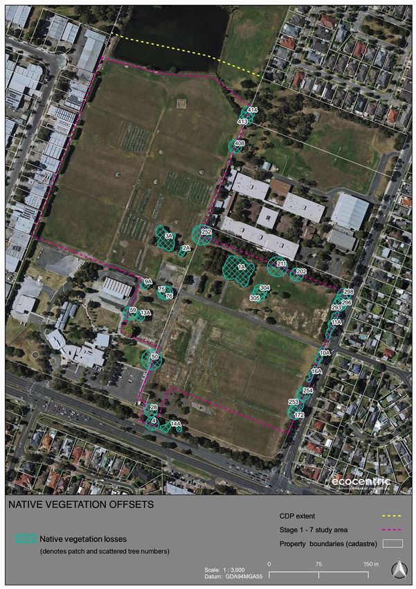
Away from property boundaries, inside the developable area, there are 10
patches (average of only 365m 2 per patch) of planted native canopy species
which offer limited habitat values in the form of canopy roosting and feeding
opportunities for bats (fruit and insectivorous taxa) and honeyeaters, and
roosting opportunities for passerine birds. Tree hollows are noticeably absent,
and there is little to no recruitment of understorey species due to dense organic
litter layers, the closed nature of the canopy, and regular herbicide application
for weed control; one exception, Patch 3A retains a ground log that may have
been placed on site for habitat values, and supports some limited regeneration
of understorey species (including two Swamp Paperbark (Melaeluca ericifolia),
two Fireweed (Senecio spp.) and scattered patches of Weeping Grass
(Microlaena stipoides var. stipoides). It is considered unlikely that these
patches would support threatened or significant flora or fauna. All patches of
native vegetation are assigned a rating of low habitat significance (see Table
1 for details).
Table 4 below presents the results of the VQA habitat hectare assessments for
the patches of native vegetation described above (see Appendix 9.6 maps for
patch locations).
Ecological Assessment: Stage 1 - 7 Development Area 609-619 & 621 Burwood Highway, Knoxfield
ECOCENTRIC Environmental Consulting
page 24You can also read