EFAS Bulletin European Flood Awareness System
←
→
Page content transcription
If your browser does not render page correctly, please read the page content below
European Flood Awareness System

EFAS Bulletin
August – September 2020
Issue 2020(5)
EUROPEAN FLOOD AWARENESS SYSTEM: Bimonthly Bulletin – Issue 2020(5)

NEWS                                                                    Events

New features                                                            EFAS Annual Meeting 2020 (online)

EFAS 4.0 – New version of EFAS Launched                                 The EFAS Annual Meeting took place on 22 October
EFAS version 4.0 was launched on 14 October 2020. It                    2020. This event took place online for the first time due
introduces a step-change with the medium-range en-                      to the COVID-19 pandemic. More than 160 participants
semble forecasts driven by ECMWF-ENS at a 6-hourly                      from the EFAS Partner community and four EFAS Cen-
time step.                                                              tres were in attendance.

EFAS-4 follows a complete recalibration at 6-hourly
time step of EFAS hydrological model, LISFLOOD, now
based on over 1100 river stations across the EFAS do-
main covering 60% of the full spatial domain. The
newly calibrated LISFLOOD results in a marked im-
provement in both the magnitude and timing of the
simulated flood peaks, especially in medium-size
catchments (see Figure 1 for an example of improved
hydrographs with EFAS-4). A detailed article regarding
the EFAS v4.0 update is published in the Articles sec-
tion of this bulletin.                                                  Figure 2: A selection of the many participants who joined the
                                                                        EFAS Annual Meeting online.

                                                                        The online meeting was well received, with healthy dis-
                                                                        cussions and feedback throughout. Items covered in
                                                                        the meeting included: (1) The status of the EFAS oper-
                                                                        ational service summarized from the 4 EFAS Centres
                                                                        including experiences, issues, challenges, (2) New de-
                                                                        velopments with regard to EFAS 4.0, (3) New products
                                                                        and services, (4) Detailed assessment of the floods in
                                                                        Spain in 2019, (5) The next steps for EFAS, (6) Develop-
                                                                        ments with regard to flash flooding product, and (7)
                                                                        Discussion on open data and new EFAS partner agree-
                                                                        ment. Content of the meeting including presentations
                                                                        and further information will be shared through the
                                                                        EFAS website at a later stage.

                                                                        Copernicus Hackathon 2020
                                                                        Due to the COVID-19 pandemic, the Copernicus Hacka-
                                                                        thon 2020 was hosted as a virtual event. The
                                                                        Hackathon was held online on 16-17-18 October 2020.

                                                                        Hackathon is for developers, designers, data wran-
                                                                        glers, data journalists, data enthusiasts, and everyone
                                                                        interested in exploiting potential of cutting-edge devel-
Figure 1: Hydrographs of the water balance layer provided by            opments. Topics covered were weather forecasting,
EFAS 3.6 (top) and EFAS-4 (bottom) for the Inn at Muehldorf,            risk modelling, and earth observation to improve infor-
Germany (12600km2) produced on 11 August 2020 : discharge               mation and services for emergency management and
observations (black), simulations forced with observed precip-          the general population, with a view to protect lives.
itation and air temperature (green) and with forcings from the
                                                                        The Hackathon focused on raising awareness about the
fill-up period (red), and medium-range ECMWF-ENS ensemble
forecasts (blue). (Information restricted to EFAS partners only).       Copernicus programme and promoting the benefits it

                                                                    2
EUROPEAN FLOOD AWARENESS SYSTEM: Bimonthly Bulletin – Issue 2020(5)

brings to crisis management and response at local, re-         153 Flash flood notification were issued in August -
gional, national, and international levels. Participants       September 2020. They are summarised in Table 2. The
of the Copernicus Hackathon were requested to use              locations of all notifications are shown in Figure 35 and
the provided tools and datasets in order deliver soft-         Figure 37 in the appendix.
ware developments supposing added value
downstream services, such as:                                  Meteorological situation
    • Develop web applications for policy-and deci-
         sion-makers.                                          by EFAS Meteorological Data Collection Centre
    • Apps & services for specific public and com-
         mercial needs (e.g. tourism, energy,                  August
         transport).                                           August 2020 was characterised by roughly normal
    • Effective communication of risks (environ-               monthly mean surface pressure in the EFAS domain,
         mental or societal challenges) to the public          only lower than normal around Spitsbergen. Monthly
         (participatory approach, crowdsourcing and            precipitation totals were below the long-term means
         social media data).                                   in an arc from northern Africa over the Black Sea to-
                                                               wards Scandinavia, with an extension to the Iberian
The challenges that participants addressed are shown           Peninsula and above normal elsewhere. Monthly mean
in detail on the event website. For more information,          air temperatures were below the long-term means
see the event homepage or visit social media: LinkedIn,        from western Russia to Iran and Turkey as well as at the
Twitter, Facebook.                                             western Iberian Peninsula while positive anomalies oc-
                                                               curred in the other parts of the EFAS domain.
New Partners
                                                               At the beginning of August 2020, the Azores High was
New EFAS Third Parties                                         around its usual position and a low-pressure system
We gladly welcome the National Fire and Rescue Au-             was located near Iceland, and another one over north-
thority, Israel, and the National Authority for                ern Russia, which brought notable precipitation
Emergency and Civil Protection, Portugal as new EFAS           amounts in this region in the first days of August. Even
Third Party partners.                                          as the low-pressure system near Iceland weakened at
                                                               the surface, an upper-level trough extended with a
New Research Partner                                           cold air advance towards central Europe. This caused
We gladly welcome the “Plastic waste and the Black             intense rainfall at the Alps and in the higher parts of
Sea” project, ARGANS, as a new EFAS Research part-             the mountains enough snowfall for skiing. Some local
ner. The project is a set of applications for the litter       floods appeared in the region. An upper-level low-pres-
monitoring in the Back Sea. EFAS data will be used to          sure system was cut-off from the trough and moved
implement the litter land model, as land-based plastic         along the Adriatic Sea, bringing intense rain to the
waste in relation with river flow contributes heavily to       western Balkans and Italy. In the same days, yet an-
the volume of marine litter. EFAS data will allow to           other low-pressure system moved from the Atlantic
have an estimate of the volume of litter carried by riv-       Ocean to Iceland and brought significant precipitation
ers in near real time.                                         amounts to Great Britain and Ireland. The high-pres-
                                                               sure system from Russia extended south-westwards,
                                                               developing a new core over the Baltics, which moved
RESULTS                                                        to Scandinavia and later back to the Baltics. A trough
                                                               developed over the eastern Atlantic Ocean towards the
Summary of EFAS Flood and Flash Flood Notifications            Iberian Peninsula and caused severe weather in Spain,
                                                               the United Kingdom, and France. Another upper-level
The 37 formal and 12 informal EFAS flood notifications         low-pressure system developed westward of Great
issued in August-September 2020 are summarised in              Britain and Ireland, moved across the Gulf of Biscay
Table 1. The locations of all notifications are shown in       and English Channel to Great Britain and Ireland,
Figure 34 and Figure 36 in the appendix.                       where it merged with a very strong low-pressure sys-
                                                               tem coming in from the Atlantic Ocean. It brought
                                                               strong winds to Great Britain and Ireland and later to

                                                           3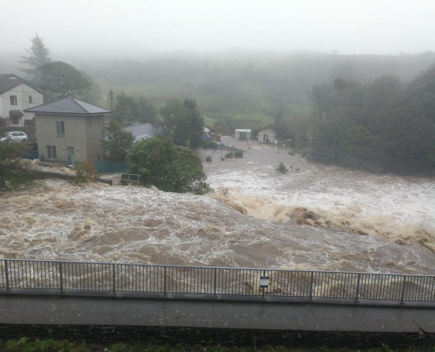
EUROPEAN FLOOD AWARENESS SYSTEM: Bimonthly Bulletin – Issue 2020(5)

western Scandinavia as it moved there. Only a few days           southeast. Monthly mean air temperatures were be-
later, another low-pressure system developed and in-             low the long-term means in parts of northern and
tensified very fast over the eastern Atlantic Ocean and          western Europe and Africa as well as in the east of the
moved across Great Britain and Ireland, and the North            EFAS domain, while positive anomalies occurred in the
Sea towards the Baltic Sea bringing very strong winds            other parts.
along its track. Worth mentioning is also a low-pres-
sure system over the Kola Peninsula. Both low-                   At the beginning of September 2020, the Icelandic Low
pressure systems brought notable precipitation                   and Azores High were around their usual positions
amounts. A few days later, another low-pressure sys-             while another high-pressure system was located over
tem moved on a similar track from the Atlantic Ocean             western Europe and Scandinavia, a low-pressure sys-
to the Baltic Sea. An upper-level trough developed               tem over the North Russian Lowlands and an upper-
from this low-pressure system over France and de-                level low-pressure system above the northern Adriatic
tached from it, moving slowly eastwards and causing              Sea. The upper-level system moved towards central
again heavy precipitation in and around the Alps. This           Europe causing intense precipitation at its eastern
was a similar situation as at the beginning of August,           edge and disappeared, while the high-pressure system
but it brought rain also at its eastern edge and to south-       moved via Scandinavia towards Russia. The Azores
ern France and the Balearic Islands.                             High extended to central Europe with the development
                                                                 of a new core over western Russia. The Icelandic Low
In August 2020, the highest precipitation totals were            intensified, causing continuous heavy rain in Great Brit-
observed over the Alps, Balkans and Great Britain and            ain and Ireland, and around the North Sea. Later, it
Ireland (Figure 20). No or almost no precipitation fell in       moved to Spitsbergen. Also at the beginning of August,
the south of the EFAS domain, in the south of the Ibe-           intense precipitation events associated with flash
rian Peninsula, and some regions to the north of the             floods were reported from Tunisia and Algeria. From
Black Sea. Monthly precipitation totals below the long-          the aforementioned low-pressure system, an upper-
term means occurred in the Scandinavia, north and                level trough developed over central Europe, was cut-
south of the Black Sea, the Baltics, in parts of south-          off and moved to the western and central Mediterra-
western and central Europe, and in the south of the              nean Sea, causing heavy precipitation with associated
EFAS domain (Figure 21). Monthly totals above the                flash floods. During the same days, a low-pressure sys-
long-term means were reported in the centre of the               tem moved from the Atlantic via Iceland to Scandinavia
EFAS domain but also around the Caspian Sea, Great               including the formation of secondary low-pressure sys-
Britain and Ireland, and parts of the Iberian Peninsula.         tems, which brought notable precipitation amounts
                                                                 there and eastward of Scandinavia. A weak high-pres-
The monthly mean air temperature ranged from -2.5°C              sure ridge developed from the Azores and extended to
to 38.2°C with the highest values in the southern parts          eastern Europe. By the middle of the month, a high-
of the EFAS domain. The lowest temperature values                pressure system developed over central and eastern
were reported in the northern and mountainous re-                Europe moving slowly eastward and an old low-pres-
gions (Figure 24). Air temperature anomalies ranged              sure system intensified again over the West Siberian
from -5.8°C to 7.9°C (Figure 25). Monthly mean air tem-          Plain. A low-pressure system formed over southern
peratures below the long-term means occurred from                Scandinavia, experienced a rapid intensification and
western Russia southward to Iran and Turkey, in parts            moved to western Russia, associated with strong winds
of Scandinavia, and the Iberian Peninsula. Positive              and continuous heavy rain. At the same time, a high-
monthly mean temperature anomalies were reported                 pressure system developed over the North Sea and a
in other parts of the EFAS domain.                               low-pressure system moved from the Atlantic Ocean to
                                                                 the west of the Iberian Peninsula and later the Bay of
September                                                        Biscay with notable rain amounts in southwest Europe.
September 2020 was characterised by roughly normal               In addition, the short-lived tropical storm “Alpha” de-
monthly mean surface pressure in the EFAS domain,                veloped west of Portugal and Medicane “Ianos” (also
only lower than normal around Spitsbergen. Monthly               named “Cassilda”) brought strong wind and heavy pre-
precipitation totals were below the long-term means              cipitation including flash floods to Greece and Crete,
in many regions in the EFAS domain, especially in the            and some coastal regions in Libya. A low-pressure sys-
                                                                 tem moved with strong wind via Iceland and northern

                                                             4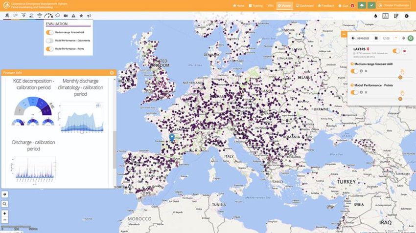
EUROPEAN FLOOD AWARENESS SYSTEM: Bimonthly Bulletin – Issue 2020(5)

Scandinavia to the West Siberian Plain. Weak pressure          Hydrological situation
gradients were found in the remaining EFAS domain,
allowing several convective precipitation events in the        by EFAS Hydrological Data Collection Centre
western and central Mediterranean Region. An upper-
level trough with several low-pressure cores at the sur-       August
face developed over Great Britain and Ireland and              In August, the main concentration of stations that ex-
extended to the central Mediterranean region,                  ceeded their lowest threshold level is located in central
whereas one of the cores moved to Scandinavia. It was          Europe: Poland and Germany (the Oder and Elbe basins
cut-off, with the centre over the Alps, weakened and           respectively); the Danube basin across Austria, Hun-
moved to the eastern Carpathian Mountains by the               gary, Slovakia and Croatia; the Po basin in Italy; and the
end of the month, associated with repeated continu-            southern Rhine basin in Switzerland. Exceedance took
ous heavy precipitation in central and eastern Europe,         place for more than twenty days in the stations located
and the Balkans. Another low-pressure trough devel-            on Parma, Riglio, and Stirone Rivers (the Po basin); on
oped over Iceland and extended to Great Britain and            the Tisza River; and on Lake Ossiach (the Danube ba-
Ireland, also associated with intense precipitation.           sin). As can be seen in Norway, four stations located on
                                                               the west side; the Storelvi, Breelvi, and Loelva rivers,
In September 2020, the highest precipitation totals            exceeded their threshold for two days. Three stations
were observed around the central Mediterranean re-             in the Bakkahlaup basin and one in the Skjalfandafljot
gion, northern Carpathian Mountains, and along the             basin (Iceland), and three stations in Spain (the Llobre-
western Scandinavian coast (Figure 22). No or almost           gat and Minho basins) exceeded their lowest threshold
no precipitation fell in the south-east of the EFAS do-        level.
main and north-west of the Caspian Sea. Monthly
precipitation totals below the long-term means oc-             The stations that exceeded the quantile 90% are scat-
curred in many parts of the EFAS domain, especially in         tered throughout the European continent. Spain
the east and south-east, but also at the southern Ibe-         stands out with 15 stations having values higher than
rian Peninsula, central Europe and the Baltic Bridge           this quantile in the Guadalquivir, Guadalhorce, Velez,
(Figure 23). Monthly totals above the long-term means          Minho, Ter, and Llobregat basins. The stations located
were reported in parts of the Mediterranean region,            in the Danube basin are remarkable too. These stations
eastern and northern Europe, and the northern Iberian          represent 36% of the stations that exceeded quantile
Peninsula. Two erroneous spots with high precipitation         90%. The rest of stations are in France (the Loire and
totals are in Syria/Jordan and Morocco/Algeria due to          Seine basins), Germany (the Rhine basin), Poland (the
single erroneous data points passing the automated             Oder basin), Ukraine (the Dnieper basin), southern and
quality control procedures as they were still below the        central Ireland, southern United Kingdom, and Nor-
thresholds.                                                    way.

The monthly mean air temperature ranged from -4.8°C            Finally, 63% of the stations that met the quantile value
to 36.7°C with the highest values in the southern parts        of under 10% for August are located in Poland, Ger-
of the EFAS domain. The lowest temperature values              many, and Belgium. The rest of the stations are
were reported in the northern and mountainous parts            scattered throughout the United Kingdom, the Nether-
(Figure 26). Air temperature anomalies ranged from -           lands, Spain, Romania, Ukraine, Czechia, Norway, and
6.3°C to 8.6°C (Figure 27). Monthly mean air tempera-          Sweden.
tures below the long-term means occurred in Iceland,
Great Britain, Ireland, and in some regions in Scandina-       September
via, the Iberian Peninsula, northern Africa, and eastern       For September, the highest concentration of stations
Europe. Positive monthly mean temperature anoma-               that exceeded their lowest threshold level (almost 50
lies were reported in other parts of the EFAS domain.          percent of the total number of stations that exceeded
                                                               this month) was located in Italy, in the Po river basin.
                                                               In central Europe, the Danube river basin is notable,
                                                               containing stations with their threshold level exceeded
                                                               in Austria, Slovenia, Germany, Hungary, and the Czech
                                                               Republic. Another concentration of stations can be

                                                           5
EUROPEAN FLOOD AWARENESS SYSTEM: Bimonthly Bulletin – Issue 2020(5)

seen across Norway and finally, some scattered sta-              Verification
tions are found between the Oder and Vistula river
basins on the west side of Poland.

With respect to stations registering values above the
90% quantile, these are located in central Europe,
mainly in the Danube (Austria, Romania, Serbia, Ger-
many, Slovakia, Ukraine, Czech Republic, Slovenia,
Bulgaria, Bosnia and Herzegovina, and Croatia) and
Rhine river basins. To a minor extent, values above 90%
quantile can be found in stations located in basins to
the north of the Danube (Dnieper, Vistula, Oder, Elbe)
and west Rhine river basins (Meuse, Rhône, Seine,
Loire, Vilaine, Hérault). Also, a high density of stations
exceeding the 90% quantile is located in Spanish (Ebro,
Douro, Guadalquivir, Minho and Ter) and Norwegian
river basins, mainly in the south-central area. Values
above the 90% quantile were also registered in isolated
stations in basins located in Great Britain and Ireland          Figure 3. EFAS CRPSS at lead-time 1 day for the August-Septem-
(Don, Exe, Mersey, Thames, Yare, Barrow and Shannon              ber 2020 period, for catchments >2000km2. The reference
basins), northern Finland basins (Naatamo, Kemijoki              score is persistence of using previous day’s forecast.
and Tana) and Sweden (Moälven basin).
                                                                 Figure 3 and Figure 4 shows the EFAS headline score,
                                                                 the continuous ranked probability skill score (CRPSS)
Finally, and regarding values under quantile 10%, the
                                                                 for lead times 1 and 5 days for the August to Septem-
greatest concentration of stations that met this condi-
                                                                 ber period across the EFAS domain for catchments
tion are located in southern Sweden, in the Hungarian
                                                                 larger than 2000km2. A CRPSS of 1 indicates perfect
Danube basin, and in north-eastern France (Rhone and
                                                                 skill, 0 indicates that the performance is equal to that
Seine basins). We can also find stations showing values
                                                                 of the reference, and any value 2000km2. The reference
                                                                 score is persistence of using previous day’s forecast.

                                                             6
EUROPEAN FLOOD AWARENESS SYSTEM: Bimonthly Bulletin – Issue 2020(5)

These maps indicate that across much of Europe for                    resolution compared with the daily time step issued up
forecasts are more skilful than persistence at both lead              until now — and statistical post-processed forecasts
times. Regions shown in blue are those where EFAS                     available on over 1000 stations. EFAS v4.0 follows a
forecasts are more skilful than persistence, with darker              complete recalibration at 6hourly time step at over
shading indicating better performance.                                1100 river stations across the EFAS domain covering
                                                                      50% of the full spatial domain (Figure 6).
The skill of the forecast was quite good over the period,
and better compared to the same period last year
(Figure 5). An inter-annual variability of the scores is to
be expected. The long-term trend is neutral over the
first two years since the domain was extended.

With the release of EFAS v4.0, skill scores are now
available on EFAS-IS. We will therefore no longer show
skill scores in the bimonthly bulletin.

                                                                      Figure 6: EFAS v4.0 - Area of EFAS Pan-European domain in-
                                                                      cluded in the calibration (in red) with associated calibration
                                                                      points (in blue).

                                                                      Hydrological modelling
                                                                      The hydrological model was calibrated using sub-daily
                                                                      and daily discharge data provided by EFAS partners up
Figure 5. Monthly means of CRPSS the for lead-time 5 days for         to July 2018.
all the major river points in Europe with ECMWF ENS as forcing.
Reference forecast was climatology. The skill is largest during       However, additional river gauges shared by EFAS part-
the winter months, when there is less variation in the flow in
                                                                      ners and managed by the Hydrological Data Collection
large parts of Europe.
                                                                      Centre (HDCC) after that date have been included as
                                                                      fixed reporting points where partners can monitor
                                                                      EFAS simulations over their catchment of interest. As
ARTICLES                                                              part of the continued evolution of the service, new
                                                                      fixed reporting points are added regularly by the team
EFAS version 4.0: the new cycle upgrade of the Eu-                    through the publication of new EFAS versions.
ropean Flood Awareness System
                                                                      The new calibrated LISFLOOD model produces marked
by Christel Prudhomme, Cinzia Mazzetti and the whole team of          improvements in both the magnitude and timing of
the EFAS Computational Forecast Centre.                               simulated flood peaks, especially in medium-size
                                                                      catchments (Figure 7). The Kling-Gupta Efficiency in-
On the 14 October 2020, the European Flood Aware-                     crease for 400 of the 540 common calibration points
ness System (EFAS) launched a new cycle upgrade,                      from EFAS3.6 to EFAS v4.0 (Figure 8).
EFAS version 4.0. It introduces a step-change in the
way river discharge is simulated and flood warnings are
calculated, with twice daily medium-range ensemble
forecasts driven by ECMWF-ENS now provided at a 6-
hourly time step — a 4-fold increase in the temporal

                                                                  7
EUROPEAN FLOOD AWARENESS SYSTEM: Bimonthly Bulletin – Issue 2020(5)

                                                                       Figure 8: Spatial distribution of Kling-Gupta Efficiency skill
                                                                       score between EFAS v4.0 and EFAS v3 (benchmark). For each
                                                                       point, size of the dot represents area of the upstream catch-
                                                                       ment. Blue shows improvements from EFAS v3 at the daily
                                                                       time step.

Figure 7: Hydrographs of the water balance layer provided by           Enhanced information for users
EFAS v3.6 (left) and EFAS v4.0 (right) for the Inn at Muehldorf,       To help users interpret EFAS forecasts, we added new
Germany (12600km2) produced on 11 August 2020 : discharge              layers describing the way LISFLOOD represent rivers
observations (black), simulations forced with observed precip-
                                                                       and locates reservoirs and lakes (available under the
itation and temperature (green) and with forcings from the fill-
up period (red), and medium-range ECMWF-ENS ensemble                   ‘Static’ tab in EFAS-IS map-viewer menu). We also
forecasts (blue).                                                      made some changes in the way the information is dis-
                                                                       played. For example, we introduced a new ‘evaluation’
                                                                       tab where summary of the hydrological model perfor-
                                                                       mance (see Figure 9) and forecast skills are provided.

Figure 9: Evaluation layers in EFAS v4.0 including a revamped hydrological model performance (with its redesigned pop-up win-
dow, insert) and a new medium-range forecast skill layer, available for all fixed reporting points (only calibration points for the
model performance layer).

                                                                   8
EUROPEAN FLOOD AWARENESS SYSTEM: Bimonthly Bulletin – Issue 2020(5)

The pop-up windows associated with the ‘Reporting                    EFAS v4.0: Forecasts of the Adige floods of 30 Au-
Point’ layers have been redesigned, with the discharge               gust 2020 (Italy)
forecasts hydrographs (Figure 10) and post-processed
forecasts (for those stations with real-time river dis-              by Cinzia Mazzetti
charge data available through the HDCC) available
                                                                     The Adige catchment
together, so that users can easily compare the simula-
tions and forecasts with their own observations. The                 The Adige is the second longest river in Italy, after the
persistence tables have been reconfigured for a more                 Po, and the third largest Italian catchment after Po and
intuitive reading, with the latest forecasts now on top              Tiber rivers. It flows in the Northern part of Italy, col-
of the figure. The information is provided for all the               lecting water from Alpine streams upstream of the
2651 EFAS fixed reporting points of EFAS version 4.0.                cities of Bolzano and Trento, crossing the city of Verona
                                                                     and finally flowing to the Adriatic Sea.

Figure 10: Six-hourly discharge hydrograph published twice
daily for all medium-range forecasts from EFAS 4.0, with both
discharge (left axis) and return period (right axis) shown to-
gether. Example of ECMWF-ENS forecast of 2020-10-12 12:00
UTC for the Hornad at Margecany (Slovakia).

Finally, we also are now publishing all produced EFAS
datasets through the Copernicus Climate Data Store. In
addition to the already available 30-days old EFAS real-
time forecasts and the EFAS historic simulations since
EFAS-2, now also real-time EFAS seasonal outlooks and                Figure 11: The Adige river catchment in Italy. From Chiogna, G.
ECMWF-based EFAS medium-range and seasonal re-                       et al., 2015. A review of hydrological and chemical stressors in
forecasts are part of the CDS so that users can conduct              the Adige catchment and its ecological status. The Science of
their own local evaluation and use data for down-                    the total environment. 343. 10.1016/j.scitotenv.2015.06.149.
stream applications.
                                                                     The flood event of the 29th- 31st August 2020
                                                                     Between the 29 and 30 August 2020, northern Italy ex-
Additional Information
                                                                     perienced heavy rainfall that lead to severe flash floods
Supplementary documentation detailing the EFAS sys-
                                                                     and riverine floods in many areas, with associated in-
tem (model, products, and service) and its upgrades
                                                                     creased landslide risk in some places. The Adige
are provided through dedicated Wiki pages.
                                                                     catchment was severely hit. The river and one of its
                                                                     main affluents, the Isarco, burst their banks and
A new medium- to sub-seasonal range reforecast, sea-
                                                                     flooded large areas. More than 600 inhabitants were
sonal forecast and seasonal hindcast datasets have
                                                                     evacuated from their homes in Egna, and people were
also been released with EFAS v4.0. Seasonal and sea-
                                                                     told to flee to higher storeys of their buildings. The
sonal reforecasts datasets will be available from ~10
                                                                     most affected area was the Adige valley between the
November 2020 following the first seasonal forecast in
                                                                     cities of Bolzano and Trento, where water caused the
EFAS v4.0. The reforecasts are available through the
                                                                     temporary closure of the highway and the railroad be-
CDS: https://doi.org/10.24381/cds.c83f560f
                                                                     tween Italy and Austria.

                                                                 9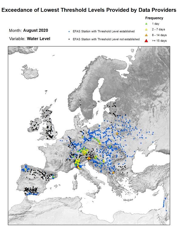
EUROPEAN FLOOD AWARENESS SYSTEM: Bimonthly Bulletin – Issue 2020(5)

                                                                       event struck the Adige catchment and the team at EFAS
                                                                       Forecast Computational Centre got the chance to ob-
                                                                       serve results from the new system.

                                                                       The first signal of the upcoming event was captured by
                                                                       EFAS v4.0 as early as 7 days before the flood peak, in
                                                                       the forecast from the 00 UTC run on the 23 August,
                                                                       when a 2-year return period reporting point appeared
                                                                       at Bronzolo (Bolzano) river gauge. A 5-year return pe-
                                                                       riod reporting point appeared at the same station the
Figure 12: The river Adige during the 29-30 August flood event.        day after, in EFAS v4.0 forecast from the 12 UTC run on
Credits:https://www.trentotoday.it/cronaca/maltempo-                   the 24 August (Figure 14).
adige-piena.html
                                                                       In EFAS v4.0 forecast from the 12 UTC run on the 28
The flood peak was recorded at the gauging station of
                                                                       August, 48 hours before the flood peak in Bronzolo, the
Bronzolo (Bolzano) in the afternoon of 30 August 2020
                                                                       flood signal was clearly indicating 30th August as the
(Figure 13), marking one of the highest peaks in the last
                                                                       most probable day for the flood peak. The new 6-
30 years with ~1350 m3/s.
                                                                       hourly forecast overview tables were also clearly show-
                                                                       ing the timing of the peak using the new sub-daily time
The European Flood Awareness System (EFAS) version
                                                                       scale (Figure 15).
4.0 had already entered its testing phase when the

Figure 13: Observed discharge recorded at Bronzolo gauging station (courtesy of Provincia Autonoma di Bolzano Alto Adige). EFAS
version 4.0 forecasts

                                                                  10
EUROPEAN FLOOD AWARENESS SYSTEM: Bimonthly Bulletin – Issue 2020(5)
Figure 14: EFAS v4.0 forecast from the 00 UTC run on 23 August 2020. Top left is EFAS v4.0 reporting point layer, top right is EFAS
v4.0 discharge forecast at Bronzolo, bottom is forecast overview at Bronzolo.
Figure 15: EFAS v4.0 forecast from the 12 UTC run on 28 August 2020. Top left is EFAS v4.0 reporting point layer, top right is EFAS
v4.0 discharge forecast at Bronzolo, bottom is forecast overview at Bronzolo.
11EUROPEAN FLOOD AWARENESS SYSTEM: Bimonthly Bulletin – Issue 2020(5)
A few days later, on 1 September, when maps contain- Homes and schools were evacuated after flash floods
ing observed precipitation and air temperature were in County Galway, western Ireland on 2 September
ingested in LISFLOOD, the hydrological model pro- 2020. The flooding came after heavy rainfall overnight,
duced a hydrograph whose magnitude and timing were 1-2 September, caused rivers including the Owenglin
consistent with observations at Bronzolo station River to break their banks. The coastal town of Clifden
(Figure 16). was particularly badly affected. Local observers said
the speed at which the flooding occurred in the town
was unprecedented. Fire and Rescue Service evacu-
ated a number of people from approximately 17
properties in Clifden. Police said flooding from the Ow-
englin river caused temporary closure of parts of
Clifden town. Galway County Council said that at least
six roads in the area were closed. Most were reopened
to traffic later on 2 September.
Rainfall and Warnings
Figure 16: The left part of the graphs (black dots) shows the
output of LISFLOOD model when forced with observations at The weather station at Connemara National Park Auto-
the station of Bronzolo. matic, located in near Letterfrack, around 8km north
east of Clifden, recorded 60mm of rain in a few hours
What’s next? early on 02 September.
EFAS version 4.0 was implemented as the operational
system of EFAS the 14 October 2020. The forecasts pro-
duced for the Adige floods of the end of August 2020
are very encouraging, but of course, the team of the
Computational Forecast Centre will continue to closely
monitor forecasts and assess the modelling perfor-
mance. EFAS partners are encouraged to also monitor
EFAS forecasts in their region and to inform the EFAS
centres how EFAS v4.0 performs locally.
Flooding in County Galway, Ireland, September Figure 18: Rainfall in early September 2020 measured at the
2020 Connemara National Park weather station near Letterfrack,
Galway. Image / data: Met Eireann
by Richard Davies, floodlist and Karen O’Regan In a statement of 2 September, Galway County Council
said:
“Met Éireann issued a Status Yellow Rainfall Warning
for Mayo, Sligo, Leitrim and Donegal on the 1st Sep-
tember 2020... The warning did not extend to Galway,
however the weather system pushed south into the
Galway resulting in a period of high Intensity Rainfall in
the Connemara area from 10pm last night to 8am this
morning where up to 50mm of rainfall was recorded.
This resulted in a surge in rivers causing a series of
flooding events on roads in the Connemara area with
the town of Clifden significantly impacted by heavy
flooding from the Owenglin River.”
Figure 17: Flooding from the Owenglin river in Clifden, 02 Sep- Copernicus EMS Maps
tember 2020. Credit: Elena Vaughan, published with
permission
The Copernicus Emergency Management Service was
activated in Rapid Mapping mode on 02 September
12EUROPEAN FLOOD AWARENESS SYSTEM: Bimonthly Bulletin – Issue 2020(5)
(EMSR460), to provide satellite maps of the areas af-
fected by the flooding event.
Figure 19: Copernicus EMS map of Galway floods, 2 September. Credit; Copernicus EMS
Flood Relief Scheme The State of Flood Forecasting in Ireland
The Minister of State with responsibility for the Office Following extensive flooding in the winter of
of Public Works, Patrick O’Donovan TD, visited flood- 2015/2016, the Government of Ireland decided to es-
hit areas of Clifden on 2 and 3 September. Minister tablish a National Flood Forecast and Warning Service
O’Donovan said: (NFFWS) to forecast for fluvial and coastal floods. The
operational element of the NFFWS, a Flood Forecast
“It is only when you see the damage that you can fully Centre (FFC) is to be implemented by Met Éireann (The
appreciate the devastation caused to this community. I Irish Meteorological Service), while the Office of Public
wish to assure local residents of the support from gov- Works will provide guidance and standards.
ernment to assist in the recovery of those affected and
our commitment to working with Galway County Coun- Stage 1 will involve the development of fluvial flood
cil to progress the Flood Relief Scheme for the town... forecasting models at a National and Catchment level.
The OPW, in partnership with Local Authorities, is work- Ireland has 36 such hydrometric areas and catchment
ing to deliver a significant planned programme of flood models will be built for each of these. A review of flu-
relief schemes, and this €1 billion investment will en- vial models and integrator systems was undertaken by
sure that this and future generations will no longer live Met Éireann, and the HYPE model was selected for the
with the risk, fear and impact from flooding.” operational fluvial model for the FFC. It is expected that
a non-operational trial of the FCC will commence in Q3
2021.
13EUROPEAN FLOOD AWARENESS SYSTEM: Bimonthly Bulletin – Issue 2020(5)
Acknowledgements
The following partner institutes and contributors are gratefully acknowledged for their contribution:
• DG GROW - Copernicus and DG ECHO for funding the EFAS Project
• All data providers including meteorological data providers, hydrological services & weather forecasting centres
• The EFAS Operational Centres
• Richard Davies, Floodlist.com
Cover image: Flooding from the Owenglin river in Clifden, Galway, Ireland, 02 September 2020. Credit: Elena
Vaughan, published with permission.
14EUROPEAN FLOOD AWARENESS SYSTEM: Bimonthly Bulletin – Issue 2020(5)
Appendix – figures
Figure 20. Accumulated precipitation [mm] for August 2020. Figure 22. Accumulated precipitation [mm] for September
2020.
Figure 21. Precipitation anomaly [%] for August 2020, relative Figure 23. Precipitation anomaly [%] for September 2020, rela-
to a long-term average (1990-2013). Blue (red) denotes wetter tive to a long-term average (1990-2013). Blue (red) denotes
(drier) conditions than normal. wetter (drier) conditions than normal.
15EUROPEAN FLOOD AWARENESS SYSTEM: Bimonthly Bulletin – Issue 2020(5)
Figure 24. Mean temperature [°C] for August 2020. Figure 26. Mean temperature [°C] for September 2020.
Figure 25. Temperature anomaly [°C] for August 2020, relative Figure 27. Temperature anomaly [°C] for September 2020, rel-
to a long-term average (1990-2013). Blue (red) denotes colder ative to a long-term average (1990-2013). Blue (red) denotes
(warmer) temperatures than normal. colder (warmer) temperatures than normal.
16EUROPEAN FLOOD AWARENESS SYSTEM: Bimonthly Bulletin – Issue 2020(5)
Figure 28. Monthly discharge anomalies August 2020. Figure 30. Monthly discharge anomalies September 2020.
Figure 29. Lowest alert level exceedance for August 2020. Figure 31. Lowest alert level exceedance for September 2020.
17EUROPEAN FLOOD AWARENESS SYSTEM: Bimonthly Bulletin – Issue 2020(5)
.
Figure 32. Lowest threshold exceedance for August 2020. Figure 33. Lowest threshold exceedance for September 2020.
18EUROPEAN FLOOD AWARENESS SYSTEM: Bimonthly Bulletin – Issue 2020(5)
Figure 34. EFAS flood notifications sent for August 2020. Figure 36. EFAS flood notifications sent for September 2020.
Figure 35. Flash flood notifications sent for August 2020. Figure 37. Flash flood notifications sent for September 2020.
19Appendix - tables
Table 1: EFAS flood notifications sent in August - September 2020
Type Forecast date Issue date Lead River Country
time
Formal 31/07/2020 12UTC 01/08/2020 2 Saalach Austria
Informal
Flood 31/07/2020 12UTC 01/08/2020 2 Enns Austria
Informal
Flood 31/07/2020 12UTC 01/08/2020 2 Mur Austria
Informal
Flood 01/08/2020 12UTC 02/08/2020 1 Traun Austria
Flood
Informal 01/08/2020 12UTC 02/08/2020 2 Gurk Austria
Informal
Flood 03/08/2020 00UTC 03/08/2020 0 Mincio Italy
Formal
Flood 03/08/2020 00UTC 03/08/2020 3 Mur Hungary
Formal
Flood 03/08/2020 00UTC 03/08/2020 3 Mur Croatia
Flood
Formal 03/08/2020 00UTC 03/08/2020 1 Mur Slovenia
Informal
Flood 03/08/2020 12UTC 04/08/2020 1 Iller Germany
Informal
Flood 03/08/2020 12UTC 04/08/2020 0 Amper Germany
Formal
Flood 03/08/2020 12UTC 04/08/2020 0 Isar Germany
Flood
Informal 04/08/2020 00UTC 04/08/2020 0 Inn Germany
Informal
Flood 04/08/2020 00UTC 04/08/2020 0 Thaya Austria
Formal
Flood 04/08/2020 00UTC 04/08/2020 2 Drava Hungary
Formal
Flood 04/08/2020 00UTC 04/08/2020 3 Drava Croatia
Flood
Formal 04/08/2020 12UTC 05/08/2020 1 Thaya Czechia
Formal
Flood 25/08/2020 12UTC 26/08/2020 3 Ter Spain
Formal
Flood 25/08/2020 12UTC 26/08/2020 3 Adige Italy
Informal
Flood 26/08/2020 00UTC 26/08/2020 3 Rhine Austria
Flood
Informal 26/08/2020 00UTC 26/08/2020 3 Ill Austria
Formal
Flood 26/08/2020 00UTC 26/08/2020 3 Rhine Austria
Formal
Flood 26/08/2020 00UTC 26/08/2020 3 Lago Maggiore Switzerland
Informal
Flood 26/08/2020 00UTC 26/08/2020 3 Ill Austria
Flood
Informal 26/08/2020 00UTC 26/08/2020 3 Ticino Switzerland
Informal
Flood 26/08/2020 00UTC 26/08/2020 3 Rhine Switzerland
Formal
Flood 26/08/2020 00UTC 26/08/2020 3 Rhine Switzerland
Informal
Flood 26/08/2020 12UTC 27/08/2020 3 Lieser Austria
Flood
Formal 27/08/2020 00UTC 27/08/2020 2 Adda Italy
Formal
Flood 27/08/2020 00UTC 27/08/2020 2 Segre Spain
Formal
Flood 27/08/2020 00UTC 27/08/2020 2 Llobregat Spain
Informal
Flood 27/08/2020 00UTC 27/08/2020 2 Hinterrhein Switzerland
Flood
Informal 27/08/2020 12UTC 28/08/2020 1 Mincio Italy
Informal
Flood 27/08/2020 12UTC 28/08/2020 2 Adda Italy
Formal
Flood 27/08/2020 12UTC 28/08/2020 2 Reuss Switzerland
Formal
Flood 27/08/2020 12UTC 28/08/2020 3 Untersee Switzerland
Flood
Informal 28/08/2020 12UTC 29/08/2020 1 Thur Switzerland
Informal
Flood 15/09/2020 00UTC 15/09/2020 2 Kymijoki sub-catchment Finland
Informal
Flood 16/09/2020 00UTC 16/09/2020 2 Kifisos Greece
Informal
Flood 17/09/2020 12UTC 18/09/2020 1 Alfeios Greece
Flood
Informal 18/09/2020 00UTC 18/09/2020 0 Acheloos Greece
Informal
Flood 18/09/2020 00UTC 18/09/2020 1 Pineios Greece
Formal
Flood 23/09/2020 12UTC 24/09/2020 0 Drin-Buna Albania
Informal
Flood 24/09/2020 00UTC 24/09/2020 2 Slana Slovakia
Flood
Informal 24/09/2020 12UTC 25/09/2020 1 Hron Slovakia
Flood
20Informal 26/09/2020 12UTC 27/09/2020 1 Volturno Italy
Informal
Flood 27/09/2020 00UTC 27/09/2020 1 Krupa Bosnia And Her-
Informal
Flood 27/09/2020 12UTC 28/09/2020 1 Gurk Austria
zegovina
Flood
Formal 29/09/2020 00UTC 29/09/2020 6 Gurk Austria
Flood
a. * Lead time [days] to the first forecasted exceedance of the 5-year simulated discharge threshold.
Table 2: EFAS flash flood notifications sent in August - September 2020
Type Forecast date Issue date Lead Region Country
time
Flash Flood 31/07/2020 12UTC 01/08/2020 54 Tirol Austria
Flash Flood 31/07/2020 12UTC 01/08/2020 60 Lombardia Italy
Flash Flood 31/07/2020 12UTC 01/08/2020 60 Steiermark Austria
Flash Flood 31/07/2020 12UTC 01/08/2020 60 Salzburg Austria
Provincia Autonoma di Bol-
Flash Flood 01/08/2020 00UTC 01/08/2020 60 zano/Bozen Italy
Flash Flood 01/08/2020 12UTC 02/08/2020 60 Kraj Vysocina Czech Republic
Flash Flood 01/08/2020 12UTC 02/08/2020 60 Niederosterreich Austria
Flash Flood 01/08/2020 12UTC 02/08/2020 60 Karnten Austria
Flash Flood 01/08/2020 12UTC 02/08/2020 36 Oberosterreich Austria
Flash Flood 01/08/2020 12UTC 02/08/2020 60 Jihomoravsky kraj Czech Republic
Flash Flood 02/08/2020 00UTC 02/08/2020 54 Jihocesky kraj Czech Republic
Flash Flood 02/08/2020 12UTC 03/08/2020 48 Vorarlberg Austria
Flash Flood 02/08/2020 12UTC 03/08/2020 36 Oberbayern Germany
Flash Flood 03/08/2020 00UTC 03/08/2020 36 Schwaben Germany
Provincia Autonoma di Bol-
Flash Flood 03/08/2020 00UTC 03/08/2020 24 zano/Bozen Italy
Flash Flood 03/08/2020 00UTC 04/08/2020 36 Vorarlberg Austria
Flash Flood 03/08/2020 12UTC 04/08/2020 42 Durres Albania
Flash Flood 03/08/2020 12UTC 04/08/2020 48 Diber Albania
Flash Flood 03/08/2020 12UTC 04/08/2020 48 Poloski N. Macedonia
Flash Flood 03/08/2020 12UTC 04/08/2020 42 Lezhe Albania
Flash Flood 03/08/2020 12UTC 04/08/2020 48 Jugozapaden N. Macedonia
Flash Flood 03/08/2020 12UTC 04/08/2020 78 Korce Albania
Flash Flood 03/08/2020 12UTC 04/08/2020 48 Pelagoniski N. Macedonia
Flash Flood 03/08/2020 12UTC 04/08/2020 48 Ipeiros Greece
Flash Flood 03/08/2020 12UTC 04/08/2020 48 Dytiki Makedonia Greece
Flash Flood 04/08/2020 00UTC 04/08/2020 30 Del-Dunantul Hungary
Flash Flood 04/08/2020 00UTC 04/08/2020 30 Nyugat-Dunantul Hungary
Republic Of Ko-
Flash Flood 04/08/2020 12UTC 05/08/2020 24 Prizren sovo*
Flash Flood 04/08/2020 12UTC 05/08/2020 24 Kukes Albania
Flash Flood 04/08/2020 12UTC 05/08/2020 42 Zlatiborska oblast Serbia
Flash Flood 05/08/2020 00UTC 05/08/2020 24 Rasinska oblast Serbia
Bosnia And Her-
Flash Flood 05/08/2020 00UTC 05/08/2020 24 Republika Srpska zegovina
Flash Flood 07/08/2020 00UTC 07/08/2020 42 Poloski N. Macedonia
Flash Flood 07/08/2020 00UTC 07/08/2020 42 Pelagoniski N. Macedonia
Flash Flood 07/08/2020 00UTC 07/08/2020 30 Korce Albania
21Flash Flood 07/08/2020 00UTC 07/08/2020 36 Ipeiros Greece
Flash Flood 08/08/2020 00UTC 08/08/2020 12 Dytiki Makedonia Greece
Flash Flood 08/08/2020 00UTC 08/08/2020 18 Jugozapaden N. Macedonia
Flash Flood 10/08/2020 12UTC 11/08/2020 60 Zaragoza Spain
Flash Flood 13/08/2020 00UTC 13/08/2020 54 Oberosterreich Austria
Flash Flood 13/08/2020 00UTC 13/08/2020 54 Steiermark Austria
Flash Flood 13/08/2020 00UTC 13/08/2020 54 Niederosterreich Austria
Flash Flood 13/08/2020 12UTC 14/08/2020 66 Bihor Romania
Flash Flood 13/08/2020 12UTC 14/08/2020 42 Unterfranken Germany
Flash Flood 15/08/2020 00UTC 15/08/2020 30 Sofia (stolitsa) Bulgaria
Flash Flood 15/08/2020 00UTC 15/08/2020 30 Moravicka oblast Serbia
Flash Flood 15/08/2020 00UTC 15/08/2020 30 Pcinjska oblast Serbia
Flash Flood 15/08/2020 00UTC 15/08/2020 30 Sofia Bulgaria
Flash Flood 15/08/2020 00UTC 15/08/2020 30 Montana Bulgaria
Flash Flood 15/08/2020 12UTC 16/08/2020 24 Pernik Bulgaria
Flash Flood 17/08/2020 00UTC 17/08/2020 24 Niederosterreich Austria
Flash Flood 17/08/2020 00UTC 17/08/2020 60 Moravicka oblast Serbia
Flash Flood 17/08/2020 12UTC 18/08/2020 42 Branicevska oblast Serbia
Flash Flood 17/08/2020 12UTC 18/08/2020 54 Region Vojvodine Serbia
Flash Flood 18/08/2020 00UTC 18/08/2020 60 Mures Romania
Region Sumadije i Zapadne
Flash Flood 18/08/2020 00UTC 18/08/2020 36 Srbije Serbia
Flash Flood 18/08/2020 00UTC 18/08/2020 60 Brasov Romania
Flash Flood 18/08/2020 00UTC 18/08/2020 42 Moravicka oblast Serbia
Flash Flood 19/08/2020 00UTC 19/08/2020 18 Pelagoniski N. Macedonia
Flash Flood 19/08/2020 00UTC 19/08/2020 30 Suceava Romania
Flash Flood 24/08/2020 00UTC 24/08/2020 36 Moravicka oblast Serbia
Flash Flood 24/08/2020 00UTC 24/08/2020 36 Northern Ireland United Kingdom
Flash Flood 24/08/2020 12UTC 25/08/2020 30 Brasov Romania
Flash Flood 24/08/2020 12UTC 25/08/2020 30 Sibiu Romania
Flash Flood 27/08/2020 00UTC 27/08/2020 60 Girona Spain
Flash Flood 27/08/2020 12UTC 28/08/2020 48 Ticino Switzerland
Provincia Autonoma di Bol-
Flash Flood 27/08/2020 12UTC 28/08/2020 54 zano/Bozen Italy
Flash Flood 27/08/2020 12UTC 28/08/2020 42 Tirol Austria
Flash Flood 27/08/2020 12UTC 28/08/2020 60 Ostergotlands lan Sweden
Flash Flood 27/08/2020 12UTC 28/08/2020 30 North Yorkshire United Kingdom
Flash Flood 27/08/2020 12UTC 28/08/2020 30 Lincolnshire United Kingdom
Flash Flood 27/08/2020 12UTC 28/08/2020 54 St. Gallen Switzerland
Flash Flood 27/08/2020 12UTC 28/08/2020 36 Graubunden Switzerland
Flash Flood 27/08/2020 12UTC 28/08/2020 48 Lombardia Italy
Flash Flood 28/08/2020 00UTC 28/08/2020 48 Karnten Austria
Flash Flood 28/08/2020 00UTC 28/08/2020 48 Steiermark Austria
Flash Flood 28/08/2020 00UTC 28/08/2020 48 Friuli-Venezia Giulia Italy
Flash Flood 28/08/2020 00UTC 28/08/2020 48 Veneto Italy
Flash Flood 28/08/2020 00UTC 28/08/2020 54 Salzburg Austria
Flash Flood 28/08/2020 12UTC 29/08/2020 24 Piemonte Italy
Flash Flood 28/08/2020 12UTC 29/08/2020 48 Thurgau Switzerland
Provincia Autonoma di Bol-
Flash Flood 29/08/2020 00UTC 29/08/2020 36 zano/Bozen Italy
Flash Flood 29/08/2020 00UTC 29/08/2020 30 Uri Switzerland
22Flash Flood 29/08/2020 00UTC 29/08/2020 36 Tirol Austria
Flash Flood 29/08/2020 00UTC 29/08/2020 30 Lombardia Italy
Flash Flood 31/08/2020 12UTC 01/09/2020 24 Jihomoravsky kraj Czech Republic
Flash Flood 02/09/2020 12UTC 03/09/2020 48 Harghita Romania
Flash Flood 04/09/2020 12UTC 05/09/2020 60 Niederosterreich Austria
Flash Flood 12/09/2020 00UTC 12/09/2020 30 Highlands and Islands United Kingdom
Flash Flood 16/09/2020 00UTC 16/09/2020 66 Madrid Spain
Flash Flood 16/09/2020 00UTC 16/09/2020 72 Zaragoza Spain
Flash Flood 16/09/2020 00UTC 16/09/2020 66 Toledo Spain
Flash Flood 16/09/2020 00UTC 16/09/2020 66 Toledo Spain
Flash Flood 16/09/2020 00UTC 16/09/2020 66 Toledo Spain
Flash Flood 16/09/2020 12UTC 17/09/2020 60 Attiki Greece
Flash Flood 17/09/2020 00UTC 17/09/2020 42 Ciudad Real Spain
Flash Flood 17/09/2020 00UTC 17/09/2020 36 Ciudad Real Spain
Flash Flood 17/09/2020 12UTC 18/09/2020 36 Ionia Nisia Greece
Flash Flood 17/09/2020 12UTC 18/09/2020 42 Dytiki Ellada Greece
Flash Flood 17/09/2020 12UTC 18/09/2020 42 Sterea Ellada Greece
Flash Flood 17/09/2020 12UTC 18/09/2020 42 Thessalia Greece
Flash Flood 18/09/2020 00UTC 18/09/2020 18 Dytiki Makedonia Greece
Flash Flood 18/09/2020 00UTC 18/09/2020 18 Ipeiros Greece
Flash Flood 21/09/2020 12UTC 22/09/2020 48 Ipeiros Greece
Flash Flood 22/09/2020 00UTC 22/09/2020 54 Durres Albania
Flash Flood 22/09/2020 12UTC 23/09/2020 48 Zaragoza Spain
Flash Flood 22/09/2020 12UTC 23/09/2020 42 Jugozapaden N. Macedonia
Flash Flood 23/09/2020 00UTC 23/09/2020 30 Poloski N. Macedonia
Flash Flood 23/09/2020 00UTC 23/09/2020 30 Diber Albania
Flash Flood 23/09/2020 12UTC 24/09/2020 42 Friuli-Venezia Giulia Italy
Flash Flood 24/09/2020 00UTC 24/09/2020 36 Karnten Austria
Flash Flood 24/09/2020 00UTC 24/09/2020 54 Korce Albania
Flash Flood 24/09/2020 00UTC 24/09/2020 30 Gorenjska Slovenia
Flash Flood 24/09/2020 00UTC 24/09/2020 54 Elbasan Albania
Flash Flood 24/09/2020 00UTC 24/09/2020 48 Lezhe Albania
Flash Flood 24/09/2020 00UTC 24/09/2020 54 Diber Albania
Flash Flood 24/09/2020 00UTC 24/09/2020 54 Durres Albania
Flash Flood 24/09/2020 00UTC 24/09/2020 54 Gjirokaster Albania
Flash Flood 24/09/2020 00UTC 24/09/2020 54 Pelagoniski N. Macedonia
Flash Flood 24/09/2020 00UTC 24/09/2020 54 Jugozapaden N. Macedonia
Flash Flood 24/09/2020 00UTC 24/09/2020 54 Poloski N. Macedonia
Flash Flood 24/09/2020 00UTC 24/09/2020 54 Ipeiros Greece
Flash Flood 24/09/2020 00UTC 24/09/2020 54 Dytiki Makedonia Greece
Flash Flood 24/09/2020 12UTC 25/09/2020 30 Lincolnshire United Kingdom
Flash Flood 24/09/2020 12UTC 25/09/2020 42 Banskobystricky kraj Slovakia
Flash Flood 25/09/2020 00UTC 25/09/2020 24 Fier Albania
Flash Flood 25/09/2020 00UTC 25/09/2020 48 Karlsruhe Germany
Flash Flood 25/09/2020 00UTC 25/09/2020 42 Valcea Romania
Flash Flood 25/09/2020 00UTC 25/09/2020 24 East Anglia United Kingdom
Flash Flood 25/09/2020 12UTC 26/09/2020 30 Arges Romania
Flash Flood 25/09/2020 12UTC 26/09/2020 24 Telemark Norway
Flash Flood 25/09/2020 12UTC 26/09/2020 18 Ostfold Norway
Flash Flood 25/09/2020 12UTC 26/09/2020 24 Jihocesky kraj Czech Republic
Flash Flood 25/09/2020 12UTC 26/09/2020 24 Niederosterreich Austria
23Flash Flood 25/09/2020 12UTC 26/09/2020 36 Ivano-Frankivs'k Ukraine
Flash Flood 26/09/2020 00UTC 26/09/2020 6 Diber Albania
Flash Flood 26/09/2020 00UTC 26/09/2020 6 Ipeiros Greece
Flash Flood 26/09/2020 00UTC 26/09/2020 6 Pelagoniski N. Macedonia
Flash Flood 26/09/2020 00UTC 26/09/2020 6 Jugozapaden N. Macedonia
Flash Flood 26/09/2020 00UTC 26/09/2020 6 Poloski N. Macedonia
Flash Flood 26/09/2020 00UTC 26/09/2020 6 Dytiki Makedonia Greece
Flash Flood 26/09/2020 00UTC 26/09/2020 48 Lezhe Albania
Flash Flood 26/09/2020 00UTC 26/09/2020 6 Durres Albania
Flash Flood 26/09/2020 00UTC 26/09/2020 48 Korce Albania
Flash Flood 26/09/2020 12UTC 27/09/2020 24 L'viv Ukraine
Flash Flood 27/09/2020 12UTC 28/09/2020 30 Tirane Albania
Flash Flood 28/09/2020 00UTC 28/09/2020 42 Harghita Romania
Flash Flood 28/09/2020 12UTC 29/09/2020 54 Arges Romania
Falesti Glodeni Riscani Balti
Flash Flood 29/09/2020 00UTC 29/09/2020 12 and Singerei Moldova
Flash Flood 29/09/2020 00UTC 29/09/2020 12 Iasi Romania
Flash Flood 29/09/2020 00UTC 29/09/2020 12 Botosani Romania
Flash Flood 29/09/2020 00UTC 29/09/2020 24 Khmel'nyts'kyy Ukraine
Edinet Briceni Donduseni
Flash Flood 29/09/2020 00UTC 29/09/2020 24 and Ocnita Moldova
a. * Lead time [hours] to the forecasted peak of the event
24The European Flood Awareness System (EFAS) produces European overviews of ongoing and forecasted floods
up to 10 days in advance and contributes to better protection of the European citizens, the environment, prop-
erties and cultural heritage. It has been developed at the European Commission’s in-house science service, the
Joint Research Centre (JRC), in close collaboration with national hydrological and meteorological services and
policy DG's of the European Commission.
EFAS has been transferred to operations under the European Commission's COPERNICUS Emergency Manage-
ment Service led by DG GROW in direct support to the EU’s Emergency Response Coordination Centre (ERCC) of
DG ECHO and the hydrological services in the Member States.
ECMWF has been awarded the contract for the EFAS Computational centre. It is responsible for providing daily
operational EFAS forecasts and 24/7 support to the technical system.
A consortium of Swedish Meteorological and Hydrological Institute (SMHI), Rijkswaterstaat (RWS) and Slovak Hy-
dro-Meteorological Institute (SHMU) has been awarded the contract for the EFAS Dissemination centre. They are
responsible for analysing EFAS output and disseminating information to the partners and the ERCC.
A Spanish consortium (REDIAM and SOOLOGIC) has been awarded the contract for the EFAS Hydrological data
collection centre. They are responsible for collecting discharge and water level data across Europe.
A German consortium (KISTERS and DWD) has been awarded the contract for the EFAS Meteorological data col-
lection centre. They are responsible for collecting the meteorological data needed to run EFAS over Europe.
Finally, the JRC is responsible for the overall project management related to EFAS and further development of the
system.
Contact details:
European Centre for Medium-Range Weather Forecasts (ECMWF)
Shinfield Park, Reading,
RG2 9AX, UK
Tel: +44-118-9499-303
Fax: +44-118-9869-450
Email: comp@efas.eu
www.efas.eu
www.ecmwf.int
25You can also read