EMSC Real Time Earthquake Information Services
←
→
Page content transcription
If your browser does not render page correctly, please read the page content below

EMSC                                                    Real Time Earthquake Information Services

                                          European-Mediterranean
                                           Seismological Centre
                                               http://www.emsc-csem.org

                   EMSC Real Time Earthquake

                           Information Services

Principal Investigators' names:
                   1
Gilles Mazet-Roux : email: mazet@emsc-csem.org
               1,2                 3                       2
Dr. Rémy Bossu ; Dr. Emilio Carreño ; Dr. Jocelyn Guilbert
1
  European-Mediterranean Seismological Centre.
          c/o CEA, Centre DAM Ile de France, Bruyères-le-Châtel, 91297 Arpajon Cedex, France
2
  Laboratoire de Détection Géophysique, Bruyères-le-Châtel, France
3
  Instituto Geografico Nacional, Madrid, Spain

                                               1/31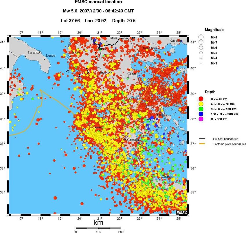
EMSC          Real Time Earthquake Information Services

       2/31
EMSC                                                                                Real Time Earthquake Information Services

                                                Table of content
I. INTRODUCTION ................................................................................................. 5
II. REAL TIME DATA AND REAL TIME EARTHQUAKE INFORMATION
SERVICES ................................................................................................................. 7
II.1. DATA DESCRIPTION AND PROCESSING .................................................... 7
   II.1.1.          DATA DESCRIPTION........................................................................................ 7
   II.1.2.          QWIDS: An actual real time communication system ..................................... 7
   II.1.2.1.          General features........................................................................................... 7
   II.1.2.2.          Configuration................................................................................................ 7
   II.1.2.3.          Firewall issues.............................................................................................. 8
   II.1.3.          MESSAGES PROCESSING .............................................................................. 8
   II.1.4.          STRATEGY TO ASSIGN A LOCATION TO AN EVENT ................................... 9
        II.1.4.1. Event reported by one network.................................................................................. 9
        II.1.4.2. Event reported by several networks.......................................................................... 9
            II.1.4.2.1. Automatic locations............................................................................................... 9
            II.1.4.2.2. Manual locations ................................................................................................. 10
            II.1.4.2.3. Case of redundant phases.................................................................................. 10
II.2.      REAL TIME EARTHQUAKE INFORMATION SERVICES ............................ 11
   II.2.1.          PUBLISHED INFORMATION ...........................................................................11
        II.2.1.1. EMSC web site ........................................................................................................... 11
            II.2.1.1.1. “For Seismologist only” and “Public” pages ........................................................ 11
            II.2.1.1.2. Information associated to each event ................................................................. 13
            II.2.1.1.3. Moment tensors solutions................................................................................... 16
            II.2.1.1.4. Quick Mw values provided by other institutes .................................................... 16
            II.2.1.1.5. Special web pages.............................................................................................. 17
            II.2.1.1.6. Seismicity maps, Google tools............................................................................ 17
            II.2.1.1.7. Members section ................................................................................................ 17
        II.2.1.2. Imode and WAP pages.............................................................................................. 17
   II.2.2.          DISSEMINATED INFORMATION .....................................................................18
        II.2.2.1. Earthquake Notification Service .............................................................................. 18
            II.2.2.1.1. Principle .............................................................................................................. 18
            II.2.2.1.2. Criteria to disseminate a notification................................................................... 18
            II.2.2.1.3. Dissemination in alert mode ............................................................................... 19
            II.2.2.1.4. Notification definitions and formats..................................................................... 19
            II.2.2.1.5. Evolution of the ENS early 2006......................................................................... 22
            II.2.2.1.6. Role of the IGN ................................................................................................... 22
            II.2.2.1.7. A specific alert system: EUR-OPA agreement ................................................... 22
        II.2.2.2. RSS feed ..................................................................................................................... 22
        II.2.2.3. Widget for real time seismic information................................................................ 22
        II.2.2.4. AutoDRM .................................................................................................................... 22
   II.2.3.          COLLECTION OF IN-SITU INFORMATION .....................................................24
        II.2.3.1.      Felt maps: Area where the earthquake has potentially been felt ......................... 24
        II.2.3.2.      Online macroseismic questionnaire........................................................................ 25
        II.2.3.3.      Intensity maps: A damage assessment using testimonies .................................. 25
        II.2.3.4.      Pictures: Actual damage caused by the earthquake ............................................. 26
III. APPENDIX A: REAL TIME CONTRIBUTORS IN 2008 ................................ 27
IV.  APPENDIX B: EMSC MEMBERS IN 2008.................................................... 29
V. REFERENCES .................................................................................................. 31

                                                                      3/31
EMSC          Real Time Earthquake Information Services

       4/31
EMSC                                                     Real Time Earthquake Information Services

I. INTRODUCTION
The European Mediterranean Seismological Center (EMSC) is an international NGO which members
are seismological institutes and observatories of the Euro-Med region (Appendix C) and hosted since
1992 by the LDG (Laboratoire de Détection et de Géophysique, France). Its main scientific activities
are the Real Time Earthquake Information (RTEI) services and the production of the Euro-Med Bulletin
(Godey et al.).

The RTEI services are operating thanks to the operational technical support of the LDG by compiling
the real time parametric data provided, received by email and provided by 66 seismological networks.
EMSC provides several services in the field of rapid information on the European-Mediterranean
seismicity and significant earthquakes worldwide.

                                               5/31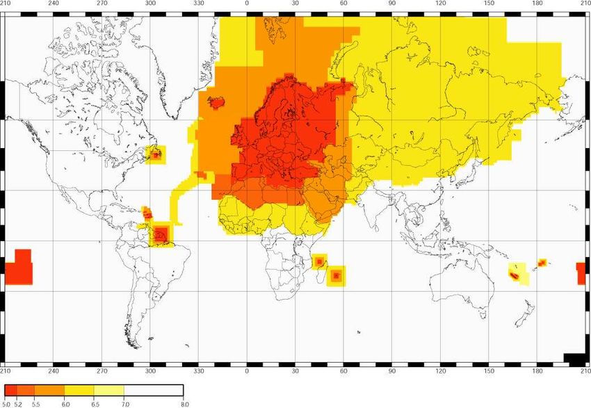
EMSC          Real Time Earthquake Information Services

       6/31
EMSC                                                      Real Time Earthquake Information Services

II. REAL TIME DATA AND REAL TIME EARTHQUAKE
    INFORMATION SERVICES
    II.1.   DATA DESCRIPTION AND PROCESSING
        II.1.1. DATA DESCRIPTION
The Real Time Earthquake Information services are based on the reception, by email or via QWIDS
(see §II.1.2), of parametric data (source parameters, phase pickings, amplitudes) provided by 66 data
contributors (i.e. seismological networks) (Appendix A). Some data contributors send their data
automatically and very shortly (few minutes) after the earthquake occurrence. For others, the data are
sent by the person on duty. Some agencies provide data during working hours only.

The messages sent by the data contributors contain different types of data:
   • Source parameters (origin time, epicenter location, focal depth, magnitude).
   • Phase pickings (station code, arrival times, phase type, amplitudes and periods). Some
      messages only contain a group of phase pickings without any associated location.
   • Moment tensors solutions, Focal mechanisms.

        II.1.2. QWIDS: An actual real time communication system
In order to improve its performances and especially the speed and robustness of the reception of real
time data, EMSC implemented a software named QWIDS (Quake Watch Information Distribution
System) which has been developed by ISTI (Instrumental Software Technologies Inc.;
http://www.isti.com/) and has been kindly provided by the U.S. Geological Survey. QWIDS provides a
quick and robust data exchange system through permanent TCP connections. At the difference with
emails that can sometimes be delayed or lost, QWIDS is an actual real time communication system
that ensures the data delivery.

            II.1.2.1.   General features
QWIDS uses a server-client technology in which the information published by the server is
immediately pushed (via CORBA methods), in xml format, to the connected clients. For this, a
permanent TCP/IP connexion through 2 dedicated ports must be established between the server and
the client.

Its performances show that it is able to push a single message to 1000 connected clients within 1.4
seconds.

QWIDS is a free (for non-commercial purposes) and open-source software developed in java and is
therefore multi-platform. It also provides security features (user authorization + message
authentication), a high level of configurability, a persistent archiving of messages, and a message
recovery system which allows the client to catching up the missed messages during the period of time
it has been down.

            II.1.2.2.   Configuration
QWIDS can be configured in a way to provide redundancy and scalability. In a typical configuration,
several QWIDS Servers are permanently connected to the Data Providers (Figure 1). As soon as a
Data Provider publishes new data, they are immediately pushed to the connected Servers. As a
consequence the Servers that are connected to the same Data Providers receive the same data at the
same time. Each Client is also permanently connected to both Servers (Figure 1) which provides
redundancy in the collection and dissemination of data. Indeed, in such a configuration, in case of
failure of Server 1, the client will receive automatically the data through Server 2.

                                                7/31
EMSC                                                                  Real Time Earthquake Information Services

                              Data                Data                Data             Data
                             Provider            Provider            Provider         Provider

                                 EIDS server                            EIDS server
                                    N°1                                    N°2

                    EIDS                EIDS                EIDS           EIDS           EIDS
                    Client              Client              Client         Client         Client

                              Figure 1: Typical architecture of QWIDS components

Other servers can also be added and even direct Server-Server connections can also be established
to further improve the redundancy.

Currently, the NEIC and ORFEUS are both providing real time data to EMSC via QWIDS. Two QWIDS
Relay servers are operated respectively at EMSC and ORFEUS.

            II.1.2.3.    Firewall issues
In a typical connection, a server and a client communicate through 2 dedicated ports: one for the data
transfer and one for the notification service. For security reasons, these ports are generally chosen
greater than 1024 (n° 38977 and 38988 by default). It is thus important to have in mind the difficulties
that may be encountered on the server or client side while opening the ports through the different
routers/firewalls that may be involved.

ISTI has also developed a client which runs through web services (port 80 (http) or 443 (https)) and
therefore does not require any extra port opening however this solution does not provide the same
quality of service.

        II.1.3. MESSAGES PROCESSING
Here after is presented how the data are processed, how EMSC computes locations and the rules
used to assign a location to an event. In this part, the word “message” refers to email messages that
contain source parameters/phase pickings information.

The mailbox is checked every minute and every incoming message is processed following the same
procedure:
    • Identification of the network which provides the data.
    • Conversion of the data into GSE2.0 format.
    • Conversion of local station codes into international ones.
    • Archiving into an Oracle database which makes the data available through an autoDRM
       (Figure 2).
    • Discard events with magnitude lower than 2.0 for further processing. If no magnitude has been
       reported, the message is kept for further processing.
    • Association to the group of messages previously received (i.e. from other networks) for the
       same event.

                                                            8/31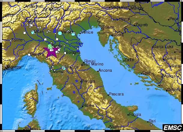
EMSC                                                                                      Real Time Earthquake Information Services

                                Net.            Net.           Net.          Net.         Net.          Net.             Net.

                                 Oracle                                                                        “For seismologist only”
                                 database                                                                            web page

                          AutoDRM (GSE2.0)

                                                Earthquake
                                                                      Authoritativeness          Automatic
                                             Notification Service                                                      Emails
                                                   (Manual)                (QDM)                 Locations

                        Fax, Email, SMS
                              End users:                                                                   Additional Data
                         Eur. CPU, OCHA, ECHO,
                         MSF, Council of Europe,                       Public web page,                   (moment tensors,
                        NATO, IFRC, etc., a dozen                     Imode, WAP, RSS                    field observations,
                           of rescue teams and
                              7,453 individuals
                                                                                                        damage reports, etc.)

                                                       Public Information           Data collection from the public
                                                                                           (macroseismic
                                                                                      questionnaires, pictures)

                    Figure 2: Data flow for the Real Time Earthquake Information services

        II.1.4. STRATEGY TO ASSIGN A LOCATION TO AN EVENT

            II.1.4.1.        Event reported by one network
A geographical region defined as a polygon is associated to each network. An earthquake reported by
this network and which location falls within this region is considered as reliable. One says the network
is authoritative in the region. For example, the French national network is authoritative in France and
border regions. A software named QDM (Quake Data Merge), provided by the U.S. Geological Survey
(written by A. Jones and D. Oppenheimer) is plied to determine the authoritativeness of the network in
the region of event occurrence.

When an event is reported by only one network, its location is assigned to the event only if this
network is authoritative in the region of occurrence.

            II.1.4.2.        Event reported by several networks
When an event is reported by several networks, EMSC performs a location by merging and
associating the phase pickings provided by the different networks. The location is assigned to this
event. These locations can be either automatically or manually (by EMSC staff or the seismologist on
call) computed.

                II.1.4.2.1.                   Automatic locations
An automatic location is performed as soon as data from several networks are available for the same
event. Then, when new data coming from another network is made available, the location is updated
by integrating the new phase pickings.

Automatic locations are computed thanks to a program called Fusion provided by the LDG (EMSC
host institute). The result of an automatic location is disseminated 65 minutes after the event
occurrence to a list of seismological institutes. Some use them to trigger automatic moment tensors
computations.

                                                                            9/31
EMSC                                                      Real Time Earthquake Information Services
                II.1.4.2.2.     Manual locations
Afterwards, each automatic location is manually reviewed by a seismologist. For potentially damaging
earthquake, the manual review is performed quickly after the event occurrence in the framework of the
Earthquake Notification Service (Part II.2.1.) otherwise it is performed in the next hours or the next
working day by EMSC staff or by the seismologist on call.

                II.1.4.2.3.     Case of redundant phases
Because of transnational data exchange and the development of virtual networks, the same seismic
station recording may be used and reported by several networks but with different phase pickings.
One has then to select one pick among the whole list during the location process. Therefore, in each
location performed by EMSC, the following rules are applied:
     • A manual pick replaces the automatic one (for the same station and same phase type) as long
         as its time residual is lower than the automatic pick.
     • A pick to which an amplitude is associated replaces the one without amplitude (as it brings
         additional information) as long as its residual is lower than the one without amplitude.

                                                10/31
EMSC Real Time Earthquake Information Services
II.2. REAL TIME EARTHQUAKE INFORMATION SERVICES
Thanks to the real time data received from the data contributors and the different successive
processing, EMSC provides several real time services, among which information published on a web
site or active dissemination of seismological information such as the Earthquake Notification Service
or the autoDRM.
II.2.1. PUBLISHED INFORMATION
This part presents all the information available on the web site, the Imode and the WAP pages.
II.2.1.1. EMSC web site
The EMSC web site is accessible at the following URL: http://www.emsc-csem.org. It gathers several
real time services described below.
II.2.1.1.1. “For Seismologist only” and “Public” pages
II.2.1.1.1.1. The “For Seismologist Only” web page
This page is dedicated to the seismological community and displays groups of messages that refer to
the same event (Figure 3). All the messages received from the data contributors and which magnitude
exceeds 2.0 (as long as a magnitude is reported) are published on a web page called “For
Seismologist Only (FSO)” page (http://www.emsc-csem.org/index.php?page=current&sub=msg).
II.2.1.1.1.2. The “Public” web page
Because the FSO page is more dedicated to the seismologist community and because it may be
difficult to understand by the general public, the “Public page” has been developed late 2004 and in
order to show a single set of source parameters per event. As a result, a list of latest earthquakes is
available through the Public page (http://www.emsc-csem.org/index.php?page=current&sub=list). It is
updated each minute and presents for each event its associated source parameters: origin time,
epicenter coordinates, focal depth, magnitude type and value, region of occurrence and the time when
the location of the event has been updated (Figure 4).
11/31EMSC Real Time Earthquake Information Services
Figure 3: Extract of the "For Seismologists Only" web page
Figure 4: Extract of the public web page.
12/31EMSC Real Time Earthquake Information Services
II.2.1.1.2. Information associated to each event
For each event reported on the public page, the following information is available:
• Source parameters: Origin time (in UTC), epicenter location, focal depth, magnitude and
region of occurrence. Since mid-October 2006, the name of the geographical regions which
rd
appear on the public page are defined following the 3 level of Flinn-Engdahl regionalization
(J. B. Young et al.; 1996), defined by Bruce Presgrave (USGS). The main improvement from
nd rd
2 to the 3 level of regionalization is that the latter fits the political border which is crucial to
correctly assign a region to an epicenter.
• Distances from epicenter to nearby cities + local time in these cities when the event occurred
(Figure 5).
Figure 5: Source parameters of the event. Distance to nearby cities and local time of occurrence of the
event in these cities.
• Links to networks which provided data for this event and links to regional seismological
institutes where more information on the event may be available.
• Three epicenter views at global, regional and local scales + a Satellite Google Map centered
on the region (Figure 6).
• List of regional deadly earthquakes from 1500 to 2000 (Utsu; 2002) (Figure 7).
• Moment tensors solutions provided by the different institutes (Figure 8).
• Past focal mechanisms in the region (Figure 9). Source: EMMA database (Vanucci et al.;
2004).
• Maps of regional instrumental seismicity (Figure 10). Source: 1964-2001 ISC catalog.
13/31EMSC Real Time Earthquake Information Services
Figure 6: Snapshot of the different maps generated for each event reported on the public page
Figure 7: List of regional deadly earthquakes since 1500
14/31EMSC Real Time Earthquake Information Services
Figure 8: Moment tensors solutions provided by different institutes for the same event
Figure 9: Map of past focal mechanisms
15/31EMSC Real Time Earthquake Information Services
Figure 10: Regional instrumental seismicity maps (Source ISC catalog: 1964-2001)
II.2.1.1.3. Moment tensors solutions
EMSC receives moment tensors (MT) solutions from 12 institutes listed below. For each event, all the
available MT solutions are plotted on the same map (Figure 8):
AUTH: Department of Geophysics, University of Thessaloniki, Thessaloniki, Greece
CPPT: Centre Polynésien de Prévention des Tsunamis, French Polynesia
ERD: Earthquake Research Department, Ankara, Turkey
ETH: Swiss Federal Institute of Technology, Zurich, Switzerland
HARVARD: Seismological group of Harvard University.
IGN: Instituto Geografico Nacional, Madrid, Spain
INGV: Istituto Nazionale di Geofisica e Vulcanologia, Roma, Italy
IPGP: Institut de Physique du Globe de Paris, Paris, France
KOERI: Kandilli Observatory and Earthquake Research Institute, Istanbul, Turkey
NOA: National Observatory of Athens, Geodynamic Institute, Athens, Greece
UPSL: University of Patras. Seismological Laboratory, Patras, Greece
USGS: U.S. Geological Survey, Denver, USA
A web page gathers all MT solutions received until now (i.e. for all events and from the different
agencies): http://www.emsc-csem.org/index.php?page=current&sub=qmt
II.2.1.1.4. Quick Mw values provided by other institutes
EMSC also receives quick Mw values from three institutes which are extremely useful to quickly and
reliably assess the magnitude of large events:
- Via the Tsunami Bulletin Board, EMSC receives the bulletins of the Pacific Tsunami Warning
Center which contain rapid determinations of Mw magnitudes above 6.5, for events of the
Pacific or Indian Oceans or in the Caribbean. These bulletins are quickly issued after
earthquake occurrence and revised if necessary.
- The Japanese Meteorological Agency which provides quick Mw estimations for events in the
Pacific Ocean.
- The Centre Polynésien de Prévention des Tsunamis in French Polynesia provides quick Mw
estimations for events in the Pacific Ocean.
16/31EMSC Real Time Earthquake Information Services
II.2.1.1.5. Special web pages
When an event raises a particular interest and/or causes significant damage (Indonesia (Sumatra)
26/12/2004, Pakistan 08/10/2005, Azores Cape Saint Vincent Ridge 12/02/2007, Chile (Antofagasta)
17/1/2007, etc.), EMSC publishes a special web page gathering additional information such as
aftershocks distribution, field observations, damage reports, moment tensors solutions, macroseismic
questionnaires results, preliminary source studies, etc.
II.2.1.1.6. Seismicity maps, Google tools
In order to represent the current seismic activity in different regions of the world, EMSC gives the
possibility to display the seismic activity of the last 30 days in 6 different regions: Worldwide, Euro-Med
region, North America, South America, Africa/Indian Ocean, Pacific Ocean. The seismicity can be
animated day by day.
EMSC web site also allows to download a kmz file (to be viewed on GoogleEarth) which contains the
last 2 weeks of seismic activity through the following link:
http://www.emsc-csem.org/index.php?page=current&sub=ge
II.2.1.1.7. Members section
In December 2006, a specific web page has been opened on EMSC web to provide specific
information at the attention of EMSC members. Its access is restricted. It proposes services such as
macroseismic questionnaire results, maps of expected Peak Ground Acceleration (PGA) and Peak
Ground Velocity (PGV) (Akkar et al., 2007), number of inhabitants, a discussion forum, the list
1
preliminary information for events processed in the framework of the Earthquake Notification Service
2
(Part II.2.) and the feltmaps .
II.2.1.2. Imode and WAP pages
The Real Time Seismicity is also available in Imode (http://www.emsc-csem.org/rts_imode.html) and
WAP (http://www.emsc-csem.org/rts_wap.wml) for events with magnitude larger than 4.0. This permits
viewing the current world seismic activity on a cell phone or on a PDA.
1
The preliminary information is the first information published on the public page for a given seismic event. It may be either the
location provided by the authoritative network or the EMSC automatic location depending which is available first.
2
The felt maps are generated thanks to the increase of traffic on EMSC web site consecutive to events that have been felt by
the population. By locating the additional visitors thanks to their IP in the first minutes following the earthquake occurrence, it is
possible to map the area where the event has been felt. The way feltmaps are generated is not described in this report.
17/31EMSC Real Time Earthquake Information Services
II.2.2. DISSEMINATED INFORMATION
Apart from the web-based services, EMSC operates seismic information dissemination services like
the Earthquake Notification Service (for potentially damaging earthquakes), the RSS feed and the
autoDRM.
II.2.2.1. Earthquake Notification Service
II.2.2.1.1. Principle
For potentially damaging earthquakes, EMSC operates an Earthquake Notification Service (ENS)
which is operational 24/7. It consists in quickly notifying the end-users who subscribed to this service
of the event occurrence, by fax (restricted to the operational organizations), email or SMS. The
determination of the event source parameters and the dissemination of the message to the end-users
are done manually by the seismologist on call for EMSC.
The subscription to this service can be done through the web site at: http://www.emsc-
csem.org/index.php?page=receive&sub=email. The end-users of the ENS are ECHO (Humanitarian
Aid Agency of the EU), OCHA (Humanitarian Aid Agency of the UN), the Council of Europe, the
European Civil Protection Unit, the EADRCC (Euro-Atlantic Disaster Reaction and Coordination
Centre, NATO), MSF (Médecins sans Frontières), IFRC (International Federation of Red Cross and
Red Crescent) a dozen of rescue teams and several thousands of individuals.
II.2.2.1.2. Criteria to disseminate a notification
II.2.2.1.2.1. Definition of local magnitude thresholds
A set of magnitude thresholds has been defined for events which are processed in the framework of
the Earthquake Notification Service (Figure 11). These magnitude thresholds are:
• 5.0 in Europe
• 5.2 in Northern Africa and Azores region
• 5.5 in Arabic Peninsula, Iran, Caucasus, Caspian region and a part of Northern Atlantic Ocean
• 6.0 in Russia and Continental Asia and Sub-Saharan Africa
• Spanning from 5.0 to 6.5 in areas around the French overseas territories.
• 7.0 in the rest of the world
II.2.2.1.2.2. Alert triggering
As soon as either the authoritative network or two non-authoritative networks report a magnitude that
exceeds the local threshold for the same event, the seismologist on call is warned via phone calls. He
immediately locates the event by merging all the available data, refines the location and disseminates
the notification to the end-users.
18/31EMSC Real Time Earthquake Information Services
Figure 11: Local magnitude thresholds for the Earthquake Notification Service
II.2.2.1.3. Dissemination in alert mode
If the magnitude computed by the seismologist on call for the processed event exceeds the local
magnitude threshold (Figure 11), the event is processed in alert mode. This means that the notification
must be disseminated in less than 1 hour after the earthquake occurrence (generally in 20-40 minutes
for Euro-Med events). The objectives of this rapid dissemination are:
• To give redundancy to alerts systems operated by national institutes.
• To ensure the information outside the affected country(ies).
• To provide reliable locations in border regions and off shore.
• To provide a unique source of information for European and International organizations.
II.2.2.1.4. Notification definitions and formats
While subscribing at the Earthquake Notification Service, the user can define up to two geographical
regions for which he wants to receive the notifications. It is also possible to choose between four
formats to receive the notifications defined as follows:
1. SMS
This format is very concise and is adapted to the reception of messages on a cell phone or on
a PDA. It contains the main characteristics of the event: origin time, epicenter location, focal
depth and distance to a nearby city (Figure 12).
28/06/2006 21:02
Magnitude 5.7
SOUTHERN IRAN
Latitude 27.04 North
Longitude 55.81 East
Depth 35 kilometers
49 km SW Bandar-e 'Abbas
Figure 12: Example of message disseminated by EMSC in SMS format
19/31EMSC Real Time Earthquake Information Services
2. Standard
This format is dedicated to the general public and contains information such as distances to
several nearby cities, population and local time at these cities when the event occurred and
links to regional seismological institutes (Figure 13).
3. Advanced
This format is mainly dedicated to the scientific community and contains additional
seismological information (Figure 14).
4. Pickings
This format is restricted to the seismological community. It adds to the Advanced format the
phase pickings used in the location process.
EMSC earthquake notification
Magnitude 5.7 28/06/2006 21:02 SOUTHERN IRAN
These parameters are preliminary and subject to revisions.
For updates, please consult: http://www.emsc-csem.org
A magnitude 5.7 earthquake has occurred SOUTHERN IRAN at:
27.04N 55.81E Depth 35km 28/06/2006 at 21:02:12 (Universal Time)
Earthquake location with respect to nearby cities:
49 km SW Bandar-e 'Abbas (pop 317946, local time 01:32)
40 km W Qeshm (pop 16691, local time 01:02)
Comments :
Manual location disseminated on 28/06/2006 21:35 (UTC)
EMSC cannot guarantee the receipt or timeliness of an e-mail after
sending.
For maps and additional data, please consult:
http://www.emsc-csem.org
Links to regional seismological observatories:
http://www.iiees.ac.ir/english/index_e.asp
http://irsc.ut.ac.ir
http://www.bhrc.ac.ir/
This location has been computed thanks to the data provided by the
following seismological institutes:
BEO BRA BUC GFZ INGV LDG LED LJU NEIA SED THR
See the full list of data providers at:
http://www.emsc-csem.org/index.php?page=current&sub=contrib
This EMSC service is jointly operated by the LDG (Laboratoire de
Détection et de Géophysique, Bruyères-le-Châtel, France) and the
IGN (Instituto Geografico Nacional, Madrid, Spain).
Subscribe/Unsubscribe/Modifications, please consult:
http://www.emsc-csem.org/index.php?page=receive&sub=email
Figure 13: Example of message disseminated by EMSC in Standard format
20/31EMSC Real Time Earthquake Information Services
Centre Sismologique Euro-Mediterraneen
European-Mediterranean Seismological Centre
Rapid Determination of Source Parameters
operated at LDG (Paris) and IGN (Madrid)
*********************************************************************
*********************** ALERT MESSAGE ****************************
*********************************************************************
WARNING : These parameters are preliminary and subject to revision.
Location and magnitude estimations may be revised if necessary in
an INFORMATION message.
_____________________________________________________________________
EARTHQUAKE on 28/06/2006 at 21:02 (UTC)
SOUTHERN IRAN 7 km E Pahel
MAGNITUDE: mb 5.7
Data provided by: BEO BRA BUC GFZ INGV LDG LED LJU NEIC NEWS
NOR SED THR
Latitude = 27.04 N
Longitude = 55.81 E
Origin Time = 21:02:12.4 (UTC)
Depth = 35 Km
RMS = 1.14 sec
Gap = 57 degrees
95% confidence ellipse: - Semi major = 7.5 Km
- Semi minor = 4.6 Km
- Azimuth of major axis = 10 degrees
Number of data used = 337
Preliminary location computed on Wed Jun 28 21:35:43 2006 (UTC)
Done by Julien VERGOZ
Comments :
Message number: 733
All magnitudes estimations :
mb5.6 (BEO) mb5.7 (BRA) Ms5.4 (BUC) mb5.8 (GFZ)
mb5.4 (INGV) mb5.7 (LDG) mb5.3 (LED) mb5.8 (NEIC)
mb4.8 (NEWS) mb5.2 (NOR) mb6.0 (SED) ML5.4 (THR)
Figure 14: Example of message disseminated by EMSC in Advanced format
21/31EMSC Real Time Earthquake Information Services
II.2.2.1.5. Evolution of the ENS early 2006
The Earthquake Notification Service has been upgraded on 11/01/2006 in order to give to the end-
users the possibility to receive earthquake information for a specific geographic area and from a
minimum magnitude. Before that, each manually reviewed location was sent to the whole list of end-
users in the Advanced (Figure 14) or Pickings formats. Moreover, a distinction was made between the
earthquakes for which the magnitude exceeds the local threshold and the others. Therefore, in the
current service, the Advanced and Pickings formats still use this distinction:
• Alert message: if the magnitude of the event is higher than or equal to the local threshold.
• Information message: if the event raises a particular interest and/or if it is widely felt but its
magnitude is lower than the local threshold.
• Revision message: sent as revisions of the initial messages (may be Alert or Information
message) for significant variations of one of the source parameters (location, depth, or
magnitude). Revisions messages are often used for large events for which the magnitude is
generally difficult to estimate within the first hour. For minor revisions, the update is published
on the web page only. The notion of Revision is also used for the Standard and SMS format.
II.2.2.1.6. Role of the IGN
When EMSC is not able to operate the Earthquake Notification Service, the IGN (Instituto Geografico
Nacional, Madrid, Spain) is in charge of it. This occurs for example during maintenance intervention at
or outside EMSC (internet service providers, electric backbone …) which may disturb the data
processing although the real time services may remain on line during the intervention. However, the
IGN operates this service in a degraded mode in which each earthquake notification is sent to all end-
users.
II.2.2.1.7. A specific alert system: EUR-OPA agreement
EMSC also provides a specific alert system for the Council of Europe for events with magnitude larger
than 6.0 in one of the countries which have signed the EUR-OPA (Open Partial Agreement on Major
Hazards) agreement: Albania, Algeria, Armenia, Azerbaijan, Belgium, Bulgaria, Cyprus, Spain,
France, Georgia, Greece, Italy, Lebanon, Luxembourg, FYR of Macedonia, Malta, Moldova, Morocco,
Monaco, Portugal, San-Marino, Romania, Russia, Turkey, Ukraine.
II.2.2.2. RSS feed
RSS feeds are commonly used for frequently updated web pages. Users of RSS feeds use programs
called feed readers or aggregators which can check the feeds to see if it has new content since the
last time it checked. If so, it retrieves the content and presents it to the user.
A RSS feed for the real time seismic activity has been opened in December 2006 (http://www.emsc-
csem.org/rss.php). As a difference with the public web page, the RSS feed does not display the EMSC
automatic locations.
II.2.2.3. Widget for real time seismic information
In October 2007, EMSC developed a widget that allows viewing the last Euro-Med and worldwide
events on a map that is updated automatically and that can be added to a personal web portal such as
Google Desktop, Igoogle or Netvibes.
II.2.2.4. AutoDRM
As explained before, the messages received from the data contributors are all included into an Oracle
database. The content of this database is available by autoDRM (Automatic Data Request Manager)
to the users who subscribed to it (Subscription at http://www.emsc-
csem.org/index.php?page=data&sub=register). The autoDRM sends data back to the user in GSE2.0
format.
22/31EMSC Real Time Earthquake Information Services
There are 2 ways to use the autoDRM, either by filling a web form (http://www.emsc-
csem.org/index.php?page=data&sub=request_rts&db=rts) or by sending a formatted email to EMSC
which is automatically processed (Figure 15).
Figure 15: Example of autoDRM request
23/31EMSC Real Time Earthquake Information Services
II.2.3. COLLECTION OF IN-SITU INFORMATION
In order to complement its services of rapid earthquake information, EMSC developed a number of
tools to rapidly collect in-situ observations of the earthquake effects and better evaluate the reaction of
the population. Here below is presented how peaks of web traffic are used to generate felt maps
(Bossu at al, 2008), as well as a few examples of intensity maps and pictures received from the
witnesses.
II.2.3.1. Felt maps: Area where the earthquake has potentially
been felt
The felt map tool is an original EMSC development. It uses the observed surge of traffic on EMSC web
site (Figure 16) to rapidly (within 5 to 10 minutes of the earthquake’s occurrence) map the area where
an earthquake has been felt and to determine whether there has been significant widespread damage.
When an earthquake is felt, people rush to the Internet to find out the cause of the shaking, generating
brutal surge of traffic on EMSC web site. The area where the earthquake was felt is determined by
locating the IP addresses and identifying the localities which exhibit a significant increase of visitors
(Bossu at al, 2008).
Figure 16: Typical surge of web traffic on EMSC web site after a felt earthquake
Figure 17: Felt map generated 4 minutes after the Mw 5.4 event in Northern Italy on 23/12/2008 at 15:24 UTC.
24/31EMSC Real Time Earthquake Information Services
II.2.3.2. Online macroseismic questionnaire
Since July 2006, a macroseismic questionnaire is available on EMSC web site for people who wish to
report their experience after an earthquake. The goal of collecting macroseismic questionnaires is first
to characterize the effects of earthquakes on people, objects and structures. Eventually, the results of
the questionnaires can be used to compute intensities and to plot macroseismic intensity maps.
The questionnaire was initially available in English but thanks to the help of EMSC members and data
contributors, it has been translated in 20 languages (at the time of this report) and is now available in
Albanian, Arabic, Armenian, Bulgarian, Croatian, Dutch, English, Farsi, French, German, Greek,
Hungarian, Montenegrin, Polish, Portuguese, Romanian, Russian, Slovakian, Spanish and Turkish
(Figure 18). The results of the questionnaires are available for EMSC members in the dedicated
Members section of the web site.
Before filling the questionnaire, the visitor selects the event felt. An online help is provided to people
who can not identify the event they have felt in the list of latest events. The visitor then determines the
place (country + administrative subdivision + city) where the observation was made. This information
is crucial in order to be able afterwards to associate a macroseismic intensity with an observation. For
this, a database of 145,504 cities worldwide is used to help the observer to determine accurately the
place of the observations. The exact postal address of the user is also collected (though optional) as it
can be useful to the national institutes in charge of producing intensity maps to locate the observations
with more accuracy.
The procedures to compute intensities are currently in development at EMSC in collaboration with the
BGS (British Geological Survey, Edinburgh, UK) and the ETHZ (Eidgenössische Technische
Hochschule, Zürich, Switzerland).
Figure 18: Snapshot of the links proposed to the web users to access the macroseismic questionnaire
II.2.3.3. Intensity maps: A damage assessment using
testimonies
Since April 2008, intensity maps are computed and updated automatically upon reception of new
questionnaires. Intensities are expressed in EMS-98 scale. An intensity can be assigned to a location
only if at least 5 questionnaires are available for this location (Colored dots on Figure 19-20).
Otherwise a default intensity (Felt) is assigned (White dots on Figure 19-20).
Figure 19: Intensity map generated after the Mw6.4 Figure 20: Intensity map generated after the Mw 5.4
event near Patras, Greece on 08/06/2008 at 12:25 event in Northern Italy on 23/12/2008 at 15:24 UTC.
UTC. Legends on Figure 21 Legends on Figure 21
25/31EMSC Real Time Earthquake Information Services
Figure 21: Legends for Intensity maps
Testimonies give the actual level of shaking at a given site but they also confirm what has been
observed on the felt map. Indeed, the felt maps and the intensity maps for Italian event (Figure 17 and
20) reproduce more or less the same pattern.
II.2.3.4. Pictures: Actual damage caused by the earthquake
Witnesses have the opportunity to share their pictures of the damage. Once validated by a
seismologist, they are published on EMSC web site. This proves valuable to provide local constraints
on the actual damage but also to document the earthquake phenomenon. Rare pictures have already
been collected as in Greece (Figure 22). Collected pictures are made available through the web site.
A tutorial available on the web site explains how to provide pictures (by email, by MMS or by direct file
upload) and how to link the file to the right seismic event. However, so far no picture has been
received via MMS probably because it is not free of charge for the sender.
Figure 22: Rock falls in Porto Katsiki, Lafkada Islands, Greece caused by the shake after the Mw6.4 event near
Patras, Greece on 08/06/2008 at 12:25 UTC.
26/31EMSC Real Time Earthquake Information Services
III. APPENDIX A: REAL TIME CONTRIBUTORS IN 2008
CODE INSTITUTE TYPE COUNTRY
BEO Seismological Survey of Serbia, Beograd OP Serbia
BER University of Bergen, Bergen OP Norway
BGR Bundesanstalt für Geowissenschaften und Rohstoffe, Hannover & Erlangen OPA Germany
BGS British Geological Survey, Edinburgh OPA United-Kingdom
BGSG British Geological Survey, Global network (EarlyBird system), Edinburgh OP United-Kingdom
BRA Seismology Division, Slovak Academy of Sciences, Bratislava OPA Slovakia
BUC National Institute for Earth Physics, Bucharest OP Romania
CNRM Centre National de la Recherche Scientifique et Technique, Geophysics Laboratory, Rabat OP Morocco
CRAA Centre de Recherche en Astronomie, Astrophysique et Géophysique, Algiers OP Algeria
CYP Geological Survey Department, Nicosia OP Cyprus
DDA Earthquake Research Department, Ministry of Public Works and Settlement, Ankara OP Turkey
DHMR National Seismological Observatory Centre, Dhamar OPA Yemen
DJI Observatoire Géophysique d'Arta, Arta OP Djibouti
GFU Geophysical Institute of Academy of Sciences, Prague OP Czech Republic
GFZ GeoForschungsZentrum (GEOFON), Potsdam OPA Germany
GII Seismology Division, Geophysical Institute of Israel, Tel Aviv OP Israel
GRAL National Center for Geophysical Research, Beirut OP Lebanon
GSRC Geophysical Survey. Russian Academy of Sciences, Obninsk OP Russia
HSNC Technological Educational Institute of Crete, Seismological Network of Crete P Greece
ICC Instituto Cartografico de Catalunya, Barcelona OP Spain
IGUT Institute of Geophysics, University of Tehran, Tehran OPA Iran
IMO Department of Geophysics, Icelandic Meteorological Office, Reykjavik OP Iceland
IMP Instituto de Meteorologia, Seismologia, Lisbon OPA Portugal
INGV Italian National Seismic Network, Roma OPA Italy
INMT Institut National de la Météorologie, Tunis OP Tunisia
IRSA Romanian Institute for Applied Seismology, Bucharest OP Romania
ISN Iraqi Meteorological Organization and Seismology, Bagdad OP Iraq
JSO Jordan Seismological Observatory, Amman OP Jordan
KAN Kandilli Observatory and Earthquake Research Institute, Istanbul OP Turkey
LDG Laboratoire de Détection et de Géophysique, Bruyères-le-Châtel OPA France
LED Landsamt für Geologie, Rohstoffe und Bergbau, Baden Württemberg OP Germany
LJU Environmental Agency of the Republic of Slovenia, Seismological Office, Ljubljana OP Slovenia
LVV Carpathian Seismological Dept., Ukraine Academy of Science, Lviv P Ukraine
MAD Instituto Geografico Nacional, Madrid OPA Spain
MCSM Ukrainian NDC, Main Center of Special Monitoring, Kiev P Ukraine
MOLD Institute of Geophysics and Geology, Chisinau P Moldova
MON Direction de l'Environnement, de l'Urbanisme et de la Construction P Monaco
MSO Montenegro Seismological Observatory, Podgorica OPA Montenegro
NEIR USGS/NEIC, Denver OPA USA
NEWS Norwegian Seismic Array, Kjeller OPA Norway
NNC Kazakhstan National Data Center, Institute of Geophysical Research, Almaty OP Kazakhstan
NOA National Observatory of Athens, Geodynamic Institute, Athens OPA Greece
NOR Norwegian Seismic Array, Kjeller OPA Norway
NRIA National Research Institute of Astronomy and Geophysics, Cairo OP Egypt
NSSP National Survey of Seismic Protection, Yerevan OP Armenia
ODC Observatories and Research Facilities for EUropean Seismology, De Bilt OP The Netherlands
OGS Osservatorio Geofisico Sperimentale, Trieste OP Italy
PDA Instituto de Meteorologia, Azores University, Ponta Delgada, Azores OP Portugal
RNS Réseau National de Surveillance Sismique, Strasbourg OP France
RSSC Azerbaijan National Academy of Sciences, Baku OP Azerbaijan
SASN South African Seismological Network, Pretoria OP South Africa
SED Swiss Seismological Service, Zurich OP Switzerland
SGS Saudi Geological Survey, Jeddah OP Saudi Arabia
SKO Seismological Observatory of Skopje, Skopje OPA Macedonia
SOF Bulgarian Academy of Science, Bulgarian Academy of Sciences, Sofia OP Bulgaria
SNSN Swedish National Seismological Network, Uppsala OP Sweden
SPGM Département de Physique du Globe, Rabat OP Morocco
THE Department of Geophysics, University of Thessaloniki, Thessaloniki OP Greece
27/31EMSC Real Time Earthquake Information Services
THR International Institute of Earthquake Engineering and Seismology, Tehran OP Iran
TIF Georgian National Survey of Seismic Defense, Tbilisi OP Georgia
TIR Institute of Seismology, Academy of Sciences, Tirana OP Albania
UCC Royal Observatory of Belgium, Brussels OP Belgium
UPSL University of Patras, Seismological Laboratory, Patras OP Greece
WAR Institute of Geophysics, Polish Academy of Sciences OPA Poland
ZAG Seismological Survey, University of Zagreb, Zagreb OP Croatia
ZAMG ZentralAnstalt für Meteorologie und Geodynamik, Vienna OP Austria
Appendix A: Seismological networks that have provided real time parametric data to EMSC in 2008 (in
orange: new contribution). Legends: O: Source parameters; P: Phase pickings; A: Amplitudes.
28/31EMSC Real Time Earthquake Information Services
IV. APPENDIX B: EMSC MEMBERS IN 2008
Key Nodal Members Country Contact
Laboratoire de Détection et de Géophysique (LDG) France Dr. B. FEIGNIER
GeoForschungsZentrum (GFZ) Germany Dr. W. HANKA
Istituto Nazionale di Geofisica e Vulcanologia (INGV) Italy, Roma Dr. M. OLIVIERI
Istituto Nazionale di Geofisica e Vulcanologia (INGV) Italy, Milano Dr. P. ALBINI
Dr. E. CARRENO
Instituto Geografico Nacional (IGN) Spain
HERRERO
Active Members
Seismological Institute (ASN) Albania Dr. E. DUSHI
Centre de Recherche en Astronomie, Astrophysique et Géophysique (CRAAG) Algeria Dr. K. YELLES
National Seismological Center (NSC) Armenia Dr. A. Sh. ANTONYAN
Central Institute for Meteorology and Geodynamics (ZAMG) Austria Dr. W. LENHARDT
Republican Seismic Survey Center of Azerbaijan National Academy of
Azerbaijan Dr. V. FARAJOV
Sciences (RSSC)
Center of Geophysical Monitoring Belarus Dr. A. G. ARONOV
Observatoire Royal de Belgique (ORB) Belgium Dr. F. COLLIN
Republic Hydrometeorological Institute (RHI) Bosnia-Herzegovina Prof. D. TRKULJA
Federal Meteorological Institute (FMI) Bosnia-Herzegovina Dr. I. BRLEK
Bulgarian Academy of Sciences Bulgaria Dr. E. BOTEV
A. Mohorovicic Geophysical Institute and Croatian Seismological Survey (AMGI
Croatia Dr. M. HERAK
& CSS)
Geological Survey Department (GSD) Cyprus Dr. P. MICHAELIDES
Institute of Physics of the Earth, Brno (IPE) Czech Republic Dr. J. SVANCARA
Geophysical Institute of the Academy of Sciences (GFU) Czech Republic Dr. J. ZEDNIK
National Survey and Cadastre Denmark Dr. S. GREGERSEN
Observatoire Géophysique d’Arta (DJI) Djibouti M. K. MOHAMMED
National Research Institute of Astronomy and Geophysics (NRIAG) Egypt Prof. ABUO EL ELA AMIN
Institute of Seismology (ISF) Finland Dr. P. HEIKKINEN
Bureau Central de Sismologie Français (BCSF) France Dr. M. GRANET
Bureau de Recherches Géologiques et Minières (BRGM) France Dr. P. DOMINIQUE
Laboratoire Central des Ponts et Chaussées (LCPC) France Dr. P.-Y. BARD
Bureau of Seismic Risk Evaluation for the Safety of Nuclear Facilities
France Dr. D. BEAUMONT
(BERSSIN)
Laboratoire de Géophysique Interne et de Tectonophysique France Dr. F. COTTON
Institute of Geophysics (TIF) Georgia Prof. T. CHELIDZE
BGR Seismological Observatory Graefenberg (BGR) Germany Dr. K. KLINGE
National Observatory of Athens (NOA) Greece Dr. K. MAKROPOULOS
University of Thessaloniki (AUTH) Greece Dr. E. SCORDILIS
Institute of Engineering Seismology and Earthquake Engineering (ITSAK) Greece Dr. C. PAPAIOANNOU
Laboratory of Seismology, University of Patras (UPSL) Greece Prof. A. TSELENTIS
Icelandic Meteorological Office (IMO) Iceland Dr. S. JACOBSDOTTIR
Dublin Institute for Advanced Studies (DIAS) Ireland Prof. P. READMAN
Geophysical Institute of Israel (GII) Israel Dr. Y. GITTERMAN
National Data Center (NDC) of Israel, Soreq Nuclear Research Center Israel Dr. Y. BEN HORIN
Istituto Nazionale di Oceanografia e Geofisica Sperimentale (OGS) Italy Dr. E. PRIOLO
Storia Geofisica Ambiente srl (SGA) Italy Dr. E. GUIDOBONI
Jordan Seismological Observatory (JSO) Jordan Dr. T. AL-YAZJEEN
Seismological Institute of Kosovo (SIK) Kosovo M. N. HASI
Geophysics Centre at Bhannes (SGB) Lebanon Dr. A. SURSOCK
Libyan Center for Remote Sensing and Space Science (LCRSSS) Libya Dr. H. GASHUT
European Center for Geodynamics and Seismology (ECGS) Luxembourg M. E. BUTTINI
Seismological Observatory Macedonia Dr. L. PEKEVSKI
Physics Department, University of Malta (PDUM) Malta Dr. P. GALEA
Academy of Sciences of Republic of Moldova Moldova Dr. V. ALCAZ
Direction Environnement Urbanisme et Construction (DEUC) Monaco Dr. P. MONDIELLI
29/31EMSC Real Time Earthquake Information Services
Montenegro Seismological Observatory (MSO) Montenegro Dr. B. GLAVATOVIC
Centre National de la Recherche (CNR) Morocco Prof. A. I. IBRAHIM
Département de Physique du Globe Morocco Pr. B. A. TADILI
University of Bergen (BER) Norway Dr. J. HAVSKOV
Norwegian Seismic Array (NORSAR) Norway Dr. J. SCHWEITZER
Institute of Geophysics, Polish Academy of Sciences (IGPAS) Poland Dr. W. DEBSKI
Instituto de Meteorologia (IMP) Portugal Dr. F. CARRIHLO
Instituto Superior Tecnico (IST) Portugal Dr. J. FONSECA
Universidade de Evora Portugal Dr. M. BEZZEGHOUD
Universidade de Lisboa (UL) Portugal Dr. J. M. A. DE MIRANDA
National Institute for Earth Physics (NIEP) Romania Dr. G. MARMUREANU
Bucharest Seismic Alert Centre (BSAC) Romania M. A. AILENEI
Geological Survey of the Russian Academy of Sciences (GSRAS) Russia Dr. A. MALOVICHKO
Center of Geophysical Computer Data Studies (CGDS) Russia Dr. A. GVISHIANI
King Abdulaziz City for Sciences and Technology (KACST) Saudi Arabia Dr. T. AL-KHALIFAH
Seismological Survey of Serbia (SSS) Serbia Dr. S. RADOVANOVIC
Geophysical Institute, Department of Seismology Slovakia Dr. P. LABAK
Geophysical Survey of Slovenia (ARSO) Slovenia Dr. I. CECIC
Institut Geologic de Catalunya (IGC) Spain Dr. A. ROCA
Real Instituto y Observatorio de la Armada (ROA) Spain D. J. M. DAVILA
Universidad Politecnica de Madrid (UPM) Spain Dr. B. BENITO
Swedish National Seismic Network (SNSN) Sweden Dr. R. BODVARSSON
Schweizerischer Erdbebendienst (ETH) Switzerland Dr. F. HASLINGER
Royal Netherlands Meteorological Institute (KNMI) The Netherlands Dr. R. SLEEMAN
Institut National de la Météorologie (INMT) Tunisia Dr. M. RAJHI
Earthquake Research Department (ERD) Turkey Dr. Y. IRAVUL
Kandilli Observatory and Earthquake Research Institute (KOERI) Turkey Prof. G. BARBAROSOGLU
Main Center for Special Monitoring (MCSM) Ukraine M. I. KACHALIN
Dubai Municipality UAE M. Y. A. ALMARZOOQI
British Geological Survey (BGS) United Kingdom Dr. B. BAPTIE
National Seismological Observatory Centre (NSOC) Yemen Dr. J. SHOLAN
Members by Right
European Seismological Commission (ESC) Dr. M. GARCIA
Observatories and Research Facilities for EUropean Seismology (ORFEUS) Dr. B. DOST
International Seismological center (ISC) Dr. D. STORCHAK
U.S. Geological Survey (USGS) Dr. S. SIPKIN
Appendix C: List of 2007 EMSC members (in orange: new memberships in 2008)
30/31EMSC Real Time Earthquake Information Services
V. REFERENCES
Godey S., Bossu R., Guilbert J., Mazet-Roux G. The Euro-Mediterranean Bulletin: A comprehensive
seismological Bulletin at regional scale. Seismological Research Letters 77 (4), 460-474
Young J.B., Presgrave B. W., Aichele H., Wiens D.A., Flinn E.A. The Flinn-Engdahl Regionalisation
scheme: the 1995 revision. Physics of the Earth and Planetary Interiors 96 (1996) 223-297
Utsu T. A List of Deadly Earthquakes in the World: 1500-2000. International Handbook of Earthquake
and Engineering Seismology. Vol. 81A (2002) 691-718
Vanucci G., Gasperini P. The new release of the database of Earthquake Mechanisms of the
Mediteranean Area (EMMA Version 2). Annals of Geophysics Supplement to Vol. 47, N. (2004) 307-
334
Bossu R., Internet Users as Seismic Sensors for Improved Earthquake Response. EOS, Transactions,
AGU, Vol. 89, No. 25, 225-226
31/31You can also read