Environmental Impact Report - Doughill Forest Property Doughill 5-year management plan (2017-2021) - Coillte
←
→
Page content transcription
If your browser does not render page correctly, please read the page content below
Environmental Impact Report
      Doughill Forest Property

        Doughill 5-year management plan (2017-2021)

                                                              January, 2017

  Corresponding author: Dr Dermot Tiernan, Coillte Forest | Coillte, Cedar House, Moneen
  Road, Castlebar, Co Mayo, Ireland.

                                             1
Table of contents
EXECUTIVE SUMMARY OF KEY MITIGATIONS ............................................................................ 3

1.      SCOPE............................................................................................................................................... 4

  1.1 GUIDING PRINCIPLES ............................................................................................................................ 4

2.      THE MANAGEMENT CONTEXT.................................................................................................. 5

  2.1 WATER ON SITE .................................................................................................................................... 5
  2.2 SOIL TYPES........................................................................................................................................... 7
  2.3 AGE PROFILE ........................................................................................................................................ 8
  2.4 STABILITY ............................................................................................................................................ 9
  2.5 OPPORTUNITIES & CONSTRAINTS ....................................................................................................... 11

3.      THE OPERATIONAL SCHEDULE ............................................................................................ 13

  3.1 THE HARVEST SCHEDULE .................................................................................................................... 13
  3.2 THE RESTOCKING SCHEDULE.............................................................................................................. 15
  3.3 BROADLEAF PLANTING ........................................................................................................................ 17
  3.4 LANDSCAPE DESIGN............................................................................................................................ 18
  3.5 THE ROADING SCHEDULE ................................................................................................................... 19

4.      OVERVIEW OF THE ENVIRONMENTAL ASSESSMENT .................................................. 20

  4.1 COILLTE ERA SCREENING ................................................................................................................... 21
  4.2 THE ERA SCREENING RESULTS FOR THE 5 YEAR PLAN......................................................................... 24
  4.3 WINDFARM MITIGATIONS .................................................................................................................... 26
  4.4 STANDARD OPERATIONAL MITIGATIONS .............................................................................................. 33
  4.5 SITE SPECIFIC MITIGATIONS ............................................................................................................... 34

5.      SITE MONITORING ................................................................................................................... 35

  5.1 DAILY SITE MONITORING .................................................................................................................... 35
  5.2 WEEKLY SITE MONITORING ................................................................................................................. 36
  5.3 MONTHLY WATER SAMPLING................................................................................................................ 36

6.      EMERGENCY PLANNING .......................................................................................................... 38

  6.1 POLLUTION CONTROL PROCEDURE - SPILLS ......................................................................................... 38
  6.2 THE EMERGENCY PLAN ....................................................................................................................... 40
  6.3 FLOODING RISKS ................................................................................................................................ 42

7.      CONSULTATION ......................................................................................................................... 43

  7.1 CONSULTATION FOR DOUGHILL PROPERTY .......................................................................................... 43

APPENDIX A: EXAMPLES OF THE SITE SPECIFIC OPERATIONAL MAPS......................... 47

APPENDIX B – STANDARD MITIGATIONS .................................................................................. 49

APPENDIX C: SITE MONITORING FORMS ................................................................................... 53

                                                                                    2
Executive summary of key mitigations
The measures needed for the sustainable management of the forest stands in
Doughill, following the windfarm development, are detailed in this operational
environmental impact report. The following is a summary of the key mitigation
measures that will be applied during the period 2017 to 2021.
Key mitigation measures
The traditional practice of tendering out individual sales to a suite of
harvesting contractors will be replaced with a tender for one dedicated
contractor to manage all the sales.
A suite of standard mitigations that reflect good forest management practices
apply and are a condition of the awarded tender for both harvesting and
restocking operations.
The implementation of the additional site specific environmental mitigations
specified in this report will be conditional on the award of all tenders.
The mitigation measures associated with the windfarm development will be
retained and linked in with the forest management mitigations.
All watercourses (EPA streams, relevant watercourses and field drains),
associated crossing points and silt trap locations are identified on each
operational map on a site-specific basis.
Water flows and silt will be controlled high up in the catchment by the
installation of new silt traps strategically located on field drains.
The majority of harvested sites will be windrowed, which does not involve any
ground disturbance. This is a significant water flow and silt control measure.
Mounding if used will be confined to a limited number of mostly flat sites.
All sites will be monitored on a daily basis by the contractor, on a weekly
basis by Coillte personnel and these will be validated fortnightly by
independent water sampling from the key water exit points from the
property.
Restock plans will result in creating new buffer zones and standard setbacks.
Each site has a detailed site specific plan with all site specific mitigations
clearly shown on each operational map.
All sites were subject to an environmental screening process.
All sites with listed archaeological monuments will be subject to a detailed site
assessment that will inform the appropriate mitigations to adopt on site.
With the exception of 2 sales, no thinning will be scheduled in the property
before 2021 to help minimise the windthrow risk.
No new roads will be made during the planning period.
3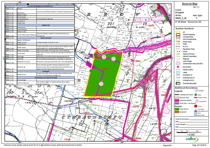
1. Scope
This document outlines the impact and associated mitigation measures for all
planned high impact operations in the Doughill property for the period 2017 to
2021. These mitigation measures are necessary to ensure that protection is
afforded to soils and water, people and material assets, biodiversity, landscape,
archaeology and cultural heritage and mitigate against the threat of windthrow.
High impact operations relate to all operations that involve any degree of ground
disturbance and relate to roading, harvesting and restocking activities. This
assessment will place specific emphasis on the protection of soils and water & public
consultation. All relevant mitigation measures specified in this report will be
implemented on a site-by-site basis with all relevant mitigations detailed on the
operational map supplied to the contractor. These operational maps are provided in
Appendix A.
1.1 Guiding principles
The guiding principles for this environmental assessment is compliance with the
Principles of Sustainable Forestry Management (SFM) which involves managing our
business in full compliance with all applicable laws, directives, Forest Service
guidelines and regulations, as well as voluntary external accredited schemes to
which we subscribe such as the Forest Stewardship Council®¹ (FSC®) and the
Programme for the Endorsement of Forest Certification (PEFC™). The purpose of
these guiding principles is to prevent negative environmental impacts through a
system of advance planning, operational controls that include clear communication,
written instructions and appropriate training. The following list of documents are
some of the key documents used:
Forest Service: Forest operations and Water Protection Guidelines 2000;
Forest Service: Forest Harvesting and the Environment Guidelines 2000;
Forest Service: Forestry and the Landscape Guidelines 2000;
Coillte Forest: Operations and Water Protection Guidelines 2013;
The COFORD Forest Roads Manual 2004.
IFI Guidelines 2009 – Shannon Regional Fisheries board, Protection &
Conservation of fisheries habitat.
¹FSC licence code FSC- C005714
4
2. The management context

 The guiding principles for this environmental assessment is compliance with the
 principles of Sustainable Forestry Management (SFM) which involves managing our
 business in full compliance with all applicable laws and directives. The management
 context for the 5-year management plan for the Doughill property will be discussed
 in detail in the following key areas:

    (a) Water on site

    (b) Soil types

    (c) Age profile

    (d) Stability

    (e) Opportunities & Constraints

                                              Figure 1: Schematic overview of the
                                              management context.

2.1 Water on site

 The management of water quality on site is a priority for this property. All forestry
 activities have the potential to interact both positively and negatively on water
 quality, however with careful planning any potential negative impacts can be
 mitigated against through good forest practice and targeted mitigation measures.
 To help understand how water is managed in Doughill, it is important to distinguish
 between the different types of water courses using the standard definitions below.

  Catchment: An area of land defined by topography and hydrological flow
  patterns, which drain into a river.

  A EPA stream/aquatic zone: A natural feature defined as a permanent or
  seasonal river, stream or lake shown on an Ordnance Survey 6” map.

  An aquatic zone: A permanent or seasonal river, stream or lake shown on an
  Ordnance Survey 6 inch map.

  A relevant watercourse: is defined as any channel not shown on a 6 inch OS
  map, that is directly connected to an aquatic zone.

  A Drain: A man-made channel that generally does not require a buffer zone.

                                          5
Doughill, for the purpose of this report, is considered to be water sensitive and is
managed as such. The site is in two catchments (Upper Shannon and Lough Ree)
and these are sub-divided into smaller sub catchments. In total there are eight EPA
streams draining the site and these flow into the Scramoge River and the Feorish
Rivers, which are both tributaries of the River Shannon. The Scramoge & Feorish
Rivers are important trout and coarse fisheries.

The management of water quality is primarily aimed at mitigating against
sedimentation, nutrient enrichment and fuel spillages, which are defined below.

a) Sedimentation, where particles of silt are washed into the stream or river
   (watercourse) and clog the finer gravel bed thus depriving hatching trout and
   salmon and other river fauna of free movement, resulting in oxygen deprivation
   and mortality.

b) Nutrient enrichment (otherwise known as eutrophication), where nutrients -
   mainly phosphorous in the case of forestry - are washed into the watercourse and
   enrich water quality thus encouraging algal and weed growth. This can lead to a
   reduced oxygen supply to salmonids and other aquatic organisms, causing
   mortality of stream fauna. Eutrophication is predominantly an issue of concern on
   peat soils, particularly where the depth of peat is in excess of 30 cm.

c) Fuel spillages of diesel or oil are also a potential source of contamination and
   this must be considered in planning the detailed site operation and have
   contingency measures in place in the event of a spill.

                                         6
2.2 Soil types

 As shown in Figure 2 the predominant soil type is a mineral gley soil, ranging from
 a shallow gley (in green) to a deep mineral gley (in brown). These soils are very
 fertile and have a high clay and moisture content making them highly productive
 from a forestry perspective. Gley soils are prone to siltation (where the clay
 particles are easily suspended in water). Silt from gley soils poses a threat to
 watercourses because of its potential to come out of suspension and settle on
 stream beds and damage fish spawning areas. However, while silt from gley soils
 goes into suspension easily in water (and silts up the water) it also comes out of
 suspension easily and as a result, with effective planning using buffer zones and silt
 traps, this form of siltation can be easily controlled at source and prevented from
 reaching the spawning beds. In Doughill, numerous measures are taken to ensure
 all silt mobilisation events are retained at source.

      Figure 2: The location of the deep and shallow gley soils in Doughill.

                                           7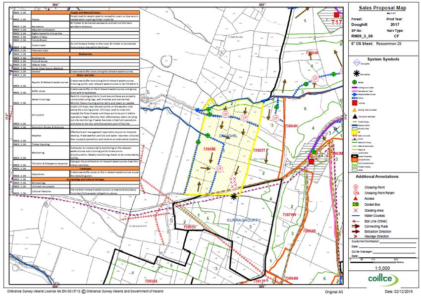
2.3 Age profile

 Doughill forest property contains 784 ha of productive forest stands. As shown in
 Figure 3, Doughill is a mature forest plantation with 68% (538 ha) of the property
 over 20 years of age and 32% (246 ha) under 20 years of age.

                            The age profile for Doughill property

                                      40 plus, 19.9, 2%
                                                                       0 to 10 years old,
          30 to 40 years                                                    52.7, 7%
          old, 103.5, 13%

                                                                                10 to 20 years
                                                                                old, 193.3, 25%

                                           20 to 30 years
                                           old, 414.2, 53%

        0 to 10 years old    10 to 20 years old   20 to 30 years old      30 to 40 years old   40 plus

      Figure 3: The age profile for Doughill property (September 2016).

                                                      8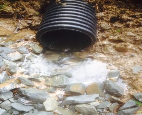
2.4 Stability

 Crop stability refers the ability of forest crops to remain standing during its rotation.
 Windblow occurs when the force of the wind is greater than the ability of the tree to
 resist the winds force, resulting in the tree(s) blowing over. Generally, windblown
 crops are to be avoided from both a health and safety and economic perspective. In
 terms of safety, windblown crops present considerable challenges when harvesting
 the crop with most of the lethal forest accidents occurring in windblown stands.
 Economically, there is a loss in terms of timber quality resulting from breakages
 and also the added cost to harvest and manage and these areas safety.
 Consequently, avoiding windblow is standard forest management practice. In Coillte,
 stability ratings are used to describe the stability capacity of stands. These stability
 ratings are typically S18, S21 and S24, which corresponds to the crop remaining
 stable until it reaches a height of 18m, 21m and 24m respectively. Once these
 crops grow beyond these heights the incidence of windblow is expected to increase.
 Historically, Doughill property was managed with a stability rating of 21m and this
 will remain unchanged.

 In Ireland, windfirm crops generally are located in sheltered parts of the country, in
 low lying areas on soils that facilitate deep rooting depths. Historically, windthrow
 has occurred in Doughill. While Doughill is located in a relatively sheltered part of
 Ireland, it is also situated on an exposed mountain with gley soils that have shallow
 rooting depths. In addition, the construction of the windfarm has created new
 openings in a semi-mature crop to allow for the windfarm footprint and widened
 roads. The combined effect is an expected reduction in wind firmness of the current
 crop. Consequently, a stability rating of S21m applies to the whole property. This
 effectively means that stands are expected to grow to 21m in height with no
 windthrow expected but if allowed to grow beyond 21m the chances of windthrow
 are expected to increase significantly. As Doughill is a very productive forest with
 fast growth rates, this stability concern was built into the rotation lengths for all
 stands to ensure crops are not grown into the risk period when they grow beyond
 21m. This will ensure that windblow events are minimised.

 While the construction of the windfarm is expected to reduce the wind firmness of
 the current crop, it may actually increase the wind firmness of the successor crop.
 This is a result of the way tree roots grow and mature in plantation forests. Tree
 root growth occurs in the early years of the trees growth and they will grow into all
 the available space to them. Typically, tree roots on plantation edges have more
 room to grow and their roots are well developed and produce trees capable of
 resisting strong wind forces. Conversely, tree roots within plantations have less
 room to grow and their roots are not as well developed as those on the edges,
 resulting in trees that are not as effective at resisting strong wind forces. The
 windfarm construction has imposed new roads and openings within mostly semi-
 mature plantations where no further root development will occur. As a result, trees
 that were within the plantation with tree roots suitable for within a planation are
 now on an exposed edge, making them susceptible to windthrow. However, once
 the current rotation is felled and restocked the replanted trees will develop tree
                                            9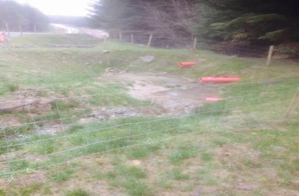
roots produce trees capable of resisting strong wind forces all along the new roads
and openings created by the windfarm development, resulting in an expected
improvement in the overall stability for the successor crop.

    Windblow in Doughill in crops under 20m in height

    (December 2016)

                                        10
2.5 Opportunities & Constraints
As expected there is a diverse range of opportunities and constraints associated
with the management of Doughill forest property. Table 1 lists some of the main
opportunities and constraints associated with the 5 year management plan.
Table 1: The opportunities and constraints associated with the 5 year
management plan.
People & Material Assets
Opportunities Constraints
Open forest policy allowing full access to the Access needed all year round to avail of
Coillte lands. recreation opportunities.
Purpose built new recreation trail in place Maintenance of recreation facilities required
annually.
Well-developed road network throughout the Temporary closure of routes or diversions
site. maybe required from time to time for safety
purposes during operations.
Conduct a local consultation meeting to Consultation to be informed of the
discuss plan and invite feedback. management challenges present on site.
Water & Soils
Detailed water controls in place as part of the Saturated gley soils are not efficient at
windfarm construction will remain in place post absorbing additional rainfall and run-off during
construction. downpours will occur. To mitigate for this
additional operational controls are required.
Water sampling points in place and regular Water sampling costly to carry out.
water sampling will continue for the next 5
years.
All of site is a mineral gley which produces a Gley soils are generally not effectively drained
type of sediment that can be controlled using conventional drainage ditches.
effectively using good practice.
Water drainage plan in place to deal with peak Gley soils are prone to rutting especially in wet
water flow events. weather
All of the site is suitable for windrowing which The creation of new buffer zones will require
is very effective at containing siltation during limited machine movements in these buffers to
restocking operations. ensure all mature trees are harvested and
brash removed.
11Archaeology & Cultural Heritage
Known archaeological monuments well Exclusion zones required around all
documented and protected on site monuments.
Townland boundaries well defined on the Townland boundaries should not be crossed
ground running along either streams or large with heavy machinery where practical.
ditches
New recreation trails ensure all local heritage Application of standard setbacks will result in
sites are accessible and preserved. the loss of existing productive forest ground.
Biodiversity
A mature plantation can be redesigned at The creation of new buffer zones results in the
restock stage to include greater buffer zones loss of productive ground for commercial
planted with broadleaves along the main forestry.
watercourses.
Targeted planting of broadleaves when Planted broadleaves will need additional
restocking. protection from grazing threats from both deer
and goats.
Existing biodiversity areas are known and The biodiversity on site is limited and of
protected and can be enhanced at replanting moderate ecological value.
stage.
Landscape
Due to the improved road network a mature Coupe redesign must comply with Health &
plantation can be redesigned at restocking Safety concerns and ensure access and egress
stage to create more effective buffer zones, over the windfarm underground cable is via a
irregular coupe shapes and improved species designated properly constructed crossing
diversity. point.
Nestle the windfarm development within a Impact on increasing the threat of wind throw
forest property to minimise the visual impact resulting from opening up the canopy mid-
on the landscape. rotation
Implementation of the agreed biodiversity plan Landscape rated as having a medium
can begin. landscape rating by Coillte.
Only approximately 50% of the property is Approximately 50% of the property can be
visible from the R371(Strokestown to viewed at any one time from one of 2 county
Lanesborough) road. roads.
123. The Operational schedule
The operational schedule for 2017 – 2021 detailed below relates to all high impact
operations that involves any degree of ground disturbance. The operational
schedules detailed below refer to three different schedules, namely the harvesting
schedule, the restocking schedule and the roading schedule.
3.1 The harvest schedule
The harvest schedule for both clearfelling and thinning is detailed below in Table 2
and Figure 4 for the planning period 2017 to 2021. This table and map shows the
harvest block number, the harvest type as either a clearfell or a thinning, the year
of the planned activity and the associated areas.
Table 2: The harvest schedule for the period 2017 – 2021.
Number Harvest Block CF or Thin Harvest Year Area (ha)
1 RN09_2_01 Thin 2017 9.9
2 RN09_3_01 CF 2017 0.8
3 RN09_3_02 CF 2017 7.0
4 RN09_3_03 CF 2017 5.9
5 RN09_3_05 CF 2017 11.0
6 RN09_3_06 CF 2017 12.3
7 RN09_3_07 CF 2017 12.3
8 RN09_3_08 CF 2017 17.9
9 RN09_3_09 CF 2017 20.7
10 RN09_4_01 CF 2017 8.5
11 RN09_5_01 CF 2018 4.3
12 RN09_5_03 CF 2018 13.7
13 RN09_5_05 CF 2018 19.2
14 RN09_5_06 CF 2018 21.0
15 RN09_H00092 Thin 2018 21.8
16 RN09_4_01 CF 2019 8.5
17 RN09_HB0011 CF 2019 14.7
18 RN09_HB0029 CF 2019 12.0
19 RN09_HB0044 CF 2019 6.5
20 RN09_HB0049 CF 2019 9.4
21 RN09_HB0059 CF 2019 4.1
22 RN09_HB0060 CF 2019 4.8
23 RN09_HB0062 CF 2019 11.1
24 RN09_HB0063 CF 2019 6.5
25 RN09_HB0065 CF 2019 3.4
26 RN09_HB0075 CF 2019 4.1
27 RN09_HB0084 CF 2019 4.0
28 RN09_HB0017 CF 2020 18.1
29 RN09_HB0028 CF 2020 4.7
30 RN09_HB0066 CF 2020 2.1
31 RN09_HB0071 CF 2020 8.6
32 RN09_HB0024 CF 2021 5.5
33 RN09_HB0027 CF 2021 4.5
34 RN09_HB0038 CF 2021 9.9
35 RN09_HB0039 CF 2021 9.9
13Figure 4: Overview of the harvest schedule for 2017-2021.
143.2 The restocking schedule
The restocking schedule for all sites harvested during the period 2017 to 2021 is
detailed below in Table 3. This table shows that all harvested sites will be replanted
within one calendar year of harvesting. As this forest property is a commercial
forest, the replanting schedule will be with primarily Sitka spruce and the dominant
cultivation method will be windrowing. All sites will be operated to the standard
operational standards and subject to the site specific mitigations.
The restocking schedule outlined in Table 3 does not include the replanting
obligations associated with the “reinstatement area” resulting from the windfarm
development. This reinstated area refers to approximately 23ha of Coillte Forest
stands that were felled as part of the windfarm development to facilitate erection of
the turbines on the condition that they would be replanted immediately post
construction. As a result, all of this area will be replanted in 2017 post construction
in accordance with the felling licence conditions and planning regulations. As this
replanting is associated with the windfarm it is not included in the restocking
schedule as outlined in table 3.
The restocking schedule outlined in Table 3 does not include values for open space.
Typically open space values range from 5 – 15 % and this will also apply to
schedule in Table 3.
15Table 3: The restocking schedule for sites harvested during the period 2017–2021.
Harvest Harvest Restock Species Species Species Area
% Area % Area % Area
Block Year Year 1 2 3 (ha)
RN09_2_01 2017 NA NA NA NA NA NA NA NA NA NA NA
RN09_3_01 2017 2018 BI 100 0.8 0.8
RN09_3_02 2017 2018 SS 95 6.7 Oak 5 0.4 7.0
RN09_3_03 2017 2018 SS 90 5.3 Oak 10 0.6 5.9
RN09_3_05 2017 2018 SS 95 10.5 Oak 5 0.6 11.0
RN09_3_06 2017 2018 SS 95 11.7 Oak 5 0.6 12.3
RN09_3_07 2017 2018 SS 95 11.7 Oak 5 0.6 12.3
RN09_3_08 2017 2018 SS 95 17.0 Oak 5 0.9 17.9
RN09_3_09 2017 2018 SS 95 19.7 Oak 5 1.0 20.7
RN09_HB0002 2017 2018 SS 90 8.7 Oak 10 1.0 9.7
Total area 2017 92.0 5.6 97.6
RN09_5_01 2018 2019 SS 95 4.1 Oak 5 0.2 4.3
RN09_5_03 2018 2019 SS 95 13.0 Oak 5 0.7 13.7
RN09_5_05 2018 2019 SS 90 17.3 ROW 5 1.0 SAL 5 1.0 19.2
RN09_5_06 2018 2019 SS 95 20.0 Oak 5 1.1 21.0
RN09_H00092 2018 NA NA NA NA NA NA NA NA NA NA
Total area 2018 54.3 2.9 1.0 58.2
RN09_4_01 2019 2020 SS 100 8.5 8.5
RN09_HB0011 2019 2020 SS 95 14.0 Oak 5 0.7 14.7
RN09_HB0029 2019 2020 SS 95 11.4 Oak 5 0.6 12.0
RN09_HB0044 2019 2020 SS 90 5.9 Oak 10 0.7 6.5
RN09_HB0049 2019 2020 SS 90 8.5 Oak 10 0.9 9.4
RN09_HB0059 2019 2020 SS 95 3.9 Oak 5 0.2 4.1
RN09_HB0060 2019 2020 SS 65 3.1 Bi 20 1.0 Oak 15 0.7 4.8
RN09_HB0062 2019 2020 SS 95 10.5 Oak 5 0.6 11.1
RN09_HB0063 2019 2020 SS 95 6.2 Oak 5 0.3 6.5
RN09_HB0065 2019 2020 SS 95 3.2 Oak 5 0.2 3.4
RN09_HB0075 2019 2020 SS 100 4.1 4.1
RN09_HB0084 2019 2020 SS 95 3.8 Oak 5 0.2 4.0
Total area 2019 83.0 5.3 0.7 89.1
RN09_HB0017 2020 2021 SS 95 17.2 Oak 5 0.9 18.1
RN09_HB0028 2020 2021 SS 95 4.5 Oak 5 0.2 4.7
RN09_HB0066 2020 2021 SS 95 2.0 Oak 5 0.1 2.1
RN09_HB0071 2020 2021 SS 95 8.2 Oak 5 0.4 8.6
Total area 2020 31.8 1.7 33.5
RN09_HB0024 2021 2022 OAK 70 3.9 ROW 20 1.1 HAW 10 0.6 5.5
RN09_HB0027 2021 2022 SS 95 4.3 Oak 5 0.2 4.5
RN09_HB0038 2021 2022 SS 75 7.4 Oak 20 2.0 BI 5 0.5 9.9
RN09_HB0039 2021 2022 SS 95 9.4 Oak 5 0.5 9.9
Total area 2021 25.0 3.8 1.0 29.8
* Open space assumed to be between 5-15% and does not include the windfarm footprint.
163.3 Broadleaf planting
The management plan from 2017-2021 will see an increase in the level of broadleaf
planting in the property using native trees and shrubs as recommended in the
“Native Woodland Scheme” as administered by the Forest Service. Pedunculate oak
will be the favoured broadleaf choice where suitable conditions exist. The planting of
broadleaves will occur throughout the site with particular attention paid to the
recreation areas and areas where suitable ground conditions exist (see Figure 5).
Consequently, broadleaves will be planted into:
All suitable areas in close proximity to the recreation areas;
Aquatic zones where operations are occurring;
New standard setbacks on relevant watercourses and field drains;
Areas adjacent to windmills where reinstatement works are completed;
Areas immediately adjacent to the new recreation route;
Areas adjacent to the stilling and storage ponds;
Other areas, where deemed appropriate.
Figure 5: Breakdown of the expected species planted and open space resulting
from the restocking schedule.
173.4 Landscape design
The planning of the felling coupes was carried out in accordance with the Coillte
landscape design plan for Doughill. All forest properties in the Coillte estate have a
detailed landscape plan that prescribes how best to manage a landscape from a
visual perspective. These principles were included in the five year management plan
and a summary of the main design elements adopted are detailed below in Table 4.
Table 4: The main landscape design elements adopted in 5 year
management plan for Doughill.
Keep block size reduced under Red/BLUE ERA mitigations to enhance
25ha landscape design
Adjusted block shape to improve Structural diversity in the property
visual impact considered when scheduling the block
Planning stage
Block adjusted to follow Thinning not scheduled to improve
opportunities
natural contours and breaks visual impact
Introduce more open space and
structural diversity in large even
aged blocks.
Existing open spaces retained Retain Scrub/broadleaves
Harvest stage
Biodiversity plan adhered to Harvest mitigations specified to avoid
opportunities
rutting
Protect the existing biodiversity
Tree clearance around arch
monuments
Restocking Broadleaf replanting plan in New standard setbacks applied
stage place
opportunities Restock planting design to improve
New buffer zones to be created visual appearance
Site hot planted to speed green
up
Road designed to follow Road density increased to reduce
Roading
contours coupe size
opportunities
No new entrances created Only existing roads to be used
183.5 The roading schedule
All sales in the planning period 2017-2021 are fully roaded. As part of the windfarm
development, the existing road network was upgraded and extended to facilitate
the windfarm development. This development also included the construction of
designated crossing points to allow for safe extraction from the forest over the
underground electric cables. These crossing points also included spur road
extensions, to ensure there is adequate space available during harvesting to stack
timber. As a result of these developments, no further road building will occur during
the planning period and any road activity during this time will be limited to regular
road maintenance.
194. Overview of the environmental assessment
The purpose of this environmental assessment is minimise the environmental
impact for all planned high impact operations for the next 5 years by specifying site
specific mitigations. As shown in Figure 6, the environmental assessment consists
of 4 main elements, namely:
(a) Coillte Environmental Risk Assessment (ERA) screening;
(b) Windfarm mitigations;
(c) Standard operational mitigations;
(d) Site specific mitigations.
Figure 6: Schematic overview of the four elements used in the
environmental assessment.
204.1 Coillte ERA screening
The Coillte Environmental Risk Assessment (ERA) is a procedure that assesses the
potential environmental impacts associated with forest operational activities carried
out by Coillte. Potentially impacting activities include, tree-harvesting, ground
preparation, drainage, construction of roads, bridges, and fertiliser application. The
results of this assessment are colour coded to assist in understanding the
sensitivities involved and as shown in Table 5, these colour codes are:
Blue (sensitive with statutory features);
Red (sensitive with no statutory features);
Amber (potentially sensitive subject to desk review);
Green (not sensitive).
Table 5: The ERA ratings applied during the screening process.
ERA Rating Explanation Examples
Sensitive site (with statutory features) SAC with possible
Annex I habitat
BLUE
Site has a feature which is protected under
national and/or EU legislation Monuments
Sensitive site (with no statutory
Biodiversity area or
features)
old woodland site
RED with many
Site has a feature which is protected under
biodiversity features
Coillte policies or Sustainable Forest
present
management (SFM) Standards
Potentially Sensitive Site Coupes >20ha
AMBER Desk Review required to decide whether Within SAC, pNHA,
site is sensitive or not and a BLUE, RED, or biodiversity area,
GREEN rating is applied as appropriate. old woodland site
Standard mitigations apply
Environmental features may be present but About 80% of Coillte
GREEN
the site is not particularly sensitive; sites
features are protected by applying best
practice
21The environmental risk assessment is carried out on individual sites using five main
categories, namely;
1. People & Material Assets;
2. Water & Soils;
3. Archaeology & Cultural Heritage;
4. Biodiversity;
5. Landscape.
The ERA involves a hierarchical approach which involves three key steps:
Step 1: Auto risk filtering;
Step 2: Desk review;
Step 3: Field assessment.
Step 1: Auto risk filtering
This is an automated GIS query which determines whether the site is potentially
environmentally sensitive or not. This step uses the vast array of GIS datasets and
queries available to prescribe a rating. Sites that given a GREEN rating retain this
as their final rating. Sites that are given an AMBER rating are subject to a desk
review (step 2) so that they can be assigned either a GREEN, RED or BLUE rating.
Sites that are given a BLUE or RED rating are subject to a field assessment (step
4).
Step 2: Desk review
This step only reviews the sites rated as AMBER, with the view to assigning them a
rating as either BLUE, RED or GREEN. This stage involves refining the information
available from step one, by incorporating local knowledge into the decision making
process.
Step 3: Field assessment
Sites rated as BLUE or RED from steps 1 & 2 require a field assessment to identify
significant features present on site and to determine at an early-stage elements of
the site plan that need to be implemented in order to ensure that environmental
risks are prevented or minimised. The site specific management measures are then
22incorporated into the operational site file to ensure that the specified mitigations
are implemented on the ground. For BLUE sites, a detailed report is completed by
the Coillte Environmental Officer (or appropriate qualified person) to specify the site
specific management measures required. For RED sites the site-specific mitigations
are completed by the Coillte Resource manager.
The ERA information provides useful information to manage individual sites
including site assessments, information on the location of sensitive features and
associated management measures. This information is also used to assist in the
felling licence process, where site reports for BLUE sites are submitted to the Forest
Service as part of the felling licence application process. The information is also
provided to the contractors at both the contractor procurement stage and at the
operations stage – this is important since these contractors conduct the site
operations. Providing the information at the procurement stage allows the
contractor to submit an informed tender, while provision of the information at the
operations stage ensures that the required management actions are effectively
communicated to contractors.
As a precautionary measure, a decision was made to carry out field
assessments (step 3) on all sites in the 5-year plan regardless of their
ERA rating. This is to ensure that site-specific mitigations could be
prescribed to inform the tendering process.
234.2 The ERA screening results for the 5 year plan
The operational sites for 2017-2021 were all subjected to this ERA screening
process and the results of these are available in Table 6. The results show that the
majority of the area is not sensitive (GREEN) with only the listed monuments
screening as sensitive (BLUE). These archaeological monuments will be/were
surveyed by an archaeologist and the required mitigations are included in the
operational plan.
Table 6: ERA screening results for harvest blocks 2017 to 2021 for Doughill.
Year Harvest Block Activity Type People & Biodiversity Water & Soils Landscape Archeology
Material Assets
2017 Rn09_2_01 Thinning GREEN GREEN GREEN GREEN GREEN
RN09_3_01 Clearfell GREEN GREEN GREEN GREEN GREEN
RN09_3_02 Clearfell GREEN GREEN GREEN GREEN GREEN
RN09_3_03 Clearfell GREEN GREEN GREEN GREEN GREEN
RN09_3_05 Clearfell GREEN GREEN GREEN GREEN BLUE
RN09_3_06 Clearfell GREEN GREEN GREEN GREEN GREEN
RN09_3_07 Clearfell GREEN GREEN GREEN GREEN GREEN
RN09_3_08 Clearfell GREEN GREEN GREEN GREEN GREEN
RN09_3_09 Clearfell GREEN GREEN GREEN GREEN GREEN
RN09_4_01 Clearfell GREEN GREEN GREEN GREEN GREEN
RN09_HB0002 Clearfell GREEN GREEN GREEN GREEN GREEN
RN09_HB0082 Thinning GREEN GREEN GREEN GREEN GREEN
2018 RN09_5_01 Clearfell GREEN GREEN GREEN GREEN GREEN
RN09_5_03 Clearfell GREEN GREEN BLUE GREEN GREEN
RN09_5_05 Clearfell GREEN GREEN RED GREEN GREEN
RN09_5_06 Clearfell GREEN GREEN GREEN GREEN GREEN
RN09_HB0092 Thinning GREEN GREEN GREEN GREEN BLUE
2019 RN09_HB0011 Clearfell GREEN GREEN GREEN GREEN GREEN
RN09_HB0029 Clearfell GREEN GREEN GREEN GREEN GREEN
RN09_HB0044 Clearfell GREEN GREEN GREEN GREEN GREEN
RN09_HB0049 Clearfell GREEN GREEN GREEN GREEN GREEN
RN09_HB0059 Clearfell GREEN GREEN GREEN GREEN GREEN
RN09_HB0060 Clearfell GREEN GREEN GREEN GREEN GREEN
RN09_HB0062 Clearfell GREEN GREEN GREEN GREEN GREEN
RN09_HB0063 Clearfell GREEN GREEN GREEN GREEN GREEN
RN09_HB0065 Clearfell GREEN GREEN GREEN GREEN GREEN
RN09_HB0075 Clearfell GREEN GREEN GREEN GREEN GREEN
RN09_HB0084 Clearfell GREEN GREEN GREEN GREEN GREEN
2020 RN09_HB0017 Clearfell GREEN GREEN GREEN GREEN GREEN
RN09_HB0028 Clearfell GREEN GREEN GREEN GREEN GREEN
RN09_HB0066 Clearfell GREEN GREEN GREEN GREEN GREEN
RN09_HB0071 Clearfell GREEN GREEN GREEN GREEN BLUE
2021 RN09_HB0024 Clearfell GREEN GREEN GREEN GREEN GREEN
RN09_HB0027 Clearfell GREEN GREEN GREEN GREEN GREEN
RN09_HB0038 Clearfell GREEN GREEN GREEN GREEN BLUE
RN09_HB0039 Clearfell GREEN GREEN GREEN GREEN BLUE
24The ERA results for the five year operational schedule for the 5 year operational
schedule indicate that the overall sensitivity is quite low and that standard
mitigation measures would be satisfactory in the management of the majority of
this area. However, it was decided that all sites in this plan be treated as sensitive
so that both standard and site-specific mitigations could be specified. Consequently,
a detailed site assessment was conducted on all sites to identify the most
appropriate site-specific measures to adopt. This site assessment involved the
following criteria, which in turn were used to create the site-specific mitigations:
Identify all watercourses and distinguish between streams, relevant
watercourses and field drains;
Specify crossing point locations over all watercourses to ensure these are
kept to a minimum ;
Identify the optimal location of new silt trap locations;
Identify the preferred extraction direction;
Specify the crossing points over the underground cable;
Identify the stacking area on roadside;
Locate the service areas at least 50m away from all watercourses;
Identify the location of all listed monuments;
Specify the location and width of all new buffer zones to be created at
restock stage,
Prescribe new broadleaf planting in suitable locations;
Identify where new setbacks are to created;
Identify potential hotspots where additional brash management is required;
Locate any blown material;
Specify the preferred haulage route.
254.3 Windfarm mitigations
The development of the windfarm has resulted in the construction of long term
mitigation installations that will be beneficial to the management of the forest
property. These windfarm mitigations include:
a) Windfarm Drainage Management Plan;
b) Windfarm water monitoring;
c) Windfarm Environmental incident & Emergency response plan;
d) Windfarm Recreational improvements.
a) Windfarm Drainage Management Plan
The wind farm footprint was designed so that only one stream crossing was
required. Natural routes of watercourses were maintained, with no diversion of
existing watercourses occurring. A detailed drainage management plan was put in
place as part of the windfarm development. The key elements of this plan included
design and control elements to control flow velocities and peak flow volumes as
follows:
There is no direct discharge to natural watercourses.
Silt traps and check dams installed at regular intervals along drains in order
to reduce flow velocities and therefore minimise erosion within the system
during storm rainfall events.
Stilling ponds, emplaced either singly or a pair in series, will buffer volumes
of runoff discharging from the drainage system during periods of high
rainfall, by retaining water until the storm hydrograph has receded, thus
reducing the hydraulic loading to watercourses. Stilling ponds designed to
retain the volume associated with a 1 in 100 year return period rainfall
event, with overspill for higher events, with retention times of 24 hours at
the borrow pit.
Buffered Outfalls constructed at the end of each settlement pond to convert
channel flows in the drain into diffuse sheet flow to be discharged across the
vegetation filter.
A buffer zone of 50m will be in place for streams including three main
streams as identified by Inland Fisheries Ireland.
26Analysis has indicated that additional runoff from the site will be insignificant.
However, as a precautionary measure, additional design and control measures were
also employed to control peak flow volumes and suspended sediment releases.
These additional measures are as follows:
Mound drain collectors installed up-gradient of works areas to collect surface runoff,
in order to maintain the existing flow regime and to divert unaffected runoff from the
development footprint. It will then be directed to areas where it can be re-distributed
over the ground as sheet flow.
Drains used to intercept and collect runoff from works areas of the site, and channel
it to stilling ponds for sediment settling.
Check dams installed at regular intervals along interceptor drains and drains in order
to reduce flow velocities and therefore minimise erosion within the system during
storm rainfall events. The check dams can result in settlement of suspended
sediment, although this is not their primary function.
Stilling ponds, emplaced as pairs in series, buffer volumes of runoff discharging from
the drainage system during periods of high rainfall, by retaining water until the storm
hydrograph has receded, thus reducing the hydraulic loading to watercourses. Stilling
ponds have been designed to retain the volume associated with a 1 in 100 year
return period rainfall event, with overspill for higher events, with retention times of
12 hours at turbine locations and 24 hours at the borrow pit.
Stilling ponds are designed to reduce the flow velocity of discharge water. Inspection
and maintenance of these structures during construction phase is critical to their
functioning to stated purpose. The stilling ponds are designed to store water until a
storm has receded and these ponds are designed for a 1 in 100 year return period
rainfall event with retention times of 24 hours. The stilling ponds will still remain post
construction to provide storm water attenuation.
Buffered outfalls will contain timber/stone/clay baffles to impede any sedimentation,
as well as planted willow species to absorb drainage water and nutrients.
When the wind farm works are complete, the settlement ponds will be cleaned out
and maintained. Once these final works are complete the settlement ponds will be
left to re-vegetate. Leaving the settlement ponds in-situ will prevent any potential
disturbance during reinstatement, and will also maintain attenuation storage for
future flood mitigation. The settlement ponds will re-vegetate naturally with grasses
and mosses and these will also assist in improving water quality by filtering runoff
discharges. The areas around the settlement ponds and buffered outfalls will be
planted with willow trees and wetland species (i.e. reeds) and will remain in-situ.
27b) Windfarm water monitoring
Water monitoring was an integral part of the windfarm development, where water
quality was monitored on all on-site drainage channels. The following periodic
inspection regime took place during construction:
Daily general inspections by site engineer;
Weekly (existing & new drains) inspections by site engineer;
Quarterly site inspections by independent hydrologist.
All inspections included all elements of the drainage systems on-site. daily and
weekly inspections were required to ensure that drainage systems were operating
correctly and these were used to identify any maintenance that was required. Any
changes, such as discolouration, odour, oily sheen or litter were noted and
corrective action implemented. High risk locations such as stilling ponds, the
designated refuelling area and associated hoses were inspected on a daily basis.
Daily inspections checks were also completed on plant and equipment. Quarterly
site inspections were also carried out by an independent hydrologist in the first two
years of the project.
Post construction, the water monitoring will be carried out by Coillte and for more
details on this please refer to section 5.
28c) Windfarm Environmental incident & Emergency Response Plan
The Windfarm Environmental incident & emergency response plan was prepared
and implemented by the main contractor for the construction of the Wind Farm.
This is to ensure that in the event of an emergency, quick action will limit any
impacts on humans and the local environment. Examples of environmental
incidents include leaking plant, containment failure, fire, peat slide, flooding, fuel
spills, chemical spills, sedimentation, silt entering a water course or drain etc. This
plan is not detailed here, however the main elements of this included the following:
What constitutes an Environmental Incident?
Who should be contacted in an emergency;
Procedures to be followed in an emergency
Staff responsibilities in an emergency.
Summarises local environmental sensitivities.
Identify key mapping reference points for the site.
Identify key staff and 24 hour contact details.
Identify key external bodies and emergency response numbers who should be
contacted in the event of an emergency;
Provide details an Inventory of Chemical Products and Waste Inventory on
Site.
Provide details an Inventory of Pollution Prevention Equipment.
Provide details of staff trained in the use of spill kits and booms etc.
Provide details of reporting requirements.
Provide detailed procedures to be followed in the event of an emergency and
details staff responsible for re-positioning and moving of plant.
Provide a summary sheet for operatives outlining key actions in the event of
an emergency. This will be available to all operatives on site.
29d) Windfarm Recreational Improvements
The windfarm has set up a community fund known as the “Sliabh Bawn Community
Benefit Scheme” which commits an annual index linked payment of €87,000 per
annum for the next 25 years. This is a substantial fund that is geared towards local
community projects. Recreational improvements in Doughill are funded by this Fund.
All pre-existing uses on Sliabh Bawn have mainly emerged though forestry and
‘desire lines’ 1 used by the local community/community groups over many years.
Before the windfarm development there was no formalised infrastructure on site
such as purpose-built trails, signage, information or way marking. This property is
already actively used by locals for walking, by local mountain bike and horse/pony
clubs and by other local sports clubs for training purposes. More recently, the
community has organised a monastery walk twice per year to commemorate famine
victims.
The “Sliabh Bawn Recreation Plan” was proposed following 3 consultation meetings
held with community groups in the local area from August 2010 to July 2011. A
commitment was given by Coillte to the community in August 2010 to include a
recreation amenity as part of the wind farm development. A skeleton recreation
plan was developed in September 2010 using Coillte Outdoors and external
consultants. This plan was then included as part of the Environmental Impact
Statement for Sliabh Bawn Wind Farm, as submitted in September 2010.
Roscommon Co.Co. requested further information in relation to the recreation plan
in November 2010. In response, Coillte Outdoors and an external consultant
developed a master plan that was subsequently submitted in August 2011. The
condition set by Roscommon Co. Co. was that the recreation works be made
available for public use within 12 months of commissioning of the wind farm. In
2015, further consultation meetings were held with some community groups and a
public information day was held in June 2015. Following the June 2015 consultation,
a revised recreation master plan was developed by the Sliabh Bawn project team
and external consultants. The revised plan was agreed by the planning Department
in Roscommon Co. Co. in March 2016. The revised master plan was deemed to be
in compliance with planning regulation.
1
Desire lines are those routes which emerge over time from access by the public as the preferred route for their own needs. Much of Coillte’s
informal trail systems are based on desire lines emerging over many years as local use opens them up.
30As a result of detailed consultations a detailed approved “Master Recreation Plan”
was devised. The overview of this plan is detailed in Figure 7 below. The plan
contains 3 key elements namely:
a. Landscape contemplation points;
b. Fitness trails;
c. Heritage trail.
a. Landscape contemplation points
A series of ‘rooms features in the forest’ housing existing features on the mountain –
Monument room at the Jubilee Cross, Church room at the church ruin, Mass Stone
room, a Forestry room, a Wind Farm room and the Summit room. All rooms will
contain information signage about each feature, timber benches and picnic sets.
b. Fitness trails
The plan includes trails that will provide for walking, running, fitness and horse-riding.
Specifically this includes a fitness/trim trail and also an equestrian trail.
c. Heritage trail
A heritage trail linking the Church ruin, the Mass stone to the Monastery trail. The
existing Monastery trail will be upgraded and the construction of a new section of
trail in a switch back fashion linking the Monastery trail to the Jubilee Cross.
31a) 2 No Looped
walking trails
(6,500 metres &
7,100 metres)
b) Heritage Trail,
2,350 metres
c) Multi – use trails
4,900 metres
d) Monastery Track
- improving and
linking parts of
the Monastery
Track (2,250
metres length)
e) Equestrian Trail
(total length
4,200 metres
with 1,415
metres
designated with
bark mulch
finish)
f) Trim Trail with
outdoor exercise
equipment 2,100
metres
g) Raised Viewing
Platform with
interpretative
signage
h) Picnic Area with
4 No. picnic sets
(seating for 24
people in total)
i) Car Parking for
12 spaces.
Figure 7: Overview map of the recreation plan.
324.4 Standard operational mitigations
Coillte employ standard operational mitigations on all Coillte sites for harvesting
and restocking operations and these mitigations will also be applied in Doughill.
These standard operational mitigations ensure good forest management practices
are employed as standard. All contractors working on Coillte sites are contractually
obliged to abide by these standard requirements. A full list of these standard
operational mitigations are detailed in Appendix B. Similar to the ERA screening,
these standard mitigations relate to the 5 main environmental assessment
categories which are:
1. People & Material Assets;
2. Water & Soils;
3. Archaeology & Cultural Heritage;
4. Biodiversity;
5. Landscape.
Figure 8: Schematic overview of the five categories used in the Coillte
standard operational mitigations.
334.5 Site specific mitigations
Site specific operational plans
A site survey was conducted on all sites planned for operations in the planning
period and the data were used to specify additional mitigations not covered by the
standard mitigations. The site specific mitigations are displayed on the two main
operational maps used by the contractors when carrying out the operations (see
Appendix A for examples or if required all maps are available from the
corresponding author). The purpose of these maps is to summarise all the site
specific mitigations required for each individual site in a manner that is clearly
understood by the contractor. The two main operational maps are:
a) The Sales Proposal map;
b) The Restocking map.
a) The Sales Proposal map
The Sales Proposal map identifies all the main operational elements that must be
managed on the site by the harvesting contractor. The map includes the standard
and site specific mitigations relevant to the site and the information is displayed
graphically on each map. All mitigations required to manage the site for harvesting
are detailed on the sales proposal map.
b) The Restocking map
The Restocking map identifies all the main operational elements that must be
managed on the site by the restocking contractor. The map includes the standard
and site specific mitigations relevant to the site and the information is displayed
graphically on each map. All mitigations required to manage the site for restocking
are detailed on the restocking map.
345. Site monitoring
Site monitoring is a key component to the management of all activities on this site.
All high impact operations (harvesting, restocking and roading) operations will be
subject to site monitoring. All road operations within the planning period will be
limited to road maintenance and as a result the standard monitoring process used
by Coillte will be applied here. In the case of the remaining high impact operations
associated with harvesting and restocking a more detailed site specific approach to
monitoring will be employed. For both harvesting and restocking a more detailed
hierarchal approach to monitoring will be used and this includes the following:
1. Daily site monitoring.
2. Weekly site monitoring;
3. Fortnightly water sampling.
5.1 Daily site monitoring
Daily site monitoring will be carried out by the contractor as part of the tendered
contract. The contractor will complete the daily site monitoring form (Appendix C)
and this will be made available to Coillte personnel on a weekly basis. This site
monitoring asks four key questions to prompt the contractor that it is safe to
continue operations or when remedial action is needed. The four key questions on
the monitoring form are as follows:
1. Is there discolouration of water in aquatic zones or relevant watercourses
due to this operation?
2. Is there debris in or damage to aquatic zones, buffer zones or relevant
watercourses due to current operations?
3. Are existing protection measures inadequate to prevent rutting which could
result in sedimentation?
4. Does the current weather forecast indicate that additional mitigation
measures are necessary to prevent sedimentation?
355.2 Weekly site monitoring
Weekly site monitoring will be carried out by Coillte personnel based on the
“harvest site monitoring form” detailed in Appendix C. This is the standard
monitoring carried out by Coillte personnel on all harvesting sites. This monitoring
typically looks at 3 key areas:
a) Safety and environmental;
b) Quality & production;
c) Site management.
Typically, this site monitoring is recorded on a handheld field devise (called a Juno)
and stored on the Coillte system (where the handheld is not used, paper forms are
used and scanned onto the Coillte system). All breaches are reported immediately
to the harvest manager for rectification. This system ensures that there is a
monitoring history available on site during operations and that remedial action can
be taken quickly should any breaches occur.
5.3 Monthly water sampling
The purpose of monthly water sampling is to provide a regular independent
measure of the effectiveness of water protection measures. All water samples must
be within pre-defined acceptable standards and where these are not met immediate
mitigation action must be taken.
As part of the windfarm construction, 8 sample locations were identified as the key
water exit points from Doughill (Figure 9). Since September 2014, these locations
were used as the water sampling points where samples were taken to periodically
test water quality. As part of the windfarm development, all results from these
samples were shared with Inland Fisheries Ireland (IFI). This historic sampling data
will prove useful in providing a water quality baseline for all future forestry activity.
In the 5 year plan (2017-2021) water sampling will be continued using the same
sample locations used by the windfarm. Sampling will occur on a sub-catchment
basis, before, during and after all high impact operations, with all results shared
with Inland Fisheries Ireland (IFI). These water samples will be sent for analysis to
an independent laboratory where results will be collated to ascertain if water quality
is within pre-defined acceptable standards. The water quality results will be used as
an overall guide to independently assess how effective the site specific mitigation
measures are performing. However, due to a 2-week turn-around time between
sampling and obtaining the results, this approach will not be used to determine the
day-to-day effectiveness of the site specific mitigations. These will be determined
using the weekly independent monitoring and the daily visual monitoring, which
allow for immediate actions to be taken on a daily to weekly basis.
36You can also read