ESB Link Road & - Dún Laoghaire-Rathdown County Council
←
→
Page content transcription
If your browser does not render page correctly, please read the page content below

ESB Link Road
                        &
               Link to Arena Road

                Part 8 Planning
              Environmental Report

                          October 2013

Client:                           Consulting Engineer:
Dún Laoghaire Rathdown County     ROD – Aecom Alliance
Council                           Arena House
County Hall                       Arena Road
Marine Road                       Sandyford
Dún Laoghaire, Co Dublin          Dublin 18
ROD – Aecom Alliance                                                    Dún Laoghaire – Rathdown County Council
Consulting Engineers                                                         ESB Link Road & Link to Arena Road

                         ESB Link Road and Link to Arena Road

                                           Part 8 Planning
                                        Environmental Report
                                                 Table of Contents

Non-Technical Summary…………………………………………………………………….. 1

Chapter 1          Introduction …………………………………………………………………. 6

Chapter 2          Background To Scheme…………………………………………………….                                             10

Chapter 3          Description Of Proposed Scheme………………………………………… 12

Chapter 4          Alternatives Considered…………………………………………………….. 16

Chapter 5          Traffic Impacts…………………………………………………………………. 17

Chapter 6          Impact On Human Beings……………………………………………………. 21

Chapter 7          Environmental Issues………………………………………………………… 23

Chapter 8          Flora And Fauna……………………………………………………………… 26

Chapter 9          Landscape & Visual Impacts………………………………………………… 29

Chapter 10         Impact On Material Assets…………………………………………………… 30

Chapter 11         Architectural, Archaeological And Cultural Heritage…………………… 32

Chapter 12         Construction Phase…………………………………………………………… 34

Chapter 13         Interrelationships……………………………………………………………… 35

Chapter 14         Summary Of Mitigation Measures………………………………………….. 36

Appendix 1         Appropriate Assessment Screening Report…………………………….                                   37

Appendix 2         Scheme Drawings……………………………………………………………                                                41

Appendix 3         Traffic Modelling Report……………………………………………………                                          42

12.171.10 Part 8 Planning Environmental Report           October 2013                                    Page i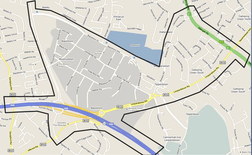
ROD – Aecom Alliance                                             Dún Laoghaire – Rathdown County Council
Consulting Engineers                                                  ESB Link Road & Link to Arena Road

Non-Technical Summary
1.0      Introduction

         This Environmental Report (ER) has been prepared by Roughan & O'Donovan -
         AECOM Alliance (ROD-AECOM) for Dún Laoghaire Rathdown County Council
         (DLRCC) as part of the documentation to accompany a Part 8 planning process for
         the proposed ESB Link Road and Link to Arena Road between M50 Junction 14 and
         Blackthorn Road. The scheme includes the replacement of the roundabout at ESB
         Junction 14 with a signalised junction and the construction of a new signalised
         junction on Blackthorn Road. The ER documents the assessment of the impact of
         the proposed development on the environment in the vicinity of that development.

         This non-technical summary summarises the outcome of the environmental
         assessment and highlights, in non-technical language, the main impacts of the
         proposed scheme.

2.0      Background to the Scheme

         The Sandyford Urban Framework Plan has planned for the increase in the working
         and living population within the area from an estimated 15,000 in 2006 to 40,000 in
         2016 and to 55,500 by 2030. The traffic study carried out during the development of
         the SUFP determined that this growth requires, in the short term, to be supported by
         a number of additional elements of road and public transport infrastructure, including
         the proposed ESB Link Road and Link to Arena Road.

         The Sandyford Urban Framework Plan was incorporated into the Dún Laoghaire -
         Rathdown County Development Plan in September 2011 as Variation No. 2.

3.0      Description of Proposed Scheme

         The development site is located in the Sandyford and Leopardstown Road area of
         South Dublin. The proposed development comprises: -
         •       The provision of a new road link between the existing signalised roundabout at
                 M50 Junction 14 and Blackthorn Road.
         •       A link from the new road above to the existing cul-de-sac at Arena Road
         •       The replacement of the signalised roundabout at Junction 14 with a signalised
                 junction.
         •       Construction of a new signalised junction on Blackthorn Road.
         •       Improvements to pathways, cycleways and crossings and improvements to the
                 quality of the public realm locally.
         •       Upgraded public lighting

4.0      Alternatives Considered

         At the time of the development of the Sandyford Urban Framework Plan, a number of
         alternatives were considered:
         (i)     A slip road from the M50 southbound off-slip onto Heather Road;
         (ii)    Construction of the Burton Hall Road Extension instead.
         (iii)   Do Nothing

12.171.10 Part 8 Planning Environmental Report    October 2013                                   Page 1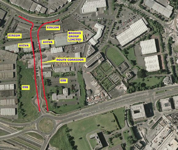
ROD – Aecom Alliance                                            Dún Laoghaire – Rathdown County Council
Consulting Engineers                                                 ESB Link Road & Link to Arena Road

         Both of the above were examined individually and in conjunction with the ESB Link
         Road and Link to Arena Road. In the case of the former, the National Roads
         Authority had significant concerns and expressed a strong preference that the
         scheme be combined with the ESB Link Road so as to have one exit point only
         towards Sandyford Business District from the M50 southbound off-slip. In the case of
         the latter two options, the development aspirations for Sandyford Business District
         could not be accommodated without the development of both the Burton Hall Link
         Road and the ESB Link Road and Link to Arena Road. Therefore, both schemes
         were included as Objectives of the Development Plan.

5.0      Traffic

         The Transportation Study that informed on the preparation of the Sandyford Urban
         Framework Plan determined a road configuration that represents the level of new
         road infrastructure required to facilitate the future office development envisaged.
         This roads configuration was included in the Sandyford Urban Framework Plan as
         TAM18: Six-Year Roads Objectives and incorporates the following schemes: -
         •       Burton Hall Road Extension
         •       Leopardstown Roundabout Reconfiguration
         •       Leopardstown Link Road (with access to car parks in Central Park)
         •       Direct access from M50 Junction 14 diverge ramp (the preferred option for
                 which is to the ESB Link Road and Link to Arena Road
         •       Bracken Road Extension
         •       Blackthorn & Arena Road Links (or ESB Link Road and Link to Arena Road)
         •       Sandyford Orbital Quality Bus Corridors

         Consideration was also given to the NRA’s recent M50 Demand Management Study.
         However, no adjustment of future traffic demand forecasts has been made in this
         study and as such the traffic analysis represents a robust assessment of the road
         network within the Sandyford Business Estate and that of the National Road network.

         Traffic analysis shows that the road will operate at near full capacity at the time of
         opening. Daily traffic flows of 10,000 vehicles are predicted for the route. The road
         will mitigate congestion on the local road network, especially at the Leopardstown
         Roundabout/ proposed signalised junction.

         The preferred scheme will not have any significant impact on the traffic demand or
         operation of the M50. Specifically the provision of a fully signalised junction to
         replace the current signalised roundabout will ensure that any queuing back along
         the M50 southbound off-slip will be controlled by the timings of the signals to ensure
         that queues do not extend back towards the M50 mainline.

6.0      Impact on Human Beings

         The area adjacent to the proposed road is a mix of brown field, commercial, open
         space and institutional land uses. Most existing development consists of commercial
         office and warehouse type development. Future population growth in the area is an
         objective of the County Council Development Plan, and this will depend on the
         provision of new commercial residential development as envisaged by the Sandyford
         Urban Framework Plan. Improvements to the local transportation infrastructure as

12.171.10 Part 8 Planning Environmental Report   October 2013                                   Page 2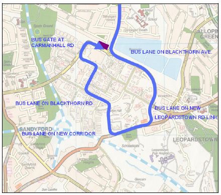
ROD – Aecom Alliance                                            Dún Laoghaire – Rathdown County Council
Consulting Engineers                                                 ESB Link Road & Link to Arena Road

         set out in the SUFP are a prerequisite to support the anticipated population growth in
         the area.

         The proposed road will facilitate further residential and commercial development in
         the Sandyford area by mitigating congestion that would otherwise arise on the
         existing road network.

         The proposed road scheme, in conjunction with other transportation initiatives will
         ensure that the area of Sandyford Business District will remain an attractive location
         for businesses. This will support demand for commercial and professional services,
         thereby increasing local employment opportunities.

7.0      Environmental Issues

7.1      Noise and Vibration
         During the construction phase of the project there will be some small impact on
         nearby properties due to noise emissions from site traffic and other activities. The
         transient nature of construction works, the application of binding noise limits and
         hours of operation, along with implementation of appropriate noise control measures,
         will ensure that noise impact is kept to a minimum.

         The predicted noise level generated by the proposed road development during the
         operational phase is not expected to represent a significant increase on current noise
         levels in the area.

         Ground vibrations produced by road traffic are unlikely to cause perceptible structural
         vibration in properties located near to well-maintained and smooth road surfaces.

7.2      Air Quality and Climate
         The air quality in the vicinity of the proposed ESB link Road will not be significantly
         affected by vehicle exhaust emissions.

7.3      Hydrology and Hydrogeology
         The proposed scheme will have no impact on and water quality. Mitigation measures
         to ensure water quality is maintained during construction are provided.

7.4      Soil
         The proposed ESB link Road will have no impact on the soil along the scheme.

8.0      Ecology (Flora & Fauna)

         A flora and fauna survey was carried out along the proposed ESB Link road and Link
         to Arena Road project in November 2012. The flora and fauna survey was carried
         out to investigate the potential impacts of a proposed development flora and fauna.

         The site for the proposed project consists mainly of buildings and artificial surfaces,
         non-native shrub and immature tree lines and built ground. There is one culverted
         stream under the proposed link road. No flora, fauna or habitats of conservation
         importance were discovered during the present survey. Mitigation measures are
         recommended, mainly with respect to timing of clearance works and water quality, to
         help prevent unnecessary negative impacts to local wildlife populations and aquatic
         environment.

12.171.10 Part 8 Planning Environmental Report   October 2013                                   Page 3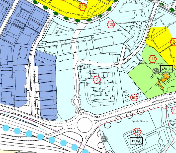
ROD – Aecom Alliance                                             Dún Laoghaire – Rathdown County Council
Consulting Engineers                                                  ESB Link Road & Link to Arena Road

         There are a number of nature conservation designated areas within 10km of the site.
         These include South Dublin Bay Special Area of Conservation (SAC) and South
         Dublin Bay and Tolka Estuary Special Protection Area (SPA) downstream of the
         proposed works. An Appropriate Assessment Screening for potential impacts on the
         Natura 2000 network of SAC’s and SPA’s has been carried out and is reported in
         Appendix 1 of this document. Following an appraisal of the potential impacts of the
         proposed ESB Link Road & Link to Arena Road on the Natura 2000 network, the
         likelihood of significant negative impacts arising on either the qualifying interests
         (South Dublin Bay SAC and South Dublin Bay and Tolka Estuary SPA) or on the
         integrity of any Natura 2000 site, has been ruled out. Therefore it is possible to
         screen out the need for an Appropriate Assessment and it is not deemed necessary
         to undertake any further stages of the Appropriate Assessment process.

9.0      Landscape and Visual Impacts

         The proposed scheme will not have an adverse impact in its setting. A reinforced
         concrete retaining wall is required along one section on the east boundary of the road
         otherwise the proposed road generally follows the existing ground levels. The route
         travels though an industrial / business district that has no landscape and visual
         sensitivities.

10.0     Material Assets

         The proposed ESB Link Road will run between two warehouses on lands owned by
         Aviva Insurance. This area is currently used as a yard to service the warehouse to
         the west, which is owned by Aviva. As such, there will be a significant negative
         impact on this land.

         It is understood that both other directly affected landowners; ESB and EIRCOM;
         intend to redevelop their sites in the medium term and the delivery of the proposed
         ESB Link Road will facilitate this. Therefore, while the proposed road scheme may
         have a moderate negative impact on the landholdings in the short term, its medium
         term impact will be significantly positive.

         The warehouses to the east of Aviva are in the control of Brooks Ltd. The impact on
         these will be neutral, as the proposed road will cause additional severance but will
         provide more direct access.

11.0     Architectural, Archaeological and Cultural Heritage

         All works will take place, with only minor surface effects, either within the corridor of
         the existing road or directly adjacent to the existing road in land that has been subject
         to recent development. All works will take place outside the boundary and curtilage
         of the protected structure of Burton Hall. Consequently there are no predicted
         impacts on architectural, archaeology and cultural heritage.

12.0     Construction Phase

         The construction of the road scheme will cause an increase in noise during working
         hours, but contract conditions will limit this noise to acceptable levels. Working hours
         will be limited, thereby avoiding the potential for disturbance of residents at night.
         The Contract will include requirements for appropriate measures to prevent an
         accidental spillage of pollutant materials into watercourses. The Contractor will be
         obliged to ensure that the surrounding roads are kept free from dirt. Construction

12.171.10 Part 8 Planning Environmental Report    October 2013                                   Page 4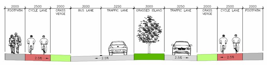
ROD – Aecom Alliance                                             Dún Laoghaire – Rathdown County Council
Consulting Engineers                                                  ESB Link Road & Link to Arena Road

         traffic for the scheme will be directed to use main roads to access the site and
         residential areas will not be affected.

13.0     Mitigation Measures

         The following is a summary of the mitigation measures that will be undertaken to
         reduce the potential environmental impacts of the proposed ESB Link Road & Link to
         Arena Road scheme:
         •       Noise control measures during construction will minimise disturbance to local
                 residents.
         •       Machinery and compounds will be positioned, where possible, to avoid undue
                 disruption.
         •       Pollution control measures will be taken to protect the surface water drainage
                 system during construction.
         •       The contractor will be required to prevent dirt from being released onto public
                 roads.

14.0     Further Information

         Copies of the full Part 8 Environmental report may be inspected at the following
         locations: -

                 Dún Laoghaire - Rathdown County Council,
                 County Hall,
                 Marine Road,
                 Dún Laoghaire,
                 Co. Dublin.

                 Dún Laoghaire - Rathdown County Council,
                 Dundrum Office Park,
                 Main Street,
                 Dundrum,
                 Dublin 14.

15.0     Planning Process

         Section 179 of the Planning and Development Act 2000 as amended, and Part 8 of
         the Planning and Development Regulations, 2001 to 2011 set out the process to be
         used for planning approval of local authority projects that are not subject to a
         requirement for a formal Environmental Impact Statement under other relevant
         legislation. The planning approval process will involve a period of public consultation
         after which Dún Laoghaire - Rathdown County Council will review any submissions
         made by the public. The final decision to approve or reject the scheme will be made
         at a meeting of the elected members of the County Council.

12.171.10 Part 8 Planning Environmental Report    October 2013                                   Page 5
ROD – Aecom Alliance Dún Laoghaire – Rathdown County Council
Consulting Engineers ESB Link Road & Link to Arena Road
Chapter 1 Introduction
1.1 Introduction
This Environmental Report (ER) has been prepared by Roughan & O'Donovan -
AECOM Alliance (ROD-AECOM) for Dún Laoghaire Rathdown County Council
(DLRCC) as part of the documentation to accompany a Part 8 planning process for
the proposed ESB Link Road and Link to Arena Road between M50 Junction 14 and
Blackthorn Road.
The construction of the ESB Link Road and Link to Arena Road is a six-year
objective of DLRCC included in the Sandyford Urban Framework Plan, an approved
Variation to the current County Development Plan (2010 – 2016). As the impacts of
the scheme are local to the Dún Laoghaire - Rathdown County Council administrative
jurisdiction, the scheme does not feature in national or regional policy, but sits within
such broader policy in the context of the approved Dún Laoghaire - Rathdown
County Development Plan.
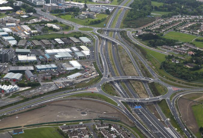
Figure 1.1 M50 Junction 13 / 14
The principal requirements of the proposed project are to deliver increased levels of
accessibility to Sandyford Business Estate for all modes to avoid a situation where
further development leads to an increase in congestion on existing approaches,
particularly along the M50 and N11 approaches. The scheme will facilitate and
support the expected growth in traffic arising from the future development envisaged
by the Sandyford Urban Framework Plan and will fulfil the improved public transport
objectives for the area (the ESB Link Road forms part of the Sandyford Orbital Bus
Route). The delivery of the scheme will proceed in parallel with various initiatives to
encourage the use of sustainable transport modes, as documented in the County
Development Plan and supporting documentation.
12.171.10 Part 8 Planning Environmental Report October 2013 Page 6ROD – Aecom Alliance Dún Laoghaire – Rathdown County Council
Consulting Engineers ESB Link Road & Link to Arena Road
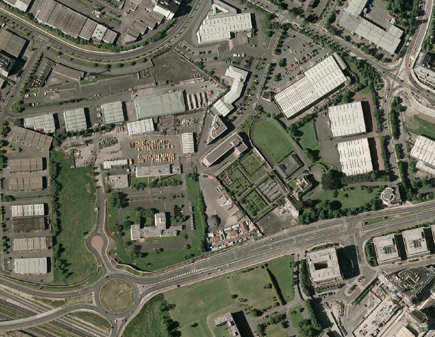
Figure 1.2 Aerial View
Figure 1.3 Extract from DLR County Development Plan 2010 – 2016
Proposed ESB Link Road
and Link to Arena Road
12.171.10 Part 8 Planning Environmental Report October 2013 Page 7ROD – Aecom Alliance Dún Laoghaire – Rathdown County Council
Consulting Engineers ESB Link Road & Link to Arena Road
1.2 Planning Process
The planning for the proposed project is undertaken in accordance with the
legislative requirement in Part XI, Section 179 of the Planning & Development Act,
2000 as amended. Part 8 of the Planning and Development Regulations, 2001 to
2011 details the class of development that is prescribed for the purposes of Section
179 of the Act and the relevant class for the proposed scheme is as follows:
b) “Construction of a new road or widening or realignment of an existing road, where
the length of the new road or of the widened or realigned portion of the existing road,
as the case may be, would be – in the case of a road in an urban area, 100 metres or
more,”
Under Part 8 of the Regulations, the Local Authority is required to make details of the
proposed road development available for public inspection and comment and to
prepare a report in relation to the proposal for consideration by the elected members
of the local authority. This Environmental Report (ER) contains information on the
potential environmental impacts of the proposed scheme. It has been prepared in
accordance with the information requirements of the Planning and Development Act
(2000) and Planning and Development Regulations (2001).
The purpose of the ER is to identify the potential impacts the proposed scheme will
have on the environment and to propose measures to avoid, reduce or remedy
undesirable potential impacts as appropriate.
1.3 Legislative Requirement for an Environmental Impact Report
Article 8 of the Roads Regulations 1994 prescribes the types of proposed road
development that require the preparation of an Environmental Impact Assessments
as: -
• Construction of a motorway.
• Construction of a new road of four or more lanes, or the realignment or
widening of an existing road so as to provide four or more lanes, where such
new, realigned or widened road would be 8km or more in length in a rural area
or 500m or more in length in an urban area.
• Construction of a new bridge or tunnel, which would be 100m or more in length.
The proposed ESB Link Road will involve the provision of approximately 350 metres
length of new single carriageway road linking Blackthorn Road and the roundabout at
M50 junction 14. The proposed scheme also includes the provision of a new
northbound quality bus corridor a new signalised junction at Blackthorn Road and the
replacement of the signalised roundabout at M50 junction 14 with a signalised
junction. A link from the proposed road to Arena Road will involve the provision of
approximately 145 metres length of new single carriageway road. Improvements will
also be made to the existing Blackthorn Road at the approaches to the new junction.
As such the ESB Link Road & Link to Arena Road development does not require the
preparation of an Environmental Impact Statement under the relevant legislation.
However it was decided by Dún Laoghaire Rathdown County Council to prepare an
Environmental Report (ER) for this scheme, broadly following the same process as
would be undertaken for a full Environmental Impact Statement.
Approval for the South Eastern Motorway scheme was granted by the Minister for the
Environment and Local Government on the 19th October 1998 under section 51 of
the Roads Act 1993 without any modifications. The South Eastern Motorway (SEM)
scheme approved consisted of the construction of approximately 10.9 kilometres of
12.171.10 Part 8 Planning Environmental Report October 2013 Page 8ROD – Aecom Alliance Dún Laoghaire – Rathdown County Council
Consulting Engineers ESB Link Road & Link to Arena Road
two by two lane motorway, six motorway interchanges, 21 structures, 2.7 kilometres
of dual carriageway and 4 kilometres of ancillary roads.
Having regard to the nature, complexity and scale of the overall SEM project it is
considered that the modifications now proposed, i.e. the modifications to the ESB
roundabout, are not of such significance as to change the essential nature of the
development or to result in the proposed road development being of a significantly
different development from that for which approval has been previously granted.
Therefore, whilst due regard was had to the Environment Impact Statement (EIS)
prepared for the South Eastern Motorway (September 1997) it is considered that the
Environmental Report prepared for the ESB Link Road & Link to Arena Road
adequately addresses any potential impacts on the environment of the proposed
scheme.
1.4 Format of the Environmental Impact Report
The ER is prepared having regard to the requirements of Section 50 of the Roads Act
1993 as amended.
Section 50 of the Roads Act and the Environmental Impact Assessment Regulations
require that the following information be included in an EIS:
“A description of the proposed road development comprising information on the
site, design and size of the proposed road development;
• A description of the measures envisaged in order to avoid, reduce and, if
possible remedy significant adverse effects;
• The data required to identify and assess the main effects which the
proposed road development is likely to have on the environment;
• An outline of the main alternatives studied by the road authority
concerned and an indication of the main reasons for its choice, taking into
account the environmental effects;
• A summary in non-technical language of the above information.
An Environmental Impact Statement also requires, in addition to and by way of
explanation or amplification of the specified information referred to above further
information on the following matters:
A description of the physical characteristics of the whole proposed road development
and the land-use requirements during the construction and operational phases,
An estimate, by type and quantity, of the expected residues and emissions (including
water, air and soil pollution, noise, vibration, light, heat and radiation) resulting from
the operation of the proposed road development.
A description of the aspects of the environment likely to be significantly affected by
the proposed road development, including in particular-
• Human beings, fauna and flora,
• Soil, water, air, climatic factors and the landscape,
• Material assets, including the architectural and archaeological heritage, and
the cultural heritage,
• The inter-relationship between the above factors;”
The Environmental Report has been prepared with regard to the above requirements.
The format used in this Environmental Report document seeks to allow the reader to
access the issues of interest to them as easily as possible.
12.171.10 Part 8 Planning Environmental Report October 2013 Page 9ROD – Aecom Alliance Dún Laoghaire – Rathdown County Council
Consulting Engineers ESB Link Road & Link to Arena Road
Chapter 2 Background to Scheme
2.1 Objectives of the Proposed Road
The Sandyford Urban Framework Plan has planned for the increase in the working
and living population within the area from an estimated 15,000 in 2006 to 40,000 in
2016 and to 55,500 by 2030. The traffic study carried out during the development of
the SUFP determined that this growth requires, in the short term, to be supported by
a number of additional elements of road and public transport infrastructure, including:
• M50 junction 14 diverge ramp access to Sandyford
• Revised access to South County Business Park (the Leopardstown Link Road)
including an access to the car parks within Central Park
• The Bracken Road Extension to the Drummartin Link Road
• Burton Hall Road Extension to Leopardstown Road
• ESB Link Road and Link to Arena Road
• Reconfiguration of the Leopardstown Roundabout
• Bus/Luas Interchange at the Stillorgan Luas stop
• Lower Kilmacud Road Quality Bus Corridor
• Internal circular Quality Bus Corridor
• Tallaght to Sandyford Quality Bus Corridor
• Cycling and Walking Routes
Several studies and traffic models were undertaken in selecting the schemes to
feature in the final plan. These included the Sandyford Land Use and Transportation
Study by FaberMaunsell and modelling for the SUFP itself by Mott McDonald. This
process is summarised in the Transportation Background Paper for the SUFP,
available on the DLRCC website.
At the time of the development of the Sandyford Urban Framework Plan, a number of
alternatives was considered:
(i) A slip road from the M50 southbound off-slip onto Heather Road;
(ii) Construction of the Burton Hall Road Extension instead.
(iii) Do Nothing
Both of the above were examined individually and in conjunction with the ESB Link
Road and Link to Arena Road. In the case of the former, the National Roads
Authority had significant concerns and expressed a strong preference that the
scheme be combined with the ESB Link Road so as to have one exit point only
towards Sandyford Business District from the M50 southbound off-slip. In the case of
the latter two options, the development aspirations for Sandyford Business District
could not be accommodated without the development of both the Burton Hall Road
Extension and the ESB Link Road and Link to Arena Road. Therefore, both
schemes were included as Objectives of the Development Plan.
12.171.10 Part 8 Planning Environmental Report October 2013 Page 10ROD – Aecom Alliance Dún Laoghaire – Rathdown County Council
Consulting Engineers ESB Link Road & Link to Arena Road
2.2 Recent Developments
The Council adopted the Sandyford Urban Framework Plan as Variation No.2 to the
County Development Plan 2010-2016 at the Council meeting held on 12th
September 2011. The variation includes the ESB Link Road and Link to Arena Road
as a six-year roads objective and details the road reservation on the “Land Use
Zoning” map.
Figure 2.1 Sandyford Urban Framework Plan – Land Use Zoning Map
2.3 Objectives of the ESB Link Road and Link to Arena Road
All of the access routes constructed into Sandyford Business District from the M50
were designed to prioritise the movement of vehicular traffic and remain, despite
some improvements, hostile to pedestrians and cyclists. This has resulted in many
commuters being put off these modes - even for short trips from the far side of the
M50 motorway. One of the key principles being adopted for the design of the ESB
Link Road and Link to Arena Road scheme is that the facilities provided for
pedestrians and cyclists are as good as or better than the facilities being provided for
private cars.
The development of the scheme design coincided with the launch of the Design
Manual for Urban Roads and Streets. Additionally, the design team liaised
extensively with the design teams working on developing lands along the route,
thereby ensuring that the completed scheme would integrate well into the future
urbanised context.
The ESB Link Road and Link to Arena Road forms part of the proposed orbital bus
route in Sandyford Business District, and therefore it is a requirement that the
scheme provide good quality facilities for buses in the northbound direction.
The scheme has been designed having regard to the geometric criteria of the Design
Manual for Urban Roads and Streets, permitting tighter radii to regulate traffic
speeds. The proposed vertical alignment has been designed with a maximum
gradient of 4% so as to ensure its attractiveness to pedestrians and cyclists.
12.171.10 Part 8 Planning Environmental Report October 2013 Page 11ROD – Aecom Alliance Dún Laoghaire – Rathdown County Council
Consulting Engineers ESB Link Road & Link to Arena Road
Chapter 3 Description of Proposed Scheme
3.1 Road Layout
Based on the principle of providing pedestrian and cycle facilities as good as or
better than the facilities for cars, the following general layout has been proposed for
the scheme:
• Footways: A 2m footpath to be provided on either side of the road.
• Cycleways: A 2.5m two-way cycle track to be provided on either side of the
road.
• Public Transport: A 3m bus lane to be provided in the northbound direction.
• Car traffic: One 3.25m through traffic lane in each direction and a 3m central
reservation for turning lanes to serve the development lanes on either side.
Additional turning lanes provided at major junctions.
• Landscaping: A 2.0m verge to be provided on either side of the road between
the kerb-line and the cycle tracks to accommodate landscaping. The verges
shall be kept clear of longitudinal services to facilitate tree planting.
The route of the proposed scheme runs north from the M50 Junction 14 northern
roundabout through the ESB Lands. The route then cuts between two warehouses
owned by AVIVA to the north through the yard between the two warehouses. The
route then curves eastward through lands owned by EIRCOM to join Blackthorn
Road East.
Figure 3.1 Proposed Route
The scheme has been the subject of a Road Safety Audit and a Road User Audit, the
recommendations of which have been incorporated by the Design Team, as
appropriate.
12.171.10 Part 8 Planning Environmental Report October 2013 Page 12ROD – Aecom Alliance Dún Laoghaire – Rathdown County Council
Consulting Engineers ESB Link Road & Link to Arena Road
Figure 3.2 Typical Cross Section
3.2 Cycling and Walking Facilities
The Dún Laoghaire - Rathdown County Development Plan Policy T12 is to promote
cycling and walking through the provision of cycle and pedestrian facilities in the
design of public transport routes and road schemes. The Sandyford Urban
Framework Plan adopted as Variation No.2 to the County Development Plan 2010 –
2016 includes objective TAM6 to implement this cycling and walking route as part of
the provision of this new road proposal. In accordance with the Development Plan
and the Sandyford Urban Framework Plan, pedestrian and cycle facilities will be
provided on both sides of the ESB Link Road and Link to Arena Road scheme.
3.3 Sandyford Bus Route
The Sandyford Land Use and Transportation study 2006 proposed a bus route as
shown below, with a view to providing a fast and effective route through Sandyford.
It provides good connectivity with the Luas and development throughout the
Sandyford Business District.
Figure 3.3 Sandyford Orbital Bus Route
The ESB Link Road and Link to Arena Road forms part of the proposed orbital bus
route in Sandyford Business District, and therefore it is a requirement that the
scheme provide good quality facilities for buses in the northbound direction.
12.171.10 Part 8 Planning Environmental Report October 2013 Page 13ROD – Aecom Alliance Dún Laoghaire – Rathdown County Council
Consulting Engineers ESB Link Road & Link to Arena Road
3.4 Public Lighting
A public lighting scheme has been devised, taking account of the different character
of various affected roads, including the proposed urban environment of the ESB Link
Road and Link to Arena Road and the motorway environment at M50 Junction 14.
Columns of 10m and 12m are proposed at various locations, with wattages varying
from 150W to 400W, as detailed on the accompanying drawings. Class CE1 lighting
is to be provided at junctions, with Class ME2 on all roads except Arena Road Link,
which will have Class ME3a.
3.5 Drainage
The drainage arrangements may ultimately be influenced by the attenuation
proposals for adjoining lands, however, a notional design has been proposed that
can function and be constructed independently of the development of the adjoining
lands. The areas beneath the verge and cycle track construction should be
constructed of permeable materials to permit infiltration into the surrounding soils. A
partially perforated pipe should be incorporated to allow the conduct of water when
the infiltration zone reaches saturation. At the lower reaches, larger fully enclosed
pipes should be used to allow online attenuation. The drainage will discharge to the
Sandyford Stream at its culvert in the Eircom lands. A hydrobrake should be
installed to limit the rate of discharge to the stream and the upstream attenuating
pipes sized accordingly. The drainage of the proposed M50 Junction 14 signalised
junction should discharge to the existing piped drainage network at the roundabout.
3.6 Structures
No significant structures are required to accommodate the proposed scheme.
Retaining walls (approximately 150m in length) may be required through the ESB
lands to limit the footprint of the scheme. The retaining walls will be reinforced
concrete with a patterned finish or as may be agreed with the relevant landowner.
The maximum height of any such wall is approximately 2.75m above ground level.
The scheme runs over a culvert carrying the Sandyford Stream in the Eircom lands.
The culvert is approximately 2m below the proposed road and already carries traffic
above. The structure will be assessed at the detailed design stage to ensure its
adequacy in the long term.
3.7 Earthworks
The proposed vertical alignment falls at a constant gradient through the ESB lands
before following existing ground levels from the northern boundary of the ESB site to
Blackthorn Road. Approximately 2,500m3 of imported fill will be required to achieve
the proposed vertical alignment through the ESB site.
3.8 Road Construction
It is anticipated that the road construction will consist of:
• 300mm of capping material (large crushed stone)
• 150mm of sub-base (small crushed stone)
• 150mm of road base
• 65mm of binder course
• 35mm of surface course.
12.171.10 Part 8 Planning Environmental Report October 2013 Page 14ROD – Aecom Alliance Dún Laoghaire – Rathdown County Council
Consulting Engineers ESB Link Road & Link to Arena Road
The proposed surface course is polymer modified stone mastic asphalt, which
generates less noise when trafficked than other materials and is therefore more
suited to an urban area.
The depth of capping material required will have to be confirmed at detailed design
stage, subject to confirmation of the strength of the underlying sub grade. It is
anticipated that 300mm should be adequate, as there is very strong granite at
shallow depth and the materials above are likely to consist of weathered granite.
3.9 Junctions
A detailed traffic analysis of the scheme was undertaken to inform the design of the
junctions at either end. The following synopsises the initial findings:
• The heaviest traffic movements at the northern end of the scheme are between
Blackthorn Road East and the ESB Link Road. On that basis, the priority on
Blackthorn Road has been changed such that the through traffic movement will
be between Blackthorn Road East and the new link road. Blackthorn Road
West will be accessed via a signalised junction. A right turning lane will be
provided for traffic from the north. The bus lane will stop 30m south of the
junction to accommodate left turners from the ESB Link Road. The traffic
analysis has indicated that the bus lane will be sufficiently close to the junction
to allow a bus to pass the stop line in a single signal cycle.
• The northern roundabout at M50 Junction 14 was recently signalised to
improve throughput of traffic and to prevent queuing onto the M50 mainline.
The recent improvements have significantly enhanced capacity. The traffic
analysis has indicated that the introduction of a significant new road access
onto the roundabout will be incompatible with the current signalised roundabout
layout. Furthermore, the existing layout is unconducive to the safe passage of
pedestrians and cyclists. Therefore, it is proposed to convert the existing
signalised roundabout to a four arm signalised junction.
3.10 Landscaping
A landscaping scheme has been developed for the proposed Link Road in
consultation with the Developers of the adjoining lands so as to ensure the proposed
scheme integrates into the future urbanised environment. The selection of trees and
shrubs has been made having regard to the sometimes windy conditions and the
need to design the planting accordingly. The design of the landscaping also takes
account of the desire to minimise the ongoing maintenance requirement. Further
details of the landscaping proposals are shown on the detailed drawings forming part
of this Part 8 planning application.
3.11 Other Utilities and Services
It is likely that the final scheme will include ancillary underground elements to serve
the Sandyford Business District, including, inter alia:
• Watermains
• Diverted ESB cables
• Foul sewerage.
Other utilities such as gas mains may also be required. These features will not
impact appreciably on the design of the road, as they will be constructed below
ground under the footpaths and cycle tracks. The verge shall be kept clear of
services in order to facilitate tree planting. However it may be necessary for services
to cross the verge at particular locations. The exact nature and number of services to
be accommodated will be established during the detailed design stage.
12.171.10 Part 8 Planning Environmental Report October 2013 Page 15ROD – Aecom Alliance Dún Laoghaire – Rathdown County Council
Consulting Engineers ESB Link Road & Link to Arena Road
Chapter 4 Alternatives Considered
4.1 Alternatives Considered
In developing the road strategy for the Sandyford Urban Framework Plan a number
of alternative road configurations were considered and examined using the SATURN
traffic model. The conclusion of the SUFP roads study determined the optimum
configuration required to facilitate the further development envisaged by the plan for
the area. This optimum configuration includes the ESB Link Road and Link to Arena
Road and the M50 junction 14 diverge ramp access to Sandyford (provided via a free
flow slip to the ESB Link Road).
At the time of the development of the Sandyford Urban Framework Plan, a number of
alternatives were considered:
• A slip road from the M50 southbound off-slip onto Heather Road;
• Construction of the Burton Hall Road Extension instead.
• Do Nothing
Both of the above were examined individually and in conjunction with the ESB Link
Road and Link to Arena Road. In the case of the former, the National Roads
Authority had significant concerns and expressed a strong preference that the
scheme be combined with the ESB Link Road so as to have one exit point only
towards Sandyford Business District from the M50 southbound off-slip. In the case of
the latter two options, the development aspirations for Sandyford Business District
could not be accommodated without the development of both the Burton Hall Road
Extension and the ESB Link Road and Link to Arena Road. Therefore, both
schemes were included as objectives of the Development Plan.
The proposed route has been developed in conjunction with landowners along the
scheme extent and is considered optimal taking into account both existing land uses
and proposed future developments.
The do nothing scenario presents an alternative to the proposed scheme, however
this alternative would not facilitate any further development within the Sandyford
Business District, without exacerbating traffic congestion.
The design of a do minimum scenario was considered involving the construction of
the ESB Link Road without the quality bus corridor. However, this was dismissed in
order to fulfil the improved public transport objectives for the area.
12.171.10 Part 8 Planning Environmental Report October 2013 Page 16ROD – Aecom Alliance Dún Laoghaire – Rathdown County Council
Consulting Engineers ESB Link Road & Link to Arena Road
Chapter 5 Traffic Impacts
5.1 Traffic Model
The primary analysis tool that has been used for the traffic assessment and project
appraisal is the Sandyford VISSIM Model, developed by AECOM and Roughan &
O’Donovan in 2011 on behalf of the NRA as a decision making tool in the
signalisation of the ESB Roundabout. The Sandyford models were developed as
microsimulation models using the transportation modelling software VISSIM (V5.4-
02). This type of model is particularly suited to small scale congested urban
networks, simulating the behaviour of individual vehicles within the network.
The VISSIM model has been developed specifically to account for route choice
effects of network interventions through the Sandyford area, and to allow replication
of the complex interaction through a number of complex junctions. The study area of
the Sandyford VISSIM model is outlined below in Figure 3.1.
Figure 5.1: Boundary of Sandyford VISSIM Model
The models were developed to replicate a Base year of 2012, covering the AM Peak
period (07:00 –10:00) and PM Peak period (16:00 – 19:00).
The model calibration process was undertaken in accordance with the requirements
of PAG Unit 5.2: Construction of Traffic Models and with reference to the calibration
criteria outlined in Table 5.2.2 of that Unit. The models were developed based on
traffic information for 31 junctions (including significant SCATS data) and utilising a
number of journey time surveys. The models have been calibrated to a standard
compliant with the PAG criteria for all user classes and all time periods.
The outputs of the Sandyford VISSIM models (for instance travel time, delay time
and vehicle kilometres) have been utilised to inform an appraisal of the scheme.
12.171.10 Part 8 Planning Environmental Report October 2013 Page 17ROD – Aecom Alliance Dún Laoghaire – Rathdown County Council
Consulting Engineers ESB Link Road & Link to Arena Road
Full details of the various models are included in the Traffic Modelling Report
(Appendix 3).
5.2 M50 Demand Management Study
The NRA in conjunction with a number of local authorities in the Greater Dublin Area,
including: Dún Laoghaire Rathdown; Fingal; and South Dublin County Councils
recently undertook an extensive study into traffic demand measurements along the
M50. These objective traffic management measures were to reduce demand on the
M50, such that it operates without congestion for longer; and improve the safety and
reliability of the M50 by reducing congestion. Measures were identified in order to
achieve these objectives. These measures are as follows:
• Fiscal Measures – multi point tolling along the M50;
• Intelligent Transport Systems/Traffic Control – variable speed limits and
incident management services;
• Information – information from the traffic control systems to be provided to the
public via the internet;
• Smarter Travel – area based travel planning, most notably in the Sandyford
Area; and
• Provision of a traffic control centre.
Modelling undertaken to supplement the M50 Demand Management Study indicated
that the measures outlined above would have a significant impact on travel behaviour
including: reassignment to avoid the tolls; some mode shift from the private car; and
demand changes. Consequently, the study forecasts a reduction in demand along
the M50 and also a reduction in traffic volumes using the on and off ramps at M50
Junction 14 to the order of 45% during the AM peak. Therefore, no adjustment of the
demand matrices was considered necessary. As such, the traffic modelling
undertaken represents a robust assessment of the road network within the Sandyford
Business Estate and that of the National Road network.
5.3 M50/M11 Corridor Study
The subject study has been undertaken with reference to the M50/M11 Corridor
study. The M50/M11 Corridor study was undertaken to understand transport
pressures between Sandyford and Fassaroe in Wicklow. The study included a range
of road upgrades and traffic management measures within the study area. The final
future scenario included some 40 separate schemes and included the subject
scheme, the ESB Link Road and Link to Arena Road. Additional schemes within the
study area, that were also included within the M50/M11 Corridor study include:
Burton Hall Extension; signalisation of Leopardstown Roundabout; Leopardstown
Link / Central Park to South County Business Park Link Road; Murphystown Link
Road. Each of these schemes have been considered to some extent within the
subject study.
5.4 The Sandyford Urban Framework Plan
The Sandyford Urban Framework Plan (SUFP) identified a number of road
improvement schemes in the Sandyford area, which are in the final stages of
planning/pre construction and are due to be constructed within the next two years.
For the purposes of this study it is assumed these will be in place in advance of the
ESB Link Road and Link to Arena Road being implemented. These improvements
constitute the “Do-Minimum” Scenario. The “Do-Something” Scenario is then taken
as the addition of the proposed ESB Link Road and Link to Arena Road scheme.
12.171.10 Part 8 Planning Environmental Report October 2013 Page 18ROD – Aecom Alliance Dún Laoghaire – Rathdown County Council
Consulting Engineers ESB Link Road & Link to Arena Road
Schemes included in the Do-Minimum Scenario
• Scheme 1: Burton Hall Road Extension
• Scheme 2: Replacement of Leopardstown Roundabout with signals
Schemes included in the Do-Something VISSIM models
• Scheme A: ESB Link Road to Blackthorn Road (incl different junction options)
• Scheme B: Additional link to Arena Road
Finally the forecast future traffic demand was calculated based on the proposed
future development included in the SUFP. As described in the Traffic Modelling
Report a design year of 2019 was taken for the completion of the SUFP.
AM and PM peak hour Do-Minimum and Do-Something models were created for both
2012 (current flows) and 2019 (SUFP flows). In addition a number of sub-models
were developed to assess the performance of various different junction options in the
design year of 2019. For the northern junction with Blackthorn Road different
arrangements of a three arm traffic signalled junction were assessed before arriving
at the preferred layout. For the southern junction, the existing ESB roundabout,
options were explored for upgrading the current signalised roundabout and for
replacing this with a conventional 4-arm traffic signal controlled junction. The Traffic
Modelling Report describes the relative performance of these options in 2019 and
explains why the preferred arrangement, a 4-arm signalised junction, was selected
as the preferred scheme.
The 2012 and 2019 Do-Minimum and Do-Something traffic models were compared to
identify the impact on traffic that the proposed scheme is forecast to have and to
determine the traffic flows along the new link road. This comparison showed that the
principal effect of the ESB Link Road will be to provide an alternative route into the
Business Estate and ease traffic congestion that would otherwise occur if the scheme
were not constructed. In particular there is forecast to be a significant reduction of
the eastbound flow along Leopardstown Road in the AM peak period. In addition the
left turning manoeuvre from Leopardstown Road into the Business Estate via the
Leopardstown Roundabout or Burton Hall Road Extension is forecast to be reduced
significantly.
Full details of these impacts are included in the Traffic Modelling Report. A summary
of the overall impact of the scheme on the Sandyford road network is provided in
Tables 3.1 and 3.2 below. These show that based on 2012 flows the scheme will
have a relatively small positive impact on average traffic speed, travel time and
distance travelled. Based on the forecast 2019 traffic flows associated with the
SUFP the scheme has very significant positive impact on average speeds and travel
times compared to the Do-Minimum scenario.
Table 5.1: 2012 Network Performance Statistics
AM Period PM Period
Indicator Units Vehicles
Do Min Do Some Do Min Do Some
Lights 44.0 45.4 43.1 44.4
Average Speed (km/hr)
Heavies 36.9 36.8 36.7 37.4
Ave. Travel Time /
(hrs) All Vehicles 0.080 0.076 0.080 0.077
vehicle
Average Distance
(km) All Vehicles 3.483 3.432 3.439 3.421
Travelled
12.171.10 Part 8 Planning Environmental Report October 2013 Page 19ROD – Aecom Alliance Dún Laoghaire – Rathdown County Council
Consulting Engineers ESB Link Road & Link to Arena Road
Table 5.2: 2019 Network Performance Statistics
AM Period PM Period
Indicator Units Vehicles
Do Min Do Some Do Min Do Some
Lights 10.4 32.0 6.3 22.6
Average Speed (km/hr)
Heavies 11.8 30.7 6.6 22.6
Ave. Travel Time /
(hrs) All Vehicles 0.108 0.584 0.152
vehicle 0.345
Average Distance
(km) All Vehicles 3.542 3.433 3.690 3.424
Travelled
Forecast junction traffic flows for 2019 along the ESB Link Road are shown in the
figure below.
Figure 5.2 2019 Forecast Junction Traffic Flows
12.171.10 Part 8 Planning Environmental Report October 2013 Page 20ROD – Aecom Alliance Dún Laoghaire – Rathdown County Council
Consulting Engineers ESB Link Road & Link to Arena Road
Chapter 6 Impact on Human Beings
6.1 Introduction
This chapter of the Environmental Report describes the impact of the proposed
project on the “human environment” in terms of population, employment and
community impacts.
Sandyford Business District is one of the largest and most important employment
districts in the country. The Business District includes numerous offices, services
and apartment blocks and is home to over 600 major national and multinational
companies. Future zoning for the immediate environs of the proposed ESB Link
Road and Link to Arena Road is made up largely of office and enterprise
development with open space and ancillary active recreational amenities and for the
creation of sustainable residential neighbourhoods.
The proposed project will result in a loss of lands currently used as warehousing and
storage for ESB, Eircom and tenants of Aviva (Ireland). The development will have a
positive impact on all residential and commercial development and those working in
the Sandyford District in terms of facilitating area-wide traffic management especially
during peak hours. The additional traffic capacity provided by the ESB Link Road
and Link to Arena Road, in conjunction with the other roads proposals identified in
the Sandyford Urban Framework Plan will allow for future planned development in
Sandyford Business District.
6.2 Population
Receiving Environment for Population
The area adjacent to the proposed road is a mix of brown field, commercial, open
space and institutional land uses. Most existing development consists of commercial
office and warehouse type development. Future population growth in the area is an
objective of the County Council Development Plan, and this will depend on the
provision of new commercial residential development as envisaged by the Sandyford
Urban Framework Plan. Improvements to the local transportation infrastructure as
set out in the SUFP are a prerequisite to support the anticipated population growth in
the area.
Predicted Impact of Scheme for Population
The proposed road will facilitate further residential and commercial development in
the Sandyford area by mitigating congestion that would otherwise arise on the
existing road network.
6.3 Employment
The predicted impacts on employment due to the various stages of the scheme are
outlined below:
Construction Phase
The construction phase of the roads scheme will generate construction employment
on site in addition to jobs in support industries e.g. builders suppliers, local retailers
etc.
12.171.10 Part 8 Planning Environmental Report October 2013 Page 21ROD – Aecom Alliance Dún Laoghaire – Rathdown County Council
Consulting Engineers ESB Link Road & Link to Arena Road
Operational Phase
The development of the scheme, in conjunction with other transportation initiatives
for the area will insure that the area of Sandyford Business District will remain an
attractive location for business at an important nodal point within a regional multi-
modal transportation network. This will result in the increased demand for
commercial and professional services, thereby increasing employment opportunities
within the Sandyford Business District area.
Do Nothing Impact:
If the road is not constructed, there will be an increase in traffic congestion on the
local road network and the potential for future commercial and residential
development in the area of Sandyford Business District will be curtailed.
6.4 Community Impact
Receiving Environment
The receiving environment is in brown-field industrial use and is zoned for
redevelopment (contingent on the provision of the proposed road scheme).
Predicted Impact of Proposed Community Impacts
The proposed scheme will increase permeability into and out of Sandyford Business
District, benefiting both the population of the Business District and the population of
hinterland areas south of the M50.
No additional severance will arise between communities because of the proposed
road. There will be a beneficial community impact arising from the provision of
additional communication routes for traffic, cyclists and pedestrians.
12.171.10 Part 8 Planning Environmental Report October 2013 Page 22You can also read