Estuarine Vegetation Survey : Whangamata Harbour and Otahu Estuary - Environment Waikato Technical Report 2007/25
←
→
Page content transcription
If your browser does not render page correctly, please read the page content below
Environment Waikato Technical Report 2007/25

Estuarine Vegetation Survey :
Whangamata Harbour and
Otahu Estuary

www.ew.govt.nz
ISSN 1172-4005 (Print)
ISSN 1172-9284 (Online)
Prepared by:
Meg Graeme (Natural Solutions - Marine and Terrestrial Ecologists Ltd.)
RD 2
COROMANDEL
Ph: (07) 866 0770
Email: natural.solutions@wave.co.nz

Natural Solutions Contract Report 07/067

For:
Environment Waikato
PO Box 4010
HAMILTON EAST

30 May 2007

ISSN: 1172-4005

Document #: 1193164
Peer reviewed by:
Dr. Catherine Beard           Date     June 2007

Approved for release by:
Dr. Peter Singleton           Date     June 2007

Disclaimer
This technical report has been prepared for the use of Waikato Regional Council as a reference
document and as such does not constitute Council’s policy.

Council requests that if excerpts or inferences are drawn from this document for further use by
individuals or organisations, due care should be taken to ensure that the appropriate context
has been preserved, and is accurately reflected and referenced in any subsequent spoken or
written communication.

While Waikato Regional Council has exercised all reasonable skill and care in controlling the
contents of this report, Council accepts no liability in contract, tort or otherwise, for any loss,
damage, injury or expense (whether direct, indirect or consequential) arising out of the provision
of this information or its use by you or any other party.

Doc # 1193164
Doc # 1193164
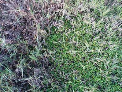
Table of Contents
1         Introduction                                             1
2         Methodology                                              1
    2.1     Wetland vegetation classification                      1
    2.1.1   Saltmarsh                                              1
    2.1.2   Mangrove                                               2
    2.1.3   Seagrass                                               2
    2.1.4   ‘Weed community’                                       2
3         Field notes                                              2
    3.1     Summary                                                2
    3.2     Site descriptions                                      4

4         Discussion                                              56
    4.1     Whangamata Harbour                                    56
    4.2     Otahu Estuary                                         56
    4.3     Recommended action points / restoration projects      57

5         References                                              59
6         Appendices                                              60

Doc # 1193164                                                  Page i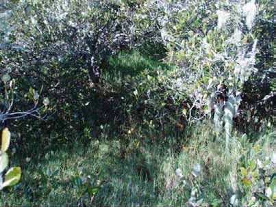
Page ii Doc # 1193164
1       Introduction
        A 1997 pilot study of Whangamata, Wharekawa, and Otahu estuaries determined that
        it is feasible to map vascular estuarine vegetation from aerial photography together
        with field surveys. The success of this work encouraged Environment Waikato to
        continue with this method. The estuarine vegetation of Tairua, Coromandel, Te
        Kouma, Manaia and Whitianga estuaries were mapped in 1998 and 1999.             Port
        Waikato, Raglan, Aotea, Kawhia estuaries and the inner Firth of Thames have recently
        been mapped between 2004 and 2006.

        The vegetation that has been mapped is in the Coastal Marine Area (CMA) and
        includes the spatial cover of mangrove, seagrass, sea meadow, and saltmarsh
        communities. The results of the estuarine surveys are included in Environment
        Waikato’s Global Information System (GIS) database, and are used for State of the
        Environment investigations and assessing consent applications that may affect
        estuarine vegetation.

        This report details the results from a survey of estuarine vegetation in the Whangamata
        Harbour and Otahu Estuary. These are the first estuaries to be re-surveyed using this
        methodology. Comments are included on the threats to estuarine vegetation, and other
        field notes of interest. This report is accompanied by digitised aerial maps of the
        survey site with vegetation community overlays.

2       Methodology
        The field survey was undertaken over 6 days between the 2nd and 16th April 2007. The
        survey was undertaken using a combination of boating and walking. The same
        methodology for mapping saltmarsh, mangrove, seagrass and weed communities was
        followed as that previously used to map earlier surveyed estuaries (see Graeme, 1997,
        1998a, 1998b, 1999) except that a personal digital assistant (PDA) loaded with 2006
        aerial maps of the survey sites was used as the primary mapping device. The PDA
        replaced notations on hard copy aerial maps, although hard copy aerials were used as
        a backup for when the PDA battery ran out or lighting made it too difficult to see the
        PDA screen clearly in the field. Colour-coded lines were drawn directly onto the PDA
        aerials to define the spatial extent of wetland vegetation types as they were ground-
        truthed in the field.

        The upper saltwater influence is usually indicated by the upstream limit of oioi, and this
        is generally the case for Whangamata and Otahu. Exceptions are sites at which oioi is
        not present or is uncommon. In such cases the upper estuarine limit is indicated by the
        extent of mangroves, spartina, saltwater paspalum or bachelor’s button.

        Field notes were made of estuarine wetland characteristics and their vulnerability to
        threats.

2.1     Wetland vegetation classification
        For the purposes of this investigation, wetland vegetation species influenced by the
        tidal cycles are split into four groups: saltmarsh, mangrove, seagrass and weed
        communities.

2.1.1   Saltmarsh
        A broad-species community in which three sub-communities are distinguishable. They
        are:
        a) ‘Rush/sedge community’ – this is generally sea rush (Juncus kraussii subsp.
            australiensis), oioi (Apodasmia similis). and on the West Coast, three-square sedge
            (Schoenoplectus pungens).         Marsh clubrush (Bolboschoenus fluviatilis) is

        Doc # 1193164                                                                       Page 1
commonly found up streams and rivers at the upper estuarine limit in some
harbours but is not mapped within this study as it is a brackish-freshwater species.
b) ‘Saltmarsh ribbonwood community (SMR)’ - this includes areas where rushes
are interspersed with saltmarsh ribbonwood (Plagianthus divaricatus), giving a
patchy appearance compared with the uniformity of the ‘rush/sedge community’.
Small areas of sea primrose (Samolus repens), remuremu (Selliera radicans), the
coast spear grass (Austrostipa stipoides), and glasswort (Sarcocornia quinqueflora)
can also be present.
c) ‘Sea meadow community’ - this is devoid of tall plants such as rushes and
saltmarsh ribbonwood, with the exception of coast spear grass. The sea meadow
community includes sea primrose, remuremu, glasswort, and in more brackish
areas bachelor’s button (Cotula coronopifolia), leptinella (Leptinella doica), sharp
spike-sedge (Eleocharis acuta), slender clubrush (Isolepis cernua), and arrow grass
(Triglochin striata).
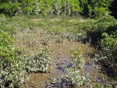
2.1.2 Mangrove
(Avicennia marina subsp. australasica) – this is usually a monospecific community
although seagrass, spartina, saltwater paspalum and sea meadow beds can
sometimes be found below mature mangrove stands
2.1.3 Seagrass
(Zostera capricorni) – this is usually a monospecific community
2.1.4 ‘Weed community’
In the Waikato Region the most significant estuarine weeds are saltwater paspalum
(Paspalum vaginatum) and cord grass (Spartina spp.). Both of these weeds generally
grow in the open estuary and trap sediment, greatly increasing the harbour’s infilling
rate. These weeds also compete with the native wetland communities, particularly
saltwater paspalum which vigorously competes with all vegetation types.
There are other weed species which can tolerate salty environments but for clarity of
mapping have not been included in the surveys due to their presence above the spring
high tide mark.
3 Field notes
3.1 Summary
The following observations give a general overview of estuarine vegetation in the
Whangamata Harbour and Otahu Estuary.
WHANGAMATA HARBOUR
• Extensive seagrass beds occur throughout the middle reaches of the harbour.
• Extensive mangals dominate the upper harbour embayments.
• Large oioi and sea rush beds are limited mainly to the Moanaanuanu arm and the
embayment enclosed by the Papamaire Island causeway.
• Sizeable sea meadow communities are also mainly limited to the Moananauanu
arm and the embayment enclosed by the Papamaire Island causeway.
• An unidentified grass is present in the sea rush/oioi band at the end of Allan Place.
This will need to be identified when flowering in summer to establish whether it is
an exotic species of concern.
• No spartina was found.
Page 2 Doc # 1193164
•   Saltwater paspalum is scattered around the harbour. The largest infestation was
    found at the mouth of the Kaupeka Stream. The overall extent of saltwater
    paspalum seems to have increased dramatically since the 1995 survey.
•   Sea meadow and rushland communities are the most threatened by the expansion
    of saltwater paspalum.
•   There is often sign of cleared mangroves in front of residential land – notably the
    southern side of the Allan Drive peninsula, the tip of Durrant Drive, north-west and
    south of Tukere Drive and south of the Moanaanuanu arm causeway.
•   The Moanaanuanu arm and the embayment enclosed by the Papamaire Island
    causeway had the highest diversity of estuarine vegetation communities. This is
    due to the riverine influence and lack of infilling or drainage that is often common at
    the upstream salt wedge zone.
•   The predominant land uses around the harbour margin are pine forestry (with and
    without native riparian buffers) and residential housing.
•   The upper and western side of the harbour has very narrow (or non-existent)
    forestry riparian set-backs compared to the riparian margins around the eastern
    side of the harbour.
•   Grazed farmland abutting the harbour margin is only present on the two small
    peninsulas on the upper north-western side of the harbour. Stock damage to the
    harbour edge is limited to a few small areas.
•   The debris build up and die-back of mangroves around a number of stream mouths
    was evidence of flash flooding.

OTAHU ESTUARY
• Seagrass is limited to the margins of the lower estuary and commonly associated
  with overhanging pohutukawa. Seagrass is also present at the head of the estuary
  where the river channel is still confined.
• Mangroves are restricted to the mid-estuary with recent expansion being limited to
  along the true right bank (TRB).
• Sea meadow communities are rare.
• Saltmarsh ribbonwood and rushland communities are common.
• Saltwater paspalum is prevalent and dominant throughout the estuary and
  expanding its extent.
• Saltwater paspalum appears to have almost completely out-competed the natural
  sea meadow communities. Small remnant sea meadow areas are intermixed with
  saltwater paspalum.
• Saltwater paspalum is restricting and reducing the extent of saltmarsh ribbonwood
  and rushland communities.
• The estuarine-freshwater-coastal forest vegetation sequence along the majority of
  the true right bank, and a 13ha strip extending 750m inland (occurring mainly in the
  ‘Maori Whangamata’ land title) on the TLB, is highly significant due to the
  vegetation communities’ intactness, sequence continuity, diversity and habitat
  value for threatened wetland birds.
• The diverse mosaic of estuarine and freshwater wetland communities in the upper
  estuary supports a high fernbird population. Australasian bittern are also present,
  and banded rail and spotless crake (freshwater) are likely to be.
• Stock grazing within the CMA and further upstream along the river banks is
  occurring in places. However some landowners have undertaken good riparian
  protection with stock-proof fencing.
• There are many opportunities for riparian vegetation restoration along the upstream
  pastoral farm edges and the lower TLB margins.

Table 1 lists common plant species found during the surveys (See Appendix 6 for a full
list of species mentioned in this report). The ‘estuarine vegetation community’ category
for the estuarine species corresponds to the colour-coded vegetation boundaries of the
aerial map.

Doc # 1193164                                                                       Page 3
Table 1:   Check list of common estuarine and freshwater plant species of
      Whangamata Harbour and Otahu Estuary.

      Common/Maori name            Scientific name                            Estuarine
                                                                              Vegetation
                                                                              Community
      arrow grass                  Triglochin striata                         sea meadow
      blue-green sedge             Baumea juncea
      coastal shrub daisy          Olearia solandri                           saltmarsh ribbonwood
      glasswort                    Sarcocornia quinqueflora                   sea meadow
      mangrove                     Avicennia marina subsp. australasica       mangrove
      manuka                       Leptospermum scoparium
      mingimingi/swamp coprosma    Coprosma propinqua
      oioi                         Apodasmia similis (=Leptocarpus similis)   rush/sedge
      pampas                       Cortaderia selloana, C. jubata
      raupo                        Typha orientalis
      remuremu                     Selliera radicans                          sea meadow
      saltmarsh ribbonwood         Plagianthus divaricatus                    saltmarsh ribbonwood
      saltwater paspalum           Paspalum vaginatum                         weed
      sea primrose                 Samolus repens                             sea meadow
      sea rush                     Juncus krausii subsp. australiensis        rush/sedge
      seagrass                     Zostera capricorni                         seagrass
      coast spear grass            Austrostipa stipoides (=Stipa stipoides)   sea meadow
      slender clubrush             Isolepis cernua                            sea meadow
      tall fescue                  Schedonorus phoenix

3.2   Site descriptions
      WHANGAMATA HARBOUR

      Whangamata Harbour is described anticlockwise from the harbour mouth opposite the
      wharf. See Figures 1a and 1b for a map showing the site localities (in bold) and figure
      numbers mentioned below.

      Small sand dunes within the outer embayments are characterised by open coast dune
      vegetation (Figure 2) until saltwater paspalum and small patches of oioi and
      ribbonwood are found near the Waiariki Stream mouth (Figure 5). The land rises
      steeply from the harbour to coastal forest dominated by a pohutukawa canopy and a
      coastal five finger understorey (Figure 3). The health of this forest is improving with the
      control of wilding pines and possums. This native forest riparian edge helps provide
      coastal edge stabilisation and good protection against the adverse effects of the pine
      forestry above (i.e. erosion filtration, loss of natural character). This native forest
      riparian edge narrows further up the harbour until it is non-existent at the head of the
      harbour (Figures 4, 15 -17).

      Small patches of oioi occur further north along the coast, with individual mangroves
      (Figure 6). Further up the harbour, mangroves begin to form a band along more
      sheltered edges, and the saltwater paspalum patches become thicker. Coast spear
      grass occurs in small clumps on exposed rocky edges.

      A large seagrass bed extends along the north-eastern side of the main harbour
      channel past the upstream extent of moored boats (Figure 7).

      A dense patch of saltwater paspalum (knee high) has invaded the oioi band behind the
      mangroves at the mouth of the Te Wharawhara Stream (Figures 8, 9).

      Some of the tallest mangroves (~5.5m) in the harbour were found near the point west
      of Te Wharawhara Stream (Figure 10). Other tall mangroves were found at the mouth
      of the Waikoura Stream which were mostly 2-4m tall (Figure 11). Seagrass occurs
      beneath the mangroves in the Waikoura Stream channel and infrequently in small
      patches between the mangal and rushland zone. Figure 12 shows the upper estuarine

      Page 4                                                                       Doc # 1193164
extent of mangroves and oioi as the Waikoura Stream narrows. The rush/sedge zone varies from usually non-existent or narrow bands, to 20-30m wide bands. The infrequent wider areas of rushland occur at the head of embayments with wide mangals seaward. Commonly, the rush zone along more exposed edges is limited to the foot of the land margin (Figure 13). The upper harbour is characterised by a land margin of pines that over-shadow and often fall into the harbour (Figures 14 - 17). Where riparian margins are not planted in pine they are usually too narrow or disrupted for native coastal forest to be able to dominate, and wattle (Racosperma decurrens) often dominates instead. The mud flats under the wide mangals support titiko (a mud snail: Amphibola crenata), and in places also the small Potamopyrgus snail species (Figure 18). Mud at the head of these bays is usually 3-4cm deep (Figure 19). However in isolated areas associated with streams the mud can be as deep as 10cm (Figure 21). An area affected by recent silt deposits from upstream flooding occurs at a small stream mouth west of Waikoura Stream, where thick mud surrounds dead mangroves (Figure 20). The Papamaire Island embayment cut off by the State Highway is characterised by a mosaic of rushland (oioi and sea rush), saltmarsh ribbonwood patches and both healthy and dead/sick mangroves interspersed with arrow grass (Figures 22-25). There are also small patches of glasswort and sea primrose and one patch of remuremu. The mud is deeply cracked and has a green algal mat where wet. The large cracks in the mud and thick algal mats seem to indicate a recent change in the hydrology of the site, probably due to a flood event and impoundment of water. The mangroves have a lot of flood debris in their branches. A wide band of oioi and sea rush backed by a narrower band of saltmarsh ribbonwood dominates the embayment near the old Whangamata pub (Figure 26). Fernbird were heard in the ribbonwood here. Surrounding this embayment is a dense mangal that extends north of the ‘horticultural’ peninsula towards Papamaire Island. The peninsula (Allan Drive & Allan Place) was a horticultural farm and is now mainly developed as lifestyle blocks. A number of small patches of an unidentified grass occur at the end of Allan Place (Figures 27-28). The clearance of mangroves has occurred in areas near housing. This is particularly obvious on the southern side of the horticultural peninsula. Figure 29 is a view along the esplanade reserve towards the tip of the peninsula showing an abrupt mangrove line where mangroves have been cleared in the mid-foreground. Figure 30 is looking south west along the esplanade reserve and shows the degraded natural character of the coastal margin in front of the adjacent housing. Further mangrove clearance has occurred in the embayment to the west (Figures 31-32). Similar natural character issues of the coastal margin occur here too as vegetation removal has severely modified the bank. The largest infestation of saltwater paspalum found in the harbour is at the mouth of the Kaupeka Stream. The saltwater paspalum has established over an area of ~0.3ha that extends upstream to a raupo swamp, invading the oioi band and extending out under the mangrove canopy (Figures 33-35). Fernbird were heard around the embayment edge. There are a few small areas around Te Weiti Stream and around the point towards Waikiekie Stream where farm stock have access to the harbour and rubbish has been dumped in the CMA (Figure 36). Immediately north of the Waikiekie Stream mouth is an area of rushland within paddocks that is being grazed and could potentially be degraded through drainage or infilling (Figure 37). The estuarine channel of the Waikiekie Stream has been modified in an effort to minimise flooding impacts on the road upstream (Figure 38). Flood debris was evident Doc # 1193164 Page 5
amongst the rushland and mangroves (many of which were dead) (Figures 39-40). A
dense patch of saltmarsh ribbonwood has survived along the edge of the Everitt
Crescent esplanade reserve (Figure 40), however further to the east the ribbonwood
band is threatened by garden weeds and waste such as grass clippings, as well as
being physically infilled by recent drainage spoil dumping (Figure 41). Fernbird are
present in the ribbonwood but are known by local residents to be predated by
neighbourhood cats.

At the tip of the Durrant Drive headland an area of mangroves has been cleared
(Figure 42). Further around the tip beside the Waikiekie Stream channel another
smaller area of mangroves has been cleared.

Mangroves have been removed from the southern half of Patiki Bay (with and without
consent). Figure 43 shows an eroding coast line at the head of the bay with saltmarsh
ribbonwood. This exposed edge used to be protected by mangroves. A thin band of
seagrass extends around the southern side of the bay abutting the land edge.

The next narrow indented bay to the south has also had mangroves removed. A small
patch of seagrass and a band of oioi and sea rush are present. Remuremu is common
on the low-lying mown part of the walkway (Figure 44). A large seagrass patch
extends from the point southward to the Wentworth River channel as it leaves the
Moanaanuanu estuary. This seagrass also extends into the bay at the end of Awarua
Place. Here a patch of saltwater paspalum has established on the sandy beach.

Old large pohutukawa trees lean from the harbour edge over the mudflats from Moana
Point around to the causeway and up most of the Moanaanuanu estuary arm. These
trees are remnants of the original coastal forest that would have characterised the
steep coastal edges of the harbour.

The lower northern side of the Moanaanuanu estuary is characterised by mangroves
abutting the pohutukawa edge. Just upstream of the causeway small islands of
mangroves have been cut down. The mangroves thicken into the Okauanga Stream
arm and grade into a small area of rushland before reaching a drain and becoming
farmland (near the wastewater treatment plant).

Further upstream on the northern side the river channel swings in close to the steep
coastal edge before swinging away to the other side. As the channel moves away from
the land edge, the estuarine vegetation forms a diverse mosaic of sea meadow (mainly
glasswort), mangroves, rushland, saltmarsh ribbonwood and coastal forest islands
(Figures 45, 50). Fernbird were heard and banded rail footprints seen here. Saltwater
paspalum is beginning to invade the glasswort mats on this bank (Figures 48, 49).
Tree privet, pampas and wattle are particularly common on higher ground.

The estuarine vegetation zone thins as it reaches the Tairua Road bridge. Upstream
of the bridge the uppermost estuarine community is a wide patch of ribbonwood that
ends at the next bend (Figure 46).

The estuarine vegetation along the upper true right bank (TRB) of the Moanaanuanu
estuary is restricted immediately upstream and some way downstream of the Tairua
Road bridge due to the neighbouring land activity and stopbank (Figures 46-47). The
mixed rushland and saltmarsh ribbonwood communities expand down towards where
the housing property boundaries extend out into the CMA. The ribbonwood zone
includes flax and coastal shrub daisy, and at the junction with the houses, mangroves
begin to mix in. Seagrass occurs in behind a small mangrove island against the
reserve edge (Figure 48). Saltwater paspalum is invading the glasswort and sea
primrose around this island (Figure 49). As the river channel curves away to the TLB a
wide rushland band forms against the landward edge, fronted by a wide mangrove
band out to the channel. A large sea meadow community (mixed glasswort, sea
primrose and coast spear grass) occurs on the inner bend as the channel straightens

Page 6                                                                   Doc # 1193164
downstream towards the SH25 causeway (Figure 50). Saltwater paspalum is also
invading this community.

The rushland band diminishes towards the SH25 causeway while the mangrove band
expands. Adjacent to the causeway a large area of mangroves (~ 3ha) has been
cleared (Figure 51). Birds were noted feeding in the cleared area and fish were also
observed feeding at high tide. A strong unnatural sulphur smell was present when the
sediment was disturbed and a lot of rubbish was caught up amongst debris. A white
mould was common on woody debris and sediments. More mangroves had been
removed since the 2006 aerial photo used for this survey. Adjacent to the Firth cement
works and next to a manuka remnant (Figure 53) there is a large amount of fill along
the coastal edge (Figure 52).

A wide mangrove band flanks the downstream edge of the causeway and abuts a large
seagrass patch. Inland of the seagrass and mangroves is an embayment of rushland
(Figure 54). Both the rushland embayment and the open mangrove and seagrass beds
will be lost to a marina development.

The only estuarine vegetation found further around along the open sandy coastline
towards the harbour mouth is two patches of saltwater paspalum.

Doc # 1193164                                                                   Page 7
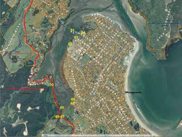
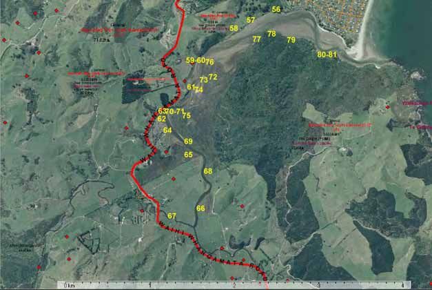
Figure 1a: Whangamata site localities mentioned in this report – upper harbour. The numbers refer to the location of the following figures.
Waikoura Stream
Papamaire Island
Te Wharawhara Stream
horticultural
peninsula
Kaupeka Stream
Te Weiti Stream
Patiki Bay
Waiariki Stream
Waikiekie Stream
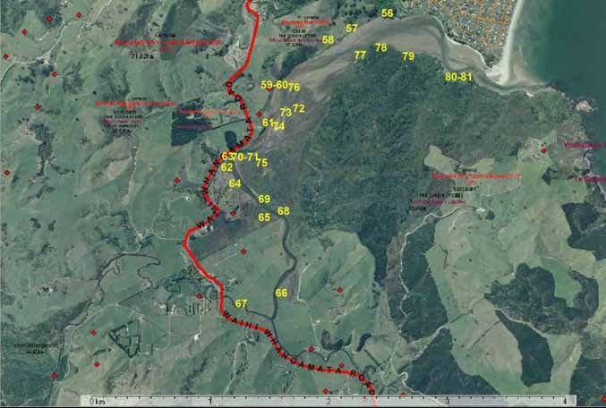
Page 8 Doc # 1193164Figure 1b: Whangamata site localities mentioned in this report – lower harbour. The numbers refer to the location of the following figures.
Moana Point
Moanaanuanu
estuary
Okauanga
Stream
Tairua Road
bridge
Doc # 1193164 Page 9Figure 2: Knobby clubrush (Ficinia nodosa), spinifex, flax and buffalo grass often characterise dunes, such as this example found near the harbour mouth. Whangamata 2/4/07 Figure 3: The south-eastern side of Whangamata Harbour is characterised by a wide band of regenerating coastal forest along the steep harbour edge. Dead pines that have been controlled on the headland in the middle of the picture are just visible. Whangamata 2/4/07 Page 10 Doc # 1193164
Figure 4: A view from the middle of the harbour over seagrass. The coastal riparian
edge narrows towards the head of the harbour. Whangamata 2/4/07

Figure 5: The closest estuarine vegetation to the open sea (harbour mouth) includes
this saltwater paspalum, ribbonwood, oioi and tall fescue at Waiariki Stream.
Whangamata 2/4/07

Doc # 1193164                                                               Page 11
Figure 6: Mangroves with oioi and coastal daisy behind. Whangamata 2/4/07

Figure 7: Seagrass and individual mangroves along the eastern harbour edge.
Whangamata 2/4/07

Page 12                                                               Doc # 1193164
Figure 8: Saltwater paspalum invading an oioi band at the mouth of the Te
Wharawhara Stream. Whangamata 2/4/07

Figure 9: The edge of the saltwater paspalum patch in Figure 8 above, showing it
expanding and intermingling with surrounding oioi. Whangamata 2/4/07

Doc # 1193164                                                            Page 13
Figure 10: A 5.5m high mangrove at Te Wharawhara Stream. Whangamata 2/4/07

Figure 11: Mangroves at the Waikoura Stream mouth. Whangamata 3/4/07

Page 14                                                            Doc # 1193164
Figure 12: Oioi along the upper Waikoura Stream mouth. Seagrass is present in the
stream bed. Whangamata 3/4/07

Figure 13: Sea rush, oioi and saltmarsh ribbonwood along a steeply rising harbour
edge margin with mangroves seaward. Head of the harbour, Whangamata 3/4/07

Doc # 1193164                                                             Page 15
Figure 14: A fallen pine at mouth of Waikoura Stream. Whangamata 3/4/07

Figure 15: Pine and wattle slash along the harbour edge. Whangamata 3/4/07

Page 16                                                               Doc # 1193164
Figure 16: Pines severely restricting riparian vegetation along the harbour edge.
Whangamata 3/4/07

Figure 17: Wattle and pine dominating the harbour edge. Whangamata 3/4/07

Doc # 1193164                                                               Page 17
Figure 18: Coastal swamp forest has been eliminated by pines planted up to the
saltmarsh ribbonwood zone. Whangamata 3/4/07

Figure 19: A close up of the mudflats in Figure 18 show titiko (mud snail) beneath the
short mangroves. Footprints in the back-swamp mud usually sink 3-4cm deep in the
soft rich orange silt. Whangamata 3/4/07

Page 18                                                                  Doc # 1193164
Figure 20: Dead mangroves amongst deep silt adjacent to a small river mouth (west of
Waikoura Stream). Whangamata 3/4/07

Figure 21: Deep silt (~10cm) around dead mangroves adjacent to a small river mouth
(west of Waikoura Stream). Whangamata 3/4/07

Doc # 1193164                                                                Page 19
Figure 22: A young patch of oioi is backed by sea rush, with the State Highway and
Papamaire Island in the background. Whangamata 3/4/07

Figure 23: A finger of healthy and dying mangroves line a channel which intersects
rushland in the Papamaire Island embayment, as viewed from the State Highway.
Whangamata 3/4/07

Page 20                                                               Doc # 1193164
Figure 24: Flood debris amongst dead or sick mangroves, arrow grass and sea rush.
Embayment west of Papamaire Island. Whangamata 3/4/07

Figure 25: Dead or dying mangroves in the embayment west of Papamaire Island.
Whangamata 3/4/07

Doc # 1193164                                                             Page 21
Figure 26: A wide oioi/sea rush band backed by a narrower band of saltmarsh
ribbonwood dominates the embayment near the old Whangamata pub. Small
scattered patches of sea primrose are also present between the rush and mangroves.
Whangamata 4/4/07

Figure 27: An unidentified grass found at the end of Allan Place. Whangamata 15/4/07

Page 22                                                                 Doc # 1193164
Figure 28: A close up of the unidentified grass found at the end of Allan Place.
Whangamata 15/4/07

Figure 29: An abrupt edge to a mangal where mangroves (some ~ 30 years old) have
been chopped down. Note the saltwater paspalum along the foreshore. A thin patch of
seagrass is present adjacent to the paspalum. ‘horticultural’ peninsula, Whangamata
15/4/07

Doc # 1193164                                                               Page 23
Figure 30: A highly modified coastal edge with native coastal edge vegetation removed
and estuarine vegetation disrupted. Note the cut mangroves dumped along the
foreshore over the sea meadow/rush/saltmarsh ribbonwood zone. Whangamata
15/4/07

Figure 31: Cut mangrove debris dumped along the coastal edge over rushes.
‘horticultural’ peninsula, Whangamata 15/4/07

Page 24                                                                 Doc # 1193164
Figure 32: Extensive mangrove clearance associated with housing. Mangrove seedlings are re-establishing. The natural character of the
harbour margin has also been severely degraded with vegetation clearance along the land edge also. East of Kaupeka Stream,Whangamata 16/4/07

Doc # 1193164                                                                                                                         Page 25
Figure 33: This is the largest infestation of saltwater paspalum found in the harbour.
The Kaupeka Stream channel is in the foreground. The saltwater paspalum mat is
knee deep. Whangamata 16/4/07

Figure 34: Saltwater paspalum underneath mangroves at the edge of the largest
infestation found in the harbour. Kaupeka Stream mouth. Whangamata 16/4/07

Page 26                                                                  Doc # 1193164
Figure 35: Looking up towards the mouth of the Kaupeka Stream. Saltwater paspalum
is invading the oioi to the left and mangroves to the right. Whangamata 16/4/07

Figure 36: Farm rubbish dumped in the CMA.     Waikiekie Stream mouth is in the
background. Whangamata 16/4/07

Doc # 1193164                                                             Page 27
Figure 37: Sea rush and some oioi (golden) within a paddock. The Waikiekie Stream
mouth and housing along Everitt Crescent is in the background. Whangamata 16/4/07

Figure 38: The modified Waikiekie Stream mouth. Whangamata 16/4/07

Page 28                                                              Doc # 1193164
Figure 39: Flood debris and dead mangroves. Near the Waikiekie Stream mouth,
Whangamata 16/4/07

Figure 40: A view from Everitt Crescent esplanade reserve overlooking a saltmarsh
ribbonwood, rushland, mangrove and sea meadow mosaic. Whangamata 16/4/07

Doc # 1193164                                                             Page 29
Figure 41: A recent infill associated with the dredging of the Waikiekie Stream mouth.
Whangamata 16/4/07

Figure 42: Cleared mangroves at the tip of Durrant Drive. Note the saltwater paspalum
overtaking the saltmarsh ribbonwood and oioi in the foreground. Whangamata 16/4/07

Page 30                                                                  Doc # 1193164
Figure 43: Saltmarsh ribbonwood lining an exposed and eroding land edge.
Mangroves were removed from in front of this coastal edge between July and
September 2000. Patiki Bay, Whangamata 16/4/07

Figure 44: This photo shows an area of mown sea meadow (remuremu) along part of
the Moana Point town walkway. Undisturbed estuarine vegetation is visible along the
unmown edge. Whangamata 16/4/07

Doc # 1193164                                                               Page 31
Figure 45: Coastal forest between the Tairua Road and Wentworth River channel
includes flax, akeake, coastal daisy and cabbage tree.    Moanaanuanu arm,
Whangamata 15/4/07

Figure 46: Wetland along the TRB upstream of the Tairua Road bridge is constricted by
a stopbank. The saltmarsh ribbonwood swamp in the background (TLB) is at the upper
limit of the saltwater influence. Moanaanuanu arm, Whangamata 15/4/07

Page 32                                                                 Doc # 1193164
Figure 47: A view looking downstream from the Tairua Road bridge showing the mix of
pampas, flax and saltmarsh ribbonwood and the unnatural landward edge of the
estuarine vegetation on the TRB. Moanaanuanu arm, Whangamata 15/4/07

Figure 48: A view from the Mayfair Avenue reserve looking upstream over a small
island with seagrass in the foreground and a mosaic of saltmarsh ribbonwood,
rushland, mangroves and coastal forest in the background. Moanaanuanu arm,
Whangamata 15/4/07

Doc # 1193164                                                               Page 33
Figure 49: Saltwater paspalum is invading glasswort at the downstream end of the
island in Figure 48 and along the TLB of the river. Moanaanuanu arm, Whangamata
15/4/07

Figure 50: A view looking from Tairua Rd over toward the reserve at Mayfair Av.
Large sea meadow communities on both sides of the river bend below are obscured
from view by the roadside vegetation. Moanaanuanu arm, Whangamata 16/4/07

Page 34                                                             Doc # 1193164
Figure 51: A view from the causeway looking over an area of cleared mangroves.
Birds were feeding amongst the remaining pneumatophores. The mud was very
smelly, and rubbish and a white mould were common. Whangamata 16/4/07

Figure 52: Infilling in the CMA causes loss of estuarine edge vegetation. The Firth
concrete town is in the background. Moanaanuanu arm, Whangamata 16/4/07

Doc # 1193164                                                               Page 35
Figure 53: A remnant manuka stand along the harbour edge downstream from Figure
50 above. Moanaanuanu arm, Whangamata 16/4/07

Page 36                                                            Doc # 1193164
Figure 54:      A view looking over the oioi and sea rush embayment soon to be filled in for marina car parking.   Whangamata 16/4/07

Doc # 1193164                                                                                                                 Page 37
OTAHU ESTUARY

Otahu Estuary is also described moving anticlockwise around the coastal edge from
the downstream true left bank (TLB) to the true right bank (TRB). See Figure 55 for a
map showing site localities mentioned below.

The first estuarine vegetation encountered is patches of saltwater paspalum
downstream and immediately out from Kotuku Street. A small patch of seagrass is
also present out from the boat ramp. Saltwater paspalum, rushland, saltmarsh
ribbonwood and a few patches of seagrass extend in a thin band upstream from the
housing towards the steep bush-lined coastal edge (before the stream south of the
refuse tip) (Figures 56, 57). Fernbird are present in the saltmarsh ribbonwood. Grazing
has limited the inland extent of estuarine vegetation in places (Figure 58).

Mangroves and extensive areas of saltwater paspalum dominate the stream mouth
south of the refuse tip (Figure 59). Major earthworks are being undertaken for a new
subdivision alongside this stream (Figure 60). Mangroves extend in a wide band
further upstream alongside the main channel, with scattered thin bands of saltmarsh
ribbonwood behind and thick saltwater paspalum mats at the channel edge (Figure 61).

The estuarine vegetation then thins as the channel moves in closer to the land edge
before widening again around the Parakiwai headland. Mangroves disappear at this
point. Figure 62 shows some old dead mangroves amongst saltwater paspalum that
were alive when mapped in 1996. A band of seagrass extends along the channel edge
either side of the headland. Where the tidal flats have been disturbed in the past for
farming, or still are grazed, saltwater paspalum is dominating amongst the rushland
and the natural inland extent of estuarine vegetation is restricted (Figure 63 - 64).
However south east and west of the headland, the estuarine and freshwater wetland
sequence is intact with scattered coastal swamp forest on the more raised ground
(Figure 65). Saltwater paspalum is mainly restricted to the channel edge. A bittern
was disturbed along the channel edge and fernbird were common here.

Further upstream the estuarine vegetation ends suddenly at a boundary drain and the
low-lying land is farmed from here up. Saltwater paspalum is common in hollows within
the paddock near the river and dominates the river edge to just past the confluence of
the Otahu River and Waiharakeke Stream. Figure 66 shows a section of riverbank
planted in flaxes that are surrounded by saltwater paspalum. There is a notable lack of
sea meadow species in this zone. Upstream of the confluence saltwater paspalum
grades into its freshwater equivalent Mercer grass (Paspalum distichum). A significant
length of the riverside has been fenced off from stock, however some banks are still
unstable due to unrestricted grazing. These areas tend to be on bends without steep
banks (Figure 67).

On the TRB, the furthest upstream rushland community occurs about 450m
downstream of the confluence, and extends some way inland either side of a drain.
Further downstream, patches of rushland and saltmarsh ribbonwood are scattered in
low points along the bank and compete with saltwater paspalum (Figure 68 - 69).
Seagrass occurs along the channel bank in long bands extending down past Parakiwai
headland.

Behind the estuarine edge, extensive freshwater swampland extends inland to the
regenerating coastal forest. Common freshwater swamp species include red mapou,
manuka, knobby clubrush, blue-green sedge, cabbage tree, flax, large-leaved
mingimingi, toetoe, swamp daisy, koromiko and native broom. Weed species included
pampas, casuarina and wilding pine.

The estuarine vegetation expands out to a mosaic of ribbonwood fingers dissected by
rushland and saltwater paspalum on the inside bend downstream and opposite
Parakiwai headland. Saltwater paspalum is particularly dominant here on the inside

Page 38                                                                   Doc # 1193164
bend and ‘cable’ island. Here, remnant sea meadow communities of remuremu,
glasswort and coast spear grass are intermingled with saltwater paspalum where the
paspalum has not yet formed dense closed canopy (Figures 70 - 71). Figures 72 and
73 show other examples of saltwater paspalum out-competing estuarine species. In
places the saltwater paspalum is over knee high. The upper limit of the main
mangrove band is just upstream of ‘cable’ island (Figure 74). Fingers of rushland lined
by saltmarsh ribbonwood extend into the freshwater wetland/coastal forest (Figure 75).
Fernbird were common throughout this estuarine and freshwater wetland mosaic.

Downstream of ‘cable’ island, saltwater paspalum is restricted to patches near the
channel edge and has yet to significantly invade the dense mangrove, rushland,
ribbonwood, swamp forest mosaic (Figure 76). Titiko (mud snail) are common
amongst the mangroves. Young mangroves have established and extend the
mangrove community downstream on open flats along the channel edge (Figure 77).

The mangroves peter out toward the main headland opposite the edge of the housing
and only a thin band of rushland, saltwater paspalum and isolated saltmarsh
ribbonwood continue along the foreshore towards the estuary mouth (Figures 78-81).
A band of seagrass also extends along the foreshore edge abutting large pohutukawa.
A small patch of three-square (Schoenoplectus pungens) is found amongst the
seagrass towards the estuary mouth (Figure 80). Three-square is uncommon in
Coromandel Peninsula harbours

Doc # 1193164                                                                   Page 39
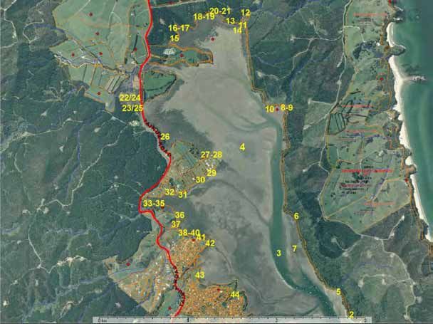
Figure 55: Otahu site localities mentioned in this report. The numbers refer to the location of the following figures

                                             Refuse tip

                                                                     ‘Cable’
                                                                     Island

                                     Parakiwai

                                       Otahu River

                                                                Waiharakeke Stream

Page 40                                                                                                                 Doc # 1193164
Refuse tip
Parakiwai
Otahu River
Waiharakeke Stream
Doc # 1193164 Page 41Figure 56: The foreshore at the edge of the housing is dominated by saltwater paspalum with sea rush, oioi, mangroves and saltmarsh ribbonwood also present. Various weed species are present along the land edge. Otahu 4/4/07 Figure 57: Further upstream on the TLB the inland extend of rushland and saltmarsh ribbonwood is restricted by farming development, while the seaward extent is restricted by saltwater paspalum. Otahu 4/4/07 Page 42 Doc # 1193164
Figure 58: Saltwater paspalum and sea rush extend into a paddock. Saltmarsh
ribbonwood however is restricted to seaward of the fence. Otahu 4/4/07

Figure 59: Saltwater paspalum dominates this small side creek on the TLB. Oioi, sea
rush and saltmarsh ribbonwood are restricted to a narrow band behind. Otahu 4/4/07

Doc # 1193164                                                               Page 43
Figure 60: Large scale earthworks for urban development being undertaken beside the
small creek shown in Figure 58. Otahu 4/4/07

Figure 61: Saltwater paspalum lining the river edge with mangroves, sea rush and
saltmarsh ribbonwood in behind. Otahu 4/4/07

Page 44                                                                Doc # 1193164
Figure 62: Dead mangroves amongst thick saltwater paspalum. Sea rush is in the
background. Otahu 4/4/07

Figure 63: Grazed and ungrazed rushland. Saltwater paspalum is dominating on the
inland disturbed (grazed) side of the fence. Otahu 4/4/07

Doc # 1193164                                                            Page 45
Figure 64: A grazed stretch of estuary bank with oioi (and submerged seagrass) in the
foreground, saltwater paspalum in the middle ground, and sea rush and manuka
swamp in the background. Otahu 4/4/07

Figure 65: Sea rush saltmarsh ribbonwood grading back to freshwater swamp forest.
Otahu 4/4/07

Page 46                                                                 Doc # 1193164
Figure 66: A recent river bank planting of flax amongst saltwater paspalum. Otahu
4/4/07

Figure 67: Unrestricted grazing along the Otahu River just upstream of the confluence.
Otahu 4/4/07

Doc # 1193164                                                                  Page 47
Figure 68: Near the top of the saltwater influence the river banks steepen. Patches of
rushland and saltmarsh ribbonwood are scattered in low points along the bank
competing with saltwater paspalum. Otahu 4/4/07

Figure 69: Saltwater paspalum dominating the river bank with saltmarsh ribbonwood
and freshwater swamp forest in behind. Otahu 4/4/07

Page 48                                                                  Doc # 1193164
Figure 70: Coast spear grass, saltmarsh ribbonwood, sea rush and mangrove surviving
amongst saltwater paspalum. Weed species on the higher ground include wilding pine
and casuarina. Otahu 5/4/07

Figure 71: Remuremu (light green) and glasswort (purple orange) compete with
saltwater paspalum near the coast spear grass shown in Figure 70 above. Otahu
5/4/07

Doc # 1193164                                                               Page 49
Figure 72: Dead saltmarsh ribbonwood and sea rush amongst saltwater paspalum.
Otahu 5/4/07

Figure 73: A mangrove subsumed in saltwater paspalum.     Glasswort has been
similarly subsumed on the hump behind. Otahu 5/4/07

Page 50                                                          Doc # 1193164
Figure 74: A view looking upstream along ‘cable’ island showing the expanse of
saltwater paspalum, scattered mangroves and patches of sea rush and saltmarsh
ribbonwood. Otahu 5/4/07

Figure 75: A sea rush arm edged with saltmarsh ribbonwood extending into freshwater
swamp forest. Otahu 5/4/07

Doc # 1193164                                                               Page 51
Figure 76: At the downstream extent of the rushland fingers there are isolated patches
of saltwater paspalum (light green). Here the saltwater paspalum is surrounded by a
patch of sea meadow (darker brown on mud) with coast spear grass on the higher
ground above the sea rush. Otahu 5/4/07

Figure 77: Looking upstream from the point opposite the edge of the housing. Young
mangroves are visible in a finger extending downstream along the river edge. Otahu
5/4/07

Page 52                                                                  Doc # 1193164
Figure 78: Saltwater paspalum, oioi and sea rush line the coastal edge on the point
opposite the end of the housing. Ngaio are present with the large pohutukawa. Otahu
5/4/07

Figure 79: A narrow band of oioi and sea rush lining the coastal edge with wild ginger
established between the rushes and regenerating coastal forest. Otahu 5/4/07

Doc # 1193164                                                                  Page 53
Figure 80: Saltwater paspalum extending out to seagrass and three-square, and inland
up through oioi, sea rush and saltmarsh ribbonwood. Otahu 4/4/07

Figure 81: A close up of the saltwater paspalum invading saltmarsh ribbonwood
pictured above. Otahu 4/4/07

Page 54                                                                Doc # 1193164
BIRDS

Birds seen or heard during the survey:
White faced heron, variable oyster catcher, South Island pied oyster catcher, pied stilt,
black backed gull, red billed gull, spur-winged plover, kingfisher, fernbird, bittern,
pukeko, pied shag, paradise duck, mallard duck.

WEEDS

Tree privet, pampas and wattle were the most common coastal edge weeds –
particularly on the TLB downstream of the Tairua Road bridge, and where pine
plantation set-backs were too narrow to allow undisturbed native forest to establish.

Wilding pines are a problem around the Otahu estuary. Another tree noted at Otahu
that is becoming a concern is the casuarina. Casuarina (C. glauca swamp oak/swamp
she-oak and C. equisetifolia Australian pine/beach she-oak) are from eastern Australia.
C. glauca inhabits saline swamps and spreads by root suckers forming dense thickets.
C. equisetifolia can tolerate the full blast of salt-laden winds and could become a
problem on dunes (Paddison & Bryant 2001).

Doc # 1193164                                                                     Page 55
4     Discussion
4.1   Whangamata Harbour
      The Whangamata Harbour has two predominant estuarine vegetation communities –
      seagrass and mangroves. These two communities provide specific and overlapping
      value to estuarine wildlife and the functioning of the harbour. Both communities
      stabilise sediments, enhance water quality, and add to the nutrient inputs of the
      harbour. Each community provides food and refuge for a variety of fish and
      invertebrates. Seagrass beds are valuable feeding grounds for many wading birds,
      while mangroves are valuable feeding, refuge, roosting/nesting grounds for banded rail,
      pukeko, heron and shag.

      The Moanaanuanu arm contains by far the most diverse collection of vegetation
      communities, and therefore has significant value in terms of estuarine vegetation. This
      floral diversity is in part due to a mosaic of different bed level heights allowing the
      establishment of ribbonwood and coastal swamp forest communities (which have
      generally not been interfered with by land development).

      Excluding the Te Moanaanuanu arm, large areas of rushland within the rest of the
      harbour are restricted to the heads of embayments. It may be that less sheltered
      margins have been too exposed (before mangroves established) for sea rush and oioi
      to establish. A possible future scenario might see the rushland expanding behind the
      protection of the mangroves and consolidating the silt that has built up in the harbour.

      A large variety of weeds characterise the western margin of the harbour, whereas the
      coastal margin of the eastern side is predominantly regenerating coastal forest. Pine
      forestry and its associated weeds characterise the harbour margin at the head of the
      harbour.

      If resources were available to control saltwater paspalum in Whangamata, the
      Moanaanuanu arm would be a priority site due to its floral diversity. Also the Kaupeka
      Stream mouth provides an opportunity to research the colonisation of native estuarine
      vegetation following control of saltwater paspalum. Here either rushes/sedges or
      mangroves would colonise the open ground exposed after the removal of saltwater
      paspalum there. However, the saltwater paspalum may have built up the sediment to
      an extent that, together with the slow water movement of the ‘back swamp’, rush/sedge
      establishment is favoured over mangroves.

      Two small recent infills associated with the dredging of the Waikiekie Stream mouth are
      unnecessary and contrary to outcomes promoted by the Regional Plan. These infills
      should be promptly removed and the area rehabilitated, as they send the wrong signals
      to the community regarding the value of the saltmarsh ribbonwood, rushland and
      mangrove communities they have covered. More considerate planning is required of
      the Regional Council for future waterway management works.

4.2   Otahu Estuary
      Saltwater paspalum has significantly increased in the area it dominates since the last
      survey and is severely threatening the long-term survival of the sea meadow
      communities. The saltmarsh ribbonwood community is also under pressure from the
      saltwater paspalum invasion. Figure 63 (grazed and non-grazed rushland) indicates
      that vegetation disturbance may play an important role in the spread and dominance of
      saltwater paspalum. Control of saltwater paspalum is highly recommended if the
      vegetation diversity and habitat values of the estuary are to be protected.

      Page 56                                                                    Doc # 1193164
Tall fescue was notably absent, particularly on the TRB. This may be due to the
intactness of the coastal vegetation sequence here.
The zone of mangroves is quite compact. Wave, wind and current exposure may
explain the downstream limit however the absence of mangroves along the bank
margins further upstream is unexpected. A possible reason may be the loss of habitat
to dense banks of saltwater paspalum. The only obvious area of mangrove expansion
is a finger of new plants along the edge of the river channel extending downstream
from the end of the rushland-ribbonwood-saltwater paspalum mosaic (Figure 77).
4.3 Recommended action points / restoration
projects
1. Collect a specimen of the unidentified grass in the saltmarsh near Allan Place in
summer when it is flowering to help identify the species
2. Control the pampas and wattle in the coastal swamp within the Moananauanu arm
and Otahu Estuary.
3. Undertake a feasibility study to control saltwater paspalum at Otahu and
Whangamata. Work undertaken in the Matua estuary (Tauranga Harbour)
indicates that eradication is only possible with long-term sustained control over at
least a 5 year period and then ongoing monitoring and eradication of re-
establishment areas. A trial could be undertaken whereby saltwater paspalum is
sprayed to 3m out from existing saltmarsh ribbonwood, rush and sea meadow to
encourage their expansion. If successful the spray zone could then be expanded.
However it is probably more economical initially to helicopter spray all infestations
as is done for spartina control.
4. Undertake saltwater paspalum control in the Moanaanuanu arm.
5. The Moanaanuanu arm and Otahu Estuary have particularly high biodiversity
values. Apart from the threat from invading saltwater paspalum, it is unclear if the
wetland bird populations may be threatened by animal pests. It may be beneficial
to undertake animal pest control around the wetland edges to help sustain the
wetland bird populations.
6. Aim to exclude all farming activities from the CMA and river margins.
7. A particular focus should be given to the protection of the remaining estuarine to
freshwater wetland sequences around the Otahu Estuary as this is a highly
significant wetland site. It is a remnant of a once extensive habitat that would have
dominated the low-lying coastal floodplains. These productive floodplains have
now generally been converted to farmland. Strong and meaningful (including
financial) support should be offered to the landowners of the remaining remnant
wetland habitat around the Otahu Estuary and its tributaries to enhance their
protection.
8. Remove the Waikiekie Stream mouth fill (‘dredgings’) along the Durrant Drive
esplanade reserve immediately and rehabilitate the site with locally sourced
saltmarsh ribbonwood.
9. Initiate a project to clearly identify all esplanade reserves and extend the walkway
system already well set up around Waireka Place and Moana Anu Anu Ave etc
where suitable. Identify areas of high wildlife value and ensure walkways (and
associated cats and dogs) are directed away from such areas
Doc # 1193164 Page 5710. Public education is needed regarding the dumping of garden waste and planting of
exotic garden species in public reserves. Work towards eliminating weed species
from the coastal margin.
11. Identify public reserves and active recreation areas (e.g. boat/canoe launching
sites) where it would be suitable to enhance access to open water. This could
include small-scale consented mangrove removal or boardwalks through mangals.
An example of where very small scale mangrove clearance may be appropriate is
at the tip of the Durrant Drive headland (southern side) to provide access to the
Waikiekie Stream channel. (Note: not the unconsented illegal clearance that has
been undertaken recently. Any clearance should be via a harbour plan).
12. Illegal mangrove destruction usually occurs where mangroves ‘block’ views of open
water or restrict access to open water. Effective enforcement action against illegal
mangrove removal is required as well as careful planning of housing near
mangrove habitat.
Page 58 Doc # 11931645 References
Graeme, M. 1997: Estuary Vegetation Survey Pilot Study: Whangamata, Otahu,
Wharekawa. Report prepared for Environment Waikato.
Graeme, M. 1998a: Estuary Vegetation Survey: Coromandel & Tairua Harbours.
Report prepared for Environment Waikato.
Graeme, M. 1998b: Estuary Vegetation Survey: Te Kouma & Manaia Harbours.
Report prepared for Environment Waikato.
Graeme, M. 1999: Estuary Vegetation Survey: Whitianga Harbour. Report prepared
for Environment Waikato.
Graeme, M. 2004: Estuarine Vegetation Survey: Port Waikato. Environment Waikato
Technical Report 2005/41. Waikato Regional Council (Environment Waikato), Hamilton
Graeme, M. 2004: Estuarine Vegetation Survey: Raglan. Environment Waikato
Technical Report 2005/44. Waikato Regional Council (Environment Waikato), Hamilton
Graeme, M. 2004: Estuarine Vegetation Survey: Aotea. Environment Waikato
Technical Report 2005/43. Waikato Regional Council (Environment Waikato), Hamilton
Graeme, M. 2006: Estuarine Vegetation Survey: Inner Firth of Thames. Environment
Waikato Technical Report 2006/40. Waikato Regional Council (Environment Waikato),
Hamilton
Graeme, M. and Kendal, H. 2001: Saltwater Paspalum (Paspalum vaginatum) – a
weed review. Report prepared for Environment Waikato.
Paddison, V. and Bryant, G. (Eds). 2001: Botanica’s Trees & Shrubs. Random House,
New Zealand.
Doc # 1193164 Page 596 Appendices
Plant species mentioned in this report. (* denotes an exotic species)
Common/Maori name Scientific name
arrow grass Triglochin striata
blue-green sedge Baumea juncea
broom Carmichaelia aligera
buffalo grass * Stenotaphrum secundatum
cabbage tree Cordyline australis
casuarina/swamp oak/swamp she-oak Casuarina glauca
*
coast spear grass Stipa stipoides
coastal five finger Pseudopanax lessonii
coastal shrub daisy Olearia solandri
flax Phormium tenax
Ginger * Hedychium gardnerianum
glasswort Sarcocornia quinqueflora
knobby clubrush Ficinia nodosa
koromiko Hebe stricta
large-leave mingimingi Leucopogon fascicularis
leptinella Leptinella doica
mangrove Avicennia marina subsp. australasica
manuka Leptospermum scoparium
mapou Myrsine australis
Mercer grass * Paspalum distichum
mingimingi/swamp coprosma Coprosma propinqua
ngaio Myoporum laetum
oioi Apodasmia similis
Pampas * Cortaderia selloana, C. jubata
pohutukawa Metrosideros excelsa
raupo Typha orientalis
remuremu Selliera radicans
saltmarsh ribbonwood Plagianthus divaricatus
saltwater paspalum * Paspalum vaginatum
sea primrose Samolus repens
sea rush Juncus krausii subsp. australiensis
seagrass Zostera capricorni
slender clubrush Isolepis cernua
spinifex Spinifex sericeus
tall fescue * Schedonorus phoenix
three-square Schoenoplectus pungens
toetoe Cortaderia fulvida
tree privet * Ligustrum lucidum
Unidentified grass (end of Allan Pl)
wattle - green Racosperma decurrens
wattle - brush Paraserienthes lophantha
wilding pine Pinus pinaster, P. radiata
Page 60 Doc # 1193164You can also read