European & Global Flood Awareness - Overview & new developments WMO RAVI Hydrological Forum, 2-4 April in Bratislava - World Meteorological ...
←
→
Page content transcription
If your browser does not render page correctly, please read the page content below
European & Global
              Flood Awareness
                  Systems

             Overview & new developments
 Emergency
Management

             WMO RAVI Hydrological Forum, 2-4 April in Bratislava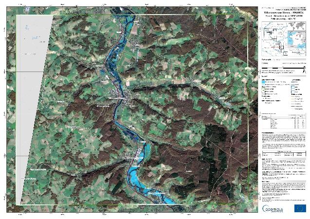
Copernicus Emergency Management Service
 Emergency
Management

        On-demand Mapping                    Early Warning & Monitoring Systems
                                             European Forest Fire &
        Rapid Mapping                        Global Wildfire Information
                     24/7 on-demand          Systems (EFFIS & GWIS)
                     and fast provision
                     of geospatial           European & Global
                     information
                                             Drought Observatory
       Risk & Recovery Mapping
                                             European & Global
                  supporting prevention,
                  preparedness, disaster     Flood Awareness
                  risk reduction,            Systems (EFAS & GloFAS)
                  reconstruction, recovery
E FA S & G l o FA S i n G e n e ra l
 Emergency                 Objectives
Management
      •      Provide users with complementary, added value
             flood forecasts
              •   Probabilistic
              •   Medium-range
              •   River basin wide
      •      Support preparedness for floods at EU and
             global level by providing the ERCC with an
             overview of ongoing and forecasted floods
      •      Knowledge exchange platform for operational
             flood forecasting
      •      Foster collaboration and co-operation between
             the different users
Users
Emergency
Management Who are the users of EFAS?
Mostly national/regional hydro-met
authorities covering almost all WMO Region VI
countries
…but also increasingly civil protection
authorities
Currently: more than 70 EFAS partner
institutions
Who are the users of GloFAS?
national/regional hydro-met authorities,
development agencies, NGO (e.g. Red
Cross), civil protection, intergovernmental
organizations (UN-WFP, OCHA), insurance
Currently: more than 3000 registered,
active users
User feedback & uptake
Emergency EFAS collects:
Management
User feedback after notifications & at the annual meeting
EFAS offers:
twice yearly webinars
Individual partner training
EFAS bulletins with monthly summaries, news and latest developments
EFAS performance evaluation reports for specific events
Annual user workshops
GloFAS offers:
Trainings
Specific GloFAS workshops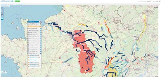
E FA S S e t - u p & P r o d u c t s
Emergency Hydrological model: LISFLOOD
Management
Updated twice daily
Spatial resolution 5km
Medium range, probabilistic, European wide flood forecasts (up to 10 day
lead time)
Multiple weather forecasts (ECMWF, DWD, COSMO-LEPS)
Persistence graphs – return period hydrographs – etc.
Post-processed, bias correct forecasts
Flash flood indicators with a lead time up to 3 days & radar-based flash flood
now-casting
EFAS Flood & Flash Flood Notifications to all partners at river basin level
Monitoring of national flood alert exceedances
Soil moisture, snow maps, anomalies
Hydrological seasonal outlook
Impact forecasts and pre-tasking of Copernicus EMS rapid mapping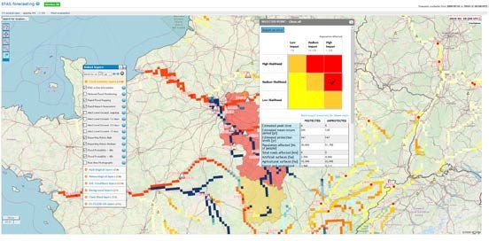
G l o FA S S e t - u p & P r o d u c t s
Emergency
Management Updated daily
Output resolution of 0.1º (~10 km)
Ensemble prediction (ECMWF-ENS)
50+1 members
Forecast lead time of up to 30 days
(medium range plus extended range)
Model cascade: IFS + HTESSEL +
Lisflood
Discharge threshold exceedance based
ERA5 ENS
on 2, 5, and 20 year flood return
Land runoff periods
Persistence diagrams to identify
“jumpiness” over consecutive forecasts
Daily runs since 2011 in pre-
operational mode – since 2018
operational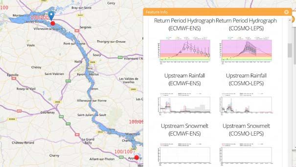
N e w d e v e l o p m e n t s – h y d r. & m e t e o d a t a c o l l e c t i o n
Emergency
Management
Constant increase in meteorological & hydrological data collection!
EFAS collects in-situ data for calibration, validation, monitoring,
post-processing and model initial conditions
Hydrological data:
More than 1300 stations (historic & NRT)
More than 37 data providers
Meteorological data:
Between 4.000 and 10.000 stations depending on the variable
includes gridded datasets
21 different data providers
GloFAS collects in-situ data for calibration and validation
Only Hydrological data:
More than 2000 stations (historic)
More than 37 data providers
GloFAS uses ERA-Interim/ERA5 as meteorological input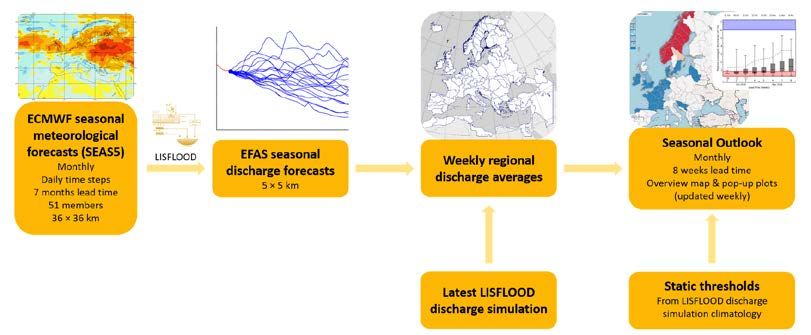
N e w d e v e l o p m e n t s – E FA S ex t e n d e d d o m a i n
 Emergency
Management
        EFAS extended model domain
        •     Released May 2018
        •     Bigger model extent &
              INSPIRE compliant
              projection system
        •     re-done static input maps
              for LISFLOOD
        •     LISFLOOD model updates
        •     Improved meteorological
              data
        •     Improved calibration (704
              stations for calibration
              used)

                                                            9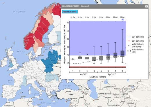
N e w d e v e l o p m e n t s – E FA S w e b i n t e r fa c e
Emergency New EFAS web interface released February 2019
Management
Modern design
Customizable
Adapted for mobile devices
Possibility to add external WMS
Dashboard
Notification feedback integrated + possibility to report a missed eventNew developments – seasonal outlook
Emergency
Management
• river flow anomaly and its
probability of occurrence for
the next 8 weeks for Europe
• To provide a very early
outlook of possible high and
low flows
11I m p a c t b a s e d fo r e c a s t i n g i n E FA S
Emergency Motivation:
Management
• Provide an estimate on affected people, cities, infrastructure & economic
damages based on EFAS forecasts
Approach:
• Linking coarse-scale EFAS flood forecasts with high-res flood hazard maps
• Test using national/regional flood hazard maps instead of EFAS 100m
resolution maps
Flood location & Flood prone Exposure
magnitude areas => potential impact
Flood return
periods
high
medium
lowI m p a c t b a s e d fo r e c a s t i n g i n E FA S
Emergency
Management
Combination of the forecasted flooded area with exposure information to assess the
potential impact
• (forecasted) flooded area
• affected population / major cities / economic damage / major infrastructures (under dev.)
• Not for detailed emergency planning but for having a forecast based estimate of where
the highest impacts are to be expected! 13Linking early warning & rapid mapping
Emergency
Management
Motivation:
• Reduce time for image acquisition (66% of RM workflow)
• Optimise acquisition time with respect to event time
Approach:
• Use EFAS impact forecasts for provision of AOI with high potential
impact to pre-task satellite image acquisition (NO RM activation!)
Map production & delivery (25%)
Satellite data reception & validation (4%)
Satellite tasking & acquisition (66%)
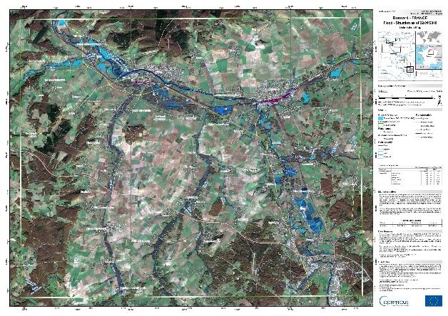
Request handling (5%)France Floods January 2018
Emergency
First EFAS EFAS pre-tasking
Management email
notifications to Satellite image User activates RM First map delivery
SCHAPI 08:00 acquisition 19:00 09:00
18:00
1 2 3 4 5
14 Jan 22 Jan 23 Jan 24 Jan
00:00 12:00 00:00 12:00 00:00 12:00 00:00 12:00
15N e w d e v e l o p m e n t s – G l o FA S v 2 . 0
Emergency
Management
New model version
Implementation on 14 November 2018
Calibrated Lisflood parameters at 1287 river sections
ERA5 based climatological baseline run and thresholds
Hydrological verification suite
Comprehensive probabilistic verification suite (under dev)
Verification against discharge observations and water balance (modelled
discharge at initialisation)N e w d e v e l o p m e n t s – G l o FA S s e a s o n a l
Emergency
Management
Developed by University of Reading and ECMWF
Provides openly available, hydrologically relevant seasonal
forecasts for the global river network
Early indications of high or low river flow, up to 4 months ahead
Emerton et al., 2018, Geoscientific Model Development: GloFAS-Seasonal v1.0D a t a a c c e s s – E FA S & G l o FA S
Emergency
Management
Currently: forecast visualization in the EFAS
& GloFAS web interfaces or through web
map service (WMS)
Ongoing development:
Archived forecasts and climatology for EFAS &
GloFAS available in the Copernicus Climate
Change Climate Data Store and ECMWF MARS
– under development
Raw forecast data available in NRT through an ftp
service (EFAS partners only) – under
development
Raw forecasts data at gauging locations available
through SOS (EFAS) or individual ftp transfer
(GloFAS)F u t u r e d e v e l o p m e n t s – E FA S & G l o FA S
Emergency
Management
Next major update EFAS: Q1/Q2 2020 – includes
improved Lisflood, more calibration stations, 6-hourly
temporal resolution for all forecasts and climatology
Next major update GloFAS: Q4 2019 – includes switch to
full Lisflood, more calibration stations, ERA5 for model
climatology
Global flash flood indicator: ECMWF Ensemble 24h Total
Precipitation Extreme Forecast Index (EFI)
Impact based forecasting for GloFAS: Q3 2019 – same
concept as in EFAS
Lisflood open source: Q2/Q3 2019 – turning Lisflood and
its associated tools into a full open-source code modelThank you!
Copernicus Emergeny Management Service
Annual Meeting
21-22 May 2019
Emergency Stresa, Italy
ManagementYou can also read