Expedition Paddling Race - Muskoka River X
←
→
Page content transcription
If your browser does not render page correctly, please read the page content below
Muskoka River X
                      Expedition Paddling Race
                                     COURSE HERITAGE

The Muskoka River watershed is a vast area stretching from Algonquin Park, east to Georgian
Bay. From the northern lakes of Muskoka around Huntsville to the southern waters around
Gravenhurst. Historically, the Muskoka River watershed was part of the vast territory of the
Algonquin First Nations. It remained pristine and uncharted until war broke out between the
British and Americans.

Following the War of 1812, British expeditions began making their way into this previously
uncharted territory with the goal of finding water routes not vulnerable to American attack. Two
initial explorations in 1819 by Lt. Joseph Portlock and Lt. James Catty made their way into the
Muskoka watershed. A third exploration by Lt. William Marlow and William Smith occurred in
1826. It was not until Lt. Henry Briscue’s 1826 expedition that the Muskoka River was first
recorded in written form. This expedition, traveling north from the Severne River eventually
made their way by canoe into the Algonquin Highlands via the South Muskoka and Oxtonge
Rivers, up to Big Porcupine Lake (Algonquin Park) and east to the Madawaska River. After
several more expeditions occurred throughout 1827 the British Military eventually deemed the
route not appropriate for the construction of a canal.

In 1829 Alexander Shirreff began another expedition, funded by a private company, to build a
canal west from the Ottawa River to Georgian Bay. Shirreff made his way along the Petawawa
River to Tom Thompson Lake (Algonquin Park) and west to the Oxtonge and South Muskoka
Rivers. Although Shirreff did not find a route appropriate for the construction of a canal, he did
find a vast inland waterway of navigable lakes and rivers. The last and best-known canal
expedition was led by David Thompson in 1837.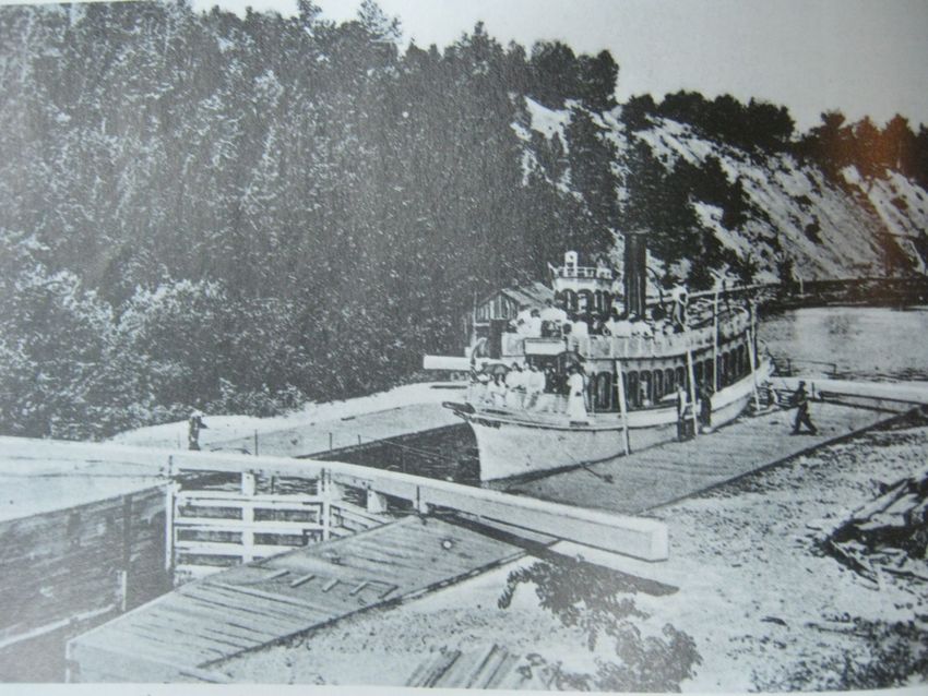
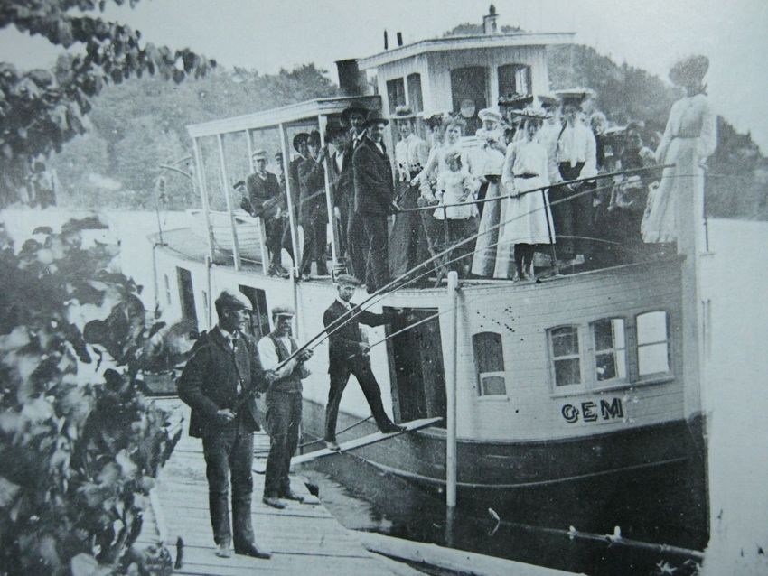
Although these expeditions were unsuccessful in locating a canal route, they did bring attention
to the Muskoka watershed, resulting in expansion into this area with railroads, logging, frontier
towns, steam ships and grand resorts; all that continue to this day.

The era of steam ships in Muskoka began when Alexander Cockburn launched the Wenonah in
1866, traveling Lake Muskoka north from Gravenhurst up the Muskoka River to Bracebridge.
Other notable ships that traveled this route include the Nipissing, launched in 1887 and the
Sequwin in 1925.

The northern waters of the Muskoka River watershed saw steam ship travel begin in 1877 with
the launch of the Northern. This steamer route originated from Port Sydney, where Mary Lake
empties into the North Muskoka River, traveling north to Huntsville. Other notable steamers that
traveled this route include the Florence in 1884, the Gem, and the SS. Joe (1900). The route
from Port Sydney to Huntsville was made possible with the construction of the Huntsville Lock
between 1873-1875.

Steam ship travel on Lake of Bays began in 1878 when Alexander Cockburn sold his steamer,
the Waubamik, to Joseph Huckins who then renamed it the Dean. From Baysville, the steamer
traveled Lake of Bays servicing ports of call such as Dwight, Portage, and the ever-increasing
grand resorts. Other notable steamers on the Lake of Bays include the Helna (1884), Empress
Victoria (1894), Excelsior, Erastus Wiman, Phoenix (1901), and the Hamilton H.
The Huntsville Navigation Company was started in 1884 by George March with the launch of
the Mary Louise. The dredging of the canal between Fairy Lake and Peninsula Lake between
1886-1888 allowed steam ships to travel the full system of lakes of northern Muskoka including
Peninsula, Fairy, and Vernon. With the canal, ships such as the flagship Algonquin (1906-1927)
and the Ramona transported goods and people from Portage to Huntsville, and all points
between. They also supported the development of Deerhurst Resort in 1896, the grand resort of
the Huntsville area. With the development of the Huntsville and Lake of Bays Transportation
company in 1895, the wagon and coach link between Lake of Bays and Peninsula Lake was
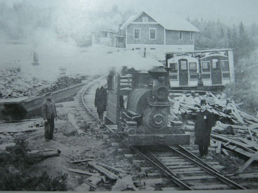
eventually replaced by the small gauge railroad, the Portage Railway, which operated between
1904 and 1959.
It is these First Nations routes into their hunting and fishing grounds, and the routes of canal
expeditions, steamers, and railroads, that teams will travel along.
References:
Long, Gary. (1989). This River. The Muskoka. The Boston Press: Erin, Ont. ISBN 1-55046-012-9
Tatley, Richard. (1983). The Steamboat Era in the Muskokas. The Boston Pess: Erin, Ont. ISBN 0-919822-50-9 (vol.1)
MUSKOKA RIVER X COUREUR des BOIS
Start: Whitney, Ontario
Finish: River Mill Park: Huntsville, Ontario
Total Distance: 220km
Number of Portages: 36 (approx 11,800m / longest: 1700m)
Estimated Duration: 26 hours to 48 hours
MUSKOKA RIVER X CLASSIC
Start: River Mill Park: Huntsville, Ontario
Finish: River Mill Park: Huntsville, Ontario
Total Distance: 130 km
Number of Portages: 20 (approx 7000m / longest: 1700m)
Estimated Duration: 13.5 hours to 24 hours
Sunrise: 0653hrs Sunset: 1937hrs Total daylight: 12hrs 44min
Average Daily Temperatures
High: 18.8 degrees Celsius Low: 6.5 degrees Celsius Average: 12.7 degrees Celsius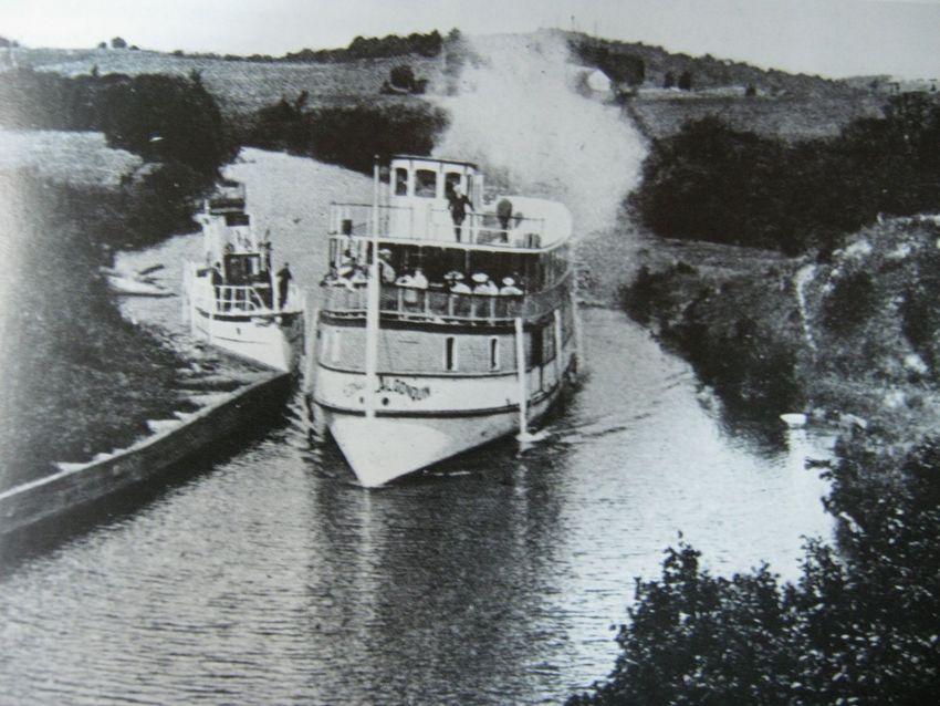
Other Weather Statistics
Average Daily Wind speed: 12km/hr
Average Monthly Rain: 111mm
Average Days with Thunderstorms: 3
Average Days with Fog: 5

MRX Coureur des Bois Stage: 89km
Whitney to Oxtongue Lake
The River X crew is excited to announce an expansion course to the Muskoka River X Classic. Building
on the heritage of the canal expeditions of the 1800’s, the Coureur des Bois will challenge even the most
experienced expedition and marathon paddlers. Teams will paddle the routes of the canal expeditions
leaving Whitney and traveling west through Galeairy, Rock, and Whitefish Lake. After traversing Lake
of Two Rivers, teams will make their way to Cache and Smoke Lake. From Tea Lake teams navigate
downriver on the Oxtongue River before finishing Day One with a long and exhausting portage around
the mighty Ragged Falls. With 89km and 16 portages (4800m) under their belts, the Coureur des Bois
will enjoy a mandatory overnight at Oxtongue Lake. Day 2 will begin with an early morning shuttled to
Dwight beach at the northern most point of Lake of Bays. Paddling past Portage Bay the Coureur des
Bois will merge with the MRX Classic teams. From here, Coureur des Bois teams will finish the MRX
Classic Stage 1 at Baysville and continue on with Stages 2, 3, and 4. Traversing the wilderness of
Algonquin Park and circumnavigating the Muskoka River system, the Coureur des Bois is truly the
ultimate in backcountry expedition racing.

MRX Classic Stage 1: 33.5km
Huntsville to Baysville
Stage 1 is primarily lake paddling. The race will start in downtown Huntsville at the River Mill Park.
Paddling east along the Muskoka River into Fairy Lake, teams will continue east into the canal that links
Fairy and Peninsula Lakes. As teams pass the legendary Deerhurst Resort, they will continue paddling east
to the take-out at Wolfbay Road. At Wolfbay Road teams will portage 1700m from North Portage
(Peninsula Lake) to South Portage (Lake of Bays). From South Portage, teams will paddle 20km south on
the large and expansive Lake of Bays, arriving at Baysville. Baysville is location of Checkpoint #1 and
ends with a 218m portage around the Baysville dam.

Consistent with seasonal weather, you may experience early morning mist or fog making navigation
challenging. By the time teams reach Lake of Bays, expect the wind to have increased; head winds are
common when leaving South Portage and the exposure of Lake of Bays also brings risk and challenge
associate with wind and wave.

MRX Classic Stage 2 (45.7km)
Baysville to Bracebridge
Stage 2 is entirely downriver. Teams will leave Baysville and paddle the South Muskoka River, arriving
at the historic town of Bracebridge, the location of Check Point #2. Not only is Stage 2 the longest
section of the race, it is also the most physically demanding. Included in Stage 2 are at least 11 portages
ranging from a few meters to a 1283m portage around the Muskoka Falls hydro dam. The first 10km of
the river will present teams with numerous opportunities to line their boats or portage over shallow, swift
moving rocky rapids. The remainder of the river is wider, deep and slow moving, although the presence
of westerly wind may be a factor later in the day.

MRX Classic Stage 3 (29.8km)
Bracebridge to Port Sydney
Stage 3 is entirely upriver paddling. Teams will leave Bracebridge, paddle north along the North
Muskoka River and arrive at the small town of Port Sydney. Although the North Muskoka River is
generally wide and slower moving, expect overall padding speed to be reduced by 1-2km/hrs as a result of
the current. Additional features that make Stage 3 physically demanding include 5 portages, most notably
a rugged 360m, 65 vertical feet uphill portage around High Falls. Teams will also be faced with portages
over the rocky faces of Balsam and Duck Chutes, both with put-ins against current. Stage 3 finishes with
a 650m portage ending at the Port Sydney dam where Mary Lake feeds the North Muskoka River. As the
day moves on, teams will be racing against impending darkness and the challenges associated with
navigating at night.

MRX Classic Stage 4 (19.4km)
Port Sydney to Huntsville
Stage 4 is a mix of flat-water lake and river paddling. Teams will depart Port Sydney and paddle north on
Mary Lake to where it is fed by the North Muskoka River. Teams will paddle up-river, portaging around
the Huntsville Locks and into Fairy Lake. From Fairy Lake, teams will make their way north into the
Muskoka River and the Finish Line at the River Mill Park. Although stage 4 is the least demanding of the
all sections, most, if not all teams will be completing stage 4 under the cover of darkness and will be
navigating by headlamp, compass, and map.

Historical References and Links
http://en.wikipedia.org/wiki/Huntsville_and_Lake_of_Bays_Transportation_Company#Steamboats
http://www.loba.ca/wp-content/uploads/2011/08/A-Link-to-the-Past-SS-Bigwin.pdf
http://www.portageflyer.org/
http://www.lakeofbaysheritage.ca/resources/heritagebooks
http://yaktraveller.blogspot.com/2010/05/trip-4-south-muskoka-river-there-and.html
http://www.myccr.com/canoedb/routeDetails.php?routeid=38
http://www.theheartofmuskoka.com/main4.cfm?id=0BB15F81-920A-39DE-82C57529359D1436
http://www.muskokaoutfitters.com/active/activity-page.php?activity=Canoeing
http://www.thecanadianencyclopedia.com/articles/david-thompson
http://www.encyclopediecanadienne.ca/articles/huntsville
http://www.thecanadianencyclopedia.com/PrinterFriendly.cfm?Params=A1ARTA0005568
http://www.encyclopediecanadienne.ca/articles/bracebridge
http://images.ourontario.ca/muskoka/43956/data
You can also read