FABCOT PROPOSED WOOLWORTHS SUPERMARKET MARMION AVENUE / NEERABUP ROAD, MINDARIE TRAFFIC AND PARKING ASSESSMENT - V1 22 March 2021
←
→
Page content transcription
If your browser does not render page correctly, please read the page content below
FABCOT

              PROPOSED WOOLWORTHS SUPERMARKET
            MARMION AVENUE / NEERABUP ROAD, MINDARIE
                 TRAFFIC AND PARKING ASSESSMENT

                                    March 2021

                                Riley Consulting Pty Ltd
                                 PO Box Z5578
                                 Perth WA 6831
                               0413 607 779 Mobile

Issued on      22 March 2021                Amendment      Date
Version        V1
Reference      1085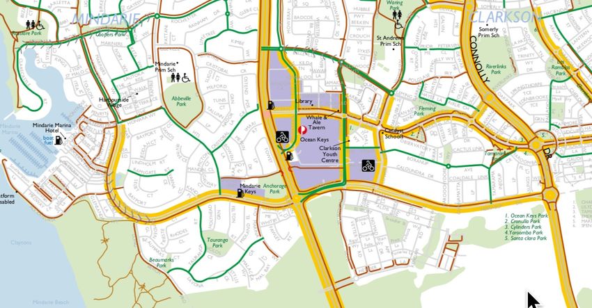
Woolworths Mindarie
                                                                                               T raffic and T ransportation Consultants
CONTENTS

1.    EXECUTIVE SUMMARY ................................................................................................................ 3

2.    CHECKLIST .................................................................................................................................. 4

3.    THE SITE AND SURROUNDING ROAD NETWORK ........................................................................ 5

4.    THE PROPOSED DEVELOPMENT .............................................................................................. 10

5.    TRAFFIC GENERATION AND DISTRIBUTION .............................................................................. 12

6.    DAILY TRAFFIC IMPACT ............................................................................................................. 15

7.    PEAK HOUR IMPACT ................................................................................................................. 15

8.    ACCESS ..................................................................................................................................... 17

9.    PARKING................................................................................................................................... 20

10.    PUBLIC TRANSPORT, PEDESTRIANS AND CYCLISTS .................................................................. 22

11.    ROAD SAFETY ......................................................................................................................... 23

12.    CONCLUSIONS ........................................................................................................................ 23

                                                                                                                                  Page 2 of 33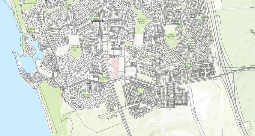
Woolworths Mindarie
                                                              T raffic and T ransportation Consultants
1. EXECUTIVE SUMMARY
        1.1.     Riley Consulting has been commissioned by Fabcot Pty Ltd to prepare a
                 traffic report for a proposed Woolworth’s supermarket with liquor store and
                 speciality retail at 19 Neerabup Road, Clarkson (Mindarie). The key findings of
                 the traffic review are:
                 1.1.1.   The proposed development of a Woolworths supermarket on the
                          subject site will replace an existing Woolworths supermarket located
                          to the southern end of the Ocean Keys Shopping Centre. The
                          entrances of the two stores are in the order of 100 metres apart.
                 1.1.2.   As the car parks share the same access roads, the proposed store
                          will re-distribute traffic accessing the existing store. Based on the
                          RTA Guide to Traffic Generating Developments, the proposed store
                          could increase local traffic by 1,313 movements per day. During the
                          Thursday evening peak an additional 128 vehicle movements are
                          forecast.
                 1.1.3.   The forecast traffic generation has an increase of less than 10% to
                          the affected surrounding road network capacity and under the WAPC
                          Transport        Assessment   Guidelines    for     Developments,              the
                          development would be deemed to have no material traffic impact.
                 1.1.4.   Under the WAPC guidelines, local intersections are not materially
                          affected based on the forecast traffic increases to road approaches
                          and turning lanes.
                 1.1.5.   Assessment of the proposed access to the site indicates that
                          acceptable Levels of Service can be expected during peak periods of
                          site activity.
                 1.1.6.   Analysis of the surrounding road network indicates that adequate
                          capacity exists to accommodate the proposed development. All
                          affected intersections are shown to continue to operate in an
                          acceptable manner.
                 1.1.7.   Appropriate car parking is provided for the proposed development.

                                                                                           Page 3 of 33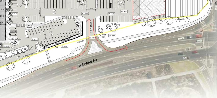
Woolworths Mindarie
                                                                        T raffic and T ransportation Consultants
2. CHECKLIST
ITEM                                                   PROVIDED   COMMENTS/PROPOSALS
Summary                                                   ✔
Introduction/Background                                   ✔
name of applicant and consultant                          ✔
development location and context                          ✔
brief description of development proposal                 ✔
background information                                    ✔
Existing situation                                        ✔
existing site uses (if any)                               ✔
existing parking and demand (if appropriate)                      N/A
existing access arrangements                              ✔
existing site traffic                                     ✔
surrounding land uses                                     ✔
surrounding road network                                  ✔
traffic management on frontage roads                      ✔
traffic flows on surrounding roads (usually AM and        ✔
PM peak hours)
traffic flows at major intersections (usually AM and      ✔       Thursday PM
PM peak hours)
operation of surrounding intersections                            No material change
existing pedestrian/cycle networks                        ✔
existing public transport services                        ✔
crash data                                                ✔
Development proposal                                      ✔
proposed land uses                                        ✔
table of land uses and quantities                         ✔
access arrangements                                       ✔
parking provision                                         ✔
end of trip facilities                                    ✔
intersection layouts and controls                         ✔
pedestrian/cycle networks and crossing facilities         ✔
public transport services                                 ✔
Integration with surrounding area                         ✔
surrounding major attractors/ generators                  ✔
committed developments and transport proposals            ✔
proposed changes to land uses within 1200 metres          ✔
adequacy of existing transport networks                   ✔
deficiencies in existing transport networks               ✔
remedial measures to address deficiencies                 ✔
Analysis of transport networks                            ✔
assessment years                                          ✔
time periods                                              ✔
development generated traffic and distribution            ✔
parking supply and demand                                 ✔
base and ‘with development’ traffic flows                 ✔
analysis of development accesses impact on                ✔
surrounding roads impact on intersections
road safety                                               ✔
public transport access                                   ✔
pedestrian / cycle access/amenity                         ✔
Conclusions                                               ✔

                                                                                                     Page 4 of 33
Woolworths Mindarie
                                                                T raffic and T ransportation Consultants
3. THE SITE AND SURROUNDING ROAD NETWORK
    3.1.      Riley Consulting has been commissioned by Fabcot to consider the traffic and
              transport impacts of developing a Woolworth’s supermarket on the corner of
              Marmion Avenue and Neerabup Road, Mindarie.
    3.2.      Figure 1 indicatively shows the site location.

Figure 1        Site Location (PlanWA)

    3.3.      The subject site is located at 19 Neerabup Road, Clarkson. The subject site is
              the corner lot between Marmion Avenue and Neerabup Road.
    3.4.      The site was previously occupied by a Bunning’s warehouse, which relocated
              further east on Neerabup Road.
    3.5.      Roads of importance to the proposed development are discussed below.
    Marmion Avenue
    3.6.      Marmion Avenue is classified as a distributor type A road in the Main Roads
              Functional Road Hierarchy. It is constructed as a four lane divided road for the
              majority of its length. It has a posted speed limit of 80kph.
    3.7.      Traffic data available on the Main Roads web site indicates 22,935 vehicles per
              day (vpd) to the north of Neerabup Road and 23,896vpd south of Portofino
              Promenade. The data is attached at Appendix A. During the weekday, MRWA
              traffic data indicate 1,878 vehicles in the evening peak compared to the weekend
              peak of 1,729 vehicles.

                                                                                             Page 5 of 33
Woolworths Mindarie
                                                               T raffic and T ransportation Consultants
    3.8.      Reference to Appendix B indicates Marmion Avenue would be considered to
              have capacity for 40,500vpd operating at Level of Service D. Higher traffic
              demands would be possible, but are undesirable.
    3.9.      Footpaths are provided to both sides of Marmion Avenue.
    Neerabup Road
    3.10.     Neerabup Road is classified as a distributor type A road in the Main Roads
              Functional Road Hierarchy. It is constructed as a four lane divided road and
              provides access between Marmion Avenue and the Mitchell Freeway. It has a
              posted speed limit of 70kph.
    3.11.     Traffic data on the Main Roads website shows 18,295vd west of Marmion
              Avenue. The data is attached at Appendix A.
    3.12.     Traffic signals control the intersection of Key Largo Drive / McAlister Boulevard.
    3.13.     Neerabup Road would also have capacity to carry 40,500vpd operating at Level
              of Service D.
    3.14.     Footpaths are provided to both sides of Neerabup Road.
    Key Largo Drive
    3.15.     Key Largo Drive is classified as a local distributor road in the Main Roads
              Functional Road Hierarchy. It is constructed with a single pavement comprising
              two traffic lanes, with an additional southbound lane approaching the traffic
              signals at Neerabup Road.
    3.16.     Traffic data extracted from the MRWA traffic signal loops at Neerabup Road
              indicates a demand of about 10.500vpd. As a single carriageway road it would
              have capacity to carry 13,500vpd at Level of Service D (Appendix B).
    3.17.     Key Largo Drive provides the main southern entry to the Ocean Keys shopping
              centre.
    3.18.     A footpath is provided to the western side of Key Largo Drive (adjacent to the
              subject site).
    Pensacola Terrace (Northern Access Lane)
    3.19.     Pensacola Terrace is classified as a local distributor in the Main Roads
              Functional Road Hierarchy. It is constructed with a single pavement of
              approximately 7.2 metres. It has a posted speed limit of 50kph.
    3.20.     Pensacola Terrace provides access to and from Marmion Avenue to the south
              side of the Ocean Keys shopping centre and links to Key Largo Boulevard.
              Movements at Marmion Avenue are restricted to left in / left out.
    3.21.     A roundabout controls is intersection with the northern access road linking back
              to Key Largo Drive and provides access to the shopping centre car parks and the
              subject site.

                                                                                            Page 6 of 33
Woolworths Mindarie
                                                               T raffic and T ransportation Consultants
    3.22.     No traffic data is available for Pensacola Terrace. A peak hour count to the rear
              of the existing Woolworths store indicated 205 movements. This suggests the
              lane to the north of the subject site is carrying about 2,000vpd.
    3.23.     As a single lane road a capacity of 13,500vpd would be provided based on
              operation at Level of Service D. The spur leading to the subject site is not
              included in the hierarchy and is provided with a 6 metre wide pavement.
    Anchorage Drive
    3.24.     Anchorage Drive is classified as a local distributor road in the Main Roads
              Functional Road Hierarchy. It is constructed as a four lane divided road between
              Marmion Avenue and Ocean Falls Boulevard. It has a posted speed limit of
              60kph.
    3.25.     Traffic data available on the Main Roads web site indicates 16,749vpd to the
              west of Marmion Avenue (2020/21). The traffic data is attached at Appendix A.
    3.26.     Based on Appendix B it is estimated that Anchorage Drive would have capacity
              to carry 36,000vpd operating at Level of Service D.
    Crash Data
    3.27.     Reference to MRWA crash data indicates that the roundabout at the intersection
              of Marmion Avenue and Neerabup Road has experienced 101 crashes in the
              past 5 years. The data shows that rear end crashes are most common (48.5%)
              with right angle movements comprising 23% of the total. Four crashes have
              required hospital attention and 57% of crashes have resulted in major damage.
              There have been no fatal crashes.
    3.28.     The intersection of Marmion Avenue / Pensacola Terrace has experienced 2
              damage only crashes in the past 5 years.
    3.29.     The intersection of Neerabup Road and Key Largo Drive has experienced 42
              crashes in the past 5 years. 74% of crashes are right turning movements. 3
              crashes have required hospital attendance. There have been no fatalities.
    3.30.     It is hard to quantify if the proposed supermarket development would lead to an
              increase in crashes on the local road network. The proposed supermarket will
              attract patronage from the local area who are already using the local roads to
              access the existing store close-by. Given the increase to more localised trips, it is
              considered that the proposed supermarket would not be expected to impact local
              road safety in a detrimental manner.
    Other Development
    3.31.     The subject site is one of the last land parcels available for large scale
              development in the local area. A Bunning’s warehouse formally occupied the site.

                                                                                            Page 7 of 33
Woolworths Mindarie
                                                              T raffic and T ransportation Consultants
    3.32.     In 2018 GTA prepared a structure plan traffic report for the subject land based on
              the development of 10,000m2 of commercial land uses.
    3.33.     To the south of Neerabup Road a new residential precinct is under construction
              that will continue to increase local traffic demands, of which the new
              development will attract home-based trips.
    Public Transport
    3.34.     Reference to the Transperth web site indicates there are 2 bus services
              operating adjacent to the subject site. The bus service, route 474, operates along
              Marmion Avenue between Clarkson railway station and Joondalup town centre. It
              operates on an hourly basis Monday to Friday.
    3.35.     Route 481 operates on Marmion Avenue and Anchorage Drive between Clarkson
              railway station and Quinns Rocks. It operates on a half hourly basis during the
              week and hourly at weekends.
    3.36.     Figure 2 shows the local bus services.

Figure 2        Local Bus Services

    Cycling
    3.37.     An acceptable cycling environment exists in the Mindarie precinct, with on-street
              cycle lanes provided to Marmion Avenue and Neerabup Road.

                                                                                           Page 8 of 33
Woolworths Mindarie
                                                               T raffic and T ransportation Consultants
    3.38.     A cycle route is provided to the north of the subject site to access the underpass
              to Marmion Avenue, creating a safe link between the residential area and the
              Ocean Keys shopping precinct.
    3.39.     Figure 3 shows the local cycling network.

Figure 3        Local Cycling Network

    Changes to Surrounding Transport Networks
    3.40.     There are no changes currently proposed to the local road network that would
              affect the proposed development.
    3.41.     An approved development is located to the south side of Neerabup Road that will
              see continued residential expansion. However, the locality of Mindarie is close to
              full development.
    Integration with Surrounding Area
    3.42.     The site is located at the southern edge of Ocean Keys shopping centre and fits
              well with surrounding development.
    3.43.     The site has been previously used as a Bunning’s warehouse and higher levels
              of traffic attraction are consistent with the previous and proposed land uses. It is
              calculated that the Bunning’s store had a floor area of about 9,500m2.
    Assessment Years and Time Periods
    3.44.     The proposed development is considered for the year of opening.
    3.45.     Shopping centres traditionally experience peak demand on Thursday evenings
              between 5pm and 6pm and Saturday mornings between 11am and 12pm.
    3.46.     Reference to local traffic data indicates that Marmion Avenue and Neerabup
              Road experience peak demands between 3pm and 4pm during the week and
                                                                                            Page 9 of 33
Woolworths Mindarie
T raffic and T ransportation Consultants
12pm to 1pm at the weekend. It can be seen that the road network peak does not
coincide with the peak demand of the proposed development.
3.47. However, reference to Ocean Keys Boulevard traffic signals data suggests the
town centre peaks between 5pm and 6pm on a Thursday and then 1pm to 2pm
on a Saturday. However, traffic demands on the surrounding road network are
approximately 10% lower during the Saturday peak suggesting that acceptable
operation during the Thursday PM peak will equate to acceptable operation
during the Saturday peak.
3.48. For the purpose of traffic assessment the Thursday evening peak between 4pm
and 5pm is used, as local road network traffic demands are slightly higher than
the 5pm-6pm peak of the proposed development.
3.49. As the proposed development is a relocation of an existing adjacent
supermarket, long term planning horizon assessment is not considered to be
necessary.
4. THE PROPOSED DEVELOPMENT
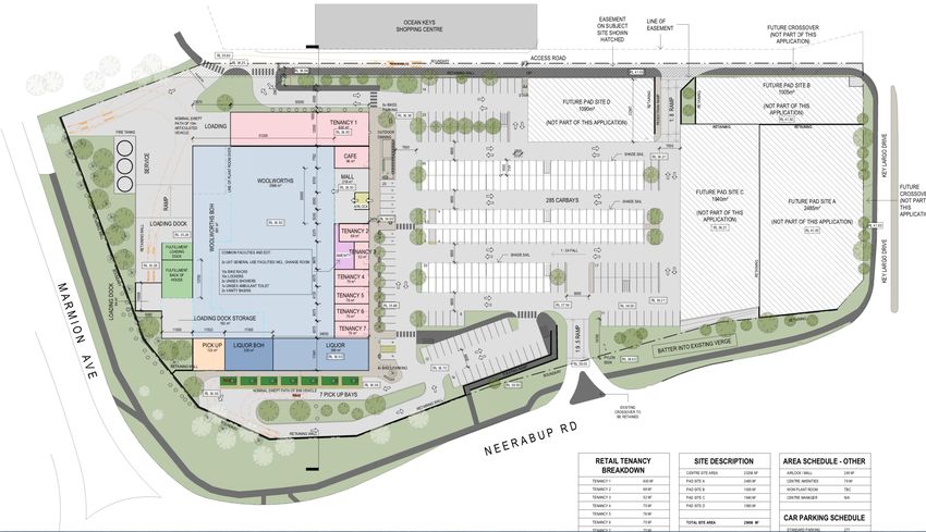
4.1. It is proposed to develop the site to provide a Woolworths supermarket, a liquor
store and speciality retail opportunity. In total a gross floor area of 5,663m2 is
expected. At grade parking is to be provided with access to Neerabup Road and
the northern service lane.
4.2. It is noted that the site plan indicates pad sites fronting Key Largo Boulevard and
the northern access lane. The pad sites are indicative of possible future uses, but
do not form part of the development application.
4.3. Figure 4 shows the indicative concept plan for the site. Refer to the development
application plans for detail.
Page 10 of 33Woolworths Mindarie
T raffic and T ransportation Consultants
Figure 4 Site Layout Extract (refer to DA Plans)
Page 11 of 33Woolworths Mindarie
T raffic and T ransportation Consultants
5. TRAFFIC GENERATION AND DISTRIBUTION
5.1. The proposed development will relocate an existing Woolworths supermarket in
Ocean Keys shopping centre to an adjacent site formally occupied by a
Bunning’s warehouse.
5.2. It would be normal in a traffic assessment to remove the previous use traffic
generation of the site prior to distributing the traffic generated by the proposed
development. However, in this instance, the old use of the site ceased many
years ago and the use relocated further east on Neerabup Road. Therefore the
previous use traffic is still on the local road network.
5.3. As the development will relocate an existing supermarket, it is appropriate to
consider the existing supermarket traffic on the surrounding road network.
However, it could be argued that the relocation of the store would actually have
no traffic increase as customers are on the road network accessing the site next
door. The relocation would only result in a redistribution of traffic on the network
to the new access and egress points.
5.4. For the purpose of this traffic study, the existing supermarket floor area is used to
identify the expected existing traffic demands and the new store floor area is
used to identify what traffic increase could be anticipated. The difference
between the two floor areas is distributed over the local road network to identify
any potential traffic impacts.
Existing Supermarket
5.5. The Woolworths supermarket in the Ocean Keys shopping centre has a floor
area of 3,647m2 and has a primary access from a car park situated off Pensacola
Terrace and a rooftop car park accessed from the northern lane (to the subject
site). It is anticipated that the majority of shoppers to Woolworths will use these
access points during peak trading periods.
Trip Rates
5.6. For the purpose of the traffic assessment, reference is made to the RTA (NSW)
Guide to Traffic Generating Developments (RTA Guide). Whilst the guide is now
old (2002) and is not reflective of current trading, it is perhaps still the most
reliable source for mixed uses within an Australian shopping centre.
5.7. The formula within the guide is used to identify the peak hour shopping centre
trip rates for the various land uses to assist an understanding of how traffic
demands can be expected to change. The model suggest:
• Thursday V=155(supermarket) + 46 (speciality) / 1,000m2 GLFA
• Saturday V=147 (supermarket) + 108 (speciality) / 1,000m2 GLFA
• Daily V=1475 (supermarket) + 555 (speciality) / 1,000m2 GLFA
Page 12 of 33Woolworths Mindarie
T raffic and T ransportation Consultants
5.8. The RTA Guide advises that generation rates given are based on (GFLA) which
provides a better indication of trip generation than gross floor area. As a general
guide, the RTA advises that 100m2 gross floor area equals 75m2 gross leasable
floor area. These factors are applied to the Gross Floor Areas advised by the
architect.
Existing Store
5.9. The existing store has a gross floor area of 3,647m2, which equates to an area of
2,735m2 GLFA. Based on the RTA model the existing supermarket would be
expected to generate:
Thursday PM peak 424 trips
Saturday Peak 402 trips
Daily 4,034 trips
Proposed Development
5.10. The proposed development will comprise of a Woolworths supermarket with a
liquor store, speciality outlets and a cafe. The gross floor areas are as follows:
• Supermarket 3,814m2
• Liquor Store 599m2 (inc BoH)
• Tenancies 1,117m2
• Total net area 5,663m2
5.11. As applied to the existing store, the gross floor areas are factored to reflect the
GLFA. The liquor store is considered as supermarket floor area, which will tend
to over estimate the potential traffic attraction (particularly when 200m2 is a store
room). The derived RTA GLFA floor areas for the purpose of trip generation are;
Supermarket (food and liquor) 3,309m2 Speciality 837m2. Applying the RTA
formula indicates the following traffic generation:
• Thursday PM peak 552 trips
• Saturday Peak 576 trips
• Daily 5,347 trips
Pass-by Trade
5.12. Reference to Austroads suggests that a supermarket / shopping centre can
attract 50% of patronage from traffic already passing the site.
5.13. In regard to the proposed development, it is feasible that all traffic is already
passing the site accessing the existing store and other local stores, as the local
area is an expanding residential precinct.
5.14. Structure planning of new residential areas would have forecast appropriate trips
to the town centre.
Page 13 of 33Woolworths Mindarie
T raffic and T ransportation Consultants
5.15. For the purpose of this traffic report, no pass-by trips are assumed and the
difference in traffic between the existing store and the new store will be assumed
as new trips.
Resultant Traffic Generation
5.16. Table 1 shows the forecast traffic generation of the proposed development and
the resulting new trips that could access the local road network.
Table 1 Forecast Traffic Generation
Land Use Daily trips PM Peak Saturday peak
Existing Supermarket 4,034 424 402
Development 5,347 552 576
New Trips +1,313 +128 +174
Distribution and Assignment
5.17. Traffic attracted to the proposed supermarket will be drawn from the surrounding
residential dwellings and from traffic using the Mitchell Freeway during the peaks.
5.18. As discussed, a Woolworths store is located to the north side of the northern
access road and assessment of the traffic using that store and the existing peak
traffic movements associated with Ocean Keys shopping centre has been
undertaken.
5.19. Based on the data available, Table 2 shows the derived peak hour distribution.
The assumptions have been applied to the existing store and the new store to
determine the expected traffic increases to the surrounding road network.
Table 2 Distribution Assumptions (Peak Hours)
Peak Movement North South East West
Thursday Arrive 36% 20% 31% 13%
Depart 52% 6% 28% 14%
Saturday Arrive 43% 20% 31% 6%
Depart 52% 1% 28% 19%
Average 46% 12% 30% 13%
Page 14 of 33Woolworths Mindarie
T raffic and T ransportation Consultants
6. DAILY TRAFFIC IMPACT
6.1. Reference to the WAPC Transport Assessment Guidelines for Developments -
(Volume 4) states that:
“where a traffic increase as a result of a proposed development is less than 10%
of current road capacity, it would not normally have a material impact”.
6.2. Table 1 shows the expected traffic increase as a result of the existing store
relocating to the new site. In total it is calculated that the new store will generate
an additional 1,313 vehicle movements per day to the surrounding road network.
6.3. Table 3 provides an assessment of the impact that the forecast traffic increases
may have. The forecast is based on the impact to the roads operational capacity
at Level of Service D. In reality the actual capacity is as shown in Appendix B for
a Level of Service F.
Table 3 Daily Increases to Local Road Network
Road Increase Capacity % Capacity
Marmion Avenue north 341 40,500 0.84%
Marmion Avenue south 105 40,500 0.26%
Anchorage Drive 171 40,500 0.42%
Neerabup Road 420 40,500 1.04%
Key Largo Drive 263 13,500 1.94%
The increase of 13 vehicles to McAlister Boulevard is not shown above as structure planning will have accounted
for shopping trips on this link.
6.4. It can be seen from Table 3 that the traffic increases to the surrounding road
network are less than 10% of the capacity at a Level of Service D and therefore
would be considered to have no material traffic impact based on the WAPC
Transport Assessment Guidelines for Developments.
6.5. It is concluded that from a daily traffic flow perspective the proposed
development can be accommodated by the local road network.
7. PEAK HOUR IMPACT
7.1. The assessment of the proposed development is shown to have little material
traffic impact based on the change to daily traffic flows when measured against
the WAPC guidelines.
7.2. During the peak periods of development activity, some impacts may occur to
local intersections.
Page 15 of 33Woolworths Mindarie
T raffic and T ransportation Consultants
7.3. Reference to the WAPC Transport Assessment Guidelines for Developments -
(Volume 4) states that the traffic assessment should cover “all intersections
where flows on any leg would increase by 10 per cent, or any movement by 20
per cent.
7.4. Traffic demand plans have been created to distribute the peak hour movements
of the existing store and the proposed new store. The plans have been used to
identify the expected change to turning movements at affected intersections. The
forecast changes are shown in Appendix D for the Thursday and Saturday
peaks.
7.5. The largest change to traffic demands is the increase to vehicles entering the
store from Neerabup Road as would be expected. Changes to existing
intersection approaches and turning movements are considered in Table 4 below
and are shown in Appendix D. The table considers the highest change in any
traffic movement.
Table 4 Peak Intersection Changes
Approach Increase Flow % Change
Neerabup Rd Eastbound +80 811 9.8%
Key Largo Drive northbound +17 395 4.3%
Marmion Avenue Northbound +15 1,480Woolworths Mindarie
T raffic and T ransportation Consultants
the LoS (noting that RTA LoS criteria would retain LoS D). The movement
summary is included in Appendix D.
7.10. Assessment of possible signal phasing changes indicates that the approach
Levels of Service could be maintained. However, as Mindarie is still expanding to
the south with new residential development, it can be expected that future
changes to the traffic signals will be required regardless of the subject site
development.
8. LONG-TERM ASSESSMENT
8.1. As the proposed development is shown to have no material traffic impact, it is
considered that no long-term assessment is required.
8.2. It is noted that the proposed development of a Woolworths supermarket and
speciality retail will replace an existing Woolworths supermarket within the Ocean
Keys shopping centre. As a result, a new tenant for the vacant floor area in the
shopping centre will be sought.
8.3. At this time it is speculation as to the future tenant, however, given that both
major food retailers are represented in the locality, it is unlikely that a food retailer
would lease the site. On this basis, a lesser traffic generating land use such as a
discount or department store type land use is perhaps most likely.
8.4. Reference to the RTA guide suggests that during the peak periods, land uses
such as discount and speciality stores generate about 70% less traffic than a
supermarket. A department store is indicated to generate about 87% less traffic
than a supermarket.
8.5. It is speculated that should a discount type store (such as target) occupy the old
Woolworths store site, the level of new traffic, particularly in the peak hour, would
be minimal. With major outlets already present in the shopping centre, a new
outlet will attract a significant level of reciprocal attraction to existing stores. It is
also noted that residential development is not completed and additional traffic
attraction will be occurring over the coming years regardless of any land use
changes.
9. ACCESS
9.1. Access to the proposed store will be taken using the existing cross over to
Neerabup Road and relocating the existing crossover to the northern lane and
providing an additional cross over to the northern lane at its western end.
Page 17 of 33Woolworths Mindarie
T raffic and T ransportation Consultants
9.2. The access to Neerabup Road is restricted to left-in /left-out movements and was
created for the previous use of the site (Bunning’s). The access is appropriately
located in regard to separation to Marmion Avenue and Key Largo Drive. An
existing left turn slip lane is provided for the access and a median splitter island
to prohibit right turn movements. Analysis of the access indicates that Level of
Service A is provided to all traffic movements (refer Appendix D Sidra network
plan).
9.3. Access to Neerabup Road is shown in Figure 5.
Figure 5 Access to Neerabup Road
9.4. Access to the northern lane will create a new straight access approach to the
northern lane. The access is being located approximately 70 metres west of Key
Largo Drive and will provide far greater separation than the existing access.
Further, the existing tight bends on the access will be removed to provide safer
entry and exit to the subject site. The proposed access will be located about 15m
west of the shopping centre service yard access and is in accordance with
AS2890.1.
9.5. Analysis of the access to the lane indicates that during peak periods Level of
Service A is provided to all movements. No interaction with Key Largo Boulevard
is shown to occur refer Appendix D Sidra network plan).
9.6. The access is shown in Figure 6.
Page 18 of 33Woolworths Mindarie
T raffic and T ransportation Consultants
Figure 6 Access the Northern Lane
9.7. A new access to the northern access lane is proposed adjacent to the service
area access. The access will provide convenient access to and from Marmion
Avenue and is in close proximity to the existing Woolworths basement car park.
The access location is convenient for shopping centre customers to access the
Woolworths car park.
9.8. Visibility in accordance with AS2890.1 is provided at all access locations.
Service Vehicle Access
9.9. Service vehicles will access the loading dock located to the west side of the
proposed store. The dock can be accessed from the northern lane either from
Marmion Avenue (Pensacola Terrace) or Key Largo Drive.
9.10. It is expected that at least one 19 metre articulated vehicle and about 10 rigid
vehicles will access the site each day (up to 12 metres). During holiday periods
up to 3 articulated vehicles may need to access the site during the day. It is
expected that the number of deliveries will be slightly higher than the existing
store located to the opposite side of the lane due to the additional tenancies co-
located on the site.
9.11. The loading dock is located off the northern access lane, opposite the existing
Woolworths store loading dock. The access roads to the loading dock are
already in use by 19 metre articulated vehicles for the existing Woolworths and
were used by the previous use of the site (Bunning’s). No swept path
assessment of the external road network is therefore considered to be required.
9.12. Assessment of the internal loading area indicates ample room for vehicles to
enter the site and access the loading dock, then leave in forward gear. Figure 8
shows the delivery vehicle turn paths.
9.13. Access to the subject site can be achieved in an appropriate manner.
Page 19 of 33Woolworths Mindarie
T raffic and T ransportation Consultants
Figure 8 Delivery Vehicle Swept Path
10. PARKING
10.1. Car parking for the proposed new store is required to meet the City of
Wanneroo’s Town Planning Scheme, which requires that a shopping centre
(Woolworths Mindarie
T raffic and T ransportation Consultants
10.6. It is understood that the City has discretion to reduce the car parking requirement
and the following should assist with the justification of the number of bays
provided.
Justification of Lower Parking Provision
10.7. It is noted that the car parking requirement is based on the NLA of each land
uses and includes the 200m2 back of house storage area for the proposed liquor
store. The liquor back of house would require 14 bays. If this storage area is not
counted, then the parking requirement reduces to 306 bays.
10.8. The Woolworths pick up bays provide for a turnover of customers that would
normally be expected to park and shop in-store. Based on a 6 minute dwell time,
each pick up bay can service 10 vehicles in each hour. The 7 pick up bays can
be considered to provide 70 additional parking places during peak times of store
activity. It is not unrealistic to consider that commuting customers on the freeway
can pre-order (before leaving work) and collect on their way home, rather than
parking and personally going into the store. It could be considered that each pick
up bay is the equivalent of at least 3 standard car parking bays (assuming a
minimum parking stay of 20 minutes for each bay). From a numerical perspective
this could reduce the car parking requirement by 21 bays, educing the shortfall to
just (320 – 21 = 299) 9 bays.
10.9. As further justification for the proposed number of parking bays, reference is
made to the RTA Guide to Traffic Generating Developments. This document is
the recognised source used to determine the traffic generation of the proposed
development and identifies that a shopping centreWoolworths Mindarie
T raffic and T ransportation Consultants
10.14. All parking bays are to be provided in accordance with AS2890.1.
10.15. It is to be noted that Woolworths have a policy that the car park should not
include trip hazards, such as wheel stops and kerbing wherever possible. Where
a wheel stop is considered to be beneficial, a bollard will be used as an
alternative.
Cycle Parking
10.16. Cycle parking is required to be provided at the rate of 1 cycle bay for every
300m2 GFA for staff and 1 bay per 500m2 GFA for visitors. With a floor area of
4,315m2 14 staff and 9 visitor cycle bays should be provided.
10.17. The Architects plan indicates that 10 staff bays are provided with end of trip
facilities. A group of 8 cycle racks are provided to the north and south of the
proposed building (16 racks in total) offering safe and visible customer cycle
parking.
10.18. Whilst a small shortfall of staff cycle bays is noted, there are more than adequate
visitor bays provide that can be used.
11. PUBLIC TRANSPORT, PEDESTRIANS AND CYCLISTS
11.1. The proposed store has its frontage and pedestrian access to Neerabup Road
and Pensacola Terrace. Appropriate footpaths are already provided and an
underpass provides a safe crossing of Marmion Avenue.
11.2. As a stand-alone supermarket, it is unlikely that many customers would
specifically walk to the store for groceries, but can be expected to walk between
Ocean Keys shopping centre and the residential area west of Marmion Avenue.
An appropriate path network is provided to the store.
Cycling
11.3. There are cycle lanes in the locality and an underpass to Marmion Avenue that
provides a safe link to the western residential area.
11.4. Bicycle parking is provided to the eastern side of the proposed store in proximity
to the southern tenancy and the café. The cycle racks are conveniently located
close to the store entry.
11.5. End of trip facilities and secure cycle storage are provided internally as per local
government requirements. Good provision for cyclists is provided by the
proposed development.
Public Transport
11.6. As discussed, local bus routes service the locality. It is not anticipated that the
proposed development would warrant the provision of additional services.
Page 22 of 33Woolworths Mindarie
T raffic and T ransportation Consultants
11.7. The proposed supermarket is ideally located for local people to undertake
convenience shopping on their way home from work.
12. ROAD SAFETY
12.1. The existing local road network is shown to be experiencing some crashes,
which is not surprising given the high traffic demands. It is unlikely that any
development would affect current crash levels at existing intersections, unless a
significant volume occurred to an uncontrolled movement.
12.2. The proposed store would be attractive to local people who are cognisant of the
surrounding road network. The majority of customers can be expected to already
be passing the subject site using alternative facilities. It is expected that the
majority of traffic to the new store will be a redistribution of existing customers
using the adjacent Woolworths supermarket.
12.3. Given the traffic increase is more localised trips, it is considered that the
proposed supermarket would not be expected to impact local road safety in a
detrimental manner. Further, no material traffic impacts have been forecast.
13. CONCLUSIONS
13.1. The proposed development of a Woolworths supermarket at the corner of
Marmion Avenue and Neerabup Road will replace an existing store currently
located within the Ocean Keys Shopping Centre. The existing store is adjacent to
the proposed store site.
13.2. The traffic forecasts used in this report are based on the RTA (NSW) shopping
centre data which forecasts higher traffic generation than the ITE Trip Generation
manual (USA) and data provided in the WAPC Transport Assessment
Guidelines. This traffic report therefore provides a very robust assessment of the
potential traffic impacts that may occur.
13.3. It is noted that whilst this report contemplates an increase in traffic as a result of
the changes in floor areas, as an established centre the traffic demands may not
actually change.
13.4. The analysis of the forecast traffic increase indicates that, based on the WAPC
guidelines, no material traffic impact is expected. Local roads and intersections
are shown to experience changes to turning movements below the thresholds
identified by the WAPC that would require further analysis.
Page 23 of 33Woolworths Mindarie
T raffic and T ransportation Consultants
13.5. Analysis of the Neerabup Road / Key Largo Drive intersection indicates that
operation within capacity is retained and only minor increases to delay are
indicated. As new development expands to the south, the traffic signals will need
to be adjusted to cater for that increased demand.
13.6. It is concluded therefore that the local road network can accommodate the
forecast traffic increases without significant detrimental impact.
Page 24 of 33Woolworths Mindarie
T raffic and T ransportation Consultants
APPENDIX A TRAFFIC DATA
Page 25 of 33Woolworths Mindarie
T raffic and T ransportation Consultants
Page 26 of 33Woolworths Mindarie
T raffic and T ransportation Consultants
APPENDIX B LEVELS OF SERVICE BY ROAD TYPE
2
LOS Single 2-Lane Boulevard Dual Carriageway Dual Carriageway
1
Carriageway 3 3
(4-Lanes) (4-lane Clearway)
A 2,400vpd 2,600vpd 24,000vpd 27,000vpd
B 4,800vpd 5,300vpd 28,000vpd 31,500vpd
C 7,900vpd 8,700vpd 32,000vpd 36,000vpd
D 13,500vpd 15,000vpd 36,000vpd 40,500vpd
4
E 22,900vpd 25,200vpd 40,000vpd 45,000vpd
4
F >22,900vpd >25,200vpd >40,000vpd >45,000vpd
1
Based on Table 3.9 Austroads - Guide to Traffic Engineering Practice Part 2
2
Based on single carriageway +10% (supported by Table 3.1 Austroads - Guide to Traffic Engineering Practice Part 3) – Boulevard or division by
medians.
3
Based on RRR Table 3.5 - mid-block service flow rates (SF.) for urban arterial roads with interrupted flow. Using 60/40 peak split.
4
Note James Street Guildford passes 28,000vpd.
For the purposes of planning, the capacity of a road can be taken as the value between Level
of Service E and F. However, a Level of Service D is the lowest preferred operational Level of
Service.
Page 27 of 33Woolworths Mindarie
T raffic and T ransportation Consultants
APPENDIX C FORECAST DAILY DEMANDS
Page 28 of 33Woolworths Mindarie
T raffic and T ransportation Consultants
APPENDIX D CHANGES TO PEAK HOUR FLOWS
Page 29 of 33Woolworths Mindarie
T raffic and T ransportation Consultants
APPENDIX E SIDRA ANALYSIS TRAFFIC FLOWS
Page 30 of 33Woolworths Mindarie
T raffic and T ransportation Consultants
Sidra Assessment of Existing Operation
Page 31 of 33Woolworths Mindarie
T raffic and T ransportation Consultants
Sidra Assessment of Operation with Development
Page 32 of 33Woolworths Mindarie
T raffic and T ransportation Consultants
Sidra Movement Summary of Key Largo Drive Traffic Signals
Existing Operation
Operation With Proposed New Store
Page 33 of 33You can also read