Final Conference 20 - 21 October 2020 Berlin, Germany - Conference Proceedings - Global analyses and local solutions for sustainable water ...
←
→
Page content transcription
If your browser does not render page correctly, please read the page content below

Final Conference
20 – 21 October 2020
Berlin, Germany

Global analyses and local
solutions for sustainable
water resources management

Conference Proceedings

                             Sustainable Water Management
Publisher:
adelphi
Alt-Moabit 91
10559 Berlin, Germany
Phone: +49 (0)30 89 000 68 0
Email: office@adelphi.de
Web: www.adelphi.de

ISBN:
978-3-942664-01-1

Contacts for the BMBF funding measure Water as a Global Resource

At BMBF:
Dr Helmut Löwe
German Federal Ministry of Education and Research (BMBF)
Unit 726 – Resources, Circular Economy; Geosciences
53170 Bonn
Email: helmut.loewe@bmbf.bund.de

At PTKA:
Dr Leif Wolf
Project Management Agency Karlsruhe (PTKA)
Karlsruhe Institute of Technology (KIT)
Hermann-von-Helmholtz-Platz 1
76344 Eggenstein-Leopoldshafen
Email: leif.wolf@kit.edu

Editors:
GRoWnet Networking and Transfer Project
Annika Kramer and Elsa Semmling
adelphi research gGmbH
Alt-Moabit 91
10559 Berlin
Email: grownet@adelphi.de
Phone: +49 (0)30 89 000 68 57
Supported by the German Federal Ministry of Education and Research (BMBF)
Reference: 02WGR1420
The responsibility for the content of this publication lies entirely with the
authors of the individual contributions.

The brochure is not intended for commercial distribution.
Published October 2020

Graphics and layout:
Marina Piselli, Studio Grafico, Berlin

Printing:
Druckhaus Berlin-Mitte
©COVER FOTO: David Lusvardi/Unsplash, Hoover Dam, Nevada, USA
Contents

5    Introduction to the funding measure GRoW: Water as a Global Resource

7    Making GRoW more than the sum of its parts: The GRoW cross-cutting topics

10   GRoW Case study regions

GLOBAL WATER RESOURCES

12   ViWA – Virtual Water Values

14   GlobeDrought – A global-scale tool for characterizing droughts and quantifying their impact on water
     resources

16   SaWaM – Seasonal Water Resources Management: Regionalized Global Data and Transfer to Practice

18   MuDak-WRM – Multidisciplinary Data Acquisition as Key for a Globally Applicable Water Resource
     Management

20   MedWater – Sustainable management of politically and economically relevant water resources in highly
     dynamic carbonate aquifers of the Mediterranean

GLOBAL WATER DEMAND

22   WELLE – The Water Footprint of Organizations: Local Measures in Global Supply Chains

24   InoCottonGROW – Innovative impulses reducing the water footprint of the global cotton-textile industry
     towards the UN Sustainable Development Goals

26   WANDEL – Water Resources as important factor in the energy transition at local and global scale

GOOD GOVERNANCE IN THE WATER SECTOR

28   STEER – Increasing Good Governance for Achieving the Objectives of Integrated Water Resources
     Management

30   TRUST – Sustainable, fair and ecologically sound drinking water supply for prosperous water-scarce
     regions: Innovative planning tools for achieving the SDGs using the water catchment in the Lima/Peru
     region as an example

32   iWaGSS – Integrated Water Governance Support System

34   go-CAM – Implementing strategic development goals in coastal aquifer management
Victoria Falls on the Zambezi River, at the
    border between Zambia and Zimbabwe;
    Foto: Vadim Petrakov / Shutterstock

4
Introduction to the funding measure GRoW:
Water as a Global Resource

“The water and sanitation crisis is an urgent, interconnected chal-     Each of the twelve projects focusses on one of three overarching
lenge that requires a collective, coordinated response. ” This state-   topics:
ment opening the UN-Water 2030 Strategy1, highlights the need
to accelerate progress towards reaching the targets of Sustaina-        1. Global water resources
ble Development Goal (SDG) 6, which are alarmingly off-track at
the start of the UN Decade of Action. Worldwide, billions of            The development of innovative assessments and management
people still lack access to clean drinking water and sanitation.        tools for water resources and their related ecosystems is central
Both, population growth and climate change, exacerbate the              to the first topic. GRoW researchers derived action-relevant infor-
water crisis. Over-allocation of water resources causes conflicting     mation from large volumes of raw data (e.g. from satellite-based
interests between various uses, such as in the agricultural and         remote sensing) and explored how technology and innovative,
energy sectors or for maintaining healthy water-related ecosys-         solution-oriented models can be applied to improve information
tems. In times of worldwide trade, local and regional water             flows. These compact solutions can significantly reduce the time
resources and systems are linked through global markets and             between collecting data, analysing the need for action, and
supply chains. Therefore, sustainability of local water resources       subsequent management decisions taken by companies and
must be considered a global responsibility.                             authorities.

To help achieving the targets of UN SDG 6, the German Federal           2. Global water demand
Ministry of Education and Research (BMBF) has initiated ‘Water as
a Global Resource’ (GRoW), one of the largest contemporary              The second topic focuses on analysing water demand and creat-
research initiatives addressing water from a global perspective.        ing new incentive systems for using resources more efficiently.
                                                                        Future water demand must be assessed in light of the nexus
GRoW comprises twelve joint research projects and one transfer          between water, food and energy, to ensure that growing needs,
project, bringing together more than 90 funded institutions from        e.g. for food production and renewable raw materials for energy
research, business and practice. To support successful project          generation are taken into account. Water footprints and reliable,
implementation and transfer of research results into policy and         understandable forecasts of trends in water demand are there-
practice, they worked together with numerous research and               fore important tools for decision-makers in businesses and
stakeholder organisations from case study basins around the             authorities.
world (see worldmap on p. 10-11)
                                                                        3. Good governance in the water sector
After three years of applied research under the theme “Global
analyses and local solutions for sustainable water resources            Good water governance, which is at the heart of the funding
management”, GRoW puts forth a set of innovative methods and            measure, requires information about water resources, water
tools to support decision making and increase governance                demand and make appropriate use of innovative technologies.
capacities in the water sector, while reflecting the close links        GRoW researchers have, for example, contributed relevant infor-
between local and global action. The projects present local and         mation for measuring and documenting progress on the SDGs,
regional solutions as well as improved global information and           identified suitable indicators for the multidimensional concept of
forecasts of water resources and demand, taking an integrated           sustainability and verified their applicability. Moreover, GRoW
view at the multiple water-related challenges and how they are          researchers developed methods and incentive mechanisms that
interlinked with, among other, energy, food security and climate        enhance societal and individual motivations for sustainable water
change.                                                                 management.

1   https://www.unwater.org/publications/un-water-2030-strategy/

                                                                                                                                              5
The GRoWnet networking and transfer project
                                                                                Overarching results and recommendations of
    The GRoW research activities are accompanied by GRoWnet, the                the funding measure GRoW
    networking and transfer project led by adelphi. GRoWnet aims to
    identify and effectively use synergies between the twelve joint             GRoW made use of its critical mass of approximately 300
    research projects by strengthening cooperation and exchange                 researchers jointly engaged on the topic of global water
    between them. In addition, GRoWnet actively supports the
                                                                                resources to draft overarching conclusions and recom-
    projects in transferring and communicating their research find-
                                                                                mendations:
    ings and solutions to different target groups, such as the public,
    water experts, resource managers and policymakers. In doing so,             • “Safeguarding water resources in a globalized
    GRoWnet aims to increase the overall impact of the funding                    world: A science-based call for action” addressing
    measure.                                                                      business and policy leaders (2020 - will be released at
                                                                                  the final conference)

    The GRoW steering committee                                                 • GRoW-Handlungsempfehlungen an Entscheidungs-
                                                                                  träger der deutschen Politik und Wirtschaft (2020- will
    The GRoW steering committee supports the work of the research                 be released at the final conference - in German lan-
    projects. It consists of six external experts from development                guage)
    cooperation, policymaking and business, the coordinators of the             • Summary of highlights, results and recommenda-
    twelve joint projects, representatives of the BMBF, the Project               tions of each GRoW project (a living document)
    Management Agency Karlsruhe (PTKA) and the GRoWnet
                                                                                • SDG6 HLPF-Position paper: Strengthening the evi-
    networking and transfer project. The objective of the steering
                                                                                  dence base for the SDG process (distributed ahead of
    committee is to increase impact, and practical applicability of the
                                                                                  the HLPF-meeting New York 2018)
    research activities. The committee supported GRoW projects in
    outreach activities and drafting policy recommendations, particu-
                                                                                All GRoW recommendations are accessible at: http://www.
    larly in terms of achieving the SDGs. The overall structure of the
                                                                                bmbf-grow.de/recommendations
    funding measure GRoW is shown in Figure 1.

                                                                          Figure 1: Structure of the funding measure GRoW (Source: PTKA)

6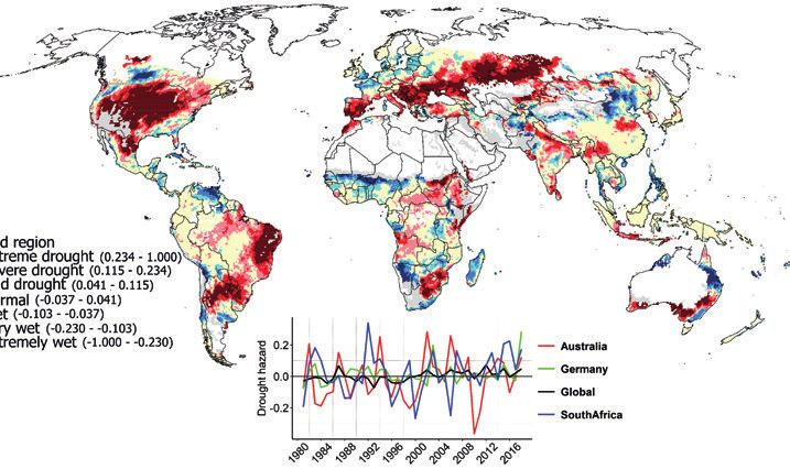
Making GRoW more than the sum of its parts:
The GRoW cross-cutting topics

While the twelve GRoW research projects cover very diverse            •   Irrigated agriculture: This group focussed on legal frame-
topics, a number of thematic and methodological commonalities             works and the potential of social innovations and digitalisa-
exist. In order to harness synergies and ensure that knowledge is         tion in the agricultural sector.
shared across the individual projects, GRoW partners jointly          •   Measuring governance: This group facilitated inter-project
worked on a series of cross-cutting topics over the past 3 years.         exchange on operationalising governance and defining
                                                                          governance indicators for measurement purposes.
Under the direction of the steering committee, three main             •   Turning governance research into practice: This group
cross-cutting topics were selected:                                       assessed the link between the macro and micro level and
                                                                          collects aspects of good governance from the projects, since
1. Incentive mechanisms in the context of governance                      general principles of governance do not always fit the water
2. SDGs (Sustainable Development Goals): Hitting the targets              sector.
3. Water footprint
                                                                      All three subtopics have been explored, each with different GRoW
GRoW partners eager to engage with fellow researchers and             projects involved. Activities and outcomes were presented to the
practitioners organised around these three cross-cutting topics.      sub-groups and external guests interested to participate. A
For each topic, a coordinator as well as an advisor from the exter-   number of special aspects, methods and data could be utilized
nal steering committee were selected to direct the work.              within the GRoW community, such as those regarding agricultur-
Supported by GRoWnet, they organised workshops and online             al irrigation in the context of water reuse and measuring govern-
meetings. The outcomes of their joint work were presented in          ance to balance between competing economic, social and
two dedicated sessions at the Stockholm World Water Week in           ecological aspects.
2019 and various briefing papers summarising shared insights
and recommendations. For more details on the cross-cutting            How to turn water governance research into practice was under-
topics, please see the GRoW website: https://bmbf-grow.de/en/         stood as a new and challenging issue. In order to accomplish
grow/grow-cross-cutting-topics                                        ongoing research relevant for water governance, it was decided
                                                                      to analyse and assess reasons and drivers of failures of water
                                                                      services on the local level, and to digest the outcomes in a brief
Incentive mechanisms in the context of governance                     paper. A first draft of this paper, the Thesis Paper on “Seven Sins
                                                                      Against Local Water Management” was presented to the GRoW
   Coordinators:                                                      steering committee on 7 November 2019. Following a lively
   Prof. Dr. mult. Rudolph (IEEM gGmbH – University                   discussion, the recommendation from the committee was to
   Witten/Herdecke),                                                  continue this work and further verify and reconcile important
   Alexander Grieb (formerly KfW),                                    details, keeping the format of a brief, compiled paper.
   Barbara Gerhager (GIZ)

A number of the GRoW joint research projects are working on
incentive mechanisms (e.g. economic, legal and reputational) to
                                                                          At the GRoW final conference, Prof. Rudolph will pres-
encourage better water resources management. However, much
                                                                          ent a working paper entitled “Good Water Govern-
like the effectiveness of new technologies and processes, the
                                                                          ance: Seven sins against local water management”.
impact of these tools depends heavily on the political and social
frameworks in the target regions. At the first meeting of the             The laymans version of this paper is available for
cross-cutting topic, participants therefore decided to work on the        download at the GRoW website: www.bmbf-grow.de/
link between the macro and micro level of water governance,               recommendations and at the GRoWnet booth on the
which implies scaling down the focus to, for instance, the level of       virtual marketplace.
water utilities in order to achieve SDG 6. In addition, three
sub-working groups were defined:

                                                                                                                                            7
SDGs: Hitting the targets                                            plans and their effects on SDG interactions. The second one, led
                                                                         by Dr Anna Smetanova (TU Berlin), dealt with “Indicators, data
       Coordinators:                                                     and models”, aiming at collecting examples from GRoW on how
       Prof. Dr. Claudia Pahl-Wostl (Osnabrück University),              global SDG 6 monitoring can be complemented to provide
       Dr. Ursula Eid                                                    insights for more sustainable water resources management.

    Working towards achieving the SDGs in general, and SDG 6 in          Currently, both groups within the cross-cutting topic are working
    particular, is a key objective of all GRoW research projects. They   on summarizing the specific outputs to disseminate the final
    develop and test innovative approaches that can help achieving       findings.
    the goals and devise new concepts and key figures for their
    progress evaluation. The cross-cutting topic addresses issues        The group “conflicting targets and synergies” has developed a
    related to the achievement of SDG 6, including leveraging syner-     cooperative assessment procedure to seize synergies and avoid
    gies and minimising trade-offs with other SDGs. In doing so, the     trade-offs between SDG 6 and other SDGs for improved decision
    GRoW researchers created a useful network for strengthening          making in planning processes. Four projects within the GRoW
    and effectively demonstrating the ways in which the individual       funding measure were selected to test the practicability of the
    projects and the overall GRoW funding measure contribute to the      proposed assessment procedure. The assessment procedure is
    achievement of the SDGs.                                             designed based on the idea of integrating different types of
                                                                         knowledge in order to increase the scientific validity, policy rele-
    The working group published a joint GRoW position paper high-        vance and social robustness of decision-making. It aims at mini-
    lighting what the GRoW projects see as key challenges and possi-     mizing conflicts and seizing synergies through context-specific
    ble contributions in the process of achieving SDG 6. This paper      assessment by incorporating different stakeholder groups with
    was channelled into the political process of SDG 6 monitoring        potentially differing perceptions of the conflicts at stake. At SIWI
    and has received positive feedback from a number of institutions     World Water Week 2019, the cross-cutting topic presented key
    in the context of the UN High-Level Political Forum on Sustaina-     insights and recommendations for assessing and addressing SDG
    ble Development in June 2018.                                        trade-offs and synergies to an international audience of different
                                                                         stakeholders from the water sector. Based on this collaborative
    Two sub-groups were created to work on specific aspects of this      work, the group is currently finalizing a manuscript for publica-
    cross-cutting topics: The first one, led by Dr Frank-Andreas Weber   tion in the peer-reviewed journal Sustainability.
    (FiW e.V), addressed “Conflicting targets and synergies between
    different SDG goals”, with the aim of developing a new assess-
    ment procedure for evaluating projects and/or different policy

                                                                                      Figure 1: Proposed Assessment Procedure (© FiW e.V., Aachen).

8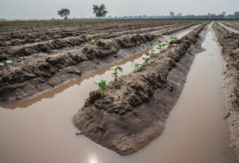
At SIWI World Water Week 2019, GRoW organised the event
                                                                                “Supporting SDG 6 by advancing the water footprint tool” to pres-
                                                                                ent results of the work within this cross-cutting topics. GRoW
                                                                                researchers highlighted that the water footprint approaches
                                                                                developed in their projects are directly relevant to decision-mak-
                                                                                ing processes of the private and public sectors, either to reduce
                                                                                the water footprint at organisational level in supply chains, or to
                                                                                take more sustainable management and policy decisions on a
                                                                                regional level.

                                                                                Based on the findings of the seven GRoW research projects work-
                                                                                ing on the water footprint concept and the discussions within a
                                                                                cross-cutting working group, we recommend to:

                                                                                1. Take a holistic perspective on the water footprint: In order to
                                                                                   make meaningful use of the water footprint concept as a
                                                                                   steering instrument to guide decision making at various
                                                                                   levels, the impacts of water use need to be assessed in addi-
                                                                                   tion to liters of water consumed and polluted by applying
                                                                                   recently developed methods.

 Figure 2: Example for selected interlinkages between SDG 6 and other SDGs      2. Make use of the water footprint to identify where investment
                                                        (© FiW e.V., Aachen).      in more sustainable water use is most efficient. For private
                                                                                   companies as well as for governments, it might be environ-
                                                                                   mentally more beneficial and often economically more effi-
    A presentation on “New approaches towards assessing                            cient to invest in water use efficiency measures at suppliers or
                                                                                   in exporting countries which face high water stress rather
    trade-offs and synergies between SDG 6 and other
                                                                                   than focusing on production-site or domestic measures only.
    SDGs” and a draft policy brief on “Innovative indicators
    and monitoring concepts to support achieving SDG 6
                                                                                3. Analyse virtual water flows and resulting impacts in order to
    in an integrated manner” are available for download on                         identify hotspots, for instance associated with European
    the GRoW website: https://bmbf-grow.de/en/grow-                                imports, and develop specific policy measures mitigating
    cross-cutting-topics/sdg-hitting-the-targets and at the                        local water stress in the exporting countries. These could
    GRoWnet booth on the virtual marketplace.                                      include providing incentives for more efficient water usage or
                                                                                   steering specific technical development assistance. Policy
                                                                                   measures based on virtual water trade analysis should consid-
                                                                                   er local circumstances to prevent negative social and econom-
Water footprint                                                                    ic trade-offs, such as, reduced income or unemployment.

   Coordinators:
   Dr. Markus Berger (TU Berlin),                                                   To collect and disseminate their recommendations on how
   Dr. Falk Schmidt (IASS Potsdam)                                                  to enhance and effectively apply the water footprint
                                                                                    concept, participants in this cross-cutting topic published
Several of the GRoW research projects investigate how consump-
                                                                                    the GRoW policy brief “Advancing the Water Footprint into
tion and production is linked to and affects water resources in
                                                                                    an instrument to support achieving the SDGs”. The policy
other parts of the world. They develop methods for measuring
                                                                                    brief is available for download at the GRoW website: www.
water footprints in order to identify areas where water is being
used inefficiently, and implement practical measures to reduce                      bmbf-grow.de/recommendations and at the GRoWnet
the respective water footprint.                                                     booth on the virtual marketplace.

                                                                                    Moreover, the cross-cutting group developed a “water
Within the cross-cutting topic, GRoW projects discussed three
                                                                                    footprint toolbox” (https://wf-tools.see.tu-berlin.de/wf-tools/
major issues: First, the potential of the water footprint as a tool to
support mitigation efforts; Second, the relation between water                      waterfootprint-toolbox/). Depending on the question stake-
footprints and the assessment of economic and social impacts;                       holders might have with regard to water footprinting – the
And third, how aspects of water quality (including groundwater)                     app suggests a corresponding database, impact assess-
can be more effectively included in water footprint assessments.                    ment method, standard or online tool.

                                                                                                                                                      9
GRoW Case study regions
     • GLOBAL WATER
       RESOURCES
       ViWA
       Danube River Basin (Romania, Hungary,
       Serbia, Bulgaria, Slovakia, Slovenia,
       Austria, Germany)
       Zambesi River Basin (Zambia,
       Zimbabwe, Mozambique, Namibia)

       GlobeDrought
       Republic of South Africa, Zimbabwe,
       USA

       SaWaM
       Iran, Brazil, Sudan, Ethiopia, Ecuador,
       Peru, West Africa

       MuDak-WRM
       Germany, Brazil

       MedWater
       France, Italy, Israel, Palestinian territories

     • GLOBAL WATER
       DEMAND
       WELLE
       Belgium, Germany, South Africa, USA

       InoCottonGRoW
       Pakistan, Turkey

       WANDEL
       Germany, Morocco, Brazil

     • GOOD GOVERNANCE IN
       THE WATER SECTOR
       STEER
       Emscher (Germany)
       Weser-Ems (Germany)
       Guadalquivir (Spain)
       Kharaa-Yeroo (Mongolia)
       uMngeni (South Africa)
       Zayandeh-Rud (Iran)

       Trust
       Peru

       iWaGSS
       Lower Olifants Catchment (South Africa)
       Mara River Basin (Kenya)
                                                        In addition to local case studies, global computer models were employed by the
       go-CAM                                           following projects: ViWA, SaWaM, GlobeDrought, WANDEL
       North-Eastern Brazil, North-Western
       Germany, Turkey, South Africa

10
(Stand: Oktober 2020)
11GRoW – WATER AS A GLOBAL RESOURCE
ViWA – Virtual Water Values
PROJECT GOALS
98% of global water use is allocated to producing food and
biomaterials through green (rainfall) and blue (irrigation) water.
Agricultural water use efficiency (AWUE) and sustainability
have to increase globally to meet water- and food-related
Sustainable Development Goals (SDGs). Global data on the effi-
ciency and sustainability of the virtual water contained in agricul-
tural goods traded on global markets is not available. ViWA aims
at 1) developing ways to monitor AWUE with high resolution and
accuracy; 2) identifying, through simulation, global hot-spots of
Coordination inefficient and unsustainable agricultural water use and 3) analys-
Prof. Dr. Wolfram Mauser, LMU Munich ing scenario alternatives for more sustainable agricultural water
use, as well as their economic and environmental trade-offs. ViWA
acts globally and regionally in the two pilot watersheds Danube
German partners
and Zambesi. The results of ViWA aim at supporting global and
• Kiel Institute for the World Economy (IFW) regional organizations and companies in improving the sustaina-
• Leibniz University Hannover bility of their water related decisions.
• Helmholtz-Centre for Environmental Research UFZ
Leipzig
• Leibniz Supercomputing Centre of the Bavari-
an Academy of Sciences and Humanities (LRZ), KEY RESULTS
Garching
• GERICS Climate Service Center Germany, Hamburg • An innovative AWUE monitoring system based on incorpo-
• VISTA GmbH, Munich rating Sentinel satellite observations into the high-resolution,
• Georg Hipp OHG (associated partner) coupled crop- and water simulations model PROMET was
• BayWa AG (associated partner) developed. The system monitors AWUE, water shortage, irriga-
• GIZ (associated partner) tion and yield expectations for 16 crops with a resolution of
1km/1d on a global scale. PROMET was run on the LRZ high-
International Partners performance-computer SuperMUC with global meteo-drivers
• International Commission for the Protection of the (e.g. ERA5 and CORDEX) and data from >15000 Sentinel-2
Danube river (ICPDR) images to simulate the agricultural water cycle and actual
• The Romanian Academy crop growth globally and in the pilot regions.
• World Wide Fund For Nature (WWF) • Annually varying global hot- and cold spots of AWUE and
• European Space Agency (ESA) yield were identified. The monitoring system shows hot-spots
of low AWUE e.g. in the East and South of sub-Saharan Africa
(see Figure 1).
i FURTHER INFORMATION
Project website: https://viwa.geographie-
muenchen.de/
Figure 1: Global Water Use Efficiency of Maize (2015-2017) (Source: ViWA).
12• AWUE and fertilizer use (rainfed, irrigated) was incorporated expense of a serious reduction in average summer discharge
into the Computable General Equilibrium model ART for glob- in the Lower Danube and its tributaries. Economically, irrigat-
al trade. Trade-offs of scenarios of water decision alterna- ed maize yield gains compensate losses in hydropower by a
tives were analysed. The scenarios depict the consequences of factor of more than 20.
regulations, such as developing irrigation or intensifying agri- • Tools to analyse the ecological impacts of water use alter-
culture. Generally, intensifying agriculture leads to a reduction natives regarding WFE nexus water conflicts were developed
of virtual water trade volume. and used in the Danube basin. Locations of wetlands and
• Regionally, PROMET (resolution: 1km, 1h) was used as a tool to groundwater flows were combined with the consequences of
simulate coupled water-food-energy (WFE) nexus water maize irrigation scenarios (see Figure 2).
conflicts in transboundary watersheds, such as water use for • The global effects of regional climate variability induced
energy production vs. irrigation. The introduction of large- water stress on regional agricultural yields, such as the one
scale irrigation in the Danube basin (800 000 km²) was used as caused by El Niño in 2015, were simulated using high-resolu-
an example for such an evolving nexus conflict. The effect of tion meteo drivers. CORDEX meteo drivers show, that large-
expanding irrigation on maize fields on river flows shows that scale meteorological anomalies like El Niño have pronounced
maize yields can be doubled and AWEU increases at the impacts on regional agricultural water security and yields.
Figure 2: Assessment of July minimum flow changes through full maize irrigation from surface waters and selected monthly discharges with and w/o
maize irrigation (blue line = no irrigation, red line = full irrigation of maize, blackline = withdrawal) (Source: ViWA).
OUTLOOK AND FUTURE APPLICATIONS
ViWA demonstrated how new big-environmental-data from global impacts and trade-offs of water-decisions and in resolving
EU’s Sentinel-2 environmental satellites and global meteo-simu- WFE nexus conflicts.
lations (e.g. GERICS, ERA5) inform coupled hydrological/
agro-physiological/groundwater process models. The result is a ViWA’s results represent one first step towards fully integrating
powerful global-to-local toolbox to monitor and analyse regional global big-environmental-data and simulations into transbound-
water conflicts in the context of the WFE nexus. Hot-spots and ary management of natural resources on all scales, from local to
global teleconnections (e.g. El Niño) become visible. This global, with the purpose to ensure sustainable water, food and
improves downstream economic models and ecological assess- energy supply.
ment tools. They support stakeholders in assessing the local-to-
13GRoW – WATER AS A GLOBAL RESOURCE
GlobeDrought – A global-scale tool
for characterizing droughts and
quantifying their impact on water
resources
PROJECT GOALS
The main goal of the project is to provide a risk analysis of adverse
drought impacts for agricultural systems and public water supply.
It produces a spatially explicit description of drought risks at glob-
al and national scales. The results are presented in a web-based
drought information system, which consists of the components
(i) long-term drought risk, (ii) drought status, and (iii) an experi-
mental early warning system. The global component of the
system allows to consistently comparing drought risk for different
countries and the drought status for different periods. Assess-
Coordination ments that are much more detailed are provided for the case
Prof. Dr. Stefan Siebert, University of Göttingen study region Southern Africa (incl. South Africa and Zimbabwe) to
support national drought risk management. In contrast to other
operational early warning systems, data from process-based
German partners models is combined with data from remote sensing to make use
• University of Bonn of the advantages of both data sources in the analysis of drought
• Goethe University Frankfurt hazard and drought status.
• United Nations University
• Remote Sensing Solutions GmbH
• Deutsche Welthungerhilfe e.V.
KEY RESULTS
International Partners
Advanced methods for integrated drought risk
• Joint Research Centre of the European Commis-
analysis developed
sion (JRC), Ispra, Italy
A comprehensive review of the literature on drought risk assess-
• World Wildlife Fund (WWF)
ments revealed conceptual and methodological deficiencies, and
• University of Free State, Republic of South Africa
highlighted the need for impact-specific assessments when
• South African Weather Service
analysing drought risks. Based on stakeholder consultations
• National Disaster Management Centre, Republic
during the first project workshop, it was decided to focus on
of South Africa
drought risks for irrigated and rainfed agricultural systems, and for
• University of Zimbabwe
water supply. GlobeDrought developed novel approaches for
assessing the drivers and spatial patterns of drought risk for agri-
cultural systems and public water in an integrated manner at the
global scale and applied it to South Africa and Zimbabwe at the
sub-national scale.
Improved resolution and extent in drought hazard
analysis by combining process-based models and
remote sensing
Several indicators derived from remote optical sensors were
successfully applied to study drought hazard at high spatial reso-
i lution. These indicators showed high correlation to indicators
FURTHER INFORMATION derived from process based hydrological- or crop water models.
Assimilation of GRACE gravity data in the global hydrological
Project website: https://grow-globedrought.net/
model WaterGAP resulted in an improved representation of long-
term trends in water storage changes, e.g. by non-sustainable
14groundwater use. Combination of remote sensing and process- Various channels used for knowledge
based models allowed mapping drought hazard for long periods, dissemination and transfer
at high spatial and temporal resolution and to project future 15 articles in international scientific journals have been published
changes in drought hazard. describing the methods developed in the project and over 10
additional studies are in progress. The results of the global and
Vulnerability to drought systematically analysed regional assessments are presented in a web-based drought
using a participatory approach information system1. Joint publications with key stakeholders
Based on expert and stakeholder consultation, appropriate facilitated the use of our data and products, for example in the
drought vulnerability indicators and their weighting were identi- Global Drought Monitor or by politicians and citizens. Twelve
fied for irrigated and rainfed agricultural systems in Zimbabwe, digital lectures and webinars have attracted the attention of
South Africa and at global scale. They were then combined with several hundred participants and are available on the eLearning
hazard and exposure to study drought risk. For the first time, Platform of the project website.
spatiotemporal changes in vulnerability of agricultural systems to
drought since 1990 are studied and compared to variability in 1 Available at http://map3d.remote-sensing-solutions.de/globedrought/
drought hazard. GlobeDroughtPortal
Figure 2: Vulnerability to drought of rainfed ag-
ricultural systems in South Africa at the munici-
pality level (Source: Meza et al., unpublished).
Figure 1: Drought hazard for rainfed agricultural systems Figure 3: Correlation between modelled and remotely
in year 2012 (top) and in period 1981-2018 for South Africa, sensed ratio between actual and potential evapotran-
Germany, Australia and at global scale (bottom). spiration for rainfed crops in South Africa in period
(Source: Eyshi Rezaei et al., unpublished) 2001-2018 (Source: Eyshi Rezaei et al., unpublished).
OUTLOOK AND FUTURE APPLICATIONS
We learned that appropriate indicators used for drought risk drought hazard cannot be completely controlled, more efforts
analyses differ depending on the specific drought impact that is are needed to reduce the vulnerability of exposed systems to
studied. Consequently, data and methods used for irrigated drought. By providing insights not only into spatial hotspots (i.e.
agriculture vary considerably from those used for rainfed regions of particularly high drought risk), but also on the under-
systems. Methods and tools for monitoring and forecasting of lying drivers of risk, GlobeDrought offers important entry points
drought hazard at global and regional scale have been for strengthening resilience. More research is needed to investi-
developed, but the applicability for specific purposes depends gate which interventions reduce vulnerabilities most effectively,
a lot on the availability and quality of remote sensing and clima- and whether these strategies can be generalized across space
te input data. More research is required to test the proficiency of and time.
seasonal weather forecasts for drought projections. While
15GRoW – WATER AS A GLOBAL RESOURCE
SaWaM – Seasonal Water Resources
Management: Regionalized Global Data
and Transfer to Practice
PROJECT GOALS
Increasing frequencies of droughts and heat extremes, as well as
increasing precipitation variabilities in semi-arid regions fuel
conflicts over water use and call for mitigation of impacts of
climate change (Figure 1). Proactive and sustainable water ma-
nagement is required, which can benefit from hydro-meteoro-
logical seasonal forecasts and high-resolution, near-real-time
measurements. For comprehensive water management, all
sources and sinks of freshwater resources need to be known,
including not only the full hydrology, but also ecosystems regard-
Coordination ing the food-energy-water nexus. With semi-arid regions being
Prof. Dr. Harald Kunstmann, Karlsruhe Institute of Technol- hot spots of erosion, further sediment input, transport and depo-
ogy, Institute for Meteorology and Climate Research (KIT/ sition are key for sustainable reservoir operations. The SaWaM
IMK-IFU)
project addresses the question whether regional water manage-
German partners ment and in particular dam operation in semi-arid regions can be
• University of Potsdam improved by the use of global, publicly available information with
• University of Stuttgart
• Philipps University of Marburg a focus on near-real-time and seasonal timescales. With the provi-
• Helmholtz-Centre for Environmental Research Leipzig sion of a tailor-made information system of supportive regional-
(UFZ) ized information for each of our semi-arid study basins in Iran
• Helmholtz Centre Potsdam GFZ German Research Centre
for Geosciences (Karun), Brazil (Sao Francisco), Ethiopia-Sudan (Tekeze-Atbara and
• TU Berlin Blue Nile), and Ecuador-Peru (Catamayo-Chira), we target the
• Tractebel Engineering GmbH local water managers and emphasize the use of near-real-time
• Gesellschaft für Angewandte Fernerkundung
GAF AG information and seasonal forecasts in hydrological decision-
International Partners
making.
• The Khuzestan Water & Power Authority KWPA, Iran
• Fundação Cearense de Meteorologia e Recursos Hídricos
(Foundation Cearense for Meteorology
and Water Resources, FUNCEME), Brazil
• Agencia Nacional de Aguas (National Water Agency,
ANA), Brazil
• Ministry of Water Resources & Electricity, Dams
Implementation Unit (DIU), Sudan
• Sudanese Meteorological Authority (SMA), Sudan
• Prefectura Loja, Ecuador
• Universidad Técnica Particular de Loja (UTPL), Ecuador
• Gobierno Regional Piura, Peru
• West African Science Service Centre on Climate Change
and Adapted Land Use (WASCAL)
Figure 1: Increasing frequencies of very warm and drought months per year
i in the regions of São Francisco (Northeast Brazil), Niger, Volta (West Africa),
Tekeze-Atbara, Blue Nile (Northeast Africa) and Karun (Iran) from 1981-2018
FURTHER INFORMATION evaluated by ERA5 reanalysis data.
Project website: http://grow-sawam.org
16KEY RESULTS Seasonal forecasts provide economic benefit for
regional water management
Publicly available satellite- and global model Switching towards seasonal-forecast-based early actions
information for transboundary water management proved to save expenses and support climate proofing. If
The main variables necessary for regional water management perfect seasonal forecasts and optimal action are defined as
can be derived from global, publicly available, in-situ, model- 100% economic savings, the SaWaM seasonal-forecast-based
based and remote-sensing information. However, the develop- actions for droughts could achieve 70% of maximum possible
ment of these approaches still requires local knowledge and economic savings. For all semi-arid study regions, including
quality-controlled local data. Global information can serve as West Africa, high potential economic values do not only occur
a valuable complement where there are gaps in local informa- for short forecast horizons, but up to seven months ahead. The
tion. assessment of economic value allows stakeholders to understand
the forecast skill from an economic perspective, offering a broad-
Development of a regional operational hydro- er range of possible applications of seasonal forecasts.
meteorological seasonal forecasting system
A fully-integrated model chain produces seasonal forecasts on Multi-aspect drought assessment by monitoring,
regional hydro-meteorology at 0.1° horizontal resolution and remote sensing and forecasting
with forecast horizons up to seven months ahead (Figure 2). The comprehensive, multi-disciplinary approach of SaWaM
Comprehensive forecasts were achieved via bias correction and allows for a multi-aspect drought assessment, bringing together
regionalization of publicly available global seasonal forecasts. The monitoring, remote sensing and forecasting. Droughts are
representation of uncertainties due to ensemble simulations and studied not only from a hydro-meteorological point of view, but
the needs of specific users were elaborated through active also with respect to their implication on ecosystems. Water
stakeholder integration, including intensive interaction in shortages did not necessarily entail negative ecosystem anoma-
on-site workshops and revision of the provided online-tool. lies when freshwater resources remaining available were used for
irrigation.
Erosion hot spot analysis tool helps to prevent
reservoir sedimentation
A newly developed hot spot analysis tool identified erosion hot
spot areas that particularly contribute to the sedimentation of
water reservoirs, thereby impairing water management. The tool
could provide decision support on preventative land
management for areas where improved land management has
the largest impacts on reservoir sedimentation.
OUTLOOK AND FUTURE APPLICATIONS
Comprehensive forecasting months ahead proved to be possible
when applying modern post-processing of publicly available
global seasonal forecasts. Seasonal-forecast-based early action
provides clear economic benefits, stressing the advantage and
necessity of considering seasonal forecasts in hydrological deci-
sion-making. On-site workshops in our study regions were crucial
for our success, particularly for accessing local data and creating
profound impact. Building trust over years of close cooperation is
required to overcome initial skepticism and is key to effectively
transfer developed methods and information into practice.
User-friendly visualization of probabilistic forecasts in coopera-
Figure 2: Forecast of the most likely tercile (top) and extreme (bottom) precip- tion with companies and stakeholders requires long iterations,
itation category issued on 01.07.2020 for July, August, and September 2020 which are still on-going. Future application of our derived prod-
over the transboundary Tekeze-Atbara and Blue Nile basins. Our forecasts ucts is ensured by the operationalization of the hydro-meteoro-
predicted high probabilities of above normal and even extreme wet condi-
logical model chain of seasonal forecasts and selected near-real-
tions across large parts of Ethiopia. During this three-month period, heavy
rainfall particularly in Ethiopia led to record water levels of the Blue Nile, time information, as well as their provision in the SaWaM
which then caused severe flooding across 16 Sudanese states and affected online-tool. The implementation and further development of
more than 3,000,000 people. methods is now planned for Europe and Germany.
17GRoW – WATER AS A GLOBAL RESOURCE
MuDak-WRM – Multidisciplinary Data
Acquisition as Key for a Globally
Applicable Water Resource Management
PROJECT GOALS
Under rising pressure on land use in catchments and water quali-
ty deterioration in rivers, eutrophication and loss of good water
quality threaten many reservoirs around the world. In order to
implement successful measures to protect water quality, the
precise assessment of the actual situation as well as predictions
of medium to long-term changes are an important basis for deci-
sions. Besides the general availability of numerous models for
terrestrial and aquatic ecosystems, most models are complex and
data demanding and the adaptation to specific questions is often
Coordination limited.
PD Stephan Fuchs, Karlsruhe Institute of Technology (KIT),
Institute of Water and River Basin Management, Depart- The core aim of MuDak-WRM is to investigate to which extent the
ment of Aquatic Environmental Engineering (IWG-SWW)
ecological situation within a reservoir (trophic status) and in the
German partners catchment of the reservoir can be represented and modelled
• KIT IWG-WK, Institute of Water and River Basin based on a simplified set of parameters. In order to reduce the
Management, Department of Water Resources
Management effort and costs of monitoring, the MuDak-WRM team set out to
• KIT IPF, Institute of Photogrammetry and Remote increase the understanding of catchment-lake related and inter-
Sensing nal lake processes, which are relevant for water quality. The key
• University Koblenz Landau, Institute of Environmental
Physics aspect is to identify all relevant parameters influencing the long-
• HYDRON GmbH, Karlsruhe term behavior of the reservoir. Based on the obtained under-
• 52°North - Initiative for Geospatial Open Source standing, we developed a minimum monitoring concept for the
Software GmbH, Münster
• EFTAS GmbH, Münster specific compartments of the reservoir (catchment, river, water
• Wupperverband, Wuppertal column, sediment). The complexity and data demand of applied
• TriOS Mess- und Datentechnik GmbH, Rastede models (nutrient and sediment input, water balance, water quali-
International Partners ty, hydrodynamics) was reduced to allow for an easier and global
• Paraná State Sanitation Company (Companhia de application.
Saneamento do Paraná, SANEPAR), Curitiba
• Federal University of Paraná (Universidade Federal do
Paraná, UFPR), Curitiba The MuDak-WRM project addresses reservoir operators, authori-
• University Positivo, Curitiba ties (environmental ministries and agencies), reservoir planning/
• Paraná Water Resources Institute (Águas do Paraná),
Curitiba design companies, companies working with environmental
• Paraná Institute of Rural Development and Assistance monitoring and modelling, and other researchers.
(Instituto Paranaense de assistência técnica e extensão
rural, (EMATER), Curitiba
• Simepar (Paraná Meteorological Institute), Curitiba
• Lactec Research Institutes, Curitiba
• Instituto Ambiental do Paraná (IAP)
• Agência Nacional de Águas (ANA)
• The Nature Conservancy Brasil (TNC)
i
FURTHER INFORMATION Figure 1: Sediment front in the inflow region of Passaúna reservoir
(© T. Bleninger).
Project website: http://www.mudak-wrm.kit.edu/
18KEY RESULTS • Integration, visualization and storage of variable data types as
real-time water quality data and raster-based catchment data
• On the catchment site, the MuDak-WRM project developed in a Sensor Web application (Figure 3).
automatized remote sensing approaches to retrieve land-
cover and urban soil sealing on a yearly basis, the Leaf Area The findings from the MuDak-WRM project with its high-resolu-
Index and surface albedo with monthly resolution. Within the tion investigation of Passaúna reservoir lead to the conclusion
reservoir, Chlorophyll-a and total suspended matter were that simplified management patterns cannot be transferred
obtained every five days and water temperature every 16 to other reservoirs. The necessity to create a one-time robust
days. data base including precise bathymetry, water balance, actual
• A simplified water balance model with increased input data nutrient stock (water and sediment) and a basic understanding of
from remote sensing and reduced spatial resolution was specific lake processes (e.g. P-fixation by iron and carbonate or
successfully applied to increase global applicability. influence of pre-dam structures on stratification and transport
• A low-complexity sediment and phosphorous emission dynamics) needs to be emphasized. In order to keep the operator
model was set up for one German and one Brazilian reservoir. in control of the long-term development of the water body, a
The model was validated using the reservoirs as long-term minimum water monitoring at the inflows and at one location
accumulation points. inside the reservoir needs to be implemented. For larger reser-
• A multiple-method approach leads to a high-resolution voirs, this monitoring can be supplemented by continuous
sediment investigation of the accumulated sediment and supervision of lake development (turbidity, Chl-a, Temp.) using
phosphorous mass, creating the basis for a lifetime assess- satellite imagery.
ment, phosphorous release model and hydrodynamic sedi-
ment distribution modelling (Figure 2). In our case, modelled nutrient and sediment input underesti-
mated the flux by 50 %, while even long-term in-river sampling
was prone to massive underestimation, in this case by 7 to 14
times. Episodic flood events seem to have a severe effect on the
development of a reservoir; however, they are hard to catch with
regular monitoring.
Consequently, an assessment of in-reservoir sediment mass
seems to be the most robust approach for long-term accumula-
tion of sediment and phosphorous. It is the best option to adapt
and validate low-complexity models for the operator.
Figure 2: Siltation inside the reservoir shows importance of density
currents by the difference of settling and accumulated sediment.
(Source: S. Hilgert, MuDak-WRM).
OUTLOOK AND FUTURE
APPLICATIONS
• For most reservoirs, the first full
assessment of the actual state is
the essential basis for all future
management practices.
• Internal storage of nutrients may
threaten good water quality
under changing conditions;
therefore, it plays a major role for
lake management.
• Pre-dams seem to be a promising
protection measure for lakes with
deteriorating quality or increas-
ing pressure from the catchment.
• Consistent storage of monitoring
data and availability via online
applications are essential for the
Figure 3: Visualization of sampling locations and water quality assessment of the actual and
parameters in the web client (Source: MuDak-WRM). future water status.
19GRoW – WATER AS A GLOBAL RESOURCE
MedWater – Sustainable manage-
ment of politically and economically
relevant water resources in highly
dynamic carbonate aquifers of the
Mediterranean
PROJECT GOALS
Circa 10% of the world’s population relies on groundwater
resources from karst aquifers. Due to their complex geological
structure, prediction of groundwater flow is extremely difficult,
which complicates their management. The Intergovernmental
Panel on Climate Change estimates that precipitation in the
Mediterranean region, where karst aquifers are particularly
common, will decrease by up to 27% until 2100. In addition, the
Mediterranean will experience a population growth of 100 million
Coordination until 2030. To adapt to these challenges, MedWater develops new
Prof. Dr. Irina Engelhardt, TU Berlin tools and strategies for better management of groundwater
resources from karst aquifers. The project focusses on the Western
Mountain Aquifer (WMA) in Israel and the Palestinian Territories.
German partners As a key result, a web-based decision support system is devel-
• TU Berlin oped in close cooperation with decision-makers. Results are
• University of Göttingen transferred to aquifers with similar climates and flow characteris-
• University of Bayreuth tics in Italy and France.
• University of Würzburg
• VisDat GmbH
• BAH Berlin
KEY RESULTS
International Partners
MedWater investigated various methods of calculating the spatial
• Bureau de Recherches Géologiques et Minières
and temporal distribution of groundwater recharge. With the Soil
(FR)
& Water Assessment Tool (SWAT), we determined a long-term
• Montpellier Méditerranée Métropole (FR)
• Università degli Studi di Napoli Frederico II (IT)
• Centro Euro-Mediterraneo sui Cambiamenti
Climatici (IT)
• Israel Hydrological Service (IL)
• Mekorot Water Company Ltd. (IL)
• Ben-Gurion University of the Negev (IL)
• Hebrew University of Jerusalem (IL)
• Ariel University / Eastern R&D Center (IL)
• Palestinian Water Authority (PS)
i
FURTHER INFORMATION Figure 1: A high-resolution climate model until 2070 predicts warmer winters,
Project website: http://www.grow-medwater.de increasing fall and winter evaporation. Combined with less precipitation, this
phenomenon will significantly decrease groundwater recharge of the WMA
(Source: MedWater).
20average recharge for the WMA of 145 mm/a
(1990-2018) (Figure 2a). The recharge zone plays
an important role for ecosystem services and
provides 20% of river flow regulation, 70% of
flood regulation, 80% of soil erosion regulation,
and 75% of water quality regulation. Shifts in
climate will affect both groundwater resources
and ecosystem services. High-resolution climate
projections show a seasonal increase of temper-
ature by 2.13°C until 2070, while precipitation
will decrease by up to 59% in the fall (Figure 1).
Due to shifts in climate, mean annual ground-
water recharge will decrease by 18% (1980-
2000 vs. 2050-2070).
Identification of the karst conduit network was
enabled using the Stochastic Karst Simulator
(Borghi et al., 2012) (Figure 2b), which computes
karst structures based on paleoclimatic recon-
structions of the Mediterranean Sea level and
climate over the last 6 million years. Simulations
show that the geometry of a karst network is
highly controlled by the position of past Figure 2a, b, c: Spatial and temporal recharge distribution, probability of the
karst springs. This “soft” information on karst development location of highly permeable conduits and simulated drawdown
allows for the generation of a sound hydraulic parameter field. (2020 – 2040) of the groundwater table (Source: MedWater).
With a multi-continuum model (HydroGeoSphere), we simulated changes in groundwater stress results in a global vulnerability
the vadose zone dynamics together with the groundwater flow map of 356 karst aquifers. We even found that 52 carbonate
system (Figure 2c). Scenario analyses explored the impact of aquifers will have moved to more extreme arid climates (e.g.,
pumping rate adaption and indicate a rapid 2 m groundwater steppes or deserts) by 2100.
level decline over the next 5 years followed by a further drop
of 3 m by 2040 in a resource-intensive scenario.
Agricultural food production is by far the highest water user in OUTLOOK AND FUTURE
Israel. 1,806 MCM of virtual blue water (BW) was used for Isra- APPLICATIONS
el’s food production in 2005. Of those, 11% comprised BW for
exports. For local BW consumption, wheat, apples, olives, and MedWater models allow for quantification of available water
peaches are the highest water users, while potatoes, dates, resources at short, i.e. daily time scale, and for predictions used in
grapes, and olives are most water-intensive with respect to long-term management concepts. By coupling numerical model-
exports. ling with user-friendly tools, we provide a solid knowledge base
for decision-making. An adapted management of karst aquifers
The Decision Support System (DSS) includes results of the makes use of their different storage system types, i.e. store flood
groundwater model, recharge estimates, climate projections, and water following intensive recharge events, which can be abstract-
scenario analyses. Employing analytical functions, the DSS simu- ed later during droughts. This requires differential pumping and
lates the aquifer response to changes of parameter sets or pump- injection schemes and a proper real-time operation of the stor-
ing rates. A multi-objective optimization (MOO) framework age system. Especially vadose zones of karst systems are an
allows water users to test groundwater management strategies: important storage compartment if they extend over hundreds of
Groundwater extraction and water injection wells are optimized meters. Temporal and spatial variation of recharge was not fully
with respect to demands (e.g. agricultural, municipal) and water quantified in MedWater and should be addressed more in detail
sources (e.g. desalination, treated wastewater). in the future. Finally, management of karst aquifers in the
circum-Mediterranean area is impeded by the presence of salt-
On the global scale, we created generalized models for different water bodies. Future research efforts should be placed on the
types of Mediterranean karst aquifers. A Groundwater Stress management of karst water resources surrounded by saline
Index combines information about groundwater recharge, stor- water, employing hydraulic control techniques or engineering
age, and abstraction rates, as well as groundwater-dependent barriers.
ecosystems, among other things. Simulating climate-driven
21GRoW – WATER AS A GLOBAL RESOURCE
WELLE – The Water Footprint of
Organizations: Local Measures in
Global Supply Chains
PROJECT GOALS
Most companies measure and manage water consumption at
their premises only. However, most of a company’s water
consumption typically occurs along global supply chain stages,
such as sourcing of raw materials or generation of electricity, but
also during the use phase of products. The goal of WELLE was to
develop a framework for companies (and organizations in gener-
al) to identify and analyze these hidden water consumption
hotspots and to provide tools to help mitigating them.
Coordination
Prof. Dr. Matthias Finkbeiner, Chair of Sustainable
Engineering, TU Berlin KEY RESULTS
The Organizational Water Footprint (OWF) Practitioners’
German partners Guidance1 provides a framework that is both comprehen-
• German Copper Alliance (Deutsches Kupferinstitut sive and easily applicable for assessing the entire water foot-
Berufsverband e.V.) print of a company. It illustrates the OWF method developed in
• Evonik Nutrition & Care GmbH the project, which follows life cycle thinking and builds up on
• Neoperl GmbH established environmental assessment frameworks, namely the
• Thinkstep AG (now Sphera Solutions, Inc.) Water Footprint (ISO 14046) and Organizational Life Cycle Assess-
• Volkswagen AG ment (ISO 14072). The practitioners’ guidance aims to increase
the accessibility of the OWF method for non-experts and thus to
facilitate its application. While companies are aware of their direct
water consumption at their premises, they usually lack informa-
tion on their indirect water consumption associated to produc-
tion of raw materials or generation of energy. Therefore, a region-
alised inventory database providing water consumption
data and information on resulting local water-scarcity
impacts has been developed for a wide range of raw and inter-
mediate materials, energy supply, transportation and the use and
operation of buildings and offices.
Finally, the OWF method and database were integrated into
a free OWF online tool 2. The WELLE OWF Tool is a free online
application which assists companies in calculating their Organi-
zational Water Footprint. Users can enter the direct water use at
premises as well as indirect upstream activities (e.g. amounts of
purchased materials and energy), indirect downstream activities
(e.g. volumes of water consumed in products’ use phases), and
i supporting activities (e.g. business trips). By linking this informa-
tion to the activity-specific water consumption data provided by
FURTHER INFORMATION the WELLE database, the organization’s water consumption along
Project website: https://welle.see.tu-berlin.de/
1 https://welle.see.tu-berlin.de/owfguide.pdf
2 https://wf-tools.see.tu-berlin.de/wf-tools/owf/
22You can also read