FINAL - Mildura Riverfront Masterplan - Daryl Jackson Pty Ltd Architects KLM Gerner Consulting Group - Mildura Rural City Council
←
→
Page content transcription
If your browser does not render page correctly, please read the page content below
Mildura
 Riverfront
Masterplan
                          March 2005

                        Prepared For:
            Mildura Rural City Council

                                         FINAL

Daryl Jackson Pty Ltd Architects

  KLM Gerner Consulting Group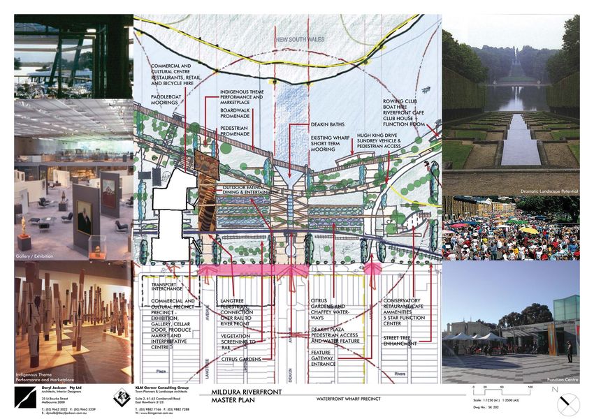
CONTENTS Page
Table of Contents i
The Design Team iii
EXECUTIVE SUMMARY 1
1.0 DESCRIBING THE MILDURA RIVERFRONT MASTERPLAN 3
1.1 USING THE MASTERPLAN 3
2.0 STORYLINE 4
3.0 THE CONTEXT OF MILDURA 5
4.0 EXISTING ASSESSMENT 6
4.1 THE RIVER AND THE CITY 6
4.1.1 Activities and uses 6
4.1.2 Visual Assessment 6
4.1.3 Vehicle Traffic and Parking 7
4.1.4 River Traffic and Mooring 8
4.1.5 Pedestrian and Bicycle Access 8
4.1.6 Landscape Character 8
4.1.7 Sustainability 9
4.1.8 Precinct Issues 10
4.1.9 Land Tenure & Development Controls 11
4.1.10 Supporting Documents 15
5.0 AIMS AND OBJECTIVES 16
5.1 INTEGRATION AND VISUAL CHARACTER 16
5.2 ECONOMIC OBJECTIVES 16
5.3 ENVIRONMENTAL OBJECTIVES 17
5.4 COMMUNITY CONSULTATION 18
5.5 MANAGEMENT OBJECTIVES 18
5.6 OPPORTUNITIES AND CONSTRAINTS 19
5.6.1 Opportunities 19
5.6.2 Constraints 19
6.0 THE VISION 20
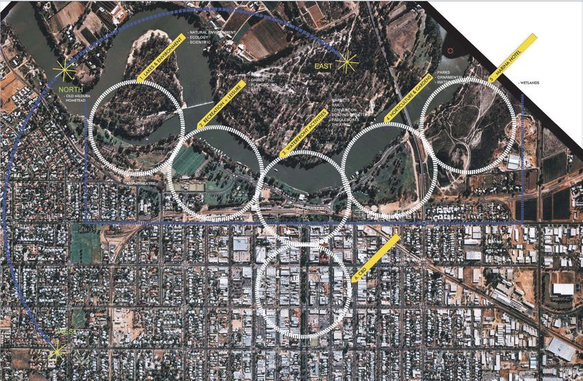
6.1 THE PRECINCTS 22
6.1.1 Mildura Wharf Waterfront 22
6.1.2 Games and Entertainment Precinct 25
6.1.3 The Art and Lock Precinct 26
6.1.4 Chaffey Water Gardens Precinct 27
6.1.5 The Marina Precinct 28
6.2 MASTERPLAN ASSESSMENT 30
6.2.1 Access and Identity 30
6.2.2 Visual and Physical Connections 31
6.2.3 Vehicle Traffic and Parking 32
6.2.4 River Traffic and Mooring 33
6.2.5 Pedestrian and Bicycle Access 34
6.2.6 Landscape Character 35
6.2.7 Land Tenure & Development Controls 37
6.2.8 Environmental Study 39
6.3 URBAN DESIGN GUIDELINES 41
6.3.1 Building Form 41
6.3.2 Streetscape 42
6.3.3 Parking and Vehicle Accessways 43
6.3.4 Landscape 43
6.3.5 Paving 43
6.3.6 Furniture 44
Page: i Mildura Rural City Council
Riverfront Masterplan
Daryl Jackson Pty Ltd Architects
KLM Gerner Consulting Group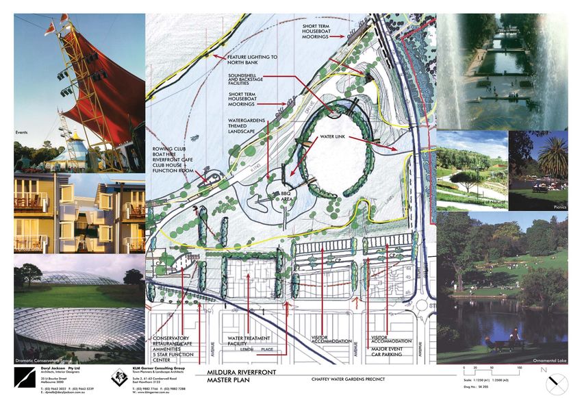
6.3.7   Public Art                                44
           6.3.8   Signage                                   44
6.4        SUSTAINABLE DEVELOPMENT GUIDELINES                45
           6.4.1   Energy                                    45
           6.4.2   Water                                     45
           6.4.3   Materials                                 45
           6.4.4   Indoor Environmental Quality              45
           6.4.5   Construction and Demolition               46
           6.4.6   Transport                                 46
           6.4.7   Social                                    46
7.0        THE BENEFITS                                       47
7.1        ECONOMIC BENEFITS                                 47
7.2        ENVIRONMENTAL BENEFITS                            53
7.3        COMMUNITY BENEFITS                                53
8.0        DETAILED ACTIONS                                   54
8.1        FACILITATION                                      55
8.2        STAGING OF WORKS AND ACTIONS                      55
8.3        INDICATIVE COSTS                                  57
9.0        APPENDICES                                         60

Schedule of Diagrams

SK000 EXISTING CONDITIONS
SK001 VICTORIA MAP
SK002 MILDURA PRECINCT
SK003 PRECINCT’S PLAN – EXISTING CONDITIONS
SK100 ANALYSIS DIAGRAMS
SK101 EXISTING CONDITIONS
SK102 OPPORTUNITIES AND CONSTRAINTS
SK103 EXISTING TRAFFIC AND CARPARKING
           (INCLUDES WATER TRAFFIC)
SK104 EXISTING LAND TENURE CONDITIONS – By KLM
SK200 PROPOSED MASTERPLAN
SK201 PROPOSED MASTERPLAN DRAWINGS
SK202 PRECINCT 1: WATERFRONT WHARF
SK203 PRECINCT 2: GAMES AND ENTERTAINMENT PRECINCT
SK204 PRECINCT 3: THE LOCK
SK205 PRECINCT 4: CHAFFEY WATER GARDENS
SK206 PRECINCT 5: MARINA
SK300 PROPOSED MASTERPLAN ANALYSIS DIAGRAMS
SK301 ADDRESS AND IDENTITY
SK302 SIGNIFICANT VIEWS AND VISUAL CONNECTIONS
SK303 PROPOSED TRAFFIC AND CARPARKING
SK304 WALKING AND CYCLING – THE CHAFFEY TRAIL
SK305 LANDSCAPE CHARACTER
SK306 PROPOSED LAND TENURE CONDITIONS
SK307 ENVIRONMENTAL STUDY
SK401 SITE SECTIONS

Page: ii                                          Mildura Rural City Council
                                                      Riverfront Masterplan

                                                  Daryl Jackson Pty Ltd Architects
                                                    KLM Gerner Consulting Group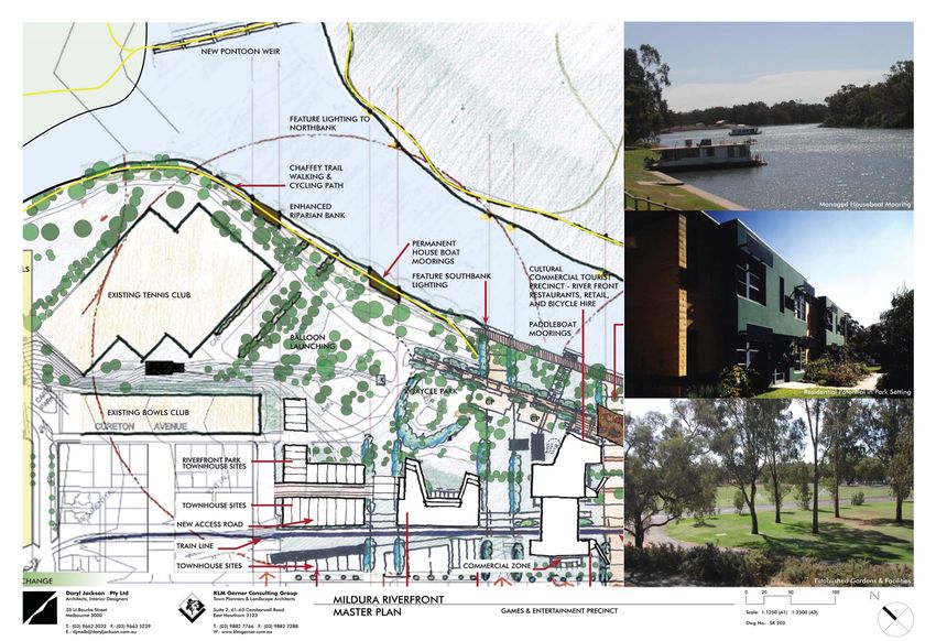
The Design Team

In April 2003 the Mildura Rural City Council selected a team led by renowned
Architect and Urban Designer DARY JACKSON to prepare this Masterplan study. The
study required a team of highly experienced professionals to cover a broad number
of disciplines and included:

Project Leader, Urban Designer and Architect        Daryl Jackson Pty Ltd
                                                    Architects and Urban Desginers

Town Planning and Landscape Architect               KLM Gerner Consulting Group

Feasibility Assessment                              Essential Economics

Environmental Consultants                           Enviroplan

Quantity Surveyors                                  Davis Langdon

Traffic Engineers                                   Ratio Consultants

The team have worked diligently to ensure each aspect of the Masterplan is
considered and resolved, resulting in this document outlining the potential for the
growth of Mildura as Victoria’s foremost riverfront city, and gateway to the Outback
experience.

Page: iii                                               Mildura Rural City Council
                                                            Riverfront Masterplan

                                                         Daryl Jackson Pty Ltd Architects
                                                           KLM Gerner Consulting Group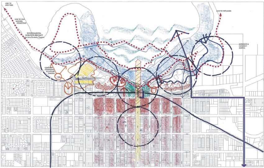
EXECUTIVE SUMMARY

A new large riverfront park and gardens for the City of Mildura is a critical regional initiative.
Designed to be an overlay across the existing 2.5km long riverbank setting, the scope of the
Mildura Riverfront Master Plan project may be seen to be of scale similar to Melbourne’s
Southbank or Adelaide’s North Terrace.

The Riverfront Park area edges the river on its south bank for some 400-800 meters back to
the cliff escarpment that defines the northern face of the city’s grid. The plan provides
guidelines for the design’s five 500-meter precincts, which together comprise Mildura’s
riverfront. Commissioned by the Mildura Rural City Council, Tourism Victoria and the
Department of Sustainability and Environment the Plan structure incorporates the proposed
Mildura Marina previously submitted to Council. Specific provisions covering the Mildura
Marina are now included in the Mildura Planning Scheme and the proponent is proceeding
with detailed design.                                                                                Dynamic potential to be fully realised

This Master Plan is required to bridge the gap between previous strategies and development
plans, and the State Government policy to provide a coherent action plan for a revitalised
forward looking Mildura Riverfront Park.

The Master Plan is an holistic detailed design focussed response to the site and its setting. It
includes guidelines for each riverfront precinct which, taken together, will produce an
integrated, harmonious park and river environs of great interest and value to both residents
and visitors.

The intent is to realise Mildura’s potential as a City by the River, to provide a quality
environment and built structures that complement each other and integrate well with the
surroundings. The result will be community focussed with a range of existing activities
retained and intensified to further celebrate and express the richness of the heritage,
environment, culture, leisure, entertainment and particular identity of Mildura as Victoria’s
most significant inland river city.

The design celebrates this relatively modern history, draws attention to the riverboat past
whilst including all existing uses; yet importantly seeks to signify a new beginning for Mildura
as Victoria’s foremost northern river city.

The riverfront is therefore seen as a cohesive and grand landscape element, through which
a number of defined activities and opportunities are found and developed, stimulating the            Potential for Riverfront Park
Riverfront Park as a lively and integrated part of the city. As a part of the City, the
connections back to the Mildura CBD are a key component of the success of the Riverfront
Park.

The major focus to the new riverfront park will be the Mildura Wharf Waterfront. This pivotal
urban structure will provide the main physical connection to the river, and will bring the
historic paddle steamers and public craft romantically close to the urban activity of the City.
Access by riverboats travelling the Murray will be possible, bringing them into a lively and
animated urban area with opportunities for food, wine, art, produce and people, each
brought together in a unifying gesture of the City, centred about the extension of Deakin
Avenue as a plaza extending to the river.

With relocation of the freight terminal, land will become available for other uses and better
integration between the City and Riverfront Park. A new Cultural Centre will be a central
focus for tourists and should incorporate an Indigenous Interpretative Centre. Located in
                                                                                                     Visitor, function and interpretative centre
Mildura, on the edge of the Outback, such a centre will enable tourists to conveniently and
safely explore the Outback experience, as well as gain a better understanding of Pre- white
settlement in Mildura and the history of Aboriginal Culture and legends in this area. The
centre would include scientific and research facilities in conjunction with specific Aboriginal
Cultural displays and events. This development will be unique in Australia (and the world),
since it will draw on regional characteristics and experiences and in this way would
generate nation wide interest, thus significantly stimulating tourism to this region. This centre
could be known as the “First Australians Centre” however this name would need to be
further reviewed in detailed feasibility work.

 Some distance away, the new conservatory and function centre will provide a new level of
service to the community, enjoying the surrounds of the river precinct

Some residential development in the form of townhouses, holiday units and apartments can
                                                                                                     Indigenous Art
provide a strengthening to the edge of the Park. The urban edge of the City along Seventh
Street can likewise be further developed and strengthened with landscaping and suitable
commercial and residential development of vacant sites, whilst within the Waterfront Park
opportunities that encourage greater patronage should be fully realized.

Open parkland is an attribute of the riverfront park to be enjoyed. The new Chaffey Water
Gardens provide a themed large open space, available for hosting public outdoor events
ranging from Balloon Events to New Years Eve Celebrations.

Connections with areas outside of this study area should not be overlooked. It is intended
that the Chaffey Trail be resurrected and formalized throughout the riverfront area in the
form of a walking and cycling discovery trail. It will connect other areas, including Lock
Island, Apex Park, The Old Mildura Homestead, and the Wetlands Area and indeed to other
areas further a-field such as Red Cliffs. The tracks will encourage movement along the river,
and will assist the protection of the natural landscape through defined walking and cycling
areas, whilst also providing encouragement for the embellishment of existing activities and
the creation of new opportunities.

Page 1                                                          Mildura Rural City Council
                                                                    Riverfront Masterplan

                                                                Daryl Jackson Pty Ltd Architects
                                                                  KLM Gerner Consulting Group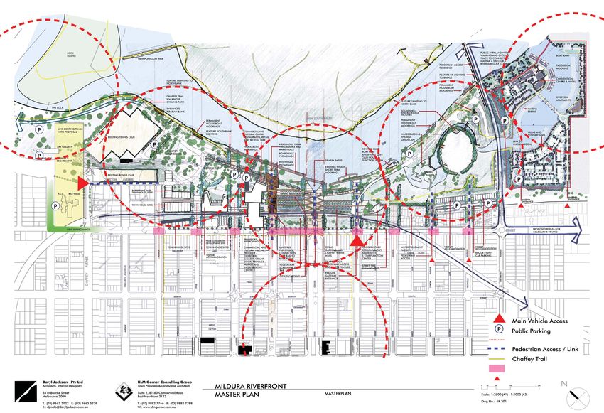
The activity generated by the new functions within the grand park setting will be of great
environmental, social, economic benefit to the community. It will yield increased
patronage and extended tourist visits, not to mention the improved amenity for residents to
enjoy everyday.

The Benefits

The economic benefits that are expected to be generated from the Masterplan are as
follows:

1.   Entertainment and Functions – Provision of a number of new sensitively designed and
     carefully integrated facilities including: Commercial and Cultural Centre including 4,500
     sqm of multipurpose exhibition, boutique tourist retail, information, arts, cafes and
     waterfront restaurants; a Function centre at the Garden Conservatory, enhanced
     riverfront facilities to support river traffic, improved and increased open space for
     outdoor events at the Chaffey Water Gardens including a sound shell, a defining              Paddle steamers and waterfront activity
     “Mildura Citrus Gardens” of state significance at the heart of the proposal, an improved
     transport interchange including commercial and retail development, and new
     residential housing in the form of townhouses, apartments and various modes of visitor
     accommodation.

2.   Residential Housing and Resident Spending - Residents in the new dwellings would
     support the local economy through annual retail spending of approximately $840,000
     pa (June 2003 dollars).

3.   Visitor Accommodation and Visitor Spending, including tourism - $7.4 million in spending
     by some 16,750 visitors staying on average 3.4 nights/visitor in the Riverfront visitor
     accommodation; and, $1.8 million of the visitor spending (25% of total spending) is likely
     to be on meals, shopping, gifts and souvenirs, thereby supporting local retailers.           dynamic landscape elements

4.   Employment generation - The implementation phase of the Riverfront Masterplan will
     involve investment of approximately $122 million, including both private and public
     investment in Riverfront components; Construction of the various components included
     in the Masterplan is estimated to generate a total of 1,190 job-years over the fifteen-
     year implementation phase. Most of these jobs are likely to be filled by workers living in
     the Mildura region. On-going employment generated through resident and tourism
     retail spending and in servicing visitor accommodation would be approximately 120
     direct, on-going jobs. Additional flow-on jobs would be generated through the
     employment multiplier effect. Approximately 275 jobs pa over the initial fifteen-year
     implementation phase plus 145 jobs pa on an on-going basis are likely to be generated
     in the local, State and national economies through the effects of the employment
     multiplier.

Overall, development of the Riverfront Masterplan area is expected to generate
considerable economic and employment benefits for the Mildura economy and for the
community. Consideration of the several components (residential, retail and visitor) in terms
of size of each component suggest that the forecast outcomes are achievable. This
includes contribution of the overall development to the residential market; additions to local    Market showcasing Mildura Produce
employment; and creation of new local spending for Mildura retailers.

Many social benefits to be enjoyed by the community will result from the Master Plan in
addition to those already appreciated by the community. These include:

         A more vibrant and active waterfront precinct, as an attractive urban place to visit
         for tourists and residents alike.
         An exciting marina focus for recreation and holiday makers
         A safer park environment with better lighting and more activity at all times during
         the day or night
         A broader understanding, both in the Community and to visitors, of the rich
         indigenous history of the area, through the new Indigenous Interpretative Centre.
         Passive overlooking with neighbouring residential buildings providing an unobtrusive
         façade that overlooks the Park
         Greater usage of the Park with lighting enabling it to operate well into the evening
         The pride of place, with the legacy of Mildura a key component of the Master Plan
         New facilities for dining, relaxing, playing and entertaining
         Expansion of art themes and movements in the area, particularly with respect to
         indigenous art.
         Eliminate the undesirable element from the Park through sound planning and
         lighting of new spaces
         A new rowing club and associated facilities
         A more pedestrian oriented waterfront, with walking and cycling trails inviting          Defining Citrus and Themed Gardens
         intimate contact with the landscape and less cars.
         Better connections to NSW and other areas of Victoria
         A range of garden themes that run through the precinct, ranging from the Mildura
         Citrus Gardens to the Chaffey Water Gardens

Ultimately, the opening up of visual and physical connections to the City will again link
Mildura with its tremendous waterfront, creating the potential for a natural riverfront park
with great opportunities realised, as a catalyst for patronage and activity, to be enjoyed by
residents and visitors alike.

The Mildura Riverfront Master Plan will enable a range of ‘sustainability benefits’ to be
achieved, addressing a broad range of issues including: Energy, Water, River Environment,
Materials, Health and Comfort, Awareness, Strategic Support.

                                                                                                  Conservatory and Function Centre
Page 2                                                        Mildura Rural City Council
                                                                  Riverfront Masterplan

                                                               Daryl Jackson Pty Ltd Architects
                                                                 KLM Gerner Consulting Group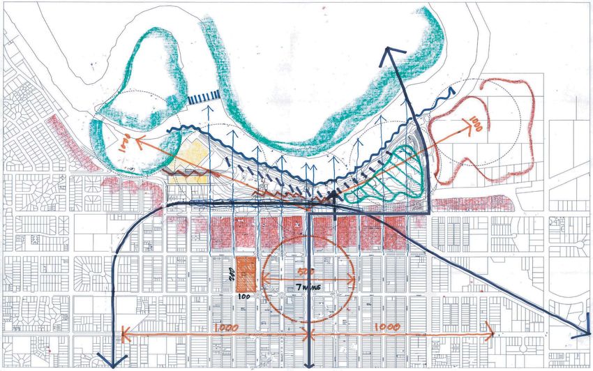
Finally, Urban Design Guidelines contained within this Master Plan ensure that the ongoing
development of the riverfront achieves the Master Plan vision in a unified manner over time.
The guidelines will ensure the Mildura riverfront, from the proposed Mildura Marina to Lock 11
and the Arts Precinct will read as one integrated design vision. These guidelines seek to
protect and enhance the economic, environmental and social attributes of the Mildura
Riverfront. They will also provide some certainty to the proposed Riverfront Advisory
Committee, stakeholders and potential developers of the level of design expected for this
special area.

The Urban Design Guidelines address the design objectives, desired character, and general
guidelines that must be achieved in order to satisfy the principle objectives listed above.
They are not intended to be prescriptive, but instead will be linked to the Mildura Planning
Scheme as a reference document that offers a performance-based system of control.

1.0       DESCRIBING THE MILDURA RIVERFRONT MASTER PLAN

This Master Plan was commissioned to ensure that riverfront development is consistent with
the vision of ‘a state significant precinct that is a destination in its own right’.

Sections 2.0 and 3.0, which follow, discuss how the Mildura Riverfront arrived in its present
form and outline its catchment potential and regional importance.

The critical juxtaposition of the riverfront to the City is recognised and reinforced. Based
upon an analysis of the natural and physical attributes of the riverfront and its urban context,
the Plan builds upon previous strategies and development plans (Section 4.0).

Section 5.0 outlines the aims and objectives of the study including identified opportunities
and constraints. This forms the basis for the recommendations illustrated in Section 6.0 ‘The
Masterplan Vision’. This provides the framework upon which the urban design outcomes
demanded for each precinct are based.

Section 7.0 outlines the economic, environmental and social benefits of the proposals to the
city, while Section 8.0 suggests actions, which enable the master plan to be implemented
over time.

1.1       USING THE MASTER PLAN

This Master Plan provides guidance for private developments, as well as public spaces on
the riverfront. It should be used by:

      Council staff when briefing or monitoring developers and their representatives on the
      design requirements for any land parcel within the Mildura Riverfront;

      Public or private sector agencies and their representatives to clearly understand the
      Council’s intent for the river front;

      Consultants engaged on Council’s behalf;

      By Council and agencies so that a rationalised and improved management structure
      and development control mechanism can be implemented;

      Any future riverfront authority or managing agency overseeing development proposals
      for the Waterfront Park.

      As the basis for referencing the Urban Design Guidelines in the Mildura Planning Scheme.

      Authorities in conjunction with other planning policies and strategies that exist.

It is envisaged that the Masterplan will be given status in the Mildura Planning Scheme by
reference in a Mildura Riverfront Plan Local Policy, the introduction of a Design
Development Overlay to key sites and some zoning modifications

Page 3                                                          Mildura Rural City Council
                                                                    Riverfront Masterplan

                                                                 Daryl Jackson Pty Ltd Architects
                                                                   KLM Gerner Consulting Group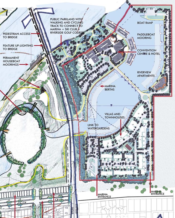
2.0      STORY LINE

Regional archaeological record indicates a semi-continuous Aboriginal occupation of the
Mid-Murray floodplain area dating back as far as 60, 000 years, and variously provides
evidence of shell fish gathering and processing, bark removal, tool manufacture and use,
and mortuary practices.

The World Heritage areas of the Willandra Lakes and Lake Mungo are only 110kms to the
north. Couple this together with the local significance of the Murray River – it was used as a
link by the Aborigines for carrying information and produce, and intersections with tributaries
were important (sometimes sacred) meeting places – this area has an amazing breadth of
Aboriginal history and legends upon which to draw.

Mary Woorlong was the last full blood member of the Latji Latji tribe to live in the Mildura
area. After her death in 1942, she was buried at the Mildura Cemetery signified by a
memorial stone, still seen to this day.

Mary’s father, Chief Woorlong was leader of the Latji Latji tribe and is renowned for his
boomerang throwing demonstration to Queen Victoria in England in 1900. However, having
been taken from Australia, Mary was likewise taken from her natural environment as a child
and trained as a servant. She was nonetheless well liked in the community and
affectionately remembered.

A number of places nearby should also be considered in understanding the quality of the
Indigenous history in this area:

      Hattah – Kulkyne National Park- Lake Mournpool was a primary occupation site of the
      Latji Latji people and includes scar trees and middens around the Lakes, and is rich in
      plant and animal specimens.

      Red Cliffs- The scenic reserve along the Murray River showcases evidence of the
      culture and heritage of aboriginal communities.

      Walpolla Island and Lindsay Island – were occupied by the Barkinji tribe along the
      Merbein Mail Route. Lindsay Island has the largest collection of Middens, burial sites
      and artefacts in North Western Victoria.

      Merbein Common is an ancient site that has Midden Specimens that date back to
      16,000 BC.

      Mungo National Park, part of the Willandra Lakes region, is included on the World
      Heritage List.

In this regard, Mildura may be considered to be a gateway to the Outback and the
Aboriginal experience

Early European settlers had stated that there was a large number of Aboriginal people on
both sides of the river when the original squatting station, Mildura Station, was first
established in 1846, as the Murray River corridor supported some of the densest Aboriginal
populations in Australia. The effects of European settlement on the Aboriginal population
were devastating however, and by 1862 the Aboriginal population in the Mildura area was
listed as only 49, and by the 1880's the number had been further reduced to 25-30.
Connections between the local Aboriginal Community, the land and traditional resources
are still maintained in the region nevertheless, and further acknowledged within the
Indigenous Land Use Agreement between the Latji Latji Peoples, the Wergaia Peoples and
Mildura Rural City Council, signed under the Native Title Act as part of the approval process
to the Mildura Marina amendment.

It is thought that the site area was occupied by the Keramin Aborigines before white
settlement. The first European in the vicinity was probably Charles Sturt who passed the
townsite on his journey along the Murray in 1830.

In the early 1880s, the Victorian Government began examining the possibility of establishing
irrigation colonies on the Murray River. A Royal Commission chaired by Alfred Deakin the
then Chief Secretary and Minister for Water Supply was held to examine Victoria's water
resources, and in 1884 Deakin led a delegation to the USA where he met the Canadian
born brothers George and W.B. (Ben) Chaffey. They had established irrigation colonies at
Ontario and Etiwanda, east of Los Angeles.

After a promising report in 1885 from Stephen Cureton (the Chaffey Brothers manager),
George Chaffey visited Victoria in 1886 and decided on the Mildura Run as a suitable
location for an irrigation colony. Psyche Bend Pumphouse contains the steam engines that
pumped water from the river to the fledgling settlement via open irrigation channels.

Prospective settlers or investors could purchase irrigated blocks for 20 pounds per acre. A
minimum of 10 acres and a maximum of 80 acres could be purchased by any individual.

By 1890 the colony had 3600 acres planted to horticulture. In these early years trees were
usually preferred to vines, with a typical block planted to 25% vines and the rest taken up by
apricots, peaches, lemons and oranges. By 1894 there were 700 acres of oranges, 750 acres
of lemons, 900 acres of peaches and 1650 acres of apricots.

The Chaffeys, especially George, invested in other business ventures in Mildura and
elsewhere. These included a brickworks, an engineering company, a timber mill and in 1888

Page 4                                                        Mildura Rural City Council
                                                                  Riverfront Masterplan

                                                               Daryl Jackson Pty Ltd Architects
                                                                 KLM Gerner Consulting Group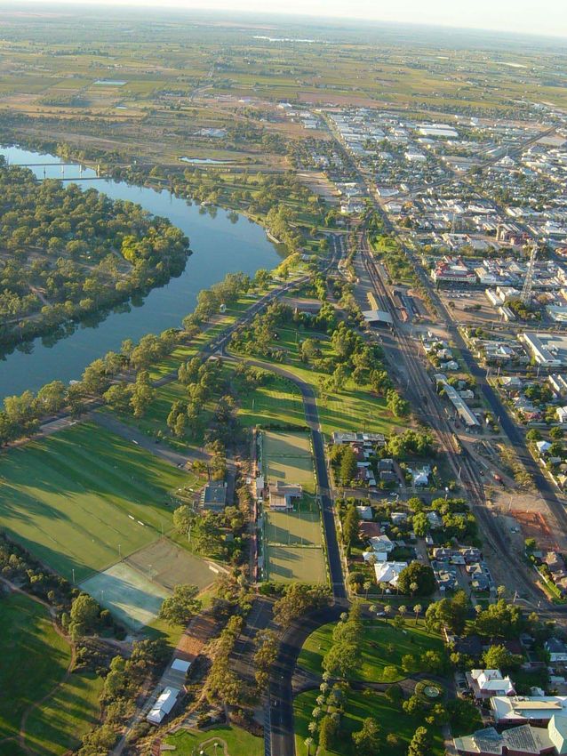
The River Murray Navigation Company. The original Chaffey family home, Rio Vista, is today
a museum and art gallery. In the early years of settlement, favourable conditions meant
Mildura could rely mostly on river transport with freight and passengers going downstream to
Morgan for a railway connection to Adelaide and upstream to Swan Hill and Echuca, for
connections to Melbourne.

The Mildura Wharf opposite the end of Madden Avenue is a pick-up point for paddle
steamers and showboats, recalling the days before the railways when the inland river trade
was a major means of intra-national transport. The Melbourne (1912) is still run by steam
power and you can watch the original boiler being stoked. Among its services, the Rothbury
(1881) makes weekly trips to Golden Zoo Park and Trentham Winery. The showboat Avoca
(1877) offers lunch and dinner, with music and dancing while the Coonawarra (1894)
undertakes cruises of 3-5 nights with accommodation.

A railway line through to Melbourne was completed in 1903, which greatly aided produce
transportation, and the town slowly crawled its way to prosperity with the help of the various
governments. The 1920’s were a time of considerable consolidation. 1000 soldier settlers
were granted land here after World War I, leading to the establishment of Merbein and a
general expansion.

3.0        THE CONTEXT OF MILDURA

Situated on the northwestern tip of Victoria, Mildura sits within the Murray Outback
Experience tourism region. The town edges the bank of the Mighty Murray River and,
despite its remote location, is well served by transport connections to major capital cities.

Mildura’s Central Business District serves a wide regional catchment covering the city of
Mildura and its satellite townships, and extends into New South Wales and South Australia to
serve a population approaching 50,000 residents, within a 1-hour travel distance by car.

In 1887 this region was the first irrigation colony to be established in Australia by the Chaffey
Brothers to create a diverse economic base focussed upon agricultural and horticultural
production. Today a gross value of $300 million per annum comprises the regional
economy.

A retail sector driven by a growing population (predicted to be 57,000 in 2021 1), with tourism
bringing approximately 918,000 tourists per annum to the region is significant.

A regional population catchment (representing a 2 hour drive, refer SK001) demonstrates
that the Mildura catchment within the Murray Outback tourism region is distinct from the
Echuca catchment within the Goulburn Murray region; Adelaide is a 4 hour drive and
Broken Hill a 2 ½ hour drive from Mildura; a 1 hour flight delivers the tourist from Melbourne to
Mildura airport.

The Mildura Airport has recently been upgraded to accommodate Boeing 737 aircraft.
Passenger Rail services are on the State Government agenda to return to the Mildura district
by 2004, however confirmation of this has yet to be received.

It needs to be remembered that the Murray River represents a key symbolic environmental,
economic and social asset to the township. However, broken connections to the river from
the City and the lack of a specific or unique riverfront park/ garden, currently undermine the
potential for Mildura to achieve its innate potential to become a key destination icon for the
regional community and incoming Australian and International tourists.

1
    Dept of Infrastructure – Victoria in Future January 2000

Page 5                                                         Mildura Rural City Council
                                                                   Riverfront Masterplan

                                                                Daryl Jackson Pty Ltd Architects
                                                                  KLM Gerner Consulting Group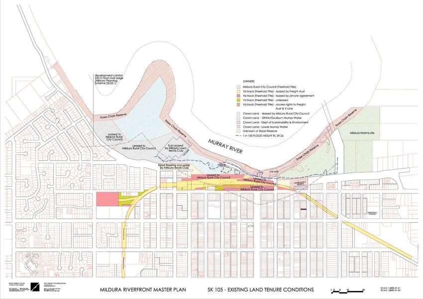
TO SYDNEY

                  11TH STREET

                  MAJOR EAST-WEST
                  CONNECTOR

 TO   MELBOURNE

                                    002
4.0 EXISTING ASSESSMENT
4.1 THE RIVER AND THE CITY: Rail and Riverboat
The Mildura Riverfront Reserve extends from the George Chaffey Bridge connecting Victoria
to New South Wales across the Murray River, to Lock Island that acts as a Murray River water
level regulator. The infrastructure in this area includes the Weir, and a Lock mechanism
(Lock 11) to allow river craft to traverse the two differing water levels. The proposed Marina
development east of the George Chaffey Bridge is to be integrated with the riverfront site to
produce a cohesive design that will function as a whole across its 2500 metre length.
The existing rail infrastructure slices through the site impeding physical access and visual
connection between the City and the river. Rail freight activity for the region is centred here
presenting a significant constraint to achievement of the Master Plan. This Master Plan
strongly endorses Council’s resolution to support relocation of the rail freight terminal to the
proposed new Freight Gate in line with the recommendations of the North West Freight
Transport Strategy. Lock 11 infrastructure with Lock Island in the
background
The river itself presents a unique opportunity for Mildura to capitalise upon riverboat activity.
Currently there are four paddle steamers operating from the Mildura Wharf, facilitating tours
along the Murray River. Private Houseboats are moored along the riverbank, as are
houseboats for hire, presenting greater tourist potential. This river craft activity is however
creating environmental problems with degradation of the riverbank due to designated
mooring sites having inadequate provision for passenger alighting and disembarking. The
proposed Marina will address some of these issues.
The riverfront is host to a number of active sporting pursuits and community uses. The leasing
arrangements between Council and these clubs should continue into the future to provide
sporting and cultural activities to the local population. Open space areas should also be
retained and enhanced for passive activities occurring on the riverfront such as walking and
cycling, picnicking and ball games, and nature appreciation.
A significant number of agencies and stakeholders have an interest in the riverfront precinct.
This presents Council with a complex application and resolution process. Coupled with a
number of different ownership and lease rights, issues of land tenure and development Paddle steamer ‘PS Melbourne’ docked at
controls is paramount to the success of the Master Plan vision. Mildura Wharf
The riverfront is currently a series of separate spaces, each with separate functions
connected only by Hugh King Drive, a physically dominant road, and the river itself. Each of
these separate functions is integral to the effective operation of the riverfront and the City.
They should be retained, consolidated or relocated to better service the visual and physical
connectivity of the riverfront. Further detail has been discussed in the below sub-sections.
4.1.1 ACTIVITIES AND USES
The Mildura riverfront accommodates a number of uses varying from active sporting facilities
to passive recreation opportunities, from community groups to city infrastructure.
The Clubs and Groups currently utilising the riverfront are:
Mildura Lawn Tennis Club
Mildura Rowing Club
Rio Vista House at Walnut Avenue and Cureton
Mildura Bowls Club
Avenue intersection
Mildura Art Club
Mildura Little Theatre
Red Cliffs Musical Society
St Johns Ambulance
Infrastructure currently in use on the riverfront:
Mildura Rail Yards and associated infrastructure
Mildura Railway Station (transport interchange)
George Chaffey Bridge to New South Wales
Lower Murray Water Pump House on river bank (town water)
Lower Murray Water Treatment Facility (town water)
Amenity blocks at Ornamental Lakes and Jaycee Park
Old Power House (community use)
Lock 11 and the Weir to maintain water levels for river traffic
Jaycee Park playground
Skate Park
Rowing Clubrooms
Rio Vista House
Art Gallery with Elliot Collection beside Rio Vista
Mildura Theatre and Ampitheatre
4.1.2 VISUAL ASSESSMENT
The riverfront at Mildura has experienced significant European settlement since the late 19th
century. Originally a working port for cargo delivered by river craft and transferred to rail,
the Riverfront is a highly modified landscape that retains little trace of its natural state. It is
visually and functionally disjointed.
River Red Gum character
Stately River Red Gums provide glimpses of the water and create a visual buffer between
the urban parkland and the river. However, utilitarian structures litter the parkland, providing
Page 6 Mildura Rural City Council
Riverfront Masterplan
Daryl Jackson Pty Ltd Architects
KLM Gerner Consulting Groupsporting clubrooms, ageing infrastructure and amenity blocks. Community groups use some
converted historic buildings, and these too are in need of reparation and representation.
Large expanses of lawn dotted with both Eucalypts and European trees characterise the
riverfront from the Chaffey Bridge past the Mildura Lawn Tennis Club to Lock 11, providing a
well maintained landscape setting. Hugh King Drive, a four-lane bitumen road, cuts through
this grassed area visually dominating the site, as well as inviting unwanted use as a micro
drag track from time to time.
Mildura Rowing Club Lawns and Hugh King
The potential to capture river views from the City edge is impeded by the main rail line and Drive from elevated pedestrian walkway
freight gate located at the top of a terraced crib wall escarpment planted with succulents.
This is a visual blight on the reserve.
East of the Chaffey Bridge is the site of the proposed marina. A highly modified low-lying
scrubland surrounds a retention basin, yet to be created.
4.1.3 VEHICULAR TRAFFIC AND PARKING
(Refer Figure SK104 – Existing traffic and carparking)
The existing vehicular usage of the riverfront has been researched, focussing on road
networks, local access and traffic management, carparking and bus access and parking.
(a) Road Network
The Riverfront area is currently separated from the Mildura CBD by:
The reservation and traffic lanes of Seventh Street;
The railway line and freight yards.
Between Deakin Avenue and San Mateo Avenue, Seventh Street is classified as the Sturt
Highway. As such, it is signed as a major interstate traffic route and it is used in that way,
especially by trucks. This through/truck traffic role increases the severity of the barrier that
Seventh Street creates between the CBD and the riverfront.
The railway line cuts the northwest extension of Seventh Street. This means that CBD access Vehicular parking at the Mildura Wharf takes up
traffic from the north-west must deviate around the “missing link” of Seventh Street, either: prime riverfront land
Along Cureton Avenue, in between the Rio Vista Mansion and Rio Vista Park; or
Along Eighth Street on the southern side of Mansell Reserve.
There are prospects of these major traffic/transport barriers being removed in the near
future, as part of road/rail infrastructure changes, as follows:
The impact of through-traffic, particular truck traffic on the amenity of Deakin Avenue
could be reduced if Benetook Avenue were to be designated as a Truck Route;
The railway line may be cut back, terminating at a point south of the CBD.
These two changes would allow a more direct and convenient functional linkage between
the CBD and the Riverfront, and re-establishment of the full road grid (i.e. Seventh Street)
north-west of the CBD.
(b) Local Access and Traffic Management
The main vehicular access for the riverfront is available via Hugh King Drive, which is On street parallel parking on Seventh Street
connected:
Into Madden Avenue (under the railway line at a level crossing);
Into Cureton Avenue at the western end.
There is little data available relating to existing access and traffic management
characteristics of the riverfront area. The following summary data provides a partial
description:
There are some roads in the riverfront precinct with excessively wide pavements, such as
Hugh King Drive and the road serving the rail freight loading areas;
The western part of Hugh King Drive (Madden Avenue to Hodges Way) carries about
1,000 vehicles per day; surveys in August 2003 show that about half of the traffic
exceeds the 40km/h limit, with the maximum observed speed being 86km/h;
The eastern part of Hugh King Drive (Madden Avenue to the bridge) carries about 500
vehicles per day; surveys in August 2003 show that about one third of the traffic exceeds
the 40km/h limit, with the maximum observed speed being 105km/h;
Tourist bus access to the Port of Mildura wharf area can only be achieved from the Madden Avenue entrance (under rail line)
western end of Hugh King Drive.
Page 7 Mildura Rural City Council
Riverfront Masterplan
Daryl Jackson Pty Ltd Architects
KLM Gerner Consulting Group(c) Car Parking
There are numerous areas of off-street public parking in the Riverfront Precinct, namely:
Mildura Wharf 63 spaces
Arts Centre 57 spaces)
Lock Island 70 spaces
Riovista Park 39 spaces
Jaycee Park 31 spaces
Riovista Park Lookout 63 spaces
These areas, plus on-street parking along Hugh King Drive and overflow areas near the
tennis courts, provide sufficient parking for current needs.
(d) Bus Access and Parking.
Sealed car park at Rio Vista Park lookout on
Buses require access to the wharf (and associated parking) for groups of people boarding Cureton Avenue
River Murray paddle steamer tours; up to five buses are parked at the wharf at peak tourist
times, within the designated wharf carpark.
Vicroads have advised that a detailed traffic impact assessment will be required as part of
the development of the project, and will need to address both vehicular and pedestrian
movements.
4.1.4 RIVER TRAFFIC AND MOORING
The Mildura Port activities are one of the defining elements of the waterfront area, unique to
Mildura. The wharf caters for:
Paddle Steamer Cruises
River Cruise Boats
The existing wharf incorporates the historic wharf, which is spread over 3 levels, 1 of which
has been submerged since the introduction of the Lock and Weir has raised the river level.
The historic wharf should remain and be protected as it is of great interest for those
occasions when the water does recede sufficiently.
The wharf is located at this position in the river primarily because the width is greatest, and it
is a good distance from the Weir. This facilitates the large turning circle of the paddle
steamers and gives them sufficient time to correct and regain control, should they stall. Mildura Wharf catering for paddle steamers and
Historically, it was also the highest piece of ground at the riverfront, in close proximity to the river cruisers
City.
The major paddle steamers using the river and wharf facilities include both independently
geared paddle steamers as well as rudder steering only steamers. The turning circle of both
differs, with the rudder requiring a greater turning circle arc. As such, the natural river
current is relied on to assist the steering, and therefore they currently turn in an anti-
clockwise direction.
4.1.5 PEDESTRIANS AND BICYCLES
The Chaffey Trail established along the Three Chain Reserve on the riverfront provides linear
access to the water. Currently a shared gravel trail up to 2.4 metres wide is used by
pedestrians and cyclists, extending well beyond the riverfront park in each direction. The
trail connects Apex Park to the west to the Old Mildura Homestead, Lock 11, the Rowing
Club Lawns and beneath the Chaffey Bridge to connect the proposed Marina site to the
key urban waterfront area.
North-south connections are fragmented and often difficult to negotiate. There are
footpath connections from the City to the riverfront along Madden Avenue under the rail
overpass and Chaffey Avenue at an at-grade rail crossing.
A pedestrian bridge crosses over the rail line at Deakin Avenue affording views of the river
and City edge. This bridge contains steps to negotiate the succulent garden embankment Chaffey Trail in bushland character between
to arrive at the wide bitumen roadway of Hugh King Drive and the Rowing Club Lawns Tennis Club and Lock 11
beyond. This does not facilitate effective pedestrian and bicycle access particularly
disability and aged persons' access.
Visitors currently engage in a drive – park – explore experience. The number of parking
spaces provided along Hugh King Drive demonstrates this. The site is not conducive to
direct pedestrian and bicycle access from the City.
4.1.6 LANDSCAPE CHARACTER
Seventh Street provides a distinctive landscape character with an established avenue of
Palms. Council has undertaken works to infill this avenue to provide a continuous edge to
the street. This is a positive improvement to the interface between the City and the
Waterfront Park.
The two defined entrances to the riverfront at the Madden Avenue rail underpass and the
north west Cureton Avenue entrance do not display ‘Gateway’ qualities befitting the
resource that lies behind it.
Page 8 Mildura Rural City Council
Riverfront Masterplan
Daryl Jackson Pty Ltd Architects
KLM Gerner Consulting Group- EXISTING CONDITIONS
003The site itself displays five landscape characteristics and land use patterns that can be
defined as:
1. Degraded bushland and river level management– Lock 11, the outdoor theatre and
reconstructed Mallee flora planting;
2. Active recreation / structured grassland – the Tennis and Bowling Clubs and Jaycee
Reserve;
3. Semi-developed urban – adjacent to Mildura CBD, with the existing wharf, riverboat
presence and Rowing Club
4. Grassy informal open space – Ornamental Lakes and picnic area, concert, games and
circus venue;
5. Natural character - highly disturbed stormwater retention basins – the proposed Marina
site.
Mildura Marina site: degraded bushland
The Mildura Riverfront is dissected by Hugh King Drive and the rail line with little (or no easily
apparent) connection from the City to the riverfront, some 10 meters below and up to 400
meters away. Similarly, the landscape character is fragmented across the site with no
theme to connect useable spaces. The river bank itself has some riparian species and
remnant tree species such as Eucalyptus camaldulensis (River Red Gum), that should be
protected and enhanced.
Species selection across the remainder of the site is not consistent with undefined patches of
exotic trees within a predominant Eucalyptus upper canopy. Large expanses of lawn
serving as passive open space provides a consistent ground treatment. However irrigation
requirements are high. Council has identified that in Council managed reserves the total
amount of lawn should be reduced to 60%. This is related to Council’s strategy for all new
developments.
The concrete crib wall that negotiates the level transition between the rail yards and the
riverfront reserve contains succulents planted more than thirty years ago that now look tired Ornamental Lakes: established Eucalypts
and out of character. This concrete wall is failing and will require replacement. This creates and irrigated lawn
an opportunity to improve the transition and create a notable new and exciting pedestrian
connection from the city to the riverfront, with ramped pathways and appropriate “Mildura
Inspired” planting and gardens.
Council has fenced the concrete edged Ornamental Lakes due to safety concerns during
times of inundation. This is out of character with the open grassy plains feel of this space, as
well as out of scale with the concept for a great urban park. A safer water body could be
sculptured here that does not conflict with the use of the area for large informal events. The
vision demands a scale and quality more akin to Adelaide’s Torrens River parkland or
Melbourne’s Botanic Gardens, than to a suburban inspired streetscape.
4.1.7 SUSTAINABILITY
The study area includes five different precincts, each of which possesses identifiable Succulent plantings in concrete retaining wall
qualities and characteristics. Much of the natural environment is highly modified, having on embankment between Hugh King Drive
been cleared and degraded, particularly for past industrial uses and, in some instances, ill and the rail line
informed and ugly physical infrastructure requirements.
The uses within the study area have over time become less utilitarian and more focussed on
community activities and intrinsic values: hence the concern about its sustainable state.
Degraded natural and habitat values, water quality and land use issues, current
management and maintenance arrangements all contribute to this existing condition.
The Mildura Riverfront Masterplan provides the opportunity to address sustainability issues
across environmental, social and economic realms; and demands a management intention
and organisation to bring about the desired result.
General IssuesBased on an inspection of the study area and public consultation exchanges
and outcomes, a number of general principles and sustainability issues are identified.
Riparian Strip
The south-western bank of the Murray River is significantly degraded. Much of the
embankment is devoid of vegetation, which leaves soil exposed to rain and wind erosion.
These areas also contain little remnant under-storey and middle-storey vegetation, so there
is inadequate vegetation to provide habitat for many fauna species. Where the ground-
storey is degraded the role of vegetation in filtering stormwater prior to it entering the river is
also diminished.
An additional element affecting the Murray River embankment areas is the mooring of
boats. This activity is causing erosion due to people engaged in boating activities tying up
directly to the riverbanks and walking up and down the embankments. This appears to be
quite an ad hoc, informal arrangement.
Erosion Ad-hoc licensed moorings of houseboats
A significant embankment is located along much of the western side of the Study Area. have degraded the riverbank edge
Various treatments and approaches have been applied to retain the embankment and
prevent erosion, which has met with varying levels of success at both functional and
aesthetic levels. In parts the embankment is subject to erosion, caused both by exposed
soil, steep batters, and informal paths.
Page 9 Mildura Rural City Council
Riverfront Masterplan
Daryl Jackson Pty Ltd Architects
KLM Gerner Consulting GroupWEIR
Unexciting
Bridge
Lock
Degraded
Riverfront
Tennis Attractive
Parkland
Degraded Bowls
Vegetation Jaycee
Park
Degraded V egetation
Water
Treatment
KLM Gerner Consulting Group
Architects, Interior Designers Town Planners & Landscape Architects
35 Lt.Bourke Street Suite 2, 61-63 Camberwell R oad EXISTING CONDITIONS
MASTER PLAN Scale: 1:4000 (A1) 1:8000 (A3)
Melbourne 3000 East Hawthorn 3123
Dwg No.: SK 101
T.: (03) 9662 3022 F .: (03) 9663 5239 T.: (03) 9882 7766 F .: (03) 9882 7288
E.: djmelb@daryljackson.com.au W.: www .klmgerner .com.auWeeds
Weeds including willows, that are displacing opportunities for indigenous vegetation affect
parts of the site. This is particularly the case in degraded areas also affected by erosion.
Effects of the Weir/Lock
The presence of the weir/lock structures at the north-western side of the study area has
obviously had impacts on River Murray water levels, flows, the river banks and aquatic life.
This includes its functioning as a barrier for migratory fish species and other aquatic-life. A
characteristic of this area is brought about by the variability of levels and flows in the weir
pool, which can occur on a daily, weekly, monthly and seasonal basis.
The weir also provides Lower Murray Water with access to the river to supply water for the
Mildura Township.
Stormwater
Stormwater is generated from run-off within the study area, from roofs, paved and grassed
areas. It is also generated from urban properties outside the study area (in Mildura’s CBD),
which drain into the study area by overland flow or subsurface drains. While main drains
have been fitted with gross pollutant traps, there is no other filtration or treatment of
stormwater prior to it entering the river.
Floods
The study area is subject to periodic flooding. Floods of the nature of the 1 in 100 year 1956
flood form an important part of the character of the area and will occur again at some
time, with the potential to inundate large sections of the river frontage for several weeks.
It is important to recognise this natural characteristic in the Master Plan from an historical
and environmental perspective, and any development in the area will need to satisfy the
flood constraints. The existing Flood Awareness Trail on Lock Island provides and
opportunity for interpretation as part of the overall trail and interpretive system.
The Murray River Frontage Action Plan presents the broad aims and objectives for
development along the river frontage from Robinvale to Merbein and the Masterplan
provides the opportunity to address these in the Study Area.
Non-indigenous Bird-life
Substantial numbers of non-indigenous bird species can be observed in the study area.
These may fulfil a scavenging role, feeding on waste and scraps originating from human
activities both within and outside the study area, but the birds may also take food from
natural sources. There is likelihood that other bird species could be displaced because of
the large populations of these birds.
There are problems associated with pigeons inhabiting Pheonix Canarensis. This particular
palm is favourite for pigeons locally, which cause significant problems throughout Urban
Mildura. This particular palm is therefore to be avoided for this project. Other palm species
such as Jubaea, Chilensis, Washington Robusta and Filifera should be used in preference.
Anti-Social Behaviour
Parts of the riverbank are used as a “hang-out”, and feedback from consultation sessions
suggests that alcohol-related, anti-social behaviour occurs at various locations throughout
the study area.
Communication with User Groups
The study area is divided between many different owners and types of tenure. This makes
communication between the public, community groups and landowners and managers a
complex exercise.
4.1.8 PRECINCT ISSUES
Whereas the above issues apply across precinct boundaries, other issues are particular to
precincts. These are described below.
1 The Arts and Lock Precinct Aerial photography of the Arts and Lock
In comparison to other precincts, the Lock Precinct has many natural qualities. There is a Precinct with significant tree cover but little
significant amount of tree cover. However the under-storey and middle-storey is quite understorey vegetation for wildlife habitat
degraded or absent in parts. At present many paths are quite informal, and this has
contributed to disturbance of vegetation and local erosion.
This precinct also contains the Lock and Weir. These obviously modify the river’s water levels
and flow regime.
2 Games and Entertainment Precinct
This precinct is dominated by the presence of Mildura Lawn Tennis Club, Mildura Bowling
Club and Jaycee Park. Substantial lawn areas are maintained and irrigated for these
facilities and the Park has been developed with playground equipment and
passive/informal recreation areas. Another prominent activity is the mooring of boats along
the bank of the Murray, which in this location has contributed to bank erosion and poor
vegetation quality. Another contributing factor to this is the unrestricted and fully informal
access to the riverbank.
Consequently, the precinct is highly modified, with little native vegetation. This is evidently
also due to the site’s industrial past.
Degraded landscape of the proposed
Mildura Marina site
Page 10 Mildura Rural City Council
Riverfront Masterplan
Daryl Jackson Pty Ltd Architects
KLM Gerner Consulting GroupOne of the major issues for this precinct is the environmental management of the operation
of facilities. Stormwater runoff (quantity and quality), use of fertilisers and chemicals, energy
and water use, weed and erosion control are some of the matters that (if they are not
already being considered) should be addressed in environmental management plans.
3. Port of Mildura Precinct
The Port of Mildura Precinct is and will continue to be the most ‘urbanised’ of the riverfront
precincts. Any natural qualities have been overtaken by development of paved areas,
buildings and non-indigenous landscaped areas. This has generated stormwater runoff
issues, particularly in terms of the quality of water.
4. Chaffey Water Gardens Precinct
This precinct mainly comprises an undulating grassed area bounded by Hugh King Drive
and the river to the north and embankments, crib walling to the south-east and south-west.
It is currently known as Ornamental Lakes Park due to the existence of a dated, concrete
“water feature”. The sustainability issues for this area include the extent of watering, mowing
required for the grassed areas, and the lack of any practical ecological function for the
“water feature”.
5. Marina Precinct
Plans for the Mildura Marina have been developed over a long period of time, prior to
commencement of the Mildura Riverfront Masterplan project. Issues are therefore centred
on integration with the surrounding area, and in particular with the Chaffey Gardens
Precinct. These matters include stormwater runoff and water quality, and consistency in
sustainability objectives or guidelines applied to other built form and development in the
study area.
Central Business District Precinct
It is considered that the primary sustainability issue arising from the Central Business District
(CBD) precinct is its role as a contributing source for stormwater runoff. The extent of roofs
and paved areas creates substantial runoff in rainfall events, and the stormwater also carries
litter and pollutants away from the CBD. While gross pollutant traps have been installed on
main drains, fine litter and pollutants still flow into the Murray River.
4.1.9 LAND TENURE AND DEVELOPMENT CONTROLS
(Refer Figure SK 105 – Existing Land Tenure Controls)
General Comment
The land tenure arrangements and development control provisions that apply to the study
area are complex. This section summarises the existing situation and highlights the main
issues related to managing potential changes to the existing use and development in the
area.
The information that is outlined is based on an assembly of information from several sources.
It is possible that there are inaccuracies in the comments that are made. It is noted that, at
present, there is no consolidated up to date accurate data base with information about
existing physical conditions (including contours, critical levels, site features), location of the
NSW-Victorian border, leases, sub leases and licences, responsibilities of different agencies
involved in managing or controlling activities in the study area.
There are several areas within the study area that will require significant investigation and
potentially legislative amendments to simplify coordinated management of the riverfront
area. The establishment of a single land manager could address many of the complexities
that exist as a result of the overlapping responsibilities and roles of the various agencies.
It will be necessary for full title searches to be undertaken to determine the ownership of
several of the freehold titles.
Agencies include:
Mildura Rural City Council – Planning Authority, land owner and manager.
Lower Murray Water – Water supply agency.
Goulburn Murray Water – Land manager.
VicRoads – Sturt Highway.
Mallee Catchment Management Authority (Vic).
Wentworth Shire Council.
Department of Infrastructure and Natural Resources (NSW) – Murray River access and
works.
Murray Darling Basin Commission – Murray River.
NSW Waterways – Murray River access and boat use.
Sunraysia Rural Water Authority – Water supply.
VicTrack – Rail land.
Department of Sustainability and Environment
State Boundary
The border between NSW and Victoria is defined as the high water mark in 1859. It is
understood that the top of the bank as it exists now may not correspond with the original
bank position. This has created some confusion about the jurisdiction of controls that apply
to the mooring of vessels and the construction of works along the bank and into the river.
Some survey work has been undertaken by Mildura Rural City Council to define the current
bank edge but this has not been completed or integrated with other survey information.
Liaison with the Surveyor General (Victoria) will be required to confirm the definition of the
Page 11 Mildura Rural City Council
Riverfront Masterplan
Daryl Jackson Pty Ltd Architects
KLM Gerner Consulting GroupState boundary and the dimensions of the sixty metre permanent public purpose reserve (ie
‘Three Chain Reserve’). This is also referred to below.
It is understood that there have been discussions between various agencies aimed at
reaching agreement about a contemporary definition of the bank and the border.
The location of the bank shown on the accompanying maps is based on information
provided by Council and Department of Sustainability and Environment and may not be the
final location that is established by survey.
Mooring Licences
These were issued to individual boat owners by NSW Department of Land and Water
Conservation and allow permanent mooring against the southern bank at defined
locations. The Department may agree to the relocation of these to another part of the
Study Area consistent with the Master Plan.
About 12 licences remain. Once surrendered by the current holders they will not be
renewed. They are not transferable.
Short Term Mooring Rights
There are also several positions where boats may moor for a short time (a few hours) to
provide owners with access to the shore.
Constructions within River
The approval of several NSW agencies is required for structures within the Murray River in
NSW.
Land Tenure
Figure SK105 shows the various categories of land tenure in the study area. Most of the study
area is Crown Land, administered by the Department of Sustainability and Environment
(DSE), leased to various agencies. With the exception of some freehold titles that face roads
at the edge of the Study Area the whole of the study area is Crown Land, most of which has
been delegated for management to other agencies.
However, the area around the Weir and Lock is Crown Land vested in control of State Rivers
and Water Supply Commission (or its successor, namely Goulbum Murray Water. SRWA has
no role in land tenure or management here.)
It is intended that the area to be developed for the Mildura Marina Resort, which is currently
freehold title owned by Mildura Rural City Council, will be sold to the Marina developer.
Murray River Permanent Public Purpose Reserve
There is a permanent reserve for a depth of 60 metres (‘Three Chain Reserve’) along the
southern edge of the Murray River. The exact location of the edge of the reserve is
dependent on the definition of the southern bank. The approximate definition of the reserve
is shown on Figure SK105 (shown in red hatch). As noted above, consultation will be
required with the Surveyor General (Victoria) about the definition of this reserve.
No structures may be constructed within the reserve without approval from DSE.
A site has been leased to the Mildura Rowing Club at the centre of the Study Area.
Mildura Rowing Club
The Club is located within the Public Purposes Reserve. Whether the Rowing Club is
relocated or not, its occupation should be formalised by a lease under Section 17D of the
Crown Land (Reserves) Act 1978.
Ministerial approval will be required for any relocation and will be subject to conditions.
Commercial activity is not encouraged on the reserve and this would apply to the club
house, if relocated.
Design restrictions may be applied through the issue of a planning permit and approval of
the Mallee Catchment Authority will be necessary if the club house is relocated.
Flood Line
Much of the study area forms part of a flood plain comprised of two distinct forms. The first
is floodway land, which is the component of the floodplain that is generally the high
hazard portion that should remain free from obstruction during major flood events in order
to provide adequate flood conveyance.
Significant development restrictions apply to the floodway land, which is designated Urban
Floodway Zone (UFZ) for freehold land and Floodway Overlay (FO) for public land areas in
the Mildura Planning Scheme.
The second part of the flood plain is the flood fringe area, which is subject to fewer
hazards than the floodway and generally floods to depths less than 500mm. A Land
Subject to Inundation Overlay under the Mildura Planning Scheme affects this area.
Flooding restrictions usually involve the requirement for residential or commercial
development (other than a Class 10 building) to be constructed 300mm above the 1%
flood level (or the 100 year Average Recurrence Interval (ARI) level, which is commonly
referred to as a 300mm freeboard. This level is identified in Figure SK105 at RL39.26 and is
defined as the 1956 flood level.
Page 12 Mildura Rural City Council
Riverfront Masterplan
Daryl Jackson Pty Ltd Architects
KLM Gerner Consulting GroupYou can also read