Final Plan - Lower Kananaskis River - Barrier Lake Redevelopment Bow Valley Provincial Park - Alberta Whitewater Association
←
→
Page content transcription
If your browser does not render page correctly, please read the page content below

Lower Kananaskis River –
                           Barrier Lake
                      Redevelopment
                  Bow Valley Provincial Park

                  Where water recreation meets nature conservation

                           Final Plan
AUGUST 16, 2018
Alberta Environment and Parks, Government of Alberta
August 16, 2018
Lower Kananaskis River – Barrier Lake Redevelopment Final Plan
Alberta Parks, Kananaskis Region
Canmore, AB

2                                                                LKR-Barrier Redevelopment | Final Plan

Table of Contents

1.0 Introduction ............................................................................................................................... 4

   1.1 Project Area Vision and Planning Principles .......................................................................... 5

   1.2 Overall Project Objectives ..................................................................................................... 9

2.0 Rationale.................................................................................................................................. 12

3.0 Location and Existing Facilities ............................................................................................ 14

4.0 Project Details ........................................................................................................................ 18

   4.1 Alternatives Considered....................................................................................................... 19

   4.2 Canoe Meadows Day Use Area and Group Camp.............................................................. 22

   4.3 Kananaskis Visitor Information Centre and Day Use Area .................................................. 32

   4.4 Widowmaker Day Use Area ................................................................................................. 38

   4.5 Barrier Lake Day Use Areas ................................................................................................. 42

   4.6 Project Schedule .................................................................................................................. 54

5.0 Background ............................................................................................................................. 55

   5.1 Legislation and Policy .......................................................................................................... 55

   5.2 Dispositions and Adjacent Land Use .................................................................................. 59

   5.3 Socio-Economic Considerations ......................................................................................... 59

   5.4 Environmental Considerations ............................................................................................. 67

   5.5 Historical Resources ............................................................................................................ 75

   5.6 Evaluation and Monitoring ................................................................................................... 80

   5.7 Future Considerations ......................................................................................................... 81

6.0 Involving Albertans ................................................................................................................. 82

   6.1 Targeted Stakeholder Input ................................................................................................. 82

   6.2 First Nations Consultation ................................................................................................... 83

7.0 References .............................................................................................................................. 84

LKR-Barrier Redevelopment | Final Plan                                                                                                          3
1.0 Introduction

Alberta Parks will redevelop several day use areas and a group campsite along the Lower
Kananaskis River (LKR) to Barrier Lake. These upgrades will address concerns regarding user
conflict, ecological impacts, traffic congestion, and increased accessibility to this important
water-recreation destination. By planning at the landscape scale, the LKR-Barrier Project will
also provide opportunities to address the diversity of uses in this area and work with
stakeholders to ensure facilities meet user needs effectively. This plan has been created to
represent the build-out of this area for the foreseeable future. Alberta Parks recognizes that
given current ecological sensitivities and social carrying capacity, future facility development
beyond this plan is not recommended.

In 2011, the Lower Kananaskis River Redevelopment Plan was presented to the Alberta public
for consultation. Significant areas of controversy surrounded some of the components of that
plan, particularly the installation of large campgrounds. This current plan went out for public
consultation from August 27 to October 27 2017; First Nations consultation with all Treaty 7
Nations was conducted over a similar time frame. The final version of the LKR-Barrier plan
presented here was influenced by the public consultation results in 2011 and 2017, and a
detailed environmental review. A list of final facility changes described in this plan can be found
in Section 1.1.5: Overall Project Decisions.

This plan applies a landscape scale approach to planning facilitates, addressing ecological
values, and fostering water-based recreation values. This project plan includes Canoe Meadows
day use and group camping area, Kananaskis Visitor Centre day use area, the Widowmaker day
use area, the Barrier Lake day use areas. The Barrier Dam day use area was also considered
during the planning process, but the extent of changes were not significantly different from the
2011 proposal. Barrier Dam day use area upgrades are contained in a separate project plan.

This planning document is extensive in scope and detail. Information is presented for the area on
a whole and then for each site individually. Sections have been written to be integrated but also
independent of each other; pertinent attachments are contained at the end of each section
rather than the end of the document.

4                                                                  LKR-Barrier Redevelopment | Final Plan
1.1 Project Area Vision and Planning Principles
Given the popularity of the LKR area and its
ecological importance, Alberta Parks                Project Area Vision
created an overall guiding vision that could
                                                    The Lower Kananaskis River – Barrier
help define a long-term management
                                                    area in Bow Valley Provincial Park
strategy and intent for the entire area from
                                                    supports an important wildlife movement
Canoe Meadows to Barrier Lake. The vision
                                                    pathway, rare habitat types, and other
and planning principles define the
                                                    important ecological values; it is a unique
management strategy and intent for the
                                                    destination in the Alberta Parks system
next 50 years; they were designed through
                                                    where visitors from around the world
conversations with representative Alberta
                                                    come to appreciate and enjoy world-
Parks staff from visitor services, ecology,
                                                    class whitewater and lake-based
trails, conservation officers, education,
                                                    recreation activities in a natural parks
permitting, and facilities management.
                                                    setting.

1.1.1 Mission Statement

Using science-based decision making, Alberta Parks will enhance visitor experience and protect
the LKR-Barrier area to provide ecologically sustainable recreation for current and future
generations.

1.1.2 Management Characteristics

The characteristics defined here are embodied by Alberta Parks staff and the stakeholders who
manage or directly influence the visitor experience and ecological integrity of the LKR-Barrier
project area. These characteristics guide our work in addressing the subsequent management
principles and focus areas.

    1. Equality of user groups
       There are a variety of user groups interested in water-based recreation activities in the
         project area. All user groups should have equal access to their chosen recreational
         activity, and no user group will be considered a higher priority than another.

    2. Critical thinking
       The project area is complex from social, ecological, and economic perspectives. Finding
         ways to balance these needs is essential to meet project objectives. Planning and
         management decisions should be holistic and based on the best available social and
         ecological scientific information.

LKR-Barrier Redevelopment | Final Plan                                                             5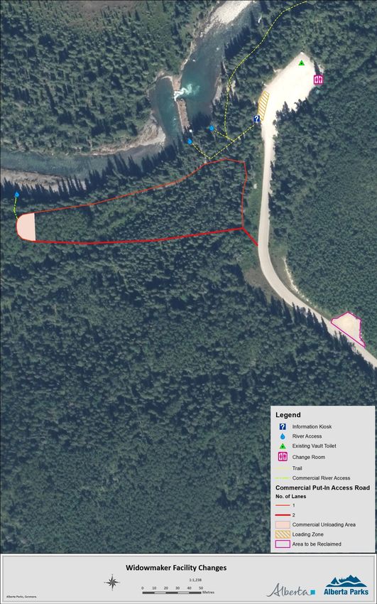
3. Collaboration and respect
       With the diversity of user demands and ecological sensitivities of the project area,
        managers and stakeholders will practice good listening skills and show consideration of
        each other’s perspectives and needs.

    4. Flexible and adaptable
       Water levels in Barrier Lake and the LKR are subject to large fluctuations due to flood
        and drought mitigation measures, climate change and other processes. In addition,
        ecological and social science data are continually evolving and changing our
        understanding of the landscape. Planners, managers, and stakeholders should be
        flexible and adaptable to these changing conditions in both the short and long term.

1.1.3 Planning and Management Principles

Planning and management principles provide a foundation for the overall recreation
management strategy and bring a high degree of consistency to the decision-making process.
Principles are designed to help achieve the vision and integrate recreation planning efforts with
other management priorities throughout the project area. The below principles align with the
existing Bow Valley Provincial Park management plan (Bow Valley Protected Areas Management
Plan, 2002) and its direct reference to the LKR and Barrier area.

    1. Enhancing ecological integrity
       Local wildlife movement pathways provide north-south connectivity adjacent to Highway
        40 and east-west connectivity from Mt. Baldy across the Widowmaker area to Bow
        Valley Wildland Provincial Park. These movement pathways connect important and rare
        habitat patches and serve as vital routes for multiple species. Planning and management
        of the LKR-Barrier area will prioritize the long-term sustainability and effectiveness of
        wildlife habitat and connectivity. All recreational activity planning will be considered
        within the context of the ecological sensitivities of this landscape.

    2. Public safety on trails and in the water
       Ensuring public safety in this area is paramount from both the visitor and Alberta Parks
        perspectives. Recreation planning and management will consider the specialized skill
        set required for recreation on the Lower Kananaskis River and the risks associated with
        cold-water recreation. Trails connecting sites will be planned to ensure user safety and
        enjoyment.

    3. Sustainable recreational opportunities for diverse user groups
       The current Bow Valley Provincial Park management plan states the need to integrate
        the recreational needs of commercial guiding and instructional groups, non-profit clubs,
        and educational groups with general public recreation needs. Incorporating the diversity

6                                                                   LKR-Barrier Redevelopment | Final Plan
of recreational activities offered, reducing potential user conflict, and ensuring Albertans
         and commercial operators have adequate, sustainable access to their activity of choice
         is important.

    4. Improved communication
       Planning in the LKR-Barrier area will endeavor to reduce user conflict through signage
         and designating activities to specific areas. Communicating project plan outcomes (e.g.,
         through signage, websites, or the Kananaskis Visitor Information Centre) will be integral
         to providing quality visitor experiences. The Kananaskis Visitor Information Centre day
         will act as an information hub for Kananaskis Country.

    5. Working with stakeholders and First Nations
       Alberta Parks is committed to working with TransAlta Utilities, concerned stakeholders
         (e.g., LKRUA, commercial operators), and First Nations to ensure that planning and
         management activities consider all interests in a fair, open, consultative decision-making
         process.

1.1.4 Strategic Objectives

Strategic area objectives contribute to meeting the area vision and are intended to provide
management direction within the context of the planning and management principles for the
entire project area.

Table 1: Project Planning and Management Principles and Associated Objectives

   Planning and            Objective
   Management
   Principle

   Enhancing ecological    Ensure wildlife movement pathway effectiveness
   integrity
                           Work with Alberta Transportation to decrease wildlife-vehicle collisions by investigating
                           speed reductions and/or installing deceleration lanes on Highway 40

                           Maintain ecological integrity of habitat patches by ensuring impacts associated with
                           recreational activities are kept to a minimum

                           Reclaim the banks of the Lower Kananaskis River to reduce erosion; explore feasibility of
                           reestablishing ground cover

                           Ensure trails in the area avoid sensitive habitat and are planned to reduce recreational
                           impacts to ecological resources

LKR-Barrier Redevelopment | Final Plan                                                                                 7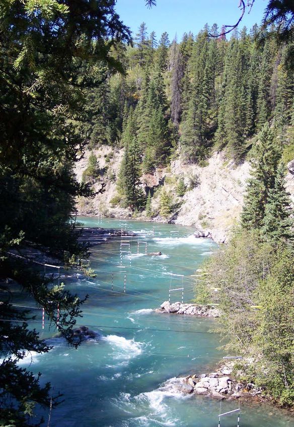
Design facilities to have a minimal ecological footprint and retain the natural setting
                              characteristic of provincial parks

    Public safety on trails   Build trails to avoid cliffs or steep slopes that may present a risk to public safety
    and in the water
                              Install better signage communicating the risks of cold water recreation and LKR water
                              release schedule

    Sustainable recreation    Design and construct facilities that appeal to specific user groups in appropriate locations
    opportunities for
    diverse user groups       Plan facilities that reduce user conflict by separating users and allowing all groups to have
                              their space

                              Increase user friendliness by modernizing facilities and increasing parking capacity

                              Provide change rooms and ample washroom facilities at day use sites

                              Improve camping options and facilities at Canoe Meadows that are more appropriate for
                              the paddling community and reduce potential user conflict

                              Install bicycle-specific storage facilities at day use areas and work with Alberta
                              Transportation to potentially provide a safe cycling route through the project area

    Improved                  Change signage and online materials to better reflect the diversity of recreational activities
    communications            and where they are most appropriate

                              Use the Kananaskis Visitor Information Centre and day use area as a hub for information
                              pertaining to the project area

                              Develop interpretive signage sharing watershed stewardship and conservation messaging
                              at all sites

                              Develop a sense of place for visitors to understand they are in the Kananaskis Country
                              protected area system

                              Market Barrier Lake as a non-motorized and motorized lake recreation site

    Engaging with             Continue working with Alberta Environment and TransAlta to ensure water levels in Barrier
    Stakeholders and First    Lake and the LKR meet various objectives and commitments (e.g., water flow, stabilization
    Nations                   of water levels)

                              Involve stakeholders (e.g., LKRUA) in the planning and management processes

                              Work with Treaty 7 First Nations to incorporate traditional uses, knowledge, and concerns in
                              planning and management

8                                                                                    LKR-Barrier Redevelopment | Final Plan
1.2 Overall Project Objectives
This project area has reached a social carrying capacity associated with the diversity and
number of users on the LKR and Barrier Lake. The ecological sensitivities of this area have been
well documented in terms of wildlife movement and habitat use. The best way to effectively
balance ecological and social needs in this area is to place limits on future development. This
plan represents the final development of this area from Canoe Meadows to Barrier Lake.

The LKR is a recreation destination largely
due to the constructed rock and cement
structures in the river bed that channel
water to create white-water features.
These features have undergone extensive
review by Water Act prior to construction
and contribute to improving the overall
recreation experience. The proliferation of
these features has increased human use
on the LKR and adjacent lands, which has
led to increased impacts on the area’s
ecological attributes. This plan details
significant changes to staging areas and
river access points to help reduce
ecological impact. To monitor the
effectiveness of these changes and how
they impact human use patterns of the
LKR area, Alberta Parks is implementing
a moratorium on future development of
river features for a period of 5 years.

The final project plan presented here also contains several facility improvements:

    1. Entire Project Area
           • Improved signage that is consistent in messaging and appearance at all sites;
           • “Share the Road” signage from Canoe Meadows to Barrier Lake to
               accommodate bikes;
           • Zoning changes to better define facility and natural area zones. Facility zone
               boundaries will follow facility footprints once construction associated with the
               plan is complete. *

LKR-Barrier Redevelopment | Final Plan                                                            9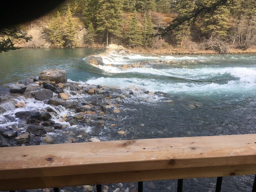
2. Canoe Meadows Day Use Area and Group Camp
           • Expanded and formalized public parking area;
           • Working with Alberta Transportation to investigate the installation of
              deceleration lanes on Highway 40;
           • A new camping area with individually bookable walk-in tenting sites *;
           • No comfort camping*.
           • A training and meeting centre (private/public sector opportunity);.
           • Upgrades to the group campground, including a new group shelter and
              formalized tent pads;
           • An accessible trail and river put-in;
           • Formalized pedestrian access to the river that does not go through the group
              camp*;
           • Installation of two open air change rooms – one in the main parking area and
              another in the camping area*;
           • Installation of gear drying racks in the day use area.

     3. Kananaskis Visitor Centre and Day Use Area
           • Expanded parking and designated parking areas for carpoolers and visitor
              centre users;
           • Conduct a hazard tree assessment. Use areas with extensive tree removal as
              guidelines for new parking area expansions;
           • A river surfer staging area with small parking area, surf board rack, and picnic
              opportunities;
           • No “surf zone” will be designated, but signage along the river will alert users to
              approaching standing waves. Signage along the river banks will detail etiquette
              for people using standing waves*;
           • Installation of a heated change room at the surfer staging area.

     4. Widowmaker Day Use Area
           • Formalized public parking;
           • Relocation of the trail kiosk;
           • A new commercial operator put-in located upstream*.

     5. Barrier Lake Day Use Area
           • A new hand boat-launch and associated road access;
           • A water sports equipment rental hut (private sector opportunity;
           • Expanded parking;
           • Tourism development opportunity (private sector opportunity);
           • Decommissioning half of the access loop road, under used pull-out parking, and
                under-used trails;
           • Construction of a Connection Corner trail;
           • Barrier Lake’s name will not change, but the name of the day use areas will be
                amended*;

10                                                               LKR-Barrier Redevelopment | Final Plan
• Improved picnicking opportunities;
• Stairs for beach access to reduce bank erosion;
• Better delineation of wildlife habitat areas where human use is discouraged*.
* amended based on results of public and First Nations consultation.
All plan element details are subject to detailed design, technical investigations, and
environmental review Level II.
LKR-Barrier Redevelopment | Final Plan 112.0 Rationale
In 2011, the Alberta Government released the Lower Kananaskis River Facility Redevelopment
Proposal. This redevelopment plan proposed the following changes:
• Canoe Meadows – upgrades to group camping facilities, better separation of day
users and group camping, improvements to accommodate special events, parking
expansion, trail improvements, and a new campground.
• Kananaskis Visitor Centre – construction of a campground on either side of visitor
center with 75 new sites, and expansion of the day use parking lot.
• Widowmaker – construction of a new campground with 109 sites, 3 group use sites, a
new staging area for water entry, and a new group use area with a campground.
• Barrier Dam – expanded parking, installation of a boat launch, and a disc golf course.
The subsequent comprehensive ecological review conducted by Alberta Parks raised significant
concerns with the scope of the plan. Ecological concerns centered on the potential impacts to
wildlife movement through the area, increased human-wildlife conflict associated with the
proliferation of campgrounds, and the loss of rare habitats in the area. The results of the public
consultation process in 2011 showed a high level of public support for facility upgrades and
improvement but less unanimous support for the proposed extent of campgrounds and the disc
golf course. Based on these factors, the following aspects are no longer contained in this
redevelopment plan:
• Campgrounds and expansion of parking lot at Widowmaker
• Campgrounds at Kananaskis Visitor Centre
• Disc golf course at Barrier Dam
The reasons for developing the 2011 plan are largely still relevant. There is a need to improve the
visitor experience through the expansion and modernization of recreational facilities in an
environmentally sensitive manner. The area has already been recognized for its river-based
recreational opportunities, but in past years has also become increasingly popular as a picnic
and lake-side recreation destination. There is a growing diversity of users across the project
area. User groups include white-water paddlers of all kinds, river surfers, flat water paddlers,
beach goers, picnickers, stand-up paddle boarders, and various commercial operators offering
all of the above.
Many of the facilities in this area were built in the 1980s when Alberta was home to a smaller
population who engaged in different styles of recreation. With Alberta’s growing population and
improvements in outdoor recreation equipment, the number of visitors to the LKR-Barrier area
has increased and their expectations regarding provided services have changed. Current
12 LKR-Barrier Redevelopment | Final Planfacilities and associated parking lots are frequently over-capacity and out of date, thus failing to meet the needs of changing demographics. Enhancing facilities to better meet user expectations will improve the visitor experience in the area. With these facility upgrades, there is an opportunity to increase the accessibility of the river and lake-based recreation for Albertans with reduced mobility. Facility upgrades can also enhance ecological integrity by focusing human use away from wildlife movement pathways and designating water access points to reduce bank erosion. One of the key issues with this area is parking capacity. Current parking lots are not designed to effectively maximize existing space and are sometimes too small; this plan details parking lot expansions. Another key issue is growing user conflict, particularly at Canoe Meadows where group camp and day users are frequently attempting to use the same space at the same time. This is particularly challenging when a wedding or other special event has booked the group camp area and is interrupted by day users. Separating overnight and day users at Canoe Meadows is a focus of this plan. There is a lack of camping capacity in Kananaskis Country and this plan explores additional camping opportunities in the LKR- Barrier Lake area. Positioning the LKR as a world-class white water paddling destination requires productive partnerships with members of the Lower Kananaskis River User Association (LKRUA). LKRUA has been engaged throughout this planning process and their perspectives are incorporated throughout. More current and extensive ecological data demonstrates the importance of this area for wildlife movement and habitat. Planning to increase the effectiveness of movement pathways and improve habitat security is an essential component to this plan. The LKR-Barrier project area represents an opportunity to increase ecological integrity and improve visitor experience. LKR-Barrier Redevelopment | Final Plan 13
3.0 Location and Existing Facilities
The project area spans 6 km in length from Canoe Meadows day use area to Barrier Lake day
use areas. The day use sites of Canoe Meadows, Kananaskis Visitor Centre, and Widowmaker
border the Lower Kananaskis River, which starts just below the Barrier Dam. The Barrier Lake
day use areas are on the south-eastern shores of Barrier Lake, above the dam. The project area
is bordered by the Lower Kananaskis River and Barrier Reservoir on the west side and Highway
40 on the east. While the project area is quite narrow, all developments were considered in the
context of the surrounding landscape from an ecological and social perspective.

The legal area description of each day use area is (Attachment 3.0.1: Project Area ATS Map):
     •   Canoe Meadows – section 23-024-08 W5M
     •   Kananaskis Visitor Centre – section 14-024-08 W5M
     •   Widowmaker – section 15-024-08 W5M
     •   Barrier Lake (lower portion of day use area) – section 9-024-08 W5M
     •   Barrier Lake (upper portion of day use area) – section 5-024-08 W5M

The project area is located less than 5 km from the Stoney Nation Reserve on its northern end
and is the first part of Kananaskis Country encountered when traveling south on Highway 40
from the TransCanada Highway (Attachment 3.0.2: Regional Project Map). These day use areas
serve as gateways to the Kananaskis Country protected areas system from the north end
because of their proximity to the TransCanada Highway. As such, these areas attract a variety of
day users ranging from experienced white-water athletes to casual picnickers and everyone in
between. The area is also one of the only places in Kananaskis Country with highly accessible
and diverse water-based recreation opportunities. As a result of its location and recreational
characteristics, the project area is very busy.

The length of Highway 40 from Nakiska ski area to Highway 1 acts as a wildlife movement
pathway, particularly for grizzly and black bears. This wildlife movement pathway connects
habitat in the Nakiska ski hill area to the Bow Valley Habitat Patch north west of Barrier Lake and
adjacent to Canoe Meadows area. Throughout this project area are critical aspen forest habitat
patches, which comprise only 3% of the landscape within Kananaskis Country protected areas
and the Bow Valley. These aspen forests provide critical ungulate habitat, particularly in the
winter, and songbird nesting habitat in the summer. Avoiding these critical habitats is important
in design and site construction. There are several species at risk found in the project area,
including harlequin ducks, grizzly bears, and rare plants. Ensuring their habitats are protected is
essential to plan success.

14                                                                 LKR-Barrier Redevelopment | Final Plan
There are several existing facilities throughout the project area:
1. Canoe Meadows – day use, overnight use, special events
• A day use parking area with vault toilet
• Day use meadow with picnic tables
• Trail surrounding site with access to the river
• Group camp with shelter, fire pits, and picnic tables (managed by the Alberta
Whitewater Association)
2. Kananaskis Visitor Centre – day use, information centre
• Visitor centre parking lot with vault toilet
• Outdoor kiosks with area information
• Picnic tables in forest and open meadow
• Smaller parking pullouts with forested picnic tables in the surrounds
• Sani-dump station
3. Widowmaker – day use
• Parking area with vault toilet
• River access points above and below Widowmaker feature
4. Barrier Lake – upper and lower day use areas
a. Lower day use area
• Motorized boat launch
• Large parking area with vault toilet
• Picnic tables and beach access
• Trail linking to upper day use area
b. Upper day use area
• Parking area
• Picnic tables in the forest
• Trail to upper viewpoint with interpretive signage
All of these sites have several associated commercial operating and guiding permits for paddling
and water-based recreational activities. The river and reservoir denote the boundary from Bow
Valley Provincial Park to Bow Valley Wildland Provincial Park where a few hiking and mountain
biking trails are available. The east side of Highway 40 is on Alberta public lands.
LKR-Barrier Redevelopment | Final Plan 15Attachment 3.0.1: Project Area ATS 16 LKR-Barrier Redevelopment | Final Plan
Attachment 3.0.2: Regional Project Map

LKR-Barrier Redevelopment | Final Plan   17
4.0 Project Details
The following section provides recommendations at the project area scale; site-specific
recommendations follow in sub-sections. Given the scope of this project, the site-specific
sections have been written to be independent of each other in their own sections with
conceptual lay-outs, recommendations, and attachments.

Several aspects of the proposed changes are required at all or several sites across the project
area:

     1. Improved signage
        Alberta Parks will create a signage plan for this project area that will increase clarity and
         provide consistency regarding which activities are most suitable at each site. Signage
         will help create a sense of place for visitors to the LKR-Barrier area. Common signage
         will contain the project area tagline: where water recreation meets nature conservation.

         Signage can be used to communicate the theme of this area before people even reach
         Canoe Meadows. A sign on the highway could detail all sites in the area and visually
         communicate the types of recreation they provide. This may help visitors to select the
         best day use area for the activities they are most interested in.

         In addition to standard Alberta Parks wildlife and safety messaging, signage will focus
         on:
               •   Watershed stewardship
               •   Cold water recreation safety
               •   River class and implications for inexperienced paddlers
               •   Site-specific maps with designated trails and water access points
               •   Map of overall LKR-Barrier project area with areas of ecological importance

     2. Install paddling specific storage at some day-use areas
         With the focus on water-based recreation, Canoe Meadows and the Visitor Centre sites
         will contain a selection of drying racks near picnic areas. Surf board racks will be
         provided at the Kananaskis Visitor Centre surfing staging area and a boat rack will be
         provided at the Canoe Meadows group camp. The provision of these amenities will
         contribute to establishing this area as a water-based recreation destination through
         visual cues.

18                                                                  LKR-Barrier Redevelopment | Final Plan
3. Improve bike related infrastructure and accessibility
Alberta Parks is committed to working with Alberta Transportation to explore the
designation of a safe biking route from Canoe Meadows to Barrier Lake along Highway
40. This will provide safer access for the increasing numbers of road cyclists using
Highway 40 and for paddlers shuttling between Canoe Meadows and Widowmaker.
Signage along the highway should reflect that the shoulder is a shared route. This is
discussed more in Section 5.6: Transportation and Utilities. Bike racks will be installed at
several sites.
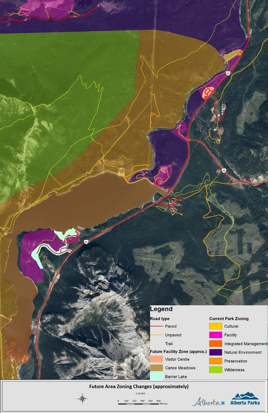
4. Zoning changes
Currently, Facility Zoning surrounds all day use areas, the area between Canoe
Meadows and the Kananaskis Visitor Centre, and much of the Barrier Lake area
peninsula. The remainder of the project area is zoned as Natural Area. The current
management plan (2002) commits to refining these zones to better reflect the
development footprint once this facility plan is finalized. The zoning changes will better
reflect human use and current wildlife movement and habitat data. The Facility Zones at
Canoe Meadows, Kananaskis Visitor Centre, and Barrier Lake will be restricted to the
extent of development. All other areas will be zoned as Natural Area or Preservation
(Attachment 4.0.1: Proposed Area Zoning Changes). Zoning changes will better
compliment other existing zoning and contain future development.
4.1 Alternatives Considered
There are several alternatives for the overall project plan that were considered prior to defining
the site-specific details (Table 2: Alternatives Considered). Site-specific project components,
conceptual lay-outs, and alternatives considered follow in the subsequent sections.
Table 2: Alternatives Considered
Alternative Description Considerations
Maintain existing Leave all • Does not address growing demand and lack of
state existing capacity.
facilities at day
use areas. • Does not incorporate current ecological data in
area use and facility planning.
• The diversity of recreational uses could be better
planned on a site-specific basis.
• Current parking lots and facility design do not
address vehicle and user congestion.
LKR-Barrier Redevelopment | Final Plan 19Option 1 – Upgrade • Updates and modernizes existing facilities.
Upgrade existing
facilities only • Does not account for increased human use patterns
and new recreational use patterns.
Option 2 – Implement the • Plan has already been the subject of extensive
Implement 2011 2011 Lower public and stakeholder consultation.
LKR Kananaskis
Redevelopment River • Extensive work was completed to create this draft
plan Redevelopment plan and it is critical that these efforts are not
Plan as duplicated.
proposed • Plan was created prior to an extensive
environmental review. Current ecological and
wildlife data should be used when planning at this
scale; the 2011 plan contains components that are
no longer considered ecologically appropriate.
• New recreational uses have arisen since the
creation of this plan (e.g., river surfing).
• The extent of camping proposed in this plan is not
appropriate to achieve ecological and public safety
related objectives.
Option 3 – The current • Updates 2011 plan based on current ecological
Current Plan proposal: Lower data.
Proposal Kananaskis
River – Barrier • Engaged with stakeholders throughout planning
Lake process.
Redevelopment • Recommends planning measures for the larger
Plan landscape, including Barrier Lake.
• Proposes more appropriate developments in the
context of public safety and ecological issues.
• Plan contains long-term, comprehensive recreation
management strategies for the project area.
• Addresses new forms of recreation and increases in
use.
20 LKR-Barrier Redevelopment | Final PlanAttachment 4.0.1 Area Zoning Changes LKR-Barrier Redevelopment | Final Plan 21
4.2 Canoe Meadows Day Use Area and Group Camp
Canoe Meadows is a triangular shaped area bordered by the Lower Kananaskis River on two
sides and Highway 40 on its eastern edge. This is the first day use area people encounter when
arriving in Kananaskis Country and it is the most popular staging area for paddlers in the LKR-
Barrier project area. It experiences very high use levels and requires substantial changes and
upgrades. A significant contributor to its popularity is the proliferation of human constructed
white water features in this portion of the LKR, including a white-water slalom course regularly
used by athletes and for special events (e.g., races). The 5-year moratorium on river
developments does not apply to maintenance of these existing features. The Canoe Meadows
group camp, operated by the Alberta Whitewater Association (AWA), is currently used as a
staging area for special events and group camping. With the significant changes being planned
for this area, Alberta Parks will work with the AWA to revise their operating agreement for the
campground and its components.

4.2.1 Current Situation and
Changes

The AWA and the Alberta Slalom Canoe
Kayak (ASCK) have constructed a gate
system for a kayak slalom course on the
LKR adjacent to Canoe Meadows. This
course compliments the white water river
features constructed by AWA between
Widowmaker and Canoe Meadows over
the past several decades. Together these
features make the LKR and Canoe
Meadows a destination of international
significance for the white-water paddling
community. This facility has hosted an
array of regional, national, and
international competitions and events.
Canoe Meadows is considered the
provincial training facility for the sport of
kayaking.

The existing gravel parking lot can
accommodate approximately 70 vehicles

22                                                                 LKR-Barrier Redevelopment | Final Plan
with one vault toilet and garbage facilities. The group camp area is located next to the main
parking area and currently shares the one vault toilet. The group area is not well defined or
separated from the day use area; this can lead to conflict between day users and those who
have paid to book the group use area.
The current Canoe Meadows parking lot does not have capacity to satisfy user demand. The
group camp is outdated and delineation between it and the day use area is unclear. The
opportunity to construct a training facility may help position this area as a world-class white-
water destination.
Alberta Parks will implement the following changes to day use at Canoe Meadows:
• Provide a public/private sector opportunity to construct a white-water training facility
• Construct an accessible trail and accessible river put-in
• Expand and pave the parking lot to increase capacity and efficiency
• Install several drying racks in the day use area meadow
• Install a change room
• Designate a trail for pedestrian river access away from the group camp
Alberta Parks will implement the following changes to overnight use at Canoe Meadows:
• Install several tent pads along the edge of the meadow
• Replace and upgrade the existing group shelter
• Install a small parking lot with access to 10 individually bookable, walk-in tent sites
• Install additional vault toilets and a change room specific to the camping area
• Use signage to better delineate the separation between the group camp and day use
areas
• Install gear drying racks and a canoe/kayak storage rack
In addition, Alberta Parks proposes to amend the Facility Zone to more closely surround the
facilities associated with human use (e.g., buildings, parking lots). Everything outside of this
Facility Zone will be designated as Natural Area or Preservation Zone because of this area’s
importance for wildlife connectivity. The Facility Zone is tightly bound to the existing facility
footprint and does not include the River Walk trail and other trails accessing the river. Trails are
permitted within Natural Area zones and will not be affected through this zoning. The zoning will,
however, prevent any further facility development along the river shore line. The proposed
Facility Zone boundary has been designed to maximize available habitat for wildlife movement
along Highway 40.
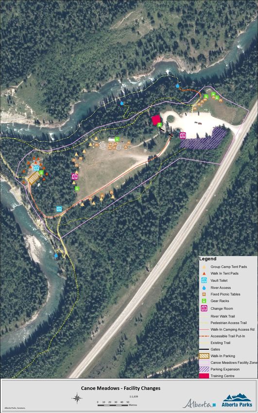
Attachment 4.2.1: Canoe Meadows Proposed Changes details the changes to facilities and
zoning at this site.
LKR-Barrier Redevelopment | Final Plan 234.2.2 Specific Changes
This section describes the recommendations for the Canoe Meadows portion of the Project
area. Additional considerations to support the following recommendations are provided in
Section 5.0: Background.
Upgrades to facilities associated with day use
1. Parking Lot
The parking lot will be expanded and formalized to increase capacity for approximately 150
vehicles; this may require relocating the vault toilet. The turn-around at the west edge of the
parking lot should be signed as “no parking”. Given the popularity of this day use area, Alberta
Parks will consider having cameras installed to monitor this parking area.
Specifics:
• Total area = 3,826m2 = 1,400m2 (expansion) + 2,426m2 (current)
• Pave and formalize lot with painted lines
• Minimum 6 pull-through spots
• Loading zone adjacent to day use meadow and in front of training centre
2. Change room
Stakeholders raised concerns regarding the lack of a facility to change in to their paddling gear.
This is also an issue for other day users who may feel awkward when paddlers change in the
parking lot. The change room will be designed to
contribute to the area’s sense of place by
including paddling specific elements (e.g., simple
towel racks, chairs, and designs such as in the
pictures below). Any accessories should be
designed for easy maintenance and repair in the
event they are vandalized.
Paddling themed change room design and details such as towel racks and hooks can help
establish Canoe Meadows as a paddling focused area.
24 LKR-Barrier Redevelopment | Final PlanSpecifics:
• Open air with two stalls
• Close to vault toilet
• Paddling theme and
appearance
• Floor drains to prevent
water accumulation
3. Gear racks and storage
Installing visual cues, such as paddling
specific infrastructure design or
signage, is a significant contributor to
creating a sense of place. Gear storage
racks can be useful to dry equipment
before transporting it in a vehicle, while contributing to the area’s sense of place. Examples of
storage racks are provided in the pictures below. Picnic tables will also be placed around the
edges of the meadow. With picnic tables and gear racks, this meadow will be positioned as a
good gathering spot for paddlers. Alberta Parks' logos should be added to all storage and drying
racks.
A simple paddle rack
and multi-purpose
drying rack can be
used for pfds,
wetsuits, and other
equipment and can
help establish a
sense of place at
Canoe Meadows.
Specifics:
• Install 3 in day use meadow near trail head
• Use generic multi-use pegs and hooks to accommodate a variety of paddling
gear (e.g., PFDs, paddles, wetsuits)
• Low maintenance to withstand weather and potential vandals
• Be a simple structure, partially covered, with no walls
LKR-Barrier Redevelopment | Final Plan 254. Private/Public sector opportunity – White-water training centre
The original redevelopment plan in 2011 recommended the construction of a year-round training
and meeting centre to accommodate the growing demand for white-water training facilities. This
training and meeting centre would provide a space for athletes to gather and serve as a central
facility for special events. The size and scope of this facility are limited by the lack of power and
running potable water at Canoe Meadows. The current plan designates an area of approximately
1,500 square feet for this facility, which will be the subject of a Non-profit Recreational Lease or
a Facility Lease. Parks Division will invite the interested parties to submit a proposal for design,
construction, and operations of this facility. The RFP will detail facility requirements and will
focus on developing a facility that is economically feasible, meets the needs of paddlers, and fits
within the context of Alberta Parks management objectives.
This facility, containing meeting and
equipment storage space, will be
located adjacent to the main parking LEED Building Standards
lot turn around to ensure visibility and Leadership in Energy and Environmental Design
ease of access. The allotted area will (LEED) is an internationally recognized
include indoor and outdoor facilities, environmental program. LEED building strategies
are: sustainable site development, water savings,
including covered and secured
energy efficiency, materials selection, and indoor
outdoor equipment storage, outdoor
environmental quality.
gear storage area, and an indoor
meeting space. The facility may There are four different levels of certification that a
contain a small concession, however, developer can attain for a building: certified, silver,
it cannot contain a full kitchen due to gold, and platinum. The level of certification is
dependent on the number of points accumulated in
the lack of available water licenses.
the design and construction phases of the project.
The outdoor areas will not require
heating, but may require lighting for More information about LEED and the application
the winter months. The meeting and process can be found at:
classroom space will require electricity
The Canada Green Building Council
and heating, the mechanisms of which
can be determined during the design LEED Canada Reference Guide for Green Building
phase. Alberta Parks will encourage Design and Construction 2009
potential proponents to designing a
facility that meets LEED green building
standards.
Design of the training centre should also visually demonstrate the area’s paddling and water
recreation theme. This can be done through building design and architecture, providing they
26 LKR-Barrier Redevelopment | Final Planfollow the Kananaskis Improvement District Architectural Guidelines. Photos of other paddling
centres below highlight some examples of how external storage, and design elements can be
used to establish a sense of place and communicate to visitors that this is a paddling area.
Specifics:
• Approximate size 1,500 sq. ft.
• Contains 5 areas:
o Covered and enclosed outdoor equipment storage space
o Meeting/ classroom (approximately 600 sq. ft. for 30-50 people)
o Office
o Small concession
o Indoor equipment storage room that resembles a garage
Storage of boats and PFDs can be simple racks and pegs and can be installed on either the exterior or
interior of the building.
The training and meeting centre in Manitoba (below) includes a secured and open exterior boat storage.
LKR-Barrier Redevelopment | Final Plan 27With the addition of gear storage racks, signage, and a training facility, the atmosphere of Canoe
Meadows will change from a general day use area to one of paddling focus. When visitors enter
the Canoe Meadows Paddling Facility, it should be obvious that the primary form of recreation is
water based. This will help to reduce user conflict because visitors who are not interested in
paddling will seek other options (e.g., picnicking at Barrier Dam instead of Canoe Meadows).
5. Signage
The main reasons to improve signage at the Canoe Meadows day use area are to: 1) help
position Canoe Meadows as a paddling destination within the context of the larger area water-
based recreation landscape, 2) communicate cold-water recreation safety requirements, and 3)
improve consistency in messaging and signage appearance.
Currently, several small signs at river access trailheads communicate that water levels in the
LKR can change rapidly with a web link to the TransAlta dam release schedule. Sign appearance
is not consistent, nor is cell reception or internet access.
A standard sign with the following information will be installed at all designated river access
points and trailheads:
• Pictures of the river during high and low water levels;
• The link to the TransAlta dam schedule;
• A link to the Alberta Rivers: Data and Advisories Application, which has real time river
flow rates;
• Etiquette messaging highlighting the need to share the river with many different user
groups.
6. Trails and river access
There are several trails in the Canoe Meadows area requiring different levels of improvements.
As such, Alberta Parks will create a trails plan for this site detailing trail improvements, and
decommissioning or rerouting where required. The current trail that runs the length of the cliff
bank over looking the river at Canoe Meadows is well used, and multiple railings and viewpoints
require upgrading to increase visitor safety. This project plan details four designated river access
points; all others will be decommissioned and closed for rehabilitation.
This plan also proposes an accessible trail leading from the north end of the day use area to an
accessible river put-in. This trail is already a common put-in and take-out for paddlers and
would require minor upgrades to become accessible. The stairs will be removed and the trail
contoured to follow the natural topography. Providing accessible access to the water would
provide an inclusive experience for people with limited mobility. Alberta Parks will work to
28 LKR-Barrier Redevelopment | Final Plandetermine what changes are required to install an accessible put-in at this location and whether
one is feasible given the terrain.
User conflict at this site can be caused by day users walking through the group camp to access
the southern river put-in. A new trail will be constructed from the parking lot to the upstream
river access point that directs day users through the trees adjacent to the south side of the
group camp rather than through the group camp itself.
Specifics:
• Create and overall area trails plan;
• Upgrade perimeter trail and viewpoints for safety;
• Formalize river access points;
• Upgrade an existing trail and put-in to be accessible;
• Create a new trail for day users from the parking area to the upstream river put-
in.
Upgrades to overnight use
1. Overnight and day use separation
It is important to visually and operationally separate the group camp area from the day use area,
which will be accomplished with the pedestrian access trail and gates to the group camp. Gates
and signage will be used to clearly delineate boundaries between sites.
Specifics:
• Install a combination lock on the gate accessing the overnight camping area
(combination will be provided to campers only);
• Install a swing pedestrian gate on the trail connecting the group camp to the
main parking area;
• Install signage at gate entrances to clearly identify entrance to camping area and
day use entrance to river.
2. Diversifying camping options
Stakeholders also recommended the installation of individually bookable campsites for those
recreationists wishing to camp independently. Alberta Parks will install a walk-in tenting area,
but the comfort camping stations proposed in the draft plan have been removed from the final
plan based on the public consultation results.
The walk-in tent sites will be accessed via a road that goes through the group camp and turns
north along the river’s cliff edge. This road is currently used by AWA for access to the river for
LKR-Barrier Redevelopment | Final Plan 29feature construction and maintenance, and will require minor upgrades to accommodate family
vehicles. Trailers will not be permitted at the walk-in tenting area.
Specifics:
• Construct small walk-in tenting area with:
o Parking lot for 10 cars
o 10 tent pads with picnic tables and fire pits
o Remove existing ATCO trailer and clean up clearing
o Install vault toilet
o Install gear drying rack
3. Group camp upgrades
Several facility upgrades are required to modernize the group camping area. The existing group
shelter is outdated and in fairly rough condition. The size and number of special events hosted at
this area also require the group camp shelter to have power for fridges and improved facilities
for large groups of paddlers. People tenting often put tents up in random locations in the forest;
associated impact should be reduced by defined tent pads. Tent pads should aim to focus
human use away from the wildlife movement pathway of Highway 40.
Specifics:
• Install a new group
camp shelter with
covered area for drying
gear;
• Shelter should have 3-
way RV style propane
tanks on the exterior for
power;
• Install a new vault toilet
specifically for group
campers at south end of
meadow;
New group camp shelters recently installed in the Ghost Provincial
• Upgrade picnic tables
Recreation Areas can also be installed at Canoe Meadows. A larger
and existing fire pits;
covered deck and solar panels should be included in the shelter at
• Install a permanent Canoe Meadows.
boat rack;
• Even out the meadow to act as a better surface for tenting or playing games;
• Install 10 designated tent pads along edge of meadow.
30 LKR-Barrier Redevelopment | Final PlanAttachment 4.2.1: Canoe Meadows Facility Changes LKR-Barrier Redevelopment | Final Plan 31
4.3 Kananaskis Visitor Information Centre and Day
Use Area
The Kananaskis Information Centre is the main visitor centre for Kananaskis Country and is the
first major facility visitors see when heading south on Highway 40. On average, the visitor centre
sees 15,000 visitors per month during July and August, 8,000 in June and September, and
3,000-5,000 during the winter months. Associated with the visitor centre is a day use area that is
used by picnickers and river surfers, and a sani-dump station. A variety of people use the visitor
centre with stays ranging from several minutes to all day.

4.3.1 Current Situation and Changes

The current parking lot is too small to accommodate the number of people who come to the
visitor centre and picnic in the adjacent small meadow. Conversely, the day use area behind the
main parking lot is underused and only open during the summer months, even though river
surfers access the LKR throughout the year. River surfers currently stage from both Canoe
Meadows and the Visitor Centre, but this plan positions the Visitor Centre as the main surfer
staging area. As many trailhead parking lots down Highway 40 become too busy, the Visitor
Centre is also becoming a popular parking area for carpoolers. The forest on the northern end of
the parking lot contains several dead or dying trees, which present a potential safety hazard to
picnickers and day users.

Alberta Parks will implement he following changes to the Kananaskis Visitor Centre and day use
area:

     •   Parking lot expansions and formalized designation – one parking lot for Visitor Centre
         users, one for day users, and one for car poolers.
     •   A hazard tree assessment will be conducted. The new parking lot for carpoolers will be
         constructed in an area where hazard trees are removed for safety.
     •   Improvements to the day use area through the installation of a heated change room, surf
         board racks, and better picnic sites.
     •   Formalization of river access trails and surfer staging/viewing areas. This will involve a
         significant trail re-routing and river bank reclamation for safety and visitor experience.
     •   Using small signage on the river bank to alert river users of “standing waves” where
         recreationists are stationary on the river. Etiquette signage on the river banks will instruct
         standing wave users to yield to boats moving downstream.

Attachment 4a: Kananaskis Visitor Centre Proposed Changes details the changes to facilities at
this site.

32                                                                   LKR-Barrier Redevelopment | Final Plan
Similar to Canoe Meadows, Alberta Parks will amend the Facility Zone to more closely surround
the human use area. The river surfer staging areas along the riverbank are not included in the
Facility Zone and will be designated as Natural Area Zone. This is to prevent the river bank from
becoming over developed in the future.
4.3.2 Specific Changes
This section details changes for the Kananaskis Visitor Centre portion of the Project.
1. Parking lots
The Project plan details three separate parking areas for specific purposes. The exact shapes
and extent of these parking lots will be dependent on the results from the hazard tree
assessment, geotech assessment, and detailed design. The first parking lot, to the north of the
entrance to the visitor centre is the largest parking area and will be designated for carpoolers. A
small extension of the Visitor Centre parking lot along the western edge will be constructed. This
will be designated as 2-hour parking for people going to the Visitor Centre and picnicking. The
third parking lot expansion is associated with the day use area behind the Visitor Centre. This
parking lot expansion will connect the two small pull-out parking lots currently located at either
end of the picnic area. Signage along the entrance road will clearly direct traffic to the
appropriate parking lot for their needs.
Specifics:
• Carpooler parking area – area: 2,500m2; capacity: ~110 vehicles; 10 pull-through
truck/trailer spots
• Visitor centre parking – expansion area: 1,600m2; additional capacity 50-60
vehicles; ~5 spots RV compatible
• Day use area behind visitor centre – expansion area: 450m2; capacity 20-25
vehicles
2. Day use area improvements
One of the principles of this plan is to ensure adequate, sustainable access to all of the area’s
activity choices without interfering with the needs of other users. This plan is designed to
provide facilities specific to different user groups at each day use area; the day use area behind
the Kananaskis Visitor Centre will be designed as the main staging area for river surfers. This will
entail the installation of a heated change room and a surf board rack. This is the only site in the
project area that will have a heated change room. This will reduce conflict associated with
surfers changing in the Visitor Centre bathroom throughout the year.
LKR-Barrier Redevelopment | Final Plan 33You can also read