Flood Risk Management Strategy - Managing the Floods Risk in Brent - Brent Council
←
→
Page content transcription
If your browser does not render page correctly, please read the page content below
Flood Risk Management Strategy

         Managing the Floods Risk in Brent

1|Page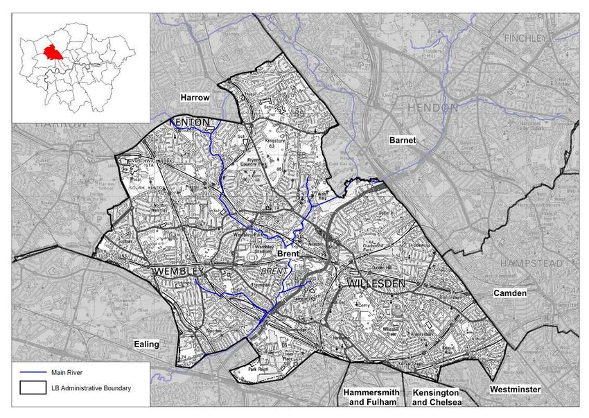
Foreword

1.0     Executive Summary

2.0     Introduction
2.1     Why is a Strategy Needed?
2.2     Who is the Strategy aimed at?
2.3     Benefits of a Flood Risk Strategy?
2.4     Legislative Context
2.5     Corporate Plans and Priorities
2.6     Objectives
2.7     Stakeholders
2.8     Climate Change and Flood Risk

3.0     Flood Risk in Brent
3.1     History
3.2     Brent Geography
3.3     Sources of flood risks
3.3.1   Surface Water Flooding
3.3.2   Sewer Flooding
3.3.3   River (fluvial) Flooding
3.3.4   Groundwater Flooding
3.3.5   Reservoir, Dam Or Canal Breach Or Failure
3.4     Getting A Better Understanding of Flood Risk
3.4.1   Modelling Surface Water Flood Risk
3.4.2   Flood Investigation Reports
3.5     Flood Risk Overview for Brent
3.6     Future Flood Risk

4.0     Management of Flood Risk
4.1     Investigating Flooding Incidents
4.2     Recording And Maintaining Assets
4.2.1   Asset Register And Record
4.2.2   Maintaining Assets
4.2.3   Designation Of Assets
4.3     Responding to Flood Incidents
4.3.1   Response To A Major Flooding Incident
4.3.2   Recovery After A Flood Incident
4.4     Delivering Flood Risk Alleviation Schemes
4.4.1   Defra Grant
4.4.2   Flood Defence Grant in Aid (FDGiA)
4.4.3   Scheme Prioritisation
4.4.4   Maintenance
4.5     Approving New Developments
4.5.1   Planning Policy
4.5.2   Strategic Flood Risk Assessment
4.5.3   SuDS (Sustainable Drainage Systems)
4.6     Partnership Working
4.6.1   North West London Flood Risk Management Group
4.6.2   Flood Risk Management Group
4.6.3   Regional Meetings

2|Page
4.7   Communicating With the Public About Flood Risk
4.8   Regulation of Ordinary Watercourses

5.0 Flood Risk Management Action Plan

6.0   Scrutiny and Review
6.1   Overview and Scrutiny
6.2   Flood Documents Review
6.3   Review of Action Plan

Appendices

A     Glossary

B     Contact Details
B1    Brent Council
B2    The Environment Agency
B3    Thames Water
B4    Affinity Water

C     Guide to Relevant Legislation
C1    Flood and Water Management Act 2010
C2    The Flood Risk Regulations 2009
C3    The Climate Change Act 2008
C4    The Civil Contingencies Act 2004
C5    The Strategic Environmental Assessment (SEA) Directive 2001
C6    The Land Drainage Act 1991
C7    The Water Framework Directive 2000
C8    Reservoirs Act 1975
C9    The Water Industry Act 1991
C10   The Highways Act 1980

D     Guide to Relevant Documents
      National documents
D1    National Strategy for Flood and Coastal Erosion Management
D2    The UK Climate Change Risk Assessment
D3     National Planning Policy Framework
      Regional Documents
D4    Managing risks and increasing resilience: The Mayor’s climate change
      adaptation strategy
D5     London Strategic Flood Framework
      Local documents
D6    Brent Strategic Flood Risk Assessment
D7    Preliminary Flood Risk Assessment
D8     Surface Water Management Plan
D9     Local Development Framework

E     Roles and Responsibilities
E1    Risk Management Authorities and Other Interested Parties
E2    London Borough of Brent

3|Page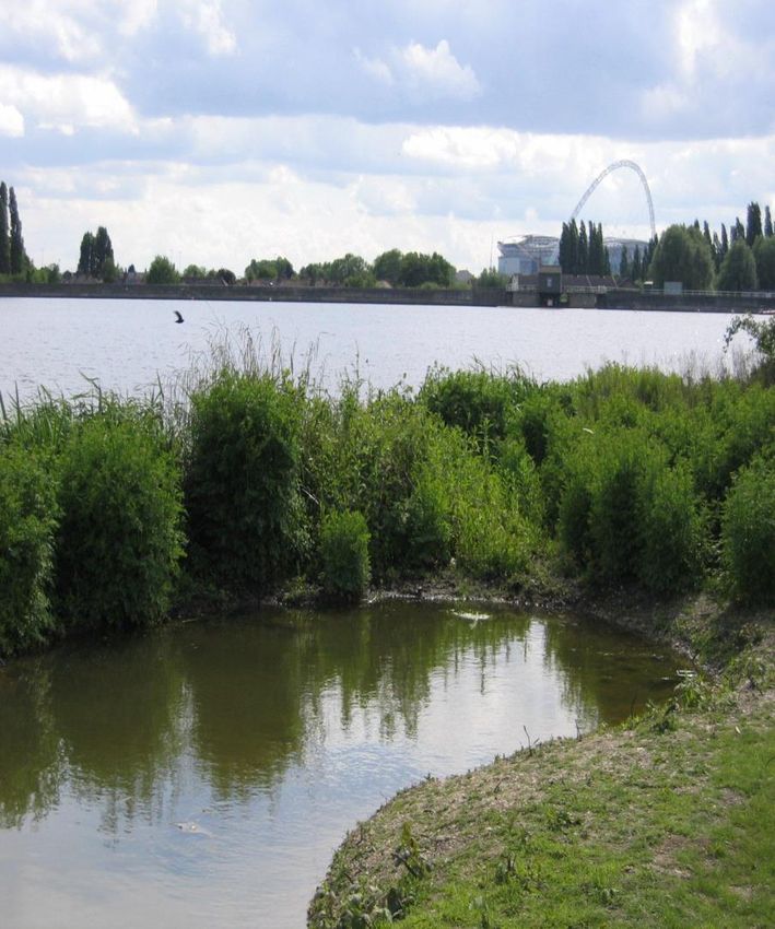
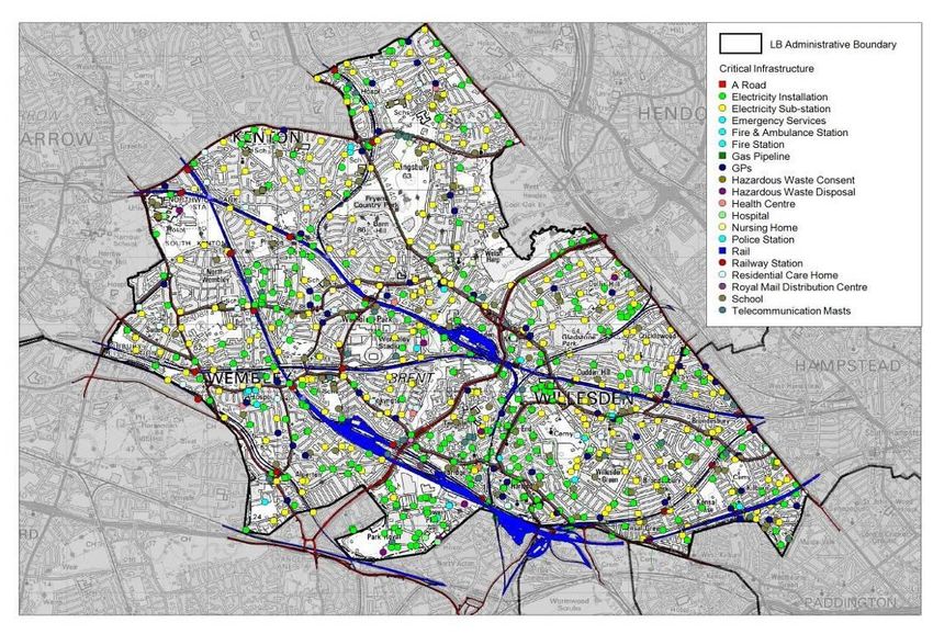
E3    Thames Water
E4    Environment Agency
E5    Transport for London
E6    Residents and Businesses
E7    The Greater London Authority
E8    Canal & River Trust
E9    Network Rail
E10   Neighbouring London Boroughs
E11   Summary of Responsibilities

F     Significant Infrastructure

G     Flood Risk Management Action Plan

4|Page
Foreword

Brent was fortunate to avoid the serious floods elsewhere in the country of 2007 and
2012, which caused so much damage and disruption for those affected. However
Brent did suffer floods in 2007 and 2010 though much of this occurred on the highway,
open spaces and gardens

The probability of such events happening again is only likely to grow as climate change
increases the frequency of extreme weather. While Brent will not see flooding as
regularly as other parts of the country, when it does happen the impact could be
serious due to densely populated nature of the borough.

Flooding can have major economic and social impacts, with people unable to return
to their homes and suffering stress as a result. For this reason reducing the long-term
risk of flooding is not only a sensible investment but also an important task, not just for
the Council but for everyone. It’s not something that any one organisation can do on
its own, because it needs co-operation between public agencies, businesses and
households.

This strategy highlights both the good work we already do to manage flood risk and
the steps we are looking to take. This document is a first step in explaining how the
various organisations plan to work together and who is responsible for what. Under
the legislation, the strategy has to explain what is being done to manage ‘local flood
risk’, for example flooding from groundwater, ordinary watercourses and surface
water. It also provides a unique opportunity to provide information on all sources of
flooding and to discuss the links between them.

It would not be possible to stop all flooding, even with unlimited funding. The strategy
aims to identify priorities representing the best way to manage the risk. Taking
effective steps to reduce flood risk, especially at a time of limited funds, requires an
evidence-based assessment to ensure that efforts and resources are appropriately
focused. Practical steps can be taken to reduce both the likelihood of severe rainfall
leading to flooding and also the impact of any flooding that does occur.

While flooding hopefully never will be something that is constantly on the mind of
residents, this strategy seeks to ensure that if and when it does happen, we are as
prepared as we reasonably can be.

                Councillor Eleanor Southwood, Lead Member for Environment

5|Page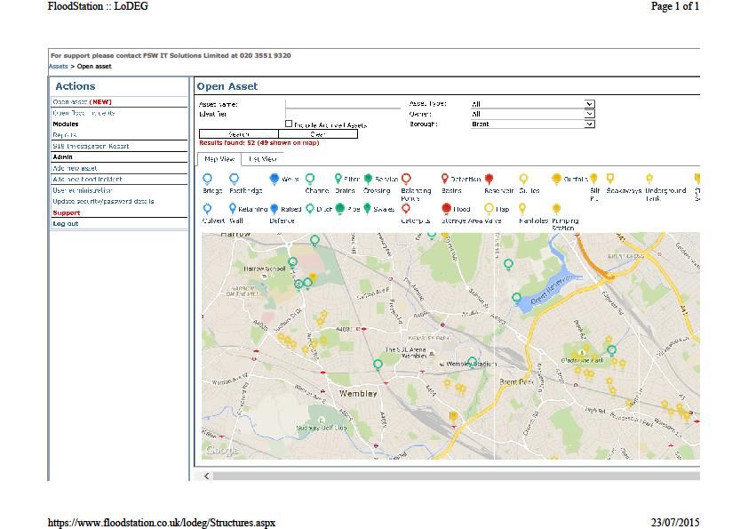
1.0   Executive Summary

      Following extensive flooding in 2007, the Government gave powers and
      responsibilities to local authorities enabling them to manage flood risk more
      effectively. The Flood Risk Regulations 2009 and the Flood and Water
      Management Act 2010, have increased the statutory responsibilities of unitary
      authorities such Brent Council, which has a new role as the Lead Local Flood
      Authority (LLFA) for the borough.

      The Flood Risk Regulations 2009 introduced duties onto Local Lead Flood
      Authorities (LLFAs) to prepare preliminary assessment reports, to identify Flood
      Risk Areas and to prepare a Flood risk Strategy. The Flood and Water
      Management Act 2010 aims to provide better, more comprehensive
      management of flood risk for people, homes and businesses. It identifies “risk
      management authorities”; bodies with an interest in flood risk management. The
      Act outlines the responsibility of the lead local flood authority to “develop,
      maintain, apply and monitor” a strategy for local flood risk management

      This strategy builds on the work already carried out in the Preliminary Flood
      Risk Assessment and Surface Water Management Plans, and details what
      actions the Council and other key stakeholders are taking to manage flood risk
      in Brent. The Strategy has five objectives:

      Improving the understanding of flooding risks In Brent
      Reducing the risk of flooding for people and businesses in Brent.
      Providing clear information on the roles and responsibilities of everyone
      involved in flood risk management in Brent
      Ensuring that emergency plans and responses to flood incidents in Brent are
      effective.
      To take a sustainable and holistic approach to flood management, seeking to
      deliver wider environmental and social benefits

      Improving the Understanding of Flooding Risks in Brent

      The Strategy sets out the flood risk to Brent, by discussing the flooding history,
      the geography of Brent, likely sources of floods and the overall risk of flooding
      for Brent.

      From the historical incidence of flooding, Brent has a low to moderate flood risk.
      The key flood risk to Brent is from surface water flooding. Surface water flooding
      occurs when the volume and intensity of a rainfall event exceeds the capacity
      of the drainage system, the responsibility for which lies with Thames Water.
      Brent also has a small risk of groundwater flooding which occurs when the water
      table rises to ground level and inundates low lying areas, though more work
      may be required to understand this. If there was a breach in the Welsh Harp
      Reservoir, the effects would be severe; however the risk of this happening is
      low. Responsibility for maintaining the Welsh Harp Reservoir lies with the
      Canals & River Trust. Brent is at no risk of flooding from the sea. The
      responsibility for risk of flooding from rivers lies with the Environment Agency.

6|Page
Getting a better understanding of flood risk will involve more studies modelling
the risk posed by surface water, and from information gathered by
investigations into flooding events.
Reducing the Risk of Flooding for People and Businesses in Brent
The strategy details what is already being done towards managing the flood risk
in Brent; including systems set up to investigate Flooding Incidents and the
register of flood risk assets - all structures or physical features that have an
effect on flood risk in Brent. If a rainfall event is severe enough, maintenance
alone will not stop flooding however maintaining existing assets is important in
alleviating the effects of flooding.
The Strategy includes a summary of the actions that Brent Council and the risk
management authorities in Brent will be undertaking to deliver the objectives of
the Strategy (Appendix G).
Providing clear information on the roles and responsibilities of everyone
involved in flood risk management in Brent
This Flood Risk Management Strategy heralds a more coordinated approach to
work in this important area. The strategy will draw together the work of other
important risk management authorities within the borough, such as water
companies and the Environment Agency. This document is a first step in
explaining how all the relevant organisations plan to work together, and who is
responsible for what.
Communicating with the Public about Flood Risk is important. Flood risk is an
emotive issue and explaining the risk to residents and businesses has to be
done appropriately. The key messages are:
Flooding is rare in Brent but when it does occur the impact could be severe and
it is important that everybody is prepared for it.
It is important that we increase our knowledge of where there is a risk of flooding
so that we can look to reduce that risk. Without this knowledge we cannot act.
It is important to report flood incidents because it adds to our knowledge on
areas at risk and frequency of incidents. This information informs how activities
are prioritised.
We can never be sure down to the level of individual properties where will be
affected by flooding.
The council has a programme of work to improve flood risk where practical
affordable solutions can be found.
Publically consulting on this strategy will be first step in engaging with residents
about flood risk.
Ensuring that emergency plans and responses to flood incidents in Brent
are effective
Flooding comes in a variety of forms with varying levels of seriousness ranging
from ponding, to disruptive flooding and then to damaging or dangerous
flooding. The strategy sets out the Council’s response in each case; preparation
for responding to “damaging or dangerous flooding” is part of ‘emergency
planning’. Emergency planning is the general term for the work that the
7|Page
government, the emergency services (i.e. fire and rescue, police and
   ambulance services), the health services and the Council does in preparing
   plans and procedures for dealing with any emergency that might affect large
   numbers of people. It has two main elements: response and recovery.

   To take a sustainable and holistic approach to flood management,
   seeking to deliver wider environmental and social benefits
   Flood risk management is an environmental activity and the strategy needs to
   support both local and national plans for sustainable development i.e.
   development which recognises the interlinking of social, economic and
   environmental needs and ensure that it can satisfy the needs of today while
   making sure that future generations can also look forward to the same quality
   of life.
   It does this by considering key national plans such as the Water Framework
   Directive and the Strategic Environment Assessment (SEA) directive, as well
   as local plans such as Brent’s planning framework.

8|Page
2.0 Introduction
2.1 Why is a Strategy Needed?
The Flood and Water Management Act, 2010, gave the Council strategic
responsibility for managing flood risk within Brent. This Flood Risk Management
Strategy (FRMS) explains how we and other stakeholders will manage flood
risk. The strategy:
Identifies the likelihood of flood risk in the borough
Outlines which stakeholders are responsible for different types of flooding to
ensure a common understanding of roles, responsibilities and priorities within
the borough.
Explains how stakeholders are working together to reduce flood risk
Provides an overview of the ongoing flood risk management work underway
across Brent.
The work identified in this strategy will help to reduce the risk of flooding but
cannot stop flooding occurring. All stakeholders will work to decrease both the
probability and the impact of flooding but it may still happen. This is why it is
important that all residents, businesses and other institutions are aware of their
responsibilities. Information about roles and responsibilities can be found in
Appendix E
2.2 Who is the strategy aimed at?
The strategy is a source of information for all those individuals, communities
and businesses which may be prone to flood risk. It is also of relevance to
authorities with flood risk management responsibilities, and other partners, to
ensure there is a common understanding of roles and responsibilities and
priorities within Brent.
2.3 Benefits of a Flood Risk Strategy
Improving the understanding of the risks of flooding from for example surface
runoff, groundwater and ordinary watercourses in Brent.
Reducing the risk of flooding for people and businesses in Brent.
Ensuring that development in Brent takes account of flood risk issues and plans
to effectively manage any impacts.
Providing clear information and guidance on the role of the public sector, private
sector and individuals in flood risk management, how those roles will be
delivered and how authorities will work together to manage flood risk.
Ensuring that emergency plans and responses to flood incidents in Brent are
effective and that communities understand the risks and their role in an
emergency.
2.4 Legislative Context
Sir Michael Pitt undertook a review of the serious flooding that occurred across
England in the summer of 2007. Nationally its effects were significant. Of
particular importance was the high proportion of flooding that came from surface
water runoff, rather than rivers.
The Pitt Review (June 2008) made 92 recommendations intended to change
the way that local flood risk was managed. Many of these recommendations
9|Pagewere based on upper tier local authorities, such as Brent Council, playing a
greater role in the management of local flood risk as the Local Lead Flood
Authority (LLFA). The roles and responsibilities of Brent Council and our
partners in relation to flood risk management are principally defined by two key
pieces of legislation:
The Flood Risk Regulations 2009
This introduced the following duties onto Local Lead Flood Authorities ( LLFAs)
;
the duty to prepare preliminary assessment reports;
the duty to identify Flood Risk Areas and
the duty to prepare a Flood Risk Strategy
See also Appendix C2 for further information on these Regulations.
Flood and Water Management Act 2010
The Flood and Water Management Act aims to provide better, more
comprehensive management of flood risk for people, homes and businesses.
The Act identifies risk management authorities, which are bodies with an
interest in flood risk management.
Brent Council takes on the role of Lead Local Flood Authority, and has the ‘lead’
role in managing local flood risk from surface water, groundwater and ordinary
watercourses across Brent. The Act outlines the responsibility of the lead local
flood authority to “develop, maintain, apply and monitor” a strategy for local
flood risk management. See also Appendix C3 for further information on this
Legislation.
2.5 Corporate Plans and Priorities
The Brent Borough plan 2015-19 was agreed at meeting of full council in March
2015. The plan aims to deliver “Better lives, Better place and Better Locally”
Better lives means:
making sure that local people have the best possible life chances, regardless
of their starting position
supporting local enterprise, generating jobs for local people, helping people into
work and promoting fair pay
making sure that our schools are amongst the best and that our children and
young people achieve to their potential
enabling people to live healthier lives and reducing health inequalities
supporting vulnerable people and families when they need it.
Better place means
making sure that Brent is an attractive place to live, with a pleasant
environment, clean streets, well-cared for parks and green spaces
continuing to reduce crime, especially violent crime, and making people feel
safer
increasing the supply of affordable, good quality housing
supporting good quality, accessible arts and leisure facilities.
Better locally means
10 | P a g ebuilding resilience and promoting citizenship, fairness and responsibility
amongst local people and strengthening the sense of community amongst the
people who live and work here
promoting cohesion and integration amongst our communities
making sure that everyone has a fair say in the way that services are delivered,
that they are listened to and taken seriously
making sure that inequalities in the quality of life in different parts of the borough
are tackled by a stronger focus on local needs
building partnership - between local service providers and between local
services and residents - to find new ways of providing services that are more
finely tailored to individual, community and local needs.
Implementing the objectives of the Flood Risk Management Strategy aligns with the
“Better Place” aspect of the Brent Borough plan.
2.6 Objectives
The objectives for the Brent Flood Risk Management Strategy (FRMS) reflect
the requirements of the Flood and Water Management Act 2010 and the
National Flood and Coastal Erosion Risk Management Strategy, 2011.The
objectives of the Strategy are as follows:
Improving the understanding of the risks of flooding in Brent
Reducing the risk of flooding for people and businesses in Brent.
Providing clear information on the roles and responsibilities of everyone
involved in flood risk management in Brent
Ensuring that emergency plans and responses to flood incidents in Brent are
effective.
To take a sustainable and holistic approach to flood management, seeking to
deliver wider environmental and social benefits.
Flooding is a natural event that will sometimes occur despite all efforts to
prevent it. However, through the strategy we will coordinate our services so
that flood risk is reduced and the aftermath of flood incidents is minimised. The
strategy provides a real opportunity for us to work together as no single
organisation can effectively manage flood risk alone and co-operation is
needed from public agencies, the private sector and households. Effective
flood risk management can reduce long-term flood damage costs and is a
worthwhile investment for both the public and private sector.
2.7 Stakeholders
The Flood and Water Management Act 2010 identifies the Council, the
Environment Agency and Thames Water as the risk management authorities
(RMAs) for the area with new responsibilities. Additionally, the following
stakeholders have been identified:
Residents and businesses
Greater London Authority/Transport for London
City of London Corporation
Neighbouring London boroughs
Network Rail
Canal & River Trust
11 | P a g eAppendix E gives an overview of stakeholders’ responsibilities.
Case study – working with stakeholders on project appraisal
2.8 Climate Change and Flood Risk
Climate change is likely to continue for many decades to come. The Brent
Climate Change Adaptation Strategy identifies the expected changes that the
borough will face, which include an increasing magnitude and frequency of
intense rainfall events.
Flooding is a natural process and the speed of inundation and duration varies
greatly. With climate change, however, the frequency, velocity, depth, patterns
and severity of flooding are forecast to increase causing flash flooding, and
heavier average winter precipitation that will put us at greater risk of flooding.
The Brent Climate Change Adaptation Strategy is based on the UK Climate
Projections 2009 (UKCP09). These scenarios are generated based on
probability. No climate model can give a single definite answer to what the
future will look like, however, under the high emissions scenario (which looks
the most likely) peak rainfall is likely to increase significantly.
3.0 Flood Risk in Brent
3.1 History
Brent is very fortunate that we have not experienced major flooding incidents in
last 20 years. The most recent floods were in 2007 and 2010 and much of this
occurred on the highway, open spaces and gardens. The key flood risk to Brent
is from surface water flooding which occurs when the volume and intensity of a
rainfall event exceeds the capacity of the drainage system. (which is the
responsibility of Thames Water) Flooding from main rivers and ordinary
watercourses has been minimal. The main rivers in the borough are maintained
by Environment Agency and we will work with them to ensure that they are
inspected and maintained regularly.
3.2 Brent Geography
The Brent covers approximately 4,310 hectares of North West London (Figure
1.1). This includes the urban areas of Brondesbury Park, Kensal Rise, Kenton,
Kilburn, Kingsbury, Sudbury, Wembley and Willesden.
12 | P a g eFigure 3.1
Brent is bordered by the London Boroughs of Barnet, Camden, Westminster,
Kensington and Chelsea, Hammersmith and Fulham, Ealing and Harrow. Within
the borough there are several areas of high ground which range from 75–65 m
Above Ordnance Datum (AOD). These ridges of high ground divide the borough
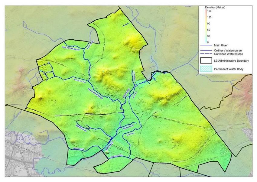
up into two main river catchments. The River Brent intersects the borough
running from the north-east to south-west and the Wealdstone Brook runs
through the London Borough of Harrow to the north of the LBB down to its
confluence with the River Brent near the centre of the borough (Figure 3.1).
There are several smaller watercourses which form tributaries of the River Brent:
Mitchell Brook and Wembley Brook. The Grand Union Canal runs along the
south-western boundary of the LBB with a connecting feeder channel running
from the Welsh Harp reservoir to the north-east of the borough.
13 | P a g eFigure 3.2
The lower lying areas of the borough in the river valleys range from 37–22 m
AOD along the River Brent and to 40–33 m AOD along Wealdstone Brook.
Approximately 93% (40km2) of the LBB is urbanised. There are small pockets of
open land with the largest being Fryent Country Park to the north east of the
borough.
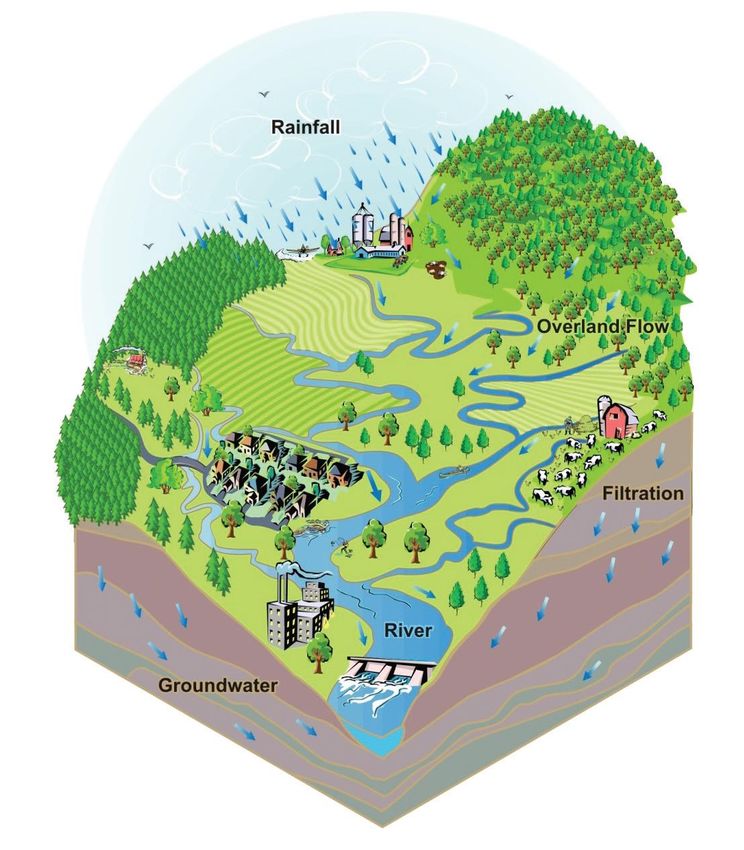
3.3 Sources of flood risk
This section describes the various forms of flooding that can be experienced.
Whilst the responsibilities for flooding are divided between different risk
management authorities (see Appendix E), there is interaction between the
different systems within a catchment that can lead to flooding. A rainstorm may
bring rainfall to a catchment, which will soak into the soil and eventually may
replenish groundwater. If the soil is saturated or the land is covered by
impermeable surfaces, it will flow to local watercourses through land drains or
sewers. The local watercourses will flow to the rivers, collecting rain from more
drains and sewers on the way. The river will flow towards the sea, collecting
water from more local watercourses on the way or from groundwater if the water
table is high enough. A diagram of a catchment is shown in Figure 3.3.
14 | P a g eFigure 3.3 - A Catchment Area (US EPA)
There are a number of sources of potential flooding:
3.3.1 Surface water flooding
Surface water flooding occurs when heavy rainfall exceeds the capacity of the
ground and local drainage network to absorb it. This sort of flooding is typically
caused by short, intense rainfall.
Surface water flooding is most problematic when catchments are already
saturated or frozen, and in urban areas where a substantial proportion of the land
surface is impermeable. This is due to the presence of houses and other
buildings, roads and pavements
Flooding associated with the highway network is the most common form of
localised flooding and occurs during or immediately after heavy storms. It is most
commonly caused by blocked gullies or the surcharging of outfall pipes, which
take the water away from roads with tarmac-type surfaces.
The Risk to Brent from this form of flooding is covered in Section 3.5. To improve
our understanding of surface water flood risks (and other local sources of
flooding) surface water management plans have been undertaken in areas
identified as high risk in the Preliminary Flood Risk Assessment. Surface Water
15 | P a g eManagement Plans are studies into the local flood risks of an area which tell us
what risks the area faces and provide a plan for managing any significant risks.
The Preliminary Flood Risk Assessment and Surface Water Management Plans
will be published along with this Strategy in 2016.
3.3.2 Sewer flooding
Sewers are designed to cope with the majority of storms, but occasionally storms
are so heavy that they overwhelm the system. This type of flooding is particularly
severe when a combined sewer (a sewer that carries both surface water and foul
water) floods as it causes effluent to be discharged that can pose a risk to health
and the environment. Sewer flooding is the responsibility of the sewerage
undertaker.
The following factors are increasing the risk of a sewer flooding:
• population growth - leading to increased housing and associated development
• paving over of green spaces and undeveloped land - preventing natural
infiltration and drainage
• disposal of fat, oil and grease - which harden in the sewers
• climate change - leading to more intense storms.
The risk to Brent from this form of flooding is minimal. In 2014/15, only 2
properties were affected by flooding due to inadequate capacity in the drainage
system.
3.3.3 River (fluvial) Flooding
River flooding (sometimes known as fluvial flooding) is caused when rivers do
not have its enough capacity in their natural channel to contain the water flowing
in them. A river bursting banks is usually caused by prolonged periods of heavy
rainfall. The Environment Agency is responsible for main rivers and smaller
watercourses of strategic drainage importance, which includes the rivers in
Brent.
The Flood Maps use data from modelling and past flood events to map flood
extents and can be publicised to help increase awareness of flood risk. They
are used by a range of organisations, including local authorities, insurers and
developers. Property owners can view the information on the Environment
Agency website, 'what's in your backyard?' Brent’s Flood maps will be
published along with this strategy in 2016
The Environment Agency's National Flood Risk Assessment (NaFRA) shows
the likelihood of flooding across England and Wales. It assesses the probability
of flooding from rivers and the sea. It takes account of the location, type and
condition of defences and maps the risks in three probability bands - significant,
moderate and low.
The borough has the River Brent running through it north-east to south-west
and the Wealdstone Brook runs down to its confluence with the River Brent
near the centre of the borough (Figure 3.1). There are several smaller
watercourses which form tributaries of the River Brent: Mitchell Brook and
16 | P a g eWembley Brook. The risk to Brent from this form of flooding is very low and no
reports of flooding have been received in the last few years.
3.3.4 Groundwater Flooding
Groundwater flooding generally occurs in low-lying areas, as the result of
groundwater rising above the surface of the land. The risk of groundwater
flooding is influenced by the underlying geology. There can be substantial time-
lags between persistent or heavy rainfall which leads to rising groundwater
levels, and flooding resulting from the emergence of groundwater. This is due
to the relatively slow rate at which water percolates into and moves through the
ground
The risk of groundwater flooding can be affected by development, which alters
the natural flow patterns and pathways.
At present, our understanding of the risk of groundwater flooding in Brent is
limited. Work needs to be done to assess the risk posed by groundwater
flooding and then a decision can be taken as to whether further study is
required.
3.3.5 Reservoir, Dam or Canal Breach or Failure
Although the safety record for reservoirs is excellent, if a situation did occur,
flood incidents would be instantaneous with significant movement of debris.
Reservoirs hold large volumes of water and the safe operation and
management of reservoirs to reduce flood risk is vital. In Brent there is only one
reservoir (Welsh Harp) which is the responsibility Canals and Rivers Trust.
3.4 Getting a better understanding of Flood Risk
As extreme rainfall events do not happen regularly but cause serious damage
when they do occur, we need to model the effect of such rainfall events on the
borough. This is particularly important because climate change has been
predicted to increase the likelihood of major rainfall events. However it would
be risky to rely just on modelling, so it is important that any significant flood
events are investigated fully as well.
3.4.1 Modelling Surface Water Flood Risk
High level modelling has been carried out to better understand the surface
water flood risk to the borough. This is not detailed enough to determine which
individual properties would be affected. There will always be factors that cannot
be captured on a model which will prevent models being fully accurate to a fine
level of detail.
This modelling process was begun by Drain London, the GLA programme to
improve understanding of surface water flood risk in Greater London. Drain
London helped deliver Preliminary Flood Risk Assessments (2011) and Surface
Water Management Plans (2011) for every London borough. This process
helped provide a consistent baseline across the whole London In addition to
this; Brent has undertaken work to meet its responsibilities under the Flood Risk
Regulations 2009.
17 | P a g eAs part of the work to develop the Preliminary Flood Risk Assessment, Greater
London was identified as one of the 10 major surface water flood risk zones in
England. As a result, Flood Hazard and Flood Risk Maps for Greater London
were published in June 2013
The Brent Strategic Flood Risk Assessment (SFRA) provides the results of the
latest flood risk modelling and mapping for the borough and this document is
used when Planning applications are considered. Neighbouring boroughs’
SFRAs and Local Flood Risk Management Strategies provide further evidence
of the risks elsewhere in London which may affect Brent.
At present, a drainage study is being carried out by Thames Water in order to
establish the flow characteristics and capacity in the river and drainage system.
On completion of this study, this will provide detail information on areas affected
by flooding and solutions. The study is being carried out on the behalf of North
Brent and Harrow Flood Stakeholders Group. This group comprises of
representatives from Brent, Harrow, Thames Water and Environment Agency.
3.4.2 Flood Investigation Reports
Under Section 19 of the Flood and Water Management Act, as the LLFA, the
Council has a responsibility to investigate the cause of flooding and notify the
relevant risk management authority.
(1)On becoming aware of a flood in its area, a lead local flood authority must,
to the extent that it considers it necessary or appropriate, investigate
(a) which risk management authorities have relevant flood risk management
functions, and .
(b) whether each of those risk management authorities has exercised, or is
proposing to exercise, those functions in response to the flood.
(2)Where an authority carries out an investigation under subsection (1) it must
(a) publish the results of its investigation, and .
(b) notify any relevant risk management authorities.
The decision of whether a flood event is significant and so requires investigation
(or not) is at the discretion of the LLFA. The Council will therefore carry out an
initial appraisal where internal flooding of a single residential property,
business or office premises has occurred, or where a flooding incident
impacted on an identified item of critical infrastructure (as detailed in
Appendix E.)
This initial appraisal will determine the main source of flooding and therefore
the risk management authority responsible for resolving the incident, which will
then be notified. Where the source of flooding is deemed to be the responsibility
of Brent Council i.e. flooding from ordinary watercourses, surface water or
groundwater, an investigation will be carried out.
The aim is for flood investigation reports to bring all useful information together
in one place, providing an understanding of the possible causes of flooding and
potential long-term solutions.
18 | P a g eFurther recommendations will also be made to highlight potential flood risk
management actions. Reports will seek to provide a clear and thorough
understanding of the flooding situation, but our duty to investigate does not
guarantee that problems will be solved. Decisions to take action must be taken
by the responsible parties and we cannot force other authorities into action.
However the investigations can act as a catalyst for change.
A summary of the results of the full flood investigations will be published on the
Council’s website. All S.19 flood reports will be recorded to extend the Council’s
historic incident records.
3.5 Flood Risk Overview for Brent
According to the Environment Agency‘s property count for their national Flood
Map for Surface Water (FMfSW) dataset, approximately 35,500 residential
properties and 4,400 non residential properties in Brent could be at risk of
surface water flooding of greater than 0.1m (10 cm) depth during a rainfall event
with a 1 in 200 probability of occurrence in any given year.
Furthermore, of those, 12,600 residential properties and 4,400 non-residential
properties are estimated to be at risk of flooding to a depth of greater than 0.3m
(30 cm) during the same modelled rainfall event.
3.6 Future Flood Risk
Under United Kingdom Climate Projections 2009 (UKCP09), predictions for
future rainfall in the UK up to 2080 are that there could be around three times
as many days in winter with heavy rainfall (defined as more than 25mm in a
day). It is plausible that the amount of rain in extreme storms (with a 1 in 5
probability of occurrence in any given year (20% AEP) or rarer) could increase
locally by 40%.
Within the Thames River Basin District, if emissions follow a medium future
scenario, UKCP09 projected changes by the 2050s relative to the recent past
are:
Winter precipitation increases of approximately 15% (very likely to be between
2 & 32%);
Precipitation on the wettest day in winter up by approximately 15% (very
unlikely to be more than 31%);
Relative sea level at Sheerness very likely to increase between 10 and 40cm
from 1990 levels (not including extra potential rises from polar ice sheet loss);
Peak river flows in a typical catchment likely to increase between 8 and 18%.
The risk of overloading the urban drainage system and surface water flooding
in the Borough is therefore likely to increase into the future unless steps are
taken to manage and mitigate this form of flooding.
19 | P a g e4.0 Management of Flood Risk
This section explains how flood risk management will be operated in Brent
through the following ongoing activities:
Investigating Flooding Incidents
Recording And Maintaining Assets
Responding to Flood Incidents
Funding And Delivering Flood Risk Alleviation Schemes
Approving New Developments
Partnership Working
Communicating With The Public About Flood Risk
Regulation of Ordinary Watercourses
4.1 Investigating Flooding Incidents
Investigate all flooding complaints, keep records of flooding, identifying the
cause and arrange remedial works where deemed necessary as detailed in
Section 3.4.2.
4.2 Recording And Maintaining Assets
4.2.1 Asset Register and Record
As the LLFA, the Brent Council is obliged to establish and maintain a register
“Flood Risk Assets,” which are all structures or physical features that have an
effect on flood risk in an area. These include everything from the Welsh Harp
Reservoir to highways gullies. DEFRA has provided full guidance on what
constitutes a flood risk asset, which can be found in Appendix D.
This must be available for inspection at all reasonable times. Brent Council must
also produce a Record detailing the ownership and state of repair of each asset,
which is not publically accessible. Brent uses the “Floodstation” asset register
software to record all its Flood risk assets
The recording and maintenance of flood risk assets is an important element of
flood risk management because well maintained assets, such as drainage
systems, ensure that water flows are directed away from buildings and
important local infrastructure
The LLFA must determine the criteria for deeming an asset as having a
significant effect. In Brent, an asset is deemed to be significant if it is:
Features and structures that have a significant effect on local flood risk
will be ones which, if compromised in any way, may contribute to a risk
of a significant flood event (as defined in section 3.4.2)
The register stating the key assets in the borough will be published on our
website in 2016 and will be updated annually with new assets and changes in
ownership recorded. The record will be shared with all the organisations which
have contributed data to it.
20 | P a g eFigure 4.1 – Floodstation asset register software
4.2.2 Maintaining Assets
Well maintained assets cannot prevent flooding happening but they can lessen
its impact and probability. All asset owners are responsible for maintaining their
own assets. Council assets are maintained by a variety of services and each
service is responsible for maintaining and checking their condition (see also
section 5.4.4).
4.2.3 Designation of Assets
The Council and the Environment Agency are the ‘designating’ authorities of
assets. If an asset becomes designated, its owner cannot alter or remove it
without first consulting the designating authority. The aim of designating flood
risk assets is to safeguard them against unchecked works which could increase
flood risk in the area. It is not possible to designate assets owned by a risk
management authority so Thames Water assets cannot be designated although
this does not diminish their responsibilities for maintaining them, as asset
owners. A process for designating assets will be designed in partnership with
neighbouring authorities to ensure that there is consistency across the different
boroughs.
4.3 Responding To Flood Incidents
For the sake of clarity, flood incidents will be divided into the following types:
• Ponding - This is a common occurrence after heavy rain and is characterised
by puddles. The water is neither causing serious disruption nor threatening
buildings or critical infrastructure. Persistent ponding can be investigated and
resolved as a maintenance activity; localised severe ponding can be dealt with
through the council’s highway Emergency Call Out function.
• Disruptive flooding - This is flooding which is making it harder for people to
carry on as normal by blocking roads and pathways or forcing the cordoning off
21 | P a g eof parks and other open spaces. It is not threatening buildings or critical
infrastructure.
• Damaging or Dangerous flooding - a major flooding incident - This is flooding
that enters buildings or critical infrastructure causing damage or is flowing at
such rates as to cause serious danger to people.
For Actions to take when the above types of flooding occurs, please refer to the
councils website https://brent.gov.uk/emergencies/severe-weather/flooding
Preparation for responding to “damaging or dangerous flooding” is part of
‘emergency planning’. Emergency planning is the general term for the work that
the government, the emergency services (i.e. fire and rescue, police and
ambulance services), the health services and the Council does in preparing
plans and procedures for dealing with any emergency that might affect large
numbers of people. It has two main elements: response and recovery.
4.3.1 Response to a Major Flooding Incident
The Councils’ Emergency Planning Team will take action according to the
information set out on the Council’s website
https://brent.gov.uk/emergencies
The Met Office’s national severe weather warning service provides warnings of
severe or hazardous weather to the public. These warnings are available on the
Met Office website
http://www.metoffice.gov.uk/public/weather/warnings
The warnings are for broad areas and there is very little warning time for how it
will affect specific neighbourhoods. Due to the uncertainty and very short
timeframe for warnings there is very little the Council can do other than to be
ready to respond to reports of flooding and react where flooding is taking place.
In a major rainfall event, the ability of local emergency services to be able to
help everybody is limited and will focus on preservation of life. In major flood
events, we will look to help those who are vulnerable and cannot help
themselves through family and friends by organising short term temporary
shelter in respite centres.
The Environment Agency provides an online flood warning service that can be
viewed at http://apps.environment-agency.gov.uk/flood/31618.aspx. This
service provides 3 day warnings, river levels and a live flood warning map. Brent
Council Emergency Planners have also published a Multi Agency Flood Plan
covering flood events and are able to provide assistance during and after a
severe flood event including recovery
4.3.2 Recovery after a Flood Incident
22 | P a g eRecovery from an incident will begin as soon as possible. As the floodwater
recedes, the emergency response may still be on-going while the recovery
phase begins. If it is a minor flood, recovery activities such as cleaning of streets
will usually form part of normal operations without special arrangements. If it is
a severe flood affecting many people and properties, it will require a co-
ordinated response which will determine local strategies in recovery, prioritising
needs and allocating resources appropriately so that the community returns to
normality as soon as possible. The Council would take a lead role in managing
the recovery process.
4.4 Delivering Flood Risk Alleviation Schemes
There is no obligation on any organisation to deliver flood defence or mitigation
schemes to residents or businesses that are at risk of flooding. New
developments should be designed to be resilient to major flood events and will
not receive any government support for flood mitigation schemes in the future.
For existing homes and offices, there is limited central government funding
available to support flood risk mitigation projects when there is a strong benefit
to cost ratio.
5.4.1 Defra Grant
In order to support the delivery of the Flood and Water Management Act 2010,
Defra provides a grant to lead local flood authorities for the duration of the
current spending review period. Brent Council received £136,000 in 2015/16
and is likely to receive similar amount for future years.
This money will be used by Brent to fund the new responsibilities we have under
the Act. This includes staff costs to undertake these new responsibilities and
financing investigations into local flooding. We already work in partnership with
other neighbouring lead local flood authorities and Environment Agency to
identify flooding areas so that bids can be made for funding.
5.4.2 Flood Defence Grant in Aid (FDGiA)
Flood defences and coastal erosion risk management schemes are funded
from a government grant called Flood Defence Grant in Aid (grant in aid) which
is administered by the Environment Agency on behalf of Defra. Until recently
schemes would receive full grant in aid funding if they met a certain cost-benefit
ratio, while schemes that did not achieve this ratio would receive no grant.
Under this mechanism many schemes never achieved the required cost-benefit
ratio and could never be delivered.
Defra has changed the way grant in aid will work from April 2012. The new
partnership funding approach determines what proportion of the cost of a
scheme can be funded by grant in aid. Some schemes will be fully funded,
others only partly funded, according to how much public benefit they will give,
for example by reducing flood risk to homes and vital infrastructure, (e.g. power
stations and water treatment works). Any shortfall in the amount of grant in aid
required to construct the scheme will need to be found from elsewhere. This
could be from local levy funding from the local levy, from local businesses or
other parties who will benefit from the scheme.
23 | P a g eThis change provides an opportunity for local communities to have more
influence on how flood defences are delivered in their communities. However it
also means that local communities may have to find funds to contribute to flood
risk management schemes.
We monitor and review flooding incidents to identify any flooding areas that
require flood alleviation schemes and bid for funding when appropriate.
4.4.3 Scheme Prioritisation
It is not possible to prevent all flooding, and with limited resources and funding
flood risk management work will need to be prioritised.
Schemes of local importance
These schemes are to manage flood risk that is more localised and require
works that are small, therefore they may not be eligible for grant in aid these,
but they are still locally important.
Prioritisation for funding for drainage schemes is covered in Brent’s Highway
Asset Management Plan which was adopted by the Council on 17th February
2014. The full document can be found here:
www.brent.gov.uk/media/9244640/Brent-HAMP-2014.pdf
The scheme programme for carriageways footways and drainage is drawn up
and then approved by the Lead Member for Environment on an annual basis,
in the early part of the calendar year, so that an quick start can be made on the
scheme programme early in the new financial year.
4.4.4 Maintenance
Brent Council is are responsible for maintaining over 24,500 gullies covering all
adopted roads except the A406 North Circular Road, which is maintained by
Transport for London.
Gully cleansing is carried out by through the LoHAC (London Highways Alliance
Contract) by contractor ConwayAecom on cyclical basis with all gullies cleaned
at least once every 18 months and the most important gullies being cleaned
twice a year. The frequency with which gullies are cleansed is based on best
practice guidance and historic data which has identified the gullies in known
flooding areas or where the impact of a blocked gully would have a serious
impact, for instance at the bottom of a hill.
The gully cleansing programme is closely monitored to make sure it stays on
target, and audits are carried out to ensure that gullies have been cleaned.
Any faults found during cleansing – for instance a collapsed pipe or a jammed
gully grate - are reported by the contractor and the council issues works orders
to rectify faults, according to priorities and available budget. More serious
problems may require further investigation, such as a CCTV survey of the pipe
network, before the problem can be identified and resolved.
24 | P a g eIn this way the drainage network is maintained, so that it can work as effectively
as it can in draining away highway surface water.
4.5 Approving New Developments
It is vital for good flood risk management that new developments are safe from
flood risk and do not increase it elsewhere. Planning policy is led by the Council
in its role as the local planning authority. The Environment Agency and Thames
Water advise planning authorities on very large sites.
We will be working closely with developers, to seek funding opportunities that
will combine flood storage and SuDS objectives and open space improvements
that will provide benefits to habitat, biodiversity, water quality and accessibility
for education and healthier lifestyles by encouraging more outdoor activity.
4.5.1 Planning Policy
The Local Development Framework in Brent, states that we will require all
development to take measures to minimise the effects of, and adapt to, climate
change and encourage all development to meet the highest feasible
environmental standards that are financially viable during construction and
occupation by ensuring buildings and spaces are designed to cope with, and
minimise the effects of, climate change.
Over the years, the increase in buildings and development in Brent has covered
previously permeable ground which means increased rainwater that will run off
the surface down drains and into the sewers
We will require major developments or development that increases the amount
of impermeable surfacing to adequately manage the increases in surface water
or sewage discharge.
Development will also be required to take account of known sewer flooding
problems by including appropriate mitigation measures to avoid increased
drainage problems and flood risk downstream. Where possible, they should
look to reduce the flood risk.
In particular, developments in areas which have been identified as being at risk
of surface water flooding must be designed to cope with storm events with a
1% chance of happening in any one year/ 1 in 100 year return period (including
30% allowance for climate change). This is in order to limit the flooding of, and
damage to, property.
It is also important to address climate change which has resulted in wetter
winters and heavier showers in the summer months which is predicted to get
worse over the coming decades. This will put additional pressure on an ageing
sewer system. Air Pollution can also contribute to floods. A 10 year study
published in Nature Geoscience by Zhanqing Li found that air pollution,
impedes gentle rains while exacerbating severe storms.
http://www.nature.com/ngeo/journal/v4/n12/full/ngeo1313.html This shows the
need for the council to continue to help reduce the sulphur, nitrogen and
25 | P a g ehydrocarbon emissions within Brent through its policies to improve transport
sustainably, reduce congestion and hence pollution.
Regarding Sustainable design and construction: the way development is
delivered in the borough will have a significant effect on environmental, social
and economic outcomes. The core strategy should promote the principles of
sustainable design and construction as set out in the Code for Sustainable
Homes (DCLG 2006), and the Decent Homes and Decent Communities
Programme (DCLG 2006), as well as the London Plan Supplementary Planning
Guidance on Sustainable Design and Construction (GLA 2006). The core
strategy should also promote Brent Supplementary Planning Guidance 19:
Sustainable Design, Construction and Pollution Control.
4.5.2 Strategic Flood Risk Assessment
As a planning authority, the Council is required to produce a Strategic Flood
Risk Assessment (SFRA) to provide evidence for the Local Development
Framework. We produced a joint SFRA with the other seven north London
boroughs in the North London Waste Partnership. This was published in August
2008.
4.5.3 SuDS (Sustainable Drainage Systems)
Sustainable urban drainage systems (SuDS) will now be a planning
requirement for developments of ten dwellings or more and equivalent non-
residential schemes from April 2015 unless developers can demonstrate that
SuDS would be inappropriate. Schedule 3 of the Flood & Water Management
Act (FWMA) and the approval of SuDS by a SuDS Approving Body (SAB) is
now replaced by changes to the National Planning Policy Framework (NPPF).
The Government laid a Statutory Instrument making LLFAs a Statutory
Consultee by adding the consultation requirements to Schedule 4 of the
Development Management Procedure Order from 15 April 2015.
This confirms that in considering planning applications, local planning
authorities should consult the relevant Lead Local Flood Authority on the
management of surface water; satisfy themselves that the proposed minimum
standards of operation are appropriate and ensure through the use of planning
conditions or planning obligations that there are clear arrangements in place for
on-going maintenance over the lifetime of the development.
The changes will strengthen existing planning policy to ensure that sustainable
drainage systems will be provided in new major developments where
appropriate.
On 24 March 2015, the Government laid a statutory instrument making the Lead
Local Flood Authority a statutory consultee by adding the consultation
requirement to Schedule 4 of the Development Management Procedure Order.
This came into effect from 15 April 2015.
26 | P a g eGovernment has considered the new burden, in consultation with the Local
Government Association, of making the Lead Local Flood Authority a statutory
consultee in the planning process. The final assessment gained clearance from
the Department of Communities and Local Government and Her Majesty’s
Treasury, allowing Defra to issue contracts for funding to all 152 Lead Local
Flood Authorities on 18 March 2015.
4.6 Partnership Working
4.6.1 North West London Flood Risk Management Group.
Brent will manage flooding incidents more efficiently and promote partnership
working with other stakeholders by through the North West London Flood Risk
Management Group.
Brent is bordered by the London Boroughs of Barnet, Camden, Westminster,
Kensington and Chelsea, Hammersmith and Fulham, Ealing and Harrow. As
part of Drain London, London boroughs were divided in to 8 groups (see
Appendix E7)
The group consists of Drain London groups 1 and 2 and comprises of London
Boroughs of Barnet, Ealing, Harrow, Hillingdon, Hounslow and Brent. The
Group will provide a platform for the NW London Boroughs to assist with
delivering the requirements of the FWMA and Flood Risk Regulations in the
sub-region. This will be attended by external partners and stakeholders who
have an interest in flood risk management and the meetings are held quarterly.
5.6.2 Flood Risk Management Group
In order to manage Flood Risk Strategy more effectively, an internal Brent group
will be set up to oversee the delivery of Brent’s Flood Risk Strategy. In addition
to regular meetings, ad-hoc meetings will be held after storm events to discuss
problem encountered and lessons learned.
4.6.3 Regional Meetings
In order that Brent’s flood risk planning is co-ordinated with the rest of London,
Brent will continue to attend Regional meetings, Drain London and LoDEG
(London Drainage Engineering Group) has been established by all 33 London
Boroughs and meetings are held quarterly. Information from these meetings
will be reported back to the Brent Flood Risk Management Group.
4.7 Communicating with the Public about Flood Risk
Flood risk is an emotive issue and explaining the risk to residents and
businesses has to be done appropriately. The key messages are:
Flooding is rare in Brent but when it does occur the impact could be severe and
it is important that everybody is prepared for it
It is important that we increase our knowledge of where there is a risk of flooding
so that we can look to reduce that risk. Without this knowledge we cannot act.
It is important to report flood incidents because it adds to our knowledge on
areas at risk and frequency of incidents. This information informs how activities
are prioritised
27 | P a g e We can never be sure down to the level of individual properties where will be
affected by flooding.
The council has a programme of work to improve flood risk where practical
affordable solutions can be found.
Publically consulting on this strategy will be first step in engaging with residents
about flood risk.
We will also develop a communication plan to publish flood risk management
information on the Council’s website, enabling residents to help themselves.
4.8 Regulation of Ordinary Watercourses
The Flood and Water Management Act 2010 has transferred existing powers to
regulate the proper function of ordinary watercourses to Brent. These powers
consist of two parts:
• The enforcement obligations to maintain flow in a watercourse and repair
watercourses, bridges and other structures in a watercourse; and
• The power to give consent for structures in the watercourse and changes to the
alignment of the watercourse
The enforcement powers have been transferred from local authorities and the
consenting powers have been transferred from the Environment Agency. These
are permissive powers, not duties, Brent can choose to exercise them
It is advised that anyone considering any works in or near a watercourse contact
the relevant authority to discuss the need for consent
5.0 Flood Risk Management Action Plan
A summary of the actions that the Brent and the risk management authorities will
be undertaking over the next year and beyond to deliver the objectives of the
local strategy forms Appendix G.
6.0 Scrutiny and Review
6.1 Overview and Scrutiny
Flooding falls under the remit of the London Borough of Brent Council Cabinet
Member for Environment, who will receive the bi-annual report from the Flood
Risk Management Group. Other risk management authorities will continue to
review their own activities and plans through their governance arrangements.
6.2 Flooding Documents Review
We will review the Brent Preliminary Flood Risk Assessment, which is a key
evidence base for this strategy, in 2017. All of these actions will then be repeated
on a six yearly cycle so a new PFRA is expected in 2017, a new Flood Hazard
and Flood Risk Maps in 2019 and a new Flood Risk Management Plan in 2021.
28 | P a g eYou can also read