FOR PEOPLE WHO LOVE EARLY MAPS - MARCH 2018 NO. 152 - IMCOS
←
→
Page content transcription
If your browser does not render page correctly, please read the page content below
152
                                     International Map Collectors’ Society

      march 2018 No.152

                     For people who love early maps
Journal of the International
Map Collectors’ Society
march 2018 No.152 ISSN 0956-5728
articles
Geographia: Representations of mapmaking in the early 14
modern period
Michael Bischoff
The British Atlas, 1810: A reassessment of the town maps 25
David Smith
Mapping the Mediterranean: By the cartographers of 36
medieval Islamic societies
Cyrus Alai
regular items
A Letter from the Chairman 3
Editorial 5
New Members 5
IMCoS Matters 6
Dates for your diary 6
36th International Symposium, Manila – Hong Kong 7
Cartography Calendar 49
Exhibition Review 52
Cartographies of the unknown
Book Reviews 57
The Nine Lives of John Ogilby: Britain’s Master Map Maker and his Secrets
by Alan Ereira • Patents and Cartographic Inventions: A New Perspective
for Map History by Mark Monmonier • The First Mapping of America,
The General Survey of British North America by Alexander Johnson •
Exploring Africa with Ancient Maps by Wulf Bodenstein • The Brunswick
Prison Camp Map Printers by Mark Evans • Whither the Waters:
Mapping the Great Basin from Bernardo de Miera to John C. Fremont
by John L. Kessell
Copy and other material for future issues should be submitted to:
Editor Ljiljana Ortolja-Baird, Email Ljiljana.editor@gmail.com 14 Hallfield, Quendon, Essex
CB11 3XY United Kingdom Consultant Editor Valerie Newby Designer Catherine French
Advertising Manager Jenny Harvey, 27 Landford Road, Putney, London SW15 1AQ
United Kingdom, Tel +44 (0)20 8789 7358, Email jeh@harvey27.demon.co.uk
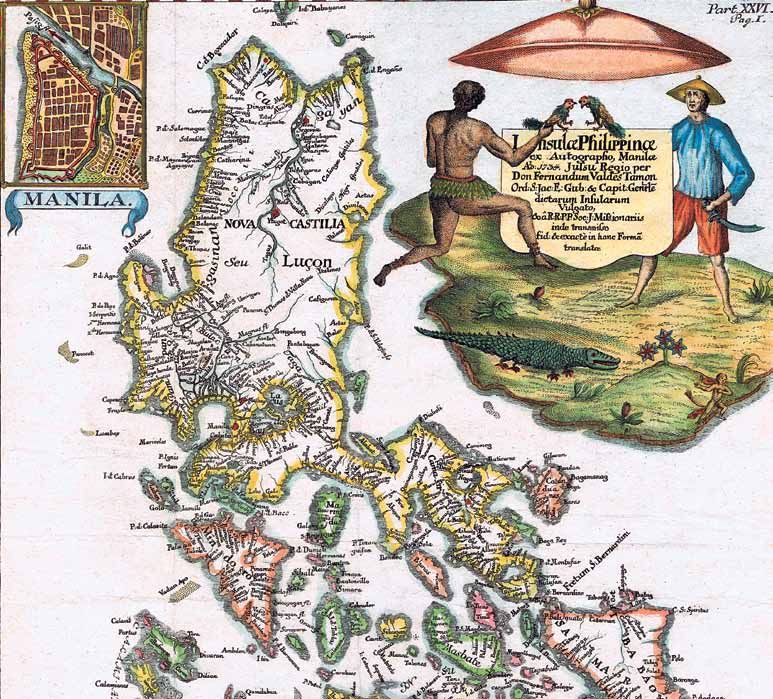
Front cover Detail from ‘Insulae
Please note that acceptance of an article for publication gives IMCoS the right to place it on our Philippinae’, 1748 by Leopold Johann
website and social media. Articles must not be reproduced without the written consent of the author Kaliwoda and Fernando Valdes Tamon
and the publisher. Instructions for submission can be found on the IMCoS website www.imcos.org/ after Murillo de Velarde, 1744, (2nd
imcos-journal. Whilst every care is taken in compiling this Journal, the Society cannot accept any edition). Courtesy Rudolf J. H. Lietz
responsibility for the accuracy of the information herein. collection, Gallery of Prints, Manila.
www.imcos.org 1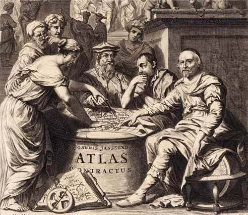
Geographia
                 Representations of mapmaking in the early modern period
                                                Michael Bischoff

The development of a particular geographical                attribute of Astronomy is an astrolabe and a ring of stars
iconography in the early modern period is the subject       around her head. Geometry is equipped with a compass
of this essay. The breathtaking progress in the sciences    or a measuring rod.3 ‘Geometria’ means measuring the
and the new knowledge gained about man and the              earth, or geodetic survey. In the illuminated twelfth-
natural world generated a demand for new artistic           century manuscript Hortus deliciarum by Herrad of
formswhich were able to visualise these successes.          Landsberg (c.1180) Geometry explains her role: ‘I
Geographical discoveries, too, were celebrated in           measure the earth with great care’.4 Although the
painting, sculpture and works of applied and graphic        prefix geo- means earth, in the curriculum of medieval
arts. Rodney Shirley, the foremost connoisseur of           universities it refered to the teaching of Euclidean
cartographic title pages, has already pointed out the       geometry, corresponding to the geometry lessons at
contemporary influence of the discoveries made in           today’s school, where the children are taught the clear
science and exploration and their side-by-side existence    concept of two- or three-dimensional space.
with classical allusions.1 He states the connection             It might have been for this reason that it was not
between iconography and the developing skills               until the sixteenth century that the personification
of surveying, astronomy, navigation, map and                of geometry not only appears with a compass or
chartmaking. Frontispieces and title pages of atlases, as   a measuring rod, but also with an earth globe.
well as the decorated margins of maps, offer space for      Geometry from the seven liberal arts series of engravings
an astonishing variety of representations of geography      by Cornelis Cort after Frans Floris (Fig. 1) is the
and mapmaking. Alongside the adaptation of suitable         pictorial translation the linguistic term. The female
models available to sixteenth-century artists new           personif ication of geometry wears a mural crown
iconographic inventions proliferated.                       with city walls and towers, the iconographic attribute
   During the Renaissance there were very few abstract      of Cybele. Her act of measuring an earth globe
ideas, philosophical concepts, manifestations of nature,    represents her function of surveying the earth’s surface.
social life or human behaviour which had not been               In ancient Greece Cybele assimilated aspects of the
depicted. Allegories, personifications and symbols          earth goddess Gaia and the harvest goddess Demeter.
formed a language, which the learned contemporary           In Roman times she was known as Magna Mater
viewer was able to decipher. Artists could rely on a        (Great Mother). In Renaissance iconography she
long iconographic tradition, which had taken shape in       represents the earth. The globe in Cort’s engraving
ancient and medieval times. Representations of the          not only refers to earth measuring in general but,
sciences were linked with the educational canon of          by turning the New World towards the spectator,
the seven liberal arts: grammar, rhetoric and logic,        emphasises the most important geographical discovery
arithmetic, geometry, music and astronomy.2 The term        of the early modern period.
originates from classical antiquity and describes the           The title page of Gerhard Mercator’s 1595 Atlas
knowledge considered essential for a free person to         shows a bearded muscular giant measuring a globe
take an active part in civic life. Their representation     with a compass.5 The title seems to refer to the titan
in the form of female personifications, equipped with       Atlas. In Greek mythology Atlas was condemned to
attributes, derives from the f ifth-century Roman           carry the vault of heaven on his shoulders. The name
author Martianus Capella. They are frequently found         of the bearer of the universe would seem an appropriate
in manuscripts and cathedral decoration dating back         title for a book containing maps which describe the
to the twelfth century.                                     surface of the earth. However, in the preface, Mercator
   The female figures of Astronomy and Geometry             makes clear that he is referring to a mythological
were predestined for adaptation since they embody           Mauritanian king of the same name. This king was an
two important aspects of early modern science:              expert in astronomy and he is credited to have been the
cosmography and land surveying. The traditional             first to interpret the heaven as a sphere. A second globe,

                                                                                                    www.imcos.org 15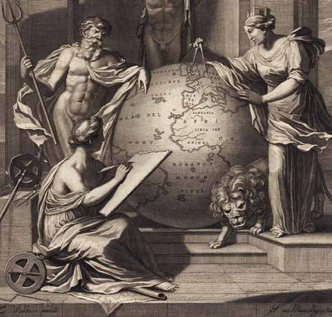
march 2018 No.152

                         Fig. 1 Geometry,
                         engraving, Cornelis
                         Cort after Frans Floris,
                         Antwerp: Hieronymus
                         Cock, 1565. Courtesy
                         Amsterdam,
                         Rijksprentenkabinet,
                         inv. RP-P-BI-6392.

                         Fig. 2 Geography guides
                         Gerhard Mercator’s
                         hand, engraving (detail),
                         Joannes de Visscher
                         after Zacharias Webbers,
                         in Atlas Contractus,
                         Amsterdam: Johannes
                         Janssonius Heirs, 1666.
                         Private collection.

14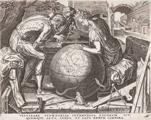
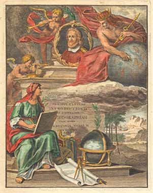
march 2018 No.152

clearly recognisable as an earth globe, suggests that
Atlas is not only interested in astronomy, but also in
geography. It is unclear whether the globe in Atlas’
hands is a celestial globe. One could interpret it as a
second earth globe which Atlas is copying with his
compass after the model on the ground by his legs. The
making of a globe would be the perfect allusion to the
cartographic products which Mercator’s book contains.
   Frans Hogenberg in his engraved portrait of
Mercator (1574) demonstrates that the image of the
measuring Atlas is applicable to the mapmaker. The
great cartographer is depicted presenting the result of
his work, a globe showing the north pole region
consisting of four islands, according to his 1569 world
map ‘Nova et Aucta Orbis Terrae Descriptio ad Usum
Navigantium emendatè accomodata’. With a compass,
Mercator points to one of his most important findings:
Earth’s magnetic pole.
   The splendid title page of the Atlas Contractus
(Amsterdam, 1666), published by the heirs of Johannes
Janssonius, is inspired by Hogenberg’s engraving
(Fig. 2).6 But there is a significant difference: the
mapmaker does not work independently. A woman
guides a compass in his hand. She is the personification     Fig. 3 Mauritanian king Atlas and Geography, coloured engraving,
of geography. In the seventeenth and eighteenth              in Philipp Cluver Introductio in universam geographiam, Amsterdam:
centuries she belonged to the standard stable of             Joannes Pauli, 1729 (1697). Private collection.

images used for geographical allegories and which
can be seen on many atlas title pages and frontispieces.     regionum (all regions of the world). But Cybele and
   Sometimes Geography, as well, acts with an assistant.     Neptune also appear in non-geographical contexts.
On the title page of a later edition of Philipp Cluver’s        Peter Paul Rubens, for instance, adapted the divine
Introductionis in universam geographiam […] libri VI         couple as the iconography for the city of Antwerp in
(Amsterdam, 1697) the Mauritanian king Atlas is              his painting The Union of Earth and Water (c.1618).9
explaining a celestial globe to Geography (Fig. 3).          Commonly Cybele and Neptune embody these two
On the title page, designed and engraved by Gerard de        elements. But Rubens added a contemporary meaning.
Lairesse for Nicolaes Visscher’s Atlas Minor (Amsterdam,     He linked it with a question of great importance to his
c.1683), Geography is documenting the geographical           hometown. The prosperous union of earth and water
data given to her by Neptune and Cybele.7 In Cort’s          stands for the union of Antwerp and the River Scheldt.
engraving (Fig. 1) the mural crown of Cybele, an             The estuary had been blocked off by the Dutch in
attribute of Geometry, emphasises the land surveying         1585, when the Spaniards conquered the city, depriving
aspect of this science. The presence of a lion confirms      Flanders of an access to the sea and endangering the
that the personification is meant to be the earth            prosperity of the town.10 The engraving Neptune and
goddess, since it is a typical attribute of Cybele. Cybele   Cybele by Pieter de Jode II, after Rubens,11 inspired
and the sea god Neptune represent land and sea. The          designers of atlas title pages, among them not only
sum of them constitutes the surface of the earth.            Gerard de Lairesse as mentioned above, but also his
   This duality is important. The idea of using Cybele       pupil Zacharias Webbers (Fig. 4).12 Again the two gods
and Neptune to depict the object of cartography occurs       are providing Geography with information about
for the first time on the title page of the second edition   the world. The frontispiece of the Atlas Contractus
of Abraham Ortelius’ Thesaurus Geographicus (Antwerp,        (Amsterdam, c.1700), designed by De Lairesse and
1596).8 The two gods act as a visual formula for the         published by Pieter Schenck, is another example of this
short summary given on the title page. Ortelius writes,      iconography.13 The Gerard Valk title page (Fig. 5)
that his reference book deals with Omnium totius terrae      varies the motif: Geography is working with a globe.14

16
Geographia

                                                                                               Fig. 4 Geography,
                                                                                               Cybele, Neptune
                                                                                               & Atlas, engraving
                                                                                               (detail), Johannes
                                                                                               Willemsz. van
                                                                                               Munnikhuyse
                                                                                               after Zacharias
                                                                                               Webbers, in English
                                                                                               Atlas, London:
                                                                                               Moses Pitt, 1680.
                                                                                               Private collection.

The globe demonstrates, as usual, that she is describing     Mercury is a woman who wears a crown in the
the world as a whole. But in this picture Geography          shape of the bows of a boat. She is lifting a model
is not only listening to Neptune and Cybele, but to          ship personifying shipping and navigation. This
another woman, who is presenting a regional map.             iconography perfectly fits with where this atlas was
Probably she is a personification of local geodetic          published: the seaport of Amsterdam. On the title page
surveying. She appears as a visualisation of the idea that   of the Atlas du Voyage de La Pérouse (Paris, 1797)17 the
the general view of the world depends on the sum of          personification of navigation is presenting a large world
many smaller cartographic units.                             map. Her attribute is a ship’s rudder. Two females are
   An alternative way of representing geography and          recording her geographical discoveries.
mapmaking is to replace the object of these sciences             On the title page of the second volume of George
with their driving forces. For instance, on the title        Louis Le Rouge’s Atlas portatif (Paris, 1759) are the
page of Pieter Mortier’s Atlas Minor or Atlas François       personifications of geography on the right and
(Amsterdam, 1695) there is a female with a map and           astronomy on the left.18 They are accompanied by
compass, representing geography or cartography.15            Chronos, who represents time. He is a winged old
She is being instructed by Mars, the god of war,             man with a scythe who is unveiling Astronomy. This
and Mercury, the god of commerce, travel and                 illustrates the idea that time brings new astronomical
communication. This iconography traces the progress          and geographical knowledge to light. It is a direct
of geography back to military and trade. On the title        adaptation of the classical motif from Renaissance
page of the first volume of Henri Abraham Chatelain’s        iconography of time unveiling truth.19 A variation
Atlas Historique (vol. 1, Amsterdam, 1705) one can           occurs on the frontispiece of Johann Hübner’s Reales
observe a detail that confirms that travel and trade         Staats-, Zeitungs-Lexicon (Leipzig, 1704). Here Time is
contributed to geographical knowledge.16 Replacing           instructing Geography who is recording the information.

                                                                                                     www.imcos.org 17
You can also read