Frontiers of the Roman Empire - The Lower German Limes - Nomination File for Inscription on the UNESCO World Heritage List Part III - Annex 2 | ...
←
→
Page content transcription
If your browser does not render page correctly, please read the page content below
Frontiers of the Roman Empire – The Lower German Limes

Nomination File for Inscription on the UNESCO World Heritage List

               Part III   –   Annex 2 | Management Plan
2 Management Plan
3

FRONTIERS OF THE ROMAN EMPIRE
   THE LOWER GERMAN LIMES

     MANAGEMENT PLAN
         2021–2027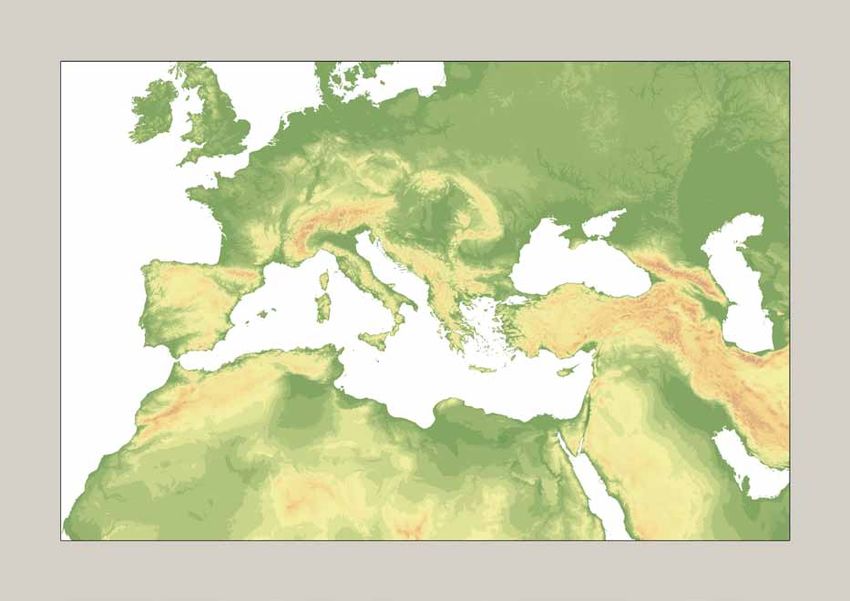
4

    Acknowledgements

    Programme manager
    Tamar Leene

    Main authors
    Tamar Leene, Lisa Berger

    Text contributions
    Steve Bödecker, Astrid Gerrits, Martijn Goedvolk, Tessa de Groot, Peter Henrich, Marinus Polak, Bianca Roelink,
    Loes van der Vegt, Lisa Wouters, Marenne Zandstra

    Final editing
    Jens Wegmann

    English correction
    Nigel Mills

    Design
    Christoph Duntze

    Printing
    LVR-Druckerei, Inklusionsabteilung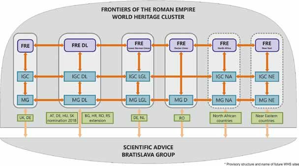
5

List of contents

MANAGEMENT PLAN – PART I         OVERARCHING FRAMEWORK                         9

1. Context, status and structure of the Management Plan                       10

   1.1 General introductionthe property                                       10

   1.2 Frontiers of the Roman Empire World Heritage site                      10

   1.3 Status of the Management Plan                                          11

   1.4 Involvement of stakeholders                                            12

   1.5 Terms and abbreviations                                                13

2. Value and importance of the Lower German Limes                             14

   2.1 The Lower German Limes                                                 14

   2.2 Statement on boundaries and buffer zones                               17

   2.3 The outstanding universal value of the Lower German Limes              17

3. Overarching structures for management and decision making                  22

   3.1 Guiding principles                                                     22

   3.2 Management of the Lower German Limes at a transnational level          23

4. Main management challenges                                                 26

   4.1 Long term objectives                                                   26

   4.2 Management Strategy                                                    26

   4.3 Risk management                                                        26

5. Overall monitoring and reporting to WHC                                    32

   5.1 Monitoring                                                             32

   5.2 Periodic Reporting to the WHC                                          32

MANAGEMENT PLAN – PART II         THE LOWER GERMAN LIMES IN THE NETHERLANDS   35

1. Objectives                                                                 36

2. Management structure in the Netherlands                                    38
6

       2.1 Management structure                                             38

       2.2 Partners                                                         40

    3. Protection and conservation                                          41

       3.1 Standards: Principles for planning and conservation              41

       3.2 Regulations                                                      41

       3.3 Working of the legal system                                      44

       3.4 Developments in and near the component parts                     45

    4. Presentation                                                         47

       4.1 Public awareness                                                 47

       4.2 Visitor management                                               50

    5. Knowledge and research                                               51

       5.1 Limes data                                                       51

       5.2 Research concept                                                 51

    6. Realisation                                                          52

       6.1 Implementation                                                   52

       6.2 Staffing                                                         53

       6.3 Participation and partners                                       53

    MANAGEMENT PLAN – PART III THE LOWER GERMAN LIMES IN GERMANY |
    RHINELAND-PALATINATE | NORTH RHINE-WESTPHALIA                           55

    PART A: MANAGEMENT PLAN                                                 56

    Overview                                                                56

    PART B: GUIDELINES FOR THE CONSERVATION, RESTORATION, RECONSTRUCTION,
    REBUILDING AND PROTECTIVE COVERING                                      70

    Definitions                                                             70

    General parameters                                                      70
7 Guidelines for future actions 71 International regulations 72 PART C: BASIC PARAMETERS OF A FUTURE STRATEGIC PRESENTATION PLAN (‘INTERPRETATION FRAMEWORK’) 73 Management Plan – Appendix 75 Appendix 1: Management plan actions 76
8
9

    MANAGEMENT PLAN

Part I – OVERARCHING FRAMEWORK
10 Management Plan
1. Context, status and structure of the
Management Plan
1.1 General introduction
Since 2005, a management plan is required by the UNESCO World Heritage Committee as part of the nomination
file. Management plans are aimed at upholding the Outstanding Universal Value (OUV) of World Heritage sites
(WHS) recognised by UNESCO. This involves:
• the protection, preservation, sustainable maintenance and management of the World Heritage site;
• the appropriate incorporation of new developments; and
• the propagation of the World Heritage site to society.
Protection is requisite and ensured by laws and regulations. In addition, the parties need to know how to deal
with modern development without harming the OUV of the Frontiers of the Roman Empire – The Lower German
Limes. It is important to understand that the Frontiers of the Roman Empire – The Lower German Limes is an
archaeological site, located in a densely populated region of Europe, including properties in the centre of cities
like Bonn and Utrecht. Integrating understanding and protection of the OUV with development over the long
term is essential for continuity of the OUV of the World Heritage site.
The management plan gives an overview on how the Frontiers of the Roman Empire – The Lower German Limes
will be managed during the period 2021–2027.
Part I of this management plan focuses on positioning the OUV of the World Heritage site, the Frontiers of the
Roman Empire – The Lower German Limes at the overarching, international level of this transnational serial
site. The management plan is an integral part of the nomination file (section 5.e). In Parts II and III, the Lower
German Limes in the Netherlands and in Germany are described as separate management units.
1.2 Frontiers of the Roman Empire World Heritage site
The northern border of the Roman Empire, the Limes, is the largest linear archaeological feature in Europe, part
of a larger structure encompassing also Northern Africa and the Middle East. Several sections of the Roman
Limes currently have World Heritage status. Hadrian’s Wall in Great Britain was the first part to be listed as a
World Heritage site, in 1987. In 2005 the Upper German-Raetian Limes was added to the list, followed in 2008
by the Antonine Wall (in Scotland). Together, they form a World Heritage site known as Frontiers of the Roman
Empire. When the Upper German-Raetian Limes was nominated, the World Heritage Committee recommended
‘that the nomination be seen as the second phase of a possible wider, phased, serial transboundary nomination
to encompass remains of the Roman frontiers around the Mediterranean Region’.
In 2017, a thematic study was presented to the World Heritage Committee, developed and adopted by the joint
partners of the Frontiers of the Roman Empire. This study provided an overview of the remains of the frontiers
of the Roman Empire, extending across the continents of Africa, Asia and Europe (fig. 1). In the thematic study,
five different frontier types were distinguished across the Frontiers of the Roman Empire as a whole, each type
displaying clear differences in the densities, disposition, type and size of military installations, reflecting vari-
ations in climatic and geographical conditions, habitation and land use, external threats and political interests.
These five groups are:
• the desert frontiers of the Roman provinces of Africa, Egypt, Arabia and southern Syria;
• the frontiers of northern Syria and Cappadocia (Turkey), constituting the frontier with the powerful Parthi-
an Empire in the East;
• the frontiers along the European rivers of the Rhine and the Danube;
• the artificial linear barriers of Hadrian’s Wall, the Antonine Wall and the Upper German-Raetian Limes
(the existing World Heritage site);Management Plan 11
• the mixed frontiers of the Roman province of Dacia (Romania), encapsulating the chronological and
geographical scope of the frontiers and their functional, chronological, social and cultural links and
complexity.
A nomination strategy was developed based on these five groups, providing the World Heritage Committee with
insight into the intended nominations of the Frontiers of the Roman Empire within Europe. Within this strategy,
it was agreed that the European frontiers should be divided into four single properties, operating under a com-
mon framework Frontiers of the Roman Empire.
• The artificial linear barriers of Hadrian’s Wall, the Antonine Wall and the Upper German-Raetian Limes.
• The Lower German (i.e. Lower Rhine) frontier.
• The Danube frontier.
• The frontier of the Roman province of Dacia.
The Frontiers of the Roman Empire – The Lower German Limes was identified as a prospective UNESCO World
Heritage site in 2011 in the Netherlands (by inscription on the Tentative List of Dutch World Heritage sites) and
in 2018 in Germany.
1.3 Status of the Management Plan
The Dutch State and the German States of North Rhine-Westphalia and Rhineland Palatinate are responsible
jointly, as the site manager, for the nomination and the adoption of the management plan, which complies with
the requirements of the UNESCO World Heritage Committee. The site manager is responsible for management
and plays an important role in the implementation of the management plan. Fig. 1 Frontiers of the
Following adoption by the steering group of administrators of the state governments and provinces (September Roman Empire.
antonine wall
frontiers of the
roman empire
hadrian’s wall
lower german
frontier
frontiers of the danube frontier
roman empire western segment
upper german-
raetian limes dacian
frontier
danube frontier
eastern segment12 Management Plan
2019), the management plan will be a binding plan for the site manager. The management plan provides the
basic principles and guidelines for the policies of all the signatories. It has no legal status itself, but the manage-
ment measures affect public authorities, private parties, owners and users/ operators. Following adoption by
the steering group, the management plan will be added to the nomination file to be submitted to the UNESCO
World Heritage Committee.
The management plan is adopted for a period of 6 years. The nomination of the Lower German Limes as a
World Heritage site will be submitted in 2020 for approval in 2021. This management plan therefore focuses on
the period 2021–2027. Included in the management plan are developments (opportunities or threats) considered
likely to manifest themselves during those 6 years. The administrative parties have committed themselves to act
in accordance with this management plan during the nomination phase (2018–2020). Three years after coming
into effect (2023), a mid-term review of this plan will take place.
1.4 Involvement of stakeholders
The management plan has been developed by the Dutch Limes Association together with the German States of
North Rhine-Westphalia and Rhineland-Palatinate. Local governments were involved from the beginning and
throughout the process of drawing up the management plan, through regular meetings and consultation. The
proposed boundaries of the World Heritage site have been approved by the municipalities. Discussions with key
stakeholders, such as regional water boards, heritage organisations, museums, universities and (other) NGOs
have also contributed to the management plan. Input from the local and wider community with an interest in
the site has been gathered and utilised. In those areas where extra protection measures were required, residents
and owners have been informed.
The final draft of the management plan, together with the nomination file, was open for consultation from
January 15 to March 1 in 2019 in the Netherlands. Local government and key stakeholders were approached
individually for their input. To give the wider community opportunities to voice their opinion, attention was
drawn to the consultation via a variety of media and networks. All comments received were considered, leading
to revision of the management plan where deemed necessary. The process of handling the input during the
consultation period has been documented in a consultation report.Management Plan 13 1.5 Terms and abbreviations OUV: Outstanding Universal Value means cultural and/or natural significance which is so exceptional as to tran- scend national boundaries and to be of common importance for present and future generations of all humanity. FRE: Frontiers of the Roman Empire. The border line of the Roman Empire at its greatest extent in the 2nd century AD. It stretched over 7,500 km from the Atlantic coast of northern Britain, through Europe to the Black Sea, and from there to the Red Sea and across North Africa to the Atlantic coast. LGL: Lower German Limes. Part of the Frontiers of the Roman Empire encompassing the north-eastern border of the Roman province of Germania inferior (Lower Germany), from Katwijk (NL) to Remagen (DE). Frontiers of the Roman Empire – The Lower German Limes: Full name of the proposed World Heritage site Property: The area(s) that is inscribed on the World Heritage List. A property can exist of more than one part. In that case it is a serial nomination. In cases where those areas are located in different states, it is a transnational serial nomination. Component part: an area, clearly defined, being a part of the Property, that contributes to the Outstanding Universal Value of the property as a whole. Buffer Zone: an area bordering the nominated property which has complementary legal and/or customary re- strictions placed on its use and development to give an added layer of protection to the property. Cluster: group of spatially separated parts of a single archaeological complex. World Heritage committee: a representative board that is composed of 21 members and that decides on the management of the World Heritage List. World Heritage Centre: Secretariat to the World Heritage Committee ICOMOS: the International Council on Monuments and Sites. A non-governmental organisation responsible for, amongst other matters, the evaluation of properties nominated for inscription on the World Heritage List
14 Management Plan
2. Value and importance of the Lower German Limes
2.1 The Lower German Limes
Overview
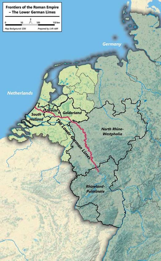
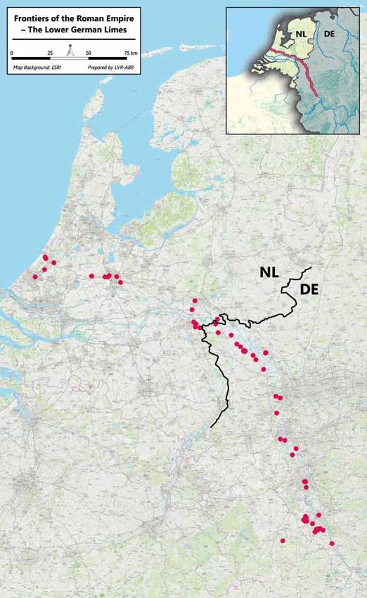
The Lower German Limes (LGL) forms an over 400 km section of the Limes from the border of Upper Germany
to the North Sea. It runs through the German states of Rhineland-Palatinate and North Rhine-Westphalia and
through the Dutch provinces of Gelderland, Utrecht and South-Holland and passes through various landscapes
(fig. 2). Most of the Lower German Limes’ military facilities have been preserved below ground. In many places,
layers with organic material offer very special conditions of preservation. The various elements of the Frontiers
of the Roman Empire – The Lower German Limes which extend along the Rhine like a string of pearls, together
with the river itself, form a border system that existed for over 400 years and still shapes both cities and coun-
tryside in many places.
History and military development
The first military infrastructure was established in the last decades BC, for the conquest of Germanic territo-
ries across the Rhine. Once this ambition had failed, the left river bank was converted into a fortified frontier
separating the ‘Romanised’ Gaulish hinterland from the ‘barbarian’ Germanic foreland. The first military bases
on the Lower Rhine represent the very beginning of the linear perimeter defence of the Roman Empire, which
would develop into a coherent frontier system extending over three continents in the 2nd century AD. The entire
range of military facilities such as legionary fortresses, practice camps, cavalry, infantry and fleet forts, fortlets,
watchtowers, roads and waterways are represented, reflecting strategic adaptation and development of military
engineering. The legions played a special role in this. Four legionary fortresses along this Limes section secured
and organised the border, and vexillations operated various production workshops for a wide range of goods.
Having survived a crisis in the late 3rd century AD, the frontier shared the phased disintegration of the Western
Roman Empire until the early 5th century AD.
Some of the latest military settlements became nuclei of the ecclesiastical and administrative infrastructure of
the Middle Ages. In post-Roman times too (and at certain places even today), the Lower German Limes had an
influence on the lives of people living in its vicinity. In the names of towns, woods, roads and meadows it makes
an important contribution to the area’s identity.
Wetland conditions
Situated in an area which has always been a wetland, with outstanding preservation conditions, the Lower
German Limes exhibits unique testimonies of water management strategies and constructions employed by
the military command of the Roman Empire. They provide unparalleled insights into military architecture,
shipbuilding, logistics and supply. These are exemplified by an excavated canal, massive quays and landing
platforms, specially adapted fort designs and road sections protected by timber revetments. Buried riverine
rubbish deposits constitute veritable treasure-chests of organic materials and artefacts bearing unique
information on frontier life and on vanished traditions such as notably that of river boat building.
Integrity and authenticity
The nominated component parts of the Frontiers of the Roman Empire – The Lower German Limes clearly bring
out the linear character of the frontier along the river Rhine. They cover its entire range of military installations
and relevant associated structures, explaining its functioning and development. The adaptation of military in-
frastructure to the dynamic river landscape is eminently illustrated by forts with specific designs, an excavated
canal and protective timber structures along riverbanks and road sections. Buried riverine deposits with well-
preserved artefacts and organic remains provide unique insights into the frontier system and frontier life.
Although several sites have been built over, the general state of conservation is satisfactory. The near absence of
aboveground remains is compensated by the outstanding preservation of buried features at many sites. CurrentManagement Plan 15
Fig. 2 LGL in the
Netherlands, North
Rhine Westphalia
and Rhineland-Pala-
tinate.16 Management Plan Fig. 3 Overview of the position of the selected component parts of the LGL.
Management Plan   17

legislation ensures effective protection of the property, enhanced by adequate buffer zones. The preservation of
abundant buried remains in dynamic urban areas demonstrates that, with due care, sustainable protection and
development can be compatible.
As an archaeological property, the Frontiers of the Roman Empire – The Lower German Limes has a very high
level of authenticity. Virtually all of the component parts that have been included in the nomination are under-
ground and remain unexcavated. Since the remains of the Frontiers of the Roman Empire – The Lower German
Limes are almost all below ground, their value needs appropriate presentation in order to be understandable
by the general public. This need has led to a number of innovative projects designed to visualise the defences
of some forts aboveground, while protecting the authenticity of the buried remains as well as the setting and
integrity of the surroundings. These visualisations and other post-Roman buildings and features overlying the
buried remains are treated as vertical buffer zones.

2.2 Statement on boundaries and buffer zones

The selection of component parts and buffer zones is an essential requirement for the establishment of effective
protection of the nominated components (fig. 3).

component parts

All component parts are well protected by monument protection laws. The nominated property Frontiers of
the Roman Empire – The Lower German Limes comprises 106 component parts, 79 of which are grouped in
17 clusters. An overview of the component parts/clusters and the elements of the frontier they represent is
provided in table 1.
The selected component parts and clusters are presented in detail in the catalogue of component parts, where
the main characteristics and their contribution to the proposed Outstanding Universal Value may be found un-
der the headings ‘Brief description’ and ‘Attributes and values’.

Buffer zones

Buffer zones give an added layer of protection to a property. An important function is the protection of views
and of the setting. For the Frontiers of the Roman Empire – The Lower German Limes the buffer zones often have
an important additional function, of safeguarding information that is relevant to the understanding of the values
and features included in the property.
This additional function applies amongst others when relevant attributes are expected but have not been se-
curely attested. They may for instance have been hinted at by surface finds or by limited observations during
small-scale building activities. In such cases there is normally not enough archaeological evidence for protection
under national or state laws, and thus an insufficient basis for nomination as a component part.
The additional function is also applicable when attested attributes cannot be sustainably protected, for instance
because they are located near vital infrastructure which is likely to need extension in the future, or in areas
where urban development is inevitable and protection cannot be ensured. Inclusion in a buffer zone guaran-
tees that the preserved information can be collected by excavation in conformance with the highest scientific
standards.

2.3 The outstanding universal value of the Lower German Limes

Proposed Statement of Outstanding Universal Value

Frontiers of the Roman Empire – The Lower German Limes ran for 400 km along the Lower Rhine, along the
north-eastern boundary of the Roman frontier province of Germania inferior (Lower Germany), from the Rhenish
Massif south of Bonn (Germany) to the North Sea coast (the Netherlands). For more than 450 years from the
late 1st century BC, it protected the Roman Empire against Germanic tribes which it considered as ‘barbaric’.
The first military bases were built in the last decades BC, for the conquest of Germanic territories across the river
Rhine. Once this ambition had failed the left river bank was converted into a fortified frontier separating Roman
Gaul from the ‘barbaric’ foreland. Military installations of widely varying types and sizes and associated civil
structures were built on the edge of the left river bank and linked by an infrastructural and logistical network.
18   Management Plan

                            id       name                                      country   municipality
                            1a       Valkenburg-Centrum | Kerkweg              NL        Katwijk
                            1b       Valkenburg-Centrum | Centrum              NL        Katwijk
                            1c       Valkenburg-Centrum | Raadhuis             NL        Katwijk
                            1d       Valkenburg-Centrum | Kerkhof              NL        Katwijk
                            2a       Valkenburg-De Woerd | North               NL        Katwijk
                            2b       Valkenburg-De Woerd | South               NL        Katwijk
                            3        Voorburg-Arentsburg                       NL        Leidschendam-Voorburg
                            4a       Corbulo’s canal | Vlietwijk               NL        Voorschoten
                            4b       Corbulo’s canal | Starrenburg             NL        Voorschoten
                            4c       Corbulo’s canal | Knippolder              NL        Voorschoten
                            4d       Corbulo’s canal | Vlietvoorde             NL        Leidschendam-Voorburg
                            4e       Corbulo’s canal | Rozenrust               NL        Leidschendam-Voorburg
                            4f       Corbulo’s canal | Romeinsepad             NL        Leidschendam-Voorburg
                            5a       Leiden-Roomburg | Park Matilo             NL        Leiden
                            5b       Leiden-Roomburg | Besjeslaan              NL        Leiden
                            6        Woerden-Centrum                           NL        Woerden
                            7a       Utrecht-Limes road | Zandweg              NL        Utrecht
                            7b       Utrecht-Limes road | Veldhuizen           NL        Utrecht
                            7c       Utrecht-Limes road | De Balije            NL        Utrecht
                            8a       Utrecht-Hoge Woerd | Castellum            NL        Utrecht
                            8b       Utrecht-Hoge Woerd | Langerakbaan         NL        Utrecht
                            9        Utrecht-Groot Zandveld                    NL        Utrecht
                            10       Utrecht-Domplein                          NL        Utrecht
                            11a      Bunnik-Vechten | Marsdijk                 NL        Bunnik
                            11b      Bunnik-Vechten | Provincialeweg           NL        Bunnik
                            12       Arnhem-Meinerswijk                        NL        Arnhem
                            13       Elst-Grote Kerk                           NL        Overbetuwe
                            14a      Nijmegen-Valkhof area | Valkhofpark       NL        Nijmegen
                            14b      Nijmegen-Valkhof area | Hunnerpark        NL        Nijmegen
                            15       Nijmegen-Hunerberg                        NL        Nijmegen
                            16a      Nijmegen-Kops Plateau | West              NL        Nijmegen
                            16b      Nijmegen-Kops Plateau | North             NL        Berg en Dal
                            16c      Nijmegen-Kops Plateau | East              NL        Nijmegen
                            16d      Nijmegen-Kops Plateau | Kopse Hof North   NL        Nijmegen
                            16e      Nijmegen-Kops Plateau | Kopse Hof South   NL        Nijmegen
                            17a      Berg en Dal-aqueduct | Mariënboom         NL        Nijmegen
                            17b      Berg en Dal-aqueduct | Swartendijk        NL        Berg en Dal/Nijmegen
                            17c      Berg en Dal-aqueduct | Cortendijk         NL        Berg en Dal
                            17d      Berg en Dal-aqueduct | Louisedal          NL        Berg en Dal
                            17e      Berg en Dal-aqueduct | Kerstendal         NL        Berg en Dal
                            18a      Berg en Dal-De Holdeurn | North           NL        Berg en Dal
                            18b      Berg en Dal-De Holdeurn | South           NL        Berg en Dal
                            19       Herwen-De Bijland                         NL        Zevenaar
                            27       Kleve-Keeken                              DE        Kleve
                            21a      Kleve-Reichswald | West                   DE        Kleve
                            21b      Kleve-Reichswald | East                   DE        Kleve
                            22       Till                                      DE        Bedburg-Hau
                            23       Kalkar-Kalkarberg                         DE        Kalkar
                            24       Kalkar-Bornsches Feld                     DE        Kalkar
                            25a      Uedem-Hochwald | Hochwald 1               DE        Uedem
                            25b      Uedem-Hochwald | Hochwald 2               DE        Uedem
                            25c      Uedem-Hochwald | Hochwald 3               DE        Uedem
                            25d      Uedem-Hochwald | Hochwald 4               DE        Uedem
Table 1 List of all
                            25e      Uedem-Hochwald | Hochwald 5               DE        Uedem
component parts of
Frontiers of the            25f      Uedem-Hochwald | Hochwald 6               DE        Uedem
Roman Empire – The          25g      Uedem-Hochwald | Hochwald 7.1             DE        Uedem
Lower German Limes.         25h      Uedem-Hochwald | Hochwald 7.2             DE        Uedem
Management Plan 19 id name country municipality 25i Uedem-Hochwald | Hochwald 8.1 DE Uedem 25j Uedem-Hochwald | Hochwald 8.2 DE Uedem 25k Uedem-Hochwald | Hochwald 9 DE Uedem 25l Uedem-Hochwald | Hochwald 10 DE Uedem 25m Uedem-Hochwald | Hochwald 11 DE Uedem 25n Uedem-Hochwald | Hochwald 12 DE Uedem 25o Uedem-Hochwald | Hochwald 13 DE Uedem 26a Wesel-Flüren | Flürener Feld 1 DE Wesel 26b Wesel-Flüren | Flürener Feld 2 DE Wesel 26c Wesel-Flüren | Flürener Feld 3 DE Wesel 26d Wesel-Flüren | Flürener Feld 4 DE Wesel 27 Xanten-CUT DE Xanten 28 Xanten-Fürstenberg DE Xanten 29 Alpen-Drüpt DE Alpen 30 Moers-Asberg DE Moers 31 Duisburg-Werthausen DE Duisburg 32 Krefeld-Gellep DE Krefeld 33 Neuss-Koenenlager DE Neuss 34a Neuss-Reckberg | Wachtturm DE Neuss 34b Neuss-Reckberg | Kleinkastell DE Neuss 35 Monheim-Haus Bürgel DE Monheim am Rhein 36 Dormagen DE Dormagen 37 Köln-Praetorium DE Köln 38 Köln-Deutz DE Köln 39 Köln-Alteburg DE Köln 40a Kottenforst Nord | Am Weißen Stein 1 DE Bornheim 40b Kottenforst Nord | Am Weißen Stein 2 DE Alfter 40c Kottenforst Nord | Domhecken 5 DE Alfter/Swisttal 40d Kottenforst Nord | Domhecken 1 DE Alfter 40e Kottenforst Nord | Domhecken 2 DE Alfter 40f Kottenforst Nord | Domhecken 3 DE Alfter 40g Kottenforst Nord | Domhecken 4 DE Alfter 40h Kottenforst Nord | Dürrenbruch 3 DE Alfter 40i Kottenforst Nord | Dürrenbruch 2 DE Alfter 40j Kottenforst Nord | Dürrenbruch 1 DE Alfter 40k Kottenforst Nord | Pfaffenmaar 1 and 2 DE Alfter 41 Bonn DE Bonn 42a Kottenforst Süd | Oben der Krayermaar DE Bonn 42b Kottenforst Süd | Villiper Bach DE Bonn 42c Kottenforst Süd | Professorenweg 1 DE Bonn 42d Kottenforst Süd | Professorenweg 2 DE Bonn 42e Kottenforst Süd | Riesenweg DE Bonn 42f Kottenforst Süd | Wattendorfer Allee 2 DE Bonn 42g Kottenforst Süd | Wattendorfer Allee 1 DE Bonn 42h Kottenforst Süd | Bellerbuschallee DE Bonn 42i Kottenforst Süd | Villiprot 1 DE Bonn 42j Kottenforst Süd | Heiderhof DE Bonn 43 Iversheim DE Bad Münstereifel 44 Remagen DE Remagen Having survived a crisis in the late 3rd century AD, the frontier shared the phased disintegration of the Western Roman Empire until the mid-5th century AD. Frontiers of the Roman Empire – The Lower German Limes eminently illustrates the innovative responses of the Roman military engineers to the challenges posed by the dynamic landscape of a lowland river, as witnessed by the positioning and design of the military installations and by exceptional water management works. The entire range of large early bases to small late strongholds is represented, reflecting strategic adaptation and develop-
20   Management Plan

     ment of military engineering. The first military bases on the Lower Rhine represent the very beginning of the
     linear perimeter defence of the Roman Empire, which would develop into a coherent frontier system extending
     over three continents in the 2nd century AD. The military and civil structures associated with the military for-
     tifications illustrate the formidable impact of the Roman military presence on the landscape and society of the
     periphery of the Empire.
     The wetland conditions have led to an outstanding preservation of timber and other organic remains, providing
     unparalleled insights into military construction, shipbuilding, logistics and supply.
     Criterion (ii): The extant remains of Frontiers of the Roman Empire – The Lower German Limes constitute
     significant elements of the Roman Frontiers present in Europe. With its legionary fortresses, forts, fortlets,
     watchtowers, linked infrastructure and civilian architecture it exhibits an important interchange of human and
     cultural values at the height of the Roman Empire, through the development of Roman military architecture,
     extending the technical knowledge of construction and management to the very edges of the Empire. It reflects
     the imposition of a complex frontier system on the existing societies of the north-western part of the Roman
     Empire, introducing for the first time military installations and related civilian settlements, linked through
     an extensive supporting network. The frontier did not constitute an impregnable barrier, but controlled and
     allowed the movement of peoples: not only the military units, but also civilians and merchants. Hence, it
     triggered the exchange of cultural values through movement of soldiers and civilians from different nations.
     This entailed profound changes and developments in terms of settlement patterns, architecture and landscape
     design and spatial organisation.
     Criterion (iii): As part of the Roman Empire’s general system of defence, Frontiers of the Roman Empire – The
     Lower German Limes has an extraordinarily high cultural value. It bears an exceptional testimony to the maxi-
     mum extension of the power of the Roman Empire through the consolidation of its north-western frontiers and
     thus constitutes a physical manifestation of Roman imperial policy. It illustrates the Roman Empire’s ambition
     to dominate the world in order to establish its law and way of life there in a long-term perspective. It witnesses
     Roman colonisation in the respective territories, the spread of Roman culture and its different traditions – mili-
     tary, engineering, architecture, religion management and politics – and the large number of human settlements
     associated with the defences which contribute to an understanding of how soldiers and their families lived in
     this part of the Roman Empire.
     Criterion (iv): Frontiers of the Roman Empire – The Lower German Limes was the earliest linear frontier of the
     Roman Empire, created as an answer to Rome’s inability to control its northern neighbours by means of diplo-
     macy. Its military installations outstandingly illustrate the development of the large operational bases of a field
     army to the varied range of smaller installations required by an extended frontier line. Situated in an area which
     has always been a wetland, with outstanding preservation conditions, Frontiers of the Roman Empire – The
     Lower German Limes exhibits unique testimonies of water management strategies and constructions employed
     by the military command of the Roman Empire. Buried riverine rubbish deposits constitute veritable treasure-
     chests of organic materials and artefacts bearing unique information on frontier life and on vanished traditions
     such as notably that of river boat building.

     Integrity

     The component parts of Frontiers of the Roman Empire – The Lower German Limes have been carefully selected
     to provide a good representation of the attributes and values of the proposed Outstanding Universal Value.
     They clearly bring out the early development of perimeter defence. They cover the entire range of military in-
     stallations and relevant associated structures of a frontier system, explaining its functioning and development.
     Distinctive aspects which are clearly brought out by the component parts are the responses of the Roman army
     to the dynamic river landscape and the large impact of the frontier on the landscape and its inhabitants.
     The general state of conservation is good to very good. More than three quarters of the component parts/clusters
     encompass nearly or largely complete elements of the frontier. All were exposed to the normal degradation
     of archaeological sites, but in most cases their intactness is good or very good, as witnessed by the presence
     of remains of the latest building phase. The rarity of aboveground remains is amply compensated by the
     outstanding preservation of the buried features. The sites are not exposed to significant threats, and current
     legislation warrants a proper protection of the property, enhanced by adequate buffer zones.

     Authenticity

     As an archaeological property, Frontiers of the Roman Empire – The Lower German Limes has a high level of
     authenticity. Virtually all the remains were buried during or soon after the Roman period and thus protected
Management Plan 21 against later alterations. The authenticity of form and design of nearly all elements is unaffected, because they have not undergone any changes after the Roman period. At half of the sites stone walls or timber and organic remains have been preserved to a level which permits the rating of their authenticity as unaffected. Elsewhere only the foundations of stone walls remain, or timber and organics have decayed, leading to a rating of the authenticity of materials and substance as fair. The location and setting of the elements of the frontier have in most cases considerably changed, by the embankment or canalisation of the Rhine, changes in land use and urbanisation. There are only four sites where the present setting is strongly reminiscent of the Roman landscape, although it can still be understood at half of the sites; at the other half the authenticity of location and setting is clearly compromised. Reconstructions occur at five sites, and these and other types of visualisation – evidently not pretending to be authentic – significantly contribute to the sustained protection of the property. Protection and management requirements The nominated property is legally protected by the national and state laws on heritage protection of Germany (federal states of North Rhine-Westphalia and Rhineland-Palatinate) and the Netherlands. Much of the responsibility rests with the owners and with local and regional authorities. The component parts will be primarily managed at the national (NL) and state (DE) levels, but the management of the nominated property is coordinated by a joint Dutch-German Management Group (MG), which is overseen by an Intergovernmental Committee (IGC). The joint Management Group sets out the main lines of the management and supervises the implementation of the national management plans and the periodic reporting to UNESCO. The role of the Management Group and its procedures will be laid down in a Joint Declaration. The management structures of Frontiers of the Roman Empire – The Lower German Limes will cooperate inten- sively with their counterparts for the existing World Heritage site Frontiers of the Roman Empire (Ref: 430ter) and the nominated property Frontiers of the Roman Empire – The Danube Limes (Western Segment) (Ref: 1608, nominated 2018), and with States Parties preparing the nomination of other sections of the Roman frontiers. A framework for this international cooperation is provided by the Frontiers of the Roman Empire World Heritage Cluster set up in 2018 to support international collaboration in those fields relevant to the overall management and development of the Frontiers of the Roman Empire in Europe as World Heritage.
22          Management Plan

                                  3. Overarching structures for management
                                     and decision making

                                  3.1 Guiding principles

                                  The Frontiers of the Roman Empire – The Lower German Limes is nominated as a transnational serial archaeo-
                                  logical site. The Netherlands and Germany are jointly responsible for the nomination, inscription, recognition
                                  and for safeguarding the OUV. They are also jointly responsible for effective long-term implementation of the
                                  management plan for the site, and for timely compliance with procedural requirements allowing for verification
                                  by UNESCO through periodic monitoring reports. Basic principles of the management structure are:

                                        •   taking into account the differences between both countries;
                                        •   acting in accordance with each partner’s own responsibility;
                                        •   decision-making that focuses as much as possible on consensus;
                                        •   acting in compliance with guidelines developed at FRE level.

                                  The Netherlands and Germany have their own legal and planning system with different instruments and dif-
Fig. 4 Organisational             ferent authorities at the various government levels. The characteristics and customs of practice at national,
structure of the
                                  regional and local level differ between the two countries. Therefore, at national level both countries have their
Frontiers of the
Roman Empire – Low-               own management structure for implementation of the management plan. The transnational character requires
er German Limes                   a transnational structure to coordinate and evaluate all activities at a strategic level. Consequently, a multilevel
World Heritage site               management structure has been established (fig 4; table 2).

                                                                                             FRONTIERS OF THE ROMAN EMPIRE WORLD
         UNESCO WORLD HERITAGE CONVENTION
                                                                                                        HERITAGE CLUSTER

                                                                                                          Bratislava Group
    World Heritage Convention                  ICOMOS
                                                                                                          Scientific advice

                                UNESCO                                                             Frontiers of the Roman Empire

    Kingdom of the Nederlands                                                                                                        German Federal
           (Minister OCW)                                                                            LGL Inter-Governmental             Republic
                                                                                                            Commitee

                                                                                                                                                                  German
       LGL-NL Steering Group                                                                                                                                  Limes Commission
  (RCE, provinces, 2 municipalities*)
                                                                                                              LGL                     Federal States
                                                        LGL-NL Coordination point
                                                                                                        Managementgroep
                                                                                                                                       North Rhine-
                                                                                                                                     Westphalia and
                                                                                                                                   Rhineland-Palatinate
             LGL-NL MG                            LGL-NL programme            LGL-NL
                                                       team +            programme team                Lower German Limes
         (provinces and RCE)
                                                   (municipalities,       (provinces, RCE)
                                                   provinces, RCE)

    Working group              Working group              Working group                        Working group KNOWLEDGE                 Working group museums along the
     PROTECTION              PUBLIC AWARENESS             PRESENTATION                       International research and science                  German LGL
                                                    Presentation, interpretation,                                                           Presentation, imparting
                                                               design

      FUNCTIONAL RELATIONS
      ADVICE
Management Plan 23
Level Focus Paragraph Table 2 Overview of
the national and
Frontiers of the Roman Empire Exchange of best practice. 3.3
transnational levels
Lower German Limes Strategic management of the Lower German Limes 3.2 established to
Monitoring and reporting 5
coordinate and
evaluate activities
Exchange of best practice 3.2 and the referring
National Implementation of the management plan at national level Part II: The Netherlands paragraphs here in
Involvement of stakeholders in management Part III: Germany the text.
3.2 Management of the Lower German Limes at a transnational level
At a transnational level, a two layered organisation will be formed comprising an Intergovernmental Committee
(IGC) and a Management Group (MG). The IGC is responsible for long-term commitment and strategic
management decisions. Also, in the case of emergencies, the IGC will be the platform for providing advice to
the responsible governments. The IGC will meet at least once every three years or more often if needed.
The MG will be responsible for operational cooperation between both countries and for day-to-day management
of the sites and is formed of representatives from the two national management structures.
The Intergovernmental Committee (IGC-LGL)
The IGC-LGL is collectively responsible for the long-term protection of the World Heritage site following
nomination on a consensus basis. The IGC-LGL consists of:
• two representatives from the Netherlands;
• one representative from North Rhine-Westphalia;
• one representative from Rhineland-Palatinate.
The IGC-LGL is responsible for:
• contributing to and ensuring the continuing and further reinforcement of support and enthusiasm for the
World Heritage site among stakeholders and in society;
• safeguarding harmonisation in the implementation of the management plan. In practical terms, this
concerns the harmonisation of management systems and processes for all the individual properties of
the Frontiers of the Roman Empire – The Lower German Limes, in order to operate in accordance with a
common set of objectives for the protection of the OUV;
• timely administrative identification of and reaction to threats and developments that might affect the OUV
of the World Heritage site (for example outcomes of Heritage Impact Assessments);
• ensuring the raising of the necessary means for implementation of the management plan, including the
organisational functions necessary for practical implementation of management measures;
• Ensuring timely compliance with monitoring and reporting obligations to UNESCO.
• The IGC-LGL appoints one of its members as chairman and meets once every three years.
LGL Management Group
The Management Group for the nominated Frontiers of the Roman Empire – The Lower German Limes World
Heritage site (MG-LGL) is made up of those directly responsible for management of the currently inscribed
sections of the LGL in both countries (site managers). The MG-LGL provides the primary mechanism for sharing
best practice in relation to the Frontiers of the Roman Empire – The Lower German Limes, for coordinating
transnational projects and for preparing the work of the IGC.
Site manager (management structure)
The site manager is charged with:
• ensuring, on behalf of the steering group, the protection of the World Heritage site as a whole, as well as
a long-term adequate protection of the OUV;
• drawing up the management plan;24 Management Plan
• ensuring the implementation of the management plan at national/state level in accordance with the cycle:
planning, implementation and execution, monitoring, evaluating and adjusting;
• ensuring compliance with the periodic (six-year) reporting obligations towards UNESCO;
• ensuring the required communication, harmonisation, coordination and collaboration between the
different parts of the FRE;
• ensuring, together with all the parties concerned, the availability of sufficient resources for the implemen-
tation of management measures;
• ensuring timely consultation and agreement with the steering group and, if necessary, with each separate
member of the steering group, to achieve the administrative safeguarding of the harmonisation required
by UNESCO in the implementation of the management plan;
• timely administrative identification of and reaction to threats and developments that might affect the OUV
of the World Heritage site;
• being the first point of contact for national governments and providing them with knowledge and advice
concerning management delivery;
• being the contact for stakeholders at national/state level;
• stimulating mutual exchange of knowledge and management expertise at the level of the FRE.
In Germany, the site manager for the Frontiers of the Roman Empire – The Lower German Limes is employed
since 2015 in a permanent position at the LVR-State Service for Archaeological Heritage. The site manager also
attends the regular meetings of the DLK, which coordinates management of the Frontiers of the Roman Empire
World Heritage site in Germany.
LVR-Amt für Bodendenkmalpflege im Rheinland (LVR-State Service for Archaeological Heritage)
Endenicher Str. 133
53115 Bonn
T +49 228 9834184
M steve.boedecker@lvr.de
W www.bodendenkmalpflege.lvr.de
In the Netherlands, the site manager function is invested with the province of Utrecht, which acts on behalf of
the three Dutch provinces (Utrecht, South Holland and Gelderland)
Nederlandse Limes Samenwerking
p/a Provincie Utrecht
Archimedeslaan 6
3584 BA Utrecht
T +31 30 2589111
M info@limessamenwerking.nl
W www.limeswerelderfgoed.nl
Focal points
In each member state, a ‘Focal Point’ is designated as a basis for compliance with the procedural requirements,
particularly in respect of periodic reports. In the Netherlands, this position is fulfilled by the Cultural Heritage
Agency of the Netherlands (RCE) and in Germany by the Federal Foreign Office. In both countries, the UNESCO
Focal Points work in close cooperation with the site manager.
Rijksdienst voor het Cultureel Erfgoed (Cultural Heritage Agency)
Smallepad 5 3811 MG Amersfoort
T +31 33 4217421
M info@cultureelerfgoed.nl
W www.cultureelerfgoed.nlManagement Plan 25
National World Heritage Focal Point
Auswärtiges Amt Referat 603-9 Koordinierungsstelle Welterbe
Werderscher Markt 1
10117 Berlin
Postal address: 11013 Berlin
W www.auswaertiges-amt.de/en
M birgitta.ringbeck@diplo.de
3.3 Cooperation with other parts of the Frontiers of the Roman Empire
In order to support international collaboration in those fields relevant to the overall management and develop-
ment of the Frontiers of the Roman Empire as World Heritage, in 2017 it was agreed by the European states that
an overarching framework was needed. The primary aims of this overarching framework are the presentation of
the Roman frontiers as a single, coherent monument and the furthering of international cooperation to facilitate
management and development of the inscribed properties.
In 2018 European State parties developed for this purpose the Frontiers of the Roman Empire World Heritage
Cluster (fig. 5). The existing Bratislava Group forms the basis of this cluster. Within the cluster, there is
cooperation at management and strategic levels. It is proposed that all existing and possible future properties
will together form an intergovernmental committee and a management group. Exchange of knowledge will take
place between both groups. A formal meeting will be held between representatives of the properties inscribed
every three years.
Bratislava Group
The Bratislava Group is an international scientific advisory body with expert members from States Parties along
the frontiers of the Roman Empire. It consists of experts and scientists from the countries that have included
their national sections of the Limes on the World Heritage List and delegates from countries that have applied for
the UNESCO tentative list. The members of the group meet to discuss how to document the Limes sites, how to
build an international and national database and how to establish management standards. The group is working
to set up a scientific framework for the whole site and bridge the differences which come from individual
research traditions. The first meeting of the group took place in Bratislava in 2003, which is how it received
its name. The long-term goal of the Bratislava Group is to include on the UNESCO list all the appropriately
preserved sections of the Limes in Europe, the Middle East and North Africa. The Bratislava Group supports
States Parties by advising on the significance of the Roman frontiers and on the development of best practice
guidance for their management and improvement of understanding.
Fig. 5 Management
structure for the
‘Frontiers of the
Roman Empire World
Heritage Cluster’.26 Management Plan
4. Main management challenges
4.1 Long term objectives
The long-term strategy for the Frontiers of the Roman Empire – The Lower German Limes is aimed at preserving
the OUV and creating a common understanding of it. This long-term strategy is translated into six long term
aims:
• Frontiers of the Roman Empire – The Lower German Limes is sustainably protected. Researchers and
governments work together on preservation and development of knowledge.
• Frontiers of the Roman Empire – The Lower German Limes is known and acknowledged as a transnational
structure within both counties and abroad.
• Frontiers of the Roman Empire – The Lower German Limes is part of the Frontiers of the Roman Empire
(FRE). At FRE level there is alignment with regard to preservation, interpretation, research and public
access.
• Frontiers of the Roman Empire – The Lower German Limes is used as an educational resource in primary
and secondary education.
• Frontiers of the Roman Empire – The Lower German Limes is known as a structure that stretches along the
Rhine, running through both countries. This structure is accompanied by high quality public presentation
(museums/landscape) and is used for leisure and as a tourist destination.
• Frontiers of the Roman Empire – The Lower German Limes is a source of inspiration for the local
environment/communities. Local residents are proud of the presence of this historical frontier.
• Actions have been developed to implement these long-term aims (Appendix 1). These aims will be adjusted
and updated in future management periods.
4.2 Management Strategy
The Netherlands and the German states of North Rhine-Westphalia and Rhineland-Palatinate jointly coordinate
and control the management of the component parts as a whole. Responsibility for the implementation of
management measures is placed and will remain at the lowest possible level, with the organisation that is best
equipped to deliver these measures in line with the legal and planning systems in both countries. Each state
is responsible for the preservation and management of its respective component parts and for managing any
impacts that may arise from wider factors and events.
At the level of the component parts, an individual management plan will be drafted for each site to ensure
detailed implementation of the management plan and its requirements.
At the level of the Lower German Limes, the aim is to preserve and further develop the recognisability of the
Frontiers of the Roman Empire – The Lower German Limes as a whole and as part of the Frontiers of the Roman
Empire. For these purposes, common standards will be developed in the fields of interpretation, presentation
and communication and projects will be initiated at the level of the Frontiers of the Roman Empire – The Lower
German Limes as a whole and as part of the Frontiers of the Roman Empire.
4.3 Risk management
Many of the preserved archaeological remains are well protected against most threats by their underground
location. Some elements preserved aboveground have been integrated into later buildings, a process that has
ensured their preservation down to the present day. All elements are well protected by the national and stateManagement Plan 27
heritage protection laws.
(i) Development pressures
Frontiers of the Roman Empire – The Lower German Limes is characterised on the one hand by large areas of
intensive agricultural use and on the other hand by urban areas up to one thousand years old. In consequence
the main factors affecting the property are agricultural activities and urban and industrial growth.
German spatial planning law1 aims to foster a balanced settlement and open space structure, which at the same
time takes into account the preservation of the environment.2 Urban sprawl should be avoided and an effective
infrastructure maintained. Rural areas are to be developed and recreational areas promoted.
The State Development Plan of North Rhine-Westphalia3 and Rhineland-Palatinate4 aim to achieve sustainable
development that balances social and economic spatial requirements with ecological requirements. Archaeological
remains are mentioned several times in the context of protecting the cultural landscape. Within the federal states
of North Rhine-Westphalia and Rhineland-Palatinate, regional plans5 give functional substance to implementing
the objectives formulated in the spatial planning law. The Lower German Limes features actively in the regional
plan by being mentioned in the text and in overview maps.
In the Netherlands an overall policy regarding space and mobility is formulated by the Ministry of Infrastructure
and Water Management, based on the national planning law.6 A vision up to 2040 has been laid down in a
memorandum on infrastructure and spatial planning.7 The balancing of landscape and urbanisation is the
responsibility of the provinces, and their policies have been laid down in provincial memoranda.8 Detailed
planning is realised by the municipalities through zoning plans.
In all, 20 component parts/clusters are located in city centres or other built-up areas. In most cases the Roman
remains are well protected by thick post-Roman settlement layers. At first sight overbuilding of archaeological
sites may be seen as a threat to the underground remains, but there are many instances where it has protected
the sites against later erosion. At Utrecht-Domplein, for instance, the Roman fort has survived in good condition
thanks to the accumulation of thick medieval occupation layers. At Nijmegen-Hunerberg and Bonn studies
of the areas occupied by the legionary fortresses have demonstrated that on the whole only the cellars of
modern buildings have destroyed Roman remains, and that more than eighty percent of the areas built over are
sufficiently intact. Observations in built-up areas elsewhere point to similar conditions. In some cases, the layout
of modern towns reflects the underlying Roman layout, as at Neuss-Koenenlager, where the main road through
the legionary fortress is still recognisable in the modern street plan.
Small-scale threats caused, for example, by the installation of power cables do not affect the Outstanding
Universal Value, even if they involve some loss of the original substance. These interventions often take
place where the archaeological substance has already been destroyed by previous, similar interventions.
More substantial interventions such as cellars or underground car parks are handled very restrictively, and
rescheduling and shallow foundations are the usual responses. All interventions within the nominated property
require permission in accordance with the monument protection laws and can only be carried out following
approval by the responsible authorities, in accordance with the state and national heritage laws, and under
archaeological supervision.
It is not always necessary to avoid building or rebuilding in protected areas, as long as the attributes of the
Outstanding Universal Value are not affected. All underground works in the nominated property require
permission in accordance with the state and national laws on heritage protection. Damage to archaeological
remains can be prevented or reduced to a minimum by what is termed ‘archaeology-friendly building’. This
encompasses a broad range of measures including preparatory raising of the surface, adapting foundation plans
and clustering underground infrastructure.
1 Raumordnungsgesetz (1997, last revision 2017).
2 Umweltverträglichkeitsprüfungsgesetz (UVPG) (2010, last revision 2019).
3 Landesentwicklungsplan Nordrhein-Westfalen (2016).
4 Landesentwicklungsprogramm Rheinland-Pfalz (LEP IV) (2008).
5 Regionalpläne: Regierungsbezirk Düsseldorf (2018), Regierungsbezirk Köln – Teilabschnitt Region Köln (2018), Regierungsbe-
zirk Köln – Teilabschnitt Region Bonn/Rhein-Sieg (2009); Regionaler Raumordnungsplan Mittelrhein-Westerwald (2017).
6 Wet ruimtelijke ordening (2018).
7 Structuurvisie Infrastructuur en Ruimte (2012). In June 2019 a draft has been presented of the National Environmental Vision
[Nationale Omgevingsvisie], a memorandum which will replace the former document once the Environment and Planning Act
[Omgevingswet] will enter into force in January 2021.
8 Gelderland: Omgevingsvisie Gelderland (2018). Utrecht: Provinciale Ruimtelijke Structuurvisie 2013–2028 (revised 2016). South
Holland: Visie Ruimte en Mobiliteit (2014; revised 2018).28 Management Plan
Many of the elements of Frontiers of the Roman Empire – The Lower German Limes have been scheduled
monuments for decades and their protection by the judicial and administrative framework has been very
successful. In agreement with the municipalities involved, protection of the nominated property is also set out
in the management plan.
Industrial development
Industrial development is largely confined to the periphery of cities. In Germany the planning of industrial areas
is carried out on a long term basis and can be co-designed by the state conservation agencies. All underground
works in the nominated property require permission in accordance with the monument protection laws. At
Krefeld-Gellep the nominated property lies directly next to an industrial area that has been expanded in recent
years. During this expansion, restrictive measures were developed for the future in cooperation with the LVR-
State Service for Archaeological Heritage and the municipality of Krefeld.
In the Netherlands, the planning of industrial areas is primarily a concern of the provinces, but the realisation is
often carried out at the level of the municipalities. All activities disturbing the soil are subject to the regulations
of the national heritage protection law. At Valkenburg-De Woerd the area covered by the component parts is
designated for development into a small business park, but the plans will have to comply with the national law
on heritage protection. The component part Herwen-De Bijland borders a small industrial area, but is designated
for agricultural use in the current municipal zoning plan.
Traffic
The expansion of existing or construction of new roads and railway lines is difficult to forecast and to avoid.
Each intervention requires the consent of the heritage protection laws and can only be implemented in accor-
dance with these. In the case of existing infrastructure installations such as railway embankments it is quite
possible that any remains underneath are well preserved and protected.
Roads running through component parts do not harm the underground substance. Traffic passing over Roman
military installations and other structures (e.g. via country roads in Till or a main road in Neuss) does not
endanger the underlying structures. Exhaust gases do not damage the component parts in any way.
There is no case of interference with the archaeological substance by railway lines in any of the component
parts. At Xanten-Fürstenberg, for example, the railway line is not included in the nominated property in the
area where the line runs in a deep cutting, but is included further south where the line runs on a railway em-
bankment above the archaeological remains. At Bunnik-Vechten a main railway line has been included in the
buffer zone.
Wind energy
So far only two wind turbines occur in the immediate surroundings of the nominated property, in the buffer
zone of Till. Visibility is not affected nor is any other aspect of the Outstanding Universal Value. In North Rhine-
Westphalia wind turbines will not in future be allowed closer than 1,5 km from the nearest settlement.
The problem of wind turbines at World Heritage sites has received special attention in recent years.9 At the time
of writing, a ‘Wind Energy Decree’ is about to be published in the Ministerial Gazette of the State of North
Rhine-Westphalia and thus to enter into force. The decree will make it difficult to build new turbines within this
zone. There are no conflict zones with wind turbines in Rhineland-Palatinate and the Netherlands.
Major linear facilities
At Bunnik-Vechten a pipeline for aviation fuel runs immediately south of and parallel to the A12 motorway. Part
of the pipeline was relocated southward during the extension of the motorway in c. 1995, but only following
excavation of the area to be destroyed. In case of a further southward extension of the motorway – which is not
currently foreseen, but may be unavoidable at some point in the future – the pipeline will have to be moved
again. Both works require permission under the national heritage protection law.
9 P.Henrich (ed.), Regenerative Energien und Welterbestätten. Workshop der Deutschen Limeskommission am 23. November 2011
in Düsseldorf. Beiträge zum Welterbe Limes Sonderband 2 (Bad Homburg 2013).You can also read