Guidelines for Geographic Names 2010 - Version 2 A guide to naming or renaming features, localities and roads in Victoria
←
→
Page content transcription
If your browser does not render page correctly, please read the page content below
Guidelines for
Geographic Names 2010
                                  Version 2

 A guide to naming or renaming features,
            localities and roads in Victoria
ISBN 978-1-74242-663-1 (print) ISBN 978-1-74242-625-9 (online)

For more information contact the DSE Customer Service Centre 136 186

Published by the Victorian Government
Department of Sustainability and Environment Melbourne
January, 2013
© The State of Victoria Department of Sustainability and Environment 2013
This publication is copyright. No part may be reproduced by any process except in accordance with the
provisions of the Copyright Act 1968.
Authorised by the Victorian Government,570 Bourke Street, Melbourne
Disclaimer
This publication may be of assistance to you but the State of Victoria and its employees do not guarantee
that the publication is without flaw of any kind or is wholly appropriate for your particular purposes and
therefore disclaims all liability for any error, loss or other consequence which may arise from you relying on any
information in this publication.
Accessibility
If you would like to receive this publication in an accessible format,
such as large print or audio, please telephone 136 186, or email
customer.service@dse.vic.gov.au
Deaf, hearing impaired or speech impaired? Call us via the National Relay Service on 133 677 or visit
www.relayservice.com.au

Section 1: Purpose and Principles ................................................................................... 1
   1.1 What are these guidelines? .................................................................................... 1
   1.2 How do these guidelines work? ............................................................................. 1
   1.3 Why is there a need for these naming guidelines? ............................................... 2
   1.4 What can be named or renamed using these guidelines?.................................... 2
   1.5 Who can name or rename features, localities and roads in Victoria, and who
   oversees the process? .................................................................................................. 3
        (a) Members of the public ........................................................................................ 5
        (b) Stakeholders ...................................................................................................... 5
        (c) Naming authorities .............................................................................................. 5
        (d) Minister responsible for the Geographic Place Names Act 1998 ........................ 5
        (e) Registrar of Geographic Names ......................................................................... 6
        (f) Geographic Place Names Advisory Panel and committees ................................. 6
           Reasons why a committee may be convened ...................................................... 6
           How a committee is convened ............................................................................. 6
           What a committee considers ................................................................................ 7
           How a committee decides .................................................................................... 7
   1.6 What are the Register of Geographic Names and VICNAMES? .......................... 8
   1.7 Status of names in VICNAMES ............................................................................... 9
   1.8 Principles ............................................................................................................... 10
     Principle 1(A) Language ............................................................................................ 10
     Principle 1(B) Recognising the public interest ............................................................ 10
     Principle 1(C) Ensuring public safety ......................................................................... 10
     Principle 1(D) Ensuring names are not duplicated ..................................................... 11
     Principle 1(E) Directional names to be avoided.......................................................... 11
     Principle 1(F) Assigning extent to a feature, locality or road ...................................... 12
     Principle 1(G) Linking the name to the place ............................................................. 12
     Principle 1(H) Using commemorative names ............................................................. 12
     Principle 1(I) Using commercial and business names ................................................ 13
     Principle 1(J) Names must not be discriminatory ....................................................... 13
     Principle 1(K) Recognition and use of Indigenous Australian names ......................... 13
          Procedure .......................................................................................................... 13
     Principle 1(L) Dual names ......................................................................................... 14
     Principle 1(M) Consulting with the public ................................................................... 15
          Procedure .......................................................................................................... 15
          A step-by-step guide to the consultation process ............................................... 17
             Step 1 Prepare a naming proposal ................................................................. 17
             Step 2 Develop a consultation strategy .......................................................... 17
             Step 3 Determine who should be consulted ................................................... 17
             Step 4 Build awareness of the proposal and invite feedback .......................... 17
             Step 5 Analyse feedback from the community................................................ 17
     Principle 1(N) Lodging, considering and addressing objections ................................. 18
          What is an objection?......................................................................................... 18
          Lodging objections ............................................................................................. 18
          Considering objections....................................................................................... 18
          Addressing objections ........................................................................................ 18
     Principle 1(O) Notification of a naming decision ......................................................... 19
          Procedure .......................................................................................................... 19
     Principle 1(P) Signage ............................................................................................... 20
   1.9 Other legislation, regulations and policies relevant to geographic naming...... 20
   1.10 Updating these guidelines .................................................................................. 20

                                                  Guidelines for Geographic Names 2010 (Version 2 October 2012
                                                                                                        Page i
Section 2: Features ......................................................................................................... 21
   Definition ...................................................................................................................... 21
   Using this section of the guidelines........................................................................... 21
   2.1 Naming principles that apply to features ............................................................. 21
     Principle 2(A) Feature type ........................................................................................ 21
     Principle 2(B) Waterways .......................................................................................... 21
     Principle 2(C) Locational names ................................................................................ 22
     Principle 2(D) Base names ........................................................................................ 22
   2.2 Features with private companies or persons as the naming authority ............. 22
     2.2.1 Why these names should be recorded .............................................................. 23
     2.2.2 Value to the owners and the public ................................................................... 23
     2.2.3 How to record names in VICNAMES................................................................. 23
     2.2.4 Status of these names in VICNAMES ............................................................... 23
   2.3 Features with municipal councils as the naming authority ................................ 23
     2.3.1 How to initiate a proposal.................................................................................. 23
          General public.................................................................................................... 23
          Emergency response or other public service providers ...................................... 24
          Municipal council ............................................................................................... 24
     2.3.2 Formal proposal process .................................................................................. 25
            Step 1 Check information ............................................................................... 25
            Step 2 Check for conformance with the principles .......................................... 25
            Step 3 Consult with Indigenous communities ................................................. 25
            Step 4 Consult with emergency response and other service providers........... 25
            Step 5 Consult with the public ........................................................................ 26
            Step 6 Consideration by council ..................................................................... 26
     2.3.3 Lodging a proposal with the Office of Geographic Names (OGN) ..................... 26
     2.3.4 Registrar’s consideration of proposal ................................................................ 27
     2.3.5 Gazettal of a proposal ....................................................................................... 27
     2.3.6 Registration and notification .............................................................................. 28
     2.3.7 Historical information ........................................................................................ 28
     2.3.8 Signage ............................................................................................................ 28
   2.4 Features with State Government departments or authorities as the naming
   authority ....................................................................................................................... 28
     2.4.1 Guidelines for specific departments or authorities ............................................. 29
     2.4.2 General guidelines for State Government departments and authorities ............ 29
     2.4.3 Departmental processes for determining a naming proposal............................. 29
             Step 1 Developing a name in-house .............................................................. 29
             Developing a name through a public competition ........................................... 29
             Step 2 Apply the principles ............................................................................. 30
             Step 3 Consult with Indigenous communities ................................................. 30
             Step 4 Consult with emergency response and other stakeholders ................. 30
             Step 5 Consult with the public ........................................................................ 30
             Step 6 Contact the Registrar of Geographic Names ....................................... 30
     2.4.4 Registrar’s consideration of a proposal ............................................................. 31
        (a) Seeking an endorsement .................................................................................. 31
        (b) Seeking referral to a committee ........................................................................ 31
     2.4.5 Gazettal of a proposal ....................................................................................... 31
     2.4.6 Registration and notification .............................................................................. 32
     2.4.7 Signage ............................................................................................................ 32

                                                  Guidelines for Geographic Names 2010 (Version 2 January 2013)
                                                                                                         Page ii
2.5 Features with traditional Indigenous Australian names ..................................... 32
     2.5.1 Official registration of a traditional Indigenous Australian name ........................ 33
        Developing the registration proposal ...................................................................... 33
            Step 1 Identifying the name............................................................................ 33
            Step 2 Locate other names for the feature ..................................................... 33
            Step 3 Verifying the name .............................................................................. 33
            Step 4 Contact the naming authority for the feature ....................................... 33
     2.5.2 Recording the name as ‘traditional’ or ‘historical’ .............................................. 33
        Developing a request for recording traditional or historical status .......................... 34
            Step 1 Identifying the name............................................................................ 34
            Step 2 Verifying the name .............................................................................. 34
            Step 3 Locate other names for the feature ..................................................... 34
            Step 4 Contact the Office of Geographic Names (OGN) ................................ 34
            Step 5 Considering and recording the request ............................................... 34
Section 3: Localities ........................................................................................................ 35
   Definition ...................................................................................................................... 35
   Using this section of the guidelines........................................................................... 35
   Responsibility for registering locality names and boundaries ................................ 35
   3.1 Principles applying to localities ........................................................................... 36
     Principle 3(A) Boundary location ................................................................................ 36
     Principle 3(B) Estate and subdivision names ............................................................. 39
        Promoting a new estate ......................................................................................... 39
     Principle 3(C) Size ..................................................................................................... 39
     Principle 3(D) Hyphens .............................................................................................. 39
     Principle 3(E) Local government area boundary review ............................................. 39
     Principle 3(F) Locality Signage .................................................................................. 40
     Principle 3(G) Locality names unique to Australia ...................................................... 40
        Reservation of locality names ................................................................................ 40
   3.2 What not to do ....................................................................................................... 40
   3.3 Creation of new localities by municipal councils ................................................ 41
        Why create a new locality? .................................................................................... 41
     3.3.1 How to initiate a proposal.................................................................................. 41
        General public ....................................................................................................... 41
        Emergency response or other public service providers .......................................... 42
        Municipal councils.................................................................................................. 42
     3.3.2 Formal proposal process .................................................................................. 42
             Step 1 Check information ............................................................................... 42
             Step 2 Apply the principles ............................................................................. 42
             Step 3 Consult with Indigenous communities ................................................. 43
             Step 4 Consult with emergency response and other public service providers. 43
             Step 5 Consult with the public ........................................................................ 43
             Step 6 Council consideration of the proposal ................................................. 43
     3.3.3 Lodging a proposal with the Office of Geographic Names (OGN) ..................... 44
     3.3.4 Registrar’s consideration of the proposal .......................................................... 44
     3.3.5 Gazettal of a proposal ....................................................................................... 45
     3.3.6 Registration and notification .............................................................................. 45
     3.3.7 Historical information ........................................................................................ 45

                                                  Guidelines for Geographic Names 2010 (Version 2 January 2013)
                                                                                                        Page iii
3.4 Creation of new localities by government departments and authorities ........... 46
     3.4.1 How to initiate a proposal.................................................................................. 46
        (a) Developing a name in-house ............................................................................ 46
        (b) Developing a name through a public competition ............................................. 46
     3.4.2 Formal proposal process .................................................................................. 46
             Step 1 Apply the principles ............................................................................. 46
             Step 2 Consult with affected municipal council(s)........................................... 46
             Step 3 Consult with Indigenous communities ................................................. 47
             Step 4 Consult with emergency response and other stakeholders ................. 47
             Step 5 Consult with the public ........................................................................ 47
             Step 6 Contact the Office of Geographic Names (OGN) ................................ 47
     3.4.3 Registrar’s consideration of proposals .............................................................. 48
        (a) Seeking an endorsement .................................................................................. 48
        (b) Seeking referral to a committee ........................................................................ 48
     3.4.4 Gazettal of a proposal ....................................................................................... 48
     3.4.5 Registration and notification .............................................................................. 49
   3.5 Alterations or changes to existing locality name(s) or boundaries ................... 49
     3.5.1 Initiating a proposal........................................................................................... 49
        General public ....................................................................................................... 49
        Emergency response or other public service providers .......................................... 50
        Municipal councils.................................................................................................. 50
     3.5.2 Formal proposal process .................................................................................. 50
             Step 1 Check information ............................................................................... 50
             Step 2 Apply the principles ............................................................................. 50
             Step 3 Consult with Indigenous communities ................................................. 51
             Step 4 Consult with emergency response and other stakeholders ................. 51
             Step 5 Consult with the public ........................................................................ 51
             Step 6 Council consideration of proposal ....................................................... 51
     3.5.3 Lodging a proposal with the Office of Geographic Names (OGN) ..................... 52
     3.5.4 Registrar’s consideration of proposal ................................................................ 52
     3.5.5 Gazettal of a proposal ....................................................................................... 53
     3.5.6 Registration and notification .............................................................................. 53
Section 4: Roads ............................................................................................................. 54
   Definition ...................................................................................................................... 54
   Using this section of the guidelines........................................................................... 54
   Who can name roads? ................................................................................................ 54
   Which roads can be named? ...................................................................................... 54
   Why should private roads be named and registered in VICNAMES? ...................... 55
   4.1 Road naming principles ........................................................................................ 55
     Principle 4(A) AS/NZS 4819:2011 Rural and urban addressing ................................. 55
     Principle 4(B) Extent: road course, start and end points ............................................ 55
     Principle 4(C) Addresses and numbering................................................................... 56
     Principle 4(D) Road types .......................................................................................... 58
     Principle 4(E) Unacceptable road names ................................................................... 58
     Principle 4(F) Obstructed or altered roads ................................................................. 58
     Principle 4(G) Signage............................................................................................... 59
   4.2 Public roads coordinated by municipal councils ................................................ 59
     4.2.1 How to initiate a proposal.................................................................................. 60
        General public ....................................................................................................... 60
        Emergency response or other public service providers .......................................... 60
        Municipal councils.................................................................................................. 61
     4.2.2 Formal proposal process .................................................................................. 61
                                                  Guidelines for Geographic Names 2010 (Version 2 January 2013)
                                                                                                        Page iv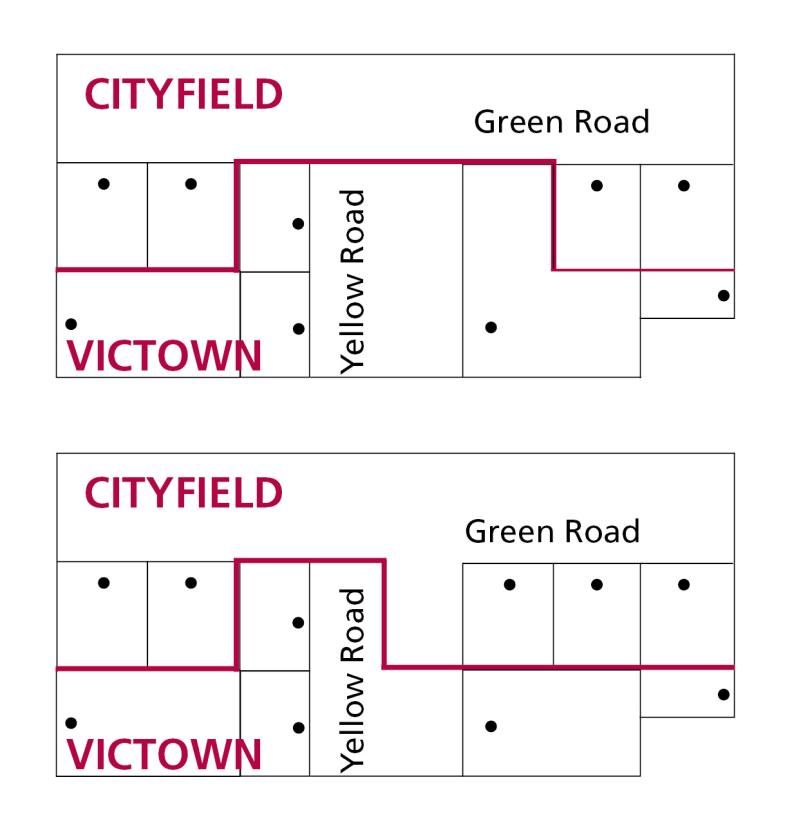
Step 1 Check information ............................................................................... 61
            Step 2 Apply the principles............................................................................. 61
            Step 3 Consult with Indigenous communities ................................................. 61
            Step 4 Consult with emergency response and other stakeholders ................. 61
            Step 5 Consult with the public ........................................................................ 62
            Step 6 Council consideration .......................................................................... 62
     4.2.3 Lodging a proposal with the Office of Geographic Names (OGN) ..................... 62
     4.2.4 Registrar’s consideration of proposal ................................................................ 63
     4.2.5 Gazettal of a proposal ....................................................................................... 63
     4.2.6 Registration and notification .............................................................................. 64
     4.2.7 Signage ............................................................................................................ 64
  4.3 Public roads coordinated by government departments or authorities .............. 64
    4.3.1 Guidelines for specific departments and authorities .......................................... 64
    4.3.2 How a proposal can be developed .................................................................... 64
    4.3.3 How to determine a name for a proposal .......................................................... 65
       (a) Developing a name in-house ............................................................................ 65
       (b) Developing a name through a public competition ............................................. 65
    4.3.4 Preparing a proposal ........................................................................................ 65
            Step 1 Apply the principles ............................................................................. 65
            Step 2 Consult with affected municipal council(s) ........................................... 65
            Step 3 Consult with Indigenous communities ................................................. 65
            Step 4 Consult with emergency response and other stakeholders ................. 66
            Step 5 Consult with the public ........................................................................ 66
    4.3.5 Contact the Registrar of Geographic Names ..................................................... 66
    4.3.6 Registrar’s consideration of a proposal ............................................................. 67
       (a) Registrar’s consideration of a proposal seeking endorsement .......................... 67
       (b) Registrar’s consideration of a proposal seeking referral to a Geographic Place
       Names Advisory Committee .................................................................................. 67
    4.3.7 Gazettal of a proposal ....................................................................................... 67
    4.3.8 Registration and notification .............................................................................. 68
    4.3.9 Signage ............................................................................................................ 68
  4.4 Roads located in residential or commercial subdivisions.................................. 68
    4.4.1 Who is responsible? ......................................................................................... 68
    4.4.2 What is the naming process? ............................................................................ 68
    4.4.3 How are subdivision road names entered into VICNAMES? ............................. 69
    4.4.4 Signage ............................................................................................................ 69
    4.4.5 What happens if a name is entered into VICNAMES and is later shown to be
    non-compliant? .......................................................................................................... 69
    4.4.6 Maintenance and responsibility ......................................................................... 69
  4.5 Private roads located on private property ........................................................... 70
    4.5.1 Who is responsible and why should these names be registered? ..................... 70
    4.5.2 What is the naming process? ............................................................................ 71
    4.5.3 How are private road names entered into VICNAMES? .................................... 71
    4.5.4 Gazettal ............................................................................................................ 72
    4.5.5 Signage ............................................................................................................ 72
    4.5.6 Maintenance and responsibility ......................................................................... 72
Appendix 1: Road types accepted for registration ....................................................... 73
  Culs-de-sac .................................................................................................................. 73
  Either culs-de-sac or open-ended roads ................................................................... 73
  Open-ended roads ....................................................................................................... 74
  Pedestrian only roads ................................................................................................. 75

                                                Guidelines for Geographic Names 2010 (Version 2 January 2013)
                                                                                                      Page v
Section 1: Purpose and Principles
1.1 What are these guidelines?
Anyone interested in the naming process, from a local resident or business owner to a
recreational park visitor or government employee, will find in these guidelines step-by-step
information on naming, renaming or changing the boundaries of features, localities and
roads in Victoria.

These guidelines are mandatory for naming authorities in Victoria. They have been
developed through detailed consultation with municipal councils, government departments
and emergency response and public service providers. The guidelines are based on
national standards and policies and provide a strong basis for standardised and
unambiguous naming procedures across the state.
These guidelines are provided for under s. 5 of the Geographic Place Names Act 1998 (the
Act) where it states that:
(1) The Governor in Council, on the recommendation of the Minister, by Order published in
    the Government Gazette, may make guidelines relating to procedures to be
    implemented in selecting, assigning or amending names of places.
(2) Without limiting the generality of subsection (1), the guidelines:
    (a) must set out the rules and process to be followed in selecting, assigning or
        amending a name of a place;
    (b) must set out the process to be followed before selecting or assigning an Aboriginal
        or Torres Strait Islander name of a place;
    (c) must specify criteria for the assessment of cultural heritage or other significance in
        relation to the naming of places;
    (d) must set out requirements for consultation before a name of a place is selected,
        assigned or amended; and
    (e) may specify any other matter or thing appropriate in relation to the naming of
        places.

These guidelines provide details on the Register of Geographic Names (VICNAMES) (refer
to Section 1.6), and also offer information on the role of the Minister responsible for the
Geographic Place Names Act 1998, the Registrar of Geographic Names, the Geographic
Place Names Advisory Panel and various naming authorities.

1.2 How do these guidelines work?
These guidelines are intended as an instructional guide to naming, renaming and adjusting
the boundaries of features, localities and roads in Victoria.

The information in this guide is divided into four main sections
Section 1: Purpose and Principles
Section 2: Features
Section 3: Localities
Section 4: Roads

Section 1 includes general information about the naming process and details the principles
applying to all cases of naming, renaming or changing the boundary of a feature, locality or
road. The information in Section 1 should be used in conjunction with the various principles
and procedures outlined in Sections 2, 3 and 4.

                                     Guidelines for Geographic Names 2010 (Version 2 October 2012
                                                                                          Page 1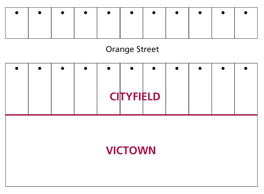
1.3 Why is there a need for these naming guidelines?
The use of consistent and accurate geographic names is important for a range of daily
activities. As the United Nations Group of Experts on Geographical Names (UNGEGN)
recognise:
‘Place names can identify and reflect culture, heritage and landscape. Correct use of
accurate place names can provide benefits to local, national and international communities
engaged in:
trade and commerce;
population censuses and statistics;
property rights and cadastre;
urban and regional planning;
environmental management;
emergency service response and natural disaster relief;
map and atlas production;
communications including postal and news services; and
navigation and tourism.’
These guidelines provide a structure for ensuring that assigning names to features,
localities and roads in Victoria is undertaken in a way that is beneficial to the long-term
interests of the community, for all of the reasons outlined by UNGEGN.
1.4 What can be named or renamed using these guidelines?
Any feature, locality or road (whether public or private) can be named, renamed or have its
boundary changed, using the principles and procedures of these guidelines. Compliance
with these guidelines is mandatory for all government-owned or administered features,
localities and roads, all topographical (natural) features of greater than local significance,
and private roads that are to be included in VICNAMES, the Register of Geographic
Names.
When a feature is not owned or maintained by a government department or authority (such
as cultural centres, wineries, sporting centres or homesteads) the owners are strongly
encouraged to adopt the principles of these guidelines in the naming process. To ensure
VICNAMES accurately reflects the status of named features in Victoria the names of these
privately owned features are recorded.
Because there are many different types of features in Victoria, the responsibility for
preparing naming proposals and submitting them to the Registrar can vary. Section 2 of
these guidelines provides details on the different naming processes for features.
Municipal councils are usually the naming authority for localities and further details can be
found in Section 3.
Information on the types of roads registered in VICNAMES is found in Section 4.
Guidelines for Geographic Names 2010 (Version 2 January 2013)
Page 2
1.5 Who can name or rename features, localities and roads in
Victoria, and who oversees the process?
Government departments and authorities maintain some of Victoria’s features, localities
and roads while others are developed and owned privately or by organisations. Following
are the three stages in the naming process for individuals or organisations.
Stage Who Can Do It Further Information
Who can propose Anyone (individuals, community groups, Section 1.5(a)
a new name? organisations, government departments or
Section 1.5(b)
authorities) can propose a new name,
Who can propose change to an existing name or boundary
a name change? change.
Who can propose
a boundary
change?
Who can develop Naming authorities are usually the municipal Section 1.5(c)
a naming, councils, government departments or
renaming or authorities who are responsible for
boundary change submitting a naming proposal to the
Registrar of Geographic Names.
proposal?
Details of authorities responsible for
developing naming proposals for features Section 2
are provided in Section 2.
For localities, the authority is usually the
municipal council(s) within which the locality Section 3
is situated. Further information is provided in
Section 3.
Information on authorities responsible for
road naming can be found at the beginning Section 4
of Section 4.
A Geographic Place Names Advisory
Committee can develop or review a naming
proposal if a feature, locality or road is
Section 1.5(f)
determined to have greater than local
significance. Further information is available
in Section 1.5(f)
Who has These include: Section 1.5(d)
authority to the Minister responsible for the
Geographic Place Names Act 1998; Section 1.5(e)
approve, defer or
reject naming The Registrar of Geographic Names; Section 1.5(f)
proposals for and
entry in Geographic Place Names Advisory
Panel and committees.
VICNAMES?
In addition, if during the course of
developing a naming proposal a naming
authority finds that it does not conform to the
principles of these guidelines, the naming
authority can decide to reject the proposal
and not submit it to the Registrar.
Guidelines for Geographic Names 2010 (Version 2 January 2013)
Page 3Diagram: People, organisations and processes involved in naming, renaming or
changing the boundary of a feature, locality or road
Guidelines for Geographic Names 2010 (Version 2 January 2013)
Page 4(a) Members of the public
Members of the public are welcome to participate in the naming process. They can do this
by submitting proposals to the relevant naming authority (refer to Section 1.5(c) for details)
for the feature, locality or road they are interested in adjusting the boundaries of, naming or
renaming. Further specific details of the naming proposal procedures, and the information
the public should provide in a submission to a naming authority, are outlined in the relevant
sections (features, localities, roads) of these guidelines.
Members of the public can also be involved by expressing to a naming authority any
support or objections to a naming proposal during the public consultation period. Details
are provided in Principle 1(M).
If a member of the public believes a naming authority erred in its decision to approve a
proposal that does not conform to these guidelines, an appeal can be submitted directly to
the Registrar for consideration and resolution. Further details on the objection process are
provided in Principle 1(N).
(b) Stakeholders
Stakeholders such as emergency response and other service providers are involved in the
naming process in three ways. They can:
propose a name or boundary for a feature, locality or road to the responsible naming
authority;
alert a naming authority and the Registrar to an issue with an existing name or
boundary for a feature, locality or road and request that the matter be investigated; and
assist the Registrar in determining whether a naming, renaming or boundary change
proposal conforms to these guidelines.
(c) Naming authorities
Due to the variety of features, localities and roads that can be named, there are multiple
types of naming authorities. Essentially, municipal councils, government departments or
authorities and private organisations are naming authorities when they are responsible for
developing naming proposals for the features, localities or roads within their jurisdiction.
This applies even when they might not be responsible for the maintenance and/or
ownership of the feature or road.
Details of which authorities are responsible for developing naming proposals for different
features are provided in Section 2.
For localities, the authority is the municipal council(s) within which the locality is situated
and details are provided in Section 3.
Information on authorities responsible for road naming can be found in Section 4.
(d) Minister responsible for the Geographic Place Names Act 1998
The Minister responsible for the Geographic Place Names Act 1998 appoints the Registrar
of Geographic Names (provided for under s. 7 of the Act) and members of the Geographic
Place Names Advisory Panel (provided for under s. 14 of the Act).
Section 11(5) of the Act provides that the Minister may direct the Registrar to enter
geographic names into VICNAMES, and under s. 12(1) of the Act may also direct the
Registrar to refer a naming matter to a committee for its advice.
For details on the Registrar and the Geographic Place Names Advisory Panel and
committees refer to subsections (e) and (f) below.
Guidelines for Geographic Names 2010 (Version 2 January 2013)
Page 5(e) Registrar of Geographic Names
The powers and functions of the Registrar (set out in s. 8 of the Act) include the power to
keep and maintain VICNAMES, the online Register of Geographic Names, and monitor and
review compliance with these guidelines.
The Registrar oversees the Office of Geographic Names (OGN), whose primary role is to
assist members of the public and naming authorities to develop robust naming proposals
for features, localities and roads.
The Registrar maintains VICNAMES in Victoria and enters and/or amends entries as
required by the Minister, Geographic Place Names Advisory Committees or naming
authorities.
The Registrar is also responsible for maintaining the Geographic Place Names Advisory
Panel appointed by the Minister and for allocating members of the panel to select
committees, as required from time to time by the Minister, or in instances of a naming
proposal being considered to be of greater than local significance (refer to Principle 1(G)).
For details on the Geographic Place Names Advisory Panel and committees refer to
subsection (f) below.
(f) Geographic Place Names Advisory Panel and committees
The appointment of members to a Geographic Place Names Advisory Panel and
procedures governing its processes and committees are outlined in s. 12 to s. 17 of the Act.
Information on why a committee may be convened and what it may consider are provided
below.
Reasons why a committee may be convened
Under s. 14(1) of the Act the Minister maintains the panel of people for appointment
as members of committees. These committees can be convened by the Registrar for
five reasons:
Under s. 12(1) of the Act the Minister directs the Registrar to convene a
committee for its advice on a naming proposal (or discrete set of proposals);
The Registrar determines that a naming proposal (or discrete set of proposals) is
of greater than local significance, and that a committee should be convened to
determine a decision on the proposal (see Principle 1(G)) for details of what is
considered to be of greater than local significance);
a naming authority determines that a proposal (or discrete set of proposals)
received within its jurisdiction requires the oversight and final decision to be made
by a committee;
the Minister, Registrar or a naming authority requires clarification or ratification of
a naming principle, policy or procedure; and
members of the public appeal a naming decision made by a naming authority
(submitted as a final proposal to the Registrar).
How a committee is convened
When convening a committee, the Registrar must (as provided under s. 12(3) of the
Act) appoint a chairperson and at least two other members. Committee quorum is
determined by the majority of member numbers (as provided under s. 16(2) of the
Act).
From time to time the Minister or Registrar might co-opt staff from relevant
organisations or government departments and authorities to be members of a select
committee. These members will be co-opted to provide assistance and advice to the
appointed panel members on the committee.
Guidelines for Geographic Names 2010 (Version 2 January 2013)
Page 6What a committee considers
Committees should undertake the following to consider a naming proposal; determine
the answer to a question of principles, policies or procedures; or review a proposal
from a naming authority:
determine whether the naming proposal in its current form conforms to all
required principles, policies and procedures of these guidelines;
seek further supporting evidence, if required, from the naming authority,
government departments or development bodies, and other interested parties
such as affected local land owners, businesses or residents;
consult with relevant emergency response or public service organisations if a
question of public safety or confusion might arise; and
consider all information for its relevance to the principles of the guidelines,
especially all objections received from members of the public and emergency
response or other public service organisations.
How a committee decides
To reach a final decision, a committee will determine the merits of the naming
proposal or identify issues arising from application of the current principles and
policies outlined in these guidelines. Based on this determination a committee will
provide advice to the Registrar that outlines how the naming proposal or clarification
of principles and policies should proceed.
When a committee is considering objections lodged by members of the public to a
proposal made by a naming authority, the committee will determine whether the
naming authority acted in accordance with these guidelines.
If it is determined that the naming authority acted in accordance with these guidelines
then the committee should recommend acceptance of the naming proposal.
If it is determined that the naming authority did not act in accordance with these
guidelines then the committee should provide recommendations on how to resolve
the issues.
Section 12(3) of the Act provides that the final decision on a question arising from a
meeting must be determined by three members or a majority of present members’
votes. If a committee vote is hung, the chair has the casting vote.
As provided under s. 13 of the Act, a committee must provide final advice to the
Registrar on a matter to which it has been referred. Under s. 11(3) of the Act the
Registrar must make entries or alterations to VICNAMES as advised by a committee.
Guidelines for Geographic Names 2010 (Version 2 January 2013)
Page 71.6 What are the Register of Geographic Names and VICNAMES?
Section 9 of the Act provides for a Register of Geographic Names, which includes place
names and the names of streets and roads (as provided under Part II of the Survey Co-
ordination Act 1958).
The Register of Geographic Names is an electronic system known as VICNAMES, which
can be accessed through the Internet at www.dse.vic.gov.au/vicnames.
Section 9(2) of the Act determines that the Register of Geographic Names can be kept in
whichever format the Registrar prefers.
VICNAMES stores information and data related to all officially registered and recorded
feature, locality and road names in Victoria. For each entry VICNAMES stores the following
information:
name;
historical name (if available);
history of the name (if available);
dual name (if relevant);
traditional name (if available);
status of name;
coordinates (centroid);
local government area where the feature is located;
naming authority;
gazette notice date; and
registration date.
VICNAMES is linked to Vicmap, the Victorian Government spatial data set. Linking
VICNAMES to Vicmap ensures that the information in VICNAMES is aligned to the spatial
representation of features, localities and roads, and that Vicmap contains reference to the
officially registered or recorded names for features, localities and roads.
Guidelines for Geographic Names 2010 (Version 2 January 2013)
Page 81.7 Status of names in VICNAMES
There are eight status categories applied to names in VICNAMES, the most common of
which are Registered and Recorded:
Place name status Description
This type is legally recognised for the purposes of the Act as an
Registered
official name for a feature, locality or road administered or
coordinated by a government authority.
Dual This type consists of one name comprised of one Indigenous
and one non-Indigenous name, which must be used together as
the registered legally recognised name for the feature (refer to
Principle 1(L)).
Historical This is a name that is no longer in official use but is recorded for
information purposes.
Base This is a lifetime name for a feature, if the recorded name is
subject to limited-term private contracts (refer to Principle 2(D)).
Recorded This is the name of a feature if a private entity has naming rights
(refer to Section 2.2).
Traditional This is a traditional Indigenous Australian name, which is not in
official use for a feature (refer to Section 2.5).
Interim A working title for a new school while the formal school naming
process is being undertaken.
Proposed New This is a new name for a feature, locality or road, which is
proposed but has not yet been approved by the Registrar.
Proposed Change This is a proposed new name for an already named feature,
locality or road, which has not yet been approved by the
Registrar.
Guidelines for Geographic Names 2010 (Version 2 January 2013)
Page 91.8 Principles
The following principles must be used in conjunction with the relevant specific
principles outlined in the three other sections of these guidelines relating to features,
localities and roads. They are designed to ensure that there can be no confusion, errors or
discrimination caused by the naming, renaming or boundary change process.
Principle 1(A) Language
Geographic names, except when they are proper nouns, must be written in standard
Australian English or a recognised format of an Australian Indigenous language local to
the area of the feature, locality or road.
Hyphens can be used within place names that indicate the extent of the feature
(Mellick-Munjie Parish or Hattah-Kulkyne National Park) or incorporate a hyphenated
surname (Baden-Powell Waterhole).
A generic term is a part of a place name that signifies the type of feature. For example,
‘Inlet’ in Shallow Inlet, ‘Desert in Little Desert and ‘Point’ in ‘Sandy Point’ (where ‘’Inlet’,
‘Little’ and ‘Sandy’ are, in contrast, specific terms). The appropriate generic term should
usually form part of the name of a geographical feature; although, not all names have a
generic, for example The Grampians. Names taken from languages that represent
geographical features generally use such generic terms and will be allowed, unless the
combination of the specific produces a duplication of sense.
Geographic names should be easy to pronounce, spell and write, and preferably not
exceed three words (including feature or road type) and/or 25 characters.
o An exception to this is in the use of Australian Indigenous languages when it is
accepted that traditional names appearing at first to be complex will, over time,
become familiar and easy to use within the community.
The term ‘The’ is not a suitable prefix in naming of any feature, locality or road.
¸
Diacritical marks (symbols such as ´, or ¯ ) will be omitted from names drawn from
languages that use such marks. For example, Cape Reamur (not Cape Réamur).
An apostrophe must be deleted from geographic names written with a final ’s, and the
possessive ’s should not be included in the first instance. For example, Wilsons
Promontory (not Wilson’s Promontory).
Abbreviations are not allowed. An exception applies to the use of the honorific Saint.
For example, Mount must be registered or recorded in full, but Saint can be recorded as
St if requested by the naming authority.
For the purposes of consistency, names starting with Mc or Mac must not have a space
included between the Mc or Mac and the rest of the name.
Principle 1(B) Recognising the public interest
Regard needs to be given to the long-term consequences and effects upon the wider
community of naming, renaming or adjusting the boundary of a feature, locality or road.
Changes to existing names or boundaries will affect not only the current community but
also future residents, businesses, property owners and visitors. Changes to existing names
and boundaries of localities and roads can affect emergency response zones, land titles
and addresses. A proposal will be registered only when the long-term benefits to the
community can be shown to outweigh any private or corporate interests, or short-term
effects.
Principle 1(C) Ensuring public safety
Geographic names and boundaries must not risk public and operational safety for
emergency response, or cause confusion for transport, communication and mail services.
Many emergency response and other public services (such as mail) are determined by
locality boundaries or road extents, and proposals must ensure that operations will not be
adversely affected.
Guidelines for Geographic Names 2010 (Version 2 January 2013)
Page 10For example, the boundary of a locality must be applied in a way that makes sense not only
for the local community, but also for visitors. Similarly, the extent of a road name should
ensure easy navigation for pedestrians and vehicles along the entire route from one end to
the other.
Principle 1(D) Ensuring names are not duplicated
Place names must not be duplicated. Duplicates are considered to be two (or more) names
within close proximity, and those which are identical or have similar spelling or
pronunciation. Examples of names which are similar and considered to be duplicates are
White, Whyte, Wite and Wiet.
Duplication is not allowed within the one locality or within the following distances:
metropolitan urban area, within 5 kilometres (a metropolitan urban area consists of a
city and its surrounding suburbs, for example Kensington in the City of Melbourne,
Northcote in the City of Darebin, Caroline Springs in the City of Melton and
Broadmeadows in the City of Hume);
regional urban area, within 15 kilometres (a regional urban area consists of a central
hub and its surrounding suburbs, for example Central Ballarat and Soldiers Hill in the
City of Ballarat, Ironbark in the City of Greater Bendigo and Bairnsdale in East
Gippsland Shire Council);
rural or remote area within 30 kilometres (a rural or remote area is an area located
outside of cities and towns, for example Nhill in West Wimmera Shire Council,
Youanmite in Moira Shire Council and Harrietville in Alpine Shire Council).
If a naming authority is uncertain of which classification to apply, it should contact the OGN
for advice. Alternatively, apply a cautionary approach when checking for duplication and
use the 30 kilometres radius search.
If a feature or road is located near a state boundary, care should also be taken to avoid
duplication with names in the other state according to the distances prescribed above.
When considering assignment of locality names, naming authorities should refer to Section
3: Localities; Principle 3(G) Locality names unique to Australia.
The VICNAMES website can be used to check for a duplicate feature, locality and road
names (refer to User Notes 1, 2 and 3 from the website www.dse.vic.gov.au/vicnames for
details).
Principle 1(E) Directional names to be avoided
Cardinal directions (north, south, east and west) must be avoided. A proposed name that
uses a cardinal direction to distinguish itself from another similar name is considered to be
a duplicate name. In these instances a different name should be chosen to allow for a clear
distinction between the two or more features, localities or roads.
An example of an unacceptable name is Smith Street being renamed Smith Street West
and Smith Street East – either one or both ends of the street must be renamed.
Guidelines for Geographic Names 2010 (Version 2 January 2013)
Page 11Principle 1(F) Assigning extent to a feature, locality or road
When a proposal to name a feature, locality or road is being developed the naming
authority must clearly define the area and/or extent to which the name will apply. At a
minimum, a proposal for a feature (excluding a waterway) must include the centroid
coordinates, a locality must include the polygon attributes and a road or waterway must
include the line details.
For example, the name of a road should apply from one end of the road to the other, i.e. to
the points where the road finishes or intersects with other roads.
The name of a waterway should apply from the beginning of the watercourse to its
confluence with another waterway or body.
Principle 1(G) Linking the name to the place
Place names should be relevant to the local area, with preference given to unofficial names
used by the local community. Infrastructure features should use the name of the locality.
For example, railway stations should be named after the locality in which the station is
located. Names of private estates should not be applied to features or localities to avoid
possible addressing issues in the future.
When a feature, locality or road is of greater than local significance the name should be
relevant to the wider community. A feature, locality or road considered of greater than local
significance will usually fall into one or more of the following categories:
it is located in two or more municipal areas;
it is located in a significant tourist precinct;
it is proposed to be created as part of a State or Federal Government project;
it is a major waterway;
it is a major undersea or shoreline feature;
it has major cultural, natural or recreational landscape features; and
it is linked to a significant Aboriginal feature, story or landscape.
In these instances a naming authority can request that the Registrar convenes a
Geographic Place Names Advisory Committee to develop or determine a decision on a
naming proposal. Refer to Section 1.5(f) for further details.
Principle 1(H) Using commemorative names
Naming often commemorates an event, person or place.
The names of people who are still alive should be avoided because community attitudes
and opinions can change over time.
A commemorative name applied to a locality or road should use only the surname of a
person, not a first or given names. A commemorative name applied to a feature can use
the first name and surname of a person; although, it is preferred that only the surname is
used.
The initials of a given name are not to be used in any instances.
This approach is to ensure that emergency and postal services are not delayed through
inconsistent application of the name. For example, a feature named Smith Park is easier to
identify than one named John Edward Smith Park if the possibility of John Park, Edward
Park, John Smith Park etc. could be used by the public.
Naming authorities should make every effort to gain consent from family members of the
person who is being commemorated. Supporting evidence that shows attempts by a
council to consult with family members should be provided to OGN during the lodgement of
the proposal.
Guidelines for Geographic Names 2010 (Version 2 January 2013)
Page 12You can also read