Geohealth Meets Geodesign: The Multidisciplinary Challenges of Informing the Regional Design Studio with Human Health Research - gis.Point
←
→
Page content transcription
If your browser does not render page correctly, please read the page content below
300                                                                                             Full Paper

Geohealth Meets Geodesign: The Multidisciplinary
Challenges of Informing the Regional Design Studio
with Human Health Research
David L. Tulloch, Ph. D.
Rutgers University, New Brunswick NJ/USA · tulluch@crssa.rutgers.edu

Abstract: The increasingly facile tools of geodesign create new opportunities for integrating the sci-
ences of human health into landscape interventions. This paper tests those opportunities using examples
from a series of graduate design studios as an investigation of ways that these fields can advance to-
gether. The paper concludes with a discussion of outcomes as well as implications for future efforts
integrating geohealth and geodesign.
Keywords: Geodesign, geohealth, human health, data-driven design, regional design

1      Introduction
While an appreciation of the linkages between landscape and human health may date back to
Dr. John Snow (BRODY et al. 2000) and Frederick Law Olmsted (FISHER 2010), a rapidly
expanding body of research now details many different ways that our environment shapes
our health (e. g., THOMPSON 2011). Landscape architecture has often successfully used park
design as its primary forum for shaping healthier environments, but the integration of sci-
ences like health and epidemiology support expansion of the design arena while bringing new
challenges for the designer.
One of the strengths often touted for geodesign is the ability to infuse the design process with
increased quantities of science and data, with the outcome of more informed designs. A chal-
lenge for institutionalizing geodesign is teaching design students to meaningfully integrate
science and data into the design process, while they are still learning to navigate the process.
This approach has a long tradition, as evidenced by McHarg’s use of the physical and social
sciences as integral components in studio education and his department. Two of the most
common procedural models for geodesign projects (STEINER 2008, STEINITZ 2012) both ex-
plicitly incorporate connections between foundational science and data and the resulting de-
sign work. They also both proscribe systematic approaches while conceding the need for
flexibility in those approaches.
The emergence of geodesign and similar tools opens the quite daunting possibility (perhaps
even expectation) of students accessing and building on sophisticated research from other
fields (DANGERMOND 2009, GOODCHILD 2010, FLAXMAN 2010). This integration across dis-
parate fields raises potential conflicts in methodology and outcomes. It also creates opportu-
nities for imaginative solutions and open conversations about conditions and problems that
are usually addressed in a more controlled and formulaic manner.
This paper reports on pedagogical experiences centred on bridging the gap between multi-
disciplinary research outcomes and landscape architectural design outcomes in a graduate
design studio. Specifically, the paper identifies lessons that can be applied beyond the class-
room to the growing realm of health applications in geodesign. While these examples are

Journal of Digital Landscape Architecture, 4-2019, pp. 300-307. © Wichmann Verlag, VDE VERLAG GMBH ·
Berlin · Offenbach. ISBN 978-3-87907-663-5, ISSN 2367-4253, e-ISSN 2511-624X, doi:10.14627/537663032
This article is an open access article distributed under the terms and conditions of the Creative Commons
Attribution license (http://creativecommons.org/licenses/by-nd/4.0/).
D. L. Tulloch: Geohealth Meets Geodesign                                                      301

student explorations, they serve as a reminder of the aspirational goals of geodesign in changed
landscapes for improving the overriding conditions for communities.

2     Studio Projects
The primary bases for this paper are the outcomes of a series of graduate regional design
studios which repeatedly partnered with county planning departments for semester-long ex-
plorations of potential county-wide approaches to healthier landscapes. The completed pro-
jects were expected to generate a variety of designed landscape alternatives that demonstrated
the potential for these counties to integrate research outcomes on human health into the pro-
cess.
Human health encompasses vast fields of study, and the projects did not initially restrict the
topical contents of the outcomes. Some of the health issues discussed are easily linked with
spatial outcomes, like the tick-borne Lyme disease that is plaguing the Northeast US. Other
health issues, such as influenza, did not seem as obviously linked with specific places in the
counties that were being studied. As the studio progressed, however, patterns of treatment
often emerged even if patterns of exposure or incidence were less explicit. Early in each
semester students were introduced to a variety of human health literature that explicitly con-
nects health outcomes to conditions of the built landscape (e. g., BURDETTE & WHITAKER
2004, THOMPSON 2011, COUTTS & HAHN 2015). They were also presented with research that
explicitly used GIS as a foundation of inquiry or for communication (e. g., OHRI-VACHAS-
PATI et al. 2013, TANG et al. 2014, CAVANAUGH, MIAL & TULLOCH 2016).

This paper is written with the intention of capturing larger experiences that might be gener-
alized to other studios, but it is worth noting a particular background condition that supported
the studios. At the time of the studios, the instructor had conducted several years of research
in human health with specialists from several health fields (including epidemiology, public
health, global surgery, psychology). However, the unique conditions of each county required
the instructor and students to all learn new topics quickly, with both substantial breadth and
depth. For example, one of the studios found an interview with County Chief Health Officer
to be particularly challenging, as he and his staff were concerned about a series of health
issues that were surprising to the group. Still, in each case the classes were able to follow a
systematic approach, translate issues into spatial representations, and develop strategies to
discuss further with the local authorities.

2.1   Informed Spatial Analysis
After an initial study of the study area, one of the early exercises for students is the incorpo-
ration of scientific research into spatial analysis. Set in a design studio, the results are often
more creative analyses than what might be expected in a straight-forward GIS and health
class. For example, mapping food outlets and buffering them becomes an illustration of “food
deserts”. The creation of simple buffered maps around health facilities often sparks new con-
versations, especially with health professionals from outside the studio. With this expanded
understand of the urban landscape, the students began to see “exercise deserts” and “emer-
gency care deserts” (Figure 1).
302 Journal of Digital Landscape Architecture · 4-2019
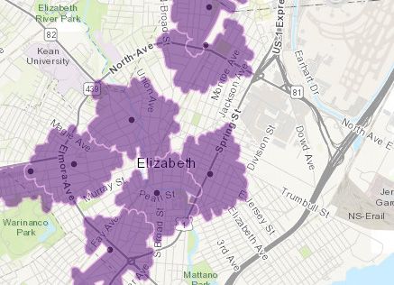
Recognizing the importance of the experience of the landscape, a second step is often the
creation of walking distance buffers rather than geometric circles (Figure 2). Building on the
traditions of Manning and McHarg, suitability analyses for multiple uses also emerge as tools
for the project. Even though they lacked the necessary sophistication with the tools, discus-
sions about how advanced technicians would map walkability across a large landscape en-
riched their critical thinking about the place. And student creativity often led to combinations
and overlays that forced new perspectives on the landscape (Figure 3). Simpler versions of
advanced analyses were still valuable as proxies for advanced research and stimulate class
discussions.
Fig. 1: Simple buffering of points (fitness centres and clubs) provides a powerful first look
at the landscape, especially as students are in early stages of learning geospatial
applications
2.2 Design Alternatives
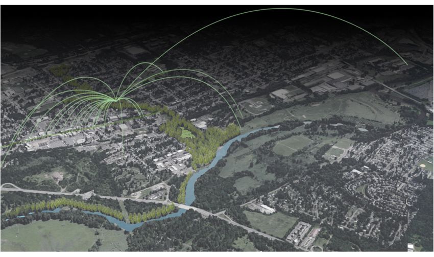
After a considerable period of developing spatial analyses, the studio challenged the students
asking them to derive alternative regional design solutions that are “proven” with site-spe-
cific design solutions (in the tradition of LEWIS 1996). The regional designs were expected
to serve as revelatory designs, revealing the landscape as seen through the earlier analyses
(Figure 4). While the nascent designers were not always able to fully realize that desired
outcome, their work did often demonstrate ways that it could fit larger contexts and relation-
ships landscape.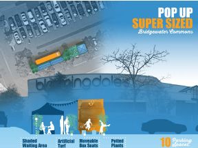
D. L. Tulloch: Geohealth Meets Geodesign 303
Fig. 2: Students created maps showing walking distance around supermarkets as a repre-
sentation of the food environment
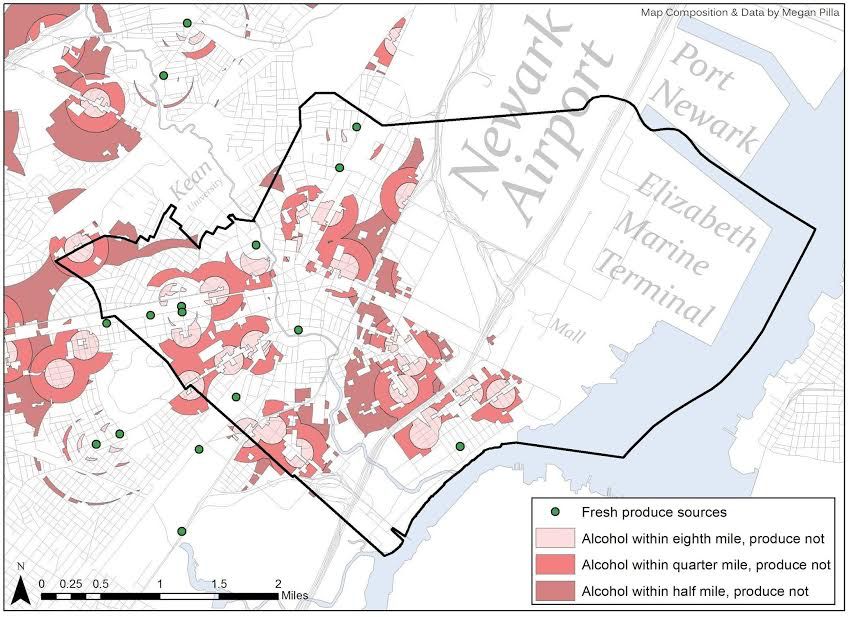
Fig. 3: Student spatial analysis of health conditions combined food desert mapping with
questions about availability of alcohol304 Journal of Digital Landscape Architecture · 4-2019
Fig. 4a & b: One student team endeavoured to improve access to healthier environments
at a county-wide scale, but designed at a local scale, in the regional design
tradition of Wisconsin Professor Phil Lewis (LEWIS 1996)
Fundamental to the exercise was a foundation in data-driven design and planning. When stu-
dents found themselves stymied or unable to generate new ideas they were encouraged to
return to the analyses and the data to ask what was needed. The repetition in outcomes sug-
gests a form of concurrent validity that makes generalizations from these experiences more
promising. The resulting designs showed some recurring themes that are worth mentioning:
Student design solutions repeatedly built on the sites of hospitals as multi-activity hubs
for access to multiple forms of health expertise, experience, and education.D. L. Tulloch: Geohealth Meets Geodesign 305
Reaching at-risk populations often featured guerrilla designs or pop-up solutions, which
challenged some assumptions and expectations about locations (Figure 5).
Strengthening the link between food and community, including filling in food access
gaps to reduce food deserts.
Designs were used to present other deserts – park, clinic, nature, physical activity.
Wellness became recognized through disparate perspectives as benefitting from inte-
grated approaches.
Fig. 5:
Students used design to explore adaptive
approaches to the landscape
An important result is that the studio was not stymied by difficulties in accessing the enor-
mous and difficult literature. While class conversations explored the way that science and
creativity could potentially conflict, the resulting designs displayed an open creativity while
confronting the limits of the science. This certainly suggests that the role for geodesign can
expand more into health and science areas. Initial responses to the design outcomes also sug-
gest that professionals in the fields found the creative work provocative in useful ways. Per-
haps just as intriguing are the unique individual design solutions which generated unexpected
discussions with the studio stakeholders.
3 Outcomes
Ultimately, there are several different obstacles to the integration of science and data into
informed designs. The science can be complex and hard to understand, requiring substantial
background knowledge. The results often don’t lend themselves to immediate spatial inter-
pretation. And the supporting documentation for scientific data can be poor, since it is often
developed for a small circle of users.
Despite these barriers, the paper identifies key outcomes that suggest that the informed design
project serves a substantive pedagogical purpose beyond the simple technical lessons and
skill building. The data-driven approach demands students respond to the entirety of a vast
landscape as it is described in the data, not simply as they imagine it after limited or con-
strained site visits. Turning to research papers and geospatial data forces the students to grap-
ple with an exceptionally challenging problem of whether to address the large volume of
information or to isolate a small portion and focus on a detailed response to that. Finally,306 Journal of Digital Landscape Architecture · 4-2019 using this approach reinforces Carl Steinitz’s longstanding call for the profession to step up and deliver defensible designs (STEINITZ 1979). Using design as a research tool in the studio is revelatory of the landscape, not just the pro- cess. While GIS is not as important for the students’ creative programming of pop-up health clinics and roof-top healing gardens, it forces a contextual awareness and their suitability analyses for a variety of health uses create a information resource about the landscapes of these counties. Clusters of opportunities repeatedly appeared in some areas, while other areas varied dramatically. Additionally, the response from the county planning offices demon- strated a newly heightened awareness of both the spatial patterns of need as well as landscape patterns that could potentially aid or impede interventions. Aside from the immediate pedagogical lessons, these projects point to larger concerns about geohealth and geodesign. One primary limitation of future work is the lack of a supporting health information infrastructure (RICHARDSON et al. 2013). In addition, scale remains an important dimension. Geohealth research has spanned a variety of scales, from neighbour- hood-scale impacts and interventions (DUNCAN et al. 2011, DEWEESE et al. 2013) to nation- wide analyses (KNOWLTON et al. 2017). For landscape architecture, balancing creativity and science remains a critical challenge. Simply following the science or mapping risks the cre- ation of soulless solutions that lack appeal and will fail to engage the public and generate healthier results. Creative geodesign applications will be key to making healthier landscapes both compelling and places of measurably increased wellness. Acknowledgments The author wishes to express special thanks to all of the students of Rutgers University grad- uate program in landscape architecture whose work in the geodesign studio has not only in- formed the communities of Middlesex and Somerset Counties, but has also been instructive to me as an educator. And a special thanks to students whose work was most helpful in illus- trating the projects for this paper: Thomas Young, Lungon Ju, Constatine Janulis, Andrew Schlesinger, and Megan Pilla. These studios also benefitted from critiques and comments of the county planning staffs, especially Nick Tufaro and Tara Kenyon. References BRODY, H., RIP, M. R., MINTEN-JOHANSEN, P., PANETH, N. & RACHMAN, S. (2000), Map- Making and Myth-Making in Broad Street: The London Cholera Epidemic, 1854. The Lancet, 356 (9223), 64-68. BURDETTE, H. L. & WHITAKER, R. C. (2004), Neighborhood Playgrounds, Fast Food Res- taurants, And Crime: Relationships to Overweight in Low-Income Preschool Children. Preventive Medicine, 38, 57-63. CAVANAUGH, C. E., MIAL, K. & TULLOCH, D. (2016), Assessing and Mapping the Availa- bility of the Female Condom in the Philadelphia Metropolitan Area. AIDS and Behavior, 20, 2845.
D. L. Tulloch: Geohealth Meets Geodesign                                               307

COUTTS, C. & HAHN, M. (2015), Green Infrastructure, Ecosystem Services, and Human
   Health. International Journal of Environmental Research and Public Health, 12 (8), 9768-
   9798.
DANGERMOND, J. (2009), GIS: Designing Our Future. ArcNews, 31 (2, Summer), 6-7.
DEWEESE, R., YEDIDIA, M. J., TULLOCH, D. & OHRI-VACHASPATI, P. (2013), Neighborhood
   Perceptions and Active School Commuting in Low-Income Cities. American Journal of
   Preventive Medicine, 45 (4): 393-400.
DUNCAN, D. T., ALDSTADT, J., WHALEN, J., MELLY, S. J. & GORTMAKER, S. L. (2011),
   Validation of Walk Score® For Estimating Neighborhood Walkability: An Analysis of
   Four US Metropolitan Areas. International Journal of Environmental Research and Public
   Health, 8 (11), 4160-4179.
FISHER, T. (2010), Frederick Law Olmsted and the Campaign for Public Health. Places Jour-
   nal, November. https://doi.org/10.22269/101115.
FLAXMAN, M. (2010), Geodesign: Fundamental Principles and Routes Forward. Talk at Geo-
   Design Summit 2010.
GOODCHILD, M. (2010), Towards Geodesign: Repurposing Cartography and GIS? Carto-
   graphic Perspectives, Special Digital, 2 (Fall), 7-23.
KNOWLTON, L. M., BANGUTI, P., CHACKUNGAL, S., CHANTHASIRI, T., CHAO, T. E., DAHN,
   B. & HENDEL, S. (2017), A Geospatial Evaluation of Timely Access to Surgical Care in
   Seven Countries. Bulletin of the World Health Organization, 95 (6), 437.
LEWIS, P. (1996), Tomorrow by Design: A Regional Design Process for Sustainability.
   Wiley, New York.
OHRI-VACHASPATI, P., LLOYD, K., DELEIA, D., TULLOCH, D., PETLICK, N., MARTINEZ, D.
   & YEDIDIA, M. (2013), A Closer Examination of Measures of Food and Physical Activity
   Environments as They Relate to Childhood Obesity. Preventive Medicine, 57, 162-167.
RICHARDSON, D. B., VOLKOW, N. D., KWAN, M. P., KAPLAN, R. M., GOODCHILD, M. F. &
   CROYLE, R. T. (2013), Spatial Turn in Health Research. Science, 339 (6126), 1390-1392.
STEINER, F. (2008), The Living Landscape: An Ecological Approach to Landscape Planning.
   Island Press.
STEINITZ, C. (1979), Defensible Processes for Regional Landscape Design. Landscape Ar-
   chitecture Technical Information Series, 2 (1). American Society of Landscape Archi-
   tects, Washington, D.C.
STEINITZ, C. (2012), A Framework for Geodesign: Changing Geography by Design. Esri
   Press, Redlands, California.
TANG, X., OHRI-VACHASPATI, P., ABBOTT, J. K., AGGARWAL, R., TULLOCH, D. & LLOYD,
   K. (2014), Associations between Food Environment around Schools and Professionally
   Measured Weight Status for Middle and High School Students. Childhood Obesity,
   10 (6), 511-517.
THOMPSON, C. W. (2011), Linking Landscape and Health: The Recurring Theme. Landscape
   and Urban Planning, 99 (3-4), 187-195.
You can also read