GOING THE DISTANCE: TRANSPORTATION MOBILITY IN THE NEW YORK METROPOLITAN REGION - October 2009 - Permanent Citizens Advisory Committee to the MTA
←
→
Page content transcription
If your browser does not render page correctly, please read the page content below
GOING THE DISTANCE:
  TRANSPORTATION MOBILITY IN THE NEW YORK METROPOLITAN REGION

October 2009
Going the Distance — Transportation Mobility in the NY Metro Region                   October 2009

Executive Summary
The Permanent Citizens Advisory Committee (PCAC) to the Metropolitan
Transportation Authority (MTA) represents the interests of the riders of the
nation's largest public transportation system. PCAC is comprised of three rider
councils: the Long Island Rail Road Commuter's Council (LIRRCC); the Metro-
North Railroad Commuter Council (MNRCC); and, the New York City Transit
Riders Council (NYCTRC). These councils, created by the New York State
(NYS) legislature in 1981, are comprised of volunteer members who are
recommended by local officials and appointed by the Governor.

One of the long-standing activities of the PCAC is providing timely research on
issues relevant to riders. Our current investigation arises from a concern about
the slow advancement of the MTA's smart card initiative — Smartcard
Demonstration Project Phase I — and the desire for a status report on fare
integration and connecting transit service across the region. PCAC had looked
at the potential of automated fare policy at MTA in 2004 (In your Pocket: Using
Smart Cards for Seamless Travel). In that study PCAC not only recommended
that MTA make smart card a priority, but, "should also maintain regular contact
with the Port Authority of New York and New Jersey (PANYNJ), NJ TRANSIT
and Regional Interoperability Standard working groups to ensure that MTA smart
card strategies are consistent with those planned for other regional transportation
systems." However, since that report was written interoperability has become
more than just fare convenience; it now includes physical and informational
integration as well.

The Region
The NY Metro region is defined by the Census, based on commuting ties and
social and economic integration with the New York City (NYC) core, as the New
York-Newark-Bridgeport, NY-NJ-CT-PA Combined Statistical Area (30 counties).

The Agencies
The key transportation entities are: MTA, NJ TRANSIT, PATH/PANYNJ, Amtrak,
Bee-Line Bus, Suffolk County Transit and several ferry services. Commuter rail
is focused into NY Penn Station and Grand Central Terminal (GCT); the majority
of the commuter bus traffic comes through the Lincoln Tunnel into the mid-town
Port Authority Bus Terminal (PABT) or across the George Washington Bridge
into the Port Authority’s George Washington Bridge Bus Station (GWBBS) in
Washington Heights, Upper Manhattan.

Service Integration

Choke Points
According to the MTA’s recently released Twenty Year Capital Needs
Assessment 2010–2029, many areas in the Tri-state region are currently
experiencing choke points due to the tremendous ridership increases that have

                        The Permanent Citizens Advisory Committee to the MTA (PCAC)
                                        347 Madison Ave., NY, NY 10017                           i
Going the Distance — Transportation Mobility in the NY Metro Region                   October 2009

occurred between 1990 and 2008: “During this time MTA ridership on all modes
increased 55%.” These existing choke points will become even more stressed
as the forecasts predict that the MTA’s annual ridership will grow from its current
level of approximately 2.5 billion to almost 3 billion by 2030.

The complexity of travel patterns are also impacting the choke points as riders
are no longer just geared to moving toward the city center during the morning
peak and away during the evening peak. As Metro-North Railroad (MNR) has
experienced, more of their ridership now travels off-peak, reverse peak and intra-
county. Thus, choke points need to be addressed in a multi-directional manner.

Mega-Projects
Several regional projects are underway to address these choke points with
assistance from the Federal Transit Administration (FTA):
 • NJ TRANSIT’s Access to the Region’s Core (ARC) project will double its rail
   capacity into NYC by adding two additional tunnels under the Hudson River
   which will connect to a new mid-town Manhattan terminal under 34th Street.
 • The MTA/Long Island Rail Road’s (LIRR) East Side Access project (ESA),
   utilizing an existing unused tunnel under the East River and building a new
   tunnel under Park Avenue, will double the capacity to the Core by bringing up
   to half of the LIRR trains into a new terminal under GCT.
 • A concurrent MTA project, the new Second Avenue subway will divert as
   many as 213,000 daily riders from the swamped Lexington Avenue Line, the
   nation’s busiest and most overcrowded subway.

Key Choke Points Currently Not Addressed
Despite the magnitude and importance of the ARC and ESA projects for
improving the “interoperability” of the region’s transportation, there are still many
bottlenecks that have yet to be addressed. Some of the barriers are physical,
some are financial and some are political or the lack of willingness to collaborate.

New York City
• The Queens Boulevard subway corridor (E/F/R/V) and the Flushing 7 line, the
  two primary transit arteries in Queens, are at capacity with more congestion
  forecast due to anticipated population and employment growth in the Borough.
• A link that will not happen as part of ARC, at least not for a while, will be that
  between NY Penn Station and GCT. The two commuter rail terminals are
  located more than a mile’s walk apart. This creates inconvenience in making
  transfers between MNR lines, other commuter rail lines and Amtrak.

 Long Island
• The most immediate choke point on Long Island is the LIRR’s main trunk line
  where four branches feed into two tracks. This causes both tracks to be used

                        The Permanent Citizens Advisory Committee to the MTA (PCAC)
                                        347 Madison Ave., NY, NY 10017                          ii
Going the Distance — Transportation Mobility in the NY Metro Region October 2009
in the inbound direction during the morning peak and the outbound direction in
the evening peak.
• Long Island also suffers from a choke point further out on the Main Line
Corridor where there is only a single track between Ronkonkoma (the LIRR’s
busiest station after Jamaica and Penn) to Farmingdale. The single track
again only allows for peak direction travel.
Staten Island
• The Staten Island West Shore travel corridor (Bayonne Bridge to the Staten
Island Railway at Richmond Valley between the Arthur Kill and Richmond
Avenue) presents significant obstacles to accessibility for travel on and off the
island, including very long travel times and incomplete geographic coverage to
areas of potential development.
Northern Counties in the MNR Region
• MNR runs two rail lines on the West Side of the Hudson River (Pascack Valley
and Port Jervis) through a contract service with NJ TRANSIT. These two lines
are single track, which precludes additional service as ridership climbs.
• The Tappan Zee Bridge, slated to be replaced with the ability to carry heavy
rail, is a major car/bus choke point.
Progress in Service Integration
Recognition should be given to some small but promising initiatives in service
integration: This fall (2009) MNR and NJ TRANSIT are providing joint service
from Connecticut on MNR’s New Haven Line, through Manhattan’s Penn Station,
to NJ TRANSIT’s Northeast Corridor Secaucus Station. There, riders transfer to
the new Meadowlands Rail Line to complete their journey to select Sunday
football game service for Giants and Jets fans.
Also, in a long needed move, MTA/New York City Transit (NYCT) initiated
integrated bus service from Staten Island to the HBLR 34th Street Station in
Bayonne, New Jersey in 2007. The new limited stop route (S89) allows Staten
Island residents to quickly reach the growing job market in Bayonne, Jersey City
and Hoboken, as well as connect with the PATH train to Manhattan.
Recommendations for Service Integration
The following are recommendations to further advance mobility in the region:
Rail
• MTA should support and work for more inter-jurisdictional and inter-agency
service across the region.
• MTA should continue to support and fund rail projects that remove “choke
points” such as those on the LIRR Main Line Corridor, Port Jervis Line, and
MNR service to NY Penn Station.
The Permanent Citizens Advisory Committee to the MTA (PCAC)
347 Madison Ave., NY, NY 10017 iiiGoing the Distance — Transportation Mobility in the NY Metro Region October 2009
Bus
• MTA/NYCT should continue to work with NYCDOT on developing more Bus
Rapid Transit (BRT) routes, particularly in areas such as Queens Boulevard
and Staten Island.
• MTA should strongly press for more financial support for Long Island Bus (LIB)
to greatly expand intra-island service, including BRT corridors to provide more
north-south transit opportunities.
• MTA/NYCT should explore the possibility of developing BRT or express bus
service from Queens and Brooklyn to the job centers in Nassau and Suffolk
Counties.
• MTA/NYCT should support the suggestions and work as needed with the
PANYNJ to achieve implementation of the recommendations of the Tri-State
Transportation Campaign (TSTC) in their May 2009 report, “Express Route to
Better Bus Service”. Most of these recommendations relate to the
improvement of the PANYNJ’s two bus terminals, the Express Bus Lane (XBL)
through the Lincoln Tunnel and bus loading and parking on the NYC streets.
Accessibility
• Across all modes and all agencies in the region there must be consistent and
compatible ADA compliance. Travelers with physical disabilities, particularly
those who use wheelchairs, have the biggest challenge in negotiating transfer
points and different systems.
Seven Day Service
• All agencies must work to provide robust weekend service so that the use of
public transportation will be attractive to travelers of discretionary trips. One of
the biggest barriers to interoperability is that weekend services are greatly
reduced across all systems. And yet, that is when a large number of people
travel for personal or recreational purposes and are most in need of a well-
integrated system. Currently, weekend service in some places doesn’t exist or
is much less frequent; express service is eliminated and only local routes or
trains operate; often there is a change in route patterns making connections
more difficult, frequently with large wait times. Further, track work on the
railroads and subways are often done on weekends and thus cause diversions,
detours or cancellation of the already limited scheduled service. And, worst of
all, the lack of good weekend service makes it easy to rationalize the use of the
car.
Fare Integration
Similar to the physical layout of a system, a region’s fare policy also influences
speed and convenience for transit riders. “Smart cards” decrease boarding times
because the rider can just wave it past the reader, generally without the need to
even remove the card from a wallet or handbag. They also allow riders to refill
funds online.
The Permanent Citizens Advisory Committee to the MTA (PCAC)
347 Madison Ave., NY, NY 10017 ivGoing the Distance — Transportation Mobility in the NY Metro Region October 2009
As a model for MTA smart card efforts, the 2004 PCAC report discussed the
efforts in implementing smart cards on PATH and three other cities’ transit
systems: Chicago (CTA), Washington, DC (WMATA) and the San Francisco Bay
Area (BART, AC Transit, Muni, Caltrain, etc.). Five years later, it has become
evident that the ease of transition into a smart card system is heavily dependent
on the willingness of all major regional transit entities to cooperate, and how
strictly the leading agency sticks to its pilot program and implementation timeline.
PATH and the other agencies have made significant progress in utilizing smart
card technology since 2004. MTA, however, which had no program in 2004, has
encountered widespread difficulties in adopting a smart card system. NYCT has
just finished the first phase of a smart card pilot program that began in 2006.
The program — Smartcard Demonstration Project Phase I — catered exclusively
to Citibank customers with MasterCard PayPass credit cards, debit cards, and
key fobs, allowing them to wave their card in front of a contactless sensor at
turnstiles on the Lexington Avenue subway line to make fare payments. While
marketing only to customers of one bank, and involving only one subway line, the
program was small, but showed potential.
By the end of 2009, MTA/NYCT hopes to begin a second phase of the pilot,
which will involve holders of credit cards from various banks. The program will
also involve several Manhattan bus lines, in addition to the Lexington Avenue
subway line, to observe the program’s ability to incorporate transfers. There will
also be an effort to incorporate other types of fares such as senior/disabled
reduced payments.
Recommendations for Fare Integration
• MTA must make a strong, sustained effort to not only expeditiously implement
a “smart card” form of payment, but to push for a format that allows riders to
move seamlessly across agencies and modes in the Region, i.e., a transit
riders’ “E-Z Pass”.
• The MTA should establish a working group of internal staff and external
advisors who will be tasked with monitoring the Smartcard Demonstration
Project.
• MTA should also begin planning for a smart card pilot program involving MNR
and LIRR. With a combined annual ridership of more than 170 million, and
with many New York commuters transferring each day between the rail lines
and bus or subway services, MNR and LIRR should be critical components of
smart card integration.
• MTA should expand the concept of the CityTicket (weekend use of LIRR and
MNR within NYC for a reduced price) to include late nights and morning
hours, and work with NYC to create and fund a “Freedom Ticket” (fixed price
travel on any MTA facility within a fare zone.)
The Permanent Citizens Advisory Committee to the MTA (PCAC)
347 Madison Ave., NY, NY 10017 vGoing the Distance — Transportation Mobility in the NY Metro Region October 2009
• LIRR should work with the PANYNJ to offer a combined single ticket for
Jamaica Station and the JFK AirTrain that can be purchased in ticket
machines.
• A MetroCard ticket machine and fare information should be readily available
to passengers exiting any terminal at JFK or LaGuardia Airports where buses
stop.
Unified Transportation Information
Another piece of the regional mobility puzzle is the access to comprehensive,
easily understandable, accurate and timely travel information. There are many
ways to access information and retrieving it should be as convenient as possible,
especially if someone is unfamiliar with the NY Metro Region. Current resources
are: MTA Trip Planner; 511NY that allows a person to obtain information about
travel within New York State; and travel alert links for MTA services, NJ
TRANSIT, PATH and the Port Authority Bridges and Tunnels.
It is also important to remember that there are still people who do not have a
computer or handheld devices that have internet access. Therefore, it is
extremely important that NJ TRANSIT, LIRR and MNR list in their printed
materials the telephone travel information numbers for connecting transportation
agencies.
LIRR, MNR, NYCT and NJ TRANSIT also have travel information centers where
one can call to obtain transit information and directions. However, none of these
information centers are open 24 hours a day, seven days a week.
Recommendations for Unified Transportation Information
There is no question that regional travel information is available but making sure
it is correct, consistent and accessible is the challenge at hand. To address
these problems we make the following recommendations:
• Enhance and increase communication between all the transit agencies in the
region and share information on an on-going basis to ensure that travel
information is accurate and timely.
• Improve web travel planner programs to provide the most efficient trips,
including routes where short walks between modes can shorten travel times.
• Create web travel planner programs that are specifically designed for travelers
that have special ambulatory needs or need wheelchair access, and are
available in formats for those with low vision.
• Make travel planning information accessible to mobile electronic devices.
• Reduce the telephone numbers needed to get travel information.
• Consider providing internet-based travel information kiosks at high volume
stations so that riders can have access to travel information at all times.
The Permanent Citizens Advisory Committee to the MTA (PCAC)
347 Madison Ave., NY, NY 10017 viGoing the Distance — Transportation Mobility in the NY Metro Region October 2009
• Move to standardize wayfinding signage across all transportation agencies in
the New York Metro Region.
• Provide adequate accessible wayfinding signage.
The Permanent Citizens Advisory Committee to the MTA (PCAC)
347 Madison Ave., NY, NY 10017 viiGoing the Distance — Transportation Mobility in the NY Metro Region October 2009
Acknowledgements
This report could not have been possible without the tireless efforts of a large
number of people who shared their knowledge, insights and first-hand
experiences. The work and time given to this undertaking by Graduate Research
Assistant, Chris Jewett, who is currently in a joint Masters student in the Urban
Planning-Law degree program at Rutgers University, was monumental. Also,
this report was enhanced greatly by the creative work of Manzell Blakely,
PCAC’s other Graduate Assistant who is in a Masters student in the Urban
Planning Program at the Bloustein School at Rutgers University specializing in
transportation.
We would also like to recognize PCAC members Ira R. Greenberg (LIRRCC),
Edith M. Prentiss (NYCTRC) and MNRCC nominee Randy Glucksman who
provided input and editorial comment that helped shape the report,
Special thanks go to Steve Frazzini and Paul Korczak of MTA/NYC Transit who
were invaluable resources on smart card issues; and Kim Porcelain at Metro-
North Railroad, who shared the railroad’s experiences with hand-held ticketing
procedures.
The input from staff at the other transit agencies we spoke to were incredibly
helpful and provided a wealth of information for this report. We would like to
thank them and greatly appreciate the time they spent sharing their experiences
with us: Jacob Avidon (MTC, San Francisco), Rose Poblete and Carol Walb (Bay
Area Rapid Transit), Michelle Goldberg (Chicago Transit Authority), J.C. Vanetta
and Joe Moriardi (Regional Transit Authority, Chicago), Thomas Harrington,
Cyndi Zieman and Lorraine Taylor (Washington Metropolitan Area Transportation
Authority), Nancy Noonan (Maryland Transit Administration), Matt Baratz, Henry
Rosen and Nuri Hamidi (Port Authority of New York and New Jersey), and Vivian
Baker (NJ TRANSIT).
Finally, a robust thank you goes to Jan Wells, PCAC Associate Director, for her
countless hours of editorial work and report development. We also want to
recognize the significant collaboration on this report by the other PCAC staff
members: William Henderson, Executive Director, Ellyn Shannon, Transportation
Planner, Karyl Berger, Research Associate and Deborah Morrison,
Administrative Assistant.
The Permanent Citizens Advisory Committee to the MTA (PCAC)
347 Madison Ave., NY, NY 10017 viiiGoing the Distance — Transportation Mobility in the NY Metro Region October 2009
Table of Contents
Executive Summary............................................................................................. i
Acknowledgements ..........................................................................................viii
List of Tables and Exhibits ................................................................................ x
Introduction .........................................................................................................1
The NY Metro Region
Geography ....................................................................................................... 4
Transportation Agencies .................................................................................. 6
Regional Service Integration
Commuter Rail Connections to the Core ......................................................... 9
Commuter Bus Connections to the Core ....................................................... 12
Transit Access within NYC............................................................................. 15
Long Island Intra-island Mobility..................................................................... 18
Choke Points/Missing Links ........................................................................... 18
Findings and Recommendations.................................................................... 23
Regional Fare Integration................................................................................. 24
Smart Card Background ................................................................................ 25
PCAC 2004 Report Update............................................................................ 26
MTA Progress ................................................................................................ 31
Findings and Recommendations.................................................................... 34
Regional Transportation Information.............................................................. 36
Current Sources for Travel Information
Web ........................................................................................................... 36
Print ........................................................................................................... 37
Signage...................................................................................................... 37
Findings and Recommendations.................................................................... 38
References ........................................................................................................ 39
Appendices
Appendix A — Transportation Agencies ........................................................ 43
Appendix B — TSTC Bus Recommendations................................................ 54
Glossary of Terms ............................................................................................ 56
The Permanent Citizens Advisory Committee to the MTA (PCAC)
347 Madison Ave., NY, NY 10017 ixGoing the Distance — Transportation Mobility in the NY Metro Region October 2009
List of Tables and Exhibits
Tables
Table 1 — MTA Totals at a Glance...................................................................6
Table 2 — Status of Smart Card Initiatives .....................................................32
Table 3 — New York City Transit at a Glance ................................................44
Table 4 — Staten Island Railway ....................................................................44
Table 5 — MTA Bus at a Glance ....................................................................45
Table 6 — Long Island Bus at a Glance .........................................................45
Table 7 — Long Island Rail Road at a Glance................................................46
Table 8 — Metro-North Railroad at a Glance..................................................47
Table 9 — NJ TRANSIT..................................................................................48
Exhibits
Exhibit 1 — Map of NY Metro Region ...............................................................5
Exhibit 2 — Map of Amtrak Route in NY Metro Region.....................................7
Exhibit 3A — Map of Rail Access to the Core: Tunnels ..................................10
Exhibit 3B — Map of Rail Access to the Core: Bridges...................................11
Exhibit 4A — Map of Commuter Bus Access to the Core: Hudson River........13
Exhibit 4B — Map of Commuter Bus Access to the Core: Staten Island ........14
Exhibit 5A — Map of Subway Bridges and Tunnels: East River .....................15
Exhibit 5B — Map of Subway Bridges and Tunnels: Harlem River .................16
Exhibit 5C — Map of Subway Bridges and Tunnels: The Rockaways ............16
Exhibit 6A — Map of NYCT Bus Bridges and Tunnels:
East and Harlem Rivers ..........................................................17
Exhibit 6B — Map of NYCT Bus Bridges and Tunnels:
Brooklyn and Staten Island .......................................................17
The Permanent Citizens Advisory Committee to the MTA (PCAC)
347 Madison Ave., NY, NY 10017 xGoing the Distance — Transportation Mobility in the NY Metro Region October 2009
Introduction
The Permanent Citizens Advisory Committee (PCAC) to the Metropolitan
Transportation Authority (MTA) represents the interests of the riders of the
nation's largest public transportation system. PCAC is comprised of three rider
Councils: the Long Island Rail Road Commuter's Council (LIRRCC); the Metro-
North Railroad Commuter Council (MNRCC); and, the New York City Transit
Riders Council (NYCTRC). These councils, created by the New York State
(NYS) legislature in 1981, 1 are comprised of volunteer members who are
recommended by local officials and appointed by the Governor.
One of the long-standing activities of the PCAC is providing timely research on
issues relevant to riders. The selected topics are approved by the members, the
most recent being ADA issues. 2 Our current investigation arises from a concern
about the slow advancement of the MTA's smart card initiative and the desire for
a status report on connecting transit service across the region. PCAC had
looked at the potential of automated fare policy at MTA in their 2004 report, In
your Pocket: Using Smart Cards for Seamless Travel 3 . In that study, PCAC not
only recommended that MTA make smart card a priority, but, "should also
maintain regular contact with the Port Authority of New York and New Jersey
(PANYNJ), NJ TRANSIT and Regional Interoperability Standard working groups 4
to ensure that MTA smart card strategies are consistent with those planned for
other regional transportation systems." 5 However, since that report was written
interoperability has become more than just fare convenience; it now includes
physical and informational integration as well.
In March of 2008, then Executive Director Lee Sander gave a State of the MTA
address on the occasion of the MTA’s 40th anniversary. He put considerable
emphasis on the growing potential for seamless regional mobility. He called for
“regional rail interoperability” and cited the growing interest in better West of
Hudson and cross-Westchester County accessibility, proposed new airport
connections, implementation of regional ticketing and a one fare media. "We
have embraced the concept of breaking down institutional and political
1
PCAC functions as the funding and staffing mechanism for the three councils and operates
under a memorandum of understanding with the MTA. In the NYS legislation (S5451/A8180)
passed May 7, 2009 that provides additional funding for MTA operations, the PCAC was given
statutory standing and its members defined as those of the three rider councils.
2
Welcome Aboard: Accessibility at the MTA (October 2008). http://www.pcac.org/wp-
content/reports/2008_ADA_accessibility.pdf
3
See http://www.pcac.org/wp-content/reports/2004_Smart_Cards.pdf. PCAC also looked at
shuttle services to train stations in a 2002 report, You’ve Got Connections. See
http://www.pcac.org/wp-content/reports/2002_Connections.pdf
4
In 2004, the Regional Interoperability Standards for Electronic Fare Payment initiative was an
attempt to move the industry away from the use of proprietary fare collection systems. These
standards had been accepted as the basis for national fare collection standards then being
developed by the American Public Transit Association (APTA), p.4.
5
Executive Summary, p. vii.
The Permanent Citizens Advisory Committee to the MTA (PCAC)
347 Madison Ave., NY, NY 10017 1Going the Distance — Transportation Mobility in the NY Metro Region October 2009
boundaries to improve service." He noted the success of the New York City
Transit (NYCT) S89 buses that now travel to Bayonne, New Jersey so that
passengers can connect with NJ TRANSIT's Hudson-Bergen Light Rail line
(HBLR) to access destinations on the New Jersey Gold Coast or travel into
Manhattan via the PATH (Port Authority Trans-Hudson) trains. Ridership gains
were so great that NYCT had to add three daily round trips.
Mr. Sander emphasized how much better travel is becoming for riders even
within the MTA system. He cited the impacts of current major construction
projects: "The benefits of these ongoing mega-projects are familiar to many of
you. What is not well understood is the way in which East Side Access and the
Second Avenue Subway will unlock the potential of the MTA network in Brooklyn,
Queens, and the Bronx, in addition to Manhattan." He explained that when the
East Side Access project is completed Long Island Rail Road (LIRR) riders will
have the option of traveling directly to Manhattan's east side via Grand Central
Terminal (GCT); and employment on Long Island will become more attractive as
a result of an improved reverse commute. In addition, Metro-North Railroad
(MNR) will then be able to boost service by going into freed-up space at Penn
Station and also by adding stations at Co-op City, Parkchester, and Hunts Point.
This will mean faster Manhattan-bound service and better service for those
traveling north to Westchester for jobs. The Second Avenue Subway, in addition
to relieving overcrowding on the Lexington Avenue line, will act as a trunk line for
new service to West Harlem, Brooklyn, Queens, and the Bronx. Sander pointed
out the opportunities that will be created with a new Tappan Zee Bridge: transit
capacity (train or bus rapid transit) across the bridge would provide direct travel
from West-of-Hudson counties of Orange and Rockland to a connection with the
MNR Hudson line as well as to the business centers in White Plains, Stamford,
and Greenwich. He also mentioned that MTA is working with NJ TRANSIT and
Amtrak to create regional commuter rail interoperability whereby routes are being
identified for running MNR service to New Jersey and Long Island.
To be sure, Sander is not the first at MTA to advance regional mobility. Fifteen
years ago MTA Chairman Peter Stangl pushed the "Fare Deal" program, as
described in the MTA’s 1994 Annual Report:
Fare Deal is the MTA's commitment to create a customer-friendly,
integrated regional transportation network that improves mobility and the
quality of life for metropolitan New York. It was created in 1992, endorsed
by the state legislature in 1993, and fully funded in 1994.
Under Fare Deal MTA launched MetroCard, its first automated fare card. The
Annual Report notes some important outcomes from this initiative:
Introducing MetroCard ... called for close collaboration between the MTA
Card Company (MTACC), NYC Transit, and MTA Headquarters. ...
The Permanent Citizens Advisory Committee to the MTA (PCAC)
347 Madison Ave., NY, NY 10017 2Going the Distance — Transportation Mobility in the NY Metro Region October 2009
MTACC also worked with the LIRR and Metro-North to initiate MetroCard
sales at ticket offices in the railroads' service areas. By requiring three
kinds of ongoing working relationships among the MTA agencies,
MetroCard is helping to advance a corporate culture that will support the
further integration of our services. MetroCard makes it possible to price
those services creatively and to allow our customers to travel on an MTA
commuter railroad and city subways and buses with just one card in their
pockets.
Along with an improved fare policy, a top priority under Fare Deal was the Capital
Program and future infrastructure investment needs. It is revealing to read the
following in the 1994 Annual Report and reflect on Sanders' presentation:
During the year we also made steady progress on the Long-Range
Planning Framework, under which MTA agencies are studying various
ways of expanding the regional rail network. Through this process, the
MTA will be able to choose projects that improve regional mobility in the
most cost-effective manner. Proposals studied in 1994 included bringing
the LIRR to the East side of Manhattan, constructing the Second Ave.
subway, utilizing Long Island City's intermodal connections, creating a
new NYC Transit Brooklyn-to-Manhattan crossing, establishing direct rail
service to Orange and Rockland counties, and building a rail link between
western Queens, midtown Manhattan and New Jersey.
From this look back, it is clear that there has been a historic desire for
interoperability for over a decade. And, although transportation agencies in the
New York metropolitan region have been moving toward cooperation and
integration of services, it has been at a painfully slow pace. The reasons vary
and often are a combination of obstacles: lack of leadership or change in
leadership at the agency, state or federal level; bureaucratic inertia; more
pressing priorities; unforeseen events (9/11); technology challenges; and,
inevitably, lack of funding resources. As a result, this paper not only describes
the progress that has been made in providing a more seamless ride throughout
the region, but it presses the MTA to move ahead expeditiously in fostering
service, fare and travel information integration. This is particularly timely in light
of the recently (June 18, 2009) proposed Surface Transportation Authorization
Act of 2009 proposed by the U.S. House of Representatives Committee on
Transportation and Infrastructure. This bill contains provisions for an expanded
metropolitan mobility and access program to "provide funding for congestion
relief plans designed to increase mobility and accessibility of people and freight
in major metropolitan areas." There is also an emphasis on intermodalism to
combat historic policies that "focus on individual modes of travel, rather than
considering the transportation needs of an interconnected intermodal system."
The Permanent Citizens Advisory Committee to the MTA (PCAC)
347 Madison Ave., NY, NY 10017 3Going the Distance — Transportation Mobility in the NY Metro Region October 2009
This report looks at three major aspects of regional “interoperability”: service
integration, fare integration and unified travel information. We begin with a brief
description of the NY Metro region and its public transit providers. This sets the
stage for an analysis of the various rail and bus connections to and within the
region with the identification of problem “choke points” or bottlenecks. Part of
this discussion highlights the future benefits of current regional transportation
mega-projects.
The regional fare policy section is an update of the 2004 PCAC report, In Your
Pocket, which looked at the progress made by major U.S. transit agencies in
smart card technology usage. Finally, we consider the potential benefits of
“unified travel information,” whereby the traveler can access regional trip
planning assistance from a single source. Findings and recommendations follow
each section.
The Region
The NY Metro region is defined by the Census, based on commuting ties and
social and economic integration with the New York City (NYC) core, as the New
York-Newark-Bridgeport, NY-NJ-CT-PA Combined Statistical Area (CSA). 6 This
area includes the following 30 counties 7 :
Connecticut: Fairfield, Litchfield and New Haven
New Jersey: Bergen, Essex, Hudson, Hunterdon, Mercer, Middlesex,
Monmouth, Morris, Ocean, Passaic, Somerset, Sussex
and Union
New York: Bronx, Dutchess, Kings, Nassau, New York (Manhattan),
Orange, Putnam, Queens, Richmond, Rockland, Suffolk,
Westchester, Ulster
Pennsylvania: Pike 8
According to Census estimates in 2007, 22 million people lived in the region, 9
more than one in every fourteen Americans. 10 NYC alone has a population in
excess of 8 million, over 36% of the region's residents.
6
U.S. Census Bureau. http://www.census.gov/population/www/cen2000/briefs/phc-
t3/tables/tab03.pdf. Census 2000 Redistricting Data. (P.L. 94-171). April 2, 2001.
7
The Regional Plan Association (RPA) has a slightly different definition of the NY metropolitan
region: 31 counties in NY, NJ, and CT (no PA). They also include Warren County, NJ and
Sullivan County, NY.
8
Pike County, PA does not have local public transportation. The closest access to transit is Port
Jervis, NY for the MNR service. Residents could also drive to a park-n-ride in New Jersey for
commuter bus service.
9
U.S. Census Bureau. http://www.census.gov/population/estimates/metro_general/2007/CSA-
EST2007-alldata.csv. 2007.
10
http://www.prb.org/Publications/Datasheets/2007/2007WorldPopulationDataSheet.aspx (2007
US population was 302.2 million).
The Permanent Citizens Advisory Committee to the MTA (PCAC)
347 Madison Ave., NY, NY 10017 4Going the Distance — Transportation Mobility in the NY Metro Region October 2009
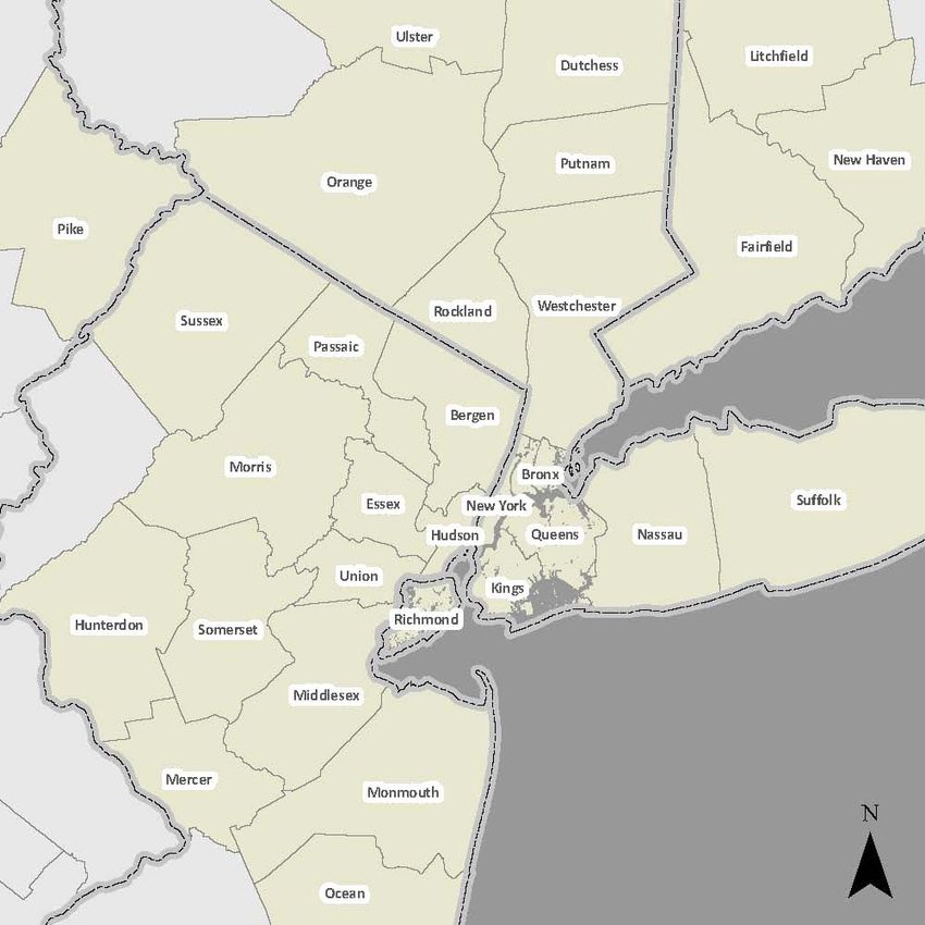
Exhibit 1 — NY Metro Region CSA
The Permanent Citizens Advisory Committee to the MTA (PCAC)
347 Madison Ave., NY, NY 10017 5Going the Distance — Transportation Mobility in the NY Metro Region October 2009
Transportation Agencies Serving the Region
The following are the primary transit agencies in the region. Further details of
these entities are described in Appendix A.
MTA
The MTA, is a public benefit corporation chartered by the NYS Legislature in
1965, 11 and serves as the umbrella organization for NYCT, MNR, LIRR, Long
Island Bus (LIB), and Bridges and Tunnels (B&T). This is the largest public
transportation provider in North America:
Table 1
MTA Totals at a Glance*
2008 operating budget $10.8 billion
Average weekday ridership 8,505,966
Rail and subway lines, and bus routes 422
Rail and subway cars 8,934
Buses 6,346
Track miles 2,057
Bus route miles 3,903
Rail and subway stations 734
Employees 69,117
* Budget as of February 2008; other statistical information
as of December 31, 2007.
Source: MTA
NJ TRANSIT
NJ TRANSIT operates most of the commuter rail and bus service in New Jersey,
but most of the service is focused in the NY Region as described above. All NJ
TRANSIT commuter rail lines connect to NYC either directly or via transfers at
Newark Penn Station or Secaucus Junction. NJ TRANSIT’s commuter rail lines
have the nation’s third highest ridership, after LIRR and MNR. NJ TRANSIT bus
lines, along with numerous private operators, deliver commuters through the
Lincoln Tunnel into the Port Authority Bus Terminal (PABT). 12
11
http://www.mta.info/mta/network.htm
12
http://www.njtransit.com/hp/hp_servlet.srv?hdnPageAction=HomePageTo
The Permanent Citizens Advisory Committee to the MTA (PCAC)
347 Madison Ave., NY, NY 10017 6Going the Distance — Transportation Mobility in the NY Metro Region October 2009
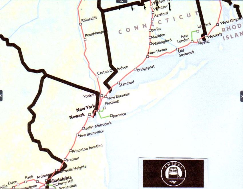
Amtrak
Amtrak, the nation’s intercity rail service, runs two long distance rail lines through
NYC — the Northeast Corridor Line and the Empire Line. Coming from New
Jersey, using the original 1910 Hudson River tunnels, the Northeast Corridor
Line stops at NY Penn Station, crosses through the East River Tunnels into
Queens (NYC), moves across the Hell Gate Bridge into the Bronx (NYC), and
continues towards New Rochelle and Connecticut. The Empire Line moves north
from NY Penn Station along the Hudson through Manhattan and the Bronx
enroute to Albany and Syracuse. Amtrak owns and operates NY Penn Station,
but shares its use with NJ TRANSIT and LIRR. 13
Exhibit 2 — Amtrak Route in NY Metro Region
Source: Amtrak
13
www.amtrak.com
The Permanent Citizens Advisory Committee to the MTA (PCAC)
347 Madison Ave., NY, NY 10017 7Going the Distance — Transportation Mobility in the NY Metro Region October 2009
Port Authority of NY and NJ (PANYNJ)
PANYNJ is responsible for maintaining the bridges (George Washington,
Verrazano, Goethals, Outerbridge Crossing and Bayonne) and car/truck tunnels
(Lincoln, Holland) between New York and New Jersey. It also operates the
PATH (Port Authority Trans-Hudson) rail service between Midtown and Lower
Manhattan in New York, and Newark, Harrison, Jersey City and Hoboken in New
Jersey. The PATH utilizes two former railroad tunnels under the Hudson River,
one going to the World Trade Center site, 14 one going to Midtown at 33rd and 6th
Avenue, a block from Penn Station. The AirTrain service to JFK and Newark
Liberty Airports is also under the PANYNJ. Lastly, the Port Authority is
responsible for the PABT in Midtown Manhattan, used by 7,000 buses and
200,000 commuters each weekday, and the George Washington Bridge Bus
Station (GWBBS) in Washington Heights, Manhattan, with 18,000 commuters
each weekday. 15
Bee-Line Bus
Westchester County’s Bee-Line Bus service is one of the most robust bus
networks in the Region. The system's 64 routes are mostly concentrated in the
more urban southern portion of the county. However, all but the county's
smallest, most rural communities have at least rush hour service. Bee-Line is a
public/private partnership whereby Westchester County owns the buses and
private companies operate the routes. Its annual ridership is 32.4 million. 16
Transport of Rockland
The Transport of Rockland (TOR) provides bus service within Rockland County,
New York, with stops at MNR West of Hudson stations in Rockland County and
service (Tappan ZEExpress) to the Tarrytown and White Plains MNR rail stations
in Westchester County. 17
Dutchess Loop
The Loop provides public transit service to Dutchess County through fixed routes
and demand services of Dial-A-Ride and Paratransit. LOOP runs a Commuter
Train Connection bus service in cooperation with MNR. Three stations, Beacon,
New Hamburg and Poughkeepsie are supported by this commuter bus service. 18
Putnam Transit
Putnam Transit, supported by Putnam County, serves the eastern portion of the
County through five routes that include stops at the MNR Harlem Line stations. 19
14
The Port Authority owns the World Trade Center site as well.
15
Port Authority website http://www.panynj.gov/CommutingTravel/bus/html/gwb.html
16
According to Larry Salley, Commissioner, Westchester County Department of Transportation.
See http://www.westchestergov.com/gettingaround_transit.htm
17
http://www.co.rockland.ny.us/PublicTrans/index.htm
18
http://www.dutchessny.gov/CountyGov/Departments/Planning/PLLoopbus.htm
19
http://www.putnamcountyny.com/PART/
The Permanent Citizens Advisory Committee to the MTA (PCAC)
347 Madison Ave., NY, NY 10017 8Going the Distance — Transportation Mobility in the NY Metro Region October 2009
Orange County
Orange County, NY is served by Coach USA/Shortline for both commuter service
to PABT and GWBBS, and travel within the County. NJ TRANSIT also offers
service from Warwick, New York through New Jersey into PABT. There is also
local service in Newburgh by the Newburgh Beacon Bus Service and in
Middletown by the Middletown Transit Corp. 20
Ulster County
The Ulster County Transportation Department operates the Ulster County Area
Transit (UCAT) service which provides bus transportation throughout Ulster
County with limited service to Orange County (Newburgh) and connecting
service to Dutchess County (Poughkeepsie). 21
Suffolk County Transit (SCT)
SCT operates 53 routes across Suffolk County with a fleet of 180 buses. 22
Hampton Jitney
Hampton Jitney, headquartered in Southampton, NY, Long Island, serves the
eastern end of Long Island with upscale bus service to Manhattan for commuters
and weekend visitors. 23
Ferries
A number of ferry services operate within the NY Metro area, often connecting
with rail and/or bus transportation (see Appendix A):
• NY Waterway
• New York Water Taxi
• Liberty Water Taxi
• SeaStreak
• Staten Island Ferry
• Bridgeport & Port Jefferson Steamboat Company
Regional Service Integration
Commuter Rail Connections to the Core
Manhattan initially became the core of the NY Metro Region largely because of
its strong access to water. With the Hudson River, and subsequently the Erie
Canal to the North, and the Atlantic Ocean to the West, New York’s harbor has
served as an important point in trade routes. However, just as this access to
water has helped the city’s transportation needs, it also creates complications for
20
http://www.ocny.com/transportation/bus.php
21
http://www.ulstercountyny.gov/ucat/
22
http://www.sct-bus.org/
23
http://www.hamptonjitney.com/cgi-bin/nav.cgi?page=home.html
The Permanent Citizens Advisory Committee to the MTA (PCAC)
347 Madison Ave., NY, NY 10017 9Going the Distance — Transportation Mobility in the NY Metro Region October 2009
ground modes. As such, the investments in connecting Manhattan to the
surrounding land through bridges and tunnels have been immense.
Presently, 10 tunnels connect regional rail travelers to Manhattan (see Exhibit 3A
below): Under the Hudson River there are the four PATH tunnels and the two
Amtrak tunnels to Penn Station, also used by NJ TRANSIT; under the East River
there are four Amtrak tunnels that are employed by both the LIRR for its normal
operations into NYC and NJ TRANSIT to lay up trains in the Sunnyside Yards in
Queens.
Exhibit 3A — Rail Access to the Core: Tunnels
The Permanent Citizens Advisory Committee to the MTA (PCAC)
347 Madison Ave., NY, NY 10017 10Going the Distance — Transportation Mobility in the NY Metro Region October 2009
In addition, there are three bridges which help connect Amtrak and commuter rail
to Manhattan (See Exhibit 3B below). The Park Avenue Railroad Bridge across
the Harlem River is used exclusively by MNR trains. The second connector
bridge, the Spuyten Duyvil Bridge, connects Manhattan to the Bronx above the
Spuyten Duyvil Creek, which sits in between the Hudson and Harlem Rivers.
This is an exclusive Amtrak crossing as part of its Empire Service to Albany and
other upstate destinations. The third bridge, Hell Gate, is also an Amtrak
crossing (Northeast Corridor line) between Randall’s Island, Manhattan, and
Astoria Queens.
Exhibit 3B — Rail Access to the Core: Bridges
The Permanent Citizens Advisory Committee to the MTA (PCAC)
347 Madison Ave., NY, NY 10017 11Going the Distance — Transportation Mobility in the NY Metro Region October 2009
At this point it is useful to point out the limited compatibility of equipment used by
the four railroads. NJ TRANSIT and Amtrak are the most closely aligned. They
take electrical power from catenaries (overhead wires). Amtrak owns the line
infrastructure from Manhattan to Washington DC, which comprises its Northeast
Corridor service. NJ TRANSIT utilizes the same tracks for its Northeast Corridor
service from Trenton.
The LIRR, however, operates its equipment using a “third” rail for electric power
(similar to the NYCT subways). In some areas of Long Island the tracks have not
been electrified and there the Rail Road uses diesel powered or dual mode
(diesel/electric) engines.
MNR uses third rail electric and dual mode engines on its Hudson and Harlem
Lines; but the New Haven Line uses a combination of third rail (for travel out of
GCT to Mount Vernon East) and catenary trackage from there on. 24 Amtrak also
operates on the same New Haven line tracks once it reaches New Rochelle, New
York after crossing the Hell Gate Bridge. Interestingly, it is only the NJ TRANSIT
electric locomotive power that is capable of running under the various catenary
systems over three separate railroads (NJ TRANSIT, Amtrak and MNR’s New
Haven line) using different power supplies.
Commuter Bus Access to the Core
The heaviest bus traffic in the region is through the Lincoln Tunnel due to the
location of the PABT (See Exhibit 4A). Located in the heart of NYC, the PABT is
the world's busiest bus terminal, the region's primary ground transportation
facility, and the largest bus terminal in the United States. The terminal is located
one block west of Times Square, occupying the blocks between Eighth and Ninth
Avenues, from 40th to 42nd Streets. In 2008, an estimated 58.3 million
passengers flowed through the PABT on more than 2.2 million bus movements.
On a typical weekday, nearly 200,000 passenger trips passed through the PABT
on 7,000 bus movements. 25
The Lincoln Tunnel is the world's first three-tube underwater vehicular tunnel
facility between Midtown Manhattan and central New Jersey. The tunnel's three
tubes provide important flexibility in traffic handling with the ability to change the
six lanes to four lanes in one direction or three lanes in each direction by
converting the center tube to a two-way operation. During the weekday morning
peak period (between 6:00 am and 10:00 am) the Port Authority operates a 2.5
mile exclusive bus lane (XBL). The XBL carries roughly 690–700 peak hour
24
Both the catenary and third rail overlap for a quarter of a mile between Mount Vernon East and
Pelham to facilitate this changeover.
25
See http://www.panynj.gov/CommutingTravel/bus/html/pa.html
The Permanent Citizens Advisory Committee to the MTA (PCAC)
347 Madison Ave., NY, NY 10017 12Going the Distance — Transportation Mobility in the NY Metro Region October 2009
buses or almost one bus every five seconds. Ninety-one percent of these buses
travel to the PABT. As a result, the XBL and the PABT are close to capacity. 26
The GWBBS located in the Washington Heights area of Upper Manhattan,
occupies a two-block site between 178th and 179th Streets, and Fort Washington
and Wadsworth Avenues. The bus station features a pedestrian walkway that
connects travelers with the 175th Street "A" line subway station. In 2008, an
estimated 5.2 million passengers flowed through the GWBBS on more than
324,000 bus movements; on a typical weekday, approximately 18,000 riders on
1,000 bus movements. This bus station is fed from the west by the George
Washington Bridge (GWB). This two-level bridge crosses the Hudson River
between upper Manhattan (West 178th Street) and Fort Lee, New Jersey and
forms part of Interstate Highway I-95.
Exhibit 4A — Commuter Bus Access to the Core: Hudson River
26
http://www.arctunnel.com/about/
The Permanent Citizens Advisory Committee to the MTA (PCAC)
347 Madison Ave., NY, NY 10017 13Going the Distance — Transportation Mobility in the NY Metro Region October 2009
The Tappan Zee Bridge (I287, part of the NY Thruway), from Rockland County,
NY across the Hudson into Westchester County, is used by the previously
mentioned Tappan ZEExpress bus service from Rockland County which serves
the MNR Tarrytown and White Plains train stations (See Exhibit 4A).
It should be noted that the other major connector from NJ to Manhattan is
PANYNJ’s Holland Tunnel, from Jersey City to Canal Street in NYC. However,
commercial vehicles are prohibited from entering NYC via the Holland Tunnel
and are encouraged to use the Lincoln Tunnel and George Washington Bridge
as alternatives. 27
Other bridges from NJ to NYC operated by the PANYNJ are the Outerbridge
Crossing, the Goethals Bridge and the Bayonne Bridge, all of which connect to
Staten Island (SI) (See Exhibit 4B below). NYCT uses the Goethals Bridge to
run express bus service from SI to Manhattan through the Lincoln Tunnel and
NYCT runs bus service (S89) from SI over the Bayonne Bridge to the 34th Street
HBLR station.
Exhibit 4B — Commuter Bus Access to the Core: Staten Island
27
See http://www.panynj.gov/CommutingTravel/tunnels/html/holland.html
The Permanent Citizens Advisory Committee to the MTA (PCAC)
347 Madison Ave., NY, NY 10017 14Going the Distance — Transportation Mobility in the NY Metro Region October 2009
Transit Access within NYC
NYCT Subway Bridges and Tunnels
Many subway tracks also cross into Manhattan from the outer boroughs. There
are 10 subway tunnels and two subway carrying bridges (Manhattan and
Williamsburg) that cross the East River between Manhattan and Brooklyn (See
Exhibit 5A). There are three tunnels and one bridge (Broadway Bridge) that
serve subway lines from Manhattan into the Bronx (Exhibit 5B). There are also
the North and South Channel bridges that carry the A and C subways in the
Rockaways (Exhibit 5C).
Exhibit 5A — Subway Bridges and Tunnels: East River
The Permanent Citizens Advisory Committee to the MTA (PCAC)
347 Madison Ave., NY, NY 10017 15Going the Distance — Transportation Mobility in the NY Metro Region October 2009
Exhibit 5B — Subway Tunnels and Bridges: Harlem River
Exhibit 5C — Subway Bridges: The Rockaways
The Permanent Citizens Advisory Committee to the MTA (PCAC)
347 Madison Ave., NY, NY 10017 16Going the Distance — Transportation Mobility in the NY Metro Region October 2009
NYCT Bus Bridges and Tunnels
Within NYC, buses traverse numerous bridges and one tunnel (Brooklyn Battery)
to connect the outer boroughs with Manhattan and each other.
Exhibit 6A — Bus Bridges and Tunnel: East River and Harlem River
Exhibit 6B — Bus Bridges: Brooklyn and Staten Island
The Permanent Citizens Advisory Committee to the MTA (PCAC)
347 Madison Ave., NY, NY 10017 17Going the Distance — Transportation Mobility in the NY Metro Region October 2009
Long Island Intra-island Mobility
While the LIRR permeates most areas of Long Island (10 Branches) the direction
of travel is mostly east-west. As noted previously, not all of the system is
electrified and the far eastern areas, known as “diesel territory”, are subject to
slower speeds and frequent breakdowns. 28 Supplemental mobility, particularly
for north-south travel, is provided by Long Island Bus (LIB) 29 in Nassau County
and SCT and HART in Suffolk County. These systems are thin in both
geographic coverage and level of service. There have been many calls for the
expansion of LIB and SCT systems and their merger into a regional bus system
under the aegis of the MTA. 30 As part of its MTA 2010–2014 Capital Program,
the MTA will perform a study of all the bus providers in its service area to assess
and recommend the best region-wide operating and funding scheme for these
services. 31
Rail Service Integration/Choke Points/Missing Links
Two issues central to improving rail integration in the region are relieving choke
points or bottlenecks along rail lines, and upgrading inter-suburban connectivity.
According to the Regional Plan Association (RPA), investments in relieving
choke points, also known as bottlenecks, are more effective for lowering total
travel times than focusing on European-style high speeds in unchoked areas. 32,33
According to the MTA’s recently released Twenty Year Capital Needs
Assessment 2010–2029, many areas in the Tri-state region are currently
experiencing choke points due to the tremendous ridership increases that have
occurred between 1990 and 2008: “During this time MTA ridership on all modes
increased 55%”. 34 These existing choke points will become even more stressed
28
See PCAC’s 2008 Annual Performance Review of the MTA for a discussion of the LIRR diesel
fleet: http://www.pcac.org/reports/mtaassessments/
29
LIB is financed by Nassau County which owns the fleet and facilities. However, NYCT’s
Department of Buses operates the system.
30
See the Ravitch Commission’s recommendations on creating a regional bus system:
http://www.ny.gov/governor/press/pdf/press_1204082.pdf
31
http://www.mta.info/mta/capitalprogram.html
32
Hagler, Yoav. “Breaking up Bottlenecks from Tracks to Ticketing.” Spotlight Vol. 8, Number 10.
Regional Plan Association. http://www.rpa.org/2009/05/spotlight-vol-8-no-10-breaking-up-
bottlenecks-from-tracks-to-ticketing.html. May 27, 2009.
33
Hagler gives this example: The Baltimore and Potomac Tunnels, opened in 1873, still today
serve Amtrak and commuter rail trains. The tunnels’ grades are too steep, and their turns are too
sharp. As such, the top speed in the tunnels is 30 mph. Though it may be counter intuitive,
upgrading just a two-mile stretch of track in a choked tunnel like this such that trains could go 90
mph instead of 30 mph would save nearly three minutes in travel time. Making the same 60 mph
improvement, from 90 mph to 150 mph, would actually require upgrading 10 miles of track to
reach the same three minute time savings. Going from 150 mph to 210 mph would require an
entire 27 miles of track to achieve the same three minute reduction. As such, Amtrak’s plan to
upgrade most of the southern half of the Northeast Corridor to allow speeds of 150 mph in
unchoked areas might not be as effective an investment as upgrading or providing alternatives for
older, slower tunnels such as those under Baltimore, or the Amtrak Tunnels under the Hudson.
34
p. 78
The Permanent Citizens Advisory Committee to the MTA (PCAC)
347 Madison Ave., NY, NY 10017 18You can also read