Greater Kakwa area, Alberta, Canada - CSPG
←
→
Page content transcription
If your browser does not render page correctly, please read the page content below
Greater Kakwa area, Alberta, Canada
• Modern Resources for supporting this study;
  Darren Tisdale, Eric Keyser and Francois Legault
  for many helpful discussions.
• Tom Moslow, Dave Smith, Rob Sadownyk & the
  rest of the Canadian Hunter crowd.
• Greg Feltham, Pete Sutherland the Ikkuma crew
• Richard Harris and the Jupiter crew.
• Raphael Wust & Cory Twemlow at Trican

                                     2
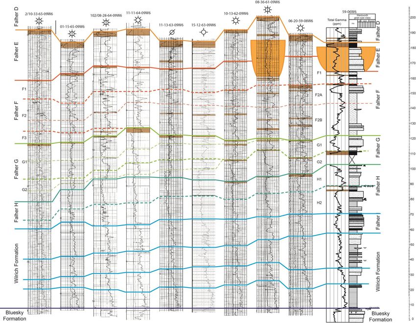
• Stratigraphic frameworks: within the Spirit
  River Formation as well as between Spirit
  River members & adjacent units (the
  importance of standardizing terminology).
• Depositional models for the Falher G-H
  interval.
• Petrographic observations in the G-H
  interval & influences on reservoir aspects.
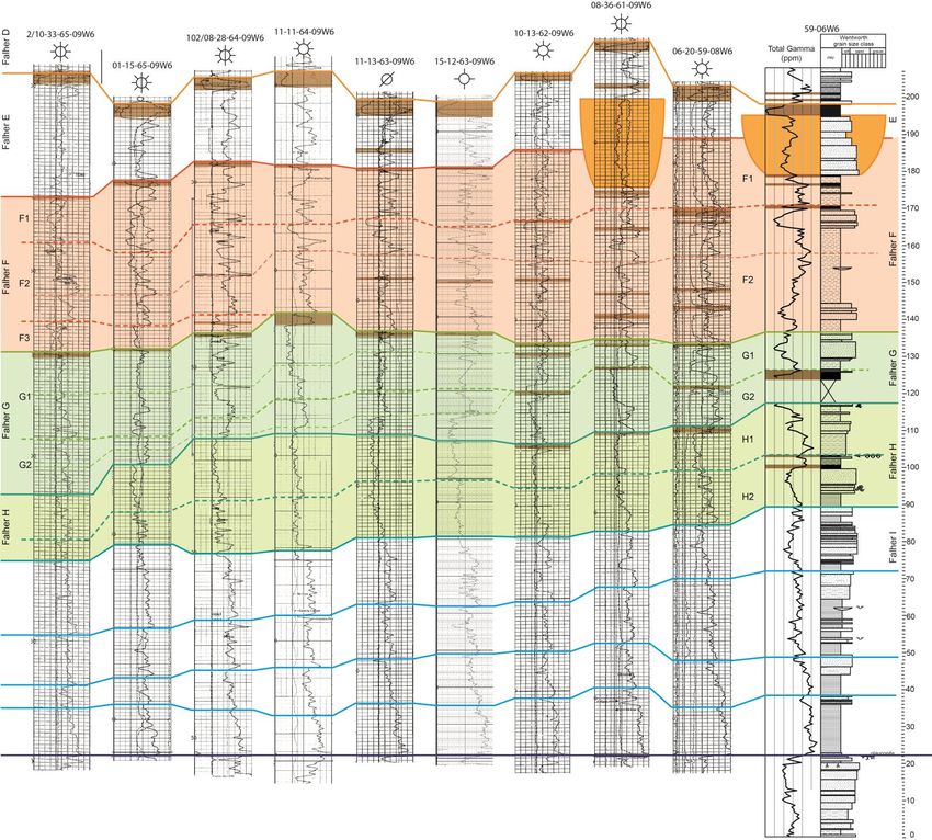
• The lowest / oldest formally named Falher submember is
  the Falher F; however numerous well-sorted sandstone
  shingles occur beneath the Falher F conglomerate
  interval.

• These horizons have distinct reservoir and exploitation
  attributes that differ from one region to another and from
  one horizon to the next.
Falher G/H
                          Falher D
ravinement                           Falher E (coastal plain)
surface                                      Falher F1
                                                     Falher F2/F3
Wilrich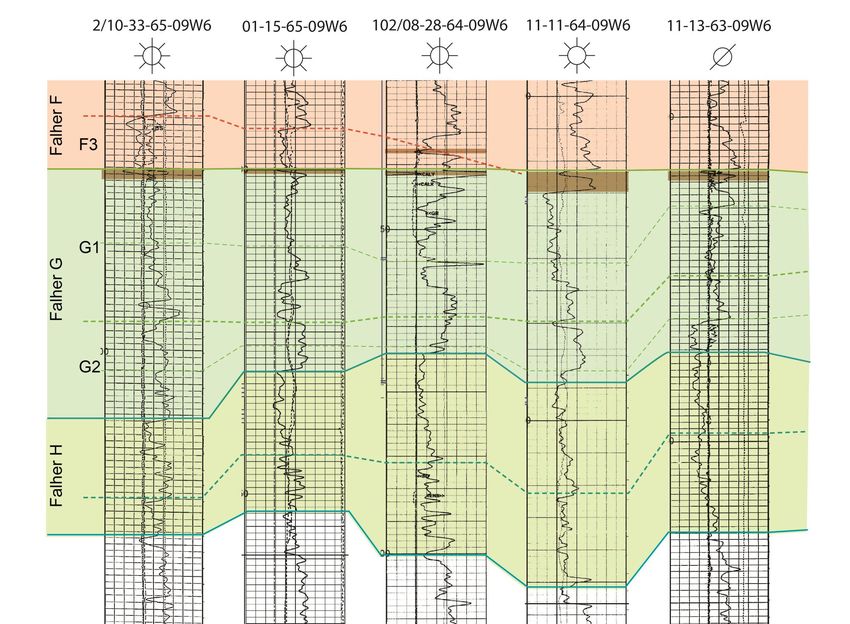
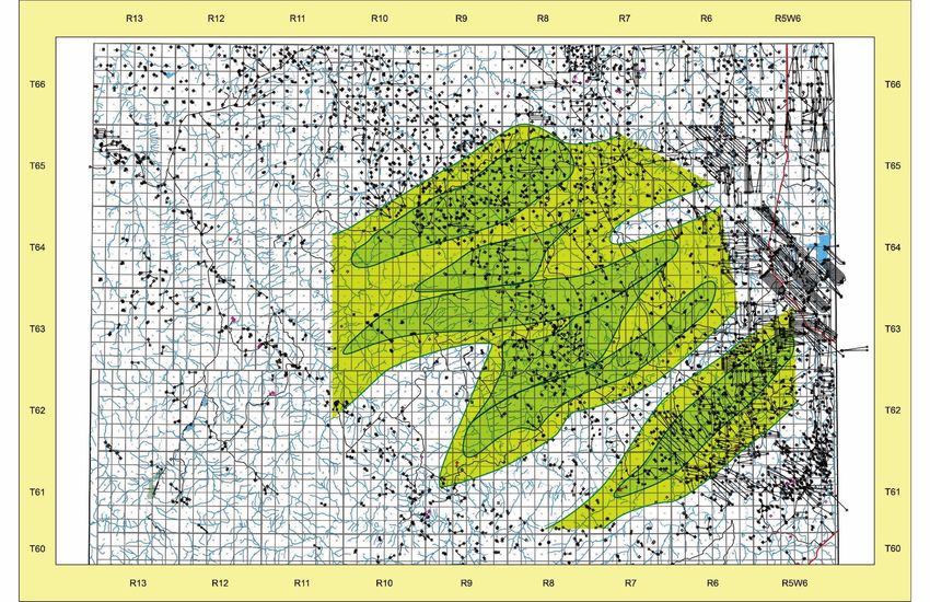
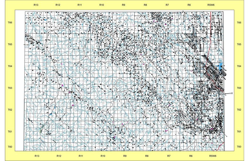
• Study area extends
Wapiti              from the Front Ranges
                    outcrop belt (between
                    Grande Cache, Alberta
Redrock             & Holtslander Ridge,
                    BC) and the south
                    Wapiti area, particularly
                    the Redrock and Route
          Route     fields).
                  • All available Falher and
                    Wilrich core between
                    townships 45 and 65
                    3W6 have been
                    analyzed.

                            6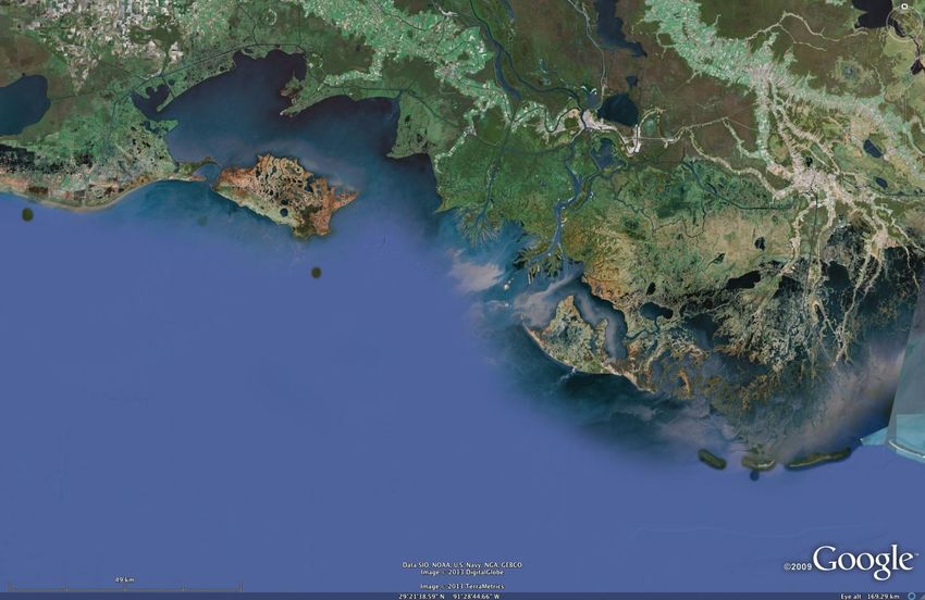
Spirit River Formation

                             Greater Kakwa
                               Study area

Bluesky
                                                   Warters et al., 1999

• Places the Glauconite with the middle Spirit River (Falher F-G-
  H interval.
• Erroneous correlation and should be discontinued.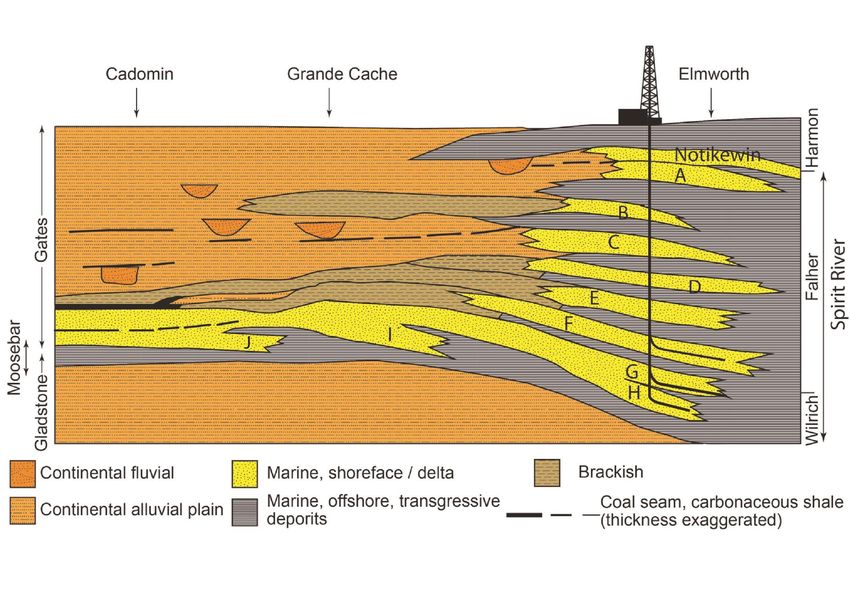
Falher A-F      Glauconite

• Glauconite to the south; Wilrich-
  Falher to North.
• But…… this correlation still infers that
  the Glauconite is interbedded with the
  Wilrich.
A
                      B
                     C
                     D             H
                       E
                        F
                            G

• (unpublished framework by Smith (1983) in Jackson, 1984; Smith et
  al, 1984; Rahmani, 1984).
• Subsequent authors (eg. MacDonald et al., 1988; Zonneveld and Moslow.
  2004; Newitt, 2017) have continued the trend.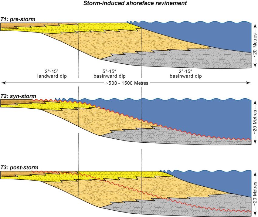
Newitt, 2017

• Sandstone shingles identified as Falher A-P
  interfingering with Wilrich shale.
• Drills at slower rates but       • Drills much more rapidly.
  responds well to stimulation.    • Excellent producer, wells
• Prolific producer; hosts some      are not as prolific as the
  of the best wells in the area.     Falher G interval.
• Example: 01-11-64-09W6           • Example 01-08-64-08W6
• Maintaining two discrete (but close) reservoirs horizons
  produces more opportunities. At current well spacing there is
  no direct pressure response in adjacent wells during fracs.
• Regional trend of drier wells to southwest; richer wells to
  northeast.
• Consistently ~20-30% overpressured throughout area.
North                               South

Falher E

               Southern limit of
              Falher F production
Falher F

Falher G

Falher H

Wilrich Fm.

Bluesky Fm.
North South Falher E Falher F Falher G Falher H Wilrich Fm. Bluesky Fm.
North South
• Bluesky top denotes a
  coplanar TSE / maximum
  flooding surface.
• Several sub-Falher H
  cycles.
• Each the Falher H, G and
  F consist of several
  parasequences.
• Major units bound by
  coal beds.
• Overall progradational
  succession with some
  subsidence-induced
  ‘backsteps’
03-33

                            13-27

Falher F legacy field    12-22

                                                         06-30
                                 15-12                   01-07

 Falher G and H sand shingles                    08-07
                                         08-01
                                                             16-21
• Influence on depositional setting for sandstone shingle geometry, vertical architecture, and horizontal continuity • Lateral changes in architecture of individual shingles and shingle-sets. • Lateral variability of within-parasequence mineralogy and grainsize.
• Narrow inland seaway.
• Montane highlands to
  west.
• Lowlands to south &
  east.
• Seaway debouches into
  northern sea (Palaeo-
  Beaufort Sea).
• Albian (~ 103 mya)
• Southern transgressive
  limit Calgary or south.

        Adapted from Blakey, 2016
        https://deeptimemaps.com
Falher F
• Cored through the
Falher G
F-G-H succession
on the eastern side
of the study area.
Falher HFALHER
G 06-30-63-05W6 FALHER H INTERVAL
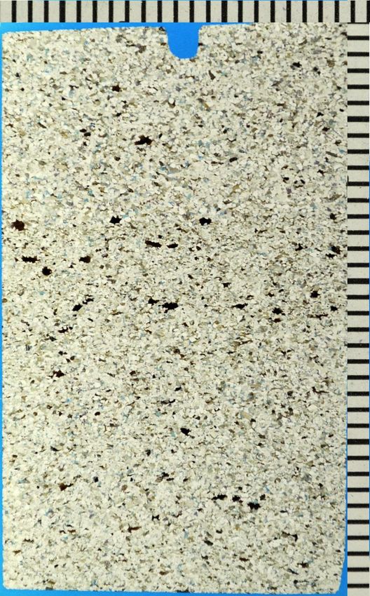
• Low trace fossil diversity.
• Common organics on bedding
planes.
• Numerous internal scour surfaces.
• Thick ‘clean’ sandstone interval.
• Siderite granules common in some
beds.
FALHER H
1 cm• Low overall trace fossil diversity
FALHER
(higher in heterolithic intervals).
F
• Common sand-sized siderite
FALHER
clasts on bedding planes.
G1
• Variable sandstone/shale ratio
(changes from base to top).
06-30-63-05W6
FALHER G
INTERVAL
FALHER
G2
FALHER
HFALHER G
• Prodeltaic succession, heterolithic,
common convolute bedding, low
trace fossil abundance and diversity.
24FALHER G
• Wave reworked deltaic succession,
common intraclasts, low angle to
trough cross-stratified
25FALHER G
• Upper shoreface intertidal sand bar on a
subsiding delta front setting, common
normal grading and draped ripples on
tidally influenced point bar deposits.
26wave-modified deltas
barrier
island
coal swamp
poorly drained
alluvial lowlands
meandering offshore
River systems sand shoals• Stressed environmental conditions: likely salinity stress, combined with seasonal temperature stress & periodic oxygen stress.
• Low biodiversity in all sandstone successions
  observed in core.
• Low biodiversity in all silty shale / muddy
  sandstone successions observed in core
• Strong local shingle persistence / much more
  variable on a regional scale.
• Concentration of thick deltaic sand lobes in the
  Route-Red Rock fairway (abundant multilevel
  locations).
Tiger Shoal

             Trinity Shoal

• Abandoned delta lobes;       Cailloux Bay
  reworked into barrier                       Isles Dernieres
  islands (Isles Dernieres),
  which eventually subside                    Ship Shoal
  into subtidal bars.
Caillou Bay
Caillou Bay
Timbalier Island
Ship Shoal
Caillou Bay Isles Dernieres
Isles Dernieres W
Ship Shoal
Ship Shoal
Isles Dernieres E
Cat Island Pass
Ship Shoal
Timbalier Island
Adapted from Penland et al., 19860m-
shoal crest
2m-
shoal front
4m- shoal base
lagoon
6m- distributary
delta front
8m-
prodelta Sharp-based stacked sandstone shingles, similar
in architecture to some
10m-
• Adapted from Penland et al., 1986• Narrow northern (subarctic) opening • Numerous rivers feeding basin, likely persistent basinwide salinity stress & seasonal stratification. • Short-run rivers on western margin: thus deltas and shoreface sand bodies are texturally & mineralogically immature.
• Falher G / upper H
  interval.
• Wave-reworked
  deltaically influenced
  shoreface
• Abundant intra-shingle
  erosional surfaces,
  commonly with
  phytodetrital lags
• Common in every core (& common in outcrop; Moslow, 1995).
• Intra-unit erosional surfaces with abundant phytodetrital lags.
• Proximal to deltas chert granule / pebble and siderite granule
  lags are common.
• Influence of mineralogy (constituent grains
  and cements) on the ‘drillability’ of
  individual sandstone shingles.
• In the eastern side of the study area the
  Falher F-G-H intervals shows no real
  mineralogical differentation.
• In the Redrock/Route area, the Falher G
  and H have markedly different grain and
  cement mineralogies.
• FALHER H; 2814.9m

      Cht                     Cht

                                Alb
       Alb              Alb

       Cht                     Cht

        Cht                         Cht

                  Chl
Cht
             OM
                                               Cht
Sid    Alb
                                          Suture
• 2793m
Albite
Dolomite
Quartz
K-feldspar
Albite
Quartz• FALHER G2; 2778.1M
Alb
Qtz Cht
Fe-Cal
xpl
Alb
Fe-Cal Cht
Alb
pplFe-Cal
Qtz og
Fe-Dol
Cht Qtz • Falher G in 08-01 is
dominated by chert
and quartz.
• Abundant & diverse
Fe-Cal carbonate cements.
Qtz og
Fe-Dol
Cht
Cht Qtz• Igneous, metamorphic & Sed
sedimentary rock
fragments.
Met
Rad
Qtz overgrowth-Falher F (fluvial / crevasse splay)
quartz
-Falher G1 (dist. channel)
-Falher G2 (delta front / shoreface) quartz arenite
-Falher H1 (delta front / shoreface)
-Falher H2 (delta front / shoreface) subarkose sublitharenite
-Falher H3 (proximal prodelta)
• Detrital mineralogy
• Alteration products &
cements not counted
No clear mineralogical evolution
Pattern consistent with source mixing
feldspar Rock fragments (incl. chert)-Falher F (fluvial / crevasse splay) quartz
-Falher G1 (dist. channel)
-Falher G2 (delta front / shoreface) quartz arenite
-Falher H1 (delta front / shoreface)
-Falher H2 (delta front / shoreface) subarkose sublitharenite
-Falher H3 (proximal prodelta)
• Detrital mineralogy
• Alteration products included
• Closer to original mineralogy
• Tighter groupings but only
accurate if carbonate
assumption is correct
Tighter clustering but pattern
still indicates source mixing
Feldspar Rock fragments (incl. chert)
(Fld + carb/2)-Falher G1-i (upper shoreface / foreshore)
-Falher G1-ii (upper shoreface / foreshore)
quartz
-Falher G1-iii (upper shoreface / foreshore) quartz arenite
-Falher G2 (upper shoreface / foreshore)
-Falher G (baymouth bar) subarkose sublitharenite
-Falher H (upper shoreface)
• Clear evolution from lithic
arkose in lower intervals to
litharenite in upper
• Much higher chert content /
carbonate content up section
mineralogical evolution from
lithic arkose to litharenite
feldspar Rock fragments (incl. chert)• Samples characterized by several phases of silica
cementation as well as several types of carbonate
cement including calcite, Fe-calcite, dolomite and Fe-
dolomite.
Falher G in 08-01-62-08W6, 3389.80; Degraded dolomite, ferroan
dolomite rim in a secondary chert cement matrix.Alb Fe-Dol
Alb
2778.1m, Falher G2
2759.5m, Falher F2
Alb
06-30-63-05W6,
06-30-63-05W6,
Alb
Qtz
• Clay rims common in most
Alb
units.
2793.0m, Falher H1
• Primarily illite; less
06-30-63-05W6,
commonly kaolinite.
Fe-Cal
ChtFalher G-H Paragenetic Succession Major Diagenetic Total Events Early Late Porosity Illite/Kaolinite Chlorite Si cement phases Fe-Calcite Compaction / stylolitization Dolomite Fe-Dolomite Feldspar dissolution / seritization Final Quartz cement
08-01 Falher G                        06-30 Falher G
•   Abundant chert granule layers.    • Lithic arkose
•   Sandstone consists primarily of   • Moderate to abundant feldspar
    a lithic arenite.
•   Rare feldspar / abundant
                                      • Sand-dominated; no chert
    carbonate                           granules / pebbles.
•   Chert / chalcedony cement         • Common patchy clay rims on
    common                              sand grains
•   Rare clay rims on sand grains.
08-01 Falher H                        06-30 Falher H
• Sand-dominated, granules-           • Feldspathic litharenite to lithic
  pebbles absent                        arkose
• Sandstone consists primarily of     • (primarily albite; some K-spar)
  a lithic arkose                     • Sand-dominated, rare chert
• Rare carbonate, abundant              granule lags.
  feldspar (albite).                  • Common patchy clay rims on
• Common patchy clay rims on            sand grains
  sand grains
• The Spirit River Fm. in the study area produces from two discrete, parallel horizons; herein denoted the Falher G and Falher H. • Deposition of both units reflects coalescing river- and wave-dominated deltas, sourced by numerous short-run river systems, into a constrained inland seaway. • In the current exploration/exploitation fairway at Redrock and Route, the Falher G and H intervals exhibit contrasting reservoir attributes reflecting differences in grain and cement mineralogy.
• Reservoir rocks in the Falher G have a greater
  proportion of chert, abundant and diverse carbonate
  replacement, and more pervasive silica cements (quartz,
  chert & chalcedony). This results in a reservoir with
  lower ROP but excellent response to stimulation.
• Reservoir rocks in the Falher H have a greater
  proportion of feldspar, less common carbonate, less
  pervasive silica cements and more common clay rims on
  sand grains. This results in a reservoir with higher ROP
  and good response to stimulation.
Modern Kakwa 16-18-64-8W6, Nov., 2017
You can also read