Greater Norwich Growth Board

Greater Norwich Infrastructure Plan

May 2020
←
→
Page content transcription
If your browser does not render page correctly, please read the page content below

Greater Norwich Growth Board Greater Norwich Infrastructure Plan May 2020
Contents

                                                                              Page
 1.   Introduction                                                             2

 2.   Funding and Delivery                                                     5
      This section outlines funding and delivery arrangements
      including the City Deal and the New Anglia LEP Growth Deal

 3.   Key Infrastructure                                                       9
      This section outlines the infrastructure required to support
      growth

 4.   Major Growth Locations                                                   19
      This section identifies where growth is expected to happen in the
      next few years

      Appendix A Infrastructure Framework                                      32
      This section lists all the currently planned strategic infrastructure
      projects.

      Appendix B Neighbourhood Plan                                            48
      This section lists all projects identified within agreed
      neighbourhood plans.

                                         1
1. Introduction
1.1 The Greater Norwich area, covering the districts of Broadland, Norwich and
South Norfolk, is a key engine of growth for the United Kingdom. The Joint
Core Strategy for the area (JCS) aims to deliver 27,000 jobs and 37,000
homes between 2008 and 20261. Greater Norwich is one of the fastest
growing areas in the country and has established itself as a leader in health
and life sciences, digital creative and advanced manufacturing and
engineering. The Greater Norwich City Deal, signed with government in
December 2013, aims to bring an additional 13,000 jobs to the area, as well
as 6,000 jobs in construction, and accelerate the delivery of 3,000 homes
within the Growth Triangle. Through the City Deal the Greater Norwich
Growth Board (GNGB) partners’ ambition is to enable the existing world class
knowledge to develop and grow into world class jobs and a thriving economy.
1.2 The Greater Norwich Local Plan (GNLP) is currently being developed. It will
identify and provide for additional housing and jobs growth required to 2038.
When it is adopted, which is scheduled for 2022, it will supersede the JCS
and other local plan documents.
1.3 This document, the Greater Norwich Infrastructure Plan (GNIP), helps co-
ordinate and manage the delivery of strategic infrastructure to support
growth, a high quality of life and an enhanced natural environment. It informs
prioritisation of investment and delivery. It is not an exhaustive list. It is a
living document, updated annually to reflect the latest information.
1.4 The GNIP supports the delivery of the JCS, other Local Plan documents for
the area, local economic strategies, the Greater Norwich City Deal, the
Norfolk and Suffolk Economic Strategy and Local Industrial Strategy (both
produced by the New Anglia Local Economic Partnership). It draws on work
to identify and secure the key infrastructure required to support growth as set
out in the Joint Core Strategy Infrastructure Framework (included in JCS
Appendix 7 and 7a). The updated Infrastructure Framework is included as
Appendix A.
1.5 While mainstream funding provides the primary support for new
infrastructure, contributions from new development, such as Section 106
agreements and Community Infrastructure Levy are also important. Section 2
of this report provides an overview of funding and delivery mechanisms.
1.6 Section 3 outlines the range of infrastructure required to support growth,
including that delivered and funded by other means – e.g. Asset Management
Plans, or infrastructure directly delivered or funded by development.
1.7 The GNIP concentrates on the key infrastructure requirements that support
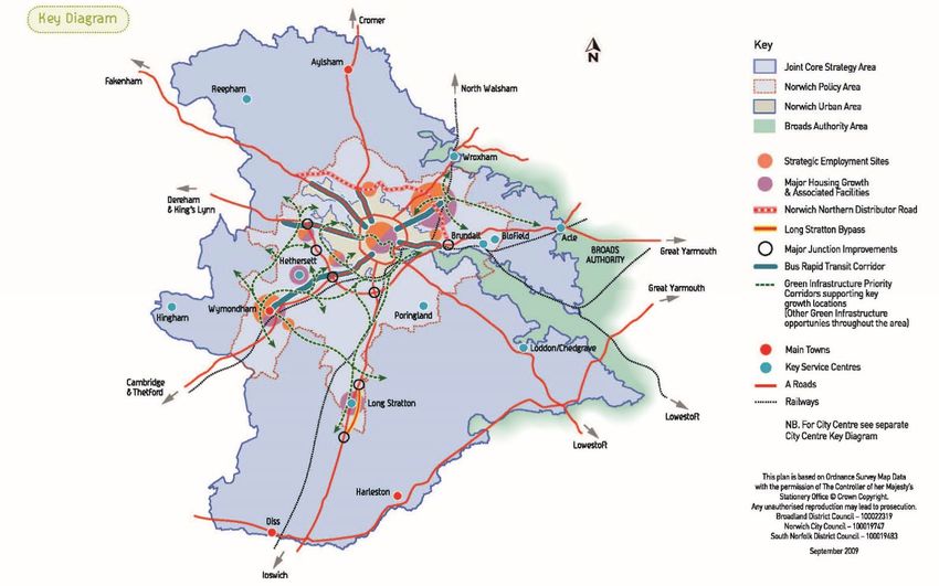
the major growth locations (see Figure 1 – Joint Core Strategy Key Diagram)
or the overall scale of growth. Individual developments tend to require smaller
scale infrastructure that is not detailed here. Section 4 provides an overview
of the progress expected in the next few years on significant sites.
1.8 Many elements of key infrastructure can be implemented incrementally to
reflect emerging patterns of growth. This includes:
1
Report on progress-Annual Monitoring Report http://www.greaternorwichgrowth.org.uk/planning/monitoring/
2
•   enhancements to public transport corridors to deliver the key
           components that contribute towards the delivery of a Bus Rapid Transit
           network,
       •   elements of the green infrastructure network
        • extensions to cycle routes. enhancements to public
       transport corridors to deliver the key components that contribute towards the
       delivery of a Bus Rapid Transit network, elements of the green infrastructure
       network and extensions to cycle routes.
1.9    The GNIP provides greater detail of those schemes being delivered in the
       short term. It does not seek to review or prioritise agreed infrastructure
       but is a means of refreshing and managing the strategic programme,
       keeping it up to date and fit forpurpose.
1.10   However, as time moves on and projects evolve, some differences with
       previous work may be noted. This is because:
       •   Project titles can change to better reflect the details of the proposals.
       •   A project can support more than one topic, for example a cycle route can
           be both green infrastructure and transport infrastructure.
       •   The expected timing of infrastructure delivery can change, for example to
           reflect updated assumptions on the timing of the development that it is
           intended to support, or because funding has become available.
       •   Significant changes in timing can alter the nature of any proposed
           infrastructure, and the capacity of existing infrastructure to support growth
           can have changed in the interim.
       •   National policy and events such as Brexit and the Covid-19 outbreak are
           also expected to affect programme delivery and funding streams.

                                         3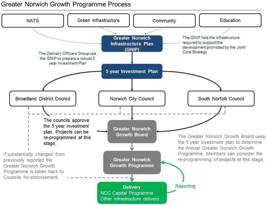
Figure 1: Joint Core Strategy key diagram

                                            4

                                            4
2.     Funding sources and delivery planning
    2.1    In December 2013, Broadland, Norwich City, Norfolk County, South Norfolk
           councils and the New Anglia LEP signed a City Deal with central
           government. A core theme of this deal supports infrastructure delivery to
           accelerate planned growth which is now collaboratively managed by the
           Greater Norwich Growth Board (GNGB).
    2.2    The City Deal identified a £440m infrastructure investment programme
           developed from the JCS Infrastructure Framework. The GNGB have put in
           place pooled funding and governance arrangements to manage timely
           delivery. To help fund the programme a forecasted £73m2 of Community
           Infrastructure Levy has been identified from the housing trajectory
           (excluding the proportion retained for local communities).
    2.3    Estimates for the total forecast amount of CIL collected over the plan
           period have reduced over previous years, in part due to the increase in CIL
           exemption categories but also due to a greater understanding of the
           complex nature of CIL. The GNGB will undertake a review of CIL alongside
           the development of the Greater Norwich Local Plan. This review will
           consider the updated CIL charging policy together with land values and
           levy rates, and as a result will affect the forecasting of future income. It is
           expected that the funding gap to support the infrastructure programme is
           likely to close as other funding streams are secured.
    2.4    The GNIP Infrastructure Framework (Appendix A) reflects the longer term
           and tends to identify the earliest date on which a piece of infrastructure can
           be delivered taking account of broad indications and reasonable
           assumptions of funding availability. The GNGB use the GNIP’s longer term
           context to inform and develop a shorter term 5-year Infrastructure
           Investment Plan and Annual Growth Programme (which can be found on
           the GNGB website). The Greater Norwich authorities work collaboratively
           to identify projects for delivery and the funding to support them. This
           funding includes their pooled Community Infrastructure Levy, Local Growth
           Fund, mainstream funding, the lobbying and identification of other funding
           streams (subject to applications and agreement e.g. Transforming Cities)
           and the use of borrowing. The GNGB manages the risks of delivery and
           provides a robust means of agreeing ongoing priorities.
    2.5    Local communities continue to retain 15% of Community Infrastructure
           Levy contributions to deliver schemes within their area (25% where there is
           a Neighbourhood Plan in place).

2
 The complexity of CIL forecasting leads to a very high margin of error in any projections, either up or down.
This forecast has been calculated prior to knowing the effects of the Covid-19 outbreak on CIL income.
                                                      5
Figure 2: Greater Norwich Growth Programme process

Note- NATS will soon be replaced by the Transport for Norwich Strategy

 Progress on delivering key infrastructure
 2.6        The Northern Distributor Road, officially named the A1270 ‘Broadland
            Northway’ is now fully open from the A1067 Fakenham Road to the A47 at
            Postwick.
 2.7        A major improvement at Thickthorn junction to address existing and future
            congestion problems has been included in the Highways England A47
            corridor improvement programme. The scheme is estimated to cost £25-
            50m with a construction period 2021-23.
 2.8        Delivery of the Transport for Norwich (TfN) programme is a New Anglia
            Strategic Economic Plan priority and remains a priority in the new Norfolk
            and Suffolk Economic Strategy. New Anglia LEP’s Growth Deal One (July
            2014), and the more recent Growth Deal Two (February 2015), confirmed
            Local Growth Funding (LGF) of £13m for scheme delivery from 2015- 2020.
            Final sign-off of the funding will be made by the New Anglia LEP Board.
            New Anglia’s Transport Body has been set up across Norfolk and Suffolk to
            provide advice to the LEP Board and manage central government funding
            devolved to the LEP for transport schemes.
 2.9        The TfN strategy includes funding of:

               •    £13m LGF

                                                        6
• £1.4M CIL
• £0.4M S106
• £15.8M from the Department for Transport’s City Cycle Ambition
Grant (CCAG)
This enables the delivery of transport infrastructure schemes within the TfN
area for the period 2015-2020.
2.10 To date, this funding from the LGF and CCAG has delivered public realm
improvements:
• pedestrian and cycle benefits in the city centre at Westlegate,
• enhanced roundabout at Dereham Road / Guardian Road,
• a significant traffic management and public realm improvement
scheme in Prince of Wales Road and Rose Lane which provides
quicker and more direct journeys whether on foot, by bike, in a bus or
car,
• improvements to key sections of the Blue, Green and Yellow
pedalways, including Newmarket Road, Earlham Road and through
Eaton village,
• improved public transport interchange at the UEA and a new
interchange at Cringleford, which enables travel by bus to the Norfolk
and Norwich University Hospital and the Norwich Research Park
without having to travel into the city centre,
• a ‘flagship’ off-carriageway cycleway linking Wymondham to
Hethersett.
2.11 In addition, works to be completed include:
• Measures to relieve congestion and improve journeys times for all
vehicles on the outer ring road at Colman Road.
2.12 The County Council was successful in being shortlisted as being one of 12
UK cities that is eligible to apply for a share of £1.2bn from the
Transforming Cities Fund (TCF). The application was based around the
vision of investing in clean transport, creating a healthy environment,
increasing social mobility and boosting productivity through enhanced
access to employment and learning. The County Council was successful in
securing £6.1m from Tranche 1 of the TCF, which is being used to fund the
delivery of 6 schemes in the period 2019/20:
• Pedestrian, cycle and public realm enhancements on Prince of Wales
Road, Bank Plain, London Street and Agricultural Hall Plain,
• Further cycle improvement works at Hethersett to complete the off-
carriageway cycle route between Wymondham and Hethersett,
• Cycle improvement works on the outer ring road at St Williams Way
on the Green pedalway,
• Improvements to Norwich Bus Station, including larger and
refurbished toilets, improved lighting and seating and enhanced travel
7information,
• Implementation of a cycle share (hire) scheme across Norwich
providing up to 600 manual and electric assist bikes,
• Construction of two new signalized crossings in the west of the city at
the Dereham Road / Bowthorpe Road junction, as well as the
Heigham Street / Mile Cross Road junction.
2.13 An application for Tranche 2 TCF funding was submitted in November 2019
for schemes to be delivered in the period up to the end 2022/23. No
decision on funding was made in the March 2020 government budget
announcement but a £117m pot has been set aside for Norwich,
Portsmouth and Stoke to competitively bid into. The exact requirements of
this are being discussed with the DfT but is likely to take until early-Summer
2020 for a further decision on funding to be made.
83. Key Infrastructure
3.1 There are a range of thematic-based mechanisms for the delivery of
infrastructure, including plans and strategies with their own objectives,
priorities and implementation plans. (A number of these are referred to in this
chapter). The GNIP is influenced by these plans and processes and supports
them to meet needs arising from emerging growth pressures.
3.2 The GNIP’s main themes are green infrastructure, transport, schools and
community facilities (which includes libraries, sports, recreation and
Neighbourhood Plan priorities). Other infrastructure themes are included
because they are required to support growth, but they are funded and
delivered by other means so the project delivery details do not feature in the
Infrastructure Framework within Appendix A.
Green Infrastructure
3.3 A Green Infrastructure Delivery Plan was produced in 2009 focusing on the
two main geographical areas identified for significant development: South
West and North East Norwich. It identifies a number of projects that contribute
to the protection and enhancement of the strategic green infrastructure
network and helps to inform delivery of new Green Infrastructure. Four major
green infrastructure initiatives are proposed to address the modelled impact on
sensitive environments that will result from housing growth to the North East
and South West of Norwich
• the Green Loop (linking Marriott’s Way, Bure Valley Path and the
proposed Broadland Way including linkages through the city such as the
Norwich Riverside Walk) (in development))
• Burlingham Country Park (in development).
• the Yare Valley Parkway: a linear park linking Bawburgh in the west
through to Whitlingham in the South East (in development).
• The North West Woodlands Country Park (funded and in delivery phase).
3.4 The projects in the GNIP are informed by the need to mitigate the potential
impacts on Natura 2000 sites under the Habitat Regulations, an
understanding of the timing of development served by the identified green
infrastructure corridors, and the emerging requirement to deliver biodiversity
net gain. It is also a key concern that enough high-quality green space is
available for the outdoor recreation needs of the growing population. These
can all be effectively delivered through multi-purpose green spaces and
corridors.
3.5 Strategic priorities:
• Projects that support delivery of Biodiversity Net Gain
• Projects which support the delivery of or connectivity to the Green Loop
• Projects which support the access on or connectivity to the Wensum
Riverside Walk, from Hellesdon to Whitlingham
• Projects which support the access on or connectivity to the Red
pedalway (which includes Marriotts Way)
9• Projects which support enhancement, access and connectivity to and
between green spaces around the major growth locations, Main Towns
and Key Service Centres
• Projects which support the development of the Yare Valley Parkway and
therefore help manage development pressure in the project area.
• Projects which provide viable alternative locations for recreational
use, reducing the impacts made on the internationally designated
sites arising from growth.
Transport
3.6 Provision is guided by the Norwich Area Transportation Strategy
(NATS) and its implementation plan, which was developed alongside
the Joint Core Strategy. NATS will be replaced by the Transport for
Norwich strategy (TfN) which is currently being reviewed alongside the
Greater Norwich Local Plan. An initial public consultation on a new TfN
strategy was undertaken in 2018, resulting in the following guiding
principles and delivery themes which have been approved by the
County Council:
Guiding Principles
• Strengthening Norwich as the regional capital.
• Access for all.
• Keeping people on the move.
Delivery Themes
• Balancing the needs of the city and its users
o Identify priority areas for different users to inform network
improvements.
o Take account of the competing travel needs of residents,
businesses and others.
• Collaborating to provide cost-effective and efficient transport
o Build strong partnerships with transport service providers.
o Develop opportunities for private sector investment.
o Share responsibility for positive change.
• Embracing new technology
o Encourage and trial new means of travel.
o Inform people’s travel choices.
o Optimise and evolve our existing network.
3.7 A Strategic Outline Business Case (SOBC) was submitted to the
government in November 2019 to obtain funding from the Transforming
Cities Fund (TCF). Scheme objectives consistent with the
requirements of the TCF and the emerging TfN strategy will address
the need to:
• Improve people’s productivity and social mobility by unlocking
10access to employment and education opportunities across the
Greater Norwich Region (GNR),
• Increase the efficiency of travel and transport in the GNR and
improve the impact transport has on carbon emissions, air quality
and public health,
• Use emerging technology to prepare GNR for a future of shared
and clean mobility.
3.8 The delivery of transport schemes in 2019/20 funded through Tranche
1 of the TCF is outlined in paragraph 2.12 of this report. Looking
further ahead, the delivery of schemes in the period 2020/21 to
2022/23 is dependent on the outcome of the Tranche 2 funding
submission. No decision on funding was made in the March 2020
government budget announcement but a £117m pot has been set
aside for Norwich, Portsmouth and Stoke to competitively bid for. The
exact requirements of this are being discussed with the DfT but is likely
to take until early-Summer 2020 for a further decision on funding to be
made. The schemes that are likely to feature in the revised TCF
submission will be based around the following:
• Improving the walking and cycling networks across Greater
Norwich,
• Provision of greater priority for public transport services along key
radial transport corridors into Norwich that serve growth areas,
thus reducing bus journey times and improving journey time
reliability,
• Provision of new public transport links serving key employment
and educational sites,
• Improved interchange between bus, rail, pedestrian and cycle
networks,
• Relieving congestion on the ring roads in Norwich,
• Using advances in technology to improve the efficiency of
transport networks and ensure travelers are better informed
about their travel choices and travel.
3.9 The Greater Norwich authorities are promoting the construction of a
new Norwich Western Link (NWL) highway, which will link the
Broadland Northway with the A47 to the west of Norwich. Public
consultation on four potential route options for the NWL closed in
January 2019. In July 2019, a preferred route for the new 3.9 mile dual
carriageway road was confirmed. Public and stakeholder support for
the scheme remains strong. We have started work on an Outline
Business Case for the project, which goes into more detail than the
Strategic Outline Business Case which was submitted to government in
2019.
3.10 Going forwards, TfN will continue to work with Highways England,
Network Rail and bus and rail operators on the delivery of essential
transport infrastructure.
11Schools
3.11 The County Council is responsible for ensuring sufficient school places are
provided and works with a variety of providers. Growth can often be
accommodated through expansion of existing schools, but new schools are
also required to serve large scale growth. To this end, the County Council
develops a capital programme (Appendix A) which is reliant upon funding
from central government in addition to s106 and CIL contributions
3.12 Strategic priorities
• To fulfil the statutory duty of securing sufficient school places in the
Greater Norwich area as defined in The Education Act 2006.
• To support the development of safer walking and cycling routes to
schools.
• To enable schools to become fully inclusive and supportive of special
educational needs by encouraging adaptations and the supply of
additional space.
Sports and Recreation
3.13 Sport and recreational facilities (including play areas and open spaces) are
provided and maintained by both public and private organisations. New
developments inevitably lead to increased demand, and the need for
additional capacity should be considered at the Planning stage, when
provision can be made to provide new and improved facilities. Evidence
from a ‘Playing Pitch and Built Sports Facilities Strategy’ in 2014 led to the
development of a prioritisation process, overseen by a sport strategy
implementation group which assists sports facilities providers in accessing
grant funding. The group have commissioned a review of the existing
Strategy using Sport England’s new strategic Outcome Planning Guidance
to ensure that all aspects of physical activity provision are adequately
resourced and linked to the delivery of local strategic priorities and
outcomes.
3.14 Strategic priorities
• Projects that improve the quality and capacity of sports facilities
• Protects that enhance individual or community participation in a
physical activity or sport
• Projects that protect, enhance or provide swimming facilities within
the GN area
• Projects that support the delivery of the playing pitch and built
facilities strategies
• Projects that have an identified management strategy which provides
financial sustainability in the long term.
12Libraries
3.15 The County Council has a statutory responsibility to provide a
comprehensive and efficient library service. New housing development may
be served by a new library building, with mobile services or by improving the
current provision to provide extra capacity. With the support of CIL funding,
the library service has used technology to extend the opening times of a
number of sites to 69 hours over the 7-day week (known as the Open Library
Service). Of the 21 library sites in the Greater Norwich area, 18 are now
open for longer, creating extra capacity for people to use public libraries
more flexibly. The remaining 3 sites are the smallest libraries which have
practical difficulties preventing the installation of the Open Library system. As
a service, we continue to look at a range of options to extend library services
in those remaining locations.
Waste and recycling
3.16 Household waste is collected by Norfolk’s individual local authorities, but
Norfolk County Council has the responsibility to provide Recycling Centres
and to dispose of the waste which cannot be recycled.
3.17 Norfolk County Council also has responsibility for planning to ensure that
there is adequate capacity to deal with waste produced from commercial and
industrial, construction and demolition, and hazardous waste.
3.18 There are currently seven Recycling Centres in the area. A replacement site
for Norwich’s Mile Cross Recycling Centre is required from 2021.
Additionally, housing growth in the area will place pressure on existing
facilities, which may require a combination of new or improved facilities to
meet future demand.
Police, Ambulance and Fire services
3.19 Development will be well designed, to include safe and accessible space
where crime and fear of crime are minimised. Police services require new
capital investment in automatic number plate recognition, ICT, operational
equipment and vehicles and provision of local facilities in major growth
locations. In this regard, Norfolk Constabulary has indicated the need for a
new facility in the vicinity of
• South Broadland: Postwick junction and additional policing capacity
in north Norwich and southwest Broadland.
• North Norwich: A key element of police infra-structure required to
serve the Greater Norwich area is a new response facility to serve
north Norwich and the associated growth. It is essential to meet
operational needs that this is provided close to the NDR, north of
Norwich, to deliver response policing and foster a safe and secure
environment and quality of life, limit crime and disorder and the fear
of crime.
• Taverham: At the edge of north west Greater Norwich area. To
ensure that there is the necessary police infra-structure capacity to
cater for the existing community and proposed growth, a new police
13facility is required.
3.20 Additional ambulance service capacity is expected to be met through a
reorganisation of existing provision and the use of strategically located
stand-points or facilities at hospitals, with limited impact on capital
expenditure.
3.21 Fire appliances must be based at stations for most of the time. The
existing fire stations across the area are well positioned in relation to
the strategic growth locations, however, Norfolk Fire and Rescue have
modelled an increase in demand from the increase in housing. This in
turn will add pressure on revenue budgets and although it is expected
to provide the necessary levels of service, the provision of capital will
be required for the provision of hydrants. The instillation of sprinklers in
buildings will also be encouraged.
Health Care
3.22 Health care facilities and the infrastructure needed to promote healthy
lifestyles are required. Health organisations across Norfolk and Waveney
now work together as the Norfolk and Waveney Sustainability and
Transformation Partnership (STP) and are members of the STP estates
programme. Health organisations involved with the STP in Greater Norwich
include the following:
- Norfolk & Waveney NHS Clinical Commissioning Group
- North Norfolk NHS Clinical Commissioning Group
- South Norfolk NHS Clinical Commissioning Group
- Norfolk Community Health and Care NHS Trust
- Norfolk and Suffolk NHS Foundation Trust
- Norfolk and Norwich University Hospital NHS Foundation Trust
The STP programme, incorporating the partners listed above, has developed
a health infrastructure delivery plan (IDP) for the Greater Norwich area up to
2036, and are now in the process of updating this in line with the refreshed
plans and increased housing requirement, taking us through to 2038. This
reflects the needs of all health sectors in Greater Norwich. It should be noted
that health is currently going through a period of transformation towards
integrated services closer to home and the current IDP reflects what is
currently known but will require reviewing and updating annually.
3.23 The STP estates programme continues to engage with the GNGB partners
about the need for health and social care infrastructure, including new
facilities in North Norwich and Rackheath and the expansion of existing
facilities elsewhere as included in the Greater Norwich Health IDP.
Community infrastructure
3.24 Parishes will receive 15% of the CIL to deliver community infrastructure
projects that they deem necessary to support growth in their area. This rises
to 25% where there is an adopted Neighbourhood Plan (Appendix B).
Broadland District Council and South Norfolk Council continue to engage with
14parishes about the delivery of infrastructure, including how this relates to the
development and implementation of Neighbourhood Plans. In the Norwich
City Council area there are no parishes so the council consults directly with
communities.
Housing
3.25 The adopted Joint Core Strategy policy target for delivery of affordable
housing is 33% on qualifying sites. More recently, Ministerial Statements and
the National Planning Policy Framework have increased the threshold above
which affordable units are sought A Strategic Housing Market Assessment
(SHMA) covering Greater Norwich was published in 2016 and updated in
2017. It is anticipated that a new SHMA will be commissioned in 2020. Until
the new Greater Norwich Local Plan is tested and adopted, affordable
housing provision will continue to be considered by the individual district
planning departments in accordance with policy requirements.
Electricity
3.26 The Greater Norwich Energy Infrastructure Study (March 2019) concludes
that Growth across Greater Norwich imposes a significant challenge to some
of the existing energy infrastructure. Without major upgrades to existing
infrastructure (at significant cost), the planned levels of development will not
be possible in some areas. Capacity concerns are highlighted at substations
at Sprowston, Peachman Way (Broadland Business Park), Earlham and
Cringleford, which serve a significant proportion of planned growth.
3.27 The study states that the network operators who are investing in new energy
infrastructure will meet their regulatory conditions and are not required to
invest ‘ahead of need’. A development site having planning permission is not
sufficient to force them to invest in energy infrastructure. This will inevitably
cause delays.
3.28 In response to this, the study makes a range of planning policy
recommendations to minimise energy demand and to reduce the carbon
intensity of energy supplies. To ensure that sufficient energy can be provided
to meet needs, all major developments are required to set out how they will
minimise energy use, and how their additional power requirements will be
met through local and sustainable sources, linking to local energy networks
as necessary.
3.29 A Government ministerial statement has indicated that national policy will
change in 2025 to prevent the use of fossil fuels to heat new homes. This in
turn is likely to create an additional burden on the local electricity networks.
Policy has in built flexibility to replace the locally set energy efficiency
requirement for new dwellings, should the government implement this
approach nationally.
3.30 In addition, the government has stated an objective to switch the national car
fleet to electric vehicles, so that no new solely internal combustion engine
vehicles will be sold beyond 2035. Expected changes to Building Regulations
will require new housing developments with off-road parking to have electric
charging points installed from 2025, plus similar requirements for commercial
sites.
15Gas
3.31 Limited improvements to gas infrastructure are required across the area and
do not provide a constraint.
Water
3.32 Long term water resources are under increasing pressure from a rapidly
growing population, climate change and environmental needs. This requires a
strategy of making the best use of available water through water demand
measures before investing in new water supply infrastructure.
3.33 Anglian Water’s “Water Resource Management Plan 2019” (WRMP) covers
the period 2015 to 2045 and has been approved by Defra. The WRMP 2019
sets out how Anglian Water will maintain the supply-demand balance by
focusing on demand management measures, together with water transfers
from the Norwich and the Broads Water Resource Zone (WRZ) to
neighbouring WRZs in the Norfolk Area.
Waste Recycling (waste water)
3.34 Anglia Water have considered a range of solutions within sewer catchment or
at the Water Recycling Centres to accommodate further growth. This is
considered within their Water Recycling Long Term Plan (WRLTP) which was
published in September 2018. The WRLTP informed Anglian Water’s
business plan for 2020 to 2025 which was submitted to Ofwat for their
approval. Final determination from Ofwat was received in December 2019.
3.35 Anglian Water charges developers directly to fund water being supplied and
draining foul flows effectively including any required network improvements.
Further information relating to the current charges for 2020-21 are available
here https://www.anglianwater.co.uk/developers/development-
services/services-and-charges/
Flooding
3.36 Any development proposed in areas at risk of any source of flooding will have
to provide a flood risk assessment (FRA) to show how flood risk can be
avoided or if appropriate, mitigated.
3.37 Developers will work with the relevant Risk Management Authorities (RMA) to
avoid adverse impacts of flood risk on people and property through a
combination of high quality urban design and green infrastructure. All
appropriate new development and proposed redevelopment will provide
Sustainable Drainage Systems (SuDS) to prevent an increased risk of
flooding to and from the development itself. SuDS design will maximise the
opportunities for realising multiple benefits e.g. creating amenity open space.
3.38 Information on achievable drainage strategies will be scoped out at an early
stage, as the Lead Local Flood Authority (LLFA) identifies areas where
infiltration is not favorable, there are no watercourses and connection to a
surface water sewer may not be possible. This is a particular problem to the
north of Norwich.
3.39 Any opportunities to improve the risk of flooding at existing locations will be
16assessed and included within proposed development where appropriate.
LLFA strategic Surface Water Management Plan and Flood Investigations, as
well as local issues that may be identified within an FRA can be used to help
scope these opportunities. Any land that is identified for the future strategic
management of flood risk will be safeguarded. This includes land which many
be prone to flooding including updated allowances for climate change. The
LLFA guidance can be found here: https://www.norfolk.gov.uk/rubbish-recycling-
and-planning/flood-and-water-management/information-for-developers.
Telecommunications/Broadband
3.40 Digital connectivity, high speed and reliable broadband infrastructure is
critical to economic development. It is also a key component in tackling
deprivation and improving access to services amongst disadvantaged and
isolated communities.
3.41 The “Better Broadband for Norfolk” rollout began in summer 2013 with
contract one rollout completed at the end of 2015, at which point access to
superfast broadband in Norfolk had doubled, reaching 84%. Contract two was
signed in December 2014. This contract will complete at the end March 2020.
3.42 As of March 2020 the independent Think Broadband website shows the
following percentage of properties currently have access to Superfast
broadband (24Mbps+):
http://labs.thinkbroadband.com/local/index.php?area=E10000020
• Broadland – 94.4%
• Norwich – 99.3%
• South Norfolk – 93.3%
3.43 By the completion of the Better Broadband for Norfolk rollout, access is
expected to increase to 97% in Broadland and exceed South Norfolk’s
original target of 91%
3.44 Better Broadband for Norfolk is now only implementing Full Fibre (gigabit
capable) infrastructure. This means thousands of the hardest to reach
properties will receive access to ultrafast broadband. Additionally, commercial
providers are also implementing gigabit capacble infrastructure in areas
currently benefiting from Fibre to the Cabinet, including Norwich. Current
FTTP (Fibre to the Premises) coverage is:
• Broadland – 2.0%
• Norwich – 0.75%
• South Norfolk – 2.6%
3.45 Norfolk County Council has received £8m of funding from the government’s
Digital, Culture, Media & Social (DCMS) department Local Full Fibre Network
(LFFN). Public sector buildings outside of the Norwich City area such as
schools, libraries and fire stations will be upgraded to gigabit (1,000 mbps)
fibre internet connections within the next two years. This will enable faster
access for the Council’s services including enabling multi-agency hubs, as
well as faster access for the public in libraries and for students in schools.
3.46 In addition, the LFFN programme is designed to stimulate commercial
17investment and the Government has recently introduced a Gigabit Voucher
Scheme, providing a grant of up to £3,500 per businesses for the provision of
Gigabit capable broadband infrastructure. Vouchers can be pooled, details
are available at https://gigabitvoucher.culture.gov.uk/
3.47 On 20th March 2020, the Government is introducing a Broadband Universal
Service Obligation which will allow residents to request a minimum download
speed of 10Mbps.
Mobile voice and data coverage
3.48 Norfolk County Council has worked productively with mobile network
operators to improve coverage and there is increasing evidence that this has
been happening. Network operators are continuing to work with the Council in
order to use public sector buildings (instead of new cell towers) to host
transmission equipment and improve voice and data coverage. The recently
announced £1Bn of new private and government funding for the Shared
Rural Network should enable a step change in coverage across the county
and Norfolk County Council is well positioned to lead on this work with the
mobile network operators.
3.49 Norfolk County Council is re-measuring coverage this year to quantify
improvements and help direct improvements to where they are most needed.
3.50 As part of the work to update the Norfolk Strategic Planning Framework,
Norfolk district authorities and county council are working with the industry
body Mobile UK to facilitate extended 4G coverage and the rollout of 5G
infrastructure in the county. The group are also working to ensure that all new
residential developments include Gigabit fibre connectivity through Fibre To
The Premises (FTTP).
184. Major Growth Locations
4.1 Infrastructure planning reflects the distribution of planned growth illustrated
in Figure 1. Major growth locations which are under construction or likely to
start on site in the near future are listed below.
North East Norwich
4.2 The North East sector includes the Old Catton, Sprowston, Rackheath
Thorpe St Andrew Growth Triangle as well as a number of adjacent
developments. It is the largest single growth location in Greater Norwich.
Broadland District Council produced an Area Action Plan (AAP) to
coordinate planning and delivery across the triangle. The AAP was
adopted in July 2016.
4.3 The AAP planned for a further 11,600 additional new homes (on top of
existing commitments in 2008 of approximately 1,400 homes), a twenty five
hectare expansion of Broadland Business Park and twenty five hectares of
new employment land at Rackheath. Thirty hectares of new employment
land is also planned north of Norwich airport. In addition, planning
permissions have been granted for a forty hectare Aeropark on the north
side of the airport.
4.4 Successful delivery of the Growth Triangle was partly dependent on the
A1270 Postwick Hub and Broadland Northway. Both of these transport
scheme have now been successfully delivered and no longer represent a
constraint to development in the Growth Triangle.
4.5 Significant progress has already been made in progressing sites and
issuing planning permissions in the Growth Triangle. At 1 April 2019
• 7,300 dwellings had planning permission
• 322 further dwellings were subject to a Council resolution to grant
planning permission
• planning applications have been lodged for a further 550
dwellings
4.6 While delivery will span a number of years, many of the identified sites are
expected to begin construction within the next 3 years.
194.7 Emerging developments in the north east sector are summarised in the
table below:
Table 2: North East sector – significant sites for early delivery
Site Location Development Status Expected
start
Beeston Park 3,520 dwellings, Permitted 2021/22
(North of employment, shops,
Sprowston and services, cafes,
Old Catton) restaurants and pubs,
a hotel, two primary
schools, community
space
Broadland Business Remainder of Permitted Commenced
Park South (Thorpe allocation (5 ha
St Andrew) undeveloped)
Broadland Gate c18ha of employment Permitted. Commenced
(Thorpe St land associated with Junction and Internal
Andrew) the Postwick Hub Roads Complete
junction
Brook & Laurel 600 dwellings,plus a Permitted (pre-CIL) 2021/22
Farms link road between
Plumstead Rd and
BBP.
Home Farm, 164 Homes (97 built as Permitted Commenced
Sprowston of 1 April 2019)
Land adjacent to 89 dwellings and Permitted Commenced
Salhouse Road ancillary works (50 built
(Rackheath) as of 1 April 2019) (pre-CIL)
Land East of 225 New Homes Outline planning 2022/23
Buxton Road (minimum) permission granted.
(Spixworth) Undetermined Reserve
Matters application
submitted.
Land South of 157 Dwellings together Outline planning 2020/21
Green Lane East, with Associated permission granted.
Rackheath Access, Open Spaces Undetermined Reserve
& Infrastructure Matters Application
(outline) Submitted
Green Lane West, Construction of 322 Permitted 2022/23
Rackheath Dwellings with
Associated Access,
Open Space,
Landscaping,
Associated Works &
increasing Height of
Bund to NDR
20Site Location Development Status Expected
start
Land South of A minimum of 803 Resolution to Grant 2019/20
Salhouse Road, dwellings with OutlnePlanning
Sprowston associated Permission
infrastructure; site for a
new primary school;
land for a Bus Rapid
Transit (BRT) scheme;
a section of orbital link
road; retained areas of
woodland and creation
of open space
Land South of A minimum of 803 Outline Planning Commenced
Salhouse Road, dwellings with Permission granted.
Sprowston associated
infrastructure; site Reserve Matters
for a new primary Permission for
school; land for a Phase 1 (243
Bus Rapid Transit homes) approved
(BRT) scheme; a
section of orbital link
road; retained areas
of woodland and
creation of open
space
Land South of Development of up to Permitted 2020/21
Salhouse Road, 380 dwellings with new
Sprowston vehicular, cycle and
pedestrian access from
Salhouse Road and
new pedestrian and
cycle access from
Plumstead Road. The
provision of open
space, sustainable
urban drainage
systems; associated
landscaping,
infrastructure and
earthworks
21Site/Location Development Status Expected
start
Land North of Smee Development of up to Outline Planning 2021/22
Lane, Great 272 residential Permission Granted.
Plumstead dwellings, 2ha site for
Primary School, Public
Open Space and
associated
infrastructure. Separate
application submitted on
allocation site for further
11 Self-Build Units.
Norwich International Aeropark 40ha aviation Outline Planning TBC
Airport related business Permission Granted
development
Repton Avenue, Mixed Use Permitted Commenced
Old Catton Development of
340 Residential
Dwellings with
5,640 sqm of Small
Business Units
White House Farm 1233 dwellings Permitted (pre-CIL) Commenced
(Sprowston) dwellings (673 built as
(Phase1) of 1 April 2019), a link
road, a primary school,
and a large woodland
park
White House Farm Residential-led Allocated. 2021/22
(Sprowston) development of up
(Phase2) to 456 dwellings, a Undetermined Outline
local centre Planning Application
comprising up to Submitted
0.25ha of A1-A5
and D1 uses, with
associated
Racecourse Erection of up to Outline Planning 2020/21
Plantation, 300 New Homes Permission Granted.
Plumstead Road and the Creation of
East, Thorpe St a New Community
Andrew Woodland Park
Land to the north of 163 dwellings and Permitted Commenced
Yarmouth Road, associated open
Blofield space
Land at Yarmouth Development of a retail Outline Planning 2021/22
Road, Postwick / supermarket of no Permission Granted.
Brundall more than 2500 sq. m,
up to 155 dwellings, Undetermined
open space and Reserved Matters
vehicular access Application Submitted.
22Norwich City
4.8 The city is unique as a growth location, as the majority of the commitment of
8,600 dwellings will be delivered on many smaller sites within the existing
urban area. Some of the more significant sites with early delivery are
identified in Table 3 below. The largest site with planning permission, for
1000 dwellings at Bowthorpe, and developments at UEA are included under
the South West Sector as they will share some of the same infrastructure.
Table 3: Norwich City - significant sites for early delivery
Site/ Location Development Status Expected start
City Centre
Anglia Square 1250+ dwellings, hotel, retail Committee 2020/21
and commercial, cinema, multi- resolution to (earliest)
storey car parks, place of approve in
worship and associated works Dec2019 but
to the highway and public realm has been
areas called in for
review by
MHCLG
Barn Road car 302 student bedspaces Consent Under
park construction –
completion in
2020/21
Barrack Street Mixed use office (20,500sqm), Permitted Dwelling under
shop units, hotel and 200 construction
dwellings
Mountergate West Currently allocated for Allocation TBC
comprehensive office-led mixed
use development with approx..
300 dwellings. Multi storey car
park already delivered
Draft GNLP proposes an
employment-led mixed use
development with up to 50
integrated dwellings.
St Ann’s Wharf, King Mixed use of 437 dwellings plus Permitted Commenced
Street retail & leisure
Whitefriars 218 dwellings, commercial Permitted Dwellings
floorspace, museum (s106 to be under
floorspace confirmed) construction
23Edge of centre (Dereham Rd corridor)
Goldsmith Street 105 dwellings in total, 12 of Permitted Largely
which are currently on hold complete.
(March 2020-
12 dwellings
outstanding)
Site/ Location Development Status Expected start
Edge of centre to south east sector
Land adjoining 323 dwellings Permitted Commenced
NCFC: Carrow Quay
and Groundsman’s
Hut
North west sector (Fakenham Rd corridor)
Havers Road 100 dwellings Allocated TBC
Mile Cross Depot Allocated for mixed use Allocated 2020/21- 2023/24
development with a minimum of
75 dwellings. Envisaged
redevelopment to include
approx. 150 dwellings.
4.9 These sites generally only require improvements to provide open space
requirements and access but do add pressure to the city-wide transportation
networks and education provision. Education, transport and green
infrastructure projects are required across the city to meet current
development rates, although because of the area wide nature of many of
these improvements development is not directly dependent on infrastructure
delivery.
24South West
Table 4: South West sector - significant sites for delivery
Site/ Location Development Status Expected start
Bartram Mowers, Accommodation for the Consent Initial phase
Bluebell Road elderly (62 dwellings and 57 Complete.
extra care apartments) Awaiting decision
for further stage.
Further application currently
pending for 53 dwellings
Browick Road, Allocation of 15ha (net) of Allocated TBC
Interchange B1, B2, B8 employment land.
Easton 890 dwellings granted outline Allocated, 2020/21
planning permission in majority
Autumn 2016 application for permitted
a further 64 under
consideration.. Includes
provision of expanded
primary school and
enhanced village centre.
The Draft GNLP proposes an
increase of 90 dwellings on
this site, to a total of 1,044.
Hethel 20ha of Greenfield land Market TBC
Technology Park located next to Hethel assessment
Engineering Centre. The and Masterplan
initial development will in place
deliver circa 50,000m2 or
workshop (80%) and office
space (20%)
Threescore- 1000 dwellings, plus Outline consent Care home
Bowthorpe housing with care for whole site completed 2016,
(pre-CIL) Full phase 2 housing
consent for delivery now
Phase 2 underway (172
dwellings)
Land adjacent to 335 dwellings granted Permitted 2020/21
Gonville Hall, outline planning permission
Wymondham on appeal, with initial
reserved matters also
approved.
Johnsons Farm, The Draft GNLP proposes Subject to TBC
Wymondham 50 dwellings on this site. GNLP
25Site/ Location Development Status Expected start
Land north and south Outline permission for 650 Permitted Underway
of A11 (Cringleford) dwellings over two parcels.
300 units north of the A11
with reserved matters
consent. 350 homes south
of the A11 with £7.8m
Homes England
Accelerated Construction
funding to support the
delivery, includes
commercial facilities and
sports pitches.
Newfound Farm 650 dwellings with reserved Permitted Underway
(Cringleford) matters permission,
including site for an
additional primary school.
The Draft GNLP proposes
an increase of 360
dwellings on this site, to
1,010 dwellings, along with
additional primary school
capacity.
North village Approx. 350 dwellings Permitted Underway
(Hethersett) complete at Feb 2020 (total (pre CIL)
1,196 dwellings) Includes
new primary school site and
space for local facilities.
The Draft GNLP proposes an
increase of 200 dwellings on
this site, to 1,396.
North-west Approx. 800 dwellings Permitted Underway
Wymondham (Norwich completed at Feb 2020 (some pre-
Common,Carpenter’s (current total 1322 CIL, some
Barn, Spinks Lane, dwellings). post-CIL)
Wymondham RFC
site) The Draft GNLP proposes
the allocation of an additional
50 dwellings in this location.
26Site/ Location Development Status Expected start
Norwich Research 25 ha available for Permitted Underway
Park EZ (Colney) expansion of B1(b) and
ancillary supporting uses,
with outline permission and
some reserved matters.
Includes designated
Enterprise Zone.
Centrum, Bob Champion and
Leaf Systems and Quadram
Institute Bioscience buildings
completed. New multi-storey
car park permitted. Phase
one infrastructure in Zone 4
is underway and the first
building in this Zone has
planning permission, with
construction due to
commence shortly.
Queens Hills Almost complete (total Permitted Underway
(Costessey) 1,890 dwellings) Site (pre-CIL)
includes Queens Hills
Primary School, West
Costessey Hall community
center and potential for local
commercial facilities.
Roundhouse Park Approx.55 dwellings Permitted Underway
(Cringleford) remaining (total 999 (pre-CIL)
dwellings). Site includes
Cringleford Primary School,
the Willow Centre and new
commercial units.
South Wymondham Approx. 350 dwellings Permitted Underway
(inc. BOCM Paul & completed at Feb 2020 (pre-CIL)
Sale Ground) (total 1,308 dwellings).
Includes provision of new
primary school site.
West of Lodge Approx. 280 dwellings Permitted Underway
Farm completed at Feb 2020 (total
(pre-CIL)
(Costessey) 509).
4.10 The South West includes five major growth locations in South Norfolk,
Wymondham, Hethersett, Cringleford, Costessey and Easton, plus
Three Score (Bowthorpe) in Norwich. It also includes UEA (Norwich) and
the strategic employment locations at Longwater, Hethel, Wymondham
and Norwich Research Park (NRP) and the Norfolk and Norwich
Hospital.
4.11 Collectively, the growth at Wymondham, Hethersett, Cringleford and the
NRP is partly dependent on improvements at the A11/A47 Thickthorn
27junction and public transport corridor enhancements. Major improvement at
Thickthorn is included as a commitment in the Government’s Road
Investment Strategy Investment Plan with construction currently timetabled
for a 2021 start.
4.12 Similarly, growth at Easton and Costessey is served by investment in the
A1074 Dereham Rd public transport route and improvements at Longwater
junction. The A47 Easton junction will be affected by proposed dualling of
the A47 between Easton and North Tuddenham which is timetabled to go
through the Development Consent Order Process during 2020/21 and start
construction in 2022.
4.13 A Local Development Order exists for the Food Enterprise Park between
Easton and Honingham, where the first occupier is the new 25,000 sq ft
Condimentum mustard mill.
Long Stratton
4.14 There is a long-standing need for a bypass to:
• significantly enhance the function of the A140 (which has been
identified as part of the Government’s Major Road Network);
• improve quality of life for existing residents;
• and facilitate further growth in the village.
4.15 The delivery of a bypass is a prerequisite for growth as planned within the
Joint Core Strategy. The Long Stratton Area Action Plan (AAP), which
includes the bypass and 1,800 homes (alongside employment and other
infrastructure) was adopted in May 2016; this requires the bypass to be
delivered by the 250th new dwelling (unless viability information
demonstrates that a higher threshold is necessary and that the highways
impacts of a higher figure would not be unacceptable).
4.16 Two planning applications to deliver the AAP levels of housing and
employment were submitted in February 2018, which include the bypass in
detail as well as the housing proposals and land for employment. The
applications are expected to be determined autumn 2020. There will be a
developer contribution to the package of highway infrastructure, the scale of
which will be determined through the ongoing consideration of the planning
applications
4.17 The bypass has been determined a regional priority for Major Route Network
funding in Transport East’s Regional Evidence base, submitted to DfT in
summer 2019. DfT have confirmed conditional approval for the scheme and
have awarded funding to develop the Outline Business Case. The indicative
scheme cost is about £33m, 70% coming from MRN funding with the
remaining 30% being a local contribution including developer funding and
borrowing supported by pooled Community Infrastructure Levy. The current
28programme for the bypass is for construction to commence 2022/23 with
completion about a year later.
4.18 A new roundabout junction at the A140 Hempnall Crossroads was opened in
late 2019.This has been part funded by £3.05m from the Nation Productivity
Investment Fund, New Anglia Local Enterprise Partnership, pooled
Community Infrastructure Levy and Norfolk County Council.
4.19 Development will also be required to facilitate other supporting
infrastructure, including an additional primary school.
Table 5 Long Stratton significant sites for delivery:
Site/ Location Development Status Expected
start
Long Stratton 1800 dwellings plus 9.5ha Allocated and 2021/22
employment land and application under
associated bypass consideration
Long Stratton / 2.5 ha employment land at Allocated, part with Part
Tharston Tharston Industrial Estate detailed permission. developed,
remainder
TBC
Various Long 170 dwellings Permitted (pre-CIL) Completed
Stratton / 2019/20
Tharston
29Elsewhere in the Norwich Policy Area
4.20 In addition to the major growth locations, the JCS seeks additional
commitment for about 3800 homes on smaller sites in the Broadland and
South Norfolk parts of the Norwich Policy Area. These sites are identified
through site allocations documents, and many of the sites have already
secured planning permission. Recent permissions have also included
speculative applications taking advantage of the lack of five-year housing
supply. Local infrastructure enhancements may be required for these sites
and secured through Section 106 legal agreements. Cumulative impacts of
small sites are hard to predict, and it is likely that improvements will be
driven by the pressure on services and facilities i.e. school places, road
capacity, and are kept under review. These kinds of developments are
detrimental to the effective planning and timely delivery of infrastructure
across Greater Norwich and can contribute to delays in the delivery of
planned growth on more “challenging” (but allocated) sites which may
require higher levels of infrastructure (and which may also have higher
levels of development risk).
4.21 Some of the larger sites, or particular concentrations of smaller sites,
may influence decisions on strategic infrastructure:
• Development at Blofield and Brundall will benefit from some of
the strategic infrastructure serving the north east quadrant.
• Although of a smaller scale than in the north east and south west
quadrants, significant concentrations of growth are planned in
the north-west, on the Fakenham Road axis, and in the south
east from the edges of the city centre out towards Poringland.
Table 6: other significant sites for delivery:
Site/ Location Development Status Expected
start
Cator Lane / Hall Development of up to 250 Outline Planning 2022/23
Road (Drayton) Homes, Allotments, Access, Permission Granted.
Public Open Space and
Associated Infrastructure Undetermined Full
(Outline) Planning Application
for 267 Dwellings with
associated vehicular
access, landscaping,
open space, car
parking and
pedestrian links
30You can also read