Growth of a sinkhole in a seismic zone of the northern Apennines (Italy)
←
→
Page content transcription
If your browser does not render page correctly, please read the page content below
Nat. Hazards Earth Syst. Sci., 18, 2355–2366, 2018
https://doi.org/10.5194/nhess-18-2355-2018
© Author(s) 2018. This work is distributed under
the Creative Commons Attribution 4.0 License.

Growth of a sinkhole in a seismic zone of the
northern Apennines (Italy)
Alessandro La Rosa1,2 , Carolina Pagli2 , Giancarlo Molli2 , Francesco Casu3 , Claudio De Luca3 , Amerino Pieroni4 , and
Giacomo D’Amato Avanzi2
1 Dipartimento   di Scienze della Terra, Università degli Studi di Firenze, Via G. La Pira, 4, 50121 Florence, Italy
2 Dipartimento   di Scienze della Terra, Università di Pisa, Via S. Maria, 53, 56126 Pisa, Italy
3 CNR, Consiglio Nazionale delle Ricerche, Istituto per il Rilevamento Elettromagnetico dell’Ambiente (IREA-CNR),

Via Diocleziano, 328, 80124 Naples, Italy
4 Pro.Geo. s.r.l. Via Valmaira, 14, 55032, Castelnuovo di Garfagnana, Italy

Correspondence: Alessandro La Rosa (alessandro.larosa@unifi.it)

Received: 19 March 2018 – Discussion started: 26 March 2018
Revised: 31 July 2018 – Accepted: 17 August 2018 – Published: 12 September 2018

Abstract. Sinkhole collapse is a major hazard causing sub-       1   Introduction
stantial social and economic losses. However, the surface
deformations and sinkhole evolution are rarely recorded, as      Sinkholes are closed depressions with internal drainage typi-
these sites are known mainly after a collapse, making the        cally associated with karst environments, where the exposed
assessment of sinkhole-related hazard challenging. Further-      soluble rocks are dissolved by circulating groundwater (dis-
more, more than 40 % of the sinkholes of Italy are in seismi-    solution sinkholes) but other types of sinkholes also exist.
cally hazardous zones; it remains unclear whether seismic-       Subsidence sinkholes, for example, can form for both in-
ity may trigger sinkhole collapse. Here we use a multidis-       ternal erosion and dissolution of covered layers leading to
ciplinary data set of InSAR, surface mapping and historical      downward gravitational deformations such as collapse, sag-
records of sinkhole activity to show that the Prà di Lama lake   ging or suffosion (Ford and Williams, 2007; Gutiérrez et al.,
is a long-lived sinkhole that was formed in an active fault      2008). Deep sinkholes have been often observed along seis-
zone and grew through several events of unrest characterized     mically active faults indicating a causal link between sink-
by episodic subsidence and lake-level changes. Moreover,         hole formation and active tectonics (Faccenna et al., 1993;
InSAR shows that continuous aseismic subsidence at rates         Harrison et al., 2002; Closson et al., 2005; Florea, 2005; Del
of up to 7.1 mm yr−1 occurred during 2003–2008, between          Prete et al., 2010; Parise et al., 2010; Wadas et al., 2017).
events of unrest. Earthquakes on the major faults near the       In some cases, the processes responsible for their formation
sinkhole do not trigger sinkhole activity but low-magnitude      have been attributed to fracturing and increased permeabil-
earthquakes at 4–12 km depth occurred during sinkhole un-        ity in the fault damage zone, promoting fluid circulation and
rest in 1996 and 2016. We interpret our observations as ev-      weathering of soluble rocks at depth. Additionally, when car-
idence of seismic creep at depth causing fracturing and ul-      bonate bedrocks lie below thick non-carbonate formations,
timately leading to the formation and growth of the Prà di       stress changes caused by faulting may cause decompression
Lama sinkhole.                                                   of confined aquifers favouring upward migration of deep flu-
                                                                 ids, hence promoting erosion and collapses (e.g. Harrison
                                                                 et al., 2002; Wadas et al., 2017). Seismically induced stress
                                                                 changes could also trigger the collapse of unstable cavities
                                                                 as in the case of the two sinkholes that formed near Ein Gedi
                                                                 (Dead Sea) following the Mw 5.2 earthquake on the Dead
                                                                 Sea Transform fault in 2004 (Salamon, 2004). Sinkhole sub-
                                                                 sidence and collapses are a major hazard and cause substan-

Published by Copernicus Publications on behalf of the European Geosciences Union.
2356                            A. La Rosa et al.: Growth of a sinkhole in a seismic zone of the northern Apennines (Italy)

tial economic and human losses globally (Frumkin and Raz,
2001; Closson, 2005; Wadas et al., 2017).
    In Italy, a total of 750 sinkholes have been identified and
the 40 % of them are along active faults (Caramanna et al.,
2008) but this number could be underestimated due to the
high frequency of sinkholes both related to karst and an-
thropogenic origin (Parise and Vennari, 2013). Seismicity-
induced sinkhole deformation has been often observed in
Italy (e.g. Santo et al., 2007; Parise et al., 2010; Kawashima
et al., 2010).
    The sinkhole of Prà di Lama, near the village of Pieve Fos-
ciana (Lucca province, Italy), is a quasi-circular depression
filled by a lake. Prà di Lama is located in the seismically ac-
tive Apennines range of northern Tuscany, at the intersection
of two active faults (Fig. 1). Hot springs are also present at
Pieve Fosciana suggesting that fluid migration occurs along
the faults planes. Sudden lake-level changes of up to several
metres, ground subsidence, surface fracturing and seismicity
have occurred repeatedly since at least 991 AD (Nisio, 2008).
The most recent deformation events occurred in March 1996
and between May 2016 and October 2017. However, the pro-            Figure 1. Study area: the Prà di Lama sinkhole is marked by the
cesses that control the growth of the Prà di Lama sinkhole          yellow star. Black tick lines are faults. Blue dots are the earthquakes
remain unclear. Furthermore, whether seismicity along the           between 1986 and 2017. Focal mechanisms are from the Regional
                                                                    Centroid Moment Tensor (RCMT) catalogue. The yellow circles
active faults around Prà di Lama may trigger sinkhole subsi-
                                                                    represent the areas with radii of 3 and 10 km used for the seismicity
dence or collapse is debated.
                                                                    analysis. The red dot is the Camaiore sinkhole (Buchignani et al.,
    In this paper we combine recent InSAR observations, seis-       2008; Caramanna et al., 2008). The red box in the inset marks the
micity and surface mapping, as well as historical records of        location of the area shown in the main figure.
lake-level changes and ground subsidence at the Prà di Lama
from 1828 to understand the mechanisms of sinkhole growth
in an active fault system.                                          liani and Maramai, 1998; Rovida et al., 2016; Bonini et al.,
                                                                    2016) and the most recent Mw 5.1 earthquake in 2013 (Pezzo
                                                                    et al., 2014; Stramondo et al., 2014; Molli et al., 2016).
2   Geological setting                                                 The uppermost stratigraphy at Prà di Lama consists of
                                                                    8 m thick layer of alluvial and palustrine gravels and sandy
The area of the Prà di Lama sinkhole is located within the          deposits containing peaty levels, covering an ∼ 85 m thick
Garfagnana basin (Fig. 1), an extensional graben in the north-      sandy-to-silty fluviolacustrine deposits with low permeabil-
western Apennines, a NW–SE-trending fold-and-thrust belt            ity (from Villafranchian to present age) (Chetoni, unpub-
formed by the stack of different tectonic units caused by the       lished data) (Fig. 2a and b). These deposits cover a ∼ 1000 m
convergence of the Corsica–European and Adriatic plates.            thick turbiditic sequence (Macigno Formation). Below it, a
The current tectonic regime of the Apennines is character-          sequence of carbonate rocks pertaining to the Tuscan Nappe
ized by shortening in the eastern sector of the Apennines           unit is present reaching down to a depth of ∼ 2000 m, where
range and extension in the westernmost side of the range (El-       anhydrites (Burano Formation) and calcareous–dolomitic
ter et al., 1975; Patacca and Scandone, 1989; Bennett et al.,       breccias (Calcare Cavernoso Formation) overlie the Tuscan
2012). The contemporaneous eastward migration of shorten-           Metamorphic units (Fig. 2c).
ing and upper plate extension are believed to be caused by             The Prà di Lama lake lies at the centre of a depression
the roll-back subduction during the anticlockwise rotation of       (Figs. 2 and 5). The low slopes characterizing the topography
the Adriatic plate (Doglioni, 1991; Meletti et al., 2000; Ser-      of the area result in the absence of active gravitational ground
pelloni et al., 2005; Faccenna et al., 2014; Le Breton et al.,      motions (Fig. 2). Furthermore, the Prà di Lama sinkhole is an
2017). Extension started 4–5 Ma, leading to the formation of        isolated feature in the region, being the only mapped sinkhole
several NW–SE-oriented grabens, bounded by NE-dipping               in the entire Garfagnana graben (Caramanna et al., 2008); the
and SW-dipping normal faults that are dissected by several          closest sinkhole is in Camaiore (Buchignani et al., 2008) near
NE-trending, right-lateral strike-slip faults (Fig. 1). The inner   the Tuscany coast (Fig. 1).
northern Apennines are a seismically active area, where sev-
eral earthquakes with Mw > 5 occurred, including the largest
instrumentally recorded earthquake, Mw 6.5, in 1920 (Tertul-

Nat. Hazards Earth Syst. Sci., 18, 2355–2366, 2018                          www.nat-hazards-earth-syst-sci.net/18/2355/2018/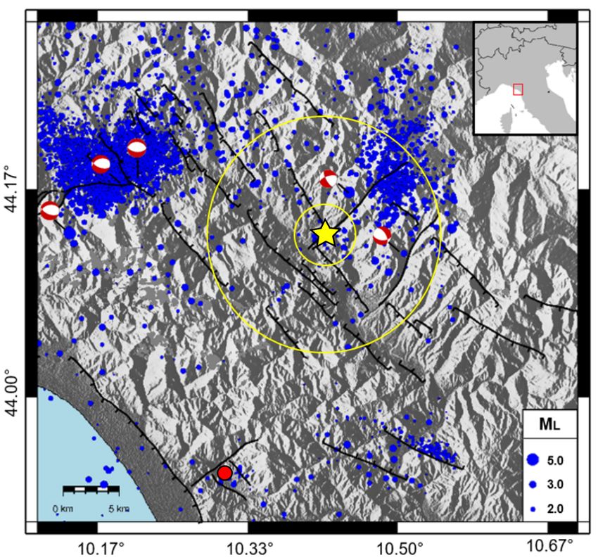
A. La Rosa et al.: Growth of a sinkhole in a seismic zone of the northern Apennines (Italy)                                         2357

Figure 2. Geological setting of the study area. (a) Geological, structural and geomorphological map of the area nearby Prà di Lama showing
the main tectonic and lithostratigraphic units. (b) Schematic sedimentary sequence of the Villafranchian deposits obtained from the well
drilled at Prà di Lama (modified from Chetoni, unpublished data). (c) Stratigraphic cross section across the Garfagnana graben.

   The Prà di Lama sinkhole is located at the intersection be-         3     Data
tween two seismically active faults: the Corfino normal fault
(Di Naccio et al., 2013; ISIDe working group, 2016) and                Century-scale historical records of sinkhole activity are
the right-lateral strike-slip M. Perpoli–T. Scoltenna fault that       available at Prà di Lama and allow us to determine the
recently generated the Mw 4.8 earthquake in January 2013               timescale of sinkhole evolution as well as to characterize
(Fig. 1) (Pinelli, 2013; Molli et al., 2017). Hot water springs        the different events of unrest, in particular the two most re-
are also present at Prà di Lama (Bencini et al., 1977; Gher-           cent events in 1996 and 2016. InSAR time series analysis is
ardi and Pierotti, 2018). Geochemical analyses of the Prà              also carried out to measure ground deformations in the Prà di
di Lama spring waters by Gherardi and Pierotti (2018), ex-             Lama sinkhole in the time period between events of unrest.
panding on previous research (Baldacci et al., 2007), suggest          Finally, the local catalogue of seismicity (ISIDE catalogue,
that both shallow and deep aquifers are present below Prà di           INGV) is used to inform us on the timing and types of brittle
Lama (Fig. 2b). Shallow aquifers have low salinity and low             failures in the area of the sinkhole.
temperature, while waters feeding the thermal springs have
high temperature (∼ 57 ◦ C) and high salinity (5.9 g kgw−1 ),          3.1    Historical record
suggesting the presence of a deep aquifer at ∼ 2000 m into
the anhydrite and the calcareous–dolomitic breccia. The high           The first historical record of the Prà di Lama sinkhole dates
salinity of the deep groundwaters is associated with dissolu-          back to the 991 AD, when the area was described as a sea-
tion of the deep evaporitic formations. Furthermore, unmix-            sonal shallow pool fed by springs. Since then, the depression
ing of deep and shallow waters is interpreted by Gherardi and          grew and several events of unrest consisting of fracturing and
Pierotti (2018) as evidence of their rapid upwelling, likely           fluctuations of the lake level were reported (Raffaelli, 1869;
occurring along the existing faults.                                   De Stefani, 1879, Giovannetti, 1975) (Table 1). In particu-
                                                                       lar, eight events of unrest were reported, giving an average

www.nat-hazards-earth-syst-sci.net/18/2355/2018/                               Nat. Hazards Earth Syst. Sci., 18, 2355–2366, 2018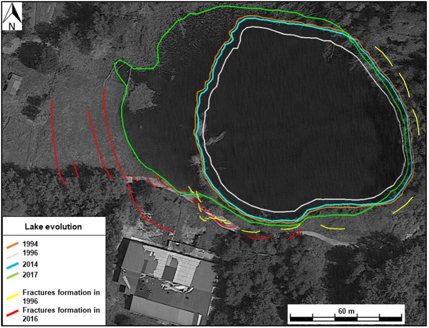
2358                             A. La Rosa et al.: Growth of a sinkhole in a seismic zone of the northern Apennines (Italy)

Figure 3. Evolution of the Prà di Lama lake between 1994 and 2017. Lake shore variation has been retrieved from the analysis of the Landsat
image.

of 1 event of unrest every 26 years. We conducted direct ob-            Table 1. Description of the activity at Prà di Lama lake.
servation of surface deformation around the lake for the two
most recent events in 1996 and 2016.                                     Year          Brief description of the event
   In 1996, the lake level experienced a fall of up to 4 m               991           Seasonal pool fed by springs.
(Figs. 3 and S1 in the Supplement) and at the same time the              1828          Bursts of the spring water flow. Uprising of muddy
springs outside the lake suddenly increased the water out-                             waters and clays (Raffaelli, 1869; De Stefani,
flow. Clay and mud were also ejected by the springs outside                            1879).
the lake, while fractures and slumps occurred within the lake            1843          Bursts of the spring water flow. Uprising of muddy
due to the water drop (Figs. 3 and S1). The unrest lasted ap-                          waters and clays (Raffaelli, 1869; De Stefani,
                                                                                       1879).
proximately 2 months, from March to April 1996. During the
                                                                         1876          Subsidence and fracturing (De Stefani, 1879).
final stages, the water level in the lake rose rapidly, recover-         1877          Subsidence and fracturing (De Stefani, 1879).
ing its initial level, and contemporaneously the spring water            1962          Bursts of the spring water flow. Uprising of muddy
flow reduced.                                                                          waters and clays (Giovannetti, 1975).
   In June 2016, an event of unrest consisting of ground sub-            1969          Abrupt falling of the water level and fracturing
sidence on the western and southern sides of the Prà di Lama                           along the shores. The lake almost disappeared (Gio-
lake started and lasted approximately 9 months, until Febru-                           vannetti, 1975).
                                                                         1985          Arising of muddy waters in a well.
ary 2017. During this period fractures formed and progres-
                                                                         1996          Abrupt fall of the water level and fracturing along
sively grew, increasing their throw to up to 70 cm and affect-                         the shores.
ing a large area on the western side of the lake (Figs. 3 and            2016–2017     Subsidence and fracturing.
S2). Subsidence around the lake resulted in an increase in the
lake surface, in particular on the western side and in the for-
mation of tensile fractures (Figs. 3 and S2). Unlike the 1996
events of unrest, no lake-level changes or increase in water            resolution (Baer et al., 2002; Castañeda et al., 2009; Atzori
flow were observed from the springs around the lake.                    et al., 2015; Abelson et al., 2017). Furthermore, the availabil-
                                                                        ity of relatively long data sets of SAR images in the Apen-
3.2    InSAR                                                            nines allows us to study the behaviour of the Prà di Lama
                                                                        sinkhole using multi-temporal techniques. We processed a
InSAR is ideally suited to monitor localized ground defor-              total of 200 interferograms using SAR images acquired by
mation such as that caused by sinkholes, as it can observe              the ENVISAT satellite between 2003 to 2010 from two dis-
rapidly evolving deformation of the ground at high spatial              tinct tracks in ascending or descending viewing geometry

Nat. Hazards Earth Syst. Sci., 18, 2355–2366, 2018                              www.nat-hazards-earth-syst-sci.net/18/2355/2018/
A. La Rosa et al.: Growth of a sinkhole in a seismic zone of the northern Apennines (Italy) 2359
(tracks 215 and 437). We used the Small BAseline Subset As a final post-processing step we also calculated the verti-
(SBAS) multi-interferogram method originally developed by cal and east–west components of the velocity field in the area
Berardino et al. (2002) and recently implemented for par- covered by both the ascending and descending tracks and as-
allel computing processing (P-SBAS) by Casu et al. (2014) suming no north–south displacement. Given that the study
to obtain incremental and cumulative time series of InSAR area is imaged by the ENVISAT satellite from two symmet-
line-of-sight (LOS) displacements as well as maps of average rical geometries with similar incidence angles (few degrees
LOS velocity. In particular, the InSAR processing has been of difference), the vertical and east–west components of the
carried out via the ESA platform P-SBAS open-access on- velocity field can simply be obtained solving the following
line tool named G-POD (Grid Processing On Demand) that system of equations (Manzo et al., 2006):
allows ground displacement time series to be generated from
a set of SAR data (De Luca et al., 2015). cos ϑ vDESC − vASC
vH =
(vDESC − vASC ) =
The P-SBAS G-POD tool allows the user to set some key sin(2ϑ) 2 sin ϑ
parameters to tune the InSAR processing. In this work, we sin ϑ vDESC + vASC ,
vV =
(vDESC + vASC ) =
set a maximum perpendicular baseline (spatial baseline) of sin (2ϑ) 2 cos ϑ
400 m and maximum temporal baseline of 1500 days. The
geocoded pixel dimension was set to ∼ 80 m by 80 m (corre- where vH and vV are the horizontal and vertical component
sponding to averaging together 20 pixels in range and 4 pix- of the velocity field, vDESC and vASC are the average LOS ve-
els in azimuth). locities in the descending and ascending tracks, respectively;
We initially set a coherence threshold to 0.8 (0 to 1 for low ϑ is the incidence angle.
to high coherence) in order to select only highly coherent The InSAR P-SBAS analysis shows that significant sur-
pixels in our interferograms. The 0.8 coherence threshold is face deformation occurs at Pieve Fosciana between 2003 and
used to select the pixels for the phase unwrapping step that 2010. The observed deformation pattern consists of a range
is carried out by the extended minimum cost flow (EMCF) increase mainly on the western flank of the Prà di Lama lake.
algorithm (Pepe and Lanari, 2006). By setting high values of The range increase is observed in both ascending and de-
this parameter the pixels in input to the EMCF algorithm are scending velocity maps (Fig. 4a, b), with average LOS veloc-
affected by less noise compared to selecting low values, thus ities of up to −7.1 mm yr−1 decaying to −1 mm yr−1 over a
increasing the quality of the phase unwrapping step itself and distance of 400 m away from the lake. Elsewhere around the
reducing the noise in our final velocity maps and time series lake coherence is not kept due to the presence of both crop-
(De Luca et al., 2015; Cignetti et al., 2016). land and woodland cover, leading to decorrelation. However,
We also inspected the series of interferograms and ex- few coherent pixels are identified on the eastern flank of the
cluded individual interferograms with low coherence. We lake, in areas with buildings and sparse vegetation cover, sug-
identified and discarded 29 noisy interferograms in track gesting that the deformation pattern may be circular, with a
215A and other 11 interferograms in track 437D. Finally, we radius of ∼ 600 m (Figs. 4 and 5). In order to increase the
applied an atmospheric phase screen (APS) filtering to miti- number of analysed pixels we tested decreasing our coher-
gate further atmospheric disturbances (Hanssen, 2001). Ac- ence threshold from 0.8 to 0.4. The results are displayed in
cordingly, we used a triangular temporal filter with a width of Fig. S3b and show that only a few more pixels are gained
400 days to minimize temporal variations shorter than about north of the sinkhole compared to choosing a threshold of 0.8
a year as we focus on steady deformations rather than sea- (Fig. 4). We conclude that decreasing the coherence thresh-
sonal changes. A shorter time interval of 300 days was also old does not allow the entire deformation pattern to be re-
tested but provided more noisy time series. trieved, likely due to the fact the area is vegetated.
The average velocity map and the incremental time se- The maps of vertical and east–west velocities show verti-
ries of deformation obtained with the P-SBAS method have cal rates of −4.6 mm yr−1 and horizontal eastward velocities
to be referred to a stable reference point. For our analysis, of 5.4 mm yr−1 (Fig. 4c, d) consistent with subsidence and
the reference point was initially set in the city of Massa be- contraction centred at the lake. Furthermore, Fig. 5 shows
cause GPS measurements from Bennett et al. (2012) show that the current deformation pattern follows the topography,
that the surface velocities there are < 1 mm yr−1 ; therefore, suggesting that subsidence at Prà di Lama is a long-term fea-
Massa can be considered stable. Assuming Massa as a refer- ture. The time series of cumulative LOS displacements show
ence point, the average velocity map revealed the deforma- that subsidence occurred at an approximately constant rate
tion pattern around the Prà di Lama lake. We then moved the between the 2003 and the 2008 but it slowed down in 2008
reference point outside the sinkhole deformation pattern but (Fig. 4e, f), indicating that subsidence at Prà di Lama occurs
close to the village of Pieve Fosciana (Fig. S3a). Selecting a also between events of unrest. Furthermore, our time series
reference point close to our study area rather than in Massa of vertical and east–west cumulative displacements also con-
allowed us to better minimize the spatially correlated atmo- firm that the fastest subsidence and contemporaneous east-
spheric artefacts. ward motion occurred until 2008 (Fig. 4g, h). In order to
better understand the mechanisms responsible for the sink-
www.nat-hazards-earth-syst-sci.net/18/2355/2018/ Nat. Hazards Earth Syst. Sci., 18, 2355–2366, 20182360 A. La Rosa et al.: Growth of a sinkhole in a seismic zone of the northern Apennines (Italy)
Figure 4. (a, b) Maps of average surface velocity and its vertical (c) and east–west (d) components obtained from ENVISAT SAR images
acquired between 2003 and 2010. Negative values indicate a range increase. The white line in panel (a) marks the cross section shown in
Fig. 4. The black star is the point used as a reference for the InSAR-SBAS processing. (e–h) Time series of incremental deformation extracted
from the pixel bounded with the white rectangle.
hole growth and the different types of episodic unrest we also mic moment release and the magnitude content of the earth-
analysed the seismicity. quakes in the area encompassing the sinkhole and the fault
intersection (10 km radius, Fig. 1) to understand whether un-
3.3 Seismicity rest at Prà di Lama is triggered by earthquakes along the ac-
tive faults (Fig. 6). Figure 6a shows that, although several
Seismicity at the Prà di Lama lake was analysed using seismic swarms occurred in the area, no clear temporal cor-
the catalogue ISIDe (Italian Seismological Instrumental and relation between the swarms and the events of unrest at Prà
Parametric Data-Base) spanning the time period from 1986 di Lama is observed, suggesting that the majority of seismic
to 2016. We calculated the cumulative seismic moment re- strain released on faults around the Prà di Lama lake does
lease using the relation between seismic moment and magni- not affect the activity of the sinkhole. We removed from the
tudes given by Kanamori (1977). First, we analysed the seis-
Nat. Hazards Earth Syst. Sci., 18, 2355–2366, 2018 www.nat-hazards-earth-syst-sci.net/18/2355/2018/A. La Rosa et al.: Growth of a sinkhole in a seismic zone of the northern Apennines (Italy) 2361
Figure 5. Cross section of topography and InSAR velocities along the A-A0 profile as shown in Fig. 3a.
Figure 6. Seismicity of an area 10 km in radius around the Prà di
Lama lake. Cumulative seismic moment released in the area (a) and Figure 7. Seismicity of an area 3 km in radius around the Prà di
histograms of the number of earthquakes per month. Three different Lama lake. Plot of the cumulative seismic moment released in the
classes of magnitude have been created: Ml < 2.0 (b), 2.0 < Ml < area (a) and histograms showing the number of earthquakes oc-
3.0 (c) and Ml > 3.0 (d). The data set covers the period between curred each month. Two different classes of magnitude have been
1986 and 2017. The red transparent bars indicate the two events of created: Ml < 2.0 (b), 2.0 < Ml < 3.0 (c). No events of Ml > 3.0
unrest of 1996 and 2016. The orange solid line in panel (a) marks occurred in the area between 1986 and 2017. The red transparent
the Mw 4.8 earthquake, on 25 January 2013. bars indicate the two events of unrest of 1996 and 2016.
magnitude spectrum. This pattern is specific to the sinkhole
plot in Fig. 6a the high-magnitude earthquake, Mw 4.8, on area, because in the broader region (Fig. 6b, c) the major-
the 25 January 2013 in order to better visualize the pattern ity of earthquake magnitudes are in the range Ml > 2 to
of seismic moment release in time. In any case, no activity at Ml < 3 and few with Ml > 3 also occurred. We also anal-
Prà di Lama was reported in January 2013. ysed the hypocentres of the earthquakes around the Prà di
We also analysed the local seismicity around the Prà di Lama lake (3 km radius) and find that these range between
Lama lake, within a circular area of 3 km radius around the 4.5 and 11.5 km depth, indicating that deformation processes
lake (Fig. 1) to better understand the deformation processes in the fault zone control the sinkhole activity. On the other
occurring at the sinkhole and we found that swarms of low- hand, no earthquakes were recorded at Prà di Lama during
magnitude earthquakes (Ml ≤ 2) occurred during both events the period of subsidence identified by InSAR between 2003
of unrest at Prà di Lama in 1996 and 2016 (Fig. 7a, b, c), and 2010, indicating that subsidence between events of un-
while a few earthquakes with magnitudes > 2 occurred ir- rest continues largely aseismically.
respective of the events of unrest. This indicates that seis- To strengthen our seismicity analysis and clarify whether a
micity during sinkhole activity is characterized by seismic connection between major tectonic earthquakes and sinkhole
energy released preferentially towards the lower end of the unrest exists, we also analysed the historical parametric seis-
www.nat-hazards-earth-syst-sci.net/18/2355/2018/ Nat. Hazards Earth Syst. Sci., 18, 2355–2366, 20182362 A. La Rosa et al.: Growth of a sinkhole in a seismic zone of the northern Apennines (Italy)
Figure 8. Comparison between the earthquakes (blue lines) in the Garfagnana area (INGV Catalogo Paramentrico dei Terremoti Italiani
CPTI15, Rovida et al., 2016) and events of unrest at the Prà di Lama sinkhole (red lines). Light grey shading marks the time period covered
by CPT15, while dark grey shading is the period covered by ISIDe.
mic catalogues (Rovida et al., 2016; INGV Catalogo Para- unrest, during the period 2003–2010. Instead swarms of low-
metrico dei Terremoti Italiani, CPTI15). Figure 8 shows the magnitude earthquakes coeval to the unrest events of 1996
occurrence of major earthquakes, with magnitude > 4.0 up and 2016 were recorded at depth between 4.5 and 11.5 km,
to 20 km away from Pieve Fosciana and the events of sink- indicating that a link between low-magnitude seismicity and
hole unrest at Prà di Lama. No clear connection between oc- sinkhole activity exists. We suggest that seismic creep in the
currence of large distant earthquakes and events of sinkhole fault zone underneath Prà di Lama occurs, causing the di-
unrest is observed, suggesting that the mechanisms responsi- verse deformation events.
ble for the activation of the Prà di Lama sinkhole should be Seismic creep at depth could have induced pressure
attributed to local processes. changes in the aquifer above the fault zone (1996 events)
as well as causing subsidence by increased fracturing (2016
events). The seismicity pattern revealed by our analysis sug-
4 Discussion and conclusions gests that the Mt Perpoli–T. Scoltenna strike-slip fault system
underneath Prà di Lama is locally creeping, producing seis-
A multi-disciplinary data set of InSAR measurements, field
mic sequences of low-magnitude earthquakes. Similar seis-
observations and seismicity reveal that diverse deformation
micity patterns were observed along different active faults
events occur at the Prà di Lama sinkhole. Two main events
(i.e. Nadeau et al., 1995; Linde et al., 1996; Rau et al., 2007;
of sinkhole unrest occurred at Prà di Lama in 1996 and 2016
Chen et al., 2008; Harris, 2017). In 2006, along the Supersti-
but the processes had different features. In 1996 the lake
tion Hills fault (San Andreas fault system, California) seis-
level dropped together with increased water outflow from
mic creep has been favoured by high water pressure (Scholz,
the springs, while in 2016 ground subsidence led to the ex-
1998; Wei et al., 2009; Harris, 2017). We suggest that along
pansion of the lake surface and fracturing. In 2016, fractures
the fault zone below Prà di Lama an increase in pressure in
formed on the south-western shore of the lake. The main ac-
the aquifer in 1996 caused fracturing at the bottom of the
tive strike-slip fault is also oriented SW, suggesting a possi-
lake and upward migration of fluids rich in clays, in agree-
ble tectonic control on the deformation.
ment with the observations of lake-level drop and mud-rich
We considered processes not related to the sinkhole ac-
water ejected by the springs in 1996. Our interpretation is
tivity that could explain the observed deformation at Prà di
also in agreement with geochemical data indicating that the
Lama. Active landslides can cause both vertical and horizon-
high salinity of thermal waters at Prà di Lama have a deep
tal surface motions (e.g. Nishiguchi et al., 2017). However,
origin, ∼ 2000 m, where fluid circulation dissolves evapor-
no landslides are identified in the deforming area around the
ites and carbonates, creating cavities and then reaching the
sinkhole (Fig. 3). Furthermore, the low topographic slopes
surface by rapid upwelling along the faults system (Gher-
rule out the presence of active landslides in the area. Con-
ardi and Pierotti, 2018). The presence of deep cavities and a
centric deformation patterns are observed above shallow
thick non-carbonate sequence suggests that the Prà di Lama
aquifers (e.g. Amelung et al., 1999). However, deformation
sinkhole is a deep-sited caprock collapse sinkhole accord-
caused by aquifers have a seasonal pattern rather than contin-
ing to the sinkhole classification of Gutiérrez et al. (2008,
uous subsidence over the timespan of several years, as in Prà
2014). Sudden fracturing and periods of compaction of cavi-
di Lama. A long-term subsidence could only be caused by
ties created by enhanced rock dissolution and upward erosion
over-exploitation of an aquifer but no water is pumped from
in the fluid circulation zone could explain both sudden sub-
the aquifers in the deforming area around Prà di Lama. We
sidence and fracturing, as in 2016, and periods of continuous
conclude that the observed InSAR deformation is caused by
but aseismic subsidence as in 2003–2010. Similar processes
the sinkhole.
have been envisaged for the formation of a sinkhole at the
InSAR analysis shows that continuous but aseismic sub-
Napoleonville Salt Dome, where a seismicity study suggests
sidence of the sinkhole occurred between the two events of
Nat. Hazards Earth Syst. Sci., 18, 2355–2366, 2018 www.nat-hazards-earth-syst-sci.net/18/2355/2018/A. La Rosa et al.: Growth of a sinkhole in a seismic zone of the northern Apennines (Italy) 2363
that fracturing enhanced the rock permeability, promoting the the guidance of FC and CDL. ALR and CP analysed the seismic
rising of fluids and, as a consequence, erosion and creation data. ALR, GM and AP collected structural data around the lake
of deep cavities prone to collapse (Sibson, 1996; Mickleth- from the 2016 event. GD’AA and GM provided the geological, ge-
waite et al., 2010; Nayak and Dreger, 2014; Yarushina et al., omorphological and structural data of the Garfagnana area.
2017). Recently, a sequence of seismic events was identified
at Mineral Beach (Dead Sea fault zone) and was interpreted
as the result of crack formations and faulting above subsur- Competing interests. The authors declare that they have no conflict
of interest.
face cavities (Abelson et al., 2017).
Precursory subsidence of years to a few months has been
observed to precede sinkhole collapse in carbonate or evap-
Acknowledgements. We thank the two anonymous reviewers for
oritic bedrocks (e.g. Baer et al., 2002; Nof et al., 2013; their constructive and useful comments. We thank the European
Cathleen and Bloom, 2014; Atzori et al., 2015; Abelson et Space Agency (ESA) for providing the ENVISAT SAR data used
al., 2017). However, the timing of these processes strongly in this study through the VA4. This work was partially supported
depends on the rheological properties of the rocks (Shalev by the ESA G-POD and GEP projects. Part of the post-processing
and Lyakhovsky, 2012). Furthermore, the presence of a thick was carried out at IREA-CNR through the Infrastructure of High
lithoid sequence in Prà di Lama may delay sinkhole collapse, Technology for Environmental and Climate Monitoring project
also in agreement with the exceptionally long timescale for Structural improvement (I-AMICA-PONa3_00363) financed
(since AD 991) of growth of the Prà di Lama sinkhole under the National Operational Programme (NOP) for “Research
(Shalev and Lykovsky, 2012; Abelson et al., 2017). How- and Competitiveness 2007–2013” and co-funded by European
ever, at present we are not able to establish if and when a Regional Development Fund (ERDF) and national resources. All
processed interferograms are archived at IREA-CNR, Naples.
major collapse will occur in Prà di Lama.
Alessandro La Rosa thanks IREA-CNR, Naples for his InSAR
We identified a wide range of surface deformation patterns
training internship. Carolina Pagli gratefully acknowledges the
associated with the Prà di Lama sinkhole and we suggest that support she received through her Rita Levi Montalcini fellowship
a source mechanism for the sinkhole formation and growth (MIUR Montalcini 26259_21/12/2013). This work was also
is seismic creep in the active fault zone underneath the sink- financially supported by Università di Pisa.
hole. This mechanism could control the evolution of other
active sinkholes in Italy as well as in other areas worldwide Edited by: Mario Parise
where sinkhole form in active fault systems (e.g. Dead Sea Reviewed by: two anonymous referees
area). InSAR monitoring has already been shown to be a
valid method to detect precursory subsidence occurring be-
fore a sinkhole collapse and the recent SAR missions, such as
the European Sentinel-1, will very likely provide a powerful References
tool to identify such deformations.
Abelson, M., Aksinenko, T., Kurzon, I., Pinsky, V., Baer, G., Nof,
R., and Yechieli, Y.: Nanoseismicity forecast sinkhole collapse
Data availability. The DEM data used in this study are from the in the Dead Sea coast years in advance, Geology, 46, 83–86,
SRTM (Shuttle Radar Topography Mission) by JPL (NASA) and https://doi.org/10.1130/G39579.1, 2017.
accessible at https://earthexplorer.usgs.gov (USGS, 2018). The li- Amelung, F., Galloway, D. L., Bell, J. W., Zebker, H. A., and Lacz-
dar DEM data were taken from Regione Toscana through the GEO- niak, R. J.: Sensing the ups and downs of Las Vegas: InSAR re-
scopio webgis portal (http://www502.regione.toscana.it/geoscopio/ veals structural control of land subsidence and aquifer-system de-
cartoteca.html; Regione Toscana, 2018). The seismicity data are formation, Geology, 27, 483–486, https://doi.org/10.1130/0091-
provided by the Istituto Nazionale di Geofisica e Vulcanologia 7613(1999)0272.3.CO;2, 1999.
(INGV) through the Italian Seismological Instrumental and Para- Atzori, S., Baer, G., Antonioli, A., and Salvi, S.: InSAR-
metric Data-Base (ISIDe; INGV, 2016) and the Catalogo Paramet- based modelling and analysis of sinkholes along the
rico dei Terremoti Italiani 2015 (CPTI15) (Rovida et al., 2016). Dead Sea coastline, Geophys. Res. Lett., 42, 8383–8390.
https://doi.org/10.1002/2015GL066053, 2015.
Baer, G., Schattner, U., Wachs D., Sandwell, D., Wdowinski, S.,
and Frydman, S.: The lowest place on Earth is subsiding – An
The Supplement related to this article is available InSAR (Interferomeric Synthetic Aperture Radar) Perspective,
online at https://doi.org/10.5194/nhess-18-2355-2018- Geol. Soc. Am. Bull., 114, 12–23, https://doi.org/10.1130/0016-
supplement. 7606(2002)1142.0.CO;2, 2002.
Baldacci, F., Botti, F., Cioni, R., Molli, G., Pierotti, L., Scozzari,
A., and Vaselli, L.: Geological-structural and hydrogeochemical
Author contributions. ALR, CP and GM planned the work. ALR studies to identify sismically active structures: case history from
drafted the manuscript and prepared the figures with input from all the Equi Terme-Monzone hydrothermal system (Northern Apen-
other authors. Previously unpublished historical data from Prà di nine – Italy), Geoitalia, 6th Italian Forum of Earth Sciences, 12–
Lama were collected by AP. ALR processed the InSAR data under 14 September 2007, Rimini, Italy, 2007.
www.nat-hazards-earth-syst-sci.net/18/2355/2018/ Nat. Hazards Earth Syst. Sci., 18, 2355–2366, 20182364 A. La Rosa et al.: Growth of a sinkhole in a seismic zone of the northern Apennines (Italy) Bencini, A., Duchi, V., and Martini, M.: Geochemistry of thermal De Luca, C., Cuccu, R., Elefante, S., Zinno, I., Manunta, M., Ca- springs of Tuscany (Italy), Chem, Geol„ 19, 229–252, 1977. sola, V., Rivolta, G., Lanari, R., and Casu, F.: An On-Demand Bennet, R. A., Serpelloni, E., Hreinsdottir, S., Brandon, M. T., Bu- Web Tool for the Unsupervised Retrieval of Earth’s Surface ble, G., Basic T., Casale, G., Cavaliere, A., Anzidei, M., Mar- Deformation from SAR Data: The P-SBAS Service within the jonovic, M., Minelli, G., Molli, G., and Montanari, A.: Syn- ESA G-POD Environment, Remote Sensing, 7, 15630–15650, convergent extension observed using the RETREAT GPS net- https://doi.org/10.3390/rs71115630, 2015. work, northern Apennines, Italy, J. Geophys. Res., 117, B04408, De Stefani, C.: Le Acque Termali di Pieve Fosciana, Memorie della https://doi.org/10.1029/2011JB008744, 2012. Società Toscana di Scienze Naturali, 4, 72–97, 1879. Berardino, P., Fornaro, G., Lanari, R., and Sansosti, E.: A new algo- Di Naccio, D., Boncio, P., Brozzetti, F., Pazzaglia, F. J., and rithm for surface deformation monitoring based on Small Base- Lavecchia, G.: Morphotectonic analysis of the Lunigiana and line Differential SAR interferograms, Int. Geosci. Remote Se., Garfagnana grabens (northern Apennines, Italy): Implications 40, 2375–2383, https://doi.org/10.1109/TGRS.2002.803792, for active normal faulting, Geomorphology, 201, 293–311, 2002. https://doi.org/10.1016/j.geomorph.2013.07.003, 2013. Bonini, M., Corti, G., Donne, D. D., Sani, F., Piccardi, L., Van- Doglioni, C.: A proposal for the kinematic modelling of nucci, G., Genco, R., Martelli, L., and Ripepe, M.: Seis- the W-dipping subduction – possible applications to the mic sources and stress transfer interaction among axial nor- Tyrrhenian-Apennines system, Terra Nova, 3, 423–434, mal faults and external thrust fronts in the northern Apen- https://doi.org/10.1111/j.1365-3121.1991.tb00172.x, 1991. nines (Italy): a working hypothesis based on the 1916–1920 Elter, P., Giglia, G., Tongiorgi, M., and Trevisan, L.: Tensional and time-space cluster of earthquakes, Tectonophysics, 680, 67–89, compressional areas in the recent (Tortonian to Present) evolu- https://doi.org/10.1016/j.tecto.2016.04.045, 2016. tion of the Northern Apennines, B. Geofis. Teor. Appl., 42, 3–18, Buchignani, V., D’Amato Avanzi, G., Giannecchini, R., and Puc- 1975. cinelli, A.: Evaporite karst and sinkholes: a synthesis on Faccenna, C., Florindo, F., Funiciello, R., and Lombardi, S.: Tec- the case of Camaiore (Italy), Environ. Geol., 53, 1037-1044, tonic setting and Sinkhole Features: case histories from Western https://doi.org/10.1007/s00254-007-0730-x, 2008. Central Italy, Quat. Proc., 3, 47–56, 1993. Caramanna, G., Ciotoli, G., and Nisio, S.: A review of natural sink- Faccenna, C., Becker, T. W., Auer, L., Billi, A., Boschi, L., Brun, hole phenomena in Italian plain areas, Nat. Hazards, 45, 145– J., Capitanio, F. A., Funiciello, F., Horvàth, F., Jolivet, L., Piro- 172, https://doi.org/10.1007/s11069-007-9165-7, 2008. mallo, C., Royden, L., Rossetti, F., and Serpelloni, E.: Man- Castañeda, C., Gutiérrez, F., Manunta, M., and Galve, J. P.: DIn- tle dynamics in the Mediterranean, Rev. Geophys., 52, 28–332, SAR measurements of ground deformation by sinkholes, mining https://doi.org/10.1002/2013RG000444, 2014. subsidence, and landslides, Ebro River, Spain, Earth Surf. Proc. Florea, L. J.: Using State-wide GIS data to identify the coincidence Land., 34, 1562–1574, https://doi.org/10.1002/esp.1848, 2009. between sinkholes and geologic structure, J. Cave Karst Stud., Casu, F., Elefante, S., Imperatore, P., Zinno, I., Manunta, M., De 67, 120–124, 2005. Luca, C., and Lanari, R: SBAS-DInSAR parallel processing for Ford, D. C. and Williams, P.: Karst Hydrogeology and Geomorphol- deformation time-series computation, IEEE J. Sel. Top. Appl., ogy, Wiley, Chichester, UK, 562 pp., 2007. 7, 3285–3296, https://doi.org/10.1109/JSTARS.2014.2322671, Frumkin, A. and Raz, E.: Collapse and subsidence associated with 2014. salt karstification along the Dead Sea, Carbonate. Evaporite., 16, Cathleen, J. and Blom, R.: Bayou Corne, Louisiana, sinkhole: Pre- 117–130, https://doi.org/10.1007/bf03175830, 2001. cursory deformation measured by radar interferometry, Geology, Gherardi, F. and Pierotti, L.: The suitability of the Pieve Fos- 42, 111–114, https://doi.org/10.1130/G34972.1, 2014. ciana hydrothermal system (Italy) as a detection site for geo- Chen, K. H., Nadeau, R. M., and Rau, R.: Characteristic repeat- chemical seismic precursors, Appl. Geochem., 92, 166–179, ing earthquakes in an arc-continent collision boundary zone: The https://doi.org/10.1016/j.apgeochem.2018.03.009, 2018. Chihshang fault of eastern Taiwan, Earth Planet. Sc. Lett., 276, Giovannetti, F.: Pieve Fosciana Ieri e Oggi, Amministrazione co- 262–272, https://doi.org/10.1016/j.epsl.2008.09.021, 2008. munale di Pieve Fosciana, Lucca, Italy, 51 pp., 1975. Cignetti, M., Manconi, A., Manunta, M., Giordan, D., De Luca, C., Gutierréz, F., Guerrero, J., and Lucha, P.: A genetic clas- Allasia, P., and Ardizzone, F.: Taking Advantage of the ESA G- sification of sinkholes illustrated from evaporite pale- POD Service to Study Ground Deformation Processes in High okarst exposures in Spain, Environ. Geol., 53, 993–1006, Mountain Areas: A Valle d’Aosta Case Study, Northern Italy, Re- https://doi.org/10.1007/s00254-007-0727-5, 2008. mote Sensing, 8, 852, https://doi.org/10.3390/rs8100852, 2016. Gutierréz, F., Parise, M., De Waele J., and Jourde, H.: Closson, D.: Structural control of sinkholes and subsidence hazards A review on natural and human-induced geohazards along the Jordanian Dead Sea coast, Environ. Geol., 47, 290– and impacts in karst, Earth-Sci. Rev., 138, 61–88, 301, https://doi.org/10.1007/s00254-004-1155-4, 2005. https://doi.org/10.1016/j.earscirev.2014.08.002, 2014. Closson, D., Karaki, N. A., Klinger, Y., and Hussein, M. J.: Hanssen, R. F.: Radar Interferometry: Data Interpreta- Subsidence and Sinkhole Hazard Assessment in the Southern tion and Error Analysis, Kluwer Academic Publisher, Dead Sea Area, Jordan, Pure Appl. Geophys., 162, 221–248, https://doi.org/10.1007/0-306-47633-9, 2001. https://doi.org/10.1007/s00024-004-2598-y, 2005. Harris, R. A.: Large earthquakes and creeping faults, Rev. Del Prete, S., Iovine, G., Parise, M., and Santo, A.: Ori- Geophys., 55, 169–198, https://doi.org/10.1002/2016RG000539, gin and distribution of different types of sinkholes in the 2017. plain areas of Southern Italy, Geodin. Acta, 23, 113–127, Harrison, R. W., Newell, W. L., and Necdet, M.: Karstification https://doi.org/10.3166/ga.23.113-127, 2010. Along an Active Fault Zone in Cyprus, U.S. Geological Survey Nat. Hazards Earth Syst. Sci., 18, 2355–2366, 2018 www.nat-hazards-earth-syst-sci.net/18/2355/2018/
A. La Rosa et al.: Growth of a sinkhole in a seismic zone of the northern Apennines (Italy)                                                2365

   Water-Resources Investigations Report 02-4174, Atlanta, Geor-            ysis using PALSAR-2 data, Landslides, 14, 1483–1490,
   gia, USA, 2002.                                                          https://doi.org/10.1007/s10346-017-0821-z, 2017.
Istituto Nazionale di Geofisica e Vulcanologia (INGV): Italian Seis-     Nisio, S.: The sinkholes in the Tuscany Region, in: Natu-
   mological Instrumental and Parametric Data-Base, ISIDe work-             ral sinkhole phenomena in the Italian plain area, Mem-
   ing group, version 1.0, https://doi.org/10.13127/ISIDe, 2016.            orie descrittive della carta geologica d’Italia, 85, Isti-
Johnson, A. G., Kovach, R. L., and Nur, A.: Pore pressure changes           tuto Superiore per la Protezione e la Ricerca Ambien-
   during creep events on the San Andreas Fault, J. Geophys. Res.,          tale, Servizio Geologica d’Italia, 213–268, available at:
   78, 851–857, https://doi.org/10.1029/JB078i005p00851, 1973.              http://www.isprambiente.gov.it/it/pubblicazioni/periodici-
Kanamori, H.: The Energy Release in Great Earth-                            tecnici/memorie-descrittive-della-carta-geologica-ditalia/i-
   quakes,       J.     Geophys.       Res.,     82,       2981–2987,       fenomeni-naturali-di-sinkhole-nelle-aree-di           (last    access:
   https://doi.org/10.1029/JB082i020p02981, 1977.                           11 September 2018), 2008.
Kawashima, K., Aydan, O., Aoki, T., Kishimoto, I., Konagal, K.,          Nof, R. N., Baer, G., Ziv, A., Raz, E., Atzori, S., and
   Matsui, T., Sakuta, J., Takahashi, N., Teodori, S.-P., and Yashima,      Salvi, S.: Sinkhole precursors along the Dead Sea, Israel,
   A.: Reconnaissance investigation on the damage of the 2009               revealed by SAR interferometry, Geology, 41, 1019–1022,
   L’Aquila, Central Italy earthquake, J. Earthq. Eng., 14, 817–841,        https://doi.org/10.1130/G34505.1, 2013.
   https://doi.org/10.1080/13632460903584055, 2010.                      Parise, M. and Vennari, C.: A chronological catalogue of sinkholes
Le Breton, E., Handy, M., Molli, G., and Ustaszewski K.:                    in Italy: the first step toward a real evaluation of the sinkhole haz-
   Post-20 Ma Motion of the Adriatic Plate: New Con-                        ard, in: Sinkholes and the Engineering and Environmental Im-
   straints from Surrounding Orogens and Implications                       pacts of Karst: Proceedings of the Thirteenth Multidisciplinary
   for Crust-Mantle Decoupling, Tectonics, 36, 3135–3154,                   Conference, edited by: Land, L., Doctor, D. H., and Stephen-
   https://doi.org/10.1002/2016TC004443, 2017.                              son, J. B., NCKRI Symposium 2, 6–10 May 2013, Carlsbad,
Linde, A. T., Gladwin, M. T., Johnston, M. J. S., Gwyther, R. L., and       New Mexico, USA, National Cave and Karst Research Institute,
   Bilham, R. G.: A slow earthquake sequence on the San Andreas             Carlsbad (NM), https://doi.org/10.5038/9780979542275.1149,
   fault, Nature, 383, 65–68, https://doi.org/10.1038/383065a0,             2013.
   1996.                                                                 Parise, M., Perrone, A., Violante, C., Stewart, J. P., Simonelli,
Manzo, M., Ricciardi, G. P., Casu F., Ventura, G., Zeni, G.,                A., and Guzzetti, F.: Activity of the Italian National Re-
   Borgström S., Berardino, P., Del Gaudio, C., and Lanari, R.:             search Council in the aftermath of the 6 April 2009 Abruzzo
   Surface deformation analysis in th Ischia Island (Italy) based           earthquake: the Sinizzo Lake case study, Proc. 2nd Int.
   on spaceborne radar interferometry, J. Volcanol. Geoth. Res.,            Workshop “Sinkholes in the Natural and Anthropogenic En-
   151, 399–416, https://doi.org/10.1016/j.jvolgeores.2005.09.010,          vironment”, 3–4 December 2009, Rome, Italy, 623–641,
   2006.                                                                    https://doi.org/10.13140/2.1.3094.1127, 2010.
Meletti, C., Patacca, E., and Scandone P.: Construction of a Seis-       Patacca, E. and Scandone, P.: Post-Tortonian mountain building in
   motectonic Model: The Case of Italy, Pure Appl. Geophys., 157,           the Apennines, the role of the passive sinking of a relic litho-
   11–35, https://doi.org/10.1007/PL00001089, 2000.                         spheric slab, in: The Lithosphere in Italy, Advances in Earth Sci-
Micklethwaite, S., Sheldon, H. A., and Baker, T.: Active fault              ence Research, 5–6 May 1987, Rome, Itlay, 157–176, 1989.
   and shear processes and their implications for mineral de-            Pepe, A. and Lanari, R.: On the extension of the minimum cost
   posit formation and discovery, J. Struc. Geol., 32, 151–165,             flow algorithm for phase unwrapping of multitemporal differ-
   https://doi.org/10.1016/j.jsg.2009.10.009, 2010.                         ential SAR interferograms, IEEE T. Geosci. Remote, 44, 2374–
Molli, G., Torelli, L., and Storti, F.: The 2013 Lunigiana (Central         2383, https://doi.org/10.1109/TGRS.2006.873207, 2006.
   Italy) earthquake: Seismic source analysis from DInSar and seis-      Pezzo, G., Boncori, J. P. M., Atzori, S., Piccinini, D., An-
   mological data, and geodynamic implications for the northern             tonioli, A., and Salvi, S.: The 2013 Lunigiana (Cen-
   Apennines. A discussion, Tectonophysics, 668–669, 108–112,               tral Italy) earthquake: Seismic source analysis from DIn-
   https://doi.org/10.1016/j.tecto.2015.07.041, 2016.                       SAR and seismological data, and geodynamical implications
Molli, G., Pinelli, G., Bigot, A., Bennett, R., Malavieille, J., and        for the northern Apennines, Tectonophysics, 636, 315–324,
   Serpelloni, E.: Active Faults in the inner northern Apennines:           https://doi.org/10.1016/j.tecto.2014.09.005, 2014.
   a multidisciplinary reappraisal. From 1997 to 2016: Three De-         Pinelli, G.: Tettonica recente e attiva nell’Appennino interno a Nord
   structive Earthquakes along the Central Apennnine Fault system,          dell’Arno: una revisione delle strutture e delle problematiche,
   Camerino, Italy, 19–22 July 2017, Abstract Volume, p. 29, 2017.          Diploma Thesis, Dipartimento di Scienze della Terra, Università
Nadeau, R. M., Foxal, W., and McEvilly, T. V.: Clustering and               di Pisa, Italy, 89 pp., 2013.
   Periodic Recurrence of Microearthquakes on the San An-                Raffaelli, R.: Sulle acque termali di Pieve Fosciana in Garfagnana,
   dreas Fault at Parkfield, California, Science, 267, 503–507,             Memoria diretta al Consiglio Provinciale di Massa, Tipografia
   https://doi.org/10.1126/science.267.5197.503, 1995.                      dei fratelli Nistri, Pisa, Italy, 23 pp., 1869.
Nayak, A. and Dreger, D. S.: Moment Tensor Inversion of Seis-            Rau, R., Chen, K. H., and Ching, K.: Repeating earthquakes
   mic Events Associated with the Sinkhole at Napoleonville Salt            and seismic potential along the northern Longitudinal Val-
   Dome, Louisiana, B. Seismol. Soc. Am., 104, 1763–1776,                   ley fault of Taiwan, Geophys. Res. Lett., 34, L24301,
   https://doi.org/10.1785/0120130260, 2014.                                https://doi.org/10.1029/2007GL031622, 2007.
Nishiguchi, T., Tsuchiya, S., and Imaizumi, F.: Detection                Regione Toscana: GEOscopio, Direzione urbanistica e poitivhe
   and accuracy of landslide movement by InSAR anal-                        abitative, Settore Sistema Informativo Territoriale ed Ambien-

www.nat-hazards-earth-syst-sci.net/18/2355/2018/                                 Nat. Hazards Earth Syst. Sci., 18, 2355–2366, 2018
2366                              A. La Rosa et al.: Growth of a sinkhole in a seismic zone of the northern Apennines (Italy)

  tale, available at: http://www502.regione.toscana.it/geoscopio/       Sibson, R. H.: Structural permeability of fluid-driven
  cartoteca.html, last access: 11 September 2018.                          fault-fracture meshes. J. Struct. Geol., 18, 1031–1042,
Rovida, A., Locati, M., Camassi, R., Lolli, B., and Gasperini, P.          https://doi.org/10.1016/0191-8141(96)00032-6, 1996.
  (Eds.): CPTI15, the 2015 version of the Parametric Catalogue of       Stramondo, S., Vannoli, P., Cannelli, V., Polcari, M., Melini,
  Italian Earthquakes, Istituto Nazionale di Geofisica e Vulcanolo-        D., Samsonov, S., Moro, M., Bignami, C., and Saroli,
  gia, https://doi.org/10.6092/INGV.IT-CPTI15, 2016.                       M.: X- and C-band SAR surface displacement for the
Salamon, A.: Seismically induced ground effects of the February            2013 Lunigiana earthquake (Northern Italy): a breached
  11, 2004, ML = 5.2, North-eastern Dead Sea earthquake, The               relay ramp?, IEEE J. Sel. Top. Appl., 7, 2746–2753,
  Ministry of National Infrastructures, Geological Survey of Israel,       https://doi.org/10.1109/JSTARS.2014.2313640, 2014.
  Open File Report GSI/30/04, 25 pp., available at: http://www.         Tertulliani, A. and Maramai, A.: Macroseismic evidence and site
  isprambiente.gov.it/files/progetti/inqua/report-final.pdf (last ac-      effects for the Lunigiana (Italy) 1995 Earthquake, J.Seismol., 2,
  cess: 11 September 2018), 2004.                                          209–222, https://doi.org/10.1023/A:1009734620985, 1998.
Santo, A., Del Prete, S., Di Crescenzo, G., and Rotella, M.: Karst      U.S. Geological Survey (USGS): EarthExplorer, U.S. Department
  processes and slope instability: some investigations in the car-         of the Interior, available at: https://earthexplorer.usgs.gov, last
  bonate Apennine of Campania (southern Italy), in: Natural and            access: 11 September 2018.
  Anthropogenic Hazards in Karst Areas: Recognition, Analysis,          Wadas, S. H., Tanner, D. C., Polom, U., and Krawczyk, C.
  and Mitigation, edited by: Parise, M. and Gunn, J., Geological           M.: Structural analysis of S-wave seismics around an ur-
  Society, London, 279, 59–72, https://doi.org/10.1144/SP279.6,            ban sinkhole: evidence of enhanced dissolution in a strike-
  2007.                                                                    slip fault zone, Nat. Hazards Earth Syst. Sci., 17, 2335–2350,
Scholz, C. H.: Earthquakes and friction laws, Nature, 391, 37–42,          https://doi.org/10.5194/nhess-17-2335-2017, 2017.
  https://doi.org/10.1038/34097, 1998.                                  Wei, M., Sandwell, D., and Fialko, Y.: A silent Mw 4.7
Serpelloni, E., Anzidei, M., Baldi, P., Casula, G., and Galvani, A.:       slip event of October 2006 on the Superstition Hills
  Crustal velocity and strain -rate fields in Italy and surround-          fault, southern California, J. Geophys. Res., 114, B07402,
  ing regions: New results from the analysis of permanent and              https://doi.org/10.1029/2008JB006135, 2009.
  non-permanent GPS networks, Geophys. J. Int., 161, 861–880,           Yarushina, V. M., Podladchikov, Y. Y., Minakov, A., and
  https://doi.org/10.1111/j.1365-246X.2005.02618.x, 2005.                  Räss, L.: On the Mechanisms of Stress-Triggered Seismic
Shalev, E. and Lyakhovsky, V.: Viscoelastic damage mod-                    Events during Fluid Injection, in: Sixth Biot Conference
  elling of sinkhole formation, J. Struct. Geol., 42, 163–170,             on Poromechanics, 9–13 July 2017, Paris, France, 795–800,
  https://doi.org/10.1016/j.jsg.2012.05.010, 2012.                         https://doi.org/10.1061/9780784480779.098, 2017.

Nat. Hazards Earth Syst. Sci., 18, 2355–2366, 2018                              www.nat-hazards-earth-syst-sci.net/18/2355/2018/
You can also read