Guidelines for Public Transport Capable Infrastructure in Greenfield Sites - A guide to delivering public transport capable road design in ...
←
→
Page content transcription
If your browser does not render page correctly, please read the page content below
July 2018

Guidelines for
Public Transport
Capable Infrastructure
in Greenfield Sites
A guide to delivering public
transport capable road design
in greenfield sites.

July 2018 | Version 1
Contents
1   Introduction                                                                        3
    1.1   Purpose                                                                        3
    1.2   Background                                                                    4
    1.3   Objectives of the guidelines                                                  4
2 Strategic principles                                                                   5
    2.1   Road network is influenced by public transport network requirements            5
    2.2   Public transport services are available when residents move in                 5
    2.3   Changes to public transport services maintain usage by existing customers      6
    2.4   Infrastructure is flexible and adaptable for future requirements               6
3 Planning model                                                                         7
    3.1   Role of Transport for NSW                                                      7
    3.2   Working with Transport for NSW                                                 7
    3.3   Road network design                                                            7
    3.4   Road release planning                                                          8
    3.5   Public transport route plan                                                    8
    3.6   Interchange and precinct planning                                              9
    3.7   Green travel plans                                                             9
    3.8   Active transport                                                               9
4 Road infrastructure requirements                                                      10
    4.1   Lane widths                                                                   10
    4.2   Traffic calming devices                                                       11
    4.3   Access ramps                                                                  12
    4.4   Bus stop placement                                                            12
5 References                                                                            13
6 Glossary                                                                              14
Appendix 1 – C
              hecklist of Action – Guidelines for Public Transport Infrastructure in
             Greenfield Sites                                                           15
Appendix 2 – Movement and Place Framework                                               20
Appendix 3 – Policy Context                                                             21
Appendix 4 – Service Coverage Guidelines                                                23
Appendix 5 – Green Travel Plans                                                         24
Appendix 6 – Bus Fleet Specifications                                                   25

Author:      Integrated Planning
Date:        July 2018
Version:     1
Reference:   -
Division:    Infrastructure and Services
1 Introduction
By 2036 NSW will need homes for an additional 2.2 million residents. Sydney alone will need an
extra 725,000 new homes over the next 20 years to keep pace with demand. By 2056 Greater
Sydney will have a population of 8 million people and be transformed into a metropolis of three
cities – the Western Parkland City, the Central River City and the Eastern Harbour City, with the
vision of people living within 30 minutes or their jobs, education and health facilities, services and
great places. Many of the homes required to meet this growth will be built in new land release areas,
known as greenfield sites. A greenfield describes land not previously developed that is suitable for
urban development.
The provision of public transport services at greenfield sites is critical to avoid the economic
cost of congestion and a negative impact on the liveability of the city. Public transport services
are also key to achieving the Government’s customer and network outcomes for NSW: customer
focused, successful places, growing the economy, safety and performance, accessible services and
sustainable. Transport can enhance the liveability, amenity and economic success of communities
and places by managing the road network in a way that enhances the liveability and amenity of
places1. Clear and targeted guidance will ensure that all participants in the development cycle are
providing public transport capable infrastructure from the outset in line with the Government’s
customer and network outcomes.
1.1 Purpose
The Guidelines for Public Transport Capable Infrastructure in Greenfield Sites provide guidance to
planners and developers to support good road design in greenfield sites so that public transport
can be successfully delivered now and into the future. The guidelines address both the road network
design and the road infrastructure requirements.
The guidelines are intended for use by planners including Transport for NSW, the Department of
Planning and Environment, local government, road authorities and developers. Appendix 1 is a list
of all actions from the Guidelines. Planners are encouraged to use this as a checklist.
1 Information on the Movement and Place framework is provided at Appendix 2
Guidelines for Public Transport Capable Infrastructure in Greenfield Sites – July 2018 Page 31.2 Background
Transport for NSW is the transport authority of the NSW Government providing an integrated
approach to the planning and delivery of safe, reliable and efficient transport. A key role of
Transport for NSW is the planning and procurement of transport services.
As greenfield sites have been developed in Sydney and across NSW a need has emerged for
Transport for NSW to clearly document its expectations of the infrastructure required for areas
to be public transport capable now and into the future.
These guidelines were written for greenfield sites but the same principles can be applied to
brownfield sites or any development site. The principles set out here are considered universal
however development in other environments will need to consider further matters such as site
contamination in brownfield sites.
1.3 Objectives of the guidelines
This document sets out the components of road network design that will allow for efficient and
reliable public transport service delivery that can be integrated into the broader transport network.
Road network design refers to the road layout and how this influences the flow of traffic both within
and beyond the boundaries of the greenfield site.
This document also sets out the road infrastructure requirements which allow for provision of a safe
and sustainable public transport service. Road infrastructure refers to the physical structure of the
road, including associated facilities such as footpaths, kerb and guttering and median strips.
The objectives of the guidelines are to:
• define the strategic principles and policy context
• provide guidance on designing and delivering a road network that is public transport capable
• provide guidance on building road infrastructure that is public transport capable
• future proof public transport provision
Guidelines for Public Transport Capable Infrastructure in Greenfield Sites – July 2018 Page 42 Strategic principles
The guidelines for public transport capable infrastructure include a set of strategic principles
that are common across all greenfield sites. Other considerations may need to be made for
individual sites. The strategic principles provide an overarching framework for the performance
of infrastructure in greenfields with a focus on flexibility and adaptability to cater for future
requirements. The policy context that guides the strategic principles can be found at Appendix 3.
2.1 Road network is influenced by public transport network requirements
The requirements of the public transport network need to be considered prior to the design of
a road network. Considerations include a network of streets, clearly distinguished by function.
The table below outlines the different types of roads and their function. Buses generally operate
on collector roads or arterial roads. Therefore a network of collector or arterial roads should be
planned to service the whole site.
Austroads Urban Road Functional Classification
Type of road Function
Controlled access Motorways and freeways have an exclusive function to carry traffic
highways (motorways within cities and to ensure the continuity of the national or regional
or freeways) primary road system. As they are designed to accommodate
through traffic, they do not offer pedestrian or frontage access.
Urban arterial roads Urban arterial roads have a predominant function to carry traffic but
also serve other functions. They form the primary road network and
link main districts of the urban area. Arterial roads that perform a
secondary function are sometimes referred to as sub-arterial roads.
Urban collector / These are local streets that have a greater role than others in
distributor roads connecting contained urban areas (eg residential areas, activity
areas) to the arterial road system. Generally, consideration of
environment and local life predominate and improved amenity is
encouraged over the use of vehicles on these roads.
Urban local roads These are roads intended exclusively for access with no through
traffic function.
Source: Austroads, 2015
2.2 Public transport services are available when residents move in
As greenfield development is often located on the periphery of the urban area it is important to
ensure an adequate public transport service in order to develop a public transport culture and avoid
a strong reliance on cars.
In urban development areas, public transport services should be available to residents as early as
possible after they move in. The early introduction of services provides residents with an alternative
to car use and helps to establish public transport use in the area.2
2 Integrated Public Transport Service Planning Guidelines – Sydney Metropolitan Area and Outer Metropolitan Area
Guidelines for Public Transport Capable Infrastructure in Greenfield Sites – July 2018 Page 52.3 Changes to public transport services maintain usage by
existing customers
Greenfield sites offer some unique challenges when planning public transport service delivery as
there may be few or no existing services in the surrounding area. Where services do exist changes
to travel should not discourage existing customers away from services. Changes to existing
public transport routes need to consider increases in travel time, impacts of changes to origin or
destination, changes to service frequency and avoiding circuitous routes. Where new services are
introduced consideration should be given to how they connect to the surrounding area and the
potential to introduce services to surrounding areas.
2.4 Infrastructure is flexible and adaptable for future requirements
Currently buses operate on collector roads and/or arterial roads. Consideration needs to be given
to what the future road requirements will be for transport. This may include increased opportunities
for on demand transport services operating on local roads using smaller vehicles or smaller vehicles
operating more flexibly. It may also include the need for bus priority measures as both demand
for bus travel and road congestion increases. The road network design will need to allow for this.
Consideration would include ensuring roads are connecting, limiting the use of cul-de-sacs and
ensuring services can stop safely at a greater number of locations.
Alternatively in the future on key routes higher capacity vehicles operating to a fixed route may
be used, such as double-decker buses, requiring greater height clearances3. Consideration of the
streetscape would include the height of infrastructure along the road, the types of trees planted,
the type of street lighting used and built form, such as awnings. Infrastructure should be built in
a way that does not limit future public transport delivery options.
3 Vertical clearance of 4.3m is required
Guidelines for Public Transport Capable Infrastructure in Greenfield Sites – July 2018 Page 63 Planning model
The planning model provides guidance on designing a road network that is public transport friendly
and aligned with the movement and place framework.
3.1 Role of Transport for NSW
The role of Transport for NSW is to lead the development of a safe, efficient, integrated transport
system that keeps people and goods moving, connects communities and shapes the future of our
cities, centres and regions.
In greenfield sites Transport for NSW needs to be involved during the master planning stage or
during the development of the indicative land use plan. During this stage Transport for NSW looks
at the road layout to ensure that an appropriate road network is being provided along potential
future public transport routes. It is important to note that this planning process is separate from the
funding process for public transport services and does not guarantee the delivery of a service along
the identified roads.
Transport for NSW is responsible for planning, approving and funding public transport services.
Once road infrastructure is in place and building work is scheduled, consideration is given to
introducing services. It is important that Transport for NSW is informed by local council, the road
authority or the developer of infrastructure works well prior to completion to enable appropriate
time for consideration of services in the funding process.
In rural and regional NSW where significant growth and infrastructure is being introduced Transport
for NSW may need to review the contract type under which services will be operated. As the timing
of contract changes may be dependent on the contract cycle Transport for NSW needs to be
involved from the master planning stage to allow sufficient time for this to occur.
3.2 Working with Transport for NSW
Transport for NSW needs to be involved in all stages of planning and construction, including
• strategic planning
• planning proposal
• DA stage, including any modifications
• construction
• residents and employees move in
It is strongly recommended that the relevant planner, local government, road authority or developer
contact Transport for NSW at each stage to ensure the alignment of road design with transport needs.
3.3 Road network design
The layout of the road network needs to reflect the requirements of the public transport network:
• collector and arterial roads need to support direct routes and connectivity both within the
greenfield site and to the surrounding area.
• the road and verge width need to be appropriate to allow roads to perform their designated
functions in the road network (see section 4 for road infrastructure requirements)
The layout of the road network also needs to consider land use:
• key trip generators, such as schools and hospitals, are adequately supported by the road network
Guidelines for Public Transport Capable Infrastructure in Greenfield Sites – July 2018 Page 7The road network needs to balance the capability of a direct route with the requirement to minimise
the walking distance to stops. This can be achieved by:
• creating shorter block lengths to increase neighbourhood permeability
• collector roads support direct routes and are not circuitous
• balancing directness of routes with minimisation of walking distance
• providing connected roads rather than cul-de-sacs
Consideration needs to be given to how the greenfield road network interacts with the existing
surrounding road network:
• collector roads in greenfield sites should, at a minimum, connect with a collector road in the
surrounding road network
The design of the road network needs to consider the comfort of customers, the efficiency of the
route and bus swept path movements. Where the introduction of a direct road may encourage
unwanted general traffic, consideration should be given to bus only facilities.
3.4 Road release planning
During greenfield development, land may be released in stages. It is important that public transport
services can be delivered throughout the various build stages with public transport services
remaining attractive to both existing and new customers and as close as possible to the final
offering. This can be achieved by:
• considering the order in which roads are built and land is released to ensure transport services
can be provided during all stages
• ensuring there is access for existing services where they are disrupted by development activity
• ensuring multiple points of entry and exit to the site during construction
• considering opening through routes from the earliest possible stage, even if these are only
accessible to public transport
3.5 Public transport route plan
When designing the road network it is recommended to work with Transport for NSW to devise
a draft route plan to ensure that the road network meets the public transport route planning
requirements. A route plan shows the network of routes that may be offered in an area and the
roads on which these would operate.
In metropolitan Sydney, outer metropolitan Sydney, regional cities and urban areas service coverage
guidelines are in place to support the provision of a minimum service level to the majority of
households. The guidelines are to be considered as a starting point when determining service
coverage. The service coverage guidelines are at Appendix 4.
Issues to consider when developing a public transport route plan include:
• applying the Transport for NSW service coverage guidelines for the area in which the greenfield
is located
• avoiding circuitous or overly long routes that are unattractive to customers
• avoiding loop routes, which require customers to travel additional distances
• how will the proposed routes connect with patronage generators, both within the local area
and surrounding areas
• how will the proposed routes connect with existing or known future public transport
Additional information on how service planning is undertaken can be found in the Transport
for NSW Service Planning Guidelines.
Guidelines for Public Transport Capable Infrastructure in Greenfield Sites – July 2018 Page 83.6 Interchange and precinct planning
Public transport needs to link to an interchange, allowing customers to access the broader transport
network. An interchange may be developed in a greenfield site or an existing interchange, external
to the site, may be the focus for transport services. An interchange is a facility that allows for
transfer from one mode of transport, or one transport service, to another. An interchange may be
a single bus stop or a major train station.
Where an interchange is developed in a greenfield site the following should be considered:
• how does the interchange integrate with the surrounding urban area to create a precinct,
reinforcing transport’s civic and social role as a focal point in centres
• develop a road network that allows entry and exit from multiple points within the precinct
• where are stops located, to allow for infiltration into the centre of the precinct
• is layover space required for buses
Where an existing interchange, external to the greenfield site, is to be the focus for transport
services the following factors should be considered:
• is the road network from the greenfield site to the interchange direct
Interchanges in rural and regional areas are of particular significance as they provide a gateway
to the rail and coach networks, providing access to intra- and inter-regional travel.
3.7 Green travel plans
Walking and cycling are the preferred transport choice for short trips. Facilitating these modes,
along with other sustainable modes of transport, reduces congestion on the road network and
maximises the value of public transport when walking and cycling are integrated into public
transport service planning.
A green travel plan identifies and promotes ways to encourage a range of sustainable or less
environmentally damaging transport modes, usually with the emphasis on reducing single user
private car travel.
A green travel plan should be developed for the greenfield site. The total door-to-door journey
needs to be considered. Information on what should be included in a green travel plan is available
at Appendix 5.
3.8 Active transport
Road network design in greenfield sites needs to consider the requirements of all road users,
including cyclists, pedestrians and other non-motorised traffic of all age groups.
Cyclists and pedestrians are particularly vulnerable road users. Road network design for such users
will seek to facilitate their movements by separating them from motor vehicles in time and space.
It is not always possible, or desirable, to clearly separate vehicular and pedestrian activity. In some
instances where traffic flow and speed are low the provision of shared areas is a preferred approach,
utilising facilities such as ‘shared zones’ and ‘shared spaces’.
Streets and suburbs should be planned so that residents can comfortably walk to the shops for
their daily needs and to key facilities such as schools. For longer journeys the environment should
encourage walking and cycling for part of the journey. In order to promote active transport the
following needs to be considered:
• positive experience when walking and cycling
• shade and amenity along walking and cycling paths
• safety
• what facilities are required where active transport meets public transport
• active transport links should be considered and maintained during construction
Guidelines for Public Transport Capable Infrastructure in Greenfield Sites – July 2018 Page 94 Road infrastructure requirements
The road infrastructure requirements provide guidance on building a road network that is public
transport capable and supports a safe and sustainable public transport service. These guidelines
intend to highlight public transport requirements in greenfield sites and do not replace existing
guidelines. Road infrastructure requirements differ depending on the function of the road, the lane
arrangement, single or multilane, and the road speed.
While these road infrastructure requirements highlight public transport there is an assumption
that if these requirements are met roads will also support other transport types such as trucks
and freight movement. Bus fleet specifications can be found at appendix 6.
4.1 Lane widths
The following lane widths are required to allow a bus service to operate safely and efficiently.
Traffic lanes are measured from the face of the kerb or to the lane line for multi-lane roads or roads
with shoulders.
Traffic lanes
• minimum 3.5m standard traffic lane widths are desirable on all road types
• minimum 3.5m traffic lane width for a 60km zone
• minimum 3.2m traffic lane width for a 50km zone, provided there is no centre median
Kerb side lanes
• minimum width of 3.5m where the kerb side lane operates as a travel lane, to allow buses to use
the lane without passing over drainage structures
• minimum width of 3.0m where the kerb side lane operates as a parking lane, to allow for bus
stops and allow the bus to move out of the through traffic lane
• minimum width of 3.5m where the kerb side lane operates as both a travel lane and a parking lane
The provision of standard lane widths allows for larger vehicles to pass or overtake, without either
vehicle having to move sideways towards the outer edge of the lane. The provision of standard lane
widths also allows for some degree of road camber.
Median strips
• medians should not be included on roads that may be used by buses
This allows for buses to continue providing services in the event of a vehicle being inappropriately
parked. Where median strips must be included in the road design they should be bus mountable.
Figure 4.1: Lane Widths
60
3.5m 3.5m 3.5m 3.0m
Kerbside lane: Traffic lane: Kerbside lane: Kerbside
Travel lane Standard + 60km road Travel lane lane:
+ Parking lane Parking lane
Guidelines for Public Transport Capable Infrastructure in Greenfield Sites – July 2018 Page 104.2 Traffic calming devices
The layout of the road network needs to reflect the requirements of the public transport network
and the road function hierarchy. This will avoid the need for traffic calming devices, which cause
discomfort to public transport customers. Where traffic calming devices are required on roads to be
used by public transport, bus swept path templates should be used to ensure access is maintained
and services can be provided safely.
• prior to construction of a traffic calming device the footprint of the device should be marked out
on site to allow Transport for NSW and the bus company to conduct a field assessment.
Turning templates
• minimum 14.5m bus template turning at 5 – 15km/h is to be used
• a turning diameter of 30m to be used when designing public transport infrastructure
Roundabouts
• central island constructed to a height no greater than 50mm
• central island clear of obstructions such as traffic signage or plantings in the swept path
• central island and kerb side island be designed to a height such that the front of a bus can
overhang the face of the kerb
Traffic slow point
• slow points that constrain traffic flow into a single lane are not to be installed on public
transport routes
• speed humps are not to be constructed on public transport routes, with the exception of raised
pedestrian crossings
• raised pedestrian crossings should not exceed 75mm height with ramp grades no greater than
1 in 16 (6.25%), central platform no longer than 5.5m and 3.5m travel lanes in each direction
• speed cushions can be used provided they do not exceed 75mm height, are not greater than
1.6m wide and a 1m wide wheel path is provided from the speed cushion to any kerb face
or median
• chicanes or angled slow points are only to be used where a bus can mount the device, with
a height not exceeding 50mm
Guidelines for Public Transport Capable Infrastructure in Greenfield Sites – July 2018 Page 114.3 Access ramps
The following are required to deploy an access ramp fitted to a bus:
• a 150mm barrier kerb
• sealed area clear of obstructions
4.4 Bus stop placement
Bus stop locations should be consistent with the movement and place function of the street. The
location and spacing of bus stops should seek to balance pedestrian access to stops with journey
times for on-board customers, taking into account topography, land use, access, customer demand
and DDA requirements. Bus stop locations should be considered in the context of pedestrian safety
and traffic movement. Key considerations for bus stop placement:
• spacing of around 400 metre between stops or spacing that reflects the local context and
location in order to achieve a reasonable level of customer access to bus services
• safe pedestrian access, including road crossings
• generally it is preferable to place stops on the departure side of a pedestrian crossing to reduce
the risk of customers crossing the road in front of a stopped bus
• minimise walking distance between interchange stops
• bus stops are generally paired, such that the bus stop one side of a road is in close proximity to
a partner stop in the other direction
• adequate kerb and roadway space for safe and efficient public transport operations
• buses should stop in the roadway rather than in bus indent bays, ensuring the bus has priority
in traffic
• generally it is preferable to locate stops on the far side of intersections to allow a bus to clear
the intersection before stopping for customers
• no part of a structure is to be within 800mm of the road edge to allow for safe bus operation
The following are specific considerations for bus stop placement in greenfield sites:
• proposed bus stops should be marked on lot plans so that residents know the possible location
when buying off the plan
• bus stops should be located between houses or outside non-residential facilities, such as parks
Guidelines for Public Transport Capable Infrastructure in Greenfield Sites – July 2018 Page 125 References
Austroads, Guide to Road Design Part 2: Design Considerations, Austroads Ltd, September 2015
Austroads, Guide to Road Design Part 3: Geometric Design, Austroads Ltd, September 2016
Banyule City Council, Green Travel Plan Reference Template, Banyule.vic.gov.au, December 2017
Biddle A, Bertoia T, Greaves S, Stopher P, The Costs of Infill versus Greenfield Development –
A Review of Recent Literature, Institute of Transport and Logistics Studies, The University of
Sydney, 2006
City of Sydney, What is a travel plan?, cityofsydney.nsw.gov.au, June 2015
Planning NSW, Review of Complying Development in Greenfield Areas, planning.nsw.gov.au,
November 2017
Queensland Department of Infrastructure, Local Government and Planning, State Planning Policy
– state interest guidance material, Transport infrastructure, The State of Queensland, July 2017
Shaw E, What is a green travel plan?, newground.co.uk, July 2015
State Transit, State Transit Bus Infrastructure Guide, NSW Government, July 2011
Transport for NSW, Future Transport Strategy 2056, NSW Government, March 2018
Transport for NSW, Integrated Public Transport Service Planning Guidelines Sydney Metropolitan
Area, 2013
Transport for NSW, Integrated Public Transport Service Planning Guidelines Outer Metropolitan
Area, 2016
Transport for NSW, Public Transport Service Planning Guidelines Rural and Regional NSW, 2015
The Institute for Sustainable Futures, 2013 – 15 Sustainable Transport Plan, University of Technology,
Sydney (UTS), 2013
Guidelines for Public Transport Capable Infrastructure in Greenfield Sites – July 2018 Page 136 Glossary
brownfield Describes land previously used for industrial or commercial
purposes which may be polluted or contaminated with
hazardous waste.
green travel plan An environmentally acceptable travel plan. See travel plan.
greenfield Describes land not previously developed that is unpolluted and
suitable for urban development.
greyfield Describes sites used for retail or commercial purposes that are
now old, obsolete and unprofitable.
on-demand transport or A flexible service that operates within a defined service area,
demand-responsive transport which can be booked or scheduled by customers when required.
travel plan A package of site-specific measures implemented to promote
and maximise the use of more sustainable modes of travel,
such as walking, cycling, public transport and car sharing,
usually with the emphasis being on reducing single user
private car travel.
Guidelines for Public Transport Capable Infrastructure in Greenfield Sites – July 2018 Page 14Appendix 1 – Checklist of Action – Guidelines for Public
Transport Infrastructure in Greenfield Sites
This checklist is a list of all the actions contained in the Guidelines for Public Transport Infrastructure
in Greenfield Sites.
Working with Transport for NSW
Has Transport for NSW been included at the following stages of planning and construction:
strategic planning
planning proposal
DA stage, including any modifications
construction
residents and employees move in
Road network design
Does the layout of the road network reflect the requirements of the public transport network:
ollector and arterial roads need to support direct routes and connectivity both within the
c
greenfield site and to the surrounding area.
Does the layout of the road network consider land use:
key trip generators, such as schools and hospitals, are adequately supported by the road network
Does the road network balance the capability of a direct route with the requirement to minimise the
walking distance to stops by:
creating shorter block lengths to increase neighbourhood permeability
collector roads support direct routes and are not circuitous
balancing directness of routes with minimisation of walking distance
providing connected roads rather than cul-de-sacs
How does the greenfield road network interact with the existing surrounding road network:
ollector roads in greenfield sites should, at a minimum, connect with a collector road in the
c
surrounding road network
Guidelines for Public Transport Capable Infrastructure in Greenfield Sites – July 2018 Page 15Road release planning
Can public transport services be delivered throughout the various build stages with public transport
services remaining attractive to both existing and new customers and as close as possible to the final
offering by:
onsidering the order in which roads are built and land is released to ensure transport services can
c
be provided during all stages
ensuring there is access for existing services where they are disrupted by development activity
ensuring multiple points of entry and exit to the site during construction
onsidering opening through routes from the earliest possible stage, even if these are only
c
accessible to public transport
Public transport route plan
Issues to consider when developing a public transport route plan include:
pplying the Transport for NSW service coverage guidelines for the area in which the greenfield
a
is located
avoiding circuitous or overly long routes that are unattractive to customers
avoiding loop routes, which require customers to travel additional distances
ow will the proposed routes connect with patronage generators, both within the local area
h
and surrounding areas
how will the proposed routes connect with existing or known future public transport
Interchange and precinct planning
Where an interchange is developed in a greenfield site has the following been considered:
ow does the interchange integrate with the surrounding urban area to create a precinct,
h
reinforcing transport’s civic and social role as a focal point in centres
develop a road network that allows entry and exit from multiple points within the precinct
where are stops located, to allow for infiltration into the centre of the precinct
is layover space required for buses
Guidelines for Public Transport Capable Infrastructure in Greenfield Sites – July 2018 Page 16Active transport
Is active transport promoted by consideration of the following:
positive experience when walking and cycling
shade and amenity along walking and cycling paths
safety
what facilities are required where active transport meets public transport
active transport links should be considered and maintained during construction
Traffic lanes
Traffic lanes:
minimum 3.5m standard traffic lane widths are desirable on all road types
minimum 3.5m traffic lane width for a 60km zone
minimum 3.2m traffic lane width for a 50km zone, provided there is no centre median
Kerb side lanes:
inimum width of 3.5m where the kerb side lane operates as a travel lane, to allow buses to use
m
the lane without passing over drainage structures
inimum width of 3.0m where the kerb side lane operates as a parking lane, to allow for bus stops
m
and allow the bus to move out of the through traffic lane
inimum width of 3.5m where the kerb side lane operates as both a travel lane and a
m
parking lane
Median strips:
medians should not be included on roads that may be used by buses
Guidelines for Public Transport Capable Infrastructure in Greenfield Sites – July 2018 Page 17Traffic calming devices
Where traffic calming devices are required on roads:
rior to construction of a traffic calming device the footprint of the device should be marked out
p
on site to allow Transport for NSW and the bus company to conduct a field assessment.
Turning templates:
minimum 14.5m bus template turning at 5 – 15km/h is to be used
a turning diameter of 30m to be used when designing public transport infrastructure
Roundabouts:
central island constructed to a height no greater than 50mm
central island clear of obstructions such as traffic signage or plantings in the swept path
entral island and kerb side island be designed to a height such that the front of a bus can
c
overhang the face of the kerb
Traffic slow point:
s low points that constrain traffic flow into a single lane are not to be installed on public transport
routes
s peed humps are not to be constructed on public transport routes, with the exception of raised
pedestrian crossings
r aised pedestrian crossings should not exceed 75mm height with ramp grades no greater than
1 in 16 (6.25%), central platform no longer than 5.5m and 3.5m travel lanes in each direction
s peed cushions can be used provided they do not exceed 75mm height, are not greater than 1.6m
wide and a 1m wide wheel path is provided from the speed cushion to any kerb face or median
hicanes or angled slow points are only to be used where a bus can mount the device, with a
c
height not exceeding 50mm
Access ramps
The following are required to deploy an access ramp fitted to a bus:
a 150mm barrier kerb
sealed area clear of obstructions
Guidelines for Public Transport Capable Infrastructure in Greenfield Sites – July 2018 Page 18Bus stop placement
Key considerations for bus stop placement:
s pacing of around 400 metre between stops or spacing that reflects the local context and
location in order to achieve a reasonable level of customer access to bus services
safe pedestrian access, including road crossings
enerally it is preferable to place stops on the departure side of a pedestrian crossing to reduce
g
the risk of customers crossing the road in front of a stopped bus
minimise walking distance between interchange stops
us stops are generally paired, such that the bus stop one side of a road is in close proximity to
b
a partner stop in the other direction
adequate kerb and roadway space for safe and efficient public transport operations
buses should stop in the roadway rather than in bus indent bays, ensuring the bus has priority
in traffic
enerally it is preferable to locate stops on the far side of intersections to allow a bus to clear the
g
intersection before stopping for customers
no part of a structure is to be within 800mm of the road edge to allow for safe bus operation
The following are specific considerations for bus stop placement in greenfield sites:
roposed bus stops should be marked on lot plans so that residents know the possible location
p
when buying off the plan
bus stops should be located between houses or outside non-residential facilities, such as parks
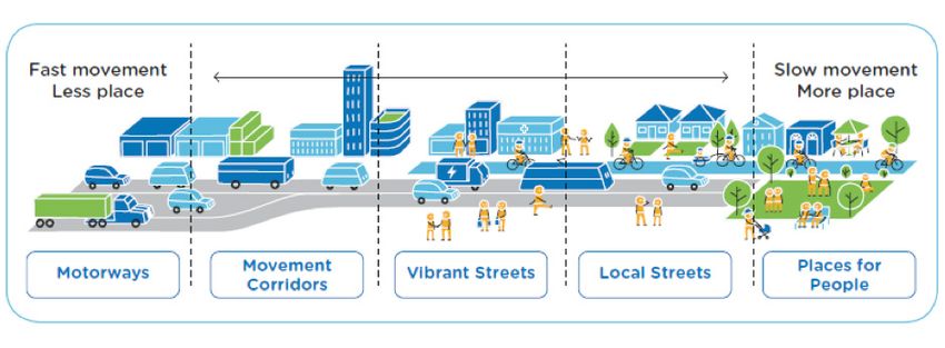
Guidelines for Public Transport Capable Infrastructure in Greenfield Sites – July 2018 Page 19Appendix 2 – Movement and Place Framework The following is an extract from Future Transport Strategy 2056. Successful Places The liveability, amenity and economic success of communities and places are enhanced by transport. Activating centres with a new Movement and Place framework Successful places include attractive spaces where people can meet and enjoy their leisure time, such as town squares, libraries and community centres, parks, sportsgrounds and waterways. Being able to access these spaces easily by active or public transport encourages people to be more physically active and increases social interactions in communities. Centres, both in metropolitan and regional areas, are the places where the majority of jobs and services are located as well as attractions like shops, restaurants and parks. Roads through and around these centres serve an important movement purpose, allowing people travel to and from the centre and move easily within it. They also serve a place function by operating in a way hat allows attractive places for people and strong local economies to develop and thrive. The Movement and Place framework provides a tool to manage the road network in a way that supports safe, efficient and reliable journeys for people and freight while enhancing the liveability and amenity of places. The Framework will guide specific corridor and place plans to be developed as supporting plans of Future Transport 2056. A Movement and Place Practitioners Toolkit will be made available to provide guidance to stakeholders involved in planning, designing and operating the road network. Figure A2: Movement and place Source: Future Transport Strategy 2056 Guidelines for Public Transport Capable Infrastructure in Greenfield Sites – July 2018 Page 20
Appendix 3 – Policy Context
The following policies and guidelines need to be considered in developing public transport capable
infrastructure in greenfield sites.

 Policies and Guidelines Applicable to Greenfield Sites

 Document                            Description

 NSW State Priorities                There are 18 state priorities being actioned by the NSW Government.
                                     Building infrastructure – Improving road travel reliability is one of
                                     these priorities.

 Integrated Public Transport         Provide guidance for service planning activities in the Sydney
 Service Planning Guidelines         Metropolitan area to support the implementation of state government
 Sydney Metropolitan Area            policy. The guidelines align with the actions of the NSW Long Term
                                     Transport Master Plan and individual modal delivery plans for bus,
                                     ferry, light rail and train.

                                     The Guidelines were published December 2013 and support
                                     improvements to services in the area over the short to medium term
                                     (up to ten years).

                                     Of particular note are the Service Coverage Guidelines that support
                                     the development of a connected and integrated public transport
                                     network that facilitates travel opportunities to meet the needs of
                                     different customer groups.

 Integrated Public Transport         Provide guidance for service planning activities in the Outer
 Service Planning Guidelines         Metropolitan area to support the implementation of state government
 Outer Metropolitan Area             policy. The guidelines align with the actions of the NSW Long Term
                                     Transport Master Plan, individual modal delivery plans for bus, ferry,
                                     light rail and train and Regional Transport Plans.

                                     The Guidelines were published June 2016 and support improvements
                                     to services in the area over the short to medium term (up to ten years).

                                     Of particular note are the Service Coverage Guidelines that support
                                     the development of a connected and integrated public transport
                                     network that facilitates travel opportunities to meet the needs of
                                     different customer groups.

 Public Transport Service            Provide guidance for service planning activities in Rural and Regional
 Planning Guidelines Rural and       NSW to support the implementation of state government policy.
 Regional NSW                        The guidelines align with the actions of the NSW Long Term Transport
                                     Master Plan and individual modal delivery plans for bus, government
                                     funded coach and train and Regional Transport Plans.

                                     The Guidelines were published October 2015 and support
                                     improvements to services in the area over the short to medium term
                                     (up to ten years).

                                     Of particular note are the Service Coverage Guidelines that support
                                     the development of a connected and integrated public transport
                                     network that facilitates travel opportunities to meet the needs
                                     of different customer groups and the Rural and Regional Service
                                     Planning Process.

Guidelines for Public Transport Capable Infrastructure in Greenfield Sites – July 2018                Page 21
Policies and Guidelines Applicable to Greenfield Sites
Future Transport Strategy The strategy, released March 2018, is the refresh of the Long Term
2056 Transport Master Plan. Future Transport will be a suite of policies,
strategies and guidelines which will provide an innovative and
contemporary guide for the NSW Government’s transport response
to change over the next 40 years.
TfNSW Disability Action Plan Plans to ensure that the needs of the customer, including those with
2012 – 2017 / TfNSW Disability a disability or limited mobility, are placed at the centre of planning
Inclusion Action Plan 20017 – and decision-making for the transport system.
2021 Consultation Draft
NSW Road Safety Strategy The NSW Road Safety Strategy 2012 – 2021 establishes the direction
2012 – 2021 of road safety in NSW for the next ten years. The strategy sets out the
safe system approach with the end goal of no death or serious injury
occurring on the road transport network.
Local council guidelines Greenfield sites should comply with relevant local council guidelines.
Guidelines for Public Transport Capable Infrastructure in Greenfield Sites – July 2018 Page 22Appendix 4 – Service Coverage Guidelines
Sydney Metropolitan Area
Integrated Public Transport Service Planning – Service Coverage Guidelines
Weekday 90% of households to be within 400 metres (as the crow flies) of a bus stop,
ferry wharf, light rail station or train station between the hours of 06:00 – 22:00.
Saturday 90% of households to be within 400 metres (as the crow flies) of a bus stop,
ferry wharf, light rail station or train station between the hours of 09:00 – 18:00.
Sunday and 90% of households to be within 800 metres (as the crow flies) of a bus stop,
Public Holiday ferry wharf, light rail station or train station between the hours of 09:00 – 18:00.
Source: Integrated Public Transport Service Planning Guidelines Sydney Metropolitan Area
Outer Metropolitan Area
Integrated Public Transport Service Planning – Service Coverage Guidelines for Regional Cities
and Urban Areas
Regional Cities Urban Areas
Weekday 90% of households to be within 400 85% of households to be within 800 metres
metres (as the crow flies) of a bus stop, (as the crow flies) of a bus stop, ferry wharf,
ferry wharf, light rail station or train station light rail station or train station between the
between the hours of 06:00 – 22:00. hours of 06:00 – 22:00.
Saturday 90% of households to be within 400 85% of households to be within 800 metres
metres (as the crow flies) of a bus stop, (as the crow flies) of a bus stop, ferry wharf,
ferry wharf, light rail station or train station light rail station or train station between the
between the hours of 08:00 – 18:00. hours of 08:00 – 18:00.
Sunday 90% of households to be within 800 85% of households to be within 800 metres
and Public metres (as the crow flies) of a bus stop, (as the crow flies) of a bus stop, ferry wharf,
Holiday ferry wharf, light rail station or train station light rail station or train station between the
between the hours of 09:00 – 18:00 hours of 09:00 – 18:00.
Source: Integrated Public Transport Service Planning Guidelines Outer Metropolitan Area
Rural and Regional NSW
Public Transport Service Planning – Service Coverage Guidelines
Inter-regional Needs assessment to determine service coverage to Sydney and major regional centres,
based on customer travel profiles, infrastructure capacity and resources availability.
Intra-regional Needs assessment to determine service coverage between major centres and towns,
based on regional and district travel profiles.
Travel Travel within major regional centres:
in major • 85% of households to be within 800 metres (as the crow flies) of a bus stop, train
regional station or coach stop:
centres and
• Weekday: 07:00 – 18:00
towns
• Saturday: 08:00 – 18:00
• Sunday and Public Holidays: 09:00 – 18:00.
Travel within major towns and towns:
• needs assessment to determine service coverage, based on local demand and
resource availability.
Travel between villages, towns, major towns and/or major regional centres:
• needs assessment to determine service coverage, based on local demand and
resource availability.
Source: Public Transport Service Planning Guidelines Rural and Regional NSW
Guidelines for Public Transport Capable Infrastructure in Greenfield Sites – July 2018 Page 23Appendix 5 – Green Travel Plans A green travel plan should be produced for the greenfield site, considering the following: • how to minimise the environmental impact of operations and ensure environmental integrity • contribute to human health and well-being and encourage more active transport • aim to reduce greenhouse gas emissions, reduce congestion and improve travel times and productivity Possible actions for a green travel plan may include: Walking • produce a map showing safe walking routes to and from your site with times, not distances, to local facilities, such as shops and public transport stops • open-up short cuts for pedestrian access across/along the proposed work site • ensure pedestrian safety and access is not compromised during construction Cycling • provide a sufficient number of secure bicycle parking spaces to meet peak needs, which are easily accessible, well-lit and secure • ensure bike parking is clearly visible or provide signage to direct people to bike parking spaces • review condition and interconnection opportunities of existing onsite cycle routes / upgrade or provide new onsite cycle routes • ensure cycle routes are not compromised during construction • provide new cycle routes and consider the interconnection opportunities with existing cycle route Guidelines for Public Transport Capable Infrastructure in Greenfield Sites – July 2018 Page 24
Appendix 6 – Bus Fleet Specifications
The majority of the bus fleet operating in the Sydney metropolitan and outer metropolitan areas consist of
the following. The information provided below is correct at the time of publication.

A6.1 Bus length and door position

         Type of Bus               Length                No. of                            Bus Door Locations
                                  (meters)               Doors                         (meters from the front of bus)

                                                                                  Door 1          Door 2            Door 3

         Standard rigid               12.5                    2                   0-2 m            6-8 m

         Double decker                12.5                    2                   0-2 m          4.5 – 6m

         Long rigid                   14.5                    2                   0-2 m            7-9 m

         2-door
                                      18                      2                   0-2 m           11-13 m
         Articulated

         3-door
                                      18                      3                   0-2 m            4-6 m            11-13 m
         articulated

        Standard bus
        12.5m
                                                                                                                  Door Position
        Double decker
        12.5m

        Long rigid bus
        14.5m

        Articulated bus
        18m
        3 door
        articulated bus
        18m
                          0   1   2    3     4   5   6    7       8   9   10 11    12 13 14 15 16 17 18
                                                              Length (m)

A6.2 Bus width and height
                                                           4.3m

             2.5m
                                      Double decker
          Bus width:                   bus height:
            2.5m                           4.3m

Guidelines for Public Transport Capable Infrastructure in Greenfield Sites – July 2018                                  Page 25
You can also read