Habitat and flow requirements of freshwater mussels in the northern Murray-Darling Basin.
←
→
Page content transcription
If your browser does not render page correctly, please read the page content below
Habitat and flow requirements of freshwater
  mussels in the northern Murray-Darling Basin.

             Wolkara, Darling River (Barka), between Brewarrina and Bourke, 25 July 2020
                       Refugial waterhole where freshwater mussels persisted.

                  Report to the Commonwealth Environmental Water Office

                                            November 2020

                                 Fran Sheldona and Nicole McCaskerb
Co-authors: Michelle Hobbsa, Paul Humphriesb, Hugh Jones, Michael Klunzingera and Mark Kennarda

                             a
                               Australian Rivers Institute, Griffith University
                  b
                      Institute of Land, Water and Society, Charles Sturt University

                                              Page 1 of 59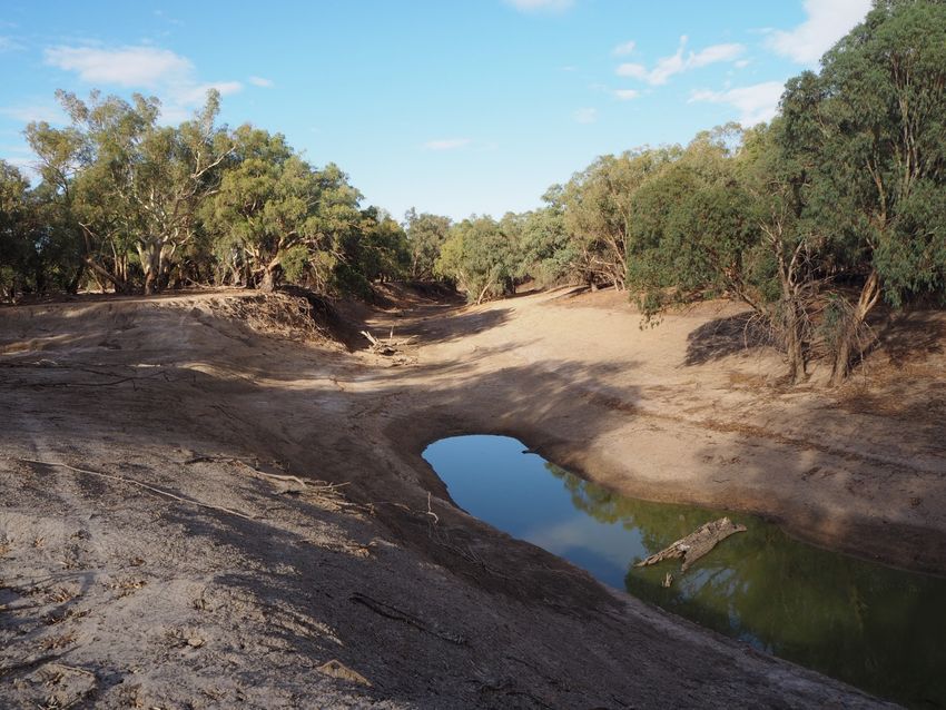
Acknowledgement

The authors respectfully acknowledge the Traditional Owners of the lands and waters of the
Murray-Darling Basin, particularly those whose lands we walked on in this study, across the
Darling, Barwon, Macquarie, Namoi, Gwydir and MacIntyre rivers. We acknowledge that
Aboriginal peoples have cared for the rivers for millennia, and pay our respects to the Elders, past
and present.

We also thank all other landowners for access to the river for sampling and the Commonwealth
Environmental Water Holder for showing an interest in freshwater mussels. Further appreciation
goes to Deanna Duffy, Spatial Analysis Unit at Charles Sturt University, for mapping support. We
hope this survey of freshwater mussels across the northern part of Australia’s largest river basin
would have made the late Keith F. Walker smile, although we are sure he would have been
saddened to see the extent of the mortality of his favourite river mussel.

                      Sampling mussels, Macquarie River, Mumble Peg, 8 Mar 2020

                                            Page 2 of 59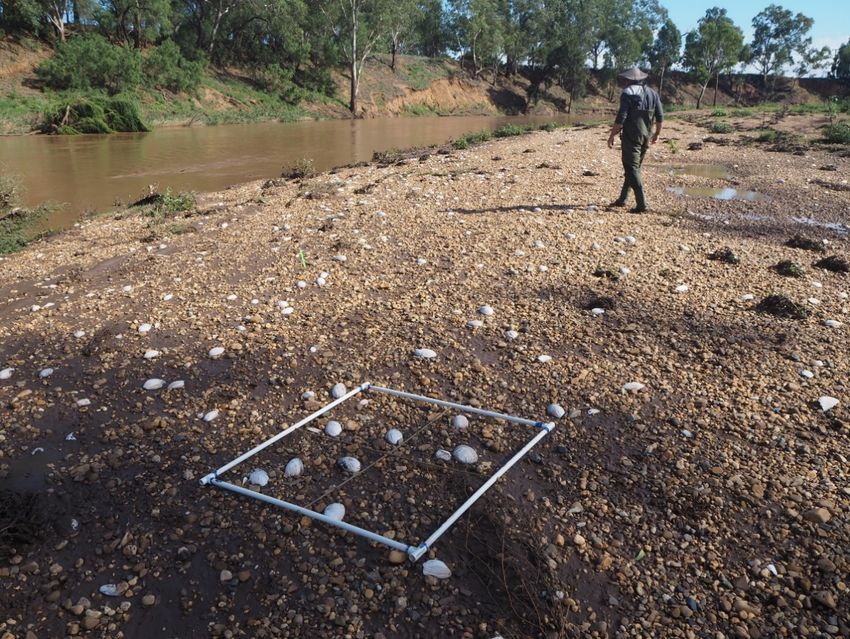
Executive Summary
Freshwater mussels are considered ecosystem engineers of rivers; they modify substrates through
burrowing, mediate water quality through filtration, provide food and habitat for other organisms
and play a significant role in the biogeochemical cycling of nutrients and are also seriously
threatened globally. The rivers of the northern Murray-Darling Basin (MDB) are home to three
species of freshwater mussel – the large ‘river mussels’ Alathyria jacksoni and Alathyria condola and
the smaller ‘floodplain/billabong mussel’ Velesunio ambiguus. As sedentary, long-lived organisms,
obtaining an understanding of the habitat requirements of resident freshwater mussels will provide
insights into the natural hydrology of Australia’s inland rivers, and the potential role healthy
populations of freshwater mussels could play in influencing water quality through biofiltration. This
project was conceived in response to the extensive drought in the northern Murray-Darling Basin
between 2017 and early 2020 and the reports of extensive mussel mortality. The specific aims were
to review existing knowledge and identify knowledge gaps in relation to environmental water
requirements, life history, physiological tolerances and habitat requirements and cultural
significance of freshwater mussels in the Murray-Darling Basin, improve baseline understanding of
distribution and structure of freshwater mussels in the Northern Basin and make recommendations
for land and water management to protect freshwater mussel populations. This was achieved
through a predictive analysis of mussel distribution, and analysis of the hydrological conditions
during the drying event and a field survey to establish the extent of mussel mortality at sites across
the northern Murray-Darling Basin.
A boosted regression tree model (BRT model) was developed to predict the likely distrbution of A.
jacksoni, and the broad environmental drivers explaining this distribution. The model predicted that
A. jacksoni was likely to occur broadly across the mid to lowland reaches of the Barwon-Darling River
and its associated north-eastern and eastern tributaries, absent from westerly the Warrego and
Paroo Rivers. The most influential environmental variables on the prediected distribution of A.
jacksoni the were upstream catchment area, average catchment slope and average saturated
hydraulic conductivity; these variables all relate to runoff and water availability, suggesting A.
jacksoni tends to occur in streams with catchments above a certain size. The model also identified
that annual average primary production, average stream elevation, catchment relief and stream
forest cover had some influence on distribution.
Our hydrological analysis suggested that at nearly all gauges analysed the duration of cease to flow
(CTF) events in the hydrological drought of 2018-2020 was longer, and sometimes more than double
the duration, of the maximum CTF length for the preceeding 37 years, with the lower gauges on the
tributary rivers and the gauges on the Barwon-Darling having the greatest difference. This increase
in drying duration likely had a significant impact on mussel populations.
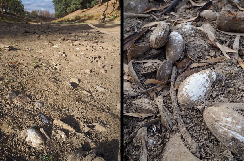
Of the 90 sampled sites, 53 contained evidence of freshwater mussels with three species dectected,
Velesunio ambiguus (17 sites), Alathyria jacksoni (45 sites) and Alathyria condola (3 sites). There
was evidence of A. jacksoni in reasonable abundance in all rivers except the Gwydir and Macintyre.
In these two systems evidence of V. ambiguus was more obvious (Appendix 7.3). Despite the
evidence of A. jacksoni throughout most tributaries most records were of deceased mussels and at
no site were only live mussels observed. The greatest abundance of A. jacksoni, both alive and dead,
was observed in the lower Darling below Menindee. At some sites thousands of dead mussels were
surveyed with site mortality estimates of between 20-100% across the nothern Basin.
Page 3 of 59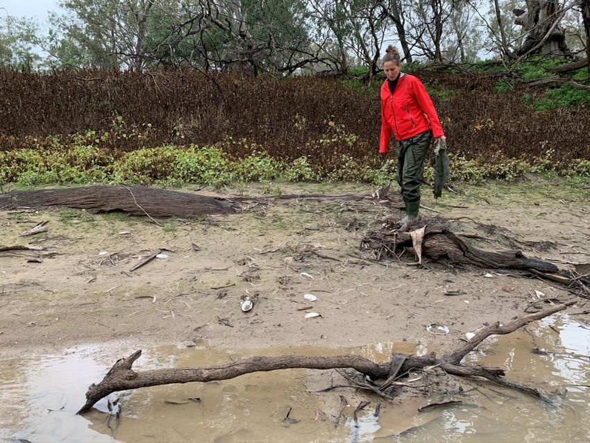
The combination of rapid and quantitative surveys used in this study suggest that the loss of mussel
populations across the northern Murray-Darling Basin resulting from the drying conditions of 2017-
2019 is significant and widespread. This is a cause for concern given the longevity of mussel
individuals and the poor evidence of widespread recent recruitment. Based on our analyses we
make the following five (5) broad recommendations:

Recommendation 1: that further research needs to be undertaken to understand the biology of
freshwater mussels in the northern Murray-Darling Basin, including their reproduction, recruitment,
growth patterns and diets, as well as their role in the ecosystem of the northern Murray-Darling
Basin Rivers – not least because, besides fish, they were historically the dominant animal by weight
in these rivers.

Recommendation 2: that a focus be made on monitoring freshwater mussel recovery in both the
short- and long-term. This should include an understanding of which fish species act as hosts and
what conditions are required for successful recruitment and establishment of juveniles.

Recommendation 3: that the importance of low flows and refugial habitats, reaches and waterholes,
be formally recognised for freshwater mussels in the northern Murray-Darling Basin and the flow
requirements of freshwater mussels be incorporated into flow management plans.

Recommendation 4: that the role of refugial reaches and waterholes in the landscape persistence of
mussels and fish be recognised and the flow required to maintain the integrity of these physical
places in the channel network be understood and incorporated into flow management plans. This
would require a basin- wide perspective of the Water Sharing Plans and Water Resource Plans to
ensure the critical area of the Barwon-Darling River has adequate flows for long-term population
survival.

Recommendation 5: that a specific Freshwater Mussel Recovery Plan be developed in consultation
with the communities of the northern Murray-Darling Basin and this plan articulate with Fish
Recovery Plans.

                                            Page 4 of 59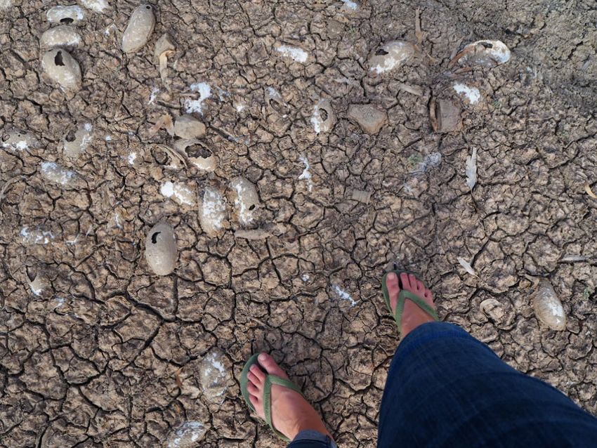
Contents
1      Introduction .................................................................................................................................... 6
    1.1        Freshwater mussels of the northern Murray-Darling Basin ................................................... 6
    1.2        What do we know about habitat requirements? ................................................................... 8
    1.3        What do we know about their biology? ................................................................................. 9
    1.4        What do we know about their cultural significance? ........................................................... 11
    1.5        Project Significance and Aims ............................................................................................... 12
2      Methods ........................................................................................................................................ 13
    2.1        Predictive model methods .................................................................................................... 13
    2.2        Hydrological analysis ............................................................................................................. 17
    2.3        Mussel survey methods ........................................................................................................ 20
       2.3.1          Site selection ................................................................................................................. 20
       2.3.2          Site description ............................................................................................................. 21
       2.3.3          Mussel surveys .............................................................................................................. 21
    2.4        Population and mortality estimates ..................................................................................... 24
    2.5        Size frequency ....................................................................................................................... 24
3      Results ........................................................................................................................................... 25
    3.1        Predictive model of mussel distribution in the northern Murray-Darling Basin .................. 25
    3.2        Hydrological setting of the northern Basin ........................................................................... 29
    3.3        Presence – absence of mussels across the northern Murray-Darling Basin 2020 ................ 33
    3.4        Estimates of mussel mortality, Summer 2020 ...................................................................... 36
    3.5        Size frequency ....................................................................................................................... 42
4      Discussion...................................................................................................................................... 44
5      Recommendations ........................................................................................................................ 46
6      References .................................................................................................................................... 48
7      Appendices .................................................................................................................................... 53
    7.1    Appendix 1: Bibliography of journal publications for the Australian Hyriidae found in the
    northern Murray-Darling Basin ......................................................................................................... 53
    7.2        Appendix 2: Details of sites sampled and mussel abundance .............................................. 55
    7.3    Appendix 3: Raw count data from mussel surveys across 90 sites in the northern Murray-
    Darling Basin. .................................................................................................................................... 57

                                                                    Page 5 of 59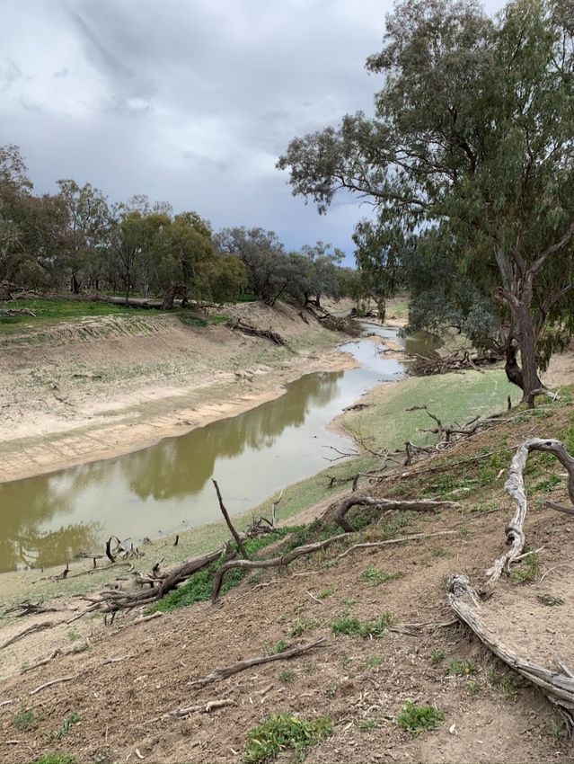
1 Introduction

1.1 Freshwater mussels of the northern Murray-Darling Basin
Freshwater mussels are considered ecosystem engineers of rivers; they modify substrates through
burrowing, mediate water quality through filtration, provide food and habitat for other organisms
and play a significant role in the biogeochemical cycling of nutrients (Vaughn et al. 2008, Vaughn
2018). Many freshwater mussel species are also seriously threatened globally (Lopes-Lima et al.
2018) and Australia is no exception (Walker et al. 2014). Their decline is driven by habitat
modification, altered flow regimes, water quality degradation, climate change, introduction of non-
native species, declines in host fishes (i.e. those which support the parasitic mussel larval stages) and
over-exploitation (Ferreira-Rodríguez et al. 2019). Compared to other areas of the world, however,
our understanding of Australian freshwater mussel (Mollusca: Bivalvia: Unionida) ecology is limited.
There is limited published information on historic diversity or abundance of freshwater mussels
(Walker et al. 2014), making quantifiable declines and resulting changes in ecosystem function
difficult to ascertain.

The rivers of the northern Murray-Darling Basin (MDB) are home to three species of freshwater
mussel – the large ‘river mussels’ Alathyria jacksoni and Alathyria condola and the smaller
‘floodplain/billabong mussel’ Velesunio ambiguus (Walker et al. 2014). The large river mussel,
A. jacksoni, was an abundant component of the benthic fauna of the Barwon-Darling River (see
Jones 2007) where it likely played a key role in riverine food webs, through its feeding behaviour
resulting in biofiltration as well as being an important component of aquatic and terrestrial
vertebrate diets (Fisher 1973; Vestjens 1973; Woollard et al. 1978; van Tets 1994; DPIPWE 2009;
Shannon & Mendyk 2009). Taxonomic reviews suggest A. jacksoni and A. condola are endemic to the
Murray-Darling Basin, not occurring in any other catchments, while V. ambiguus has a wide
distribution across eastern Australia (Walker 1981). Records in the South Australian Museum
(reference) of A. jacksoni from around Innamincka on Cooper Creek in the Lake Eyre Basin, and one a
site in the Dawson catchment (QLD) are likely poor identifications. The Cooper Creek mussels may
be one of the species of Velesunio identified from the Lake Eyre Basin (Balker et al. 2003; 2004) and
the mussels from the Dawson catchment are likely Alathyria pertexta.

Accounts of the abundance and ubiquity of river mussels throughout the Murray-Darling Basin were
common in the diaries and journals of inland explorers like Oxley, Hume and Hovell, Mitchell, Sturt
and Hawdon and the reminiscences of early settlers. Near present-day Albury in 1824, William
Hovell noted that “the lagoons are literally crowded with wild ducks, and in the muddy bottom near
the banks, is plenty of muscles (sic)” (Andrews, 1981).These early colonial chroniclers also noted the
importance of river mussels as food for the Aboriginal people they encountered, the use of mussel
shells as fish hooks and as cutting implements, as well as the widespread presence of shell middens
on the banks of the rivers along which they travelled. Indeed, mussels were considered so abundant
even into early 20th Century, that New South Wales fisheries scientist David Stead thought that they
could be a commercial industry, commenting “mussels, too, exist in great quantity, and it is thought
that they will find favour with the public as a canned product.” (Fishery Report, NSW Parliamentary
Papers, 1910). Furthermore, descriptions of the diet of Murray cod by colonial natural historians at
the time emphasized the significance of river mussels in the diet of Murray cod (Bennett, 1834). And
this was taken up by commercial fishermen in South Australia, Victoria and New South Wales, who
routinely used them as bait on their set lines (Wallace-Carter, 1987).

                                              Page 6 of 59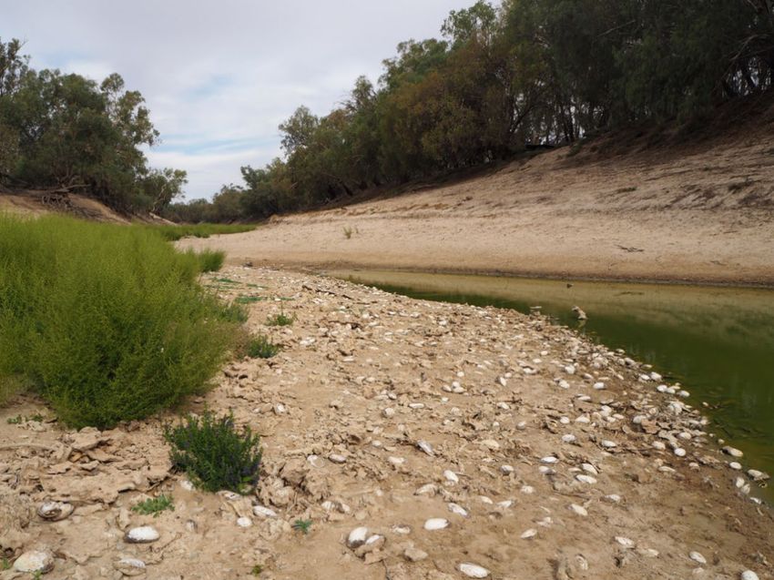
A literature search using the Scopus database identified 27 unique publications relating specifically
to the species of freshwater mussel found in the northern Murray-Darling Basin (Appendix 7.1). Of
these a majority of the publications were related to the more commonly distributed Velesunio
ambiguus, the quite rare Alathyria condola was the subject of only three publications and there
were three publications dealing with the general biogeography of Australian Hyriidae (Figure 1-1a).
In terms of research areas, the majority (36%) of publications related to the broad theme of
“ecology” with most of these also related to V. ambiguus while 26% of the publications focused on
“ecotoxicology”, mostly metals accumulation (Figure 1-1b).

                  V. ambiguus   A. jacksoni                          Physiology/Anatomy     Genetics
                  A. condola    General                              Biogeography           Ecotoxicology
                                                                     Ecology                Cultural

                      9%
                                                                                     4%
                                                                                                  15%
             9%

                                                                                                            7%
                                                                   37%

       23%                                    59%                                                           11%

                                                                                            26%

                                                        (a)                                                          (b)
Figure 1-1. Pie-diagrams showing the proportion of manuscripts from the Scopus search related to (a) each species within
the northern Murray-Darling Basin and (b) research areas.

Despite a dearth of research on the freshwater mussels of the northern Murray-Darling Basin, and
the recognised importance of freshwater mussels in riverine ecology (Ferreira-Rodríguez et al. 2019),
there is evidence to suggest the populations in the northern Murray-Darling Basin are threatened;
however, the threats are not entirely clear. A recent discussion paper prepared for the NSW Natural
Resources Commission’s report on the Barwon-Darling Water Sharing Plan (NSW NRC, 2019)
reported "Site visits (across the Barwon-Darling River) conducted in 2019 indicated large numbers of
dead river mussels varying in number from a few to thousands, with live mussels only found in one
location near Tilpa. These surveys appeared to encompass most of the river mussel population of the
Barwon-Darling, representing a far greater impact on riverine biota than the fish kills that triggered
two independent reports. The decline in river mussels is indicative of a broader, longer-term decline
in river health that affects endangered species including Murray Cod and Silver Perch." (see p 5 NRC

                                                     Page 7 of 59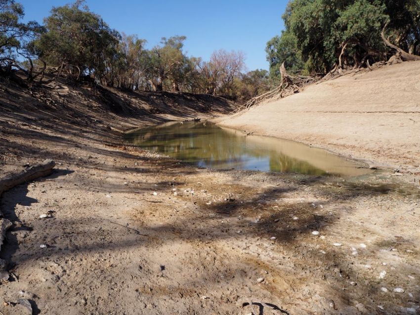
BD WSP Draft 2019). Current responses to drought and the mass fish deaths (see Vertessy et al.
2019; Academy of Science, 2019) have focused on protecting either specific fish species (e.g. Murray
Cod) or more broadly, fish populations (e.g. those around Menindee Lakes) and have occurred
largely from within a fish management framework; preserving genetic and breeding stock for when
the drought ends. These responses, while vitally important, exclude other important and
conspicuous aquatic species like freshwater mussels, which no doubt play a vital role in ecosystem
functioning in our inland rivers. The following literature review focusses on what is known about the
ecology of the freshwater mussels of the northern Murray-Darling Basin.

1.2 What do we know about habitat requirements?
Freshwater mussels are sedentary and long-lived (Walker 1981; Klunzinger et al. 2014; Herath et al.
2019), so their ecology is intrinsically linked to their aquatic habitat with the nature of the
immediate flowing water environment shaping their growth, survival and reproduction (Humphrey
& Simpson 1985; Balla & Walker 1991; Allan et al. 2013; Sheldon 2017). For many rivers and
streams, the disappearance of freshwater mussels reflects ecosystem degradation (Brainwood et al.
2006; Brainwood et al. 2008; Allen et al. 2013; Randklev et al. 2018), reminiscent of the proverbial
‘canary in the coal mine’ scenario.

Specific details of habitat requirements of the freshwater mussels of the northern Murray-Darling
basin are not known. However, the common names of the two dominant species, the river mussel
Alathyria jacksoni and the floodplain mussel Velesunio ambiguus, are indicative of the broad habitats
that they occupy (Walker 2017), while Alathyria condola has a geographically restricted distribution
and is likely only found in river channels with relatively strong flow conditions (Walker 1981). The
river mussels (Alathyria spp.) are restricted to the permanent channels of rivers where they require
well-oxygenated conditions (Sheldon & Walker 1989), preferably in flowing water, whereas the
floodplain mussel occupies a wide range of habitats including temporary flowing creeks, backwaters
and billabongs and artificial environments such as farm dams and irrigation channels (Jones 2011).
The floodplain mussel is uncommon in major river channels where it is exposed to strong water
currents, but it is well adapted to drought conditions and can burrow into the mud where it may
aestivate for some years (Walker 1981). Using these broad habitat distinctions as a guide Alathyria
jacksoni is likely restricted to the main channels of the Barwon-Darling and its associated tributaries,
with Velesunio ambiguus likely occurring more frequently in the lower, floodplain wetland regions of
the tributaries and restricted floodplain habitats along the Barwon-Darling mainstem. What is
unknown, however, is the micro-habitat requirements of either species: are they locally restricted to
specific regions of the channel based on substrate or localised flow conditions?

                                             Page 8 of 59
1.3 What do we know about their biology?
The family Hyriidae, of which both A. jacksoni and V. ambiguus are members, are part of the broader
superfamily Unionoidea within the Order Unionoida. These freshwater mussels have specialised life
cycles which involve a parasitic stage (Figure 1-2). Fertilised eggs are moved into specialised
portions of the female’s inner gills, known as marsupia, where they develop into a hooked parasitic
stage called a glochidium (Jones et al. 1986). Mature glochidia are then released into the water
column, usually on strings of mucous, where they await to eventually attach to a vertebrate host,
mostly fish (Walker 1981). Once a suitable host is attained the glochidium anchors itself by closing its
teeth shut around a pinch of its host’s skin; after which it becomes encysted by its host’s epidermis
and begins its approximate three-week metamorphosis into a juvenile mussel (Walker 1981).

Figure 1-2: General scheme of the freshwater mussels’ life cycle. From Modesto et al. (2018).

                                                      Page 9 of 59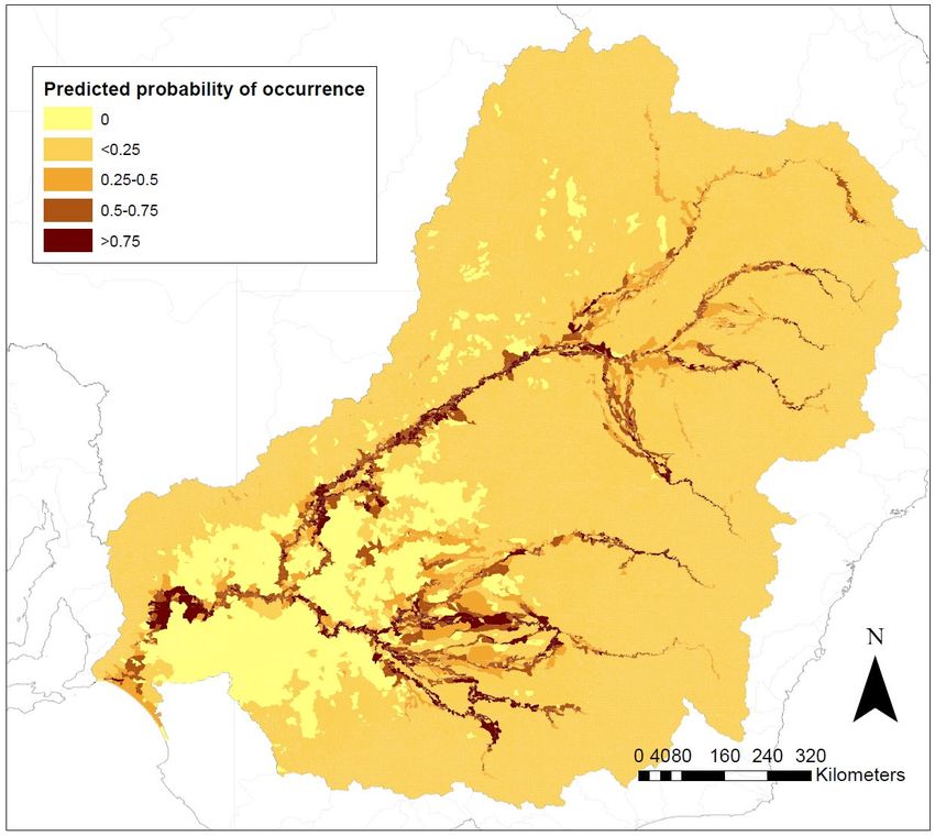
Information on specific aspects of life histories of Australian freshwater mussels is limited to a
handful of studies conducted over the last 40-50 years, mostly from outside of the MDB (Atkins
1979; Humphrey & Simpson 1985; Jones et al. 1986; Jupiter & Byrne 1997; Widarto 1993; Byrne
1998; Jones 2014; Klunzinger et al. 2012, 2013, 2014; Klunzinger 2020), although host fishes,
glochidia morphology and reproductive phenology were elucidated for river and lake populations of
V. ambiguus and A. jacksoni from the River Murray by Walker (1981, 2017). In general, Australian
freshwater mussels appear to be host fish ‘generalists’ with most fish species (including several
introduced species) able to support metamorphosis of glochidia to free-living juvenile mussels;
however, some studies have shown introduced carp (Cyprinus carpio) and goldfish (Carassius
auratus) consistently rejecting Australian glochidia across a wide geographic range in several species
of mussel (Walker 1981; Humphrey & Simpson 1985; Widarto 1993; Klunzinger et al. 2012; Jones
2014). In the Murray-Darling Basin, where common carp now dominate fish communities in many
parts of the river, their predominance could present significant recruitment challenges for
freshwater mussel populations if they are unable to act as host species.

There are also limited Australian studies on freshwater mussel reproductive biology. Walker (2017)
followed the gonadal cycles of both A. jacksoni and V. ambiguus across four years (1982-1986) which
included periods of low flow and moderate flooding in the lower River Murray, South Australia.
Female A. jacksoni produced glochidia seasonally, brooding embryos in the spring and releasing in
the spring and summer. In contrast, female V. ambiguus had glochidia present most of the year with
peak releases in spring and summer. The study was undertaken in the lower Murray, at the end of
the Murray-Darling Basin where temperatures are very seasonal. In the coastal rivers of
southeastern Australia, seasonality in the reproductive cycles of three species of Hydridella and
Cucumerunio novaehollandiae has also been observed (Atkins 1979; Jones et al. 1986; Jones 2014).
The only other long-term reproductive study of unionids in Australia was for V. angasi in the wet-dry
tropics (Humphrey and Simpson, 1985) where spawning was observed year-round with little
seasonality. Based on these studies, it is likely that there would be some seasonal signal in
reproduction of mussels in the northern Murray-Darling Basin where water temperatures show a
seasonal signal, particularly for Alathyria jacksoni.

There is also limited information on the growth of Australian freshwater mussels from
metamorphosis to adult, however, most field surveys have noted very few juveniles and small
mussels in shoals; whether this is the result of poor recruitment or specific growth patterns is
unknown. Some studies of growth in Velesunionine mussels indicate that mussels initially grow
rapidly in the first several years of life followed by a rapid tapering of growth (Walker 1981;
Humphrey & Simpson 1985; Herath et al. 2019) – this suggests they may be “shooters” (initially grow
rapidly and then slow down) with the lack of small mussels in field populations not reflective of poor
recruitment. However, this is yet to be verified. A study of growth in A. jacksoni from several
locations along the River Murray (Walker 1981) showed that growth and age varied widely in
populations over several locations, with adults of over 30 years old evident in some populations. It
should be noted that age determination was from analysis of externally visible annuli which can give
unreliable estimates of growth in older specimens. Sexual maturity in A. jacksoni is attained at
about 4 years age (Walker 2017). The juvenile survival and growth of mussels in the northern
Murray-Darling Basin is unknown and represents a large knowledge gap.

Like much of their biology, information on the role of freshwater mussels in riverine foodwebs in
Australia is limited. Freshwater mussels are filter feeders, with their feeding action shown to
remove seston, bacteria and algae from the water column with varying degrees of clearance rates
(particles removed from a volume of water), positively affecting water quality (Vaughn 2018). An

                                            Page 10 of 59
Honours study of filtration rates in A. jacksoni as measured in the laboratory, suggested the total
mussel population in the lower Ovens River, Victoria, could clear 2.1 ML day-1 and transfer around
10.5 kg of organic material to the sediment (Brouwer 2019). The same study also suggested that
increased suspended sediment in the water column had negative impacts on filtration rates.
Estimates of filtration rates for A. jacksoni (mean size 94 mm) ranged from 0.03-0.39 L mussel-1 h-1
(Brouwer 2019). How these filtration rates compare to those of mussels in the northern Murray-
Darling Basin is unclear, but these results do suggest that large shoals of freshwater mussels in
remnant refugial pools likely play a significant role in mediating water quality and reducing
phytoplankton biomass.
1.4 What do we know about their cultural significance?
Freshwater mussels have a long history of human use in Australia as a food source, in fishing, as
tools and in cultural practices. Aboriginal shell middens in the Murray-Darling are comprised
primarily of mussel shells, with many snail shells and the remains of other aquatic animals
(Mulvaney 1960; Balme & Hope 1990; Garvey 2017). Velesunio ambiguus and Alathyria jacksoni are
both common in the middens, with the oldest in the Darling dating back to around 27,000 years ago
(Balme 1995; Balme & Hope 1990; Mallen-Cooper & Zampatti 2020), and mussel shell tools from the
area date back to up to 50,000 years ago (Weston et al. 2017). They have been an important food
item in the past, a reliable food source when other food was scarce (Mulvaney 1960; Aboriginal
Victoria 2019). There are references to Aboriginal women digging for mussels in the Darling, cooking
mussels on their fires, and using mussels as bait, particularly for cod (Langloh-Parker 1905). It is not
clear if mussels are still consumed in the Murray-Darling basin, as lack of access to river areas and
poorer water quality are likely limiting factors.
Aboriginal peoples also used mussel shells in the past as scraper tools, for trade, and are still used
for art and cultural practices. For example, contemporary Wiradjuri artist Jonathan Jones used
mussel shells in his 2018 work untitled (giran) which featured contemporary hand-made tools,
including bindu-gaany, freshwater mussel scrapers (Jones 2020). Barkandji artist Badger Bates has
also used freshwater mussel shells in his 2018 exhibition Barka, the forgotten river to highlight
concerns over impacts of lack of flows on mussels (Volkofsky & Bates 2018). While the cultural
significance of mussels has received little attention relative to other aquatic organisms such as fish
and turtles, there is evidence of their spiritual significance in complex totemic and kinship systems
(Langloh-Parker 1905), and their continued use indicates they remain important to Aboriginal
peoples of the Murray-Darling. The concept of ‘river health’ for Aboriginal peoples is multi-faceted,
and importantly includes freshwater mussels (DNRME 2019).
Page 11 of 591.5 Project Significance and Aims
As sedentary, long-lived organisms, obtaining an understanding of the habitat requirements of
resident freshwater mussels will provide insights into the natural hydrology of Australia’s inland
rivers, and the potential role healthy populations of freshwater mussels could play in influencing
water quality through biofiltration. Senior Barkandji have indicated their strong support for research
on mussels because there is evidence to suggest mussel abundance in the Barwon-Darling River has
declined dramatically in the last two decades, reflecting impacts from water resource development
and potentially an increase in flow variability associated with climate change. These conditions have
seen a reduction in low and medium flows combined with two serious hydrological droughts, the
Millenium Drought (2001-2009) and the more recent drying event of 2017-19. These events have
likely placed the freshwater mussels in the Barwon-Darling River in a vulnerable position with
impacts on population abundance, this will have significant impacts on river recovery and long-term
ecosystem function, and on Aboriginal traditional owners and other community members.
This project was conceived in response to the extensive drought in the northern Murray-Darling
Basin between late 2017 and early 2020 (referred to in the remainder of this report as 2017-2019)
and the reports of extensive mussel mortality. The specific aims were to:
(i) Review existing knowledge and identify knowledge gaps in relation to environmental
water requirements, life history, physiological tolerances and habitat requirements and
cultural significance of freshwater mussels in the Murray-Darling Basin
(ii) Improve baseline understanding of distribution and structure of freshwater mussels in
the Northern Basin is covered by:
a. generating a predictive model to get provide a better understanding of distribution
and environmental preferences for the endemic mussel of the MDB, Alathyria
jacksoni;
b. conducting a broad-scale survey across Barwon-Darling and its major northern
tributaries (Macintyre, Gwydir, Namoi and Macquarie rivers) to establish current
distributions of the three known species A.jacksoni, A. condola and V. ambiguus
within main channel habitats, and
c. assessing the impact of the drying event of 2017-2019 on these populations.
(iii) Make recommendations for land and water management
Page 12 of 592 Methods
2.1 Predictive model methods
Predictive models can assist in explaining the factors that are driving the distribution of a species.
Freshwater mussel populations appear to be declining in the Murray-Darling Basin, yet there is
significant uncertainty around their specific threats and needs. By building a model using all known
occurrences for mussel species and linking their presence to environmental data, we can identify the
most important environmental factors associated with known mussel distribution, and predict the
likelihood of them occurring in a given area based on its environmental attributes. From this we can
make deductions about what threatening processes may influence their populations on a landscape-
scale.
Boosted regression trees (BRT) are a robust method of modelling species distribution; the method
has been used to model aquatic species distributions in Australia (Elith et al. 2008; Rose et al. 2016)
and internationally (Cerasoli et al. 2017; Murray-Stoker and Murray-Stoker 2020). It combines two
types of algorithms: regression trees and boosting. Regression links a response to a predictor
variable, but tends to be oversimplistic for complex ecological data. Boosting is a method of
combining many simple models (regressions) in a step-wise fashion to give more accurate
predictions for ecological data, which overcomes the limitations of regression alone (Elith et al.
2008).
The focus species of the distribution model was A. jacksoni, given its endemic status in the Murray-
Darling Basin and the significant reduction in abundances as a result of the recent drought. Though
the focus of this project is the northern Murray-Darling Basin, data from the entire Murray-Darling
Basin has been included to ensure model robustness and make the best use of the limited number of
available data.
Data Collation
Data were sourced from online museum databases, Atlas of Living Australia (ALA 2020), which
includes Online Zoological Collections of Australian Museums (OZCAM), and from MUSSELp (Graf &
Cummings 2020). Unpublished data were also contributed by Dr Hugh Jones (NSW Department of
Planning, Industry and Environment), Associate Professor Paul Humphries and Dr Nicole McCasker
(Charles Sturt University) and Dr Michael Klunzinger (Griffith University). Museum data were
checked to confirm species identification where photographs were provided. All data were checked
to ensure coordinates and geographical locations given were located on or adjacent to waterways.
The presence data spans from the late 1800s through to 2020, though sampling effort has been
much higher since the 1950s and spiked between 2000-2009 (Figure 2-1). Presence data had good
geographical coverage of the Basin, though some northern tributaries, e.g. the Condamine, and
much of the southern basin have not been sampled within the last decade (Figure 2-2). Presence
records for 203 unique ‘sites’ were included for A. jacksoni. As presence-absence data is desirable in
building BRT models, other mussel taxa records were included as ‘pseudo-absences’, including 266
records for V. ambiguus and 18 records for A. condola. These provide suitable proxies for absence
data where true absence data are limited or not available (Elith et al. 2008; Cerasoli et al. 2017).
Each presence record was allocated a reach code using Geofabric, the national stream and nested
catchment framework (Stein et al. 2014). Where there were multiple records in different years in the
same stream reach or segment, the most recent presence record was retained for input into the
model.
Page 13 of 59Figure 2-1: Frequency of mussel records in the Murray Darling basin for A. jacksoni, A. condola and V. ambiguus
Page 14 of 59Figure 2-2: Spatial distribution of A. jacksoni occurrence records in the Murray Darling Basin used for development of
species distribution model (0 = no date for that record).
Environmental predictor variables
A broad range of environmental predictor variables was selected from Geofabric (Stein et al. 2014)
on the basis of those that were likely to be ecologically relevant to mussels. Variables were selected
as those relating to terrain, climate, vegetation, substrate, primary productivity, catchment
connectivity and disturbance (Table 2-1). Selected variables were assessed for correlations to avoid
duplication (Pearson’s r < 0.7).
The model outputs then enabled the prediction of likely spatial occurrence of A. jacksoni across the
basin, based on the predictors (important environmental attributes) identified by the BRT model,
combined with the database of environmental attributes within the stream and nested catchment
framework (Stein et al. 2014).
Page 15 of 59Table 2-1: Environmental attributes used as predictor variables in the BRT model (Stein et al. 2014).
Code Definition Units
Terrain
STRELEMEAN Mean segment elevation m
CATAREA Catchment Area km2
CATRELIEF Catchment relief
RELIEFRATIO Catchment relief ratio
CONFINEMENT Indicator of valley confinement %
DOWNMAXSLP Maximum slope in downstream flow path %
D2OUTLET Distance to outlet km
CATSLOPE Catchment average slope °
CATSTORAGE Catchment storage %
STRAHLER Strahler stream order
Climate
STRANNRAD Stream and environs annual mean solar radiation MJ/m2/day
STRANNTEMP Stream and environs annual mean temperature °C
STRANNRAIN Stream and environs average annual mean rainfall mm
SUBEROSIVITY Sub-catchment average rainfall erosivity R factor (MJ mm)/(ha hr yr)
Vegetation (extant)
STRSHRUBS Stream and valley percentage extant shrub cover %
STRWOODLANDS Stream and valley percentage extant woodland cover %
STRGRASSES Stream and valley percentage extant grasses cover %
STRFORESTS Stream and valley percentage extant forests cover %
Substrate
CAT-SOLPAWHC Catchment average Solum Plant Available Water Holding mm
Capacity
STR-KSAT Stream and valley average saturated hydraulic conductivity mm/h
STR-CLAYA Stream and valley average percent clay in the soil A horizon %
STR-CLAYB Stream and valley average percent clay in the soil B horizon %
STR-SANDA Stream and valley average percent sand in the soil A horizon %
STR-UNCONSOLDTED Stream and valley percentage unconsolidated rocks %
STR-SILICSED Stream and valley percentage siliciclastic/undifferentiated %
sedimentary rocks
Net Primary Productivity
NPPBASEANN Annual mean Net Primary Productivity (Raupach et al. 2002) tC/ha
Network
STRDENSITY Stream density km/km2
Connectivity
DISTUPDAMW Maximum barrier free flow path length upstream (dam walls,
spillways or large dams) km
D2DAMWALL Unrestricted (no dam walls, spillways or large dams) distance
downstream km
Disturbance
CDI Catchment Disturbance Index (Stein et al. 2002) Dimensionless
FRDI Flow Regime Disturbance Index (Stein et al. 2002) Dimensionless
Page 16 of 59Boosted Regression Tree Model
Using ArcMap 10, the presence-absence locations were intersected with the selected ecologically
relevant predictor variables from Geofabric (Stein et al. 2014). These data were built into a model
using boosted regression tree techniques in the R package ‘dismo’ (Hijmans & Elith 2017). A random
subset of data was used to train the model, and remaining data used to evaluate the model
performance. Model performance was assessed with built-in evaluation statistics generated with the
‘SDMTools’ package in R. A step-wise process of simplifying the model by removing unimportant
variables was done using the ‘gbm.step’ package in R. The most important predictor variables were
then able to be identified in the model outputs.
2.2 Hydrological analysis
To better understand the context of the 2017-2019 drought compared with the background
hydrology of the northern Murray-Darling Basin rivers over the last 40 years, daily river discharge
data were obtained from a number of gauging stations within the MacIntyre, Gwydir, Namoi,
Macquarie and Barwon-Darling Rivers for the maximum period 1 Jan 1980 – 1 June 2020 (Table 2-2)
note the length of data varied between gauges) (Table 2-2). Using the time series of daily discharge,
we calculated several drought-related hydrologic indices for each of the gauging stations using the R
package ‘Hydrostats’ (v.0.2.7 Bond 2019). Specifically, we calculated the timing and duration of all
zero-flow spells for the available period of record between 1980 and 2020, for which we defined
zero-flow as flows less than 5 ML/day. We used independence criteria in these calculations to allow
for up to 20 continuous days of flows >5 ML/day before a zero-flow spell would be considered
independent from a previous spell. To compare the hydrological drought conditions during 2017-
2019 to the prevailing 40 years, we calculated cease-to-flow (CTF) spell statistics for the period 2018-
2020, and then across the 1980-2017 time series. As the onset of the low flow conditions occurred
late in 2017 and finished early 2020 the period of 2018-2020 was used to analyse the hydrological
signal of the drought. CTF statistics calculated included the proportion of time that cease to flow
occurred, mean cease-to-flow duration (days), median cease-to-flow duration (days), and maximum
cease to flow duration (days). The variation in the start date for which discharge data was available
across the gauges was not seen to impact the assessment of the timing and duration of zero flow
spells, therefore, rather than excluding these gauges with incomplete time series, we depict the start
of the time series for each flow gauge.
Page 17 of 59Lower Darling River, DS Menindee, Bono Station, 25 March 2020
Page 18 of 59Table 2-2: Summary of the 28 gauging stations used to obtain daily river discharge data (ML/day) from the northern
Murray-Darling Basin rivers studied for this report. Within each river, gauging stations are ordered upstream to
downstream. Data was obtained from waterNSW on 15 September 2020, https://realtimedata.waternsw.com.au/)
River Gauge Gauge name Latitude, longitude Time series
no. start date
MacIntyre 416068 Tintot -29.4216, 150.9822 1988-03-18
416010 Wallangra -29.2626, 150.8995 1980-01-01
416002 Boggabilla -28.5895, 150.3622 1982-04-23
416047 Terrewah -28.6078, 149.8747 1985-01-19
416048 Kanowna -28.6961, 149.3880 1998-03-18
Gwydir 418026 downstream Copeton dam -29.9123, 150.9076 1980-01-01
418012 Pinegrove -29.8938, 150.6283 1980-01-01
418013 Gravesend road bridge -29.5819, 150.3666 1980-01-01
418042 downstream Tareelaroi weir -29.4472, 150.0336 1980-01-01
418053 Brageen crossing -29.3973, 149.5465 1982-10-23
Namoi 419007 Downstream Keepit dam -30.8912, 150.4961 1980-01-01
419001 Gunnedah -30.9720, 150.2556 1980-01-01
419012 Boggabri -28.5895, 150.3622 1980-01-01
419021 Bugilbone (Riverview) -30.2735, 148.8208 1980-01-01
419091 upstream Walgett -30.0278, 148.1537 1998-08-02
Macquarie 421040 Downstream Burrendong dam -32.6332, 149.0811 1980-01-01
421031 Gin Gin -31.9082, 148.0910 1980-01-02
421004 Warren weir -31.7350, 147.8668 1980-01-01
421022 Oxley station -31.1175, 147.5693 1980-01-01
421135 Miltara -30.5602, 147.5970 1989-11-03
Barwon 422003 Collarenebri main channel -29.5471, 148.5761 1980-11-01
422001 Dangar bridge (Walgett) -30.0153, 148.0607 1980-01-01
422002 Brewarrina -29.9472, 146.8637 1980-01-01
Darling 425003 Bourke Town -30.0879, 145.9367 1980-01-01
425004 Louth -30.5347, 145.1150 1980-01-01
425900 Tilpa -30.9344, 144.4188 1995-05-11
Lower Darling 425012 Menindee u/s weir 32 -32.4353, 142.3799 1980-01-01
425005 Pooncarie -33.3864, 142.5678 1980-01-01
Page 19 of 592.3 Mussel survey methods
2.3.1 Site selection
One hundred and fifty (150) random sites were initially identified across the northern MDB as
potential locations for surveys of mussel populations. The position of these randomly selected sites
was used to guide the selection of sampling sites, of which the Macinytre, Gwydir, Namoi,
Macquarie and Barwon-Darling Rivers were targeted (Figure 2-3). Of the 150 sites identified as
potential survey locations, 90 were visited between February – July 2020. Sites were limited to
those that were downstream of the major tributary storages, and upstream of the influence of the
Murray on the Darling River (i.e. upstream of Pooncarie). Each sample ‘site’ consisted of a 500 m
reach.
Figure 2-3: Random survey points to be targeted for surveys of freshwater mussels in the northern Murray-Darling Basin.
Page 20 of 592.3.2 Site description
At each site a description of the reach was compiled. This included recording the Site ID, date and
time of sampling, and the GPS location of the upstream and downstream ends of the reach. Along
the 500 m reach the following features were noted: natural features (such as rocky outcrops, snags
etc), presence of dead mussels on the dry riverbanks, presence of any dense shoals of mussels and
estimation of the river width at about 3 or 4 places. If water was present an estimate of the
approximate surface area of the pool(s) was made by estimating the width and length. A rough
sketch of the reach with features marked was made.
Qualitative descriptions were also made of several reach features. The extent of riparian vegetation
was assessed using a rank score from 0-5 (0 = no riparian trees at a site, 1-2 = individual trees with
lots of gaps; 3-4 = close trees but not thick; 5 = continuous riparian cover along the reach), the
dominant riparian form was noted (e.g. Eucalypt, willow, acacia). Substrate was also assessed using
percentage across the substrate categories of ‘silt’, ‘sand’, ‘cobble’ and ‘gravel’. The extent of in-
channel woody debris was also assessed using a rank score from 0-5 (0 = no snags in a reach, 1-2 =
sparsely placed snags; 3-4 = moderately dense; 5 = very dense woody debris). The position of mussel
shells was also noted with respect to the position of channel bends and benches.
2.3.3 Mussel surveys
Assessment of mussel populations at the 90 sites took place between February and July 2020. The
timing of surveys coincided with the onset of a La Niña event. This resulted in above average rainfall
and the resumption of flows down the northern Basin tributaries and Barwon-Darling River for the
first time since 2017. Consequently, initial methods for assessing mussel populations on primarily
dry riverbeds had to be adapted to allow for the variety of flowing conditions encountered across
the sampling period. The range of survey methods used could be categorised into five main survey
types (Table 2-3).
Quantitative assessments
At sites that were either characterised by either having a dry river bed (where water refugia may or
may not have still been present), or the presence of a base flow that was wadable throughout,
quantitative methods were used to estimate the number of mussels present within the 500 m reach
for each species, and the proportion that were alive vs dead. Where the survey reach was dry, all
exposed shells throughout the entire 500 m reach were identified and counted. If water holes were
present in these same reaches, mussels were counted where water was wadable, and recorded as
live or dead. The proportion of reach that consisted of water holes also estimated (Table 2-3, survey
type 1a). Species were identified following conchology of McMichael & Hiscock (1958) and taxonomy
of Walker et al. (2014).
Where wadable, base flows or extensive shallow pools were present throughout a survey reach, we
assessed mussel population using transect surveys (Table 2-3, survey type 1b). There were two types
of transect surveys that we were able to deploy. For the first approach, five equally spaced transects
spanning the river were sampled. Two 1 x 1 m quadrats were placed side by side along the transect
line and progressively moved across the channel (continuously) as sampling progressed so that a 2 m
wide belt transect was sampled. This set of 5 transects formed a primary unit in systematic sampling
and each transect was termed a secondary unit. The numbers of mussels were summed for the
secondary units, giving a single total count for each primary unit. Three primary units, each placed at
a random starting point between 0-100 m of the downstream end of the reach were deployed. For
the second approach, this method was simplified and between 10-15 transects (0.5 wide) positioned
Page 21 of 59perpendicular to the riverbank were conducted throughout a 500m reach, with mussels identified,
counted, and recorded as either alive or dead. In total there were 21 sites across the northern
Murray-Darling Basin for which quantitative data was collected.
Rapid assessments
Where flows were present at the survey sites when visited, we used rapid assessment approaches to
characterise the physical attributes of the reach, while walking the exposed part of the river to look
for evidence of mussel shells or shell fragments. While we were not able to quantify the number of
live and dead mussels at these sites, we were still able to collect valuable presence/absence data for
the three target species using this approach. There were three variations in rapid assessments
conducted depending on river height levels. For sites where the river was flowing, but wadable
sections of the river were still present, we searched the riverbank slopes and bank tops for mussel
shells, and if mussel shells were found, we conducted rapid surveys with wadable parts of the river,
to search for evidence of live mussels either using timed searches (up to 20 mins), random quadrats
(up to 15 x m2) or waded along the river's edge (1-2 m band up to 100 m long) (Table 2-3, survey
type 2). If no mussels were observed on either the dry riverbank or within quadrats in remnant pools
it was assumed none were present at the site. When river flow restricted access to viewing riverbed,
and water levels were too high to allow water searches to take place, riverbanks and tops of bank
searched for mussel shells as an indication of their presence/absence at a site (survey type 3). In
some instances, river heights were >¾ bankfull, and therefore only the very top of banks could be
searched for evidence of mussels (survey type 4). Of the 90 sites visited, 16 of these when visited
could not be accessed, either due to wet weather access issues, or flows too high to permit any rapid
assessment taking place. In total, there were 53 sites across the northern Murray-Darling Basin for
which rapid assessments were conducted.
Lower Darling River, downstream of Menindee. Appin Station, 24 March 2020.
Large shoal of A. jacksoni. Live A. jacksoni were found persisting in the water hole pictured.
Page 22 of 59Table 2-3: Summary of the survey methods employed across the study reaches. Survey methods were adapted to the flow
conditions present at the site at the time of the survey.
Survey Flow Survey Type Description Sites surveyed
code conditions
1a Dry channel Quantitative Survey reach was dry, and all exposed shells 10
assessment throughout the reach were counted. If water
holes present, mussels were counted where
water was wadable and recorded as live or
dead. Proportion of reach that consisted of
water holes calculated.
1b Base flow Quantitative Water present throughout the survey reach, 11
present, assessment but water levels low enough to allow transect
wadable surveys to be conducted. Here, belt transects
throughout (0.5-1m wide) positioned perpendicular to the
river bank were carried out, mussels were
counted and recorded as live or dead.
2 Flow present, rapid assessment Riverbank slopes and bank tops searched, rapid 31
only river surveys look in the wadable areas, either using
edges wadable i) timed search or ii) random quadrats or iii)
section of the river's edge was searched where
permitted.
3 Flows present rapid assessment flow restricted access to viewing riverbed, but 11
river banks and tops of bank searched. Water
levels too high to allow water searches to take
place.
4 Flows present rapid assessment High flows restricted access to river bed and 11
bank slopes, only top of banks could be
searched for evidence of mussels. Water
searches not conducted. (>3/4 bank full). Water
levels too high to allow water searches to take
place.
5 Flows present Could not be Survey reach could not be assessed, either 16
assessed restricted access to water levels too high.
Page 23 of 592.4 Population and mortality estimates
Abundance and mortality estimates were calculated for Alathyria jacksoni at the 21 sites for which
quantitative data was collected. Neither abundance nor mortality estimates were calculated for
Alathyria condola and Velesunio ambiguus due to their absence or low abundance at these sites. For
sites assessed using dry river bed counts (survey type 1a,1b), the total number of mussels counted
was expressed as total abundance of mussels in the 500 m reach, with the proportion of live to dead
mussels calculated. For sites surveyed using transects, estimates of the number of A. jacksoni within
a 500 m reach was scaled up based on the proportion of reach area sampled. Here, individual
transects were treated as replicates, and so estimates of total mussel abundance and percent
mortality were calculated with 95 % confidence intervals. As no estimate of the population size of A.
jacksoni has been reported to date, we used these estimates to calculate the potential size of the A.
jacksoni population along the length of the Barwon-Darling River prior to the 2018-20 drought by
multiplying the mean number of mussels (live + dead) per 500 m reach by the number of river km
between Walgett (Barwon River) and Pooncarie (Lower Darling). Using the mean mortality estimate
derived across the 21 sites surveyed quantitatively, we then estimated the size of the surviving
population in the Barwon-Darling post 2017-2019 drought.
2.5 Size frequency
To better understand the population structure of northern Murray-Darling Basin mussels, live and
sham (empty shells) freshwater mussels (Unionida: Hyriidae) were hand
collected from riverbanks and submerged habitats to a maximum water depth of 1 m or less during
the study period. Where possible, we retained a minimum sample size of 30 shells (either whole or
individual valves). Samples were retained in sealed, labelled plastic bags and transported to the
laboratory for measurement. Shells were measured to the nearest 0.10 mm using digital
callipers for maximum length (ML), maximum height (MH) and width (W) following Walker
(1981), Jones (2007), Klunzinger et al. (2014) and Sheldon (2017), as shown in Figure 2-4.
Figure 2-4: Diagram of freshwater mussel shell measurements taken on collections of live and sham mussels in the northern
Murray-Darling Basin: Maximum length (ML), maximum height (MH) and width (W).
Page 24 of 593 Results
3.1 Predictive model of mussel distribution in the northern Murray-Darling Basin
The boosted regression tree model (BRT model) developed using all available data for A. jacksoni
achieved acceptable results with cross-validation diagnostic tests. BRT model diagnostics showed:
Cross-validated deviance = 0.855 ± 0.055 (s.e.)
Cross-validated correlation = 0.676 ± 0.031 (s.e.)
Cross-validated AUC = 0.879 ± 0.016 (s.e.)
This means that the deviance (error within the model) was relatively low, model ‘fit’ was high when
cross-validated with a subset of data, and comparable to other studies using BRT for ecological
applications (Cerasoli et al. 2017).
For the BRT model with the best fit, the most influential environmental attributes were catchment
area (CATAREA, 25.40%), average catchment slope (CATSLOPE, 9.90%) and average saturated
hydraulic conductivity (STR_A_KSAT, 5.35%) (Figure 3-1). Catchment area was related to runoff and
water availability, suggesting A. jacksoni tends to occur in streams with catchments above a certain
size. Average catchment slope reflects position within the catchment, meaning A. jacksoni is
associated with particular parts of the catchment. Saturated hydraulic conductivity is also likely
related to availability and permanence of water, with A. jacksoni presence being more likely in areas
of catchments with lower hydraulic conductivity. These are also associated with the slow-draining
finer sediments of the mid to lowland areas, whereas the upland catchment areas tend to have
coarser gravel/cobble substrates that drain faster and also have smaller catchment areas, making
water levels more variable. The model also identified that annual average primary production
(NPPBASEANN, 4%), average stream elevation (STRELEMEAN, 4%), catchment relief (CATFELIEF, 3%)
and stream forest cover (STRFORESTS, 3%) had some influence on model results. These attributes,
like average catchment slope, also relate to position within the catchment, again reflecting that A.
jacksoni is associated with mid to lowland areas. The weak association with annual average primary
productivity (NPPBASEANN) may reflect a relationship with food availability, as it is a broad measure
of net plant photosynthesis (Stein et al. 2016), however this variable is also associated with rainfall,
and may too reflect the importance of water availability. The association with stream forest cover
(STRFORESTS), which is the stream and valley percentage of natural forest cover, may indicate an
association with stream shading and better water quality.
Page 25 of 59You can also read