Harmony-Preston Valley State Trail Master Plan Amendment - Harmony to the Iowa State Border and Niagara Cave
←
→
Page content transcription
If your browser does not render page correctly, please read the page content below
Harmony-Preston Valley State Trail
                     Master Plan Amendment
Harmony to the Iowa State Border and Niagara Cave

                Public Review Draft - July 27, 2021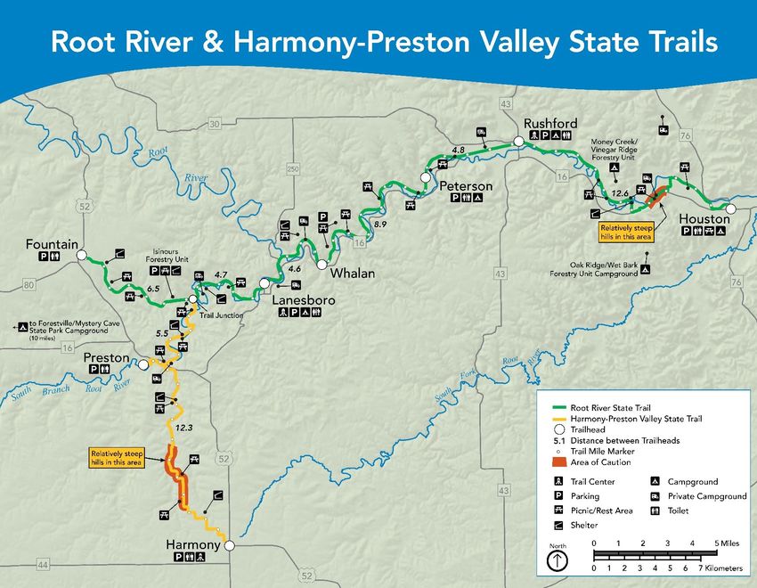
The Minnesota Department of Natural Resources, Parks and Trails Division would like to thank all who
participated in this master planning process. Individuals and community leaders in Harmony have been
working for many years to help establish this trail extension. Many DNR staff, city, county, and state
officials, trail association members, and local citizens contributed their time and energy to the planning
process as well.

                           DNR Parks and Trails Region 3 staff and trail crew. (2018)

The Minnesota DNR prohibits discrimination in its programs and services based on race, color, creed, religion,
national origin, sex, marital or familial status, disability, public assistance status, age, sexual orientation, and local
human rights commission activity. Individuals with a disability who need a reasonable accommodation to access or
participate in DNR programs and services please contact the DNR ADA Title II Coordinator at info.dnr@state.mn.us,
651-296-6157. For TTY/TDD communication contact us through the Minnesota Relay Service at 711 or 800-627-
3529. Discrimination inquiries should be sent to Minnesota DNR, 500 Lafayette Road, St. Paul, MN 55155-4049.

This document is available in alternative formats to individuals with disabilities by contacting
info.dnr@state.mn.us, 651-296-6157. For TTY/TDD communication contact us through the Minnesota Relay
Service at 711 or 800-627-3529.

©2021, State of Minnesota, Department of Natural Resources

Printed on recycled paper containing a minimum of 10 percent post-consumer waste and vegetable-based ink.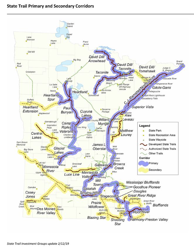
Harmony - Preston Valley State Trail Master Plan Amendment, 2021                                                                        WORKING DRAFT

Master Plan Amendment Outline [Working DRAFT – Public Review]
Contents
Purpose ......................................................................................................................................................... 3
Background – Trail Overview ........................................................................................................................ 3
   Overview of the Harmony-Preston Valley State Trail ............................................................................... 3
       Root River State Trail to Preston........................................................................................................... 3
       Preston to County Road #16 ................................................................................................................. 3
       County Road #16 to Harmony............................................................................................................... 4
       Trailhead in Harmony............................................................................................................................ 4
Legislative Authorization............................................................................................................................... 4
Trail Development History ............................................................................................................................ 6
   Minnesota Parks and Trails System Plan and Harmony-Preston Valley State Trail .................................. 7
Proposed Extension ...................................................................................................................................... 9
   Proposed Route ........................................................................................................................................ 9
       Niagara Cave ......................................................................................................................................... 9
       Iowa Recreational Trails ........................................................................................................................ 9
   Trail Uses – Existing and Proposed ......................................................................................................... 10
Justification ................................................................................................................................................. 12
Trail Management ....................................................................................................................................... 14
   Trail Management ................................................................................................................................... 14
   Information and Education ..................................................................................................................... 14
Natural Resources ....................................................................................................................................... 14
   Ecological Classification System .............................................................................................................. 14
       Rochester Plateau Subsection ............................................................................................................ 15
   Threatened, Endangered or Special Concern Species and Ecological Features ..................................... 17
   Water Resources and Karst ..................................................................................................................... 18
Climate Change ........................................................................................................................................... 19
References .................................................................................................................................................. 20
Appendix A: Trail Usage Summary .............................................................................................................. 21
Appendix B – Public comment summary .................................................................................................... 24

HPVST Amendment, Working Draft                                            July, 2021                                                                        pg. 1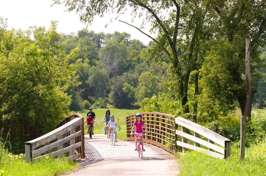
Harmony - Preston Valley State Trail Master Plan Amendment, 2021                                                           WORKING DRAFT

Figures and Tables
Figure 1. Root River and Harmony-Preston Valley State Trail Map Guide. ................................................. 5
Figure 2. City of Harmony, Minnesota, street map. ..................................................................................... 6
Figure 3. State Trail System – Primary and Secondary Corridors (Authorized and developed state trails
map, System plan State Trail Update, 2019) ................................................................................................ 8
Figure 4. HPVST Proposed Extension, details/resources as needed. ......................................................... 13
Figure 5. ECS Subsections Map. .................................................................................................................. 16

Table 1. Proposed Development, Management Recommendations and Features. .................................. 11

HPVST Amendment, Working Draft                                     July, 2021                                                                pg. 2
Harmony - Preston Valley State Trail Master Plan Amendment, 2021                              WORKING DRAFT

Purpose
The purpose of this master plan amendment is to address the extension of the Harmony-Preston Valley
State Trail from the City of Harmony to the Minnesota-Iowa state border, including a connection to
Niagara Cave, in Fillmore County. The trail extension is proposed to be a 10-foot wide bituminous
(asphalt- paved) trail for a distance of approximately 5.5 miles, with a trail segment, approximately 0.5
mile long, connecting to Niagara Cave. This document amends the Harmony-Preston Valley Trail Master
Plan, approved April, 1995. The fully developed Harmony-Preston Valley State Trail will consist of
approximately 24 miles, from its intersection with the Root River State Trail (north of Preston) to the
Minnesota-Iowa state border and Niagara Cave.
This amendment will provide additional year-round recreational trail opportunity, extending from
Harmony to the Minnesota-Iowa state border. While the Harmony – Preston Valley State Trail will
terminate at the state border, it is anticipated to connect to recreational trails in Iowa. The Iowa trail
system includes a proposed connection to the Harmony – Preston Valley State Trail and may also
connect to other trails and recreational areas along the Upper Iowa River and in the communities of
Cresco and Decorah, Iowa. The proposed interstate trail systems is estimated to combine over 100 miles
of recreational trails in southern Minnesota and northern Iowa.
The Harmony-Preston Valley State Trail will continue to be developed and managed for non-motorized
uses, consistent with the previously developed segments of the Harmony-Preston Valley State Trail,
including walking/hiking, bicycling and in-line skating, and cross country skiing.

Background – Trail Overview
Overview of the Harmony-Preston Valley State Trail
Currently, the Harmony-Preston Valley State Trail is an 18 mile, paved (bituminous) trail that connects
the communities of Harmony and Preston to the Root River State Trail in Fillmore County. It is a multi-
use, non-motorized trail, with the predominate uses consisting of bicycling, walking/hiking, in-line
skating and cross-country skiing.
The northern two-thirds of this trail is constructed on an abandoned railroad grade and is generally level
and wheelchair accessible. The southern segment between County Road 16 and Harmony was not
constructed on an abandoned railroad grade, and is comparatively more challenging with varying
terrain.

Root River State Trail to Preston
The Root River State Trail joins the Harmony-Preston
Valley State Trail at the Isinours Junction. For the 5.6
miles south to Preston, the trail travels through wooded
areas and farmland, crossing and winding alongside
Watson Creek and the South Branch of the Root River.

Preston to County Road #16
The trail continues south out of Preston for another 3.9
miles until it intersects County Road 16. The trail
meanders alongside Camp Creek for much of this
                                                             A family enjoying the Harmony-Preston Valley State
section, allowing for recreational opportunities for
                                                             Trail, Harmony Trailhead Park, Harmony, MN.
anglers and access to trout fishing.

HPVST Amendment, Working Draft                  July, 2021                                                    pg. 3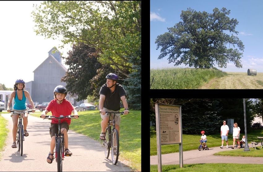
Harmony - Preston Valley State Trail Master Plan Amendment, 2021                               WORKING DRAFT

County Road #16 to Harmony
The southern 8.5 miles of the existing trail, still continuing south, climbs out of the valley and zig-zags
along a ridgeline to Harmony. This portion of the trail was not constructed on an abandoned railroad
grade and follows more challenging terrain, including one rather strenuous incline that may not be
suitable for all trail users. Scenery along the trail consisting mainly of farmland and rolling terrain, while
scattered sinkholes and small wooded areas present diversity, opportunities for resource interpretation
and points of interest along the trail.

Trailhead in Harmony
The trailhead in Harmony is located in
Harmony’s central business district, just
west of Highway 52 on 1st Avenue, near the
Harmony Visitor Center. The parking lot
entrance to Harmony-Preston Valley
Trailhead Park is off of 4th St NW, just east
of 2nd Ave NW. Public parking, picnic tables,
a playground, informational and educational
signage, and public restrooms are located at
the trailhead park. Local dining, lodging and
entertainment in the City of Harmony is
                                                  Harmony-Preston Valley Trailhead Park, Harmony, MN.
within a short distance of the trailhead park.

Legislative Authorization
The Harmony-Preston Valley Trail is part of the Blufflands Trail System, and was originally authorized in
1992. The statute was amended in 2015, (1st Special Session, Chapter 4, S.F. No. 5, Sec. 34), to include
connections to the Iowa border and Niagara Cave (Minnesota Statutes 85.015, Subd. 7).
      (a) The Root River Trail shall originate at Chatfield in Fillmore County, and thence
          extend easterly in the Root River Valley to the intersection of the river with
          Minnesota Trunk Highway No. 26 in Houston County, and extend to the
          Mississippi River.
      (b) Additional trails may be established that extend the Blufflands trail system to
         include La Crescent, Hokah, Caledonia, and Spring Grove in Houston County;
         Preston, Harmony, Fountain, Wykoff, Spring Valley, Mabel, Prosper, Canton,
         Ostrander, and connections to the Iowa border including a connection to
         Niagara Cave in Fillmore County; Rochester, Dover, Eyota, Stewartville, Byron,
         and Chester Woods County Park in Olmsted County; and Winona, Minnesota
         City, Rollingstone, Altura, Lewiston, Utica, St. Charles, and Elba in Winona
         County. In addition to the criteria in section 86A.05, subdivision 4, these trails
         must utilize abandoned railroad rights-of-way where possible.
      (c) The trails shall be developed primarily for non-motorized riding and hiking.

HPVST Amendment, Working Draft                    July, 2021                                              pg. 4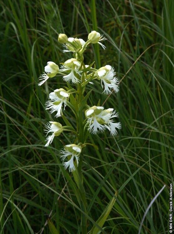
Harmony - Preston Valley State Trail Master Plan Amendment, 2021                     WORKING DRAFT

Figure 1. Root River and Harmony - Preston Valley State Trail Map Guide.

                                                                                                     © MN DNR 2014

   HPVST Amendment, Working Draft                                          July, 2021            pg. 5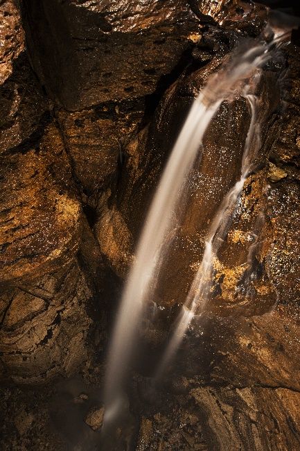
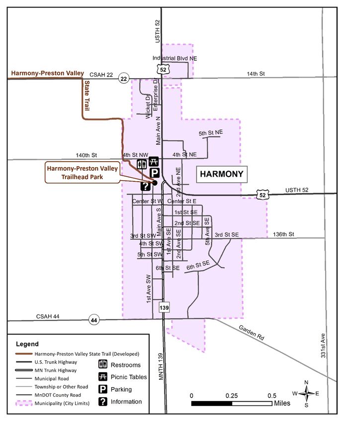
Harmony - Preston Valley State Trail Master Plan Amendment, 2021                      WORKING DRAFT

Figure 2. City of Harmony, Minnesota, street map.

Trail Development History
In 1989, the cities of Harmony and Preston developed trail plans for their respective communities. In 1990,
the Harmony-Preston Area Trail Commission Joint Powers Board was established to initiate the
development of a public, non-motorized recreational trail system that would connect the two communities,
which was initially known as the Camp Creek Trail. Trail uses were envisioned to include hiking, biking and
cross-country skiing.

HPVST Amendment, Working Draft                 July, 2021                                          pg. 6
Harmony - Preston Valley State Trail Master Plan Amendment, 2021                          WORKING DRAFT

Local efforts continued to build interest and support for the trail. In 1992, the Minnesota Legislature
authorized the Harmony-Preston Valley State Trail, by including language as part of the Blufflands Trail
System, Minnesota Statutes 85.015, Subd. 7 (b).
                                          After becoming an authorized state trail, state funding was
                                          secured through the Legislative Commission on Minnesota
                                          Resources (LCMR, 1992) and through state bonds (1994).
                                          In 1993, DNR staff began developing the Harmony-Preston Valley
                                          State Trail Master Plan, and was then approved [completed] in
                                          April 1995. While the master plan was in progress, land
                                          acquisitions and appraisals were underway/completed, allowing
                                          for development to begin shortly after the approval of the master
                                          plan.
                                              Construction of the trail segment began in 1997 and the
                                              bituminous (paved) trails surface was completed in 1998 from
                                              Harmony to the Root River State Trail, north of Preston. Also in
                                              1998, the Trailhead Park was constructed in the City of Harmony,
Bicycling on the Harmony-Preston Valley State
Trail.                                        which serves the community, trail users and other visitors.

Minnesota Parks and Trails System Plan and Harmony-Preston Valley State Trail
In 2015, the DNR Division of Parks and Trails adopted the Minnesota
State Parks and Trails System Plan. The system plan advances new               The Harmony – Preston
approaches for managing state parks, state recreation areas, state trails,     Valley State Trail is
forest recreation areas and water recreation. The plan recommended a           designated as a Primary
differentiated approach to managing these recreation systems – to
                                                                               Corridor in the Minnesota
focus on providing different types of recreational experiences and a
range of facilities and levels of services at units across the system. The
                                                                               State Parks and Trails
intended outcome is that visitors will have a wider range of high-quality      System Plan (2015; and
opportunities from which to choose those that best match their                 Updated 2019).
interests and expectations.
The system plan and implementation guidelines organized and prioritized state trails into primary and
secondary corridors (2019). Each corridor contains multiple trails that together create long-distance trail
connections and opportunities. Primary corridors are considered the first priority for investments that the
division makes across the state trail system. Secondary corridors will be a lower priority for investment,
whereas the division will seek partners to take a larger role in developing and managing these trails. The
Harmony-Preston Valley State Trail, including the extension to the Minnesota-Iowa state border and
Niagara Cave, is identified as a primary corridor. (See Figure 3 on following page) As described by the
system plan:
        Primary corridors will be the first priority for investments that the division makes across the state
        trail system. These trails will be the highest priority for new development, rehabilitation and
        trailhead amenities. Trails may have additional amenities, interpretation, programs or events.
        Partners may complete some basic trail maintenance, and may provide trail amenities and services
        above the division’s baseline level of service.

HPVST Amendment, Working Draft                   July, 2021                                             pg. 7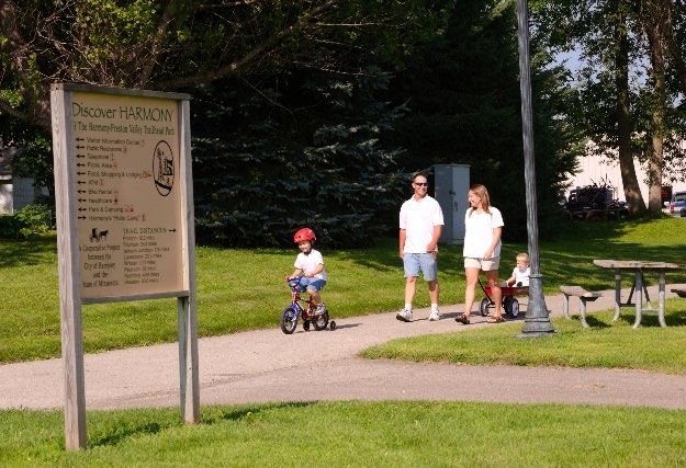
Harmony - Preston Valley State Trail Master Plan Amendment, 2021             WORKING DRAFT

Figure 3. State Trail System Map, Minnesota State Parks and Trails System Plan, 2019 Updates.

HPVST Amendment, Working Draft            July, 2021                                    pg. 8
Harmony - Preston Valley State Trail Master Plan Amendment, 2021 WORKING DRAFT
Proposed Extension
Proposed Route
The existing Trailhead Park in Harmony serves as a trailhead facility for the Harmony-Preston Valley State
Trail. This facility include a large parking lot, public restrooms, playground, picnic areas and is walking
distance to local dining and the downtown business district.
A locally designated bike route is proposed to link this trailhead park and facility, at the northern edge of
Harmony, with the continuation of the state trail at the intersection with County Highway 44, at the
southern edge of the business district. This route is just under a mile long, approximately 0.9 mile.
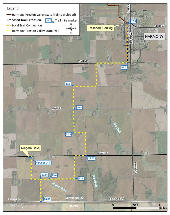
The state trail extension begins near the intersection of County Highway 44 and 1st Avenue SW, then
continues west approximately 0.6 mile before turning south. The trail continues south, across gently rolling
terrain between active agricultural fields, crossing 120th Street and County Highway 30. Approximately 0.5
mile south of County Highway 30, the trail heads west again before one segment turns south to end at the
Iowa Border, and one segment continues west then turns north to end at
Niagara Cave and County Highway 30. (See Table 1 for more details; Figure 4
for a map of the proposed route.)
Niagara Cave
Niagara Cave is a privately owned and operated geological attraction in
Fillmore County, located approximately 5 miles from Harmony. The cave
features an underground stream, 60-foot waterfall, stalactites, stalagmites, and
ancient fossils over 400 million years old. The temperature in the cave remains
at a constant of 48 degrees Fahrenheit during the cave tour season, which runs
from April to October. Niagara Cave receives about 25,000 to 30,000 visitors
per year. Admission fees apply (note: this is not a state-owned or operated
property). The proposed Harmony – Preston Valley State Trail extension will
©Niagara Cave
provide a safe recreational trail connection to Niagara Cave.
Niagara Cave, main passage.
Iowa Recreational Trails
Recreational trail systems in neighboring Iowa have expressed interest and provided support for connecting
to the Minnesota state trail system. DNR will continue to coordinate with trail planning efforts in Iowa,
which may provide additional recreational opportunities in the area and potential trail connections to the
Harmony-Preston Valley State Trail.
Howard County, Iowa, includes an established system of recreational trails in and around the City of Cresco.
The local community has expressed interest in connecting to other nearby communities, including
Harmony, MN. The Prairie Springs Recreation Trail is a 3.5 mile paved, non-motorized trail, spanning from
downtown Cresco to Vernon Springs (south of Cresco) along Prairie’s Edge Nature Center. Howard County
is actively leading a trail feasibility study to consider potential trail routes that could connect Cresco to
Niagara Cave, including a possible connection with the Harmony – Preston Valley State Trail.
Winnesheik County, Iowa, includes City of Decorah which is located approximately 25 miles south of
Harmony, along Highway 52. Decorah has a number of recreational parks and trails offering year round
uses. Trout Run Trail is an 11-mile, paved loop that circles the City of Decorah The trail crosses trout
streams five times, follows a segment of the Upper Iowa River (a trout stream), and passes Siewer Springs
Trout Hatchery. Trout Run Trail is available for year-round recreational uses including biking,
walking/hiking, inline skating and intermediate to advanced level cross country skiing. The Prairie Farmer
Recreational Trail is a paved, multi-use recreational trail developed along the abandoned Milwaukee
HPVST Amendment, Working Draft July, 2021 pg. 9Harmony - Preston Valley State Trail Master Plan Amendment, 2021 WORKING DRAFT
Railroad line, connecting the communities of Cresco, Ridgeway and Calmar, Iowa, for a length of
approximately 20 miles. Potential connections to Minnesota have been discussed among trail users in
Decorah, Iowa, with interest in connecting directly to the Harmony-Preston Valley State Trail, or to nearby
communities, such as Harmony or Canton, Minnesota.
Trail Uses – Existing and Proposed
The Harmony-Preston Valley State Trail currently accommodates hiking, bicycling and in-line skating along
its paved surface and is maintained and groomed for cross-country skiing from Isinours Junction to County
Road 16, as conditions allow. Snowmobiling is not currently allowed on the Harmony-Preston Valley State
Trail.
The proposed extension from Harmony to the Minnesota-Iowa state border will remain consistent with
existing uses, allowing hiking, bicycling and in-line skating. This segment will also allow for cross-country
skiing, as conditions allow. Snowmobiling is not allowed on the proposed extension from Harmony to
Niagara Cave and the state border.
The following recommendations are added to the Harmony-Preston Valley State Trail Management Plan
(1995):
Recommendation: Minnesota DNR will coordinate with communities and trail organizations in Iowa for
potential trail developments at or to the shared state border, in support of a continuous recreational trail
experience and system in this region.
Recommendation: Trail uses on the proposed extension should remain consistent with the existing
recommended trail uses for the Harmony – Preston Valley State Trail, and will be managed in the same
manner, as applicable and appropriate.
Adults and kids bicycling on the Harmony-Preston Valley State Trail, south of Preston.
HPVST Amendment, Working Draft July, 2021 pg. 10Harmony - Preston Valley State Trail Master Plan Amendment, 2021 WORKING DRAFT
The following description for the proposed trail extension from Harmony to the Minnesota-Iowa state
border is a continuation of the “Proposed Development and Management Recommendations” from the
Harmony-Preston Valley State Trail Master Plan (1995). *The proposed extension description begins in
Harmony, at the Trailhead Park. (The master plan identifies this location as mile post 18.0, however, the
developed trail ends at approximately mile 17.8.)
Table 1. Proposed Development, Management Recommendations and Features
Segment 4 Harmony to Minnesota-Iowa State Border (Proposed Extension)
(Approximate
mile post)
Mile 17.8* – 18.7 Local Trail Connection. Proposed local trail connection from Harmony Trailhead
Park (north end of the city) to County Highway 44 (south end of the city). This
will be a City of Harmony Trail route, connecting the two segments of the
Harmony – Preston Valley State Trail.
Mile 18.7 – 20.8 HPVST Extension. Proposed trail extension begins on south side of County
Highway 44, west of MN Highway 139/Main Street. The proposed trail will be
parallel to County Highway 44 for approximately 0.6 miles heading west, then
turning south through agricultural fields.
Mile 18.7 – 20.8 Vegetation Management. This section includes wetlands and an agricultural
landscape. Restoring native prairie through this section would provide visual
interest for the trail user and help retain snow cover on the trail. In addition, the
permanent vegetative cover would slow wind speeds and filter runoff, reducing
erosion.
Mile 20.8 Road Crossing. A road crossing is required at 120th Street. An at-grade crossing is
proposed; alternatives may be considered.
Mile 20.8 – 22.05 Vegetation Management. The trail continues through an agricultural landscape.
Retaining existing tree cover and planting native vegetation is recommended.
Mile 22.05 Road Crossing. An at-grade crossing is proposed across County Highway 30;
alternatives may be considered. (Trail will parallel road for approximately 0.25
mi.)
Mile 21.3 – 23.8 Vegetation Management. The trail will be located along fencerows, road rights-
of-ways (parallel), and avoids sinkholes. Restoring prairie through this section is
recommended, where feasible.
Mile 23.4 Water Crossing Required. An unnamed creek (intermittent stream) is identified
as public waters and may require infrastructure for the trail crossing.
Appropriate infrastructure could include a type of culvert or bridge, as specified
through engineering, design and resource considerations at the site.
Mile 23.55 Trail Junction. At this location, orientation signage is needed at the trail junction
to identify two routes: west to Niagara Cave and County Road 30; and, south to
the Minnesota - Iowa state border and Iowa trail systems.
Mile 24.05 Iowa Stateline. Connection to recreational trail systems in Iowa.
[end point] Recommendations include a Welcome to Minnesota interpretive sign.
Up to Mile 24.8 Niagara Cave and County Highway 30. Proposed extension includes a trail
[end point] connection to Niagara Cave, ending at County Highway 30.
HPVST Amendment, Working Draft July, 2021 pg. 11Harmony - Preston Valley State Trail Master Plan Amendment, 2021 WORKING DRAFT
Justification
The proposed segment of the Harmony-Preston Valley State Trail from Harmony to the Minnesota – Iowa
state border, including a connection to Niagara Cave, is consistent with the statutory language that was
amended in 2015 (M.S. 85.015, Subd 7), as well as the criteria for state trail designation outlined in 86A.05,
Subd. 4.
The Harmony Trail Commission was established with local community support in 1989. Over the past 30
years, various individuals have contributed support for trail extension possibilities, including: local
communities, county staff, state and local elected officials, Howard and Winneshiek counties (Iowa)
Business and Tourism; Prairie Springs Recreational Trail; and funding support from the Minnesota
Legislature.
This proposed extension is consistent with the vision and goals presented
in the Harmony – Preston Valley State Trail Master Plan (1995) with the
following statement (page 33): “Future opportunities for trail
connections include the Amish Hills Trail connecting Harmony to Mabel
and Canton; Niagara Cave; and the trails in Iowa.”
The trail extension will provide additional recreational opportunities in
Minnesota and is anticipated to connect with additional recreational trail
systems in southern Minnesota and northern Iowa. Communities that
support recreational trails and respond to the needs of trail users have
experienced positive impacts on their local economies. DNR trail user
surveys and studies indicate that trail users also use local facilities for
eating, shopping and lodging. (Kelly, 2010)
Preliminary results from the 2019 State Trail Visitor Survey highlights the
importance of recreational trails for local communities, with ©Niagara Cave
approximately 60% of tourists noted that a state trail was the primary or
Niagara Cave waterfall.
a significant reason why they visited a community or specific area.
(Wilder Research, 2020). This finding also supports previous trail studies
conducted by MN DNR, which categorized the Root River and Harmony-Preston Valley state trails as high
tourist use trails and reported 70% of trail users were visiting from over 50 miles away. (Kelly, 2010)
The Minnesota DNR Parks and Trails System Plan identifies the Harmony-Preston Valley State Trail corridor
as a Primary Corridor, which is also generally known as a high-use corridor and networks of trails that link
together to help create long-distance recreational connections. These trails are of the highest priority for
new development, such as the proposed extension. Through formal agreements, partners may also provide
basic maintenance and additional or enhanced trail amenities and services. (MN DNR, 2019)
HPVST Amendment, Working Draft July, 2021 pg. 12Harmony - Preston Valley State Trail Master Plan Amendment, 2021 WORKING DRAFT Figure 4. Harmony – Preston Valley State Trail – Proposed Extension Route. HPVST Amendment, Working Draft July, 2021 pg. 13
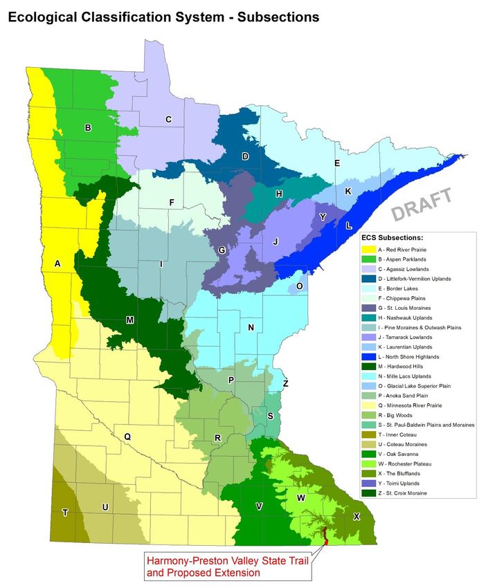
Harmony - Preston Valley State Trail Master Plan Amendment, 2021                          WORKING DRAFT

Trail Management
Trail Management
The proposed extension is intended to remain consistent with existing Harmony – Preston Valley State Trail
management recommendations and updated department and division policies, as applicable and
appropriate.

Information and Education
Incorporating art or sculpture within the trail right of way can be an attractive way to provide interpretive
information about the resources and history of the trail. Practical and functional objects such as benches,
gateways, bridges, water fountains and tables can be designed in a manner that are aesthetically pleasing
while also providing information about the area through design or use of materials. Sculptures for purely
aesthetic purposes may also be an attractive addition to the trail right-of-way. Local trail enthusiasts and
stakeholders have expressed interest to incorporate art or sculpture along the Harmony Preston Valley
State Trail.
The following Trail Management recommendations are added to the existing recommendations provided in
the Harmony-Preston Valley State Trail Management Plan (1995):
Recommendation: When developed, the proposed trail extension should be managed consistent with the
previously developed Harmony – Preston Valley State Trail, for a continuous recreational trail experience
for trail users.
Recommendation: The DNR will coordinate with local communities and local organizations and groups to
consider appropriate and meaningful ways to incorporate art, sculpture, and/or trail-related amenities
within the trail right-of-way.

Natural Resources
Ecological Classification System
Minnesota updated its ecological classification system shortly after the original master plan was approved.
The following description and map provides an update to pages 11-12 of the Harmony-Preston Valley State
Trail Master Plan, 1995.
Minnesota uses an Ecological Classification System (ECS) that is part of a nationwide mapping initiative
developed to improve DNR’s ability to manage all natural resources on a sustainable basis. Both systems
integrate climatic, geologic, hydrologic and topographic, soil and vegetation data. Minnesota lies at the
center of North America where the prairie, boreal forest, and eastern deciduous forest meet. Four major
ecological provinces are represented in Minnesota: Eastern Broadleaf Forest; Laurentian Mixed Forest;
Prairie Parkland; and Tallgrass Aspen Parklands. All four are parts of much larger systems that cover major
areas of central North America. The Eastern Broadleaf Forest Province, primarily consisting of deciduous
forest, extends eastward from Minnesota all the way to the Atlantic Ocean. The Laurentian Mixed Forest
Province, largely consisting of coniferous forest, extends northward into Canada. The Prairie Parkland
Province extends westward into the Dakotas and across the Central Plains of the United States. The
Tallgrass Aspen Parklands Province represents the southern tip of a larger province that extends north and
west into the Canadian Prairie Provinces.
The ecological provinces are further divided into sections and subsections defined by vegetation, geology,
and other resource criteria that make up distinct landscapes. The Harmony-Preston Valley State Trail is

HPVST Amendment, Working Draft                   July, 2021                                           pg. 14
Harmony - Preston Valley State Trail Master Plan Amendment, 2021                            WORKING DRAFT

located within the Blufflands and Rochester Plateau subsections of the Paleozoic Plateau Section in the
Eastern Broadleaf Forest Province in southeastern Minnesota. The trail extension is located entirely within
the Rochester Plateau subsection, described below, which supplements the landscape information
provided in the Harmony-Preston Valley State Trail Master Plan (1995).

        Rochester Plateau Subsection (southern portion of the trail, from just south of County Rd 16 to
        Minnesota-Iowa state border). This subsection consists of level to gently rolling older till plains.
        Topography is controlled by underlying glacial till along the western edge of the subsection, where
        loess is several feet thick. As glacial drift thins to the east, topography is largely bedrock controlled
        (Dept. of Soil Science, Univ. of Minnesota 1973). Sinkholes are common in the southwestern
        portion of the subsection.
        The Rochester Plateau Subsection is an area of level to gently rolling terrain. The subsection
        contains several headwaters, including the Root, Whitewater, Zumbro, and Cannon rivers, as well
        as some cold-water trout streams in the eastern portion. Before conversion to agriculture, the
        predominant vegetation was tallgrass prairie and bur oak savanna. Today, agriculture dominates
        the landscape, with 69 percent in cropland and 21 percent in pasture. Water quality is a concern in
        the subsection because of agricultural and urban development. In the center of the subsection, the
        city of Rochester and the corridor to the Twin Cities metropolitan area are projected to grow
        rapidly over the next decade.

        According to Tomorrow’s Habitat for the Wild and Rare – An Action Plan for Minnesota Wildlife
        (MN DNR 2006), 94 Species in Greatest Conservation Need (SGCN) are known or predicted to occur
        within the Rochester Plateau. These SGCN include 36 species that are federal or state endangered,
        threatened, or of special concern.

        Highlights:
            • Significant portions of this subsection have been developed for agriculture, but publicly
                owned forests and associated streams, rivers and wetlands support a diversity of wildlife.
            • Wildlife present in this subsection includes a variety of reptiles, such as timber
                rattlesnakes, western foxsnakes, racers, Blanding’s turtles and wood turtles; birds,
                including Louisiana waterthrushes, prothonotary warblers, cerulean warblers, blue-winged
                warblers, peregrine falcons; fish, including American brook lampreys and suckermouth
                minnows; and mussels, such as ellipse mussels.
            • Areas important for SGCN include the Richard J. Dorer Memorial Hardwood State Forest;
                Oronoco Prairie, Racine Prairie, and Cherry Grove Blind Valley Scientific and Natural Areas;
                and Carley and Forestville Mystery Cave state parks.

HPVST Amendment, Working Draft                    July, 2021                                             pg. 15
Harmony - Preston Valley State Trail Master Plan Amendment, 2021 WORKING DRAFT Figure 5. Ecological Classification System for Minnesota - Subsections with Proposed Harmony - Preston Valley State Trail Location. (Updated Subsection Map of Minnesota, replaces map on page 12 of HPVSTMP) HPVST Amendment, Working Draft July, 2021 pg. 16
Harmony - Preston Valley State Trail Master Plan Amendment, 2021                            WORKING DRAFT

Threatened, Endangered or Special Concern Species and Ecological Features
The Minnesota Natural Heritage Information (NHIS) database was queried to identify animal and plant
species that are threatened, endangered or of special concern within the vicinity of the proposed trail
corridor. These species are protected by state law, and protecting their habitat must be considered during
trail planning, development and maintenance.
A query of the Natural Heritage Information System (NHIS) database in 2019, the following species and
ecological features are known or expected to occur within one mile of the proposed trail extension route in
Fillmore County. The following text supplements and updates information and recommendations provided
in the HPVST Master Plan (1995):
    •   Eastern spotted skunk (Spilogale putorius): Minnesota status:
        threatened; no federal status Eastern spotted skunks are
        generally smaller than the more common striped skunk. Eastern
        spotted skunks are generally found in open lands with sufficient
        cover, such as fencerows, shelterbelts, thickets, brush, and
        riparian woodlands. In agricultural areas they use buildings,
        corncribs, trash piles, rock piles, and haystacks for cover and den
        sites. Once abundant and regularly taken throughout much of
        the state by trapping, the Eastern spotted skunk was assigned
        special concern status in 1984. Then, in 1996, it was reclassified
        as threatened. Special attention should be given to documenting
                                                                              Photo of Eastern spotted skunk.
        sightings or accidental captures of the eastern spotted skunk.

    •   Timber rattlesnake (Crotalus horridus): Minnesota status: Threatened; no federal status
        Updated status since HPVST Master Plan was completed in 1995.) The timber rattlesnake is a large,
        heavy-bodied rattlesnake native to the bluffs of southeastern Minnesota. This snake has a wide,
        triangular-shaped, unmarked tan head and a narrow neck. Its background color can range from
        yellowish tan to brown to gray, and is marked with dark brown to black crossbands (chevrons). Its
        tail is black with a tan rattle, which is typically held perpendicular to the ground. In Minnesota,
        timber rattlesnakes typically have a rust-colored stripe down the center of the back. This color may
        vary throughout its range and within Minnesota. Newborn timber rattlesnakes are grayer in color
        and are born with a button rattle.

        Timber rattlesnakes live among the steep, rugged bluffs of
        southeastern Minnesota. Historically, timber rattlesnakes
        occurred in eight counties in southeast Minnesota.
        However, recent surveys indicate many dens in the
        northern portion of its historic range are extirpated. The
        population’s stronghold in the state has been reduced to
        the far southeastern counties of the state. Population
        declines are due to continued persecution, habitat
        deterioration, road mortality, and predation, particularly by
        birds of prey. Timber rattlesnakes overwinter in ancestral,
                                                                        Photo of Timber rattlesnake.
        communal dens in rock fissures and crevices that reach
        below the frost line. These dens are typically located on
        south to west facing bluff prairies.

HPVST Amendment, Working Draft                   July, 2021                                               pg. 17
Harmony - Preston Valley State Trail Master Plan Amendment, 2021 WORKING DRAFT
• Western prairie fringed orchid (Platanthera praeclara):
Minnesota status: Endangered; Federal status: Threatened
The Western prairie fringed orchid has a showy open raceme
of up to 24 white to creamy white flowers, each with a long
nectar spur. The lip, or lower petal, of each flower is deeply 3-
lobed and fringed. The single, smooth stem is up to 85 cm (34
in.) tall. Flowering plants have 3 or more smooth, elongate
leaves. Non-flowering plants have 1-3 leaves of similar
appearance. The western prairie fringed orchid occurs almost
exclusively in remnant native prairies and sedge meadows. The
majority of sites occur in full sunlight on moist, calcareous till
or sandy soils. It is rare today because of the widespread
conversion of its native prairie habitat to agricultural uses. It is
pollinated by moths and blooms in July.
Photo of Western prairie fringed orchid.
Water Resources and Karst
The proposed extension route intersects several intermittent streams
where a culvert may be necessary to manage water flow and in some locations, such as where streams
intersect roads, culverts are already in place. Water resources that intersect the proposed route include
Deer Creek; Elliot Creek [flows under County Highway 30, trail will be parallel to road, culvert in place
allows stream to flow under road]; and an Unnamed Creek [located near mile marker 23.4.]
Karst is a landscape-scale hydrologic system formed in soluble bedrock. Water chemically and mechanically
enlarges passages, resulting in conduits through which it can rapidly, traveling at speeds of up to several
miles per day. Certain bedrock layers (those that are limestone, dolostone or heavily cemented with
calcium carbonate) are more prone to karst formation and the resulting aquifers are called karst systems.
Sinkholes are direct connections from the land surface to the groundwater system. Stream sinks are points
where streams disappear underground into the groundwater system and sinking streams are reaches of
surface watercourses which lose water to underground drainage. These are all critical connection points
between the land surface and the groundwater systems.
The following Natural Resource recommendations are added to the existing recommendations provided in
the Harmony-Preston Valley State Trail Management Plan (1995):
Recommendation: Avoid threatened, endangered and special concern species. Data from the Natural
Heritage database was used to assess the location of threatened, endangered and special concern species.
Parks and Trails Division staff will keep current with this data and conduct surveys as necessary, prior to
development and construction activities.
Recommendation: Update existing vegetation management plans to incorporate the new trail extension
route and keep up to date with best management practices along entire trail corridor.
HPVST Amendment, Working Draft July, 2021 pg. 18Harmony - Preston Valley State Trail Master Plan Amendment, 2021 WORKING DRAFT
Climate Change
This section provides an update to the Harmony-Preston Valley State Trail Master Plan (1995), and should
be considered additional information about climate and planning for climate changes that were not
addressed in 1995. Since 2014, it is DNR Policy to address climate change in master plans, per Operational
Order #131.
Climate change in Minnesota is evidenced by patterns such as increased temperatures and precipitation
levels, more frequent extreme rain events, and cold weather warming. Between 1895 and 2017, Minnesota
became 2.7° Fahrenheit (F) warmer and 3.4 inches wetter. In southern Minnesota, the frequencies of -25° F
readings have fallen by up to 90 percent, and 9 of the 10 warmest Minnesota winters took place between
1980 and 2018. Moreover, rains that would historically be considered within the largest 2% of rainfalls are
becoming more common, and precipitation in Minnesota is projected to increase by more than 15% by
mid-century.
The DNR aims to enhance ecosystem resiliency and reduce negative impacts of climate change by
incorporating adaptation strategies, reducing or offsetting greenhouse gas emissions, cooperating with
stakeholders, and developing employee knowledge. In accordance with Operational Order #131, “Climate
Adaptation and Mitigation in Natural Resource Management,” the DNR must use the best available science
to develop and implement climate change adaptation strategies, and use water and land management
practices that sustain Minnesota’s natural resources while helping to reduce future climate change by
mitigating the environmental impacts of increased carbon emissions.
Climate change may impact trail infrastructure, management, and recreational use:
• Rising temperatures and declining winter snowfall may affect seasonal use of the trail, potentially
reducing the feasibility of winter (snow-based) recreation activities, while extending the spring and
fall seasons for traditional summer uses.
• Wetter conditions, and more frequent extreme heavy rainfall may cause trout streams to become
muddy, affecting trout populations and trout fishing in southeastern Minnesota.
• Increased precipitation and heavy rainfalls may damage trail infrastructure as ground saturation
and flooding become more common.
• Shorter winters and declining snowfall may affect funding for cross-country skiing, and other winter
recreation activities.
• Winter staffing may need to be adjusted if dedicated funds are impacted by changing climatic
conditions.
The following Climate recommendations are added to the Harmony-Preston Valley State Trail Management
Plan (1995):
Recommendation: Be adaptive to the changing climate and provide year-round, sustainable recreational
uses of the trail corridor, ensuring outdoor recreation opportunities for future generations.
Recommendation: Follow Operation Order #131 and current Parks and Trails Division guidelines developed
for climate change adaptation, mitigation, and management approaches specific to state parks and trails.
HPVST Amendment, Working Draft July, 2021 pg. 19Harmony - Preston Valley State Trail Master Plan Amendment, 2021 WORKING DRAFT References Iowa Trails. http://www.howard-county.com/iowa/recreational-trails.html Website accessed December, 2019. Iroc Web Design Services - Www.irocwebs.com. “Howard County Recreational Trails.” Howard County Economic Development: Howard County, Iowa | Cresco, Iowa | Riceville, Iowa | Elma, Iowa | Lime Springs, Iowa | Protivin, Iowa | Chester, Iowa, www.howard-county.com/iowa/recreational-trails.html. Kelly, Tim. (2010). Status of Summer Trail Use (2007-09) on Five Paved State Bicycle Trails and Trends Since the 1990s. Minnesota Department of Natural Resources, Office of Management and Budget Services. Minnesota Department of Natural Resources, 1995. Harmony-Preston Valley State Trail Master Plan Minnesota Department of Natural Resources, Trails and Waterways Unit. Minnesota Department of Natural Resources, 2006. Tomorrow’s Habitat for the Wild and Rare: An Action Plan for Minnesota Wildlife, Comprehensive Wildlife Conservation Strategy. Minnesota Department of Natural Resources, Division of Ecological Services. [Blufflands Subsection Profile; Rochester Plateau Subsection Profile.] Minnesota Department of Natural Resources, 2019. System Plan Guidance: Combined Workgroup Products. Minnesota Department of Natural Resources, Parks and Trails Division. Minnesota Department of Natural Resources, August, 2015; February 2019. Minnesota Parks and Trails, System Plan Charting a course for the future. Minnesota Department of Natural Resources, Parks and Trails Division. Minnesota Department of Natural Resources, Division of Ecological and Water Resources. 2018. Rare Species Guide: an online encyclopedia of Minnesota's rare native plants and animals. Minnesota Department of Natural Resources, St. Paul. www.dnr.state.mn.us/rsg. Accessed November, 2019. Minnesota Department of Natural Resources. 2009. Timber Rattlesnake recovery plan (Crotalus horridus). Minnesota Department of Natural Resources, Division of Ecological Resources. 47 pp. Niagara Cave. https://niagaracave.com/index.html Website accessed December, 2019. Parks and Trails Council of Minnesota, 2018. Minnesota State Trail User Count, 2018 Report. Parks and Trails Council of Minnesota. Upper Iowa River Alliance. Upper Iowa River Watershed, Recreation Guide. https://upperiowariver.org/recreation/ Website accessed January, 2020. Wilder Research. 2020. 2019 State Trail Visitor Study. Minnesota Department of Natural Resources, parks and Trails Division. HPVST Amendment, Working Draft July, 2021 pg. 20
Harmony - Preston Valley State Trail Master Plan Amendment, 2021                           WORKING DRAFT

Appendix A: Trail Usage Summary

The Parks and Trails Council of Minnesota (PTCMN) is a statewide non-profit organization dedicated to
acquiring, protecting and enhancing critical land for the public’s use and benefit. The P&TC started counting
trail users on Minnesota state trails in 2015 as part of an ongoing project to provide useful data to
managers, legislators, and the public. Results from the trail user counts from 2017 were summarized by the
PTCMN in The Minnesota State Trail User Count, 2018 Report.
The data in The Minnesota State Trail User Count report was collected during 2017 on five state trails: the
Gateway State Trail and Brown’s Creek State Trail in the Twin Cities Metropolitan Area, the Paul Bunyan
State Trail between Brainerd and Walker, and the Root River State Trail and Harmony-Preston Valley State
Trail in southeast Minnesota. All traffic estimates presented in the report are for non-winter, non-
motorized use. “Non-winter” is defined as April through November, to synchronize with the snowmobiling
season, which is statutorily defined as December through March.
The state trail traffic estimates in the report are based on short-duration counts conducted by P&TC at 30
different counting sites along the five different state trails mentioned above. Short-duration counts ranged
in length from 7 days to 25 days and took place between May 12, 2017 and October 24, 2017. All counts
were conducted using automated trail counting equipment that differentiated users as bicyclists or
pedestrians (including equestrians and inline skaters). All traffic estimates were estimated by extrapolating
short-duration counts using the day-of-year factoring method. Estimates are subject to a margin of error of
approximately 10-15%. Additional details regarding the methodology and specific trail user count data is
provided in the report.
The estimated trail user count data specific to the Root River and Harmony-Preston Valley state trails
provided in the PT&C report is summarized below.
The Harmony-Preston Valley State Trail included four different counting sites: South Root River Bridge, Mile
Post 5, County Road 16, and County Road 22. The Root River State Trail included nine different counting
sites between Fountain and Houston.
In 2017, the Root River and the Harmony-Preston Valley state trails received varied non-winter (April –
November) traffic volumes, estimated between 10,332 (County Road 16) and 85,308 (Lanesboro) trail
users. Non-winter traffic volumes above 30,000 were concentrated between Preston and Whalen, with the
highest number of users (more than 75,000) near Lanesboro. (PTCMN, 2018)
Specific to the Harmony-Preston-Valley State Trail, non-winter trail counts were estimated to be between
36,997 and 10,332 from Isinours Junction to Harmony, with the highest traffic volumes most prominent
just south of Isinours Junction, at the South Root River Bridge. (PTCMN, 2018)
According to DNR studies, the Root River and Harmony-Preston Valley state trails are historically
categorized as high tourist use trails, with a reported 70 percent of trail users visiting from over 50 miles
away. (Kelly, T., 2010)
The majority of non-winter trail system use, or 69%, happens during the summer (Memorial Day – Labor
Day), with peak traffic (about 128 daily users) in July. Weekends are the busiest time of week during non-
winter months, while mid-week (Wednesday) is the slowest. The average daily traffic count on Saturdays
was measured at 146 users in the summer, and 68 users in the spring and fall. (PTCMN, 2018)

HPVST Amendment, Working Draft                    July, 2021                                           pg. 21
Harmony - Preston Valley State Trail Master Plan Amendment, 2021                             WORKING DRAFT

Table A1. Harmony-Preston Valley State Trail Usage by Segment (2017)
(Source: Parks and Trails Council of Minnesota, 2018)

    Trail Segment        Estimated Counts         Percent Traffic       Percent Bicycling    Percent Walking
                                                     Volume
 South Root River                     36,997                     40%                   80%                20%
 Bridge
 Mile Post 5                          32,636                     35%                   83%                17%
 County Road 16                       10,332                     11%                   64%                36%
 County Road 22                       12,765                     14%                   51%                49%
 Totals                               92,730                     100%

Table A2. Tourist and Local Use of the Root River and Harmony-Preston Valley Trails (2008-09)
(Source: Kelly, 2010)

          Trail & Year          Median miles of users          Percent of use from       Percent of use from
                                    from home                 within 10 miles of the    over 50 miles from the
                                                                       trail                     trail
 RR-HPV 2008-09                                         120                       9%                   70.00%

Table A3. Monthly Traffic Volumes of Root River and Harmony-Preston Valley Trails (2017)
(Source: Parks and Trails Council of Minnesota, 2018)

           Month               Traffic at average
                                 counting site
 April                                             30
 May                                               97
 June                                            132
 July                                            222
 August                                          161
 September                                       167
 October                                           72
 November                                           7

HPVST Amendment, Working Draft                      July, 2021                                         pg. 22
Harmony - Preston Valley State Trail Master Plan Amendment, 2021 WORKING DRAFT
Table A4. Weekly Traffic Volumes of the Root River and Harmony-Preston Valley Trails (2017)
(Source: Parks and Trails Council of Minnesota, 2018)
Day of week Traffic at average counting site Traffic at average counting site
(summer) (spring/fall)
Monday 155 28
Tuesday 111 25
Wednesday 85 30
Thursday 108 46
Friday 166 69
Saturday 370 132
Sunday 382 93
HPVST Amendment, Working Draft July, 2021 pg. 23Harmony - Preston Valley State Trail Master Plan Amendment, 2021 WORKING DRAFT Appendix B – Public comment summary [Intentionally blank - To be determined] HPVST Amendment, Working Draft July, 2021 pg. 24
You can also read