HAYES LANE, SLINFOLD, WEST SUSSEX - AN ARCHAEOLOGICAL DESK-BASED ASSESSMENT FOR ALFRED MCALPINE HOMES SOUTHERN LIMITED - SEPTEMBER 2000
←
→
Page content transcription
If your browser does not render page correctly, please read the page content below
Hayes Lane, Slinfold,
         West Sussex

 An Archaeological Desk-Based Assessment

for Alfred McAlpine Homes Southern Limited

                 by Nicola Powell

     Thames Valley Archaeological Services Ltd

                Site Code HLS00/58

               September 2000
Hayes Lane, Slinfold, West Sussex
An Archaeological Desk-Based Assessment
by Nicola Powell
Report 00/58
Introduction
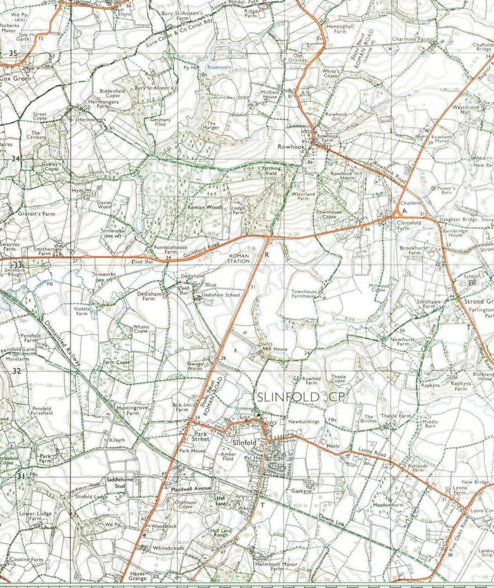
This desk-based study is an assessment of the archaeological potential of a plot of land adjacent to Hayes Lane,
Slinfold, West Sussex (TQ1195 3095) (Fig. 1). This report was commissioned by Mr Andrew Horwood of
Alfred McAlpine Homes Southern Limited, Templars House, Lulworth Close, Chandlers Ford, Eastleigh,
Hampshire, SO53 3TJ. It comprises the first stage of a process to determine the presence/absence, extent,
character, quality and date of any archaeological remains that may be affected by redevelopment of the area.
Site Description, Location and Geology
The site comprises a parcel of land approximately 0.84 hectares in area. It is set back from Hayes Lane and to
the south of the main village centre (Fig. 2). A site visit on 7th September showed that the site is currently
covered with long grass. The northern and western boundaries are formed by the rear gardens of houses in the
village and part of the southern boundary is formed by a disused railway line. Beyond the eastern boundary is
farmland. Hayes Lane runs almost parallel to the A29 to Billingshurst, which follows the course of Stane Street
– the London to Chichester Roman road. The site lies at an average height of about 35m above Ordnance Datum
on land that slopes to the south. The British Geological Survey (BGS 1972) indicates that the site lies on Weald
Clay.
Planning Background and Development Proposals
Approval has been received from Horsham District Council for the erection of 56 houses with garages and access
roads on land off Hayes Lane, Slinfold (Application No. SF/32/99) (see Fig. 8 for development proposals). The
approval is subject to a condition relating to archaeology.
The Department of the Environment’s Policy and Planning Guidance Note Archaeology and Planning (PPG
16 1990) provides guidance relating to archaeology within the planning process. It points out that where a
desktop assessment has shown that there is a strong possibility of significant archaeological deposits in a
1development area it is reasonable to provide more detailed information from a field evaluation so that an
appropriate strategy to mitigate the effects of development on archaeology can be devised:
Paragraph 21 states:
‘Where early discussions with the local planning authorities or the developer’s own research
indicate that important archaeological remains may exist, it is reasonable for the planning
authority to request the prospective developer to arrange for an archaeological field evaluation to
be carried out….’
Should the presence of archaeological deposits be confirmed, further guidance is provided. Archaeology and
Planning stresses preservation in situ of archaeological deposits as a first consideration, as in paragraph 8 and 18.
Paragraph 8 states:
‘…Where nationally important archaeological remains, whether scheduled or not, and their
settings, are affected by proposed development there should be a presumption in favour of their
physical preservation…’
Paragraph 18 states:
‘Where planning authorities decide that the physical preservation in situ of archaeological remains
is not justified in the circumstances of the development and that the development resulting in the
destruction of the archaeological remains should proceed, it would be entirely reasonable for the
planning authority to satisfy itself… that the developer has made appropriate and satisfactory
provision for the excavation and recording of remains.’
Policies covering archaeology in West Sussex (WSSP 1996) and the Horsham Local Plan (HDC 1997) take a
similar view. The local plan policy EDC27 states:
‘The Local Planning Authority will, where there is a known or potential area of archaeological
importance, require developers to demonstrate that a proposal has been evaluated in terms of its
possible effects upon archaeological features and to include this information as part of their
planning applications.’
‘Where, in exceptional circumstances, permission is granted on sites which are considered to
be of archaeological or historic interest, preservation of remains in situ will be preferred.
Where excavation is agreed to be appropriate, the applicant will be required to arrange for full
investigation and recording and the publication of findings to an acceptable professional
standard. Valuable remains should, where possible, be displayed on site.’
Methodology
The assessment of the site was carried out by the examination of pre-existing information from a number of
sources recommended by the Institute of Field Archaeologists ‘Standards in British Archaeology’, covering
desk-based studies. These sources include historic and modern maps, the West Sussex Sites and Monuments
Record, the National Monuments Record, geological maps, and any relevant publications or reports.
Historical Background
2Slinfold is not mentioned in Domesday Book (1086). Wealden places mentioned in Domesday tended to lie at
the foot of the Chalk Downs escarpment, particularly on the Lower Greensand and in the West Rother Valley
(Brandon 1978, 51). There is only one example of a named estate on the Weald Clay areas of Sussex (ibid.):
‘Moha’ probably refers to Muntham in Itchingfield, to the south-east of Slinfold (ibid., 213). The village name
first appears as Stindefold in 1166 (Ekwall 1960). By the late 14th century the name had evolved to become
Slyndefolde and appears in 1633–4 as Slinffeld (Roberts 1914). Slinfold is one of the Sussex place names formed
from habitative elements, in this case –falod, and means literally ‘fold (side) on a slope’ (Ekwall 1960, 427).
Archaeological Background
As with most areas of the country, West Sussex has a wide range of evidence for settlement and activity for
prehistoric and historic times. Yet, the markedly contrasting geological and topographical areas within the
County appear to have had an important influence on the distribution and density of archaeological sites (VCH
1935; Brandon 1978, 45). In general, the areas occupied by the Weald Clay are not thought to have been
extensive settled and exploited until medieval times (ibid.). However, it is not clear if this overview is derived
from a lack of systematic survey, lack of opportunity for chance finds, e.g. from development, the lack of a soil
type conducive to the formation of cropmarks visible from the air, or from a general absence of pre-medieval
occupation.
Prehistoric
The only prehistoric evidence in the search area is a flintworking site broadly dated to the Mesolithic to Bronze
Age periods found adjacent to a bridle path on Rowfold Farm [Fig. 1, 3].
Roman
Stane Street (Margary 1955, route 15) passes 1km north-west of the site, running from London to Chichester –
the tribal capital of Sussex [16]. Sites associated with the road have also been discovered. The vallum (rampart)
and fossa (ditch) of the Roman station at Alfordean were uncovered during an excavation adjacent to Stane
Street in 1922 [8]. The floors and roof debris found suggest the site was occupied from around AD 100 for
about 275 years. The numismatic evidence backs this up, with coins dating from the 1st to 4th centuries. Earlier,
in 1912, a Roman pavement had been found just north of Alfordean station. A Roman bridge was discovered
during underpinning of the modern bridge [7]; masonry and timber was found, as well as occupation debris from
3the station. Domestic and occupation debris from a previously unknown site was also found during work on a
British Gas pipeline in June 2000 [10]. Find spots include part of the upper half of a quern discovered close to
the Roman road [5] and a gold ring (which may even be pre-Roman) found near Lower Bottle House [13].
Roman material has been found re-used in the building and gardens of Dedisham House [9].
Saxon
A large sherd of pottery found on the bed of a stream is the only evidence of Saxon date in the search area [6].
Medieval
Apart from the documentary sources referred to above, indicating that the settlement has at least medieval
origins, there are no other medieval entries for this area in the SMR. The parish church was built in 1861 but it is
unclear if it had earlier origins.
Post medieval and modern
The area is rich in post-Medieval sites, including a brickworks and three parkscapes. The church of St Peter’s,
built in 1861, lies to the north of the village [2]. A brickworks is recorded in the SMR as remembered in a field
name (to the north of Hill House) on the tithe award [4]. Another brickworks was in operation by 1907 [1]. It is
the closest SMR entry to the proposed development site and shown on recent Ordnance Survey maps to the
south-west, close to Hall Land.
Parks at Slinfold Lodge [12], Wellcross [14] and Rapkins (or Rapkyns) [15] are noted in the SMR. At
Wellcross, aerial photographs recorded features that were probably associated with the parkscape. Also within
the search area are an ice house in the basement of farm buildings at Townhouse Farm [11] and the now
dismantled Guildford to Horsham railway, which exists as a footpath bounding the southern edge of the
development site [17].
The Strood Green Defence of Britain pill box is the only modern entry within the search area [18]. It stands
close to Middle Barn and is recorded as a Type 24.
Cartographic and Documentary Sources
A range of Ordnance Survey and other historical maps of the area were consulted in the West Sussex County
Record Office in order to ascertain what activity had been taking place throughout the site’s later history and
whether this may have affected any possible archaeological deposits within the proposal area (Appendix 2).
4The earliest map consulted showing the site area in any detail was the Tithe Map of 1843. There is no
Inclosure map for the area. The Tithe Map, with its accompanying apportionment, shows the site midway
between Gaskins, Wild Harry’s and Holmbush Farms and the village of Slinfold. The fields were named ‘Six
Acres’ and ‘the field above the Six Acres’. They, and surrounding fields, were owned by Michael Knight and
attached to Wild Harry’s and Holmbush Farms. The site itself covered two fields, with a footpath cutting across
the northernmost field.
The Ordnance Survey First Edition of 1876 shows little change in the field boundaries, although the
Guildford to Horsham railway had been built. The footpath shown on the Tithe map can still be seen. On the
Second Edition of the Ordnance Survey of 1895 the two fields that made up the development area were merged
and the field boundary removed. The Ordnance Survey Third Edition of 1911 shows little change. However, later
additions and revisions by the County Planning Office, in 1954, show development adjacent to Hayes Lane.
Three new roads, Lowfield Road, Streetfield Road and Greenfield Road had been built, reflecting the old field
names. These new roads provided access to new houses and gardens. As the development does not appear on
aerial photographs taken in 1947, it must have been carried between then and 1954. The footpath was still in
evidence.
There is a large gap, 66 years, in the map sequence but the 1975 Ordnance Survey map appears to show no
change in the use of the site during this time. Evidence for short-term use in the intervening period, such as brick
clay quarrying, would have manifested itself as a reduced area of ground. No evidence of ground reduction was
observed during the site visit and the course of the former footpath shown on the map of 1911 (Fig. 6) was still
visible on aerial photographs taken in the 1980s. It seems unlikely that the site had been quarried and used for
landfill to bring its level back up to the present day position.
Streetfield Road has been extended and new houses have now been built in the plot to the north-east of the
site. The Guildford to Horsham railway to the south is now disused and is a public footpath. The footpath shown
cutting the corner of the field on previous maps no longer appears to be in use. This is confirmed by an up-to-
date Pathfinder map, which shows the path now following the field boundary.
Aerial Photography
The aerial photographic collections at West Sussex County Planning Department, Cambridge University
Committee for Aerial Photography and the Aerial Photography Unit of the National Monuments Record were
searched during September 2000. The Cambridge University collection had no coverage for the site. No features
5of archaeological interest were observed on the Planning Department collection. The only feature of use was
observed on a colour photograph taken in 1981, which shows the position of the old disused footpath running
across the north-east corner of the field in 1911. This path was replaced before 1975 by the footpath that follows
the field boundary but it’s presence on the aerial photograph indicates that this area of the site had not been
disturbed in the intervening years. The catalogue from National Monuments Record collection contained 16
entries, all of which were vertical coverage (34 prints). No oblique (specialist) photographs were available. No
features of archaeological interest were observed on these photographs.
Listed Buildings
There are no buildings on the site. However, Slinfold is noted for its unspoilt Georgian houses, many of which
line ‘the Street’.
Discussion
There are several aspects that must be taken into consideration when assessing the archaeological potential of the
development area.
The cartographic evidence has shown that the site does not appear to have been landscaped or quarried and,
if present, archaeological deposits would be in a reasonable state of preservation; typical of the majority of sites
found on cultivated land.
This assessment has shown that there are a small number of finds of archaeological significance within the
environs of the site, most notably those associated with the Roman road. There are no SMR entries for the site
itself or its immediate area and the nearest entries are for the late post-medieval and modern periods; St Peter’s
Church, Slinfold [Fig. 1, 2] (1km to the north) and a modern brickworks [1] 0.5km to the south-west. Roman
activity might reasonably be expected in a zone close to the Roman road, but the road lies over 1km to the east.
Similarly, the site lies on the margins of the present-day village of Slinfold and is presumably located at
some distance form the historic core of the village. The settlement was not mentioned in Domesday Book and
presumably developed only in medieval times. There is, therefore, rather less chance that a middle or late Saxon
origin for the settlement exists, which, because of the process of settlement shift, might not be coincident with a
medieval successor.
The site area, at 0.84 hectares, is not particularly large and the likelihood of archaeological sites being
present by chance is diminished.
6Whilst an absence of archaeological deposits on this site cannot be completely discounted, on the basis of
the evidence presented above, the archaeological potential of the site appears to be low. In conclusion, it is
recommended that there is no further need for archaeological investigation.
References
BGS, 1972, British Geological Survey, one-inch, solid and drift edition, sheet 302, Keyworth
Brandon, P, 1978, The South Saxons, Chichester
Ekwall, E, 1960, The Concise Oxford Dictionary of English Place-Names, Oxford
HDC, 1997, Horsham District Local Plan, Volume 1, Horsham
Margary, I D, 1955, Roman Roads in Britain, 1, London
PPG 16, 1990, Department of the Environment Planning Policy Guidance note 16, Archaeology and Planning,
HMSO
Roberts, R G, 1914, The Place-Names of Sussex, Cambridge
VCH, 1935, Sussex, The Victoria History of the Counties of England, III, London
WSSP, 1996, West Sussex Structure Plan, deposit draft, June 1996 (3rd review), Chichester
7APPENDIX 1: Sites and Monuments Records within c. 2km of the site
No. SMR Ref NGR (TQ) Type Period Comment
1 6174 1160 3080 Brickworks Modern In operation by 1907
2 3627 1176 3158 Church Post-medieval St Peter’s Church
3 3630 1260 3240 Flint working Prehistoric
4 6175 1180 3230 Brickworks Post-medieval Field name on Tithe award
5 3631 1154 3276 Quern Roman Part of upper half
6 3624 1190 3300 Pottery Saxon Large sherd found in stream bed
Masonry and timber uncovered
1. Bridge
7 4340 1179 3308 Roman during underpinning bridge over
2. Occupation debris
River Arun
1. Mansio
8 4343 1173 3305 Roman Alfoldean Roman Station
2. Occupation debris
Roman material reused in
9 3619 1112 3287 Domestic Roman buildings and gardens of
Dedisham House
10 - 1260 3325 Domestic/occupation site Roman Discovered June 2000
11 5254 1230 3260 Ice house Post-medieval At Townhouse Farmhouse
12 2750 1043 3080 Park Post-medieval At Slinfold Lodge
Found near Lower Bottle House,
13 3620 1037 3000 Findspot ?Roman
Slinfold
14 2749 1388 3057 Park Post-medieval At Wellcross
15 2748 1335 3197 Park Post-medieval At Rapkins
16 1930 - Road Roman Stane Street
0807 3456–
17 1911 Railway Post-medieval Now dismantled
1477 2926
18 6542 13317 31677 Pill box Modern -
8APPENDIX 2: Historic and modern maps consulted
1) 1843 Tithe Map (Fig. 3)
2) 1876 First Edition Ordnance Survey, Sussex sheet XIII.6 and 10 1:2500 (Fig. 4 )
3) 1895 Second Edition Ordnance Survey, Sussex sheet XIII.6 and 10 1:2500 (Fig. 5)
4) 1911 Third Edition Ordnance Survey, Sussex sheet XIII.6 and 10 1:2500 (Fig. 6)
5) 1975 Ordnance Survey, Sussex sheets TQ 1030–1130, 1031–1131, 1230–1330, 1231–1331 (Fig. 7)
9SITE
35000
34000
10
7
33000 8 6
9 5
11
3
4
32000 15
16
2 18
31000
12 1
SITE
14
17
13
TQ10000 11000 12000 13000 HLS00/58
Hayes Lane, Slinfold, West Sussex, 2000
Figure 1. Location of site within Slinfold and West
Sussex showing SMR entries.
Reproduced from Ordnance Survey Pathfinder 1246 TQ03/13 1:25000
Ordnance Survey Licence AL52324A000131000
30900
SITE
38900
TQ11800 11900 12000
HLS00/58
Hayes Lane, Slinfold, West Sussex, 2000
Figure 2. Location of site showing current land-use.Slinfold
SITE
`Six Acres’
`The Field
Above the Gaskins
Six Acres Farm
Wild Harry’s
Farm
Holmbush
Farm
HLS00/58
Hayes Lane, Slinfold, West Sussex, 2000
Figure 3. Tithe map, 1843.SITE
HLS00/58
Hayes Lane, Slinfold, West Sussex, 2000
Figure 4. First Edition Ordnance Survey, 1876.SITE
HLS00/58
Hayes Lane, Slinfold, West Sussex, 2000
Figure 5. Second Edition Ordnance Survey, 1895.SITE
HLS00/58
Hayes Lane, Slinfold, West Sussex, 2000
Figure 6. Ordnance Survey, 1911 (revised 1954).SITE
HLS00/58
Hayes Lane, Slinfold, West Sussex, 2000
Figure 7. Ordnance Survey, 1975.31000
SITE
30900
TQ11900 12000
HLS00/58
Hayes Lane, Slinfold, West Sussex, 2000
Figure 8. Location of site showing development
proposals.You can also read