Hazard Risk Analysis Fires - Community Disaster Resilience ...
←
→
Page content transcription
If your browser does not render page correctly, please read the page content below
Hazard Risk Analysis
                                                                                                        Fires
 Brush, Bush and Grass Fires
 Community Interface Fires
 Community Structural Fires
 Forest Fires or Wildfires
 Peat Bog Fires

Fires
This section introduces a number of types of fires: brush, bush and grass fires; forest or wildfires,
peat bog fires, community structural fires and wildland community interface fires. You will note
that for most of these fires there are two risk analyses: one is for those that are caused by nature
(e.g., lightning) and the other is for those caused by people (human-caused). When you come to
developing resilience strategies for these hazards it is important to understand where the main
cause for the hazard lies.

Resources are available to assist you in completing this analysis in the Risk Analysis Resources
section.

Brush, Bush and Grass Fires
Definition
Grass, Bush and Brush Fires, are started by lightning or by humans (either by accident or on
purpose) and occur in bush or brush areas and on grasslands – including prairie grasses.

Discussion
Certain fuel or forest types such as dry needle-bearing trees and grasses burn more easily than
trees which shed leaves every year. Many fires are caused by human activities such as: logging
or lumbering activities, recreational activities, railroads, land clearing and bush burning,
construction and other industrial operations.

It Happened Here…
On March 28, 2020, two grass fires east of Highway 2 caused evacuations in southern Alberta
during Sunday afternoon’s wind storm. RCMP evacuated the Village of Carmangay due to one
fire, describing the blaze as “out of control” and spanning 11 to 16 kilometres across. The village,
located about 60 kilometres north of Lethbridge, has a population of 242. The second grass fire,

                                                                  www.cdrp.jibc.ca
CDRP: Hazard Risk Analysis

on the Blood Reserve, west of Lethbridge, forced the evacuation of approximately 15 homes in
the Fort Whoop-Up area on the east end of the Blood Reserve and caused temporary closures of
a “significant portion” of Highway 509, according to the Blood Tribe.

On April 20, 2019, wind, terrain and dry conditions kept firefighters busy battling a grass fire in
northeast Edmonton as crews were called to the area of Hooper Crescent near Victoria Trail
because of a brush fire in the Kennedale Ravine. Edmonton Fire Rescue Services Capt. Rob
Cavell said the fire spread quickly because of wind and dry conditions.

On May 3 2009, fires burned on the Montana First Nation, the Louis Bull First Nation, Pigeon Lake
south of Camrose and near Bruderheim and Redwater, as well as near Clyde in Alberta. One home
in Pigeon Lake and another on the Louis Bull First Nation near Hobbema burned and a number of
outbuildings were destroyed. The mayor of Bruderheim (population 1,215) announced that there
were two brush fires about eight kilometres north of town. People living within a kilometre were
voluntarily leaving their homes.

Brush fires during May 2010 affected many communities in Quebec and Ontario, including the
Wemotaci native reserve (population 1,337) in Quebec. One fire forced the entire Wemotaci
native reserve to evacuate for five days. No deaths or injuries were reported.

On December 14, 1997, the Chinook winds came down the mountain sides, picked up flames
from burning garbage in a residential burning barrel, carried it through the nearby forest and out
onto the plains. Within four hours this fire had burned a path up to 10 miles wide and 30 miles
long. It destroyed five houses and a large number of livestock were killed. 350 people were
evacuated from the nearby town of Granum, Alberta.

Brush, Bush and Grass Fires - Natural

   Hazard                                                                            Need More               Not
                                   High Risk                     Low Risk
   Rating                                                                               Info              Applicable
              Need More Info

                               Not Applicable

                                                                                   FACTORS
  Yes

         No

                                                Brush or grass fires are more likely to occur again where they have happened
                                                before. Have brush/grass fires happened previously in your community?
                                                The risk indicators for brush/grass fires are similar to wildfire. Does your
                                                community meet some or all of the wildfire risk factors? (Check the factors in
                                                the ‘Wildfire’ section below)
                                                Does your community experience hot dry summers?

                                                Grass/brush fires can occur in the springtime before green-up. Do you often
                                                have periods of hot dry weather in the early spring, before the new grasses
                                                have grown?
                                                Big areas of brush or standing dead grass are a fire risk. Are there large swaths
                                                of standing dead grass in or around your community?
                                                Non-native grasses are a greater fire risk than native species. Do non-native
                                                grass species grow in or around your community?

     2    FIRES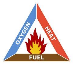
CDRP: Hazard Risk Analysis

Brush, Bush and Grass Fires Human-caused

   Hazard                                                                           Need More               Not
                                  High Risk                     Low Risk
   Rating                                                                              Info              Applicable

             Need More Info

                              Not Applicable
                                               FACTORS
  Yes

        No

                                               Brush or grass fires are more likely to occur again where they have happened
                                               in the past. Have brush/grass fires, caused or started by humans, happened
                                               previously in your community?
                                               The risk indicators for brush/grass fires are similar to wildfire. Does your
                                               community meet some or all of the wildfire risk factors? (Check the factors in
                                               the ‘Wildfire’ section below)
                                               Grass/brush fires can occur in the springtime before green-up and can
                                               contribute to spring cleanup fires becoming larger fires. Do you frequently have
                                               periods of hot dry weather in the early spring, before the new grasses have
                                               grown?
                                               Big areas of brush or standing dead grass are a fire risk. Are there large areas
                                               of standing dead grass in or around your community?
                                               Non-native grasses are a greater fire risk than native species. Do non-native
                                               grass species grow in or around your community?
                                               Scientists have observed that with increasing maximum summer temperatures
                                               there will be an increased chance of fires, and also more areas at high risk of
                                               fires. Has your community noted higher summer temperatures and has your
                                               community been identified to have been at high-risk of fires in the past?

Community Interface Fires Natural and Human-caused
Definition
A Community Interface Fire exists when there is uncontrolled burning in woodlands and the fire
(or smoke) may spread to nearby property, homes and infrastructure or threaten human lives.

Discussion
In many communities, residents have moved out of the central area of the community and pushed
out into wooded areas – often to appreciate the natural beauty of Canadian forests. Unfortunately,
not all businesses and homeowners are aware of the potential for forest fires or wildfires nearby,
and make sure to protect their buildings. Once fires start it may not be possible to prevent the
buildings from being destroyed.

The section on ‘’Forest Fires or Wildfires contains much of the same information that is also related
to community interface fires. The main difference is that it is not just the forests that are burned,
but also the homes and businesses of the community. Forest fire fighters fighting, community
interface fires need to know the best ways of dealing with structural fires, as well as forest fires.

                                                                                                               FIRES     3
CDRP: Hazard Risk Analysis
It Happened Here….
Between April and November 2017, more than 1,300 fires engulfed British Columbia, costing
more than $564 million and displacing 65,000 residents. Multiple air quality advisories were also
issued as a blanket of smoke covered parts of B.C. Most of the homes on the Ashcroft First
Nation reserve were lost, as were many of the homes in Boston, Flats. The city of Williams Lake
was evacuated as was 100 Mile House. The Plateau Fire was the result of 20 fires near Williams
Lake and covered 545,151 hectares. During peak activity, more than 4,700 personnel were on
the front lines, and more than 1,200 of the firefighters were from outside the province. Support
poured in from across Canada, as well as Australia, New Zealand, Mexico and the U.S. The
Canadian Armed Forces also provided support.
Three communities of the Ts’kw’aylaxw First Nation (near Kamloops, BC) were put on an
evacuation alert in May 2012, when a forest fire burnt close to their communities. The blaze was
thought to be human caused, and burnt about 140 hectares. Six planes, five helicopters and 41
fire fighters were needed to combat the fire in the steep, and hard to access, terrain.
During the summer of 2003, the McClure Lake fire, 35 kilometres north of Kamloops, forced the
evacuation of residents of Barriere, McClure and Louis Creek, along with the closure of a portion
of Highway 5 south to Kamloops. The fire destroyed 73 homes in Barriere and Louis Creek and
destroyed the Tolko sawmill, the region's biggest employer. It was caused by discarded cigarette.
4 FIRESCDRP: Hazard Risk Analysis
Community Interface Fires Natural and Human-caused
Hazard Need More Not
High Risk Low Risk
Rating Info Applicable
Need More Info
Not Applicable
FACTORS
Yes
No
Community interface fires are most likely to occur where they have happened
in the past. Have community interface fires happened in your community
before?
Community interface fires occur where homes or buildings exist in or next to
undeveloped wildlands. Are houses and buildings located in or next to forested
areas?
Is your community vulnerable to the risk factors for forest or wildfires? (see
Section on Forest Fires and Wildfires)
Fire can spread from homes to forest. Is your community lacking proper
structural firefighting capacity?
Fire can spread from forests to built-up areas. Is your community lacking proper
wildfire-fighting capacity?
Bylaws and building codes can reduce the chance of interface fire. Are bylaws
and building codes lacking enforcement in your community?
Building materials that easily burn, such as cedar shingles and plywood, can
increase the chance of fire. Is construction with flammable materials
encouraged?
A community protection plan and the FireSmart principles (see Risk Analysis
Resources) can decrease the chance of interface fire. Is your community
lacking compliance with FireSmart principles?
Community Structural Fires - Human-caused
Definition
A community structural fire is a fire which happens in a residential, commercial or industrial
community. Fires occur on a frequent basis in many parts of Canada. Fires of great concern, are
those that cause a large number of deaths or injuries, those that are beyond the ability of the local
resources to respond, or those that cause severe economic losses.
Discussion
Fires are classified in a number of ways: residential fires, schools, automobile fires, large dollar
loss fires and arson. Efforts to reduce fires through fire prevention initiatives and public safety
awareness, have not led to a lot less arson fires in Canada since 2005, when 13,315 cases were
reported.
FIRES 5CDRP: Hazard Risk Analysis
It Happened Here…
On May 2, 2019, a house fire claimed the lives of one mother and four of her children in
Kitchenuhmaykoosib Inninuwug, also known as Big Trout Lake First Nation.
On February 20, 2019, seven children, all members of a Syrian refugee family, died early
Tuesday in a fast-moving house fire described as Nova Scotia's deadliest blaze in recent
memory.
On March 30, 2016, nine people from one family, including three children, died from a house fire
on the northern Ontario community of Pikangikum First Nation.
In January 2014, two young boys lost their lives in a fire in Pelican Narrows, Saskatchewan. Their
house on the Peter Ballantyne Cree First Nation reserve burnt down after candles sparked a fire
in the attic space. The community faces many problems in fighting fires on the reserve. The only
fire truck of the community is in need of repair, and many houses do not have running water.
On March 28, 2001 the oldest hotel in Beaverdell burned to the ground. The fire was noticed at
about 2 a.m. and the intense heat took the building quickly as volunteer fire fighters fought the
blaze for over five hours trying to contain the blaze. The fire was so intense it cracked the
windows of buildings across the street. Local residents in the north end of town experienced a
loss of power during the blaze. Locals are devastated by the loss of the heritage building built in
1901which was a drawing card for Beaverdell. People stopped just to see the old hotel.
Community Structural Fires - Human-caused
Hazard Need More Not
High Risk Low Risk
Rating Info Applicable
Need More Info
Not Applicable
FACTORS
Yes
No
The possibility of spreading community or structural fire exists wherever human
structures have been built. Is your community lacking structural fire-fighting capabilities?
Is your community lacking fire hydrants in its commercial or industrial areas?
Buildings that comply with National Building Codes are safer than non-compliant
buildings. Are many structures non-compliant with building codes in your community?
Does your community have old, historic, wood-frame or ply-wood buildings?
Forest Fires or Wildfires
Definition
Forest fires are started by lightning or by humans (either by accident or on purpose). Wildfire is
the general term used to describe when there is uncontrolled burning in woodlands.
Discussion
In Canada, approximately 8,000 wildfires take place annually, burning an average area of 2.5
billion hectares. Fourty-five per cent of all fires in Canada are caused by lightning. Fires caused
6 FIRESCDRP: Hazard Risk Analysis
by lightning burn most of the 2.5 billion hectares. Since these fires are often in rural or remote
locations and do not threaten communities, they are left to burn.
In a nutshell, fires of all kinds require three main
‘ingredients’: fuel (wood or grass for example), heat and
oxygen.Fire professionals call this the ‘Fire Triangle’
because all three ingredients are needed for a fire to
burn. If one ingredient is removed the fire will collapse
(or die out), kind of like the removal of a leg on a three-
legged stool. .
• Fuel is the wood, grass or other vegetation.
• Heat is the initial spark that starts the fire,
usually coming from lightning or human actions,
intended or accidental.
Figure 1. Fire Triangle (Image:
www.wikipedia.org) • Oxygen comes from the air and is refilled by the
wind.
Firefighters want to remove one or more of the three
ingredients to douse an active fire. They can use water, foam or dirt to cut of the oxygen, or air
supply, to the fire. This also lowers the temperature of the materials on fire (forest, grass, etc.)
below the point of ignition. And firefighters can remove fuel (forest, grass, etc.) in advance, by
creating so-called ‘fire breaks’ or removing dead vegetation before it has a chance to burn.
The Canadian Forest Fire Behavior Prediction (FBP) System outlines a number of factors
which can be used when calculating forest fire risk and are summarized as:
• Fuel type and condition: certain fuel (forest, grass, twigs, leaves) such as dry conifer
burn more easily than leave-shedding forests. Forests that have a lot of dead vegetation,
or ‘forest litter’ are also more likely to burn, than forests that do not have this forest litter.
The amount of moisture (or water) within the soil, shrubs and trees is also very
important. Forest fire ratings are usually ‘high’ or ‘extreme’ when the forests are dry
(even when skies are overcast). Low water content happens especially after long dry
spells in late spring and/ or summer.
• Weather: weather has a great effect on wildfires. Unfortunately it can be very
unpredictable and we cannot control it. Long-lasting periods of no rain of course reduce
the amount of moisture (or water) within a forest, and thus boost the chance of wild fires.
However, winds greatly shape the spread and intensity of a wild fire. Winds can also
carry embers away from a wildfire, and start so-called ‘spot fires’ somewhere else. A wild
fire can rapidly grow in such a way.
• Topography: Mountain slopes that are South facing are usually warmer and drier, and
as such have a higher chance of burning. Vegetation on slopes that are facing the most
common wind direction is often also drier. In steep mountainous terrain winds often
move uphill during the day, and as such the winds make an easy path for the fire to
travel. The heat from the fires are also carried uphill by winds, and so pre-heats fuel
(forest, grass etc.) uphill.
While most forest fires are caused by lightning, a lot of fires however are caused by humans
through logging or lumbering activities, recreational activities, railroads, land clearing and bush
burning, construction and other industrial operations. In 2003 lightning strikes, human
carelessness, and arson all contributed to igniting nearly 2,500 fires, which burned more than
265,000 hectares (ha).Over 10,000 firefighters and support personnel were involved in the
dousing of the fires. The cost of the fires was estimated at $375million..
FIRES 7CDRP: Hazard Risk Analysis
Several tools are available for fire fighters, residents and tourists to assess the risk of wild fire.
You can find an overview of these tools in the ‘Risk Analysis Resources’ section.
It Happened Here…
In 2019, wildfires forced hundreds of people to evacuate from First Nations communities in
northern Manitoba and northwestern Ontario. The fires have also prompted special air quality
statements for parts of both provinces. Up to 150 residents from Little Grand Rapids and as many
as 50 residents from Pauingassi First Nation were evacuated. The Red Lake 23 wildfire burned
719 sq. km. and remained out of control, burning just eight kilometres south of Keewaywin First
Nation. About half of the community’s 450 residents fled for Sioux Lookout, Ont., and Timmins.
The military was called in to evacuate the community from the Pikangikum First Nation.
The 2019 wildfires in Alberta displaced approximately 20,000 people in more than 20
communities and burned more than 800,000 hectares. About half of the area burned this year has
been around High Level where the Chuckegg Creek wildfire had consumed 350,000 hectares of
land since it was discovered May 12.
The fires in 2018 burned more than 13,000 sq km. in British Columbia and eclipsed the fires in
2017 as being the worst ever. About 3,200 people have been removed because of the wildfires,
and another 21,800 were on alert, as 534 fires burned across the province; most caused by
lightning, but 443 by human activity.
A forest fire affected the community of Kleena Kleene, British Columbia (population 808) in June
2004. Residents and tourists were evacuated from the Lonesome Lake and Klinaklini fires in
South Tweedsmuir Park. The fire was caused by lightning and grew to 22,745.0 hectares.
On June 15 2009, one of the fires near Grayling Creek and Gregoire Tower, about 45 kilometres
south of Fort McMurray Alberta, closed part of Highway 63 to Fort McMurray. Traffic was
detoured to Highway 881, with traffic being redirected at the junctions of highways 63 and 881,
highways 55 and 63 and highways 55 and 36. Officials estimated the fire at over 2,000 hectares
in size.
8 FIRESCDRP: Hazard Risk Analysis
Forest Fires or Wildfires Natural
Hazard Need More Not
High Risk Low Risk
Rating Info Applicable
Need More Info
Not Applicable
FACTORS
Yes
No
Wildfire is likely to occur where it has happened in the past. Have wildfires
occurred in or near your community before?
Is your community located in or near forestlands, particularly coniferous (pine-
tree) forests?
A long history of fire prevention activities can increase the risk of wildfire, as
more fuel such as dead wood and brush will be on the forest floor. Is there a
history of wildfire prevention activities in or near your community?
Almost half of the wildfires in Canada are caused by lightning strikes. Is your
community in an area that has summertime thunderstorms?
Wildfire is most likely to occur during or immediately following long periods of
hot dry weather. Does your community experience regular heat waves and
minimal rainfall in the summer?
Winds cause fire to burn more intensely. Does your community experience high
winds during the summer?
FIRES 9CDRP: Hazard Risk Analysis
Forest Fires or Wildfires - Human-caused
Hazard Need More Not
High Risk Low Risk
Rating Info Applicable
Need More Info
Not Applicable
FACTORS
Yes
No
Wildfire is most likely to occur where it has happened in the past. Has your
community previously experienced wildfires caused by humans?
Is your community located in or near forestlands, particularly coniferous
forests?
A lengthy history of fire prevention can increase the risk of wildfire, as more fuel
such as dead wood and brush will be on the forest floor. Is there a history of
wildfire suppression in or near your community?
Wildfire is most likely to occur during or immediately following long periods of
hot dry weather and can contribute to small fire becoming larger ones. Does
your community experience regular heat waves and minimal rainfall in the
summer?
Prevention measures can reduce the risk of wildfire. Does your community lack
a fire-preparedness plan?
About half of all wildfires are started by humans or human activity. Do people
camp or use forested areas near your community? Does logging and/ or slash
burning occur near your community?
Scientists have observed that with increasing maximum summer temperatures
as a result of climate changes there will be an increased chance and more
areas at high risk of fires. Has your community noted increased summer
temperatures and has your community been identified to have been at high-risk
of fires in the past?
Peat Bog Fires
Definition
Peat bogs can dry out and catch fire (by natural causes or human activities). As the peat runs
deep into the earth, the fire can smolder beneath the ground for long periods of time. This creates
smoke hazards to surrounding populations.
Discussion
All wetlands can store large amounts of water. Peat bogs can also hold water, as the rotting plant
matter has small particles and does not easily drain. Wetland plants hold more water in their
roots, leaves and stems than dry land plants. Therefore in times of heavy rain, wetlands absorb
water, and by holding the water in the plant roots the chance and severity of flooding lessens.
However, when bogs do dry out (after periods of droughts) and catch fire, they are very hard to
smother as they can burn undetected under the ground for a long period of time, and suddenly
reach the surface.
10 FIRESCDRP: Hazard Risk Analysis
It Happened Here…
On June 19, 2020, two water bombers have been called in to help extinguish a fire that started in
the Lambert Bog, and then spread to the surrounding woodlands in the Kamouraska region.
Firefighters were having difficulty accessing the fire by ground as it burned between the towns of
Rivière-Ouelle and Saint-Denis-de-la-Bouteillerie, about 100 kilometres northeast of Quebec City.
On July 3 2016, a fire started at Burns Bog, burning over 78-hectares. Highway 17, a major
thoroughfare in the community south of Vancouver, was closed and an evacuation order was
issued affecting about a dozen businesses at the Tilbury Industrial Park. At one point, the fire
jumped the highway into the industrial area, which includes a forest products company and a
chemicals business. The fire was extinguished on July 11.
Burns Bog, near Vancouver, BC, is the largest peat dome on the west coast of North America. It
has traditionally been important to First Nation communities in the area, who used the plants in
the bog for medicinal uses. Burns Bog has experienced many fires in the past, one of the biggest
happened in September 2005, when 200 hectares were burnt. Smoke from the fire covered the
Lower Mainland of British Columbia, and was blown as far away as Nanaimo on Vancouver
Island.
In 2002, the Crow Lake Bog in Northern Alberta (> 100 ha) was extensively burned.
Peat Bog Fires - Natural
Hazard Need More Not
High Risk Low Risk
Rating Info Applicable
Need More Info
Not Applicable
FACTORS
Yes
No
Peat bog fires will occur again where they have happened in the past.
Canadian research shows that peat bogs happen again sometime between 4
and 102 years. Has there been a peat bog fire in the past?
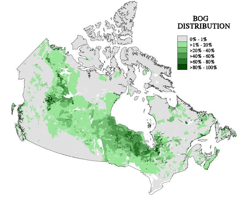
Is your community located in an area known to have peat bogs (Check Risk
Analysis Resources – Peat Bogs)?
Does your community experience hot dry summers?
FIRES 11CDRP: Hazard Risk Analysis
Peat Bog Fires Human-caused
Hazard Need More Not
High Risk Low Risk
Rating Info Applicable
Need More Info
Not Applicable
FACTORS
Yes
No
Are peat bogs frequented by tourists, hikers, or locals?
Is your community located in an area known to have peat bogs (Check Risk
Analysis Resources – Peat Bogs))?
Does your community experience hot dry summers?
12 FIRESCDRP: Hazard Risk Analysis
Risk Analysis Resources
Peat Bogs
Figure 2 Peat Bog Areas of Canada
FIRES 13CDRP: Hazard Risk Analysis Fire Related Resources FireSmart Canada provides resources for fire fighters, community members, industry and educators on topics related to wild fire, forest fire, wildland/ community (or urban) interface fire. Keywords: Fire Smart Canada, wild fire, forest fire, natural hazard Natural Resources Canada provides reports, guides, links, maps, and a web-based fire information system that monitors daily forest fire conditions and fire occurrences across Canada. It also provides information about wildfires, the Canadian Forest Fire Behaviour Prediction System and the Canadian Wildland Fire Information System. Keywords: Natural Resources Canada, forests, forest fires, wild fire, natural hazards Fire Prevention Canada provides links and useful tips regarding fires safety in general. Keywords: Fire Prevention Canada, forest fires Canadian Forest Fire Behavior Prediction (FBP) System The Institute for Catastrophic Loss Reduction (ICLR) has a lot of information about a number of natural hazards including wildfires. Keywords: Institute for Catastrophic Loss Reduction, wild fires, forest fires 14 FIRES
CDRP: Hazard Risk Analysis

References
Associated Press. (2019, February 20). Seven Syrian refugee children die in Canadian house
       fire. News.

Bonazuntas, M, Kallidromitou, D., Dassomenos, P.A., Passas, N. (2007). Forest fire risk analysis.
      Human and Ecological Risk Assessment, 11(3), 617-626.
      https://doi.org/10.1080/10807030590949717

Botanical Electronic News. (2004). Natural fire regimes in British Columbia and the summer of
       2003.

British Columbia Wildfire Service. BC wildfire service mandate & strategy.

Burns Bog Conservation Society. (n.d.). Protecting the lungs of the Lower Mainland since 1988.

Canadian Press. (2009, May 03). Several grass and bush fires burn north and south of
       Edmonton. CBC News

Canadian Press. (2016, July 5). B.C.’s Burns Bog fire 60 per cent contained, industrial park
       evacuation ends. CTV News.

Dantionio, C.M., Vitousek, P.M. (1992). Biological invasions by exotic grasses, the grass fire
        cycle, and global change. Annual Review of Ecology and Systematics, 23, 68-87.
        https://doi.org/10.1146/annurev.es.23.110192.000431

Dehaas, J. & Macdonell, B. (2019, July 7). Wildfires force hundreds to flee in Manitoba, Ontario.
       CTV News.

Dry conditions spark wildfires and fire bans in Alberta. (2009, June 15). CBC News.

Duran, E. (2017, December 25). B.C. year in review 2017: wildfires devastate the province like
       never before. Global News.

Government of Canada. (2015). Get prepared.

Granum Fire Department. (2014). Granum Fire Department.

Headwaters Economics. (2020, April). Land use planning can reduce wildfire risk to homes and
      communities.

Homeowner Protection Office. (2011). Homeowners and homebuyers.

Kennedy, G. (2017, July 6). “It’s not a dead zone”: Burns Bog fire one year later. Surrey Now-
      Leader.

Kornik, S. (2019, April 20). Brush fire in northeast Edmonton comes close to homes. Global
        News.

Lewis, S. (2012). Fire season starts off with a threat to First Nations. Aboriginal Multi Media
        Society.

Lindsay, B. (2018, August 29). 2018 now worst fire season on record as B.C. extends state of
        emergency. CBC News.

MSN Newsroom Staff. (2021, March 28). “Out of control” wildfire that caused evacuations in
      southern Alberta contained, alerts cancelled. MSN News.

                                                                                     FIRES        15
CDRP: Hazard Risk Analysis
Omstead, J. (2019, July 29). Massive wildfires displaced thousands, burned an area larger than
Banff National Park. CBC News.
Red Cross. (n.d.). Terrorism safety tips.
Staff and Agencies in Pikangikum. (2016, March 30). Nine dead in family house fire at remote
Canadian Indigenous community. The Guardian.
Statista. (2021, March 2). Crime in Canada – Statistics and facts.
Stewart, S., Radeloff, V.C., & Hammer, R.B. (2007). The wildland-urban interface in the United
States.
That smoky haze? Blame Canada. (2010, June 1). Boston Business Journal.
Walker, C. (2014, January 27). Fire safety on First Nations a national problem. CBC News.
Water bombers called in to fight forest fire burning in Kamouraska. (2020, June 19). CBC News.
Working Group II Contribution to the Fourth Assessment Report of the intergovernmental Panel.
(2007). Climate Change. 2007. Impacts, adaptation and vulnerability. L. Parry, O. F.
Canziani, J. P., Palutikof, P. J. van der Linden & E. E. Hanson, (Eds.). Cambridge
University Press.
16 FIRESYou can also read