History of Barker's Mill Darling Harbour (Extracted from Cross City Tunnel Archaeological Assessment)
←
→
Page content transcription
If your browser does not render page correctly, please read the page content below
History of Barker’s Mill

       Darling Harbour

(Extracted from Cross City Tunnel
   Archaeological Assessment)

            From report to

          CW-DC Pty Ltd

             on behalf of

           BHBB Pty Ltd

            September 2002
1

2.0     Historic Context

2.1     Barker’s Mill

Centred on Sydney Cove
When the first European settlers disposed of themselves and their goods around the shores of
Sydney Cove in 1788, the form of the new settlement was dictated by topography, social
distinctions and subsistence needs. As temporary arrangements crystallised into permanency,
the development of the settlement continued to be heavily influenced by the factors that had
dictated its earliest form. The town of Sydney faced and was focused on Sydney Cove, where
all overseas shipping, its lifeline to the outside world, berthed. On the west side of the cove,
the area appropriately known as The Rocks was soon well populated with a rich and diverse
mix of occupants and businesses typical of a seaport. At the mouth of the Tank Stream
merchants took advantage of access to the water frontage to construct their houses and business
premises, while on the east side of the cove successive governors improved their residence and
extended its grounds.

The pattern and purpose of the original settlement were clear. For the first thirty years of its
existence, New South Wales was a settlement whose primary function was as a penal colony.
Despite this intention trade, both at home and abroad, flourished. Access to boats, ships and
shipping, the potential means of escape from this ‘open prison’, was supposedly restricted and
regulated but the entrepreneurial spirit of the Colony’s early residents, bond, free and freed
challenged (and ignored) restriction. Agricultural endeavour soon moved from Farm Cove to
Parramatta and the Hawkesbury with a growing river trade to the Sydney market. By the early
1800s merchants engaged in overseas trade were building their own wharves, stores, counting
houses and residences. Sydney became a port of call for ships trading with China and India
and for American and British traders and whalers.

A major impediment to development was the restricted amount of wharfage at Sydney Cove.
In 1807 Governor Bligh redefined the Government Domain as the ‘domain of the Governor’s
residence’, reserving all of the east side of Sydney Cove as part of the grounds of Government
House. The claim was taken up and enlarged by his successor Governor Macquarie, leaving
no provision for the Colony’s new entrepreneurs and their commercial ambitions. On the west
side of the Cove two occupants dominated the waterfront, the government dockyard and
commissariat stores and the merchant Robert Campbell who had astutely leased land for his
private wharf, residence and extensive warehouses. On the south, the mouth of the Tank
Stream was rapidly silting up, destroying the commercial value of the older warehouses and
wharves. Cockle Bay, immediately to the west of Sydney Cove, was the obvious area of
expansion for Sydney’s maritime and commercial interests.

The development of Cockle Bay
By the Macquarie period the potential of Cockle Bay was being realised as merchants leased
large waterfront allotments and began to build wharves and warehouses.                 Governor
Macquarie’s General Orders of October 1810, giving substance (at least in name) to an
organised street plan for Sydney acknowledged the potential of the area and its role in Sydney’s
trade. The markets were to be relocated and a new wharf built in Cockle Bay ‘for the
Convenience of the Inhabitants in general, and particularly of those Persons bringing Corn or
other Grain, Goods or other Merchandize, in Vessels or Boats from the Hawkesbury, &c. to
the Market’. Associated with the new Market square and wharf was a new street, Market
Street that would now provide a direct connection between Cockle Bay and George Street, the
main artery of the town. Another new street, Sussex Street, immediately west of Kent Street

______________________________________________________________________________
Casey & Lowe                                       Cross City Tunnel Archaeological Assessment
2

and running parallel with it from the back of the barracks to the burying ground, extended the
town grid towards the shores of Cockle Bay.1

While commercial activity soon began to expand from Sydney Cove into the north end of
Cockle Bay around Miller’s Point, the southern end of the bay was not immediately attractive
to entrepreneurs. The only cross street connecting Cockle Bay with George Street was Market
Street and the area beyond the burying ground was, in effect, beyond the town proper. The
shallow waters at the head of the bay, needing long wharves to reach deep water, were a
further disadvantage. The area did however have other natural advantages, the most notable of
which were the springs of fresh water that drained into the head of Cockle Bay. It was here
that the first steam engine in Australia was to be put to work.

In October 1813 John Dickson arrived in Sydney bringing with him a considerable quantity of
goods and machinery, a steam-engine from his own manufactory in Southwark and men with
the skills to help to run his new enterprise.2 Amongst his apprentices was a young lad of about
fourteen called Thomas Barker.3 Dickson had been recommended to Macquarie by the
Colonial Office as ‘an excellent Engineer and Millwright’ and in recognition of his
‘Enterprizing Spirit and persevering Industry’, his considerable capital and in conformity with
instructions from London, Macquarie granted Dickson 15 acres of land at Cockle Bay for his
steam engine and 3,000 acres near Camden as a farm. The site chosen for the erection of the
steam engine was close to the waterfront at the head of Cockle Bay, to the west of Sussex
Street, an area amply supplied with water by the streams from the Brickfields and beyond. The
steam engine began operations in 1815 and powered a flour mill, the first use of steam power
in Australia.

By the time the first detailed survey of Sydney was carried out by William Harper in the early
1820s, Macquarie’s new Sussex Street extended, on paper at least, as far south as Goulburn
Street. In reality there were houses on the east side of Sussex Street from behind the barracks
to just south of Market Street. The line of Druitt Street was formed but not named, while
beyond it to the south there were large waterfront allotments but few buildings. The exception
was Dickson’s steam engine and its associated buildings, an impressive early industrial
complex with its own wharf.4

Cooper & Levey’s steam engine at Cockle Bay 1825-1828
Dickson’s supremacy in milling technology lasted until the mid-1820s when other merchants
and entrepreneurs also began to invest in industrial machinery. Raine and Ramsay imported
the second steam engine in April 1824 and in July 1825 the foundation stone was laid for John
Raine’s ‘Darling Mills’ at Parramatta where it was to be put to work.5 In the same month the
Lalla Rookh arrived in Sydney with a steam engine, and its engineer, for the firm of Cooper
and Levey.6 The 14-horse power engine ‘which excels its predecessors by nearly double the
power’ was to be put to work at Cockle Bay, below the old burial ground ‘with as little delay
as possible’. The engine would be used ‘solely for public accommodation’, injecting some
hope of competition into the lucrative milling business. The site chosen was to the north of

1
  Sydney Gazette, 6 October 1810, p.1.
2
  Sydney Gazette, 17 June 1815, p.2a. A Mr Griffiths who accompanied Dickson and who would appear
to have been his engineer died two months after his arrival in Sydney.
3
  Australian Dictionary of Biography, Vol 1 Entries for John Dickson and Thomas Barker.
4
  Harper’s Survey of Sydney c.1823, SZ 435 (State Records NSW).
5
  Sydney Gazette, 1 April 1824, p.2b and J.K.S. Houison: ‘The Darling Mills Parramatta’, Journal &
Proceedings Parramatta & District Historical Society, Vol 3 (1926), pp.126-127.
6
  Sydney Gazette, 12 May 1825, p.3 and 7 July 1825, p.2c.

______________________________________________________________________________
Casey & Lowe                                        Cross City Tunnel Archaeological Assessment
3

Dickson’s, utilising both the water frontage for wharfage and the natural water supply to feed a
reservoir for the boilers.7

In October as the firm was ‘actively employed erecting an exclusive building for the operation
of a steam mill to grind wheat’, the Sydney Gazette, commented upon recent ‘astonishing
improvements’ made around the shore at Cockle Bay.8 Conspicuous amongst these was ‘an
edifice belonging to Cooper & Levy of the Waterloo Company’, while Mr Dickson was also
adding to his ‘ponderous pile of structures’, perhaps in response to impending competition.9
By the end of December 1825 Cooper & Levey’s steam engine was at work. As the power of
the steam engine was great and it was ‘their determination to sell Flour at a small Profit’, its
customers were urged to keep it fully operational.10 By 1826 the firm had a large wharf at
Cockle Bay near the steam engine and had also built a five-storey grain store.11

Thomas Barker’s interests at Cockle Bay 1824-1830s
At about the same time as Cooper & Levey were expanding their interests at Cockle Bay, John
Dickson’s former apprentice and now his clerk, Thomas Barker, was beginning his move
towards independence. In June 1823 Barker had married Joanna, the daughter of James and
Helen Dickson of Bringelly and niece of his employer. The following year he successfully
addressed a memorial to the Governor asking for an allotment of land on which to build a
house.12 His choice of site, at the south-west corner of Sussex Street and Bathurst Street, did
not take him far from his work at Dickson’s steam engine and it was here that he built his first
home with a frontage to Sussex Street.13

In 1826 Thomas Barker went into business on his own account in partnership with John Smith
and built a windmill at Darlinghurst, then known as Elizabeth Point.14 The partnership was a
brief one, but Barker’s activities as a miller, a trade in which it was possible to make
considerable profits, prospered. In 1827 he was sufficiently affluent and confident in his own
abilities to purchase Cooper and Levey’s steam mill adjacent to his home in Sussex Street. The
price for the ‘capital building and steam engine with other machinery and apparatus for the
purpose of grinding corn’ was £6,000, with a mortgage of £5,000 to Cooper & Levey.15

By the time the census was taken in 1828 Barker was a substantial employer. His enterprise in
Sussex Street, including his domestic servants, consisted of: John Dickson superintendent;
Alexander Dyers millwright; Joseph Kendall clerk; William Lowe engineer; Dennis Murray
cook; George Payne groom; Charles Bones and James Burbridge millers; James Browne
gardener; seven labourers; two carters; two housemaids and a waterman. The Dickson
connection, now a family one, continued. Charles Henry Jenkins of the Customs Department

7
  G.F.J. Bergman: ‘Solomon Levey in Sydney. From Convict to Merchant Prince’, Journal of the Royal
Australian Historical Society, Vol 49 Pt 6, March 1964, p.407.
8
  The erection of the mill was mentioned by Solomon Levey in his petition for a land grant, quoted in
G.F.J. Bergman: ‘Solomon Levey in Sydney. From Convict to Merchant Prince’, Journal of the Royal
Australian Historical Society, Vol 49 Pt 6, March 1964, p.410.
9
  Sydney Gazette, 6 October 1825, p.2d.
10
   Sydney Gazette, 19 December 1825, p.1d.
11
   G.F.J. Bergman: ‘Solomon Levey in Sydney. From Convict to Merchant Prince’, Journal of the Royal
Australian Historical Society, Vol 49 Pt 6, March 1964, p.407.
12
   Colonial Secretary’s correspondence: Memorials, T. Barker 4/1836A No. 32, pp.147-152 and
Colonial Secretary Letters sent within the Colony 4/3510, p.656, Reel 6012 (State Records NSW).
13
   A.K. Weatherburn: Thomas Barker Pioneer Australian Industrialist (1799 to 1875), Privately
published 1985, Map No. 1.
14
   Sydney Gazette, 2 June 1825, p.3 and 1 November 1826, p.3b.
15
   Bk 11 No 420, Conveyance dated 16 June 1827 (Land & Property Information) and Norton Smith &
Co. documents: Barker papers A 5398 / 3, Schedule of deeds 14 March 1851 (Mitchell Library).

______________________________________________________________________________
Casey & Lowe                                          Cross City Tunnel Archaeological Assessment
4
and Richard Baylis also lived at Barker’s address.16 Barker had, it seems, obtained not only the
steam engine but also the services of its engineer, William Lowe who had arrived on board the
Lalla Rookh with his family, on a five year contract with Cooper & Levey.17 In 1829 Barker
purchased the land immediately adjacent to his own to the west, with a frontage to Bathurst
Street and Cockle Bay, originally granted to Ramsay and Raine and in 1831 consolidated his
original lease and two purchases into one land grant of over 6 acres. Within five years of
setting up in business on his own account he had acquired substantial premises and land in
Sydney and at Darlinghurst. Within ten he would have enough to retire.18
Darling Harbour from the late 1820s - early 1850s
From the late Macquarie period and into the early 1830s, New South Wales was in a period of
transition and growth. Private enterprise and free settlement were growing forces. With the
influx of free settlers from the later 1820s and a shift from convict to free labour, larger
players came into prominence and the move to Cockle Bay gained momentum. As the
population of the Colony and of Sydney doubled between 1828 and 1836, imports of all kinds
were needed to feed consumer demand. On the other side of the ledger was the growing
business of export, as the Colony began to produce goods with overseas markets. In 1828
Cockle Bay took on a new name and was officially recognised as Darling Harbour.19 Shell
gathering to provide building lime was now a thing of the past.
By 1836 the town of Sydney extended as far south as Campbell Street. The main axis of the
town was predominantly north-south but now Druitt Street, Bathurst Street and Liverpool Street
all extended down to the waterfront at Darling Harbour, serving the wharves and mills. Along
Sussex Street occupation now stretched from Erskine Street to Bathurst Street, with the
southern end dominated by steam engines and mills.20
The rapid development of the area was summarised in 1839 by James Maclehose:
For many years the shores of Darling Harbour, on the western side of Sussex Street,
were regarded as land of little or no value: but no sooner had Sydney begun to rise in
importance as a commercial town, than the land in this vicinity had its value
discovered, and almost the whole of the water frontage was secured by men of capital,
who have of late years further enhanced its value by the erection of substantial and
extensive warehouses, stores, and other buildings, which their increasing mercantile
transactions have rendered necessary.
Sussex Street was ‘the main thoroughfare between the wharfs, warehouses, flour mills,
shipbuilding yards, and manufactories’ on the east side of Darling Harbour ‘and perhaps for its
length, has more valuable merchandise and other property conveyed through it than any other
street in Sydney.’ Its buildings included ‘not less than eight flour mills, belonging to the first
merchants in the colony’ all actively at work, as well as the patent slip and more than a dozen
large wharfs, ship and boat building yards.21
16
M.R. Sainty & K.A. Johnson (eds.): Census of New South Wales November 1828 (1980).
17
Sydney Gazette, 7 July 1825, p.2c. William Lowe is listed as ‘engineer to D. Cooper’ in the 1825
Muster, see C.J. Baxter (ed.): General Muster List of New South Wales 1823, 1824, 1825 (1999), Nos.
30123-30126.
18
‘Law Intelligence’, Sydney Morning Herald, 1 April 1848, Supplement p.1b.
19
Sydney Gazette, 4 July 1828 and 7 August 1828.
20
Map of the Town of Sydney 1836. Drawn and engraved for the proprietor W.G. Caporn, New South
Wales Calendar and General Post Office Directory 1836.
21
James Maclehose: Picture of Sydney and Strangers’ Guide in new South Wales for 1839 (1977 edition),
pp.61-62.
______________________________________________________________________________
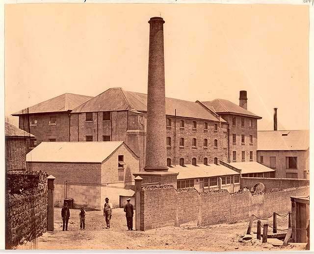
Casey & Lowe Cross City Tunnel Archaeological Assessment5 By the early 1840s another industrial enterprise, the new Gas Works, had been added while on the west side of Darling Harbour development was limited to the north end at Pyrmont, with the rest of the peninsula, the Ultimo Estate, still in private hands. The economic depression of the 1840s was particularly disastrous for those with large investments in wool, but in the closely interconnected world of business finance, a ‘domino’ effect was inevitable as soon as some began to fall. The less astute disappeared from the scene whilst others, many of whom thought they had made their fortunes, had to go back to work. Barker’s steam engine and mill 1827-1834 The late 1820s and early 1830s were a period of growth not only for Sydney but also for Thomas Barker. The mainstays of his prosperity were his steam flour mill and his investments and sales in land. Although Cooper & Levey’s mill was obviously impressive by contemporary standards, no description of it is known and Barker’s additions and improvements to the property have to be determined from a variety of sources, including surveys, illustrations, photographs and legal documents. In August 1828 Barker asked the Town Surveyor to measure his ground on Sussex Street, a request that was fulfilled within a few days. The resulting survey was very basic (Fig. 3.2) but included the outline of the steam mill, a second building on the mill land close to Sussex Street and two buildings on Barker’s original lease at the corner of Bathurst and Sussex Streets.22 A survey of Ramsay’s land by Assistant Surveyor Thompson a year later (Fig. 3.1) also showed the mill, in outline.23 Both surveys indicate that the mill was a large, rectangular building with its long axis east-west, located close to the boundary between Cooper & Levey’s property and Barker’s lease. If the dimensions of these plans can be relied upon, then the ratio of the length of the mill to its width suggests that, by 1828, the building comprised the two main sections that are clearly visible in later illustrations and photographs. A detailed survey of the site, drawn by Ambrose Hallen in his capacity as Town Surveyor (an office he held from December 1827 to 31 March 1832) shows a somewhat different outline (Fig. 3.3). Hallen’s field book is undated but it seems likely that his sketch of Barker’s premises was drawn between 1828 and 1830, when his survey of this section of the town was completed.24 Hallen’s sketches show that the main building was comprised of two rectangular sections, immediately adjacent to each other, with smaller buildings at both ends of the northern half. The small building at the east end probably housed the boilers, as it included a chimney. According to Hallen’s dimensions (given in links) the main building was some 95 feet long, with the northern section approximately 26 feet wide and the southern slightly larger at about 30 feet. This is confirmed in later legal documents (Fig. 3.11) which refer to this part of the mill complex as the ‘old mill’.25 Later images show that the two main parts of the mill, both built of stone, were of different design and quality of finish. The stonework of the northern section, which had round-headed windows and a gable roof, was much less finely finished than that of the southern half, which had a hipped roof of lower pitch and square window openings.26 Both buildings had cellars, giving a total of five floors in each.27 22 Surveyor General’s Sketch Books, Vol 1 Fol 27 by T. Florance dated 26 Aug 1828, X750A, Reel 2778 (State Records NSW). 23 Surveyor General’s Sketch Books, Vol 1 Fol 43, X 750A, Reel 2778 (State Records NSW). 24 Surveyors’ Field Books No. 347, A Hallen, 2/5195, Reel 2628 (State Records NSW). 25 Conveyance dated 1868 Bk 112 No 140 (Land & Property Information). 26 Photograph of the mills c. late 1860s, SPF/484 (Mitchell Library). 27 Lease dated 1 April 1864, with Claim No. 1080, Day Street resumptions (Sydney City Council Archives). ______________________________________________________________________________ Casey & Lowe Cross City Tunnel Archaeological Assessment
6

It is possible that the second structure, alongside the first, was built by Thomas Barker soon
after he had purchased the mill from Cooper & Levey in 1827 and that improvements or
additions were also made to the arrangements of the boilers and engine at the same time.28
Norman Selfe, writing in 1900, stated that Thomas Barker had erected two new flour mills
alongside his original one, of which this could have been the first.29 Alternatively the second
structure may have been Cooper & Levey’s grain store, built in 1826 and designed, like the
mill, with five floors, an obvious addition for a successful flour mill.30

By about 1830 the main elements of Barker’s property were the two large stone buildings,
steam engine and boilers, two mill ponds, fed by a stream running from the east under Sussex
Street and some smaller buildings close to the southern boundary. On the Sussex Street
frontage there were three buildings as shown in Florance’s survey in 1828 (Fig. 3.2). A stone
wall across the yard on the north side of the mill may have defined the western boundary of
Barker’s original lease at the corner of Bathurst and Sussex Street. The entrance to the mill
was on the Sussex Street frontage between Barker’s residence on the north side of the gate and
the building to the south, which was also a residence. Much of the area, including the Bathurst
Street frontage, was unoccupied and the shoreline still had much of its natural configuration.

With increased development around the shores of Darling Harbour, Barker also profited from
the sale of some of his unused water frontage. Much of it was reclaimed land, an added bonus
for the owners of waterside property. By 1833 over seven acres had been sold, much of it to
four main purchasers. The owners of the largest portion were Hugh Brodie and Alexander
Craig, skilled migrants who had begun their working lives in Sydney as jobbing labourers on
the construction of Barker’s residence, Roslyn Hall. Now working in their own right as
builders and timber merchants, a site of over four acres at the end of Bathurst Street proved an
ideal location for their wharf and yards.31 On the next allotment was a sugar mill, another
addition to the processing industries typical of this part of Darling Harbour.32

Barker & Hallen 1834-1840
In 1833 Thomas Barker purchased land at Darling Point where he built a fine mansion, Roslyn
Hall, designed by one of the Hallen family.33 The location was one of social pre-eminence but
was also close to the windmills that had been the beginning of his fortune. By 1834 ‘having
what he considered a competence’ Thomas Barker decided to retire. The Sussex Street flour
mill (comprising steam engine, mill, granary, warehouses, coach houses, stables, out buildings,
yard and apparatus), together with the windmill at Woolloomooloo, were leased for fourteen
years to his brother James, in partnership with Ambrose Hallen, whose career as Colonial
Architect was rapidly coming to an end. The rental for the two properties was £1,200 a year.34
Thomas advanced James some money to assist with the new partnership and left £5,000 in the

28
   A.K. Weatherburn: Thomas Barker Pioneer Australian Industrialist (1799 to 1875), Privately
published 1985.
29
   N. Selfe: Annual Address to Engineering Section of the Royal Society of NSW 20 June 1900, Journal
& Proceedings of the Royal Society of New South Wales for 1900, Vol XXIV (1900), p.XXII.
30
   G.F.J. Bergman: ‘Solomon Levey in Sydney. From Convict to Merchant Prince’, Journal of the Royal
Australian Historical Society, Vol 49 Pt 6, March 1964, p.407.
31
   Barrie Dyster: Servant & Master. Building and Running the Grand Houses of Sydney 1788-1850
(1989), p.125.
32
   Report by E.J.H. Knapp dated June 1833 on quit rent payable on portions of Barker’s grant that had
already been sold, Barker Papers P21 Series 1 (University of Sydney Archives).
33
   James Broadbent: The Australian Colonial House. Architecture and Society in New South Wales 1788-
1842 (1997), pp.211-213.
34
   Lease dated 31 December 1834, Book G 911 (Land & Property Information).

______________________________________________________________________________
Casey & Lowe                                          Cross City Tunnel Archaeological Assessment
7

business.35 In the boom times of the 1830s, it seemed unlikely that the venture could fail and
with it Thomas Barker’s own financial future seemed assured.

In 1837 Barker and his wife went on a long trip overseas, visiting China, the Cape of Good
Hope, England and the continent. Further sales of vacant land around the mill were
contemplated, left in trust to Barker & Hallen with power to sell.36 In November Mr Polack
advertised that he had been instructed to auction 83 allotments ‘in Sussex, Bathurst, and other
streets, Sydney, the Property of Thomas Barker Esq.’, suggesting that a plan of subdivision had
been prepared.37

While Thomas Barker later stated that he played no part in the affairs of the firm of Barker &
Hallen, changes were made to the mill during the period of the lease sufficient to justify an
increase in rent to £2,000 per year. The size of this increase suggests that these changes were
additions and improvements to the buildings and machinery. As capital improvements of
substantial benefit to the owner, it seems likely that these were approved and funded by
Thomas Barker. A comparison of Hallen’s survey of the site and illustrations of the buildings
when under the management of Barker & Hallen, suggests that these ‘improvements’ took the
form of a substantial addition to the mill buildings. This consisted of a large five storey stone
building at the west end of the original mill, three bays long by four bays wide, together with a
new steam engine, boiler house and chimney. It was, in fact, another mill with its own steam
engine and boiler house and could be worked independently of the original. In later
documentation the two parts of the premises were differentiated by their owner as the ‘old
mill’, the two 1820s buildings and the ‘new mill’, the 1830s addition.

The additions are shown in illustrations of the premises drawn by J. Carmichael for bill heads
for the firm of Barker & Hallen. Two versions of the illustration exist, both showing the mill
viewed from the Sussex Street entrance, with the wharf in the distance. The earlier of the two,
in use in June 1837, shows the old mill and the addition as if they formed a single building, the
only distinction between the two parts being that the verandah did not extend along the whole
of the north side (Fig. 2.1).38 In the later version, in use in 1840, a truer picture is given.39
The addition at the west end is clearly distinguishable from the old mill, is slightly higher and
has different fenestration. The dates the two different versions of the Carmichael drawings
were in use and the increase in rent during the term of Barker & Hallen’s lease, suggest that
these additions were built in the later 1830s. Brodie & Craig could well have been the
builders.

35
   ‘Law Intelligence’, Sydney Morning Herald, 1 April 1848, Supplement.
36
   Lease & conveyance in trust dated 7-8 August 1837, Bk M 17 (Land & Property Information).
37
   The Australian, 7 November 1837, p.3e.
38
   G.K. Mann papers Vol.2, A2496 (Mitchell Library), reproduced in A.K. Weatherburn, 1985, Plate 6.
39
   Invoices and receipts 1836-1897, MSS 3960, No. 11 (Mitchell Library).

______________________________________________________________________________
Casey & Lowe                                         Cross City Tunnel Archaeological Assessment
8

Fig. 2.1: Bill head for Barker & Hallen, in use in 1837, ML A2496.

The collapse of Barker & Hallen 1840-1842
On his return to Sydney in September 1840 Thomas Barker found the affairs of the Colony
very different from those on his departure three years earlier. With a downturn in economic
activity in the late 1830s and drought conditions, wheat became scarce. In 1839 the colony was
importing flour but a year later locally grown wheat was plentiful, causing violent price
fluctuations and much reduced margins for millers. Barker & Hallen, who had entered into
fixed price contracts for the supply of flour, paid for in advance, were compelled to honour
these agreements as the price of wheat rose.40 While Thomas was still on board ship on his
arrival back in Sydney, James applied to him for money and was advanced £11,000 to help the
firm. The partnership with Ambrose Hallen was dissolved a week later but by October the
firm’s credit was no longer good. In November Barker & Hallen were insolvent.41

The collapse of Barker & Hallen, and hence of his own investments, brought Thomas Barker
out of retirement and back into business. The firm was put in the hands of trustees in an
attempt to trade its way out of insolvency and Thomas once again took over the business of the
mills.42 In 1842 an arrangement was made with the creditors for the sale of all of James Barker
and Ambrose Hallen’s assets to Donald Larnach, for just over £25,000.43 The arrangement,
‘not a mere winding up’ selling off old stock but ‘a purchasing of new stock, for the benefit of
the creditors’ 44 attracted criticism in the press, countered by an action for libel by one of the
trustees, John Lamb. The jury clearly had a poor opinion of it, and awarded the plaintiff a
farthing in damages. Donald Larnach later commented that the purchase was one ‘we have had
much cause to regret’.45 As the owner of the Sussex Street property, Thomas Barker was a

40
   G.J.R. Linge: Industrial Awakening. A geography of Australian manufacturing 1788 to 1890 (1979),
pp.92-95.
41
   ‘Law Intelligence’, Sydney Morning Herald, 1 April 1848, Supplement.
42
   James Barker and Ambrose Hallen, release of all real and personal estate to trustees, December 1840
and August 1841, Norton Smith & Co. documents: Barker papers A 5398 / 2, Item 12 (Mitchell
Library).
43
   Norton Smith & Co. documents: Barker papers A 5398 / 2, Item 14. Sale to Donald Larnach dated 26
July 1842 (Mitchell Library).
44
   Evidence by Donald Larnach, ‘Law Intelligence’, Sydney Morning Herald, 1 April 1848, Supplement.
45
   The Australian, 19 January 1841, Leader p.2 a-c and 10 June 1841, p.2c-f, Report of proceedings in
Supreme Court – Civil side.

______________________________________________________________________________
Casey & Lowe                                           Cross City Tunnel Archaeological Assessment
9

major beneficiary of this agreement and retained his real estate and the mills.46 Three months
after Larnach had rescued Barker & Hallen, he went into partnership with Thomas Barker,
trading as Thomas Barker & Co.47 For the Barker family, economies were made on the
domestic front and Roslyn Hall was temporarily given up for smaller premises. At the same
time attempts were made to sell parts of the Sussex Street site.

Residential subdivision in the 1840s
The proposed subdivision of Barker’s Sussex Street property retained sufficient working area
for the mills while maximising the sale potential of the rest, which was divided into 108
building lots (Fig. 3.4). Some had frontages to Bathurst and Sussex streets while to the west of
the mill, now enclosed by a stone wall, new streets were laid out, appropriately named Steam
Mill Street, Thomas Street and Barker Street.48 For any potential occupants of these
allotments, their lives would be dominated by the sounds and smells of the mills.

In the economic climate of the early 1840s attempts to sell larger properties were rarely
successful. Even the allotments on the main street frontages, Sussex Street and Bathurst Street,
took some time to sell and were still on offer in 1844 and in 1847. Mr Stubbs, the auctioneer
in 1844, tried hard to promote a sale. Sussex Street he noted ‘is the very street north and south
to the harbour; and since no street can possibly intervene to take any custom away, all the
waterside and shipping business and traffic influences that street to such a degree that it may be
termed the Thames-street of Sydney’. Bathurst Street too was a noble one, ‘the great leading
street east and west from the Park and Woolloomooloo’. With disarming honesty his
advertisement mentioned the presence of the slaughterhouse at the end of the street, the ‘speedy
removal’ of which ‘(now contemplated) will immediately raise the value of the property, and
increase the comfort of the neighbourhood’.49 In reality it seems to have remained something
of a deterrent.

In 1845 there was no mention of any of Mr Barker’s streets in the Council assessment books.
One small group of houses bore his name - nine timber and brick single storey residences with
only one or two rooms in ‘Barker’s lane’.50 These had been built not on the designated street
frontages of the subdivision but along the back lane to Bathurst Street, closest to the laneway
leading from the main street. Four were owned by Thomas Barker, but the others had new
owners including the local publican.51

Diversification in the 1840s: flour and tweed
In the mid-1840s a major change was made at the Sussex Street mills when Thomas Barker &
Co diversified into the manufacture of colonial tweed. From 1845 to 1847, as the venture was
put into effect, Barker went into partnership with John Walker, who had the practical
experience in cloth manufacture he lacked. Barker used his cousin in Scotland, James Duncan,
as a contact for the purchase of equipment and by June 1846 machinery from Taylor &
Wordsworth of York was ready to be shipped to Sydney. At the same time, part of the Sussex
Street premises were converted into a cloth manufactory, a change that necessitated
rearrangements in the flour mill, which had previously occupied all of the buildings.

46
   Bk 9 No 418 conveyance to Thomas Barker dated 1 July 1842 (Land & Property Information).
47
   Joseph Harding: Barker’s Mill (from “History of Textile Manufacture in New South Wales”) p.3.
48
   ‘108 allotments the property of T Barker Esquire ..’, E.J.H. Knapp, Subdivision plans 811.1733/94
(Mitchell Library).
49
   Sydney Morning Herald, 21 August 1844, p.4f.
50
   Rate Assessment Book, Phillip Ward 1845, Nos. 651-659 (Sydney City Council Archives). The lane
may previously have been called Sussex Lane. A number of the occupants listed in Barker’s Lane 1845
were living in Sussex Lane according to Low’s 1844 City of Sydney Directory.
51
   William Oliver, publican of the ‘Sir Walter Scott’.

______________________________________________________________________________
Casey & Lowe                                          Cross City Tunnel Archaeological Assessment
10

The 1842 subdivision plan provides some detail of the mill buildings before this change took
place (Fig. 3.4).52 When operating as a single enterprise, the main building (the ‘old’ and
‘new’ mills) housed the mills, granaries, flour warehouse and steam engine with the boilers in
separate building to the west of the new mill and to the north-east of the old mill. On the north
side of the yard there were the house, offices, stables, coach house and shed, bake house and
ovens while in the south-east corner of the mill yard was an L-shaped building (just visible in
Carmichael’s illustrations) identified, probably in error on the subdivision plan, as the ‘men’s
house’, but more likely to be the mess house.53

In this first stage of the change over to dual occupancy, the tweed factory was established in the
south-east corner of the site and the machinery was set up in the southern part of the old mill
and in the former mess house. Additional window openings and other changes may have been
required in the old mill, while in the mess house more light was provided for the weavers by
the addition of skylights. Associated with these buildings was the use of land that had been
intended to be residential allotments along the new James Street, a sure sign that the
subdivision sale had not been successful. On 1 January 1847 Thomas Barker leased the tweed
mill to John Walker for five years and shortly afterwards dissolved their partnership.54 The
lease shows the division of the old mill to accommodate the cloth factory, in plan and in section
(Fig. 3.6 & Fig. 3.7). The flour mill and tweed manufactory shared the same entrance on
Sussex Street and also the exits from the site on the west side towards the wharf.

Walker’s lease itemised the parts of the Sussex Street property he was to occupy: the woollen
spinning mill and cloth factory, dye house, warehouse and stores with yard. Barker was to
keep the steam engine that drove the machinery in good repair and retained the use of some
parts of the ground and first floors and the whole of second floor of the mill, a clear indication
that the two parts of the establishment were not independent of each other at this date.55 An
1847 sale plan for allotments on Sussex Street has a naïve, but informative sketch of the mills
in their new form, as seen from the Sussex Street side (Cover illustration). The northern half
of the old mill is identified by signage on the end wall as ‘Barker’s Steam Flour Mills’ while
the former mess house, now used in part as the weaving house, is identified as ‘Walker’s
Tweed Cloth manufactory’.56

By 1848 further buildings had been added to the cloth manufactory. These included a fulling
house and press house against the south wall of the old mill and a smithy (or workshop) and
dyehouse further to the south. An undated plan of the premises shows these additions (Fig.
3.5).57 The 1848 rate assessment listed the full complement of John Walker’s premises as:

        Factory, cording room, press room and weaving house, all of stone, fulling house and
        counting house & store of brick and the workshop & dyeing house of timber.58

52
   108 allotments the property of T. Barker Esquire ..,1842 by E.J.H. Knapp, Subdivision Plan Z SP
811.1733/94 (Mitchell Library).
53
   Barker & Hallen’s 1834 lease included ‘the present Messe or dwelling house’ on the north side of the
entrance to the mills. Presumably by the 1840s separate provision had been made for this function.
54
   A.K. Weatherburn: Thomas Barker … (1985), pp.92-93.
55
   Lease to John Walker dated 1 January 1847, Bk 13 No 316 (Land & Property Information, NSW).
56
   Allotments in Sussex Street adjoining Barker’s Steam Flour Mills and Walker’s Tweed Manufactory
1847, Map Z M2 811.1733/1847/1 (Mitchell Library).
57
   Barker Papers P21 Series 1 (University of Sydney Archives).
58
   Rate Assessment Book, Phillip Ward 1848, Nos. 2061-2067 (Sydney City Council Archives).

______________________________________________________________________________
Casey & Lowe                                            Cross City Tunnel Archaeological Assessment
11 Little is known of the changes made at this period to the flour mill, although these must have been quite extensive as a substantial part of the old mill was given over to new uses. It is possible that the loss of space was compensated for by greater efficiency through new machinery. Late in 1846 as parts of the building were being converted for use as the tweed factory, Barker imported and installed new flour-dressing machinery. In 1848 when his partnership with Donald Larnach ended and as John Walker took over the operation of the tweed mill, Barker went into partnership operating the flour mill with his brother James. Seeking new markets, he established an agency for the sale of his flour in the Moreton Bay district.59 Darling Harbour from the 1850s to the 1890s The gold discoveries of the early 1850s gave the Australian colonies new status as part of the British Empire and coincided with changes in technology, transport and communications that heralded a real break with the past. The importance of wool as the Colony’s main export, and a decline in the use of older commodities such as whale oil, saw a move towards specialisation on the wharves, while new types of shipping needed new facilities. Larger warehouses and stores were constructed and parts of the foreshore were reclaimed, as wharves were pushed out further from the shoreline. The rush to the gold fields in the early 1850s temporarily paralysed city life and caused massive economic disruption as wages, rents and the prices of all commodities rose. By the time things returned to normal, commerce and technology had entered a new age. By the mid-1850s the east side of Darling Harbour was assuming a new form as the shoreline was reclaimed and new wharves proliferated. Improvements at the wharves did not however negate the steep climb from the shore up to George Street, the city’s main artery. The problem of conveying goods to and from the wharves at Darling Harbour was to be a major issue of city planning for some 150 years. Two new features made their appearance at Darling Harbour in the later-1850s. The first was the railway and the second, Pyrmont Bridge.60 The major technological development of the 1850s in New South Wales was the railway, a boon to individual travellers but, more importantly, the means by which the colony’s primary produce could be brought to the wharves for shipment overseas and to other colonies. To ship wool, the colony’s main export, the new larger steam ships required deep water wharves, specialised wool stores and lifting equipment. The natural configuration of the Darling Harbour shoreline made the easy transfer of goods from drays to ships almost impossible and increased development around its shores was causing the head of the harbour to silt up. The decision to build the first railway line from Sydney to Granville and beyond helped to solve both of these problems. In order to fulfil its potential for the transport of primary produce, a branch line was constructed to the west side of Darling Harbour and opened in September 1855, the first direct link between the railway and shipping. Fill from the excavation of the Sydney railway yards was used to reclaim land upon which part of the goods yards were built, making constructive use of already silted areas. By 1865 a stone dyke linked the reclaimed area at the end of Darling Harbour with the end of Dickson’s old wharf, which had once been a long finger projecting into the head of Cockle Bay. Continuing development of the railway yards and associated wharfage in the 1870s and 1880s saw the completion of a semi-circular iron wharf to meet the needs of larger steam ships and the construction of a 59 A.K. Weatherburn: Thomas Barker … (1985), pp.86-87. 60 Public Works Department of NSW: ‘Conservation Study. Darling Harbour Bi-Centennial Development Project: a brief history of its evolution and an assessment of the cultural significance of the items of the built environment in the area’ [nd], Historical research by Terry Kass. ______________________________________________________________________________ Casey & Lowe Cross City Tunnel Archaeological Assessment
12

railway siding on the west side of Darling Harbour, parallel with Harris Street. From the
1870s the Darling Harbour goods yards became the centre of the railway freight network
serving much of Sydney’s cargo shipping, while Circular Quay was used by the harbour ferries
and some of the large overseas shipping lines.

Industrial expansion around Darling Harbour from the 1850s included both the older
established manufactories like flour mills, as well as those companies whose work was
associated with the railways, such as P.N. Russell & Co. and Atlas Engineering which built
rolling stock. By the 1880s there was discussion about extending the railway along the east
side of Darling Harbour towards Circular Quay but a combination of political factors and
divergent views as to the route, combined to ensure that the proposal did not succeed. Instead
the facilities at the goods yards continued to be improved and together with their associated
wharfage eventually extended along the whole of the west side of Darling Harbour as far as
Pyrmont Bridge.

Communication across Darling Harbour, providing a direct route from the west side of the city
at the foot of Market Street to the developing suburb of Pyrmont, became possible in 1857
when a timber toll bridge was opened. An opening span ensured that the bridge did not
interfere with the work of the wharves but discouraged the development of the railway yards.
In the 1880s the government purchased Pyrmont Bridge, abolished the toll and then in 1899-
1902 built a new swing bridge powered by electricity from the nearby Ultimo Power station.
The complete removal of the bridge had been contemplated in 1894 but the difficulties of re-
organising the railway goods yards to build a road round the head of Darling Harbour were too
great.

On the east side of Darling Harbour private wharves continued to proliferate. Many were on
reclaimed land or were redesigned to accommodate more modern shipping, completely
changing the shoreline from its natural form of the 1820s. On land, the reclamation of parts of
the harbour affected the flow of the water courses that had once filled the mill ponds for the
steam engines. Together with the problem of pollution from an ever increasing population, it
caused mill owners to transfer to the city water supply and to abandon the once abundant
resource that had helped to determine their original choice of location.

Barker’s mills in the 1850s and 1860s: the tweed mill
In 1851 when John Walker prepared to surrender his lease of the tweed manufactory Thomas
Barker decided to keep the establishment going on his own account, in addition to running the
flour mill. Skilled labour was recruited from overseas and William Houston arrived from
Scotland to take charge of the weaving side of the business, living in the house near the mill.61
In March 1852 Thomas Barker & Co. announced that they were now making ‘Colonial Tweed
of a most improved quality’ and advertised for weavers.62 Management was kept in the family
in 1853-1854 when Octavius Ebsworth, who had married James Barker’s daughter Frances in
July 1852, was in charge.63 In 1854 the firm’s tweeds won a silver medal at the Paris
Exhibition but it was not a propitious time for cloth manufacture. The industry slumped after
the gold rush and into the mid-1850s. For some time the mill ceased work completely, as did
many others, while Ebsworth went to work for Mort & Company.

The City Council survey, drawn in 1856, provides the first detailed plan of the premises, which
had been shown in schematic form only on earlier subdivision plans and leases (Fig. 2.2).

61
   Joseph Harding: Barker’s Mill, p.3.
62
   Sydney Morning Herald, 8 March 1852.
63
   Australian Dictionary of Biography, Vol 4, Entry for F.L. Ebsworth.

______________________________________________________________________________
Casey & Lowe                                           Cross City Tunnel Archaeological Assessment
13

Much of the area occupied by the mills was taken up by the large yard on the north and the mill
pond to the south, still fed by at least one of its original streams. In the south-east corner were
the tweed stretchers where the cloth was put out to dry. To the west of the mill Barker still
owned two large blocks of land; the first, on the south side of the line of Mill [Steam Mill]
Street and the second, a large block extending from the west side of the mill pond to the wharf.
The land in between, owned by Travers, had a ‘railway to the wharf’.

Christie’s oil painting of Pyrmont and Darling Harbour from Barker’s mills in 1859 shows the
south side of Barker’s mills, the weaving house and perhaps also the dyehouse, workshops and
part of the tenter frames, with the mill pond beyond (Fig. 2.3). Some of the detail is difficult
to determine because of the dark colouring of the painting and damage around the edges, but
the impression given is of a considerable difference in level between the site of the mill
buildings and the mill pond and area beyond, part of which was reclaimed land.64

Fig. 2.2: Barker’s mills and surrounding area in 1856, Sydney City Council Archives CRS
502/19.

64
     ‘View of Pyrmont and Darling Harbour from Barker’s mills’, 1859 by Christie, ML VIA/PYRM/3.

______________________________________________________________________________
Casey & Lowe                                            Cross City Tunnel Archaeological Assessment
14 Fig. 2.3: View of Pyrmont and Darling Harbour from Barker’s mills, 1859 by Christie, ML VIA/PYRM/3. By the late 1850s the Barker brothers again thought of retirement. The tweed mill was leased to Malcolm Macintyre Campbell in June 1859 and the flour mill was leased to their nephews George William Barker and William Craddock Barker in 1860. Both had difficulty in making their new enterprises profitable. Campbell diversified the range of the company’s products, which now included Bedford cords as well as tweeds, but was hampered by poorly maintained and obsolete equipment and premises that had been designed as a flour mill. During the American civil war, locally grown cotton was ginned at the mill for export to England. Campbell managed to make improvements to ‘The Colonial Tweed Manufactory’ but could not make it pay.65 In 1864 the family again took over when Octavius Ebsworth returned to Sussex Street and leased the tweed mill.66 The part of the building used for the tweed manufactory was much the same as it had been in 1847 but now the engine house and boilers at the east end of the old mill were included as part of the premises (Fig. 3.9).67 The other main change since the 1850s was the disappearance of the large mill ponds.68 As the waters at the head of Darling Harbour receded due to reclamation, new arrangements had to be made for the supply of condensing water and its return to the bay. At the same time, attempts were also being made to provide an adequate drainage system for the rapidly expanding city. By 1865 drains had been laid along James Lane and across Barker’s land and mill ponds, along the line of the intended James Street and Thomas Street, to discharge into the harbour to the south of Barker’s wharf (Fig. 3.10). In the process of effecting these changes, the mill ponds disappeared, presumably dried up and perhaps filled in. The land was used instead for the tenter grounds associated with the tweed mill as shown in the 1864 lease plan (Fig. 3.9). 65 A.K. Weatherburn: Thomas Barker … (1985), pp.86-87 & 94-98. 66 Lease Barker to O.B. Ebsworth dated 1 April 1864, Day Street Resumptions, Case No. 1080 (Sydney City Council Archives). 67 Plan with lease dated 1 April 1864, Day Street Resumptions, Case No. 1080 (Sydney City Council Archives). 68 Compare 1856 detail survey CRS 502/19 (Sydney City Council Archives) and 1865 Trigonometric Survey of Sydney Sheet E2 (State Records NSW). ______________________________________________________________________________ Casey & Lowe Cross City Tunnel Archaeological Assessment
15

A description of Ebsworth’s establishment, the largest producer of cloth of the five tweed mills
then in operation in the Colony, was published in the Sydney Morning Herald in 1865. The
whole of the machinery, additions and improvements to which had been made by Mr Ebsworth
at his own expense, was worked by a 16 hp engine. The firm’s pattern book had some 105
samples of tweed and the factory produced about 1728 yards per week with the weavers
working from daylight to dark, but the machinery could be kept going to 9 at night if needed to
supply the looms with yard. Some 70 people were employed, about half of whom were girls
and children.69 Most of the machinery had been made in the Colony ‘from plans drawn by Mr
Ryder, a working engineer, under and by whom the whole was fitted up’. The castings were
manufactured by Messrs Bubb & Son and all of the work had been ‘executed throughout under
the immediate inspection of Mr Thomas Barker’.70

Barker’s mills in the 1850s and 1860s: the flour mill
For Barker’s nephews, running the flour mill was not without its problems. While conscious of
their uncle’s generosity to their families, William and George found that some of his demands
made it difficult for them to make a living. Improvements, including the installation of a new
boiler and various building repairs were put in train as the nephews entered into their lease in
1860 but the question as to who was to pay for these remained a contentious family issue.71
New cleaning, grinding and flour-dressing machinery was installed but in the face of more
competitive markets the business did not prove at all lucrative and only the company’s grain
store in York Street, a separate business, brought in a profit.72

The growth and decline of a resident population - 1850-1890s
Residential development on Barker’s land was slow until after the gold rush. By 1848 more
houses had been built along Barker’s Lane but it was not until the mid-1850s that the street
names on the subdivision plan entered the rate assessment book. By 1856 the allotments along
the Bathurst and Sussex street frontages had been sold and built on, mainly for residential
purposes, while some occupants combined residence and workplace. There were now some
houses along Mill Street and Barker Street but the rest of the area to the south was still divided
into large lots, associated with the wharves. Thomas Street did not exist and there was no
street along much of the western boundary of the mill.

Unlike the areas to the south of Barker’s land, along Flood’s Lane and Syrets Lane (later
known as North and South Streets) and along Washington Street, north of Bathurst Street,
where the pattern of development suggested that one owner-builder dominated, the former mill
lands were held by several owners. Most had constructed only one, or a few dwellings
resulting in a mix of building types and designs. The question as to which side of an allotment
was the street frontage appears to have been decided by the spread of occupation from Bathurst
Street, the only means of access, rather than by plans of subdivision. The most closely packed
group of houses were those on either side of the east end of Barker’s Lane, immediately behind
Bathurst Street, the earliest in the area. The smallest houses (and apparently the most
unsanitary) were a group known after their owner as Golden’s Buildings, six small two-storey
houses on the west side of Duncan Street, opposite the mill gates, constructed on what was
intended to be a single allotment. With frontages of 15 feet, a depth of 14 feet, a single room

69
   Sydney Morning Herald, 21 April 1865, p.7.
70
   Joseph Harding: Barker’s Mill, pp.6-7 quoting the SMH (dates not given).
71
   Correspondence between Barker and his nephews in the 1860s, Barker papers P21 Series 1 (University
of Sydney archives).
72
   A.K. Weatherburn: Thomas Barker … (1985), pp.87-91.

______________________________________________________________________________
Casey & Lowe                                          Cross City Tunnel Archaeological Assessment
16

on each floor and no outbuildings or yards these were much the smallest houses in the area and
probably the most uncomfortable and unsanitary in which to reside.73

By 1865 ten more houses had been built at the west end of Steam Mill Street and Barker Lane,
five on each frontage with the larger houses on Barker Lane, a continuation of the pattern
begun in the 1840s.74 The residents of the area included men whose trades and professions
were representative of local industry, such as boiler makers, stonemasons, weavers, draymen,
engineers, mariners, timber merchants and wharfingers, as well as the grocers, bootmakers,
tailors and laundresses who serviced everyday needs.75 The women and children who formed
much of the tweed mill’s labour force are not in evidence in the documentary record of house
ownership and occupation but probably lived near their work. The names of the local hotels,
the Robert Burns, the Sir Walter Scott and the Sir William Wallace, suggest strong Scottish
sympathies in the area. This was certainly the case in the tweed mills where skilled workers
such as William Houston had been recruited from Scotland while the founders of another local
firm, Hugh Brodie & Alexander Craig, had been amongst a group of skilled Scottish builders
and masons brought to the Colony by the Reverend John Dunmore Lang.

The extent of multiple occupancy in single dwellings and the poor, or non-existent state of
sewage and drainage provision in Sydney and its immediate suburbs were brought to light in
the 1870s when members of the Sewage and Health Board undertook personal inspections of
many houses and business premises. Amongst the places included in their inspections were
Duncan Street, Barker’s Lane, Steam Mill Street and the tweed manufactory.76 Golden’s
Buildings in Duncan Street were perhaps the worst in the area. With no back door, back yard
or opening of any sort at the rear of the houses, ventilation was impossible. A single water
pipe supplied the whole community who also shared a single closet. The latter was located
between two of the houses and opened directly onto the street and was:

        in such an exposed situation as to be a continual offence to decency. No one can enter
        or leave it without being seen by the tenants of all of the houses opposite, besides the
        employees of the flour mill at the corner, where there are a number of men at work.
        Some of the women told us that their husbands were so ashamed to make use of that
        closet in the face of so many persons that they went away and found accommodation
        elsewhere. No less than twenty-two individuals have to make use of it.

The condition of other houses was mixed, with home owners being the most conscientious
about cleanliness and order. Even in some of the rented houses which were in ‘good order’,
such as those belonging to local employers Mr Barker and Mr Monk, the state of the closets or
privies was ‘highly offensive’ or ‘disgusting’. Multiple occupancy was common. No. 30
Steam Mill Street was divided to accommodate two families, each in two rooms. The house
was not in bad condition but was cramped for ten people. ‘The landlords in this neighbourhood
have shown great ingenuity in dividing their houses in order to obtain extra tenants’, the
Committee observed, also noting that the water supply came through lead pipes. A Scottish
influence was noted at No. 17 Barker’s Lane, built with the gable of the house fronting the
street ‘like the houses in the north of Scotland, and in Shetland and the Orkney Isles’ to offer
the minimum of resistance to the elements. School attendance was a feature of the area, either
at the Ragged School, private or church schools or even at Fort-street, a long way to go but

73
   1856 survey of Sydney CRS 502/19 & Rate Assessment Book, Phillip Ward 1848 (Sydney City
Council Archives).
74
   1865 Trigonometric Survey of Sydney, Sheet E2 (State Records NSW).
75
   Sands Directory 1864 & 1865.
76
   ‘Sydney City and Suburban Sewage and Health Board Eleventh Progress Report’, NSW Legislative
Assembly Votes & Proceedings 1875-6, Vol. 5, pp.605-609 & 619.

______________________________________________________________________________
Casey & Lowe                                         Cross City Tunnel Archaeological Assessment
You can also read