HISTORY OF FLOODING IN CHRISTCHURCH
←
→
Page content transcription
If your browser does not render page correctly, please read the page content below
2. HISTORY OF FLOODING IN CHRISTCHURCH

The city of Christchurch is located on the predominantly low-lying and low-gradient coastal
portion of the Waimakariri River flood plain. This plain was constructed of sediments from
various sources including the Waimakariri River, the Canterbury continental shelf and other
sediments deposited through coastal processes (Figure 2-1). When Christchurch was founded in
the mid-nineteenth century, the area now occupied by the eastern suburbs was characterized by
marshy, poorly draining land. To make the land habitable, the Provincial Government and city
authorities attempted to improve the land drainage, with extensive drainage achieved after
formation of the Drainage Board in the mid-1870s.

Christchurch City has numerous flooding threats including the local rivers, tidal influences and
storm surges. The Waimakariri River to the north represents the most potentially disastrous
threat while the local rivers within the city represent spatially less-extensive but temporally more
frequent flooding threats. The Waimakariri River is a dynamic braided river that, over geological
time, is prone to avulsing and travelling across the flood plain, having travelled as far south as Te
Waihora Lake Ellesmere during the late Holocene (Figure 2-1). Smaller waterways are located
throughout the city, including the Styx, Avon, Halswell and Heathcote Rivers (Figure 2-2). This
section describes the historical flooding by the Waimakariri and the smaller rivers of the city.

                                                    Waimakariri River

                         Lake Ellesmere

Figure 2-1 Christchurch City is bounded to the north by the Waimakariri River and to the south
by the extinct volcanic complex of Banks Peninsula.
Styx River

                                                      Avon River

                                                          Estuary

                                                        Heathcote River

                                       Halswell River

Figure 2-2 The urban rivers and waterways of Christchurch city, including the Styx, Avon,
Halswell and Heathcote Rivers and the Avon-Heathcote Estuary/ Ihutai.

Flooding from the Waimakariri River
Originating in the Southern Alps and currently flowing to the north of Christchurch city, the
Waimakariri is a steep, dynamic, gravel-bed, braided river which has historically been prone to
leave its banks during large floods but which is now constrained between engineered stop-banks.
Major floods in the Waimakariri River are generated from heavy rainfall in the mountainous,
upper part of the catchment. Flooding from the Waimakariri is considered a major threat to
Christchurch and the nearby towns due to the size of the floods generated by the river. The
Waimakariri Rivier has a catchment area of 3,990 km2, a low flow of about 25 cumecs (883
cusecs), mean flow of 120 cumecs (4238 cusecs), a 450 year return period flows of 4,700 cumecs
(165979 cusecs), with the largest recorded floods in December 1957 reaching 3,990 cumecs
(140906 cusecs) (where 1 cusecs = 35.31 m3/s). Potential damage from the worst case scenario
flood or Probable Maximum flood is estimated at approximately NZ$5 billion (van Kalken, et
al., 2007).

Post settlement of the Canterbury region, flood waters from the Waimakariri River entered
Christchurch City numerous times: in 1858, 1859, 1865, 1866, and 1868. Following these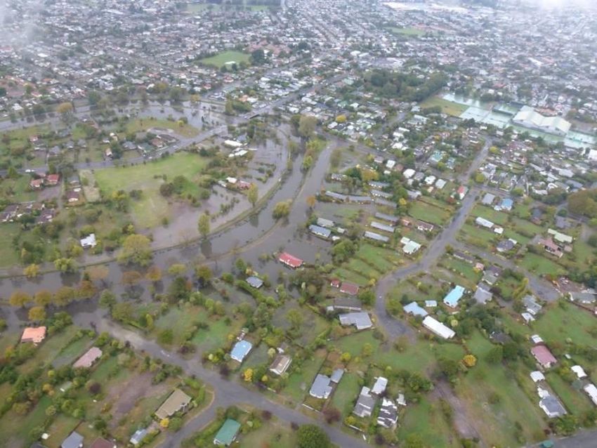
floods, there were efforts to stabilize the river to protect settlements from flooding, particularly
from the southern part of the river towards Christchurch. Engineering efforts, including
stopbanks, were not successful in preventing major floods in 1940 and 1950. The last time the
Waimakariri left its present location and flowed through Christchurch city was 1957. In
response to these floods, a new river modification scheme was developed in 1960 to raise and
strengthen existing stop banks and add additional features such as erosion protection. In more
recent years, a secondary stopbank has been designed. This secondary stopbank includes
protection for up to a 1 in 10,000 year return period event (van Kalken, et al., 2007).

The stopbanks along the Waimakariri River were damaged during the 2010-2011 Canterbury
earthquake sequence and have subsequently been repaired. Damage to the stopbanks is detailed
in the previous two GEER reports related to these events (GEER Association Reports No.
GEER-024 and GEER-027).

Christchurch City Rivers

The three main rivers within the city of Christchurch are the Styx, Avon, and Heathcote Rivers.
Along the eastern edge of the city is the Halswell River which drains to Te Waihora Lake
Ellesmere. The three main urban rivers are spring fed and run through populated areas of the city
(Figure 2-3). The flat and low-lying areas surrounding these rivers have been prone to periodic
flooding throughout the city’s history. Additionally, the city’s development and growth has
contributed to increased runoff and flooding from these rivers. Floods from these rivers are
typically generated by moderate-intensity, long-duration rain storms (Christchurch City Council,
2003).

The Styx River, to the north, has experienced floods and flooding exacerbated by tidal
inundation. Commissioned in the mid-1980s, tide-gates have been installed on the Styx Figure
2-4) to limit tidal effects upstream and to protect the floodplains near the stopbanks of the
Waimakariri River to the north (Taylor, 2005).
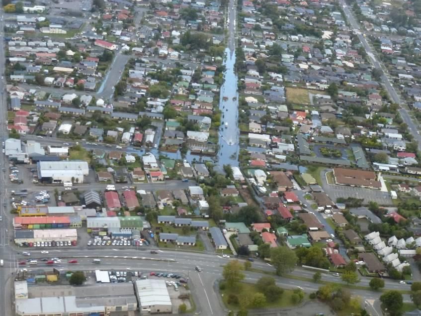
Figure 2-3 Major catchments in Christchurch City (Tonkin and Taylor, 2013).

Figure 2-4 Tide-gates on the Styx River at Brooklands (Christchurch City Council, 2012).
In the Avon River basin, over 30 floods since 1883 have been documented and have caused
damage ranging from stormwater ponding to river breakouts. In July 1955, March 1957 and
August 1992, high tides exacerbated the flooding. Flood control measures, including stopbanks,
are installed along the lower Avon to protect property from flood damage. The performance of
these stopbanks is detailed in Chapter 6 of this report. Following the 2010-2011 earthquake
sequence, the suburb of Avonside experienced extensive subsidence. As a result, the stopbanks
were increased in height by up to 1 meter in some places (Figure 2-5).

The Flockton area or Dudley Creek basin, a sub-catchment of the wider Avon River basin,
experiences frequent flooding. The Flockton area has experienced numerous flood events from
Dudley Creek (Figure 2-6), which is a tributary of the Avon River. This area was flooded in
August 2012, June 2013 and March 2014. Prior to the earthquake sequence, this area was prone
to flooding, but the frequency and magnitude of flooding seems to have increased since the
earthquakes. To alleviate flooding, a pump was installed to move the flood waters. Figure 2-7
shows the 50 year flood levels in the Flockton area before and after the earthquake sequence. As
demonstrated by comparisons between Figures 2-7a and 2-7b, there are much larger areas
potentially subject to flooding after the earthquake sequence as compared to before the
earthquakes – shown as the larger extent of the areas colored orange to red to indicate deeper
flood waters.

  Figure 2-5 Stopbank along the Avon River on Avonside Drive (-43.503590°, 172.683632°).
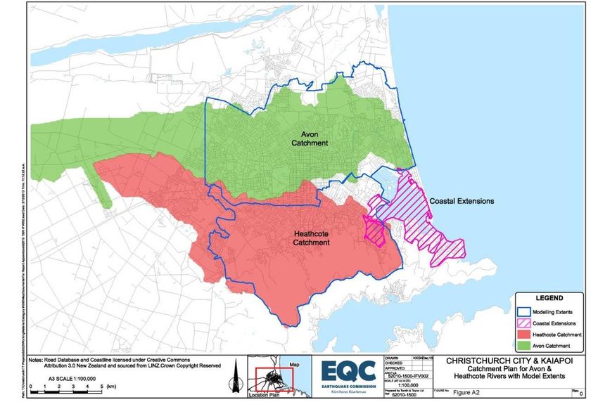
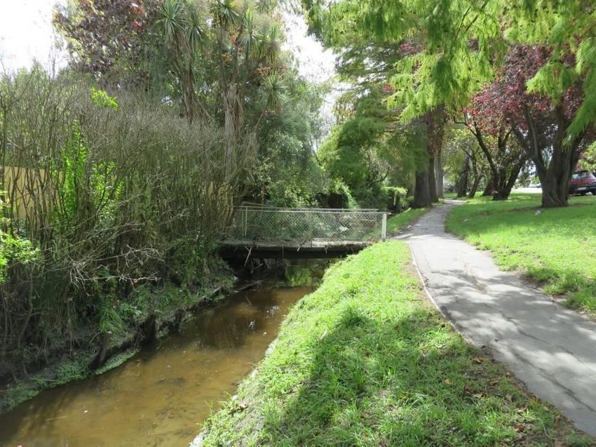
Figure 2-6 Bridge over Dudley Creek (-43°30’ 40.41” S, 172°39’18.52”E) along Stapletons
                                         Road.

                                          (a)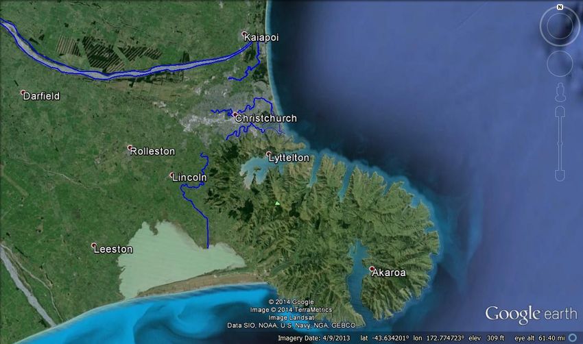
(b)
Figure 2-7 50 year flood levels in the Flockton area: (a) before, and (b) after the earthquake
sequence (Christchurch City Council, 2014).

Figure 2-8 Barrage on the Woolston Cut section of the lower Heathcote River (-43°33’ 11.72”S,
                                     172°41’07.33”E).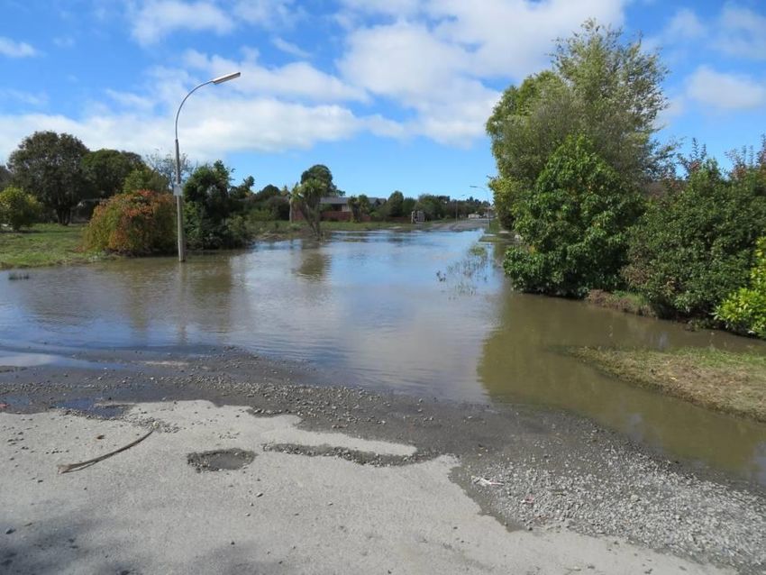
The Cranford basin comprises a local depression in Christchurch that is a natural flood ponding
area draining to both the Styx and the Avon basins. The basin is approximately 89 hectares and
is frequently inundated. The basin was flooded in the March 4-5, 2014 event. The Christchurch
City Council is considering the purchase of this land to establish it as a local drainage reserve
(Christchurch City Council, 2012).

Similar to the Styx and Avon, the Heathcote River has had numerous floods. In 1941, the
Woolston Cut was added in an attempt at river flood mitigation. However, this straightening of a
lower river channel reach allowed saltwater to flow more readily back up the river. A barrage
was added to prevent the saltwater backup Figure 2-8. Prior to the earthquake sequence
floodwaters reached heights above house floor levels in the Heathcote River basins in 1968,
1975, 1977 and 1980 (Christchurch City Council, 2003).

March 4-5, 2014 Flood

During the period of March 4th to 5th, 2014, a 992 hPa tropical depression sat east of the
Canterbury coast for several days, providing heavy and sustained rainfall over the wider city.
Rain gauges recorded a high degree of spatial variation in total precipitation across the city, with
gauges measuring values of 78 mm at Lower Styx Road, 160.8 mm at the Botanical Gardens, to
341.2 mm towards Akaroa, a settlement that lies south of the city and on the south-side of Banks
Penninsula (Table 2-1). The precipitation amounts correspond to events with annual return
periods ranging from 1-in-20 to 1-in-100 (Tonkin & Taylor, 2014). The most significant damage
occurred in the communities along the Avon and Heathcote Rivers, the two main rivers that drain
the eastern, coastal half of the city.

At the same time as the large rainfall event occurred, coastal water levels were also high. There
was a storm surge associated with the low pressure weather system that produced the flooding.
Tonkin & Taylor (2014) estimates the storm surge at a maximum of between 0.3 and 0.4 m.
Adding to this, there was a tide of 20-50% annual exceedance probability (1-in-5 to 1-in-2 return
period). This large tide is referred to as a perigean spring tide or king tide.
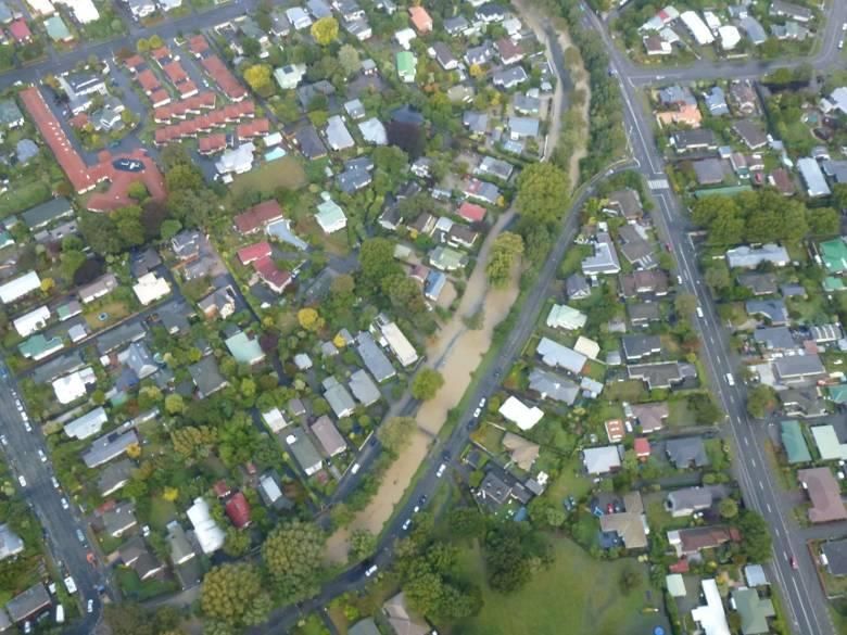
Table 2-1 Rainfall levels recorded by Christchurch City Council gauges from 3-6 March 2014
(provided by Tonkin and Taylor, 2014)

                            Site                         Basin      Rainfall Depth (mm)

        Site 324607 Lower Styx Rd                      Styx         78
        Site 324608 PS62, Tyrone Street                Styx         76.2
        Site 324610 Firestone Factory, Papanui         Avon         139.6
        Site 325403 PS80, Templeton                                 82.4
        Site 325507 College of Education, Ilam         Avon         120.8
        Site 325510 Halswell Retention Basin           Halswell  106
        Site 325512 Aidanfield, Dunbars Reservoir                107.2
        Site 325616 Christchurch Botanical Gardens     Avon      160.8
        Site 325617 Horseshoe Lake, PS205              Avon      133.2
        Site 325618 PS42, Sparks Road                  Halswell 141.8
        Site 325619 Tunnel Road, Heathcote             Heathcote 150.6
        Site 325621 Bowenvale Flume                    Heathcote 180.2
        Site 325711 Van Asch St. Sumner                Sumner    180
        Site 325712 Reservoir No.4, Clifton Tce        Sumner    189
        Site 325716 Ocean outfall, Sth Brighton                  133
        Site 326616 Upper Bowenvale Valley             Heathcote 297.6
        Site 325615 Kyle St EWS                                  152.4
        Site 327804 4960 Chch-Akaroa Hwy                         341.2

The variability in the precipitation spatial distribution led to localized flooding rather than
widespread flooding (Figure 2-9). The Waimakariri River did not experience flooding and the
stopbanks performed as expected. Locally, in Christchurch, flooding was experienced along the
Avon River (Figure 2-11 through Figure 2-15), most notably, Dudley Creek, and the Heathcote
River as well as localized stormwater ponding (Figure 2-15).

The area that experienced the greatest flooding in this event is an area called Flockton. The
Flockton area along Dudley Creek and the Avon River has experienced historical flooding. Due
to the 2010-2011 earthquake sequence, ground subsidence has occurred in this area, making it
more susceptible to flooding. Additionally, there was silting of the creek and lateral spreading
that narrowed the channels, reducing their hydraulic capacity; these topics are discussed in detail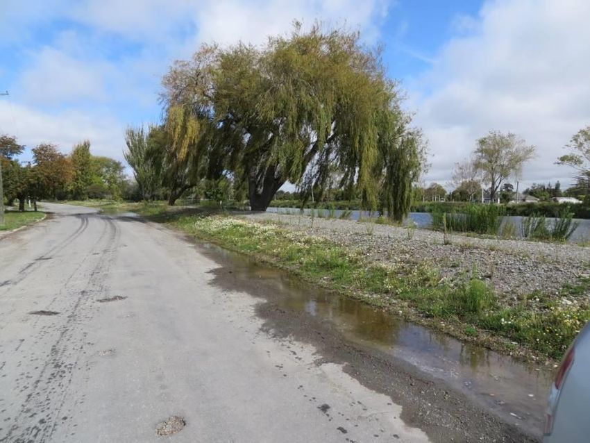
in Chapters 3 and 5. Figure 2-10 is a schematic of the area that demonstrates the 50 year flow
against the existing channel capacity (Christchurch City Council, 2014).

Similar to the Avon, the Heathcote also experienced flooding (Figure 2-16 through Figure 2-18).
The photos provided from Tonkin and Taylor begin at the top of the basin and proceed towards
the ocean. The upper part of the basin had ponding (Figure 2-16). This area has been identified
by the Christchurch City Council as a natural ponding basin and has been left without
development to capture flood waters. Figures 2-11 to 2-18 present photographs showing flood
waters within the City of Christchurch. The Mayoral Task Force (Christchurch City Council,
2014) report provides more detailed descriptions of local flood impacts and temporary defense
measures and the later chapters in this report summarize flood effects on geotechnical and
lifeline systems.

                                                      A

                                                          B

Figure 2-9 Observed flooding in Christchurch in March 2014 with general location of the (A)
Cranford Basin and (B) Flockton area compared to hindcast model predictions (Tonkin &
Taylor, 2014).
Figure 2-10 Flockton area channel capacity shown with 50 year flows in the arrows and current
channel capacities in red (Christchurch City Council, 2014).
Figure 2-11 Lower Avon River at New Brighton Road (-43°30’02.52”S, 172°41’03.65”E). Photo
courtesy of Tonkin & Taylor 2014.Figure 2-12 Avon River at Gayhurst Road (43°31’17.58”S, 172°, 40’21.96”E). Photo courtesy of
Tonkin & Taylor 2014.
Figure 2-13 Localized flooding at the intersection of Prestwick Street and Avonside Drive (-
43.503590°, 172.683632°). Photo courtesy of Tonkin & Taylor 2014.Figure 2-14 Flockton area from Woodville Street (43°30’33.65 S”, 172°39’00.65”E). Photo
courtesy of Tonkin & Taylor 2014.
Figure 2-15 Localized flooding in Manning Place & Wilberry Street (43°32’41.63 S”,
172°39’58.28”E). Photo courtesy of Tonkin & Taylor 2014.Figure 2-16 Heathcote River off Worsley Road (-43.580827°, 172.616142°). Photo courtesy of
Tonkin & Taylor 2014.
Figure 2-17 Heathcote River Waimea Tce (43°34’08.59’ S, 172°38’22.22” E). Photo courtesy of
Tonkin & Taylor 2014.(a) (b) Figure 2-18 Heathcote River off Centaurus Road illustrating (a) flooding on March 5, 2014 (Credit: Tonkin & Taylor 2014) and (b) normal flow during GEER visit March 19, 2014. (43°34’01.69”S, 172°38’45.85”E).
References

Christchurch City Council (2003) Christchurch City Environmental Trends Report. [online]
http://resources.ccc.govt.nz/files/01TitleAndContentsEnvironmental-docs.pdf Accessed April 2,
2014

Christchurch City Council (2012) “Stormwater Management Plan for the Styx River/Pūrākanui
Area - Part B: Blueprint for Surface Water Management “ [online]
http://files.ecan.govt.nz/public/ccc-styx/crc131249-appendix-c.pdf Accessed April 2, 2014

Christchurch City Council (2014) Land Drainage Recovery Programme: Dudley Creek – Options
Feasibility Report March 2014.
http://resources.ccc.govt.nz/files/CityLeisure/projectstoimprovechristchurch/landdrainage/Dudle
yCreekFloodManagementRestorationFeasibilityReport.pdf

Christchurch City Council (2014) Mayoral Flood Taskforce, Temporary Flood Defence
Measures: Technical Report Final Draft,
http://www.ccc.govt.nz/cityleisure/projectstoimprovechristchurch/landdrainage/taskforce.aspx,
accessed May 24, 2014.

Taylor, M. (2005) “Inaga Spawning on the Lower Styx River” AEL Aquatic Ecology Limited
May 2005 Styx Report: 2205/1 AEL28. [online]
http://www.thestyx.co.nz/content/library/Inanga_Spawning_20051_AEL_28.pdf . Accessed
April 2, 2014

Tonkin & Taylor (2014) 4/5 March, 2014 Flood Event. Report prepared by: Tonkin & Taylor
Ltd Distribution: Tonkin & Taylor Ltd (FILE)April 2014 T&T Ref: 52010.150van Kalken, T., T.

Oliver, I. Heslop, and T. Boyle (2007). Impacts of Secondary Flood Embankments on the
Waimakariri Floodplain, New Zealand, Proc. 32 nd Congress of IAHR, July 1-6, 2007, Venice,
Italy

van Kalken, T., T. Oliver, I. Heslop, and T. Boyle (2007). Impacts of Secondary Flood
Embankments on the Waimakariri Floodplain, New Zealand , Proc. 32 nd Congress of IAHR,
July 1-6, 2007, Venice, Italy
You can also read