Housing Supply Side Options - A review of Government owned land holdings potentially suitable for conversion to residential housing - Department ...
←
→
Page content transcription
If your browser does not render page correctly, please read the page content below
Housing Supply Side
Options
A review of Government owned land holdings potentially
suitable for conversion to residential housing
March 2018
2
1     Contents
1    Contents ................................................................................................................................... 3

2    Executive Summary ................................................................................................................ 4

3    Introduction ............................................................................................................................. 5

4    Background .............................................................................................................................. 5

5    Methodology ............................................................................................................................ 7

6    Outcomes of the review..................................................................................................... 11

7    Highlighted properties......................................................................................................... 14

8    Australian Government and council properties............................................................ 19

9    Miscellaneous properties .................................................................................................... 20

10   Consultation .......................................................................................................................... 21

11   Conclusion ............................................................................................................................. 21

      Appendix 1: Organisations contacted......................................................................22

      Appendix 2: List of potentially suitable Government owned properties........23

      Appendix 3: Terms of Reference..............................................................................27

      Appendix 4: Membership of Steering Committee and Working Group.........30

      Appendix 5: Map of public housing demand...........................................................31

      Appendix 6: Organisations that were consulted on identified properties......33

                                                                                                                                                      3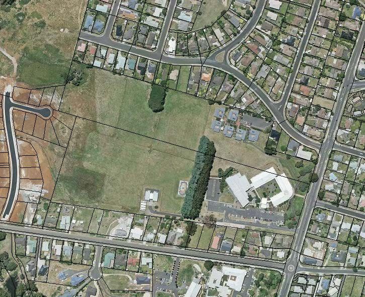
2      Executive Summary
A key initiative of the Government’s Affordable Housing Strategy 2015-2025 is the prevention of
housing stress and homelessness through the provision of new affordable supply. To assist in
delivering this outcome, in the 2017-18 Budget the Treasurer announced a broad scale whole-
of-government review to assess what underutilised government land may be suitable for
repurposing into housing. This report details the methodology and outcomes of the review, and
documents which Government land holdings may be suitable for that purpose.

The review was undertaken using a multi-stage approach of identification, assessment, analysis,
and consultation. Attention was focused on local government areas where there is high demand
for affordable housing. These are Burnie, Devonport, Latrobe, Launceston, Brighton, Sorell, the
Huon Valley, Hobart, Glenorchy and Clarence. Beginning with a list of all government owned
properties in these areas, the review systematically eliminated unsuitable land parcels until a final
list of properties remained. State Government agencies, government businesses, councils and
relevant Australian Government departments were also contacted to identify any underutilised
land holdings.

The site assessment methodology relied heavily on a criteria based assessment system that
assigned points to properties according to a set of desirable attributes. This system was used to
filter properties and determine which were most likely to be suitable for supporting residential
housing. From this system, a preliminary shortlist of suitable properties was created. Consultation
on shortlisted land parcels then occurred between Treasury and property owners, during which
owners were given the opportunity to demonstrate why a property identified in the shortlist
should not be considered for repurposing.

A Steering Committee chaired by Treasury and with membership from Housing Tasmania; and
the Departments of Premier and Cabinet; Education; and Primary Industries, Parks, Water and
Environment was established to oversee the review. Additionally, a Working Group comprised
of representatives of people vulnerable to housing stress and homelessness, construction and
housing industry groups and government agencies provided assistance and feedback as the review
progressed. This group provided advice on the site assessment criteria, helped to evaluate the
preliminary shortlist of suitable properties, and contributed to the finalisation of this report.

The review revealed that the Government holds 139 hectares across 28 land parcels that may be
suitable for residential development. Six of the ten high demand municipalities are represented
in this outcome, with land identified in Burnie, Clarence, Glenorchy, Hobart and Launceston. This
paper highlights five properties that are considered to have the most potential for repurposing
to housing. A full list of the 28 land parcels is provided at Appendix 2.

Additionally, three local councils identified surplus land within their boundaries that may be
available for development as residential housing. These councils were Sorell, Devonport City and
the Huon Valley. These are three of the four high demand areas that are not represented by
Government owned land. No land was identified as surplus by any of the Australian Government
departments that were contacted.

The review also identified St Johns Park precinct in New Town and the former Nurses Quarters
in Launceston as two miscellaneous properties where further analysis could be undertaken to
learn more about the possibility of these sites supporting residential housing.

Given the need to consult with councils and communities, develop site designs and rezone many
of the identified properties, it is likely that any development on the identified sites would occur
in the medium to long term.

                                                                                                   4
3      Introduction
Housing is fundamental to the welfare of all Australians and the issue of housing affordability is a
key policy issue being considered at all levels of Government.

The Council of Australian Governments and the Council on Federal Financial Relations have been
working for some time on a range of initiatives to maximise opportunities for all Australians to
access affordable, safe, appropriate and sustainable housing. This is in addition to the introduction
of various policies to address housing issues by the Australian Government and all State and
Territory Governments.

At the state level, the Tasmanian Government’s Affordable Housing Strategy 2015-25 documents
the high level housing policy for the ten year period beginning in September 2015. The desirable
outcomes of the Strategy are to decrease the proportion of low income households experiencing
housing stress and to decrease the proportion of Tasmanians experiencing homelessness. The
Government’s Affordable Housing Action Plan 2015-2019 articulates the priorities in housing policy
that will assist in the achievement of the Strategy’s outcomes over its first four years.

A key initiative of the 2015-2019 Action Plan is the prevention of housing stress and homelessness
through new affordable supply. The plan states that the Government can stimulate supply and
ensure that new dwellings are appropriate for those in vulnerable housing situations. The
repurposing of underutilised Government-owned land is an action that can assist in delivering
this outcome. Accordingly, this report has been prepared following a review of Government land
holdings that may be suitable for conversion to housing.

4      Background
4.1    Housing affordability
Housing affordability, that is, the prices of residential dwellings relative to household incomes, is
an area that can place increased pressure on household finances. While the wider population may
be required to spend a higher proportion of their income on housing if prices increase, the impact
on low income households is disproportionally worse. Not only must these households pay more
for their residential accommodation as broader prices rise, but as housing costs increase,
affordable housing options in the private market are taken up by moderate and high income
earners, who are generally favoured by private landlords. This limits the amount of affordable
housing available to low income households and forces them into more expensive properties,
which further increases housing stress.

While the release of additional land for residential development is a positive, governments
generally have little control over housing affordability, as the key drivers such as property prices,
rental rates, interest rates and household income are outside their control. The area where
governments can have the most impact for communities is through the provision of dwellings
that are made directly available to those most vulnerable to housing stress and homelessness.
The first step in this process is to identify land on which dwellings can be constructed.

The Affordable Housing Strategy identifies that housing stress and the risk of homelessness can be
reduced if there is adequate and appropriate supply of affordable houses. The challenge is to
increase supply of affordable homes such that demand is being met, but also to ensure that the
homes are appropriate. To that end, new supply needs to have reasonable access to social
infrastructure such as employment opportunities, education centres, health services, retail
services and active communities.

                                                                                                   5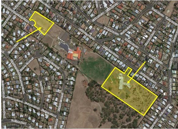
4.2    Government review announced
In the 2017-18 Budget, the Treasurer announced a broad scale whole-of-government review to
assess what underutilised government land may be suitable for repurposing into housing. It was
envisaged that any identified land would have the potential to support the Government’s
Affordable Housing Strategy or to increase the availability of supply in the broader market.

Financing and delivery arrangements to establish housing on the land identified was not in the
scope of the review.

A Steering Committee chaired by Treasury and with membership from Housing Tasmania; and
the Departments of Premier and Cabinet; Education; and Primary Industries, Parks, Water and
Environment was established to oversee the review.

Additionally, a working group with representation from Housing Tasmania, TasCOSS, Shelter
Tasmania, the Housing Industry Association, Master Builders Tasmania, DPIPWE and Treasury
was assembled. The group was convened to ensure that any identified land parcels were suitable
for end users, and to maximise the probability that developers will be in a position to deliver
completed dwellings as soon as possible should development of any of the sites progress.

A full copy of the Terms of Reference are provided at Appendix 3 and the membership of both
the Steering Committee and Working Group is provided at Appendix 4.

A discussion of the review’s methodology and its findings are discussed in the following sections.

                                                                                                 6
5          Methodology
The review was undertaken using a multi-stage approach of: identification; assessment; analysis;
and consultation. Beginning with a list of all government owned properties over 0.1 hectares, the
review systematically eliminated unsuitable land parcels until a final list of properties remained.
This process is discussed in detail below.

5.1        Identification of land parcels
The review began with the identification of all Government and Government business land within
the high demand local government areas of Burnie, Devonport, Latrobe, Launceston, Brighton,
Sorell, the Huon Valley, Hobart, Glenorchy and Clarence. Areas of high demand were informed
by the Affordable Housing Strategy and through consultation with Housing Tasmania. Appendix 5
provides an illustration of the demand for public housing in Tasmania.

The review’s Terms of Reference exclude the examination of land reserved under the
Nature Conservation Act 2002 or land reserved for public use as public reserves under the
Crown Lands Act 1976. Additionally, the Terms of Reference prescribed a minimum land size of
0.1 hectares to ensure that any identified parcels could support multiple residential dwellings.

To increase the probability that no parcel of land was overlooked, two independent strategies
were utilised for the identification of properties. The first strategy involved the extraction of
property data from the Land Information System (LIST) managed by the Department of Primary
Industries, Parks, Water and Environment. This process yielded in excess of 2 200 individual land
parcels and included properties with no title.

Additionally, government agencies and government businesses were contacted and requested to
self-identify any underutilised land holdings located within the demand areas. A list of contacted
organisations is provided in Appendix 1.

5.2        Assessment of identified parcels
In order to filter the properties identified, a criteria based assessment system was devised that
measured the suitability of a property for supporting residential dwellings. Each property was
assessed with regard to its:
      1.   zoning status;
      2.   landslip hazard status;
      3.   improvement status;
      4.   water service access;
      5.   sewerage service access;
      6.   proximity to public transport;
      7.   proximity to a primary school; and
      8.   proximity to a high school.

The assessment system allocated points to a property when the status of a desirable attribute
was positive. For example, a property with access to the water network was awarded a point,
whereas no access yielded no point. Properties accumulated points such that the more positive
attributes it had, the more points it was awarded. A property with eight points had necessarily
scored a point for each desirable attribute and was accordingly ranked above a property with
seven points, which itself ranked above a property with six points, and so on, on their likelihood
of suitability for residential housing.

While the criteria used to assess properties are not exhaustive of the requirements or desirable
attributes for residential development, the criteria based assessment system is an appropriate
                                                                                                  7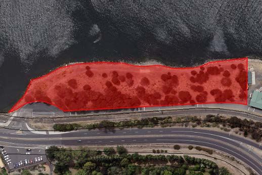
way to rank properties from most to least desirable given the available data. It is notable that the
absence of any one criteria does not preclude the property from consideration for residential
development. However, the absence of many indicates that the property is unlikely to have close
proximity to important social infrastructure, or is unlikely to be able to support residential
housing without significant investment.

Each of the eight desirable attributes, and the factors considered when determining whether a
property was assessed positively against it, are discussed below.

Zoning status
One point was awarded to properties with a zoning status of either: General Residential, Inner
Residential; Low Density Residential, Rural Living, Environmental Living, Urban Mixed Use,
Village, or Inner City Residential. Properties of any other zoning status were considered less
desirable as zoning changes would be required. This uncertainty would at best delay the
construction of dwellings, and at worst, prevent development altogether.

Landslip hazard
Properties with no landslip hazard, or a low landslip hazard, were awarded one point.

The Tasmanian Planning Scheme - State Planning Provisions: Landslip Hazards Code defines four
landslip hazard bands. These are: low, medium, medium-active, and high. Under some
circumstances, the code permits development, including subdivision, on land with a low landslip
rating without solutions to mitigate the landslip. For this reason, low landslip hazard band
properties are considered equally desirable as properties with no landslip hazard, and were
accordingly awarded equal value in the assessment system.
Properties that are subject to medium and high grade landslip may require mitigating actions
before development can occur and are therefore less desirable. This has been reflected by the
absence of a point for those properties.

Improvement status
Vacant land is most suitable for the development of residential housing and the absence of
improvements also indicates a land parcel may not be fully utilised. Therefore, one point was
awarded to properties where no improvements were listed. Properties with existing
improvements received no points for this category.

Water and sewerage infrastructure
It is important that a residential dwelling has access to water and sewerage services. Ideally, this
is through the established water and sewerage network operated by TasWater. As such,
properties that have the ability to connect to a full water connection scored one point, while
properties with a limited water connections scored 0.5 points. Properties that are able to connect
directly to the existing sewerage network also scored an additional point.

Public transport and schools
Proximity to public transport and schools are both desirable attributes when considering a
properties suitability for residential housing. The ability to access public transport may allow a
person to access employment opportunities, health care services, community spaces and other
locations or services important to communities. Additionally, the close proximity of a school can
also be used as a proxy to indicate the availability of important social infrastructure such as health
care, child care and other support services within a reasonable distance.

                                                                                                    8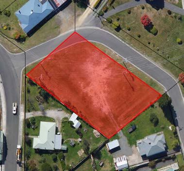
Accordingly, a property within 250 meters of a bus stop was awarded one point, a property
within 500 metres was awarded 0.5 of a point and a property within one kilometre was awarded
0.25 of a point. Similarly, a property within five kilometres of a primary school was awarded one
point and a property within 10 kilometres of a primary school scored 0.5 of a point. Properties
less than 10 kilometres from a high school scored an additional point.

The social infrastructure characteristics were largely limited by what data were available. For
example, a property’s proximity to health services would be a desirable attribute but no data
were available to support that analysis. Appropriate distances to schools and public transport
were provided by members of the project’s Working Group, particularly TasCOSS and Shelter
Tasmania.

5.3     Analysis
Elimination of immediately unsuitable properties
The assessment system described above provided a way to analyse and rank the approximately
2 200 government owned land parcels that had been identified in the initial stages of the review.
However, due to its design, the system ranked highly some government owned properties that
were fully utilised. Examples of such properties include: Government offices, law courts, police
stations, fire stations, schools, hospitals, roads and gaols. These properties were eliminated from
further analysis by manually assigning a score of zero.

Likewise, it was necessary to manually eliminate some properties that were entirely unsuitable
for supporting residential dwelling. These included flood basins and transmission line corridors.
As with high ranking government land that is fully utilised, these properties were manually
assigned a score of zero.

Table 1a: Examples of eliminated properties, already utilised
                                 73-79 Charles St, Launceston
                                 Original score: 7 out of 8
                                 Reason for exclusion: Property currently
                                 occupied by Launceston Magistrates Court.

                                                         32 Shield St Huonville
                                                              Original score: 8 out of 8
                                    Reason for exclusion: High voltage power lines
                                                               bisect the property

Threshold for further analysis
After the elimination of immediately unsuitable properties and properties that had scored zero
on the ranking system, approximately 1 000 land parcels remained as viable sites for further
analysis. At this stage it was decided that only properties that had scored five points or greater
on the assessment system would be analysed further.

This threshold was chosen as it was determined that the absence of at least three desirable
attributes, for example: non-residential zoning, no sewerage network access and medium to high
grade landslip hazard, would broadly indicate a property was unlikely to be suitable. This decision
allowed more detailed analysis of properties that had a higher probability of being able to support
affordable housing. Properties assessed with a score below five may need significant investment,
such as major site works or additional bulk water and sewerage infrastructure. It also ensured
that any identified properties were more likely to be close to social infrastructure and
‘appropriate’ for affordable housing, as indicated in the Affordable Housing Strategy.
                                                                                                  9
Table 1b: Examples of eliminated properties, score below five
                                 2 Domain Highway, Queens Domain
                                 Original score: 4.5 out of 8
                                 Positive attributes: Vacant land, no landslip,
                                 proximity to primary and high schools, 500m
                                 from public transport
                                 Negative attributes: Not residential zone, no
                                 water or sewerage access. This site is also
                                 difficult to access and is used for public
                                 recreation
                                                    Curlew St Primrose Sands
                                                            Original score: 2 out of 8
                                     Positive attributes: Vacant land and no landslip
                                     Negative attributes: Not residential zone, no
                                  water or sewerage access, no public transport,
                                                        no primary or high school

The design of the assessment system, where the points available for non-binary characteristics
such as proximity to public transport are reduced as distances increase, helps to mitigate the risk
that a property may be relegated to a lower rank due to being a negligible distance beyond the
threshold. For example, a property that is 251 metres from a bus stop, and therefore just outside
the desirable distance, still received 0.5 of one point, rather than zero points. This points scaling
is not possible for attributes such as zoning status or access to sewerage infrastructure, where
there are no degrees of compliance, but rather the characteristic demonstrates a yes or no status.

Notwithstanding these attempts to minimise the probability that a property at the margin has
been overlooked, it is possible that a relaxation of criteria would increase the number of suitable
properties that have been identified. However, it is probable that these properties would be less
desirable than those which this report identifies.
The application of a minimum score of 5 reduced the number of properties to around 300.

Analysis of shape and location
The remaining land parcels were further assessed for suitability against their shape and proximity
to waterways. This process resulted in the elimination of approximately 250 of the 300 remaining
properties for either being river corridors, or too narrow to support development.
A shortlist of approximately 50 candidate properties remained which formed the basis for
consultation between owners and Treasury.

                                                                                                   10
Table 1c: Example of eliminated properties, narrow foreshore
Co-ordinates: 444895, 5443072
This land parcel has no title or Property Identification Number. It is located at Coles Beach, Devonport.
It originally scored 5 out of 8, but was eliminated from consideration due to being a narrow foreshore corridor.
This property is indicative of many others that were eliminated at this stage.
5.4 Consultation
Treasury undertook bilateral consultation with Department of State Growth, the Department of
Education, the Department of Health and Human Services, the Department of Primary Industries,
Parks, Water and Environment and TasNetworks as the owners of shortlisted properties. Each
organisation was provided a list of properties that scored five or greater and were given the
opportunity to demonstrate why a property should not be considered suitable for residential
development. Additional information held by these organisations about suitable properties was
also shared at this time.
Many properties were eliminated from consideration as a result of these meetings, with various
legitimate reasons provided. For example, the assessment system had identified properties that
had been recently acquired for road developments, were fully utilised as carparks, had recently
been developed or were being held for future expansion projects. When appropriate, these
properties were excluded from further consideration.
Consultation with the University of Tasmania also occurred regarding its campuses in Newnham
and Burnie 1. While this consultation remains ongoing, it is agreed that surplus land will become
available when the respective campuses are relocated.
6 Outcomes of the review
6.1 Key findings
The review identified approximately 139 hectares across 28 government owned properties that
may be suitable for conversion into residential housing. Six of the ten high demand areas are
represented in the final list of properties. These are Burnie, Clarence, Glenorchy, Hobart and
Launceston. Land has also been identified in all the major regional population centres of the South,
North and North-West.
Eighteen of the identified land parcels have an available area of greater than one hectare, indicating
that these properties can potentially support the development of a significant number of
1
Property owned by the Department of Education, with UTAS a long term tenant.
11dwellings. Hobart, Burnie and Launceston are each home to one of the three largest sites
identified by the review, meaning that each region has at least one significant land holding suitable
for supporting residential development.
Seven of the 28 identified properties have residential zoning, which means a change of land use
will be required for development to progress on 21 of the sites. Public transport is available
within 250 metres for 22 of the sites, and the remaining 6 sites have access within 1 000 metres.
Every identified site has a primary school within a 5 kilometre radius and is no more than
10 kilometres from a high school.
Included in the 28 properties are eight land parcels, totalling 22.2 hectares, that are outside the
high demand areas on which this review focused. Four properties in the Derwent Valley, three
on the Central Coast and one in Kingborough make up the eight out of demand area properties.
There are also four properties that are below the 0.1 hectare minimum size. Two properties are
both outside the demand are and below the minimum size.
Out of demand area properties, or properties below the minimum land size, were only included
in this report if they were volunteered by agencies in the initial identification process and scored
five or greater on the assessment system. The data extraction from the LIST and subsequent
analysis did not include out of demand areas or properties below 0.1 hectares.
Tables 2 and 3 below provide an overview of the owners and location of the final properties
potentially suitable for conversion to residential housing. A full list of suitable properties is
provided in Appendix 2.
Table 2: Number and area of properties by owner
Owner No. of Total area
properties (ha.)
Department of Primary Industries, Parks,
6 74.74
Water and Environment
Department of Education 5 23.16
Department of State Growth 11 22.74
Department of Health and Human Services 2 11.87
University of Tasmania 1 4.87
Tasmanian Networks 3 1.56
Total 28 138.94
Table 3: Number and area of properties by Local Government Area
Local Government Area No. of Total area
properties (ha.)
Launceston 6 37.96
Clarence 5 35.77
Burnie 3 34.86
Derwent Valley 4 10.79
Central Coast 3 9.64
Glenorchy 4 5.86
Hobart 2 2.26
Kingborough 1 1.81
Total 28 138.94
126.2 Housing Tasmania properties
The purpose of the review was to identify government owned land that could support residential
housing and is suitable for conversion into this use. Housing Tasmania is the owner of
approximately 100 hectares of land across 50 parcels within the high demand municipalities.
It is considered that these properties are already well positioned to contribute to the supply of
additional dwellings in Tasmania and were excluded from any detailed analysis. This enabled more
attention to be focused on identifying additional land that can increase supply of both affordable
housing and the housing market more generally. Accordingly, the findings of this report exclude
properties already owned by Housing Tasmania.
6.3 Public reserves
Public reserves under the Crown Lands Act 1976 were deemed not underutilised due to the
recreation value they deliver to local communities. This is reflected in the Terms of Reference
that preclude analysis of land reserved for public use.
However, the review revealed that there is approximately 120 hectares of potentially vacant
public reserve land across 43 parcels that scored greater than five on the criteria based
assessment system. There has been no further analysis of these properties and it is likely that
many have high recreation value for local communities, or may be leased to local governments
to benefit their populations. However, it is also possible that further analysis and wider
consultation may reveal that some of these parcels, or portions of some of these parcels, may be
underutilised and suitable for residential development.
6.4 Long term council leases
For the purposes of this review, land parcels with long term leases to councils were considered
council-owned properties and excluded from analysis. However, the review identified that some
of these properties may be suitable for supporting residential housing. As is the case with public
reserves, further analysis and further consultation would be required to determine suitability.
6.5 Land associated with schools
The Department of Education has advised that it is currently undertaking an assessment of the
land surrounding its school sites. With the exception of land already identified as surplus by the
DoE, land which currently forms part of a school site was not considered as part of this review.
137 Highlighted properties
The following sections provide a brief discussion of the land parcels that are considered the most
likely to be suitable for supporting residential development.
7.1 62 Ashbourne Gr, West Moonah
PID 5407459
Area 1 2.5 hectares
Area 2 0.53 hectares
Key Information The suitable land covers two areas located to the north and south of
Springfield Gardens Primary School, both of which are currently zoned
Community Purpose under the Glenorchy City Council Planning Scheme.
The parcels are currently owned by the Department of Education.
Area 1 has separate vehicle access from Ashbourne Grove, and is adjacent
to Jim Bacon Memorial Reserve which is owned by Glenorchy City
Council. Area 2 has vehicle access from Thornleigh Street.
Rezoning and subdivision would be required on both parcels should
conversion to residential housing progress. Area 1 also houses the former
campus of Springfield Gardens Primary. Development of Area 1 would
need to consider repurposing or removal of this building.
Area 2
Approx. 0.53 ha
Area 1
Approx. 2.5 ha
147.2 8 Debomfords Lane, Geilston Bay & 271 East Derwent Highway
PID Area 1: 5116379 (Debomfords Lane)
Area 2: 251889/2, 227372/1, 227371/1 (Part titles) (East Derwent Hwy)
Area 1 1.76 hectares
Area 2 0.38 hectares
Key Information The available land covers two parcels to the north and west of Lindisfarne
North Primary School. Both areas have been identified as surplus to
current needs by the Department of Education. Both parcels are zoned
Open Space under the Clarence City Council Planning Scheme.
Area 1 is located adjacent to Geilston Bay sporting clubs and has access
off Debomfords Lane. Access to Area 2 requires further investigation.
Anecdotally, Area 1 is used as car parking by spectators and players when
the adjacent sports oval is hosting games. Alternative parking options may
need to be considered should development on this site progress.
Area 1
Approx. 1.76 ha
Area 2
Approx. 0.38 ha
157.3 Techno Park Dr, Kings Meadows
PID 3197996
Area 1: 0.83 hectares
Area 2: 5.16 hectares
Key Information The suitable land is located in the Technopark precinct in the Launceston
suburb of Kings Meadows. Both parcels are zoned Particular Purpose and
are adjacent to existing residential housing. The properties have close
proximity to public transport and schools.
Access to Area 2 can be gained through Woolven Street, Technopark
Drive and potentially via a vacant property owned by Launceston City in
Medina Street, although the Council has not been consulted on this
possibility at this time. Area 1 can be accessed via Technopark Drive.
The land is owned by Tasmanian Development and Resources (TDR) and
its acquisition and disposal is governed by the
Tasmanian Development Act (1983). Should conversion into residential
housing progress, endorsement from the TDR would be required. This
endorsement would then need to be approved by the Minister for State
Growth.
Area 1
Approx. 0.83 ha
Area 2
Approx. 5.16 ha
167.4 16-20 Mooreville Rd Park, Grove, Burnie
PID 6187275 and 6193261
Area 9.1 hectares
Key Information The property is currently the North West Campus of the University of
Tasmania and Area 1 will become vacant when the campus is relocated
to West Park. The land is owned by the Department of Education, with
the University a long term tenant. Both parties have agreed to terminate
the lease as a part of the campus relocation. As part of that agreement,
UTAS will remain in possession of Area 2, which are residential units
used as student accommodation.
The land is zoned Particular Purpose and has multiple access points via
Mooreville Road and West Mooreville Road.
The existing UTAS campus building is relatively new, and preliminary
discussions with stakeholders suggest it would be retained and
repurposed. The significant vacant land at the site could be subdivided
and developed with residential dwellings.
Area 1
Approx. 9.1 ha Area 2
UTAS to retain
177.5 21 Gregson St, Risdon
PID 2065481
Area 32.54 hectares
Key Information Area 1 is located in Risdon and is the largest site identified by the review.
Its current zoning status is Open Space.
There are multiple points of access via Saunders Road, Risdon Street,
Church Point Road and Gregson Street.
The land use is listed as park and recreation, however this is for valuation
purposes only.
Area 2 is a reservoir, which occupies approximately 0.1 hectares, and
Area 3 is a Sewerage Treatment Plant, both owned by TasWater. Should
development progress, consultation would need to be undertaken to
determine if any exclusion zones would be required, or if there is any
surrounding underground infrastructure that would need to be
considered.
Area 3
TasWater Sewage
Treatment Plant
Area 2
TasWater reservoir
Area 1
Approx. 32.5 ha
188 Australian Government and council properties
Although underutilised State Government land was the focus of the review, councils and
Australian Government departments were provided the opportunity to self-identify any surplus
land holdings that would be suitable for residential development. A complete list of the councils
and departments that were contacted is provided at Appendix 1.
8.1 Australian Government departments
The Department of Finance and Department of Defence both advised that no surplus land was
available for inclusion in the review.
8.2 Council properties
Ten municipal councils were contacted and invited to contribute to the review. The councils of
the Huon Valley, Devonport City and Sorell each indicated that surplus land potentially suitable
for residential development had been identified. No surplus land holdings were identified by
councils in the remaining areas of high demand. However, the Hobart City Council has advised
that it is in the early stages of preparing a report that will identify any land holdings that have the
potential to support housing development.
Table 4 below is a list of the 7 properties that have been identified by councils as surplus.
However, the three properties identified by the Huon Valley adjoin to form one larger site. The
inclusion of these properties in this report does not commit any council to the sale, transfer or
development of the properties. Should any interested parties wish to progress development on
any of the sites listed in Table 4, further discussions would be required with each respective
owner.
Table 4: Properties identified as surplus by councils
Area Planning
PID Property Address Owner (ha.) Zone Other information
Devonport Council advises
that there are significant
planning issues to resolve
80-82 River Rd, Devonport City Environmental before residential
2652459 Ambleside Council 1.87 Management development could occur
This property is currently on
24-26 Triton Rd, East Devonport City General the market. No sale as at
7404921 Devonport Council 0.07 Residential 16/11/2017
The three Huon Valley
Huon Valley Council properties adjoin to
7830242 14 George St, Cygnet Council 2.50 Multiple form one larger site
The three Huon Valley
20 Golden Valley Rd, Huon Valley General Council properties adjoin to
2036840 Cygnet Council 0.98 Residential form one larger site
The three Huon Valley
Huon Valley Council properties adjoin to
7672344 8 George St Cygnet Council 0.26 Village form one larger site
400 Carlton River Rd, Low Density
5914207 Carlton River Sorell Council 0.99 Residential Vacant land
General Dwelling - Sorell Youth
5932675 11 Fitzroy St, Sorell Sorell Council 0.09 Business Centre Building
199 Miscellaneous properties
The analysis of such a large dataset of properties has revealed some government land holdings
that do not strictly fit into the review methodology, but nonetheless may be suitable for further
consideration for conversation into residential housing. These sites are St John’s Park in New
Town (including the adjacent DPIPWE laboratories) and the former nursing quarters in the
Launceston General Hospital precinct.
The following sections provide a brief discussion on the current use of each property, and why
it may be suitable for an alternative use. It is acknowledged that the repurposing of each site into
residential housing would likely be a significant individual project, each with its own unique issues
and considerations. This report has not attempted to quantify those issues, nor has any
commitment by Government been made to the repurposing any of the sites. The inclusions of
these properties signifies that conversion to residential housing may be possible, and that further
work would be required to determine the viability of that claim.
St Johns Park, New Town
The St Johns Park Site and adjacent DPIPWE laboratories are currently occupied by the
Department of Health and Human Services, the Department of Primary Industries, Parks, Water
and Environment and various non-Government organisations. The site includes research
laboratories, greenhouses, administrative buildings, aged care facilities, medical services and
community groups. The park has rich historical and cultural values, and is permanently listed on
the Tasmanian Heritage Register.
The site is close to both the Hobart and Glenorchy business districts, as well as schools, health
care services and employment opportunities. A preliminary and brief analysis suggests that the
site has many of the attributes that are desirable for supporting residential development.
St Johns Parks is currently arranged in an ad hoc nature and its physical state may be deteriorating.
There may be substantial capacity for the development of St Johns Park precinct, and any
development could have multiple benefits, including additional floor space, more efficient usage
and increased conservation of its heritage values.
If there is an appetite to analyse the viability of re-purposing the site, strong consideration would
need to be given to the relocation of the current occupants. Of pivotal importance would be
whether this could be achieved in a smaller footprint or at a lower cost than is currently achieved.
Of equal importance would be an assessment of the site’s suitability for supporting residential
housing, or some other alternative purpose. To date, this analysis has not been undertaken in
any detail. Given the site’s large size, diverse usage, complex cultural significance and current
occupancy, it is likely that any analysis for potential conversion of the site would be a significant
project.
Nursing quarters in the Launceston General Hospital precinct
The former Nurses Accommodation, accessed from Frankland Street in Launceston, is a heritage
listed building constructed in 1897. Previously commissioned to provide accommodation to
nurses employed at the Launceston General Hospital, the property is now vacant. Situated close
to the centre of Launceston, this building may be well positioned to provide residential housing
to Launceston residents. However, as previously advised, repurposing this site would require
significant further analysis.
2010 Consultation
Following the identification of the 28 potentially suitable properties, the project team undertook
targeted consultation with relevant councils and Government agencies, a list of which is available
at Appendix 6. This consultation was in addition to that already achieved through the Steering
Committee and Working Group, both of which provided wide representation from various
stakeholders.
The purpose of the targeted consultation was to inform each stakeholder of the outcomes of the
review, including sharing the identified sites, and to learn what further issues may need to be
considered should development on any of the identified sites be progressed.
The discussions confirmed that each identified site is likely to have its own unique considerations
that could not be reasonably identified by this review’s methodology. Nonetheless, the overall
response from the majority of stakeholders was positive and a willingness to work through the
relevant issues was apparent. Accordingly, this consultation should be viewed as an opening
dialogue that will need to be continued if and when the development or disposal of the identified
sites is progressed.
11 Conclusion
The Housing Supply Side Options Project has identified a number of Government sites that can
be repurposed into residential dwellings. With suitable land parcels located in six of the ten areas
of high demand for affordable housing, the findings of the review serve to inform Government of
both where land is available for conversion to housing, and where land is not available.
As previously discussed, the methodology of this review involved a process of elimination that
identified, analysed and consulted on Government land holdings in high demand areas. Alternative
methodologies could be used to analyse the same dataset, however it is likely that a similar
outcome would result.
The review’s findings identify that 21 of the 28 sites would require rezoning before any potential
development could begin. Of the seven sites that already have residential zoning, only three are
located within the high demand areas. Given that the process to rezone a site can take up to
18 months, and that the outcome of the process is not guaranteed, it is likely that any
development on the identified sites would occur in the medium to long term.
Housing Tasmania has advised that it has enough sites and projects to sustain its program of
works until the completion of the current Affordable Housing Action Plan, which ends in 2019.
Therefore, a synergy exists between the time when the identified sites are likely to become
development ready and when Housing Tasmania will be in a position take on additional projects.
The large scale development that may be possible at some of the sites dictates that consultation
between the Government and relevant councils would be required before even zone change
applications could commence. The large size of many of the sites also indicates that master
planning processes may be appropriate. Master planning would allow communities to contribute
design elements to the sites and would ensure that consideration is given to the appropriate mix
of affordable housing, private development, open spaces and community services.
It is also possible that a number of the smaller sites, some of which are among those that already
have residential zoning, could be sold directly into the private market using pre-existing
government asset disposal procedures.
21While the key outcome of the review is the land parcels that have been identified for conversion,
there is also value in knowing which high demand areas have a limited supply of suitable land. To
that end, this report can help to inform the Government’s strategic acquisition of land parcels
that can support affordable housing into the future.
The review has also identified where further analysis may result in the identification of additional
properties that could be used to increase housing supply. The most promising area to begin
further analysis would likely be land parcels that are declared public reserves under the Crown
Lands Act. This report has already acknowledged the high recreation value that many of these
reserves provide, however, given the time and inclination, it is probable that underutilised public
reserves would be identified. Consultation could also occur with councils that are the tenants of
long term leases to determine if vacant and leased crown land is still desired.
22Appendix 1: Organisations contacted to identify surplus land
Organisation
Government agencies Councils
Department of Premier and Cabinet Brighton Council
Department of State Growth Burnie City Council
Department of Health & Human Services Devonport City Council
Department of Justice Clarence City Council
Department of Education Glenorchy City Council
Department of Primary Industries, Parks, Water and
Hobart City Council
Environment
Department of Police, Fire and Emergency Management Huon Valley Council
Department of Treasury and Finance Latrobe Council
Tasmanian Audit Office Launceston City Council
Integrity Commission Sorell Council
Marine and Safety Tasmania
TasTAFE Australian Government departments
Macquarie Point Development Corporation Department of Finance
Tourism Tasmania Department of Defence
Tasmanian Health Service
Government businesses
Sustainable Timber Tasmania
Hydro Tasmania
Port Arthur Historic Site
Tasmanian Public Finance Corporation
The Public Trustee
Metro Tasmania
TasIrrigation
TasNetworks
Tasmanian Ports Corporation
TasRail
Tasracing
TT-LineAppendix 2: List of potentially suitable Government owned properties
The table below lisst the properties that may be suitable for conversion to residential dwellings. It does not include the council or miscellaneous properties
listed in the main body of this paper.
For each of the listed properties it is anticipated that there would be unique characteristics that require attention before any potential development could be
considered.
The appearance of a property in this list does not commit a property to be developed as residential housing. Likewise, the omission of a property does not
exclude the possibility that it may be developed in the future.
Interested Available
PID Address party area (ha) Zone Other information
6713642 Reservoir Rd, Rocherlea DoE 8.13 General Residential Vacant land. Site assessment has been completed by DoE in 2010.
Springfield Gardens Primary School, excess land recommended by DoE.
5407459 62 Ashbourne Gr, West Moonah DoE 3.03 Community Purpose Discussed in main section of report.
16-20 Mooreville Rd, Park Grove, University of Tasmania North West Campus. Discussed in main section of
6187275 Burnie DoE 9.10 Community Purpose report.
Warrane Primary School, excess land recommended by DoE. The available
land is a strip along the south eastern boundary. Access to the site is an issue
5165111 213 Cambridge Rd, Warrane DoE 0.76 Community Purpose that would require further attention, however, access options are available.
Located to the north of Lindisfarne North Primary School, and adjacent to
Geilston Bay sporting clubs. There is also approx 0.4ha available to the west
5116379 8 Debomfords Lane, Geilston Bay DoE 2.14 Open Space of the school. Recommended by DoE. Discussed in main section of report.
2065481 21 Gregson St, Risdon DPIPWE 32.54 Open Space Vacant Land. Discussed in main section of report.
Vacant land. DPIPWE has advised that subdivision plans have been developed
for the site. The zoning status is largely Rural Resource, however adjoining
3189523 50 Wildor Cr, Ravenswood DPIPWE 12.72 Multiple zonings properties are zoned General Residential.
Stanley Green Memorial Park. Grazing or pastoral primary production block.
Non-irrigated vacant land. The site adjoins a wastewater treatment plant and
6885604 Penquite Rd, Norwood DPIPWE 3.61 Rural Resource the available area may be reduced if an larger exclusion zone is required.
2939185 Stowport Rd, Wivenhoe DPIPWE 25.18 Rural Resource Vacant bush land.Interested Available
PID Address party area (ha) Zone Other information
7695853 Roslyn Av, Romaine DPIPWE 0.58 Open Space Vacant land.
Vacant residential block located on Mount Nelson bends. The land is
currently used to access a public walkway known as the “Mount Nelson
Steps”. It may be possible to incorporate pedestrian access into a
development design. DPIPWE has advised that it is used by the University of
Low Density Tasmania to access an adjoining property. Consultation with UTAS to
5624939 196 Nelson Rd, Mount Nelson DPIPWE 0.12 Residential determine if this is the only site access would need to be undertaken.
3197996 Techno Park Dr, Kings Meadows DSG 5.99 Particular Purpose Vacant land. Discussed in main section of report.
The majority of the land parcel is the Claremont Link Road. However, some
Environmental subdividing may be possible to create usable land. Property adjoins
NA Title Number: 197749/1 DSG 2.13 Management PID5332792, which is listed below.
Vacant residential block. Property adjoins 197749/1, which is also a DSG
5332792 38 Maroubra Cir, Chigwell DSG 0.07 General Residential (State Roads) property.
Property is on the Southern Outlet at the top of the hill exiting Hobart. The
site is land locked, however access could be gained through council property
zoned Public Open Space. Scored 4 by assessment system due in part to the
absence of water and sewerage connections. Surrounding properties have
access to networks so this property has been included in report due to likely
access to water and sewerage networks, which would increase score to 6
NA Title Number: 208584/1 DSG 2.14 Utilities out of 8.
Property is on Brooker Highway, opposite to Montrose Bay High School.
The majority of the property is road. However, some subdividing may be
possible to create usable land. Available area includes surrounding DSG
NA Title Number: 226129/1 DSG 0.63 Utilities (State Roads) properties.
Vacant residential block. Some of the land is a road and subdivision would be
required. Outside of demand area but included in report because DSG have
6758277 14 Lester Rd Penguin DSG 0.15 General Residential identified as surplus.
25Interested Available
PID Address party area (ha) Zone Other information
Residential dwelling. However, significant portion of the land is vacant.
Outside of demand area but included in report because DSG have identified
5731363 47 Summerleas, Rd Kingston DSG 1.81 Multiple zonings as surplus. The available land has residential zoning.
Vacant rural residential property. Does not have sewerage access, but
surrounding properties do. Parcel is vacant land. Outside of demand area but
included in report because DSG have identified as surplus. The available land
7277221 Pineleigh St, Penguin DSG 5.01 Multiple zonings is zoned Rural Resource.
Majority of land parcel is South Arm Highway. However, it may be possible
NA Title Number: 6109/1 DSG 0.25 Utilities to create some usable land through subdivision.
Property is adjacent to South Arm Highway. Available area includes property
62918/36, which is also a DSG (State Roads) property. Subdivision would be
NA Title Number: 62918/35 DSG 0.08 Utilities required. Smaller than 0.1ha but identified by DSG.
Grazing or pastoral primary production block. Non-irrigated vacant land.
6758357 Preservation Dr, Penguin DSG 4.48 Multiple zonings The available portion of the land is zoned Rural Living.
This site houses the Northern Suburbs Community Centre and Life Without
Barriers social support organisation. There is approximately 2.7 hectares of
vacant land at the site. DHHS has recently awarded a tender to demolish the
Northern Suburbs Community Centre. The majority of the available land is
3163147 3 Archer St, Rocherlea DHHS 2.65 Multiple zonings zoned Community Purpose.
The site is the location of Millbrook Rise, a rehabilitation centre operated by
the Tasmanian Health Service. There is significant vacant land at the
property. It is outside the high demand area but was identified as potentially
1906218 3 Hobart Rd, New Norfolk DHHS 9.22 Community Purpose suitable by DHHS.
Substation on land. Some parcels of the property may be suitable but rezone
would be required. Property adjoins Millbrook Rise. Outside demand area
but volunteered by TasNetworks. TasNetworks has advised that further
7157940 50 Dixon St, New Norfolk TasNetworks 1.39 Utilities consultation would be required if conversion were to proceed.
26Interested Available
PID Address party area (ha) Zone Other information
Adjoins properties at 50 Dixon St, 5 Hobart Road and Millbrook Rise.
Outside demand area and smaller than 0.1 ha but volunteered by
TasNetworks. TasNetworks has advised that further consultation would be
1908774 Hobart Rd, New Norfolk TasNetworks 0.09 General Residential required if conversion were to proceed.
Adjoins properties at 50 Dixon St, Hobart Road (PID1908774) and Millbrook
Rise. Outside demand area and smaller than 0.1 ha but volunteered by
TasNetworks. TasNetworks has advised that further consultation would be
1908782 5 Hobart Rd, New Norfolk TasNetworks 0.09 General Residential required if conversion were to proceed.
University of Tasmania - Newnham Campus. The Tasmanian Government
has agreed to remove the covenant on this property that restricts usage to
educational purposes. The University has plans to relocate the campus to
Inveresk and has committed to developing a master plan to guide the future
use of the site. Contingent on the removal of the covenant is UTAS allowing
University of development of residential dwellings on the vacant parcel of land along
6572376 75 Newnham Dr, Newnham Tasmania 4.87 Particular Purpose Brooks Road.
27Appendix 3: Terms of Reference Housing Supply Side Options Project Terms of Reference Version 2 Context: Housing is fundamental to the welfare of all Australians and the issue of housing affordability is a key policy issue being considered by all levels of Government. The Council of Australian Governments and the Council on Federal Financial Relations have been working for some time on a range of initiatives to maximise opportunities for all Australians to access affordable, safe, appropriate and sustainable housing. In tandem with this, the Australian Government and all State and Territory Governments have introduced a variety of policies to address issues in particular jurisdictions. Among other housing related initiatives, the Australian Government announced in the 2017-18 Budget that the National Affordable Housing Agreement would be replaced with a National Housing and Homelessness Agreement (NHHA). This will target jurisdiction specific priorities, including supply targets, planning and zoning reforms and renewal of public housing stock, while also supporting the delivery of frontline homelessness services. A Senior Officials Working Group reporting to Heads of Treasury Deputies has been established with representatives from all jurisdictions. This Group will be responsible for progressing the framework to establish the NHHA as well as progressing other joint State-Commonwealth housing related initiatives. The governance framework for this Group is still being finalised, including potential consultation arrangements. The 2017-18 Australian Government Budget also announced the establishment of a $1 billion National Housing Infrastructure Facility that will finance the critical infrastructure needed to speed up the supply of housing. In Tasmania, a review was announced in the 2017-18 Budget of options to promote additional affordable housing supply, with a key component of the review being the identification of underutilised government land and property held by Government Departments and Government businesses with a view to identifying properties suitable for renewal and repurposing to increase affordable housing supply or housing supply generally. This is in addition to the significant work being progressed by the Tasmanian Government as part of the Tasmanian Affordable Housing Strategy 2015-2025. Scope: The immediate target for underutilised Crown land will be land or properties located in well serviced areas close to transport corridors and employment and education opportunities to support inclusive residential developments and affordable living.
You can also read